Developing Flood Risk Zones during an Extreme Rain Event from the Perspective of Social Insurance Management
Abstract
1. Introduction
- How effective are hydrological simulations in creating flood risk zones that meet the requirements of flood-related insurance policies during extreme rainfall events?
- Is it possible to create flood susceptibility maps using a simulated flood inundation extent instead of hazard maps based on historical rain data?
- Lastly, can flood susceptibility mapping products be used by social insurance companies as a reliable guide or reference during specific heavy-rain events?
2. Materials and Methods
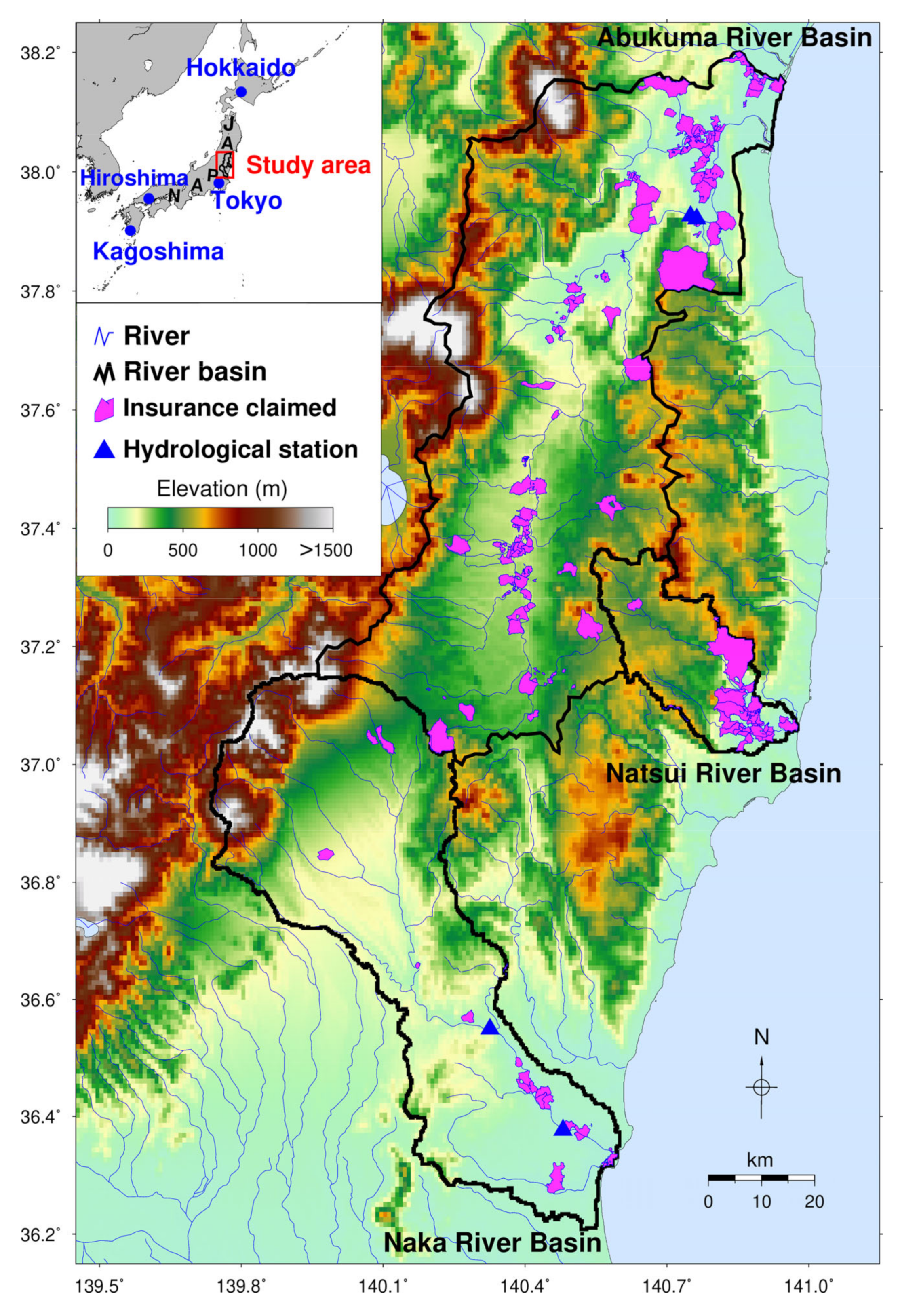
2.1. Study Area
2.2. Data
2.2.1. Rainfall Data
2.2.2. Topographic Data
2.2.3. River Discharge Data
2.2.4. Social Data
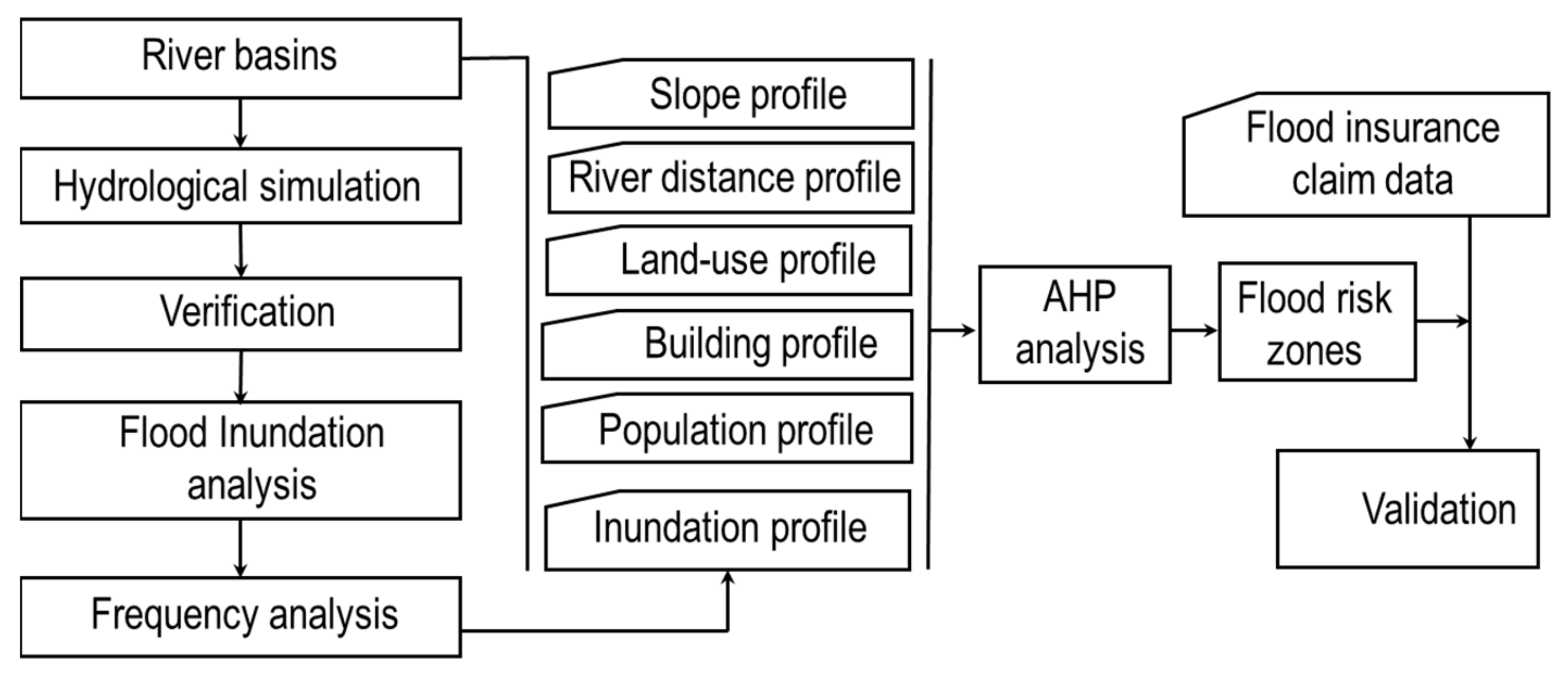
2.3. Methods
2.3.1. Hydrological Simulation
2.3.2. Analytic Hierarchy Process (AHP)
3. Results
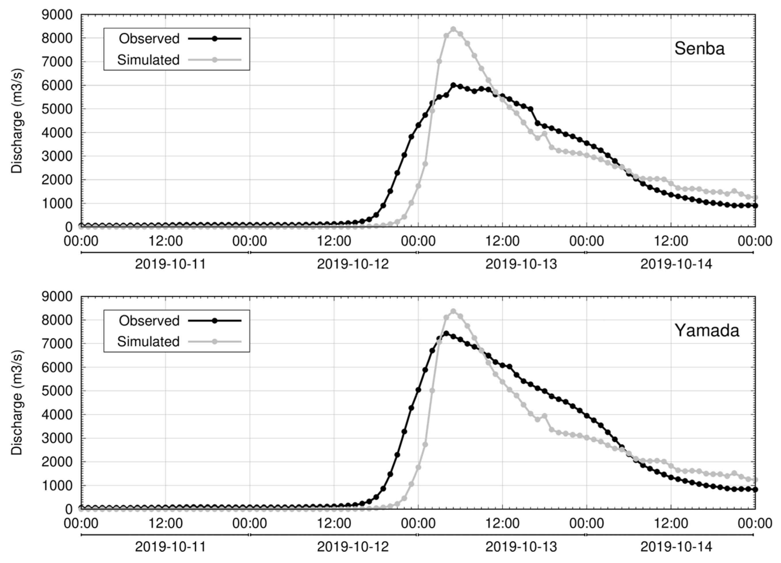
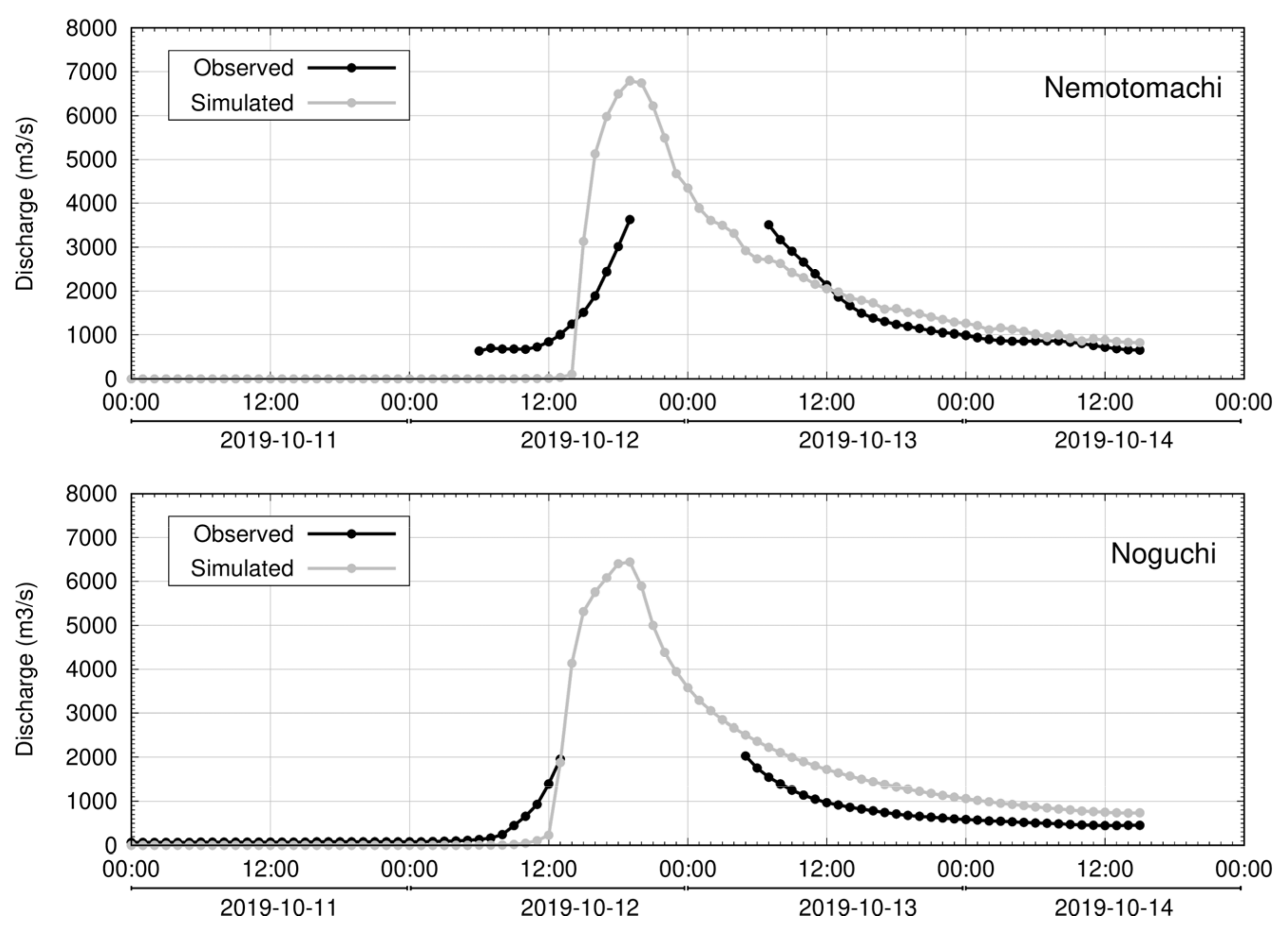
3.1. Simulated Discharge
3.2. Flood Inundation Depth Analysis
3.3. Influential Data Processing
3.3.1. Population Density (POP)
3.3.2. Building Density (BLD)
3.3.3. Land-Use Profile (LU)
3.3.4. Distance from River (DIS)
3.3.5. Slope Profile (SLP)
3.4. Flood Susceptibility Mapping
3.5. Validation of Flood Risk Map
4. Discussion
4.1. Application of Inundation Depth to the Flood Susceptibility Mapping
4.2. Flood Susceptibility Mapping for Social Insurance Business
5. Conclusions
Author Contributions
Funding
Institutional Review Board Statement
Informed Consent Statement
Data Availability Statement
Acknowledgments
Conflicts of Interest
References
- Chan, F.K.S.; Yang, L.E.; Mitchell, G.; Wright, N.; Guan, M.; Lu, X.; Wang, Z.; Montz, B.; Adekola, O. Comparison of Sustainable Flood Risk Management by Four Countries—The United Kingdom, the Netherlands, the United States, and Japan—And the Implications for Asian Coastal Megacities. Nat. Hazards Earth Syst. Sci. 2022, 22, 2567–2588. [Google Scholar] [CrossRef]
- Jiang, Y.; Luo, Y.; Xu, X. Flood Insurance in China: Recommendations Based on a Comparative Analysis of Flood Insurance in Developed Countries. Environ. Earth Sci. 2019, 78, 93. [Google Scholar] [CrossRef]
- Fan, J.; Huang, G. Evaluation of Flood Risk Management in Japan through a Recent Case. Sustainability 2020, 12, 5357. [Google Scholar] [CrossRef]
- NIED. Flood Inundation in Kurume-shi on 14–15 August 2021. (In Japanese). Available online: https://mizu.bosai.go.jp/key/20210814Inun (accessed on 17 October 2022).
- Surminski, S.; Thieken, A.H. Promoting Flood Risk Reduction: The Role of Insurance in Germany and England. Earth’s Future 2017, 5, 979–1001. [Google Scholar] [CrossRef]
- Surminski, S.; Oramas-Dorta, D. Flood Insurance Schemes and Climate Adaptation in Developing Countries. Int. J. Disaster Risk Reduct. 2014, 7, 154–164. [Google Scholar] [CrossRef]
- Alifu, H.; Hirabayashi, Y.; Imada, Y.; Shiogama, H. Enhancement of river flooding due to global warming. Sci. Rep. 2022, 12, 20687. [Google Scholar] [CrossRef]
- Hirabayashi, Y.; Mahendran, R.; Koirala, S.; Konoshima, L.; Yamazaki, D.; Watanabe, S.; Kim, H.; Kanae, S. Global Flood Risk Under Climate Change. Nat. Clim. Chang. 2013, 3, 816–821. [Google Scholar] [CrossRef]
- Kundzewicz, Z.; Kanae, S.; Seneviratne, S.; Handmer, J.; Nicholls, N.; Peduzzi, P.; Mechler, R.; Bouwer, L.M.; Arnell, N.; Mach, K.; et al. Flood risk and climate change: Global and regional perspectives. Hydrol. Sci. J. 2013, 59, 1–28. [Google Scholar] [CrossRef]
- P.C., S.; Misumi, R.; Nakatani, T.; Iwanami, K.; Maki, M.; Maesaka, T.; Hirano, K. Accuracy of Quantitative Precipitation Estimation Using Operational Weather Radars: A Case Study of Heavy Rainfall on 9–10 September 2015 in the East Kanto Region, Japan. J. Disaster Res. 2016, 11, 1003–1016. [Google Scholar] [CrossRef]
- P.C., S.; Nakatani, T.; Misumi, R. Analysis of Flood Inundation in Ungauged Mountainous River Basins: A Case Study of an Extreme Rain Event on 5–6 July 2017 in Northern Kyushu, Japan. J. Disaster Res. 2018, 13, 860–872. [Google Scholar] [CrossRef]
- P.C., S.; Kamimera, H.; Misumi, R. Inundation Analysis of the Oda River Basin in Japan During the Flood Event of 6–7 July 2018 Utilizing Local and Global Hydrographic data. Water 2020, 12, 1005. [Google Scholar] [CrossRef]
- P.C., S.; Hirano, K.; Iizuka, S. Flood Inundation Mapping of the Hitachi Region in the Kuji River Basin, Japan, During the October 11–13, 2019 Extreme Rain Event. J. Disaster Res. 2020, 15, 712–725. [Google Scholar] [CrossRef]
- P.C., S.; Hirano, K.; Iizuka, S.; Misumi, R. Quick Exposure Assessment of Flood Inundation: A Case Study of Hitoyoshi City in Kumamoto Prefecture, Japan. Res. Rep. NIED 2020, 85, 13–23. [Google Scholar] [CrossRef]
- Shao, J.; Hoshino, A.; Nakaide, S. How Do Floods Affect Insurance Demand? Evidence from Flood Insurance Take-up in Japan. Int. J. Disaster Risk Reduct. 2022, 83, 103424. [Google Scholar] [CrossRef]
- Aydin, M.C.; Sevgi, B.E. Flood Risk Analysis Using GIS-based Analytical Hierarchy Process: A Case Study of Bitlis Province. Appl. Water Sci. 2022, 12, 122. [Google Scholar] [CrossRef]
- Al-Aizari, A.R.; Al-Masnay, Y.A.; Aydda, A.; Zhang, J.; Ullah, K.; Islam, A.R.M.T.; Habib, T.; Kaku, D.U.; Nizeyimana, J.C.; Al-Shaibah, B.; et al. Assessment Analysis of Flood Susceptibility in Tropical Desert Area: A Case Study of Yemen. Remote Sens. 2022, 14, 4050. [Google Scholar] [CrossRef]
- Pham, B.T.; Phong, T.V.; Nguyen, H.D.; Qi, C.; Al-Ansari, N.; Amini, A.; Ho, L.S.; Tuyen, T.T.; Yen, H.P.H.; Ly, H.-B.; et al. A Comparative Study of Kernel Logistic Regression, Radial Basis Function Classifier, Multinomial Naïve Bayes, and Logistic Model Tree for Flash Flood Susceptibility Mapping. Water 2020, 12, 239. [Google Scholar] [CrossRef]
- Hu, S.; Cheng, X.; Zhou, D.; Zhang, H. GIS-based flood risk assessment in suburban areas: A case study of the Fangshan District, Beijing. Nat. Hazards 2017, 87, 1525–1543. [Google Scholar] [CrossRef]
- Vojtek, M.; Vojteková, J. Flood Susceptibility Mapping on a National Scale in Slovakia using the Analytical Hierarchy Process. Water 2019, 11, 364. [Google Scholar] [CrossRef]
- Hadian, S.; Afzalimehr, H.; Soltani, N.; Tabarestani, E.S.; Karakouzian, M.; Nazari-Sharabian, M. Determining Flood Zonation Maps, Using New Ensembles of Multi-criteria Decision-making, Bivariate Statistics, and Artificial Neural Network. Water 2022, 14, 1721. [Google Scholar] [CrossRef]
- Ighile, E.H.; Shirakawa, H.; Tanikawa, H. Application of GIS and Machine Learning to Predict Flood Areas in Nigeria. Sustainability 2022, 14, 5039. [Google Scholar] [CrossRef]
- Parsian, S.; Amani, M.; Moghimi, A.; Ghorbanian, A.; Mahdavi, S. Flood Hazard Mapping Using Fuzzy Logic, Analytical Hierarchy Process, and Multi-source Geospatial Datasets. Remote Sens. 2021, 13, 4761. [Google Scholar] [CrossRef]
- Askar, S.; Zeraat Peyma, S.; Yousef, M.M.; Prodanova, N.A.; Muda, I.; Elsahabi, M.; Hatamiafkoueieh, J. Flood Susceptibility Mapping Using Remote Sensing and Integration of Decision Table Classifier and Metaheuristic Algorithms. Water 2022, 14, 3062. [Google Scholar] [CrossRef]
- Swain, K.C.; Singha, C.; Nayak, L. Flood Susceptibility Mapping through the GIS-AHP Technique Using the Cloud. ISPRS Int. J. Geo-Inf. 2020, 9, 720. [Google Scholar] [CrossRef]
- Karymbalis, E.; Andreou, M.; Batzakis, D.-V.; Tsanakas, K.; Karalis, S. Integration of GIS-based Multicriteria Decision Analysis and Analytic Hierarchy Process for Flood-hazard Assessment in the Megalo Rema River Catchment (East Attica, Greece). Sustainability 2021, 13, 10232. [Google Scholar] [CrossRef]
- Alarifi, S.S.; Abdelkareem, M.; Abdalla, F.; Alotaibi, M. Flash Flood Hazard Mapping Using Remote Sensing and GIS techniques in Southwestern Saudi Arabia. Sustainability 2022, 14, 14145. [Google Scholar] [CrossRef]
- Danumah, J.H.; Odai, S.N.; Saley, B.M.; Szarzynski, J.; Thiel, M.; Kwaku, A.; Kouame, F.K.; Akpa, L.Y. Flood risk assessment and mapping in Abidjan district using multi-criteria analysis (AHP) model and geoinformation techniques, (cote d’ivoire). Geoenviron. Disasters 2016, 3, 10. [Google Scholar] [CrossRef]
- NHK (NHK WORLD-JAPAN). Typhoon Hagibis Aftermath. 2019. Available online: https://www3.nhk.or.jp/nhkworld/en/news/special/typhoon201919 (accessed on 20 November 2022).
- Das, S.; Alexander, J.; Ishiwatari, M.; Komino, T.; Shaw, R. Lessons from Hagibis: Learning to Cope with Intensifying Disasters in the Age of New Normal; CWS: Tokyo, Japan, 2020. [Google Scholar]
- Ma, W.; Ishitsuka, Y.; Takeshima, A.; Hibino, K.; Yamazaki, D.; Yamamoto, K.; Kachi, M.; Oki, R.; Oki, T.; Yoshimura, K. Applicability of a nationwide flood forecasting system for Typhoon Hagibis 2019. Sci. Rep. 2021, 11, 10213. [Google Scholar] [CrossRef]
- Liu, W.; Fujii, K.; Maruyama, Y.; Yamazaki, F. Inundation Assessment of the 2019 Typhoon Hagibis in Japan Using Multi-Temporal Sentinel-1 Intensity Images. Remote Sens. 2021, 13, 639. [Google Scholar] [CrossRef]
- Moya, L.; Mas, E.; Koshimura, S. Learning from the 2018 Western Japan Heavy Rains to Detect Floods during the 2019 Hagibis Typhoon. Remote Sens. 2020, 12, 2244. [Google Scholar] [CrossRef]
- Sugiura, I. Very-short-range Forecast of Precipitation in Japan. In Proceedings of the 14th Annual WRF Users’ Workshop, Boulder, CO, USA, 25–27 June 2013. [Google Scholar]
- Yamazaki, D.; Togashi, S.; Takeshima, A.; Sayama, T. High-resolution Flow Direction Map of Japan. J. JSCE 2020, 8, 234–240. [Google Scholar] [CrossRef]
- Sayama, T.; Ozawa, G.; Kawakami, T.; Nabesaka, S.; Fukami, K. Rainfall-runoff-inundation Analysis of the 2010 Pakistan Flood in the Kabul River Basin. Hydrol. Sci. J. 2012, 57, 298–312. [Google Scholar] [CrossRef]
- Saksena, S.; Merwade, V. Incorporating the Effect of DEM Resolution and Accuracy for Improved Flood Inundation Mapping. J. Hydrol. 2015, 530, 180–194. [Google Scholar] [CrossRef]
- Nguyen, T.T.; Nakatsugawa, M.; Yamada, T.J.; Hoshino, T. Flood Inundation Assessment in the Low-Lying River Basin Considering Extreme Rainfall Impacts and Topographic Vulnerability. Water 2021, 13, 896. [Google Scholar] [CrossRef]
- Sayama, T.; Yamada, M.; Sugawara, Y.; Yamazaki, D. Ensemble Flash Flood Predictions Using a High-resolution Nationwide Distributed Rainfall-Runoff Model: Case study of the Heavy Rain Event of July 2018 and Typhoon Hagibis in 2019. Prog. Earth Planet Sci. 2020, 7, 75. [Google Scholar] [CrossRef]
- Yoshimoto, S.; Amarnath, G. Applications of Satellite-Based Rainfall Estimates in Flood Inundation Modeling—A Case Study in Mundeni Aru River Basin, Sri Lanka. Remote Sens. 2017, 9, 998. [Google Scholar] [CrossRef]
- Scharffenberg, W. Hydrological Modeling System HEC-HMS. User’s Manual; Publication of US Army Corps of Engineers: Davis, CA, USA, 2016. [Google Scholar]
- Beven, K.J.; Lamb, R.; Quinn, P.F.; Romanowicz, R.; Freer, J. Top model. In Computer Models of Watershed Hydrology; Singh, V.P., Ed.; Water Resources Publications: Littleton, CO, USA, 1995; pp. 627–668. [Google Scholar]
- Liang, X.; Lettenmaier, D.P.; Wood, E.F.; Burges, S.J. A Simple Hydrologically Based Model of Land Surface Water and Energy Fluxes for General Circulation Models. J. Geophys. Res. 1994, 99, 14415–14428. [Google Scholar] [CrossRef]
- Sayama, T. Rainfall-Runoff-Inundation (RRI) Model. In Disaster Prevention Research Institute (DPRI); Kyoto University: Kyoto, Japan, 2017. [Google Scholar]
- P.C., S.; Nakatani, T.; Misumi, R. Hydrological Simulation of Small River Basins in Northern Kyushu, Japan, during the Extreme Rainfall Event of July 5–6, 2017. J. Disaster Res. 2018, 13, 396–409. [Google Scholar] [CrossRef]
- Saaty, T.L. The Analytic Hierarchy Process; McGraw-Hill: New York, NY, USA, 1980. [Google Scholar]
- Al-Harbi, K.M.A.S. Application of the AHP in Project Management. Int. J. Proj. Manag. 2001, 19, 19–27. [Google Scholar] [CrossRef]
- Goepel, K.D. Implementation of an Online Software Tool for the Analytic Hierarchy Process (AHP-OS). Int. J. Anal. Hierarchy Process 2018, 10, 469–487. [Google Scholar] [CrossRef]
- Moges, E.; Demissie, Y.; Larsen, L.; Yassin, F. Sources of Hydrological Model Uncertainties and Advances in their Analysis. Water 2021, 13, 28. [Google Scholar] [CrossRef]
- Bates, P.D.; Marks, K.J.; Horritt, M.S. Optimal use of High-resolution Topographic data in Flood Inundation Models. Hydrol. Process. 2003, 17, 537–557. [Google Scholar] [CrossRef]



Disclaimer/Publisher’s Note: The statements, opinions and data contained in all publications are solely those of the individual author(s) and contributor(s) and not of MDPI and/or the editor(s). MDPI and/or the editor(s) disclaim responsibility for any injury to people or property resulting from any ideas, methods, instructions or products referred to in the content. |
© 2023 by the authors. Licensee MDPI, Basel, Switzerland. This article is an open access article distributed under the terms and conditions of the Creative Commons Attribution (CC BY) license (https://creativecommons.org/licenses/by/4.0/).
Share and Cite
P. C., S.; Hirano, K.; Iwanami, K. Developing Flood Risk Zones during an Extreme Rain Event from the Perspective of Social Insurance Management. Sustainability 2023, 15, 4909. https://doi.org/10.3390/su15064909
P. C. S, Hirano K, Iwanami K. Developing Flood Risk Zones during an Extreme Rain Event from the Perspective of Social Insurance Management. Sustainability. 2023; 15(6):4909. https://doi.org/10.3390/su15064909
Chicago/Turabian StyleP. C., Shakti, Kohin Hirano, and Koyuru Iwanami. 2023. "Developing Flood Risk Zones during an Extreme Rain Event from the Perspective of Social Insurance Management" Sustainability 15, no. 6: 4909. https://doi.org/10.3390/su15064909
APA StyleP. C., S., Hirano, K., & Iwanami, K. (2023). Developing Flood Risk Zones during an Extreme Rain Event from the Perspective of Social Insurance Management. Sustainability, 15(6), 4909. https://doi.org/10.3390/su15064909


