Assessment of Land Degradation at the Local Level in Response to SDG 15.3: A Case Study of the Inner Mongolia Region from 2000 to 2020
Abstract
1. Introduction
2. Materials and Methods
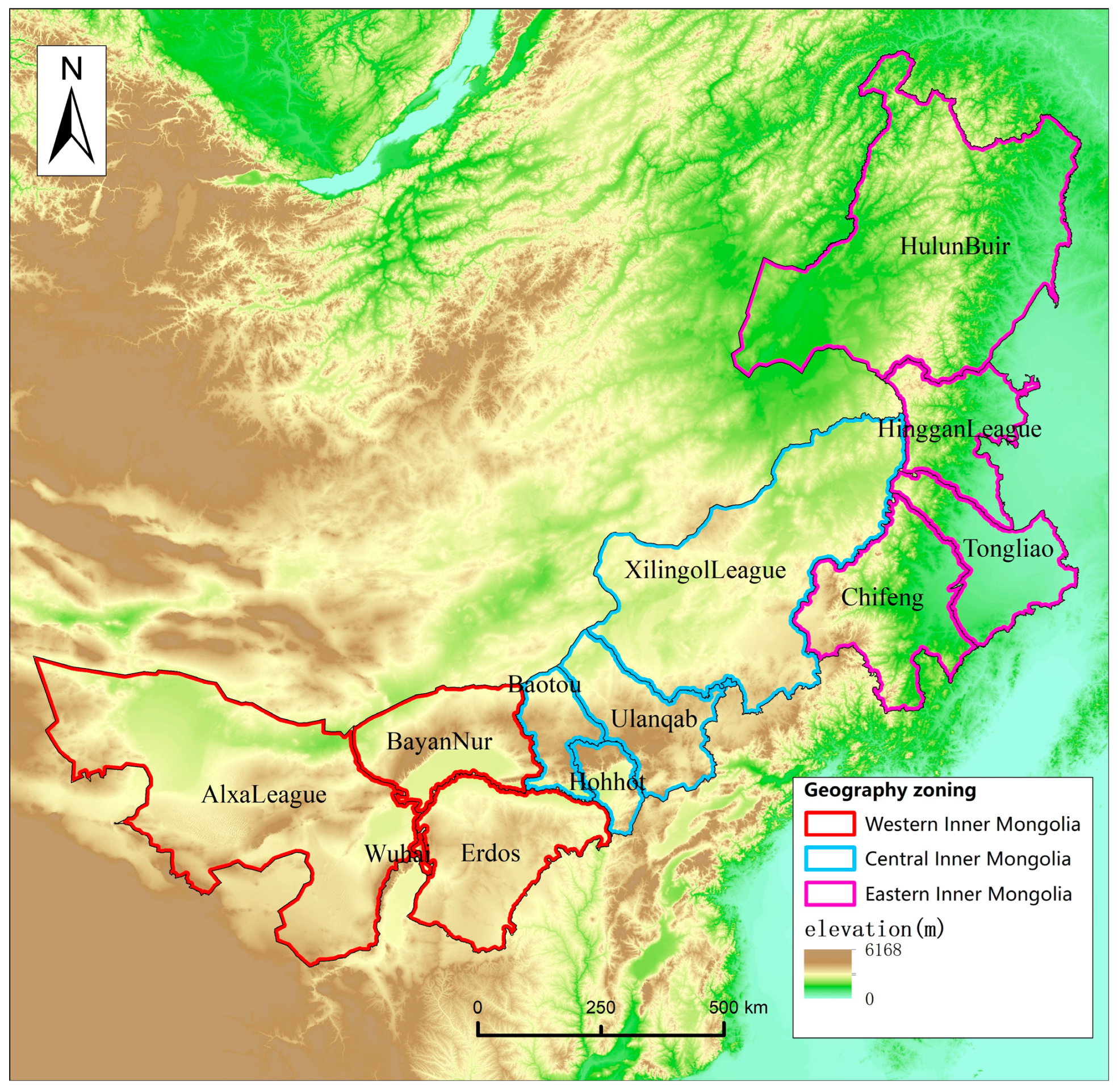
2.1. Study Area
2.2. Data and Preprocessing
2.2.1. Basic Data
2.2.2. Soil Data Estimation
- Estimation of SOC stocks
- 2.
- Estimation of wind erosion
- 3.
- Estimation of water erosion
2.3. Methods
2.3.1. Define the Localized Indicators for SDG15.3
- SOC stocks, wind erosion, and water erosion
- 2.
- NPP and FVC
- 3.
- Land cover
2.3.2. Standardization of Indicators
2.3.3. Assessment of Land Degradation and Improvement
- Determination of indicators weights
- 2.
- Calculation of land degradation and improvement degree
2.3.4. Assessment of LDN
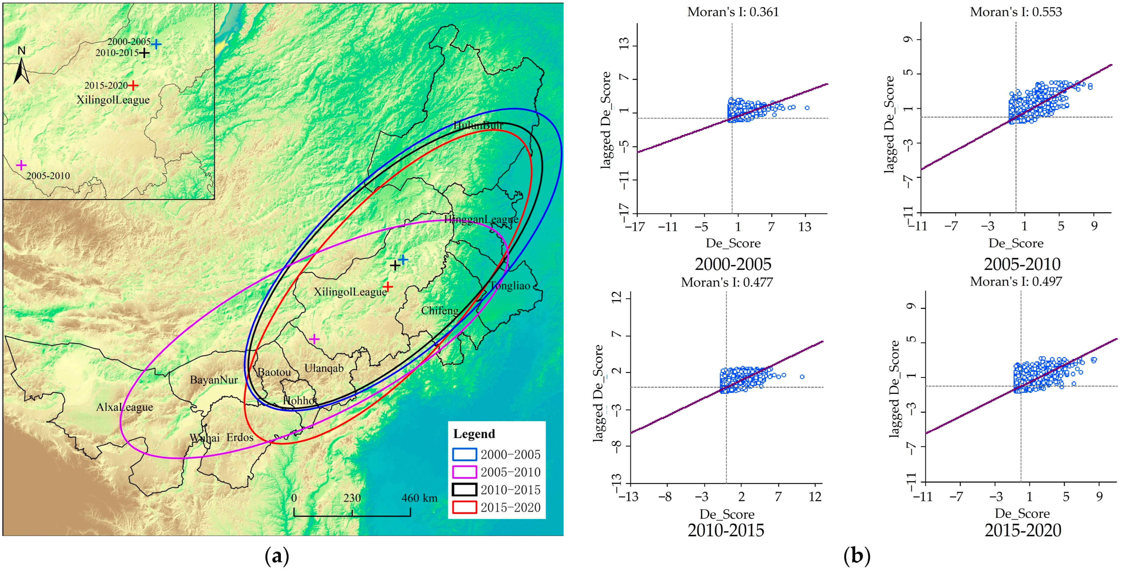
2.3.5. Spatial–Temporal Distribution Trend Analysis Method
- Standard Deviational Ellipse
- 2.
- Moran’s I
3. Results
3.1. Land Degradation and Improvement in Study Area over the Last 20 Years
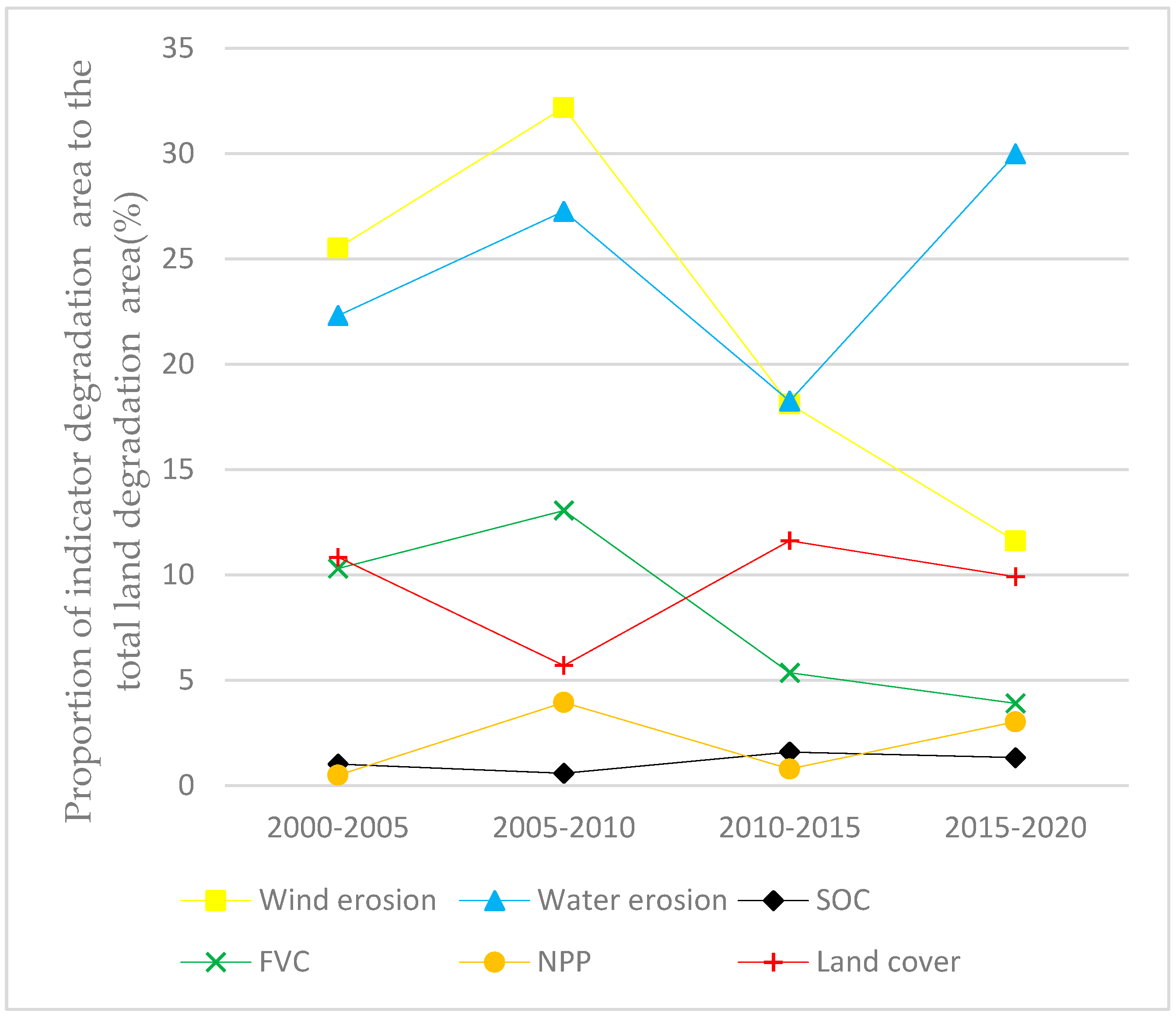
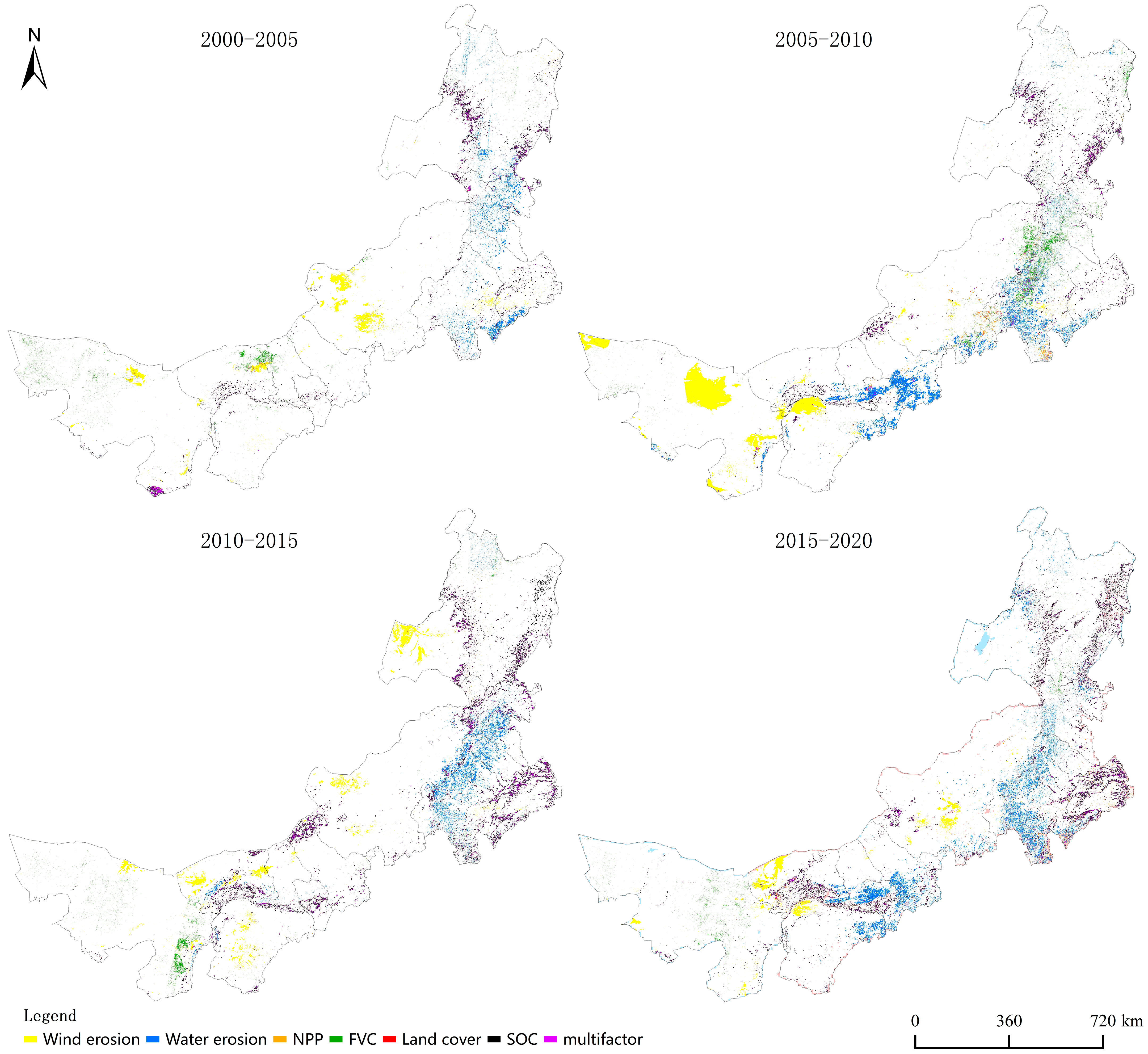
3.1.1. Land Degradation
3.1.2. Land Improvement
3.2. Assessment of SDG15.3 Progress in Study Area over the Last 20 Years
3.2.1. SDG15.3 Progress at Provincial Level
3.2.2. SDG15.3 Progress at Municipal Level
3.2.3. SDG15.3 Progress at County Level
4. Discussion
5. Conclusions
Author Contributions
Funding
Institutional Review Board Statement
Informed Consent Statement
Data Availability Statement
Conflicts of Interest
References
- Giuliani, G.; Chatenoux, B.; Benvenuti, A.; Lacroix, P.; Santoro, M.; Mazzetti, P. Monitoring land degradation at national level using satellite Earth Observation time-series data to support SDG15-exploring the potential of data cube. Big Earth Data 2020, 4, 3–22. [Google Scholar] [CrossRef]
- Sims, N.C.N.G. Good Practice Guidance. In SDG Indicator 15.3.1, Proportion of Land That Is Degraded Over Total Land Area; Version 2.0; United Nations Convention To Combat Desertification: Bonn, Germany, 2021. [Google Scholar]
- Li, X.; Lu, Q.; Jia, X. Harnessing Big Earth Data to Facilitate Land Degradation Neutrality Goals—Practices and Prospects. Bull. Chin. Acad. Sci. 2021, 8, 896–903. [Google Scholar]
- Cowie, A.L.; Orr, B.J.; Castillo Sanchez, V.M.; Chasek, P.; Crossman, N.D.; Erlewein, A.; Louwagie, G.; Maron, M.; Metternicht, G.I.; Minelli, S.; et al. Land in balance: The scientific conceptual framework for Land Degradation Neutrality. Environ. Sci. Policy 2018, 79, 25–35. [Google Scholar] [CrossRef]
- Guo, H. Big Earth Data in Support of the Sustainable Development Goals (2019); EDP Sciences: Les Ulis, France, 2021. [Google Scholar]
- IPBES; Willemen, L. Summary for Policymakers of the Assessment Report on Land Degradation and Restoration of the Intergovernmental Science-Policy Platform on Biodiversity and Ecosystem Services; IPBES Secretariat: Bonn, Germany, 2018. [Google Scholar]
- Barbier, E.B.; Hochard, J.P. Land degradation and poverty. Nat. Sustain. 2018, 1, 623–631. [Google Scholar] [CrossRef]
- Singh, S.; Dhyani, S.; Janipella, R.; Chakraborty, S.; Pujari, P.; Shinde, V.; Singh, K. Biomonitoring-Supported Land Restoration to Reduce Land Degradation in Intensively Mined Areas of India. Sustainability 2022, 14, 13639. [Google Scholar] [CrossRef]
- Lr, O.; Rta, H.; Wg, S. World Map of the Status of Human-Induced Soil Degradation: An Explanatory Note. Available online: https://isric.org/sites/default/files/isric_report_1990_07.pdf (accessed on 13 February 2023).
- Dalantai, S.; Sumiya, E.; Bao, Y.; Otgonbayar, M.; Mandakh, U.; Batsaikhan, B.; Natsagdorj, B. Spatial-temporal changes of land degradation caused by natural and human induced factors: Case study of bulgan province in central mongolia. Int. Arch. Photogramm. Remote Sens. Spatial Inf. Sci. 2021, XLIII-B4-2, 79–85. [Google Scholar] [CrossRef]
- Akinyemi, F.O.; Tlhalerwa, L.T.; Eze, P.N. Land degradation assessment in an African dryland context based on the Composite Land Degradation Index and mapping method. Geocarto Int. 2021, 36, 1838–1854. [Google Scholar] [CrossRef]
- Li, J.; Yang, X.; Jin, Y.; Yang, Z.; Huang, W.; Zhao, L.; Gao, T.; Yu, H.; Ma, H.; Qin, Z.; et al. Monitoring and analysis of grassland desertification dynamics using Landsat images in Ningxia, China. Remote Sens. Environ. 2013, 138, 19–26. [Google Scholar] [CrossRef]
- Zhang, J.; Niu, J.; Bao, T.; Buyantuyev, A.; Zhang, Q.; Dong, J.; Zhang, X. Human induced dryland degradation in Ordos Plateau, China, revealed by multilevel statistical modeling of normalized difference vegetation index and rainfall time-series. J. Arid Land 2014, 6, 219–229. [Google Scholar] [CrossRef]
- Kaplan, S.; Blumberg, D.; Mamedov, E.; Orlovsky, L. Land-use change and land degradation in Turkmenistan in the post-Soviet era. J. Arid Environ. 2014, 103, 96–106. [Google Scholar] [CrossRef]
- Ghebrezgabher, M.; Yang, T.; Yang, X.; Wang, C. Assessment of desertification in Eritrea: Land degradation based on Landsat images. J. Arid Land 2019, 11, 319–331. [Google Scholar] [CrossRef]
- Vu, Q.; Lakshmi, V.; Bolten, J. Assessment of the Biomass Productivity Decline in the Lower Mekong Basin. Remote Sens. 2019, 11, 2796. [Google Scholar] [CrossRef]
- Bishnoi, P.; Sharma, P.; Kumar, E.M. Analyzing dynamics of degraded lands using NDVI time-series in a semi-arid region of India. Arab. J. Geosci. 2021, 14, 828. [Google Scholar] [CrossRef]
- Bruzzone, O.; Easdale, M.H. Rhythm of change of trend-cycles of vegetation dynamics as an early warning indicator for land management. Ecol. Indic. 2021, 126, 107663. [Google Scholar] [CrossRef]
- Li, H.; Yang, X.; Zhang, K. Understanding global land degradation processes interacted with complex biophysics and socioeconomics from the perspective of the Normalized Difference Vegetation Index (1982–2015). Glob. Planet Chang. 2021, 198, 103431. [Google Scholar] [CrossRef]
- Mukaetov, D.; Blinkov, I.; Poposka, H. Dynamic of land degradation neutrality baseline indcators in the republic of macedonia. Sect. Nat. Math. Biotech. Sci. MASA 2020, 40, 39–51. [Google Scholar] [CrossRef]
- Wunder, S.; Bodle, R. Achieving land degradation neutrality in Germany: Implementation process and design of a land use change based indicator. Environ. Sci. Policy 2019, 92, 46–55. [Google Scholar] [CrossRef]
- Al Sayah, M.J.; Abdallah, C.; Der Sarkissian, R.; Kaffas, K.; Termos, S. Investigating the land degradation neutrality—Disaster risk reduction nexus in Lebanon. Arab. J. Geosci. 2022, 16, 12. [Google Scholar] [CrossRef]
- Sims, N.; Barger, N.; Metternicht, G.; England, J. A land degradation interpretation matrix for reporting on UN SDG indicator 15.3.1 and land degradation neutrality. Environ. Sci. Policy 2020, 114, 1–6. [Google Scholar] [CrossRef]
- Bai, Z.; Han, L.; Jiang, X.; Liu, M.; Li, L.; Liu, H.; Lu, J. Spatiotemporal evolution of desertification based on integrated remote sensing indices in Duolun County, Inner Mongolia. Ecol. Inform. 2022, 70, 101750. [Google Scholar]
- Lu, J.; Feng, S.; Shaokun, W.; Zhang, B.; Ning, Z.; Wang, R.; Chen, X.; Yu, L.; Zhao, H.; Lan, D.; et al. Patterns and driving mechanism of soil organic carbon, nitrogen, and phosphorus stoichiometry across northern China’s desert-grassland transition zone. Catena 2023, 220, 106695. [Google Scholar] [CrossRef]
- Dai, E.; Huang, Y.; Wu, Z.; Zhao, D. Spatial-temporal features of carbon source-sink and its relationship with climate factors in Inner Mongolia grassland ecosystem. Acta Geogr. Sin. 2016, 71, 21–34. [Google Scholar]
- Zhang, H.; Gao, Y.; Sun, D.; Liu, L.; Cui, Y.; Zhu, W. Wind Erosion Changes in a Semi-Arid Sandy Area, Inner Mongolia, China. Sustainability 2019, 11, 188. [Google Scholar] [CrossRef]
- Zhu, Y.; Liu, B.; Liu, Y.; Shirazi, S.Z.; Cui, C.; He, J.; Liu, S.; Yang, F.; Zhang, X. Investigating Contribution Factors of Grain Input to Output Transformation for the Inner Mongolia Autonomous Region in China. Agronomy 2022, 12, 1537. [Google Scholar] [CrossRef]
- Bai, H.; Wang, B.; Zhu, Y.; Kwon, S.; Yang, X.; Zhang, K. Spatiotemporal Change in Livestock Population and Its Correlation with Meteorological Disasters during 2000–2020 across Inner Mongolia. ISPRS Int. J. Geo-Inf. 2022, 11, 520. [Google Scholar]
- Guo, R.; Guan, X.; Zhang, Y. Main Advances in Desertification Research in China. J. Arid. Meteorol. 2015, 33, 9. [Google Scholar]
- Haiyan, Z.; Fan, J.; Cao, W.; Harris, W.; Yuzhe, L.; Chi, W.; Wang, S. Response of wind erosion dynamics to climate change and human activity in Inner Mongolia, China during 1990 to 2015. Sci. Total Environ. 2018, 639, 1038–1050. [Google Scholar]
- Lyu, X.; Li, X.; Wang, H.; Gong, J.; Li, S.; Dou, H.; Dang, D. Soil wind erosion evaluation and sustainable management of typical steppe in Inner Mongolia, China. J. Environ. Manag. 2021, 277, 111488. [Google Scholar] [CrossRef] [PubMed]
- Zheng, T.; Zhou, Z.; Zou, Y.; Pulatov, B.; Biswas, A. Analysis of Spatial and Temporal Characteristics and Spatial Flow Process of Soil Conservation Service in Jinghe Basin of China. Sustainability 2021, 13, 1794. [Google Scholar] [CrossRef]
- Zhu, Y.; Li, W.; Wang, D.; Wu, Z.; Shang, P. Spatial Pattern of Soil Erosion in Relation to Land Use Change in a Rolling Hilly Region of Northeast China. Land 2022, 11, 1253. [Google Scholar] [CrossRef]
- Rao, W.; Shen, Z.; Duan, X. Spatiotemporal patterns and drivers of soil erosion in Yunnan, Southwest China: RULSE assessments for recent 30 years and future predictions based on CMIP6. Catena 2023, 220, 106703. [Google Scholar] [CrossRef]
- Liu, S.; Bai, J.; Chen, J. Measuring SDG 15 at the County Scale: Localization and Practice of SDGs Indicators Based on Geospatial Information. ISPRS Int. J. Geo-Inf. 2019, 8, 515. [Google Scholar] [CrossRef]
- Jun, C.; Shu, P.; Xuesheng, Z.; Yuejing, G.; Zhilin, L. Measuring regional progress towards SDGs by combining geospatial and statistical information. Acta Geod. Cartogr. Sin. 2019, 48, 473–479. [Google Scholar]
- Padarian, J.; Stockmann, U.; Minasny, B.; McBratney, A.B. Monitoring changes in global soil organic carbon stocks from space. Remote Sens. Environ. 2022, 281, 113260. [Google Scholar] [CrossRef]
- Wei, Z.; Wenjie, W.; Xingyuan, H.; Bo, Z.; Lu, X.; Qiong, W.; Hailiang, L.; Chenhui, W. Soil Fertility and Spatial Variability of Urban Green Land in Harbin. Sci. Silvae Sin. 2018, 54, 9–17. [Google Scholar]
- Heikkinen, J.; Keskinen, R.; Regina, K.; Honkanen, H.; Nuutinen, V. Estimation of carbon stocks in boreal cropland soils methodological considerations. Eur. J. Soil Sci. 2020, 72, 934–945. [Google Scholar] [CrossRef]
- Ministry of Water Resources of the People’s Republic of China. Standards for classification and gradation of soil erosion. In SL 190–2007; China Water & Power Press: Beijing, China, 2008. [Google Scholar]
- Lefever, W.D. Measuring geographic concentration by means of the standard deviational ellipse. Am. J. Sociol. 1926, 32, 88–94. [Google Scholar] [CrossRef]
- Kolotevalevine, N. CrimeStat III: A Spatial Statistics Program for the Analysis of Crime Incident Locations (Version 3.0); Ned Levine & Associates: Houston, TX, USA; National Institute of Justice: Washington, DC, USA, 2004.
- Wang, B.; Shi, W.; Miao, Z. Confidence Analysis of Standard Deviational Ellipse and Its Extension into Higher Dimensional Euclidean Space. PLoS ONE 2015, 10, e0118537. [Google Scholar] [CrossRef]
- Yuan, J.; Bian, Z.; Yan, Q.; Gu, Z.; Yu, H. An Approach to the Temporal and Spatial Characteristics of Vegetation in the Growing Season in Western China. Remote Sens. 2020, 12, 945. [Google Scholar] [CrossRef]
- Kumari, M.; Sarma, K.; Sharma, R. Using Moran’s I and GIS to study the spatial pattern of land surface temperature in relation to land use/cover around a thermal power plant in Singrauli district, Madhya Pradesh, India. Remote Sens. Appl. Soc. Environ. 2019, 15, 100239. [Google Scholar] [CrossRef]
- Qin, Y.; Zhang, T.; Yi, G.; Wei, P.; Yang, D. Remote sensing monitoring and analysis of influencing factors of drought in Inner Mongolia growing season since 2000. J. Nat. Resour. 2021, 36, 459–475. [Google Scholar] [CrossRef]
- Shao, G.; Jing, L.; Yu, C. Trend analysis of seasonal and annual precipitation in Inner Mongolia. Torrential Rain Disasters 2022, 41, 426–433. [Google Scholar]


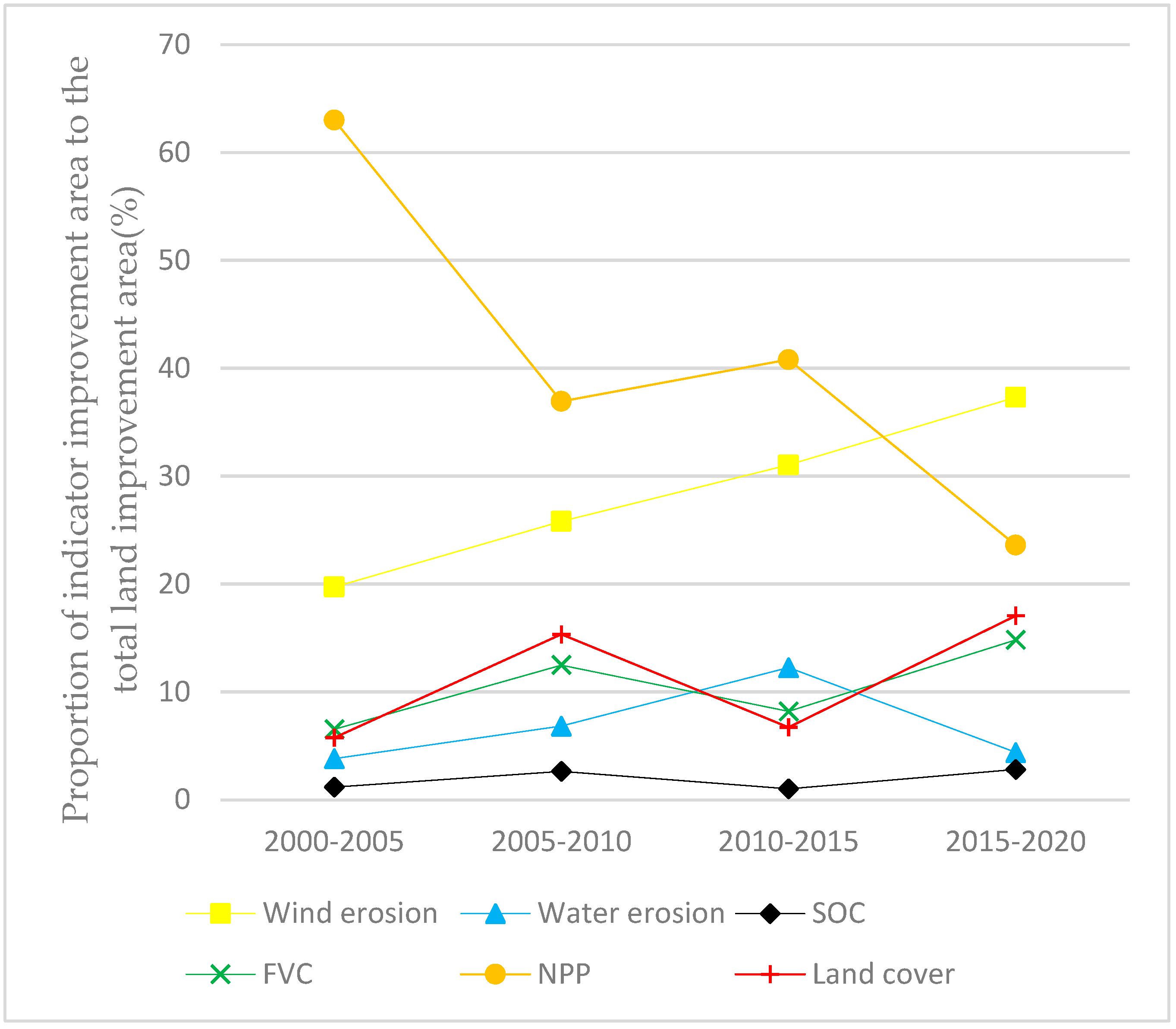

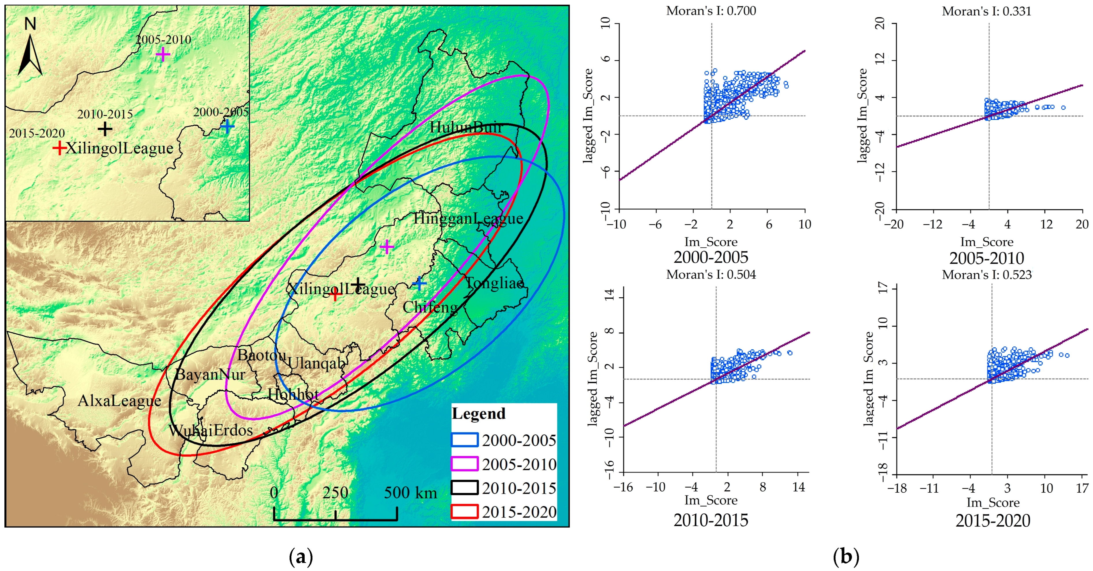
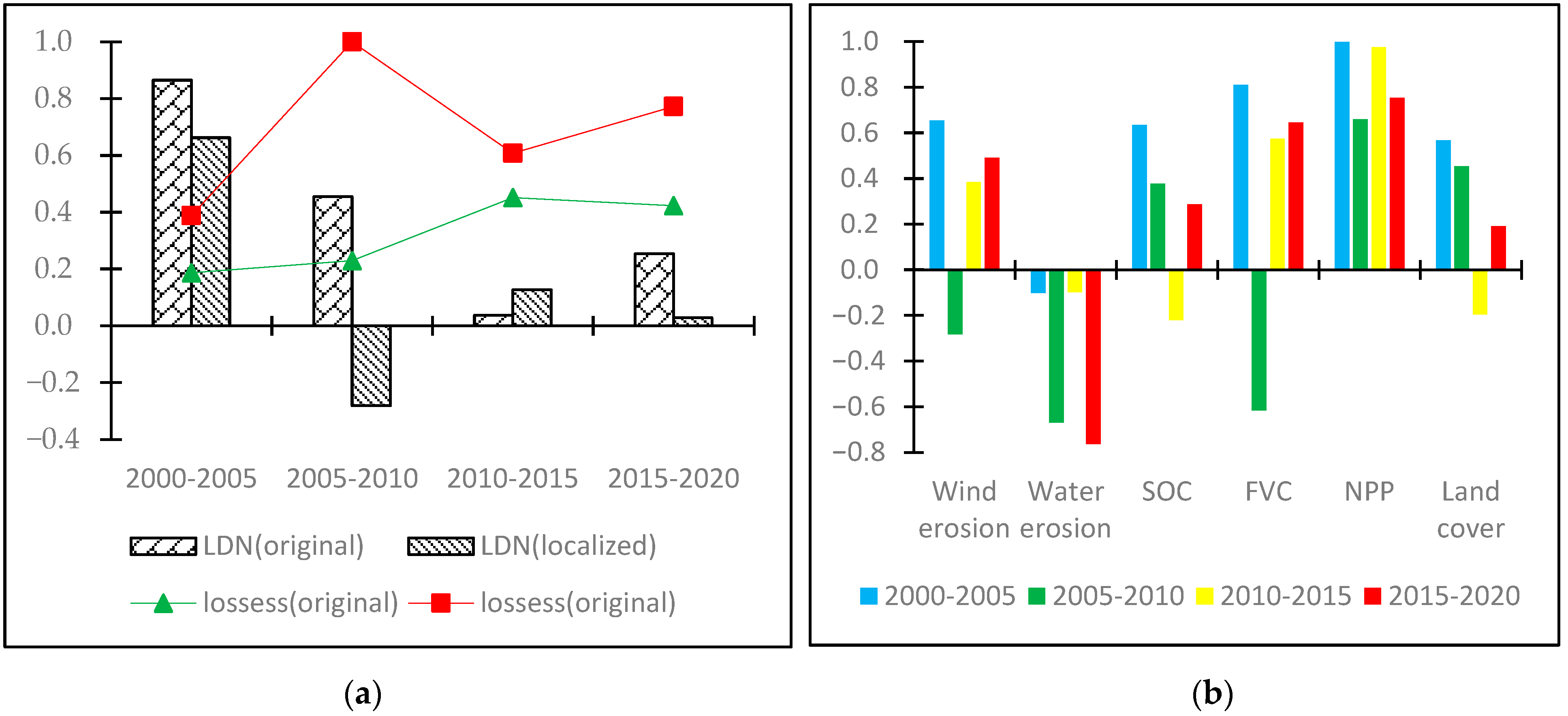


| Data | Resolution | Data Source | Collected Date |
|---|---|---|---|
| Land cover | 500 m | MODIS product (MCD12Q1) https://modis.gsfc.nasa.gov/data/dataprod/mod12.php (accessed on 4 July 2022) | 4 July 2022 |
| NPP | 500 m | MODIS product (MOD17A3HG) https://lpdaac.usgs.gov/products/mod17a3hgfv006/ (accessed on 11 May 2022) | 11 May 2022 |
| EVI | 250 m | MODIS product (MOD13Q1) https://lpdaac.usgs.gov/products/mod13q1v006/ (accessed on 5 July 2022) | 5 July 2022 |
| Snow depth | 0.25° | Long-term series of daily snow depth dataset in China (1979–2021), Cold and Arid Regions Sciences Data Center at Lanzhou (http://westdc.westgis.ac.cn) (accessed on 16 June 2022) | 16 June 2022 |
| Climate | - | China National Climate Center http://data.cma.cn/ (accessed on 2 June 2022) | 2 June 2022 |
| Soil properties | 1000 m | Harmonized World Soil Database v 1.2 https://www.fao.org/soils-portal/soil-survey/soil-maps-and-databases/harmonized-world-soil-database-v12/en (accessed on 14 June 2022) | 14 June 2022 |
| Soil Nutrient Levels | SOM Stocks (g/kg) | SOC Stocks Levels |
|---|---|---|
| 1 | >40 | 0 |
| 2 | 30–40 | 1 |
| 3 | 20–30 | 2 |
| 4 | 10–20 | 3 |
| 5 | 6–10 | 4 |
| 6 | <6 | 5 |
| Level | Water Erosion Modulus, t∙km−2∙a−1 | Wind Erosion Modulus, t∙km−2∙a−1 | Soil Erosion Level |
|---|---|---|---|
| 1 | <200 | <200 | 0 |
| 2 | 200~2500 | 200~2500 | 1 |
| 3 | 2500~5000 | 2500~5000 | 2 |
| 4 | 5000~8000 | 5000~8000 | 3 |
| 5 | 8000~15,000 | 8000~15,000 | 4 |
| 6 | >15,000 | >15,000 | 5 |
| Land Cover | Final Class | |||||||
|---|---|---|---|---|---|---|---|---|
| Forest | Grassland | Wetland | Cultivated Land | Bare Land | Artificial Surfaces | Water Bodies | ||
| Original Class | Forest | 0 | 0 | 0 | −1 | −2 | −3 | 0 |
| Grassland | 0 | 0 | 0 | −1 | −2 | −3 | 0 | |
| Wetland | 0 | 0 | 0 | −1 | −2 | −3 | 0 | |
| Cultivated land | 1 | 1 | 1 | 0 | −1 | −2 | −3 | |
| Bare land | 2 | 2 | 2 | 1 | 0 | −1 | −2 | |
| Artificial surfaces | 3 | 3 | 3 | 2 | 1 | 0 | −1 | |
| Water bodies | 0 | 0 | 0 | 0 | 0 | 0 | 0 | |
| Assessment Object | Indicator | Weight |
|---|---|---|
| The degree of land degradation and improvement | NPP | 0.1489 |
| Land cover | 0.0910 | |
| FVC | 0.1274 | |
| Wind erosion | 0.1488 | |
| Water erosion | 0.2774 | |
| SOC | 0.2066 |
Disclaimer/Publisher’s Note: The statements, opinions and data contained in all publications are solely those of the individual author(s) and contributor(s) and not of MDPI and/or the editor(s). MDPI and/or the editor(s) disclaim responsibility for any injury to people or property resulting from any ideas, methods, instructions or products referred to in the content. |
© 2023 by the authors. Licensee MDPI, Basel, Switzerland. This article is an open access article distributed under the terms and conditions of the Creative Commons Attribution (CC BY) license (https://creativecommons.org/licenses/by/4.0/).
Share and Cite
Li, Z.; Wang, Y.; Dong, J.; Luo, X.; Wu, H.; Wan, Y. Assessment of Land Degradation at the Local Level in Response to SDG 15.3: A Case Study of the Inner Mongolia Region from 2000 to 2020. Sustainability 2023, 15, 4392. https://doi.org/10.3390/su15054392
Li Z, Wang Y, Dong J, Luo X, Wu H, Wan Y. Assessment of Land Degradation at the Local Level in Response to SDG 15.3: A Case Study of the Inner Mongolia Region from 2000 to 2020. Sustainability. 2023; 15(5):4392. https://doi.org/10.3390/su15054392
Chicago/Turabian StyleLi, Zhanxing, Yanhui Wang, Junwu Dong, Xiaoyue Luo, Hao Wu, and Yuan Wan. 2023. "Assessment of Land Degradation at the Local Level in Response to SDG 15.3: A Case Study of the Inner Mongolia Region from 2000 to 2020" Sustainability 15, no. 5: 4392. https://doi.org/10.3390/su15054392
APA StyleLi, Z., Wang, Y., Dong, J., Luo, X., Wu, H., & Wan, Y. (2023). Assessment of Land Degradation at the Local Level in Response to SDG 15.3: A Case Study of the Inner Mongolia Region from 2000 to 2020. Sustainability, 15(5), 4392. https://doi.org/10.3390/su15054392


