Article

The Impact of Changes in Anthropogenic Activity Caused by COVID-19 Lockdown on Reducing Nitrogen Dioxide Levels in Thailand Using Nighttime Light Intensity

by
Nutnaree Thongrueang
1,*,
Narumasa Tsutsumida
2 and
Tomoki Nakaya
1
1
Graduate School of Environmental Studies, Tohoku University, Sendai 980-0845, Japan
2
Department of Information and Computer Sciences, Graduate School of Science and Engineering, Saitama University, Saitama 338-8570, Japan
*
Author to whom correspondence should be addressed.
Sustainability 2023, 15(5), 4296; https://doi.org/10.3390/su15054296
Submission received: 22 December 2022 / Revised: 17 February 2023 / Accepted: 24 February 2023 / Published: 28 February 2023

Abstract

:
Coronavirus disease 2019 (COVID-19) was first identified in Wuhan, China and has since become a pandemic. Thailand’s first lockdown started in the middle of March 2020, restricting anthropogenic activities and inter-provincial traffic. There are few studies on the association between nitrogen dioxide (NO2) levels and human activity, primarily because of the difficulty in identifying the changes in anthropogenic activities at a high geographical resolution. Here, we have highlighted satellite-based nighttime light (NTL) as an indicator of anthropogenic activities and investigated the relationship between NTL and reductions in NO2 levels during Thailand’s first lockdown in 2020. We applied geographically weighted regression (GWR) to analyze the regional relationship between NTL and changes in NO2 levels during the first lockdown. Sentinel-5 Precursor satellite observation indicated that the NO2 levels decreased by 10.36% compared with those of the same period in 2019. The level of NTL decreased in most urban and built-up (31.66%) categories. According to GWR results, NTL and NO2 levels represent a positive local correlation around the country’s central, western, and northern parts and negative correlations in the peripheral regions. These findings imply that NTL observations can be used to monitor changes in NO2 levels caused by urban anthropogenic activities.

1. Introduction

Coronavirus disease 2019 (COVID-19) was first identified in Wuhan, China and has since become a pandemic affecting many countries [1]. As of 7 February 2022, there have been 394,381,395 confirmed cases of COVID-19 globally, including 5,735,179 deaths, according to the World Health Organization (WHO) [2]. Most countries implemented non-pharmaceutical interventions, including lockdowns, to reduce the risk of spreading the disease and to save human lives [3], which caused substantial reductions in air pollution levels in over 34 countries worldwide [4]. According to Patel [5], the NASA Earth Observatory revealed that the nitrogen dioxide (NO2) concentration decreased in early 2020, reaching a 10–30% reduction in 2020 compared with that in 2019 in eastern and central China. A reduction in air pollution was also detected in most countries during the pandemic [6,7]. Additionally, Kanniah et al. [7] reported that aerosol optical depth and NO2 concentration declined by 27–34% in urban areas of Malaysia and were not affected by seasonal biomass burning. Roy et al. [8] showed that among 19 studied cities in the southeast Asia region, Dhaka, Kathmandu, Jakarta, and Hanoi experienced the highest reduction in NO2 concentration by approximately 40–47% during the lockdown period of 2020 compared with that of the corresponding period of 2019.
The government of Thailand announced the first lockdown and its administration zoning starting at midnight in mid-March 2020, restricting 68 million citizens inside their homes (Figure 1 and Figure 2). There was a strict ban on the movement of people during this lockdown, facilities such as public transport, schools, colleges, and universities were shut down, and local business travel and non-essential activities were reduced. The government decided to enforce a full lockdown over the zone. For example, the maximum controls with extra restrictions in the zone limited movement by decreeing that people could not leave their homes from 22:00 to 04:00 local time (Figure 2) [9]. Anthropogenic, industrial, vehicular, and other commercial energy-consuming activities have been substantially reduced owing to the COVID-19 lockdowns [10], thereby decreasing air pollution in Thailand. After the first lockdown, the Pollution Control Department declared that environmental quality had improved in all ways, as transportation and economic activity had been temporarily stopped [11]. Furthermore, Thailand’s overall air quality index improved by 30% after the implementation of restrictions [12].
However, it remains unclear how the degree of the widespread occurrence of COVID-19 induced a reduction in anthropogenic activity resulting in the decrease of air pollution on a geographical scale. The difficulty lies in identifying the changes in anthropogenic activity at a high geographical resolution. One solution for this is to use nighttime light (NTL) imagery indicators, which can correlate with economic indicators, such as gross regional product, across a range of spatial scales [13]. Kovács [14] reported that there was a connection between the past emissions of NTL intensity and the relative change in NO2 concentration in metropolitan France. A clear reduction in urban light emissions and NO2 and aerosols was observed during the lockdown in Spain [15]. Xu et al. [16] revealed that NTL radiation in Asia decreased after COVID-19 lockdowns in cities, reflecting reduced anthropogenic activity levels, e.g., in commercial and residential areas [17]. Although NTL is widely used in studies of economic activity and natural disasters [13,18], there are limited studies on the association between air pollution and NTL during the COVID-19 lockdown period.
We focused on the NO2 concentration in the air for measuring air pollution in this study, because this is strongly linked to anthropogenic activities, including emissions released from transportation. Liu et al. [19] showed that air quality improved because of the reduction in vehicle usage and industrial production during COVID-19. During the pandemic, reducing fossil fuel-dependent activities such as industrialization and transportation resulted in a significant reduction in NO2 emissions [20]. Depending on the type of anthropogenic activity, the intensity of light emitted at night and its contribution to atmospheric NO2 concentrations may differ. In Thailand, the primary sources of NO2 production are from transportation, power generation, industrial activities, and biomass burning. The largest contributor to NO2 emissions in urban areas is transportation, primarily cars and motorcycles [21]. In rural areas, biomass burning, including agricultural burning and forest fires, is an important contributor to poor air quality [22]. Therefore, it is likely that the relationship between the changes in NTL and air pollution varies geographically. Hence, we employed geographically weighted regression (GWR) to examine the regionally varying association between the changes in NTL and air pollution in Thailand. We particularly highlight the relationships between the observations of NTL and NO2 in the air before the lockdown period in 2019 (pre-lockdown), and in 2020, when the first lockdown was implemented in Thailand to control the transmission of COVID-19.

2. Materials and Methods

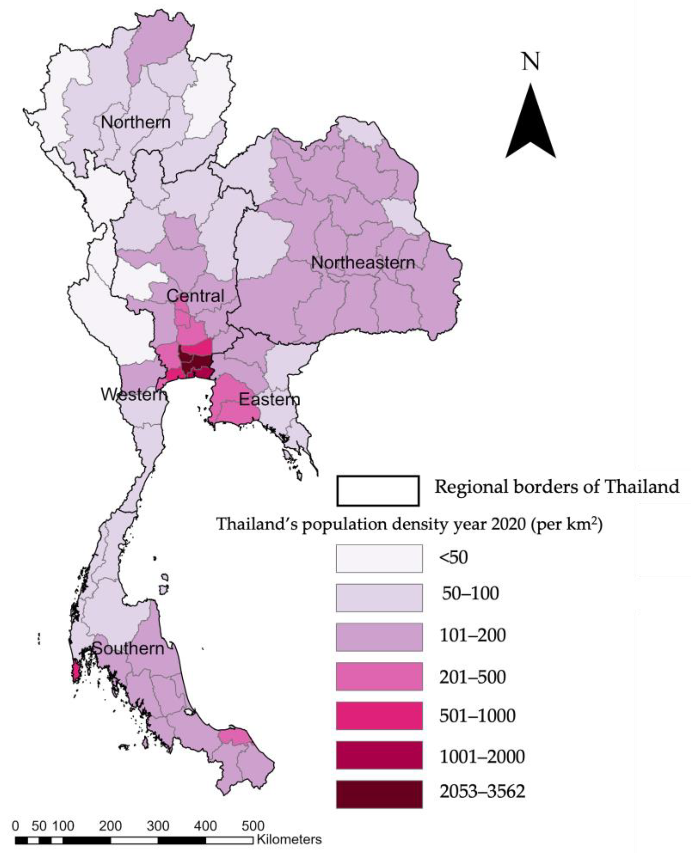
2.1. Data Sources and Preparation

NO2 data were derived from the Sentinel-5 Precursor (S5P) satellite observations. This is a single satellite mission and is a part of the Global Monitoring for Environment and Security (Copernicus) program launched by the European Space Agency to monitor air pollution [23]. The measurements are recorded using the TROPOMI instrument, which is the satellite’s single payload. It is a multispectral imaging spectrometer with a wide field of view that allows for global daily coverage and features a higher spatial resolution of 7 × 7 km2. TROPOMI enables the sampling of small-scale variabilities, specifically in the lower troposphere, and has potential for air quality research, thus making it suitable for monitoring the sources of emissions [24]. S5P level 3 Near Real Time from the Google Earth Engine (GEE) was used in this study. Liu et al. [25] used TROPOMI data to show that NO2 concentrations in urban areas of China and India were significantly higher than that previously estimated. The high levels of NO2 in Africa were shown by TROPOMI data to be caused by a large number of fires, particularly in the savannah and rainforest [26].
NTL intensity data were collected from the Suomi-NPP satellite observations. The Visible Infrared Imaging Radiometer Suite (VIIRS) supports a day/night band (DNB), sourced from the Suomi-NPP satellite of the NASA/National Oceanic and Atmospheric Administration, which provides multitemporal NTL data and allows for near-real-time monitoring because of its high repetition frequency [27]. The VIIRS sensor acquires data in a polar orbit, the appropriate time for observation in Thailand at around 00.00–00.30. For this study, we used the VIIRS Nighttime Day/Night Band Composites Version 1, which are monthly averaged radiance composite images. Composite stable data were obtained from the VIIRS-DNB data collected in 2019 and 2020 using the median reducer in the GEE to eliminate the maximum value of NTL. The average DNB radiance value was selected from the composite VIIRS-DNB data. We used the nearest neighbor resampling method in GEE for upscaling NO2 and NTL to 7 × 7 km2 grid cells.
Land cover data were obtained from the land-cover portal website maintained by SERVIR-Mekong. This system provides high-quality land cover information with multiple quality control sources. NO2 concentrations, NTL intensity, and land cover were processed using 7 × 7 km2 grid cells.

2.2. Estimation of Air Pollution Emission and Its Relationship with Anthropogenic Activities

For comparison, satellite-based NO2 concentrations and NTL measurements were calculated with regard to the median from 18 March to 30 June for both 2019 (before the lockdown period) and 2020 (during the first lockdown period) using the GEE platform and reported at a level of 7 km × 7 km grid cells. The changes in the NO2 concentrations between the pre-lockdown period in 2019 and during the lockdown period in 2020 were calculated.
Furthermore, the relationship between the changes in the NO2 and NTL data was explored using the GWR, a local spatial regression model (Equations (1)–(3)), to estimate the geographically varying coefficients and quantify the regionally varying effects of the reduction in anthropogenic activities on air pollutant concentrations during the pandemic outbreak phase across Thailand. We used a scalable variant of GWR for large datasets [28], which is available in the R package of the GW model [29]. We applied a logarithmic transformation because of the nonlinearity between NTL and NO2. The GWR model is expressed in Equation (1):
y i   = β 0 ( u i , v i ) + β 1 ( u i , v i ) x i   + ε i
where ( u i , v i ) are the coordinates (easting, northing) of point i .   y i and x i are the dependent and independent variables, respectively, which are defined as follows in Equations (2) and (3):
y i   = l o g N O 2 i , 2020   l o g N O 2 i , 2019  
x i   = l o g N T L i , 2020   l o g N T L i , 2019  
where l o g N O 2 i , 2019 and l o g N O 2 i , 2020   are the log-transformed NO2 concentrations for the lockdown period in 2019 (pre-lockdown) and 2020 (during lockdown), respectively; and l o g N T L i , 2019 and l o g N T L i , 2020 are the log-transformed average NTL intensity for the lockdown period in 2019 (pre-lockdown) and 2020 (during lockdown), respectively.

3. Results

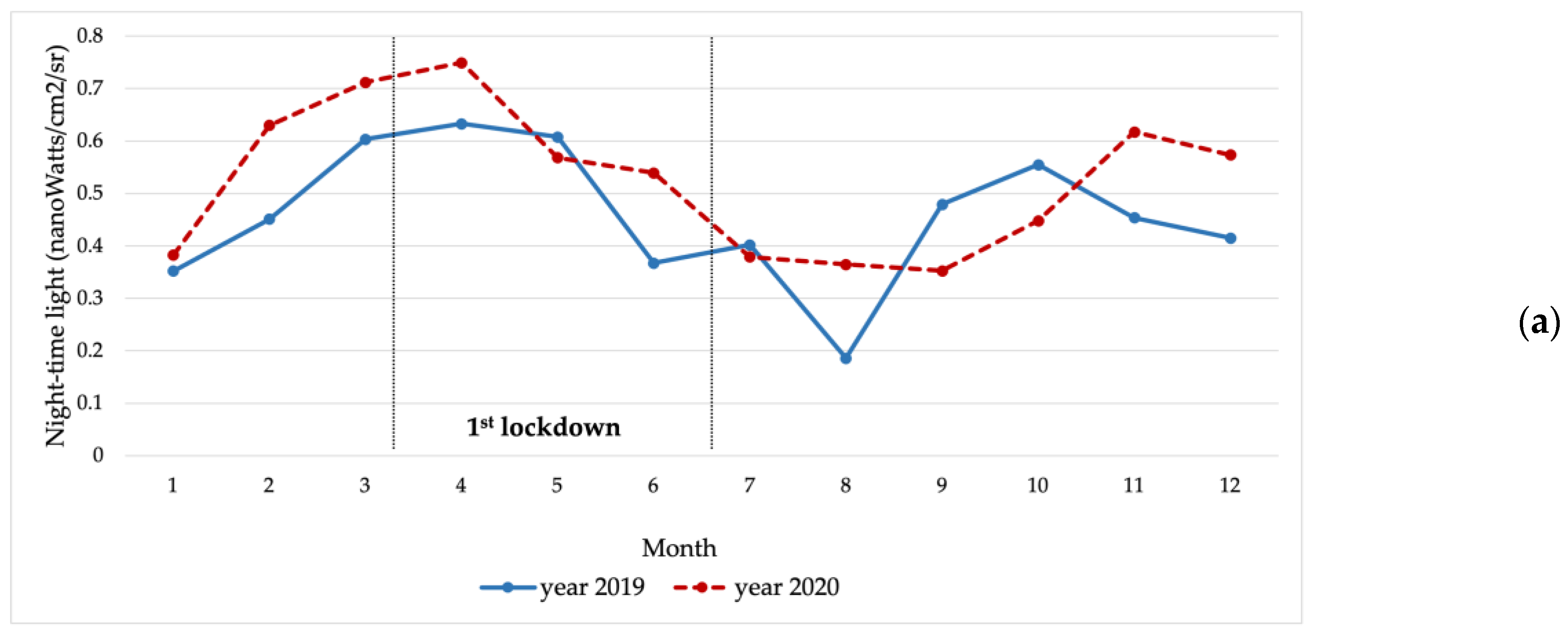
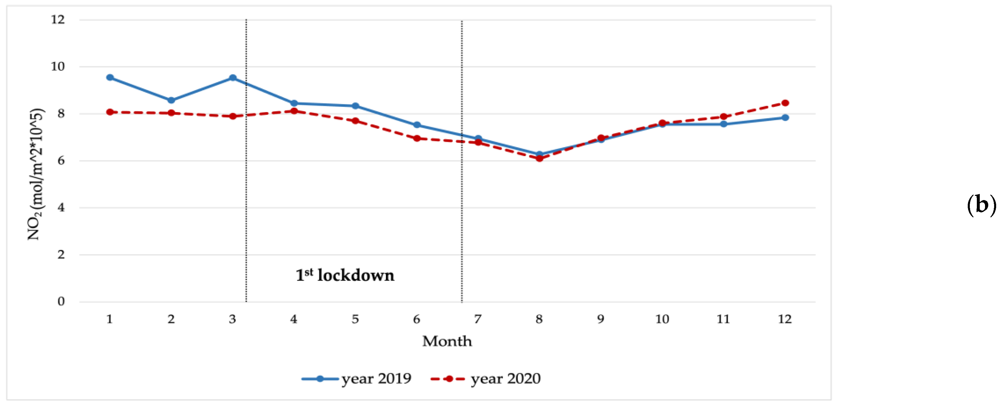
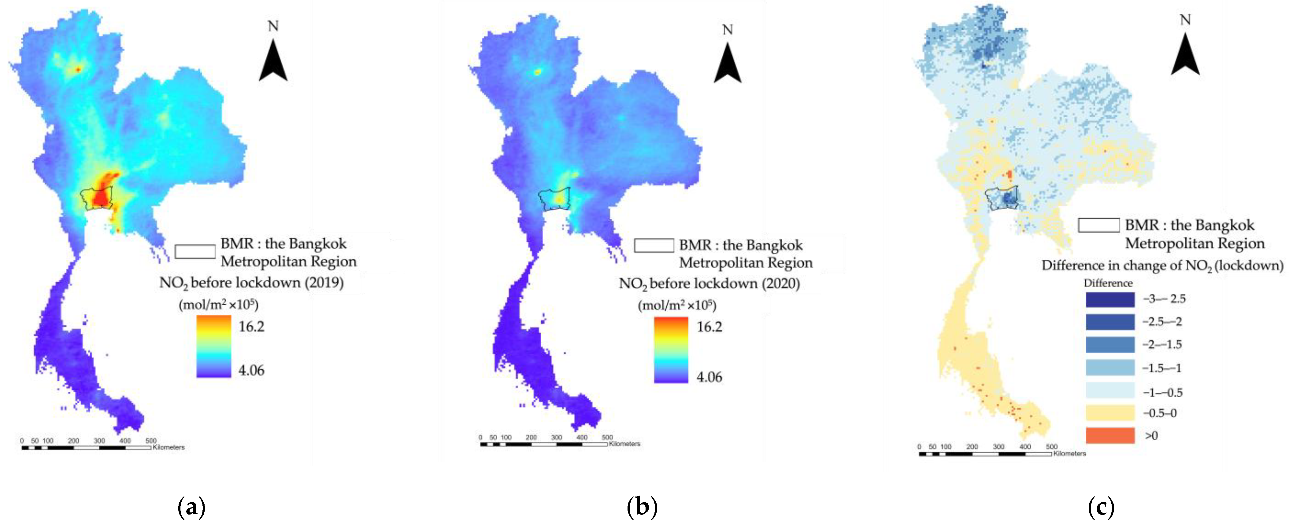
3.1. NO2 Level and NTL Intensity Change in Thailand

The comparison of monthly NO2 values (mol/m2 × 105) was of special interest for determining the overall change in the NO2 levels between 2019 and 2020 (Figure 3). Figure 3 shows the national monthly changes in NO2 and NTL, which in itself does not appear to show any noticeable lockdown-induced changes. This could be due to varying levels of lockdown restrictions, with some locations being less affected by the first lockdown, and an overall increase in NTL due to economic growth. On the other hand, the comparative changes in NO2 and NTL during the lockdown period are more pronounced in their geographical distributions (Figure 4 and Figure 5), indicating that the national monthly changes cannot capture the impact of the lockdown on NTL and NO2. Results revealed that the NO2 levels decreased by 10.36% during the first lockdown in 2020 (18 March 2020, to 30 June 2020) compared with those of the same period in 2019. The minimum, maximum, and average NO2 levels in 2019 were 4.06, 16.20, and 6.74 mol/m2 × 105, respectively (Figure 4a), whereas those in 2020 were 3.83, 13.49, and 6.04 mol/m2 × 105, respectively (Figure 4b). Although some reduction in NO2 levels was observed in the northern and northeastern parts, which are mountains covering dense forests, the reduction proportions of NO2 were most salient in the central part of Bangkok, comprising the primary shopping, dining, and nightlife hub areas (Figure 4c). Moreover, the comparison between the before- and during-lockdown period exhibited that the NO2 levels decreased in the northern, northeastern, central, western, eastern, and southern parts during the lockdown period compared with those of the same period in 2019.
A similar comparison of the monthly trends examined the overall change in the NTL intensity between 2019 and 2020 (Figure 3). The NTL intensity before and during the lockdown period revealed that the minimum, maximum, and average NTL intensities in 2019 were 0.001, 51.19, and 1.04 nW/cm2/sr, respectively (Figure 5a), whereas those in 2020 were 0.12, 49.40, and 1.09 nW/cm2/sr, respectively (Figure 5b). A large reduction in the NTL intensity was observed in the central part of Bangkok. Furthermore, the comparison between before and during the lockdown period exhibited that the NTL level slightly decreased in the eastern and northern regions, whereas it increased in other regions (Figure 5c).
Figure 5. Spatial distribution map of the change in nighttime light (NTL) intensity during the first lockdown period compared to that during the same period in 2019: (a) NTL before lockdown, year 2019 (18 March 2019 to 30 June 2019), (b) NTL during lockdown, year 2020 (18 March 2020 to 30 June 2020), and (c) difference in NTL change (lockdown).
Sustainability 15 04296 g005
Figure 6 presents the NO2 and NTL intensity reduction areas in different land cover categories of Thailand. These areas are grid cells in which the NO2 and NTL levels decreased over the same period in 2019 and 2020, i.e., the change was negative. As shown in Table 1, a large decrease in the NO2 level was observed in cropland, forest and mixed forest, and urban and built-up category areas, whereas a large decrease in the NTL level was observed mostly in urban and built-up areas. Urban and built-up areas cover approximately 31.66% of Thailand, and areas such as orchards or plantation forests and croplands cover 17.59% and 16.58%, respectively.
Table 1. Land cover types in NO2 and nighttime light intensity reduction areas.
Land Cover TypesNighttime Light (Decreased)NO2 (Decreased)
CountPercentage (%)CountPercentage (%)
Surface Water 21.01120.96
Mangroves 0000
Flooded Forest 0000
Forest 178.5433426.85
Orchard or Plantation Forest 3517.59624.98
Evergreen Broadleaf 84.02695.55
Mixed Forest 168.0425120.18
Urban and Built-Up 6331.66967.72
Cropland 3316.5836929.66
Rice 199.55252.01
Mining 0010.08
Barren 0000
Wetlands 10.5020.16
Grassland 10.50151.21
Shrubland 0020.16
Aquaculture 42.0160.48
Note: Count is the number of 7 km × 7 km grid cells.
Figure 6. Land cover types in (a) NO2 and (b) nighttime light intensity reduction areas.
Sustainability 15 04296 g006

3.2. Association between the NTL and NO2 Levels

We observed positive relationships between the log-transformed NTL and NO2 levels. The Pearson correlation coefficients between the variables were r = 0.33 for the pre-lockdown period in 2019 and r = 0.38 for the lockdown period in 2020.
Using the annual change in the log-transformed NO2 level as the dependent variable and log-transformed NTL as the independent variable, we fitted a GWR model to the data.
The distribution of the estimated coefficient of NTL ( β 1 ) in the fitted GWR model revealed that positive correlations were widely found in the central, western, and northern parts of the country, whereas negative correlations were observed in the peripheral regions (Figure 7). The R-squared value of the fitted GWR model was 0.592. This positive correlation means that NTL intensity decreased, and NO2 levels also decreased. In terms of the slope coefficient, if the coefficient is higher, it means NTL caused a more substantial reduction in air pollution reduction.

4. Discussion

During the lockdown period in Thailand, the percentage change in NO2 levels dropped by 10.36% compared with those of the same period in 2019. Furthermore, the difference in NTL substantially decreased around Bangkok and the surrounding areas during the lockdown. The GWR results showed that positive correlations between the NTL and NO2 changes were most strongly observed in urbanized areas, particularly the Bangkok Metropolitan Region (BMR). The central part of Thailand comprises various economic sectors, such as urban, industrial, agriculture, and tourism, with Bangkok being the major national economic sector. Furthermore, provinces in the central parts connected via a road network to Bangkok seem to have more traffic. The concentration of air pollutants during the dry season, from November to February, exceeds the air quality standards in Thailand. This changed with the implementation of COVID-19 lockdowns, which brought the movement of people close to a standstill by having them stay at home and work remotely. This reduced the inter-province traffic movement, resulting in a substantial reduction in the NO2 concentration and NTL intensity of this region. The results indicated that the reduction in anthropogenic activities in cities, reflecting the NTL change, substantially reduced the NO2 concentrations in the air around the cities.
However, it is necessary to be careful of the geographic context between the NTL intensity and NO2 emissions. We observed NTL intensity reduction in most urban and built-up areas (31.66%), orchard or plantation forest (17.59%), and cropland (16.58%) categories. The process of the decrease in NO2 in orchards, planted forests, and cropland areas is likely indirect. The primary cause of the decrease in NO2 during lockdown measures is likely the reduction in transportation and industrial activities due to restrictions on international movement and business operations, particularly in the BMR and its surrounding regions, which contain the agricultural land covers. The decrease in human activities in the urbanized areas may result in a decrease in emissions of NO2, causing the reductions in NO2 in the agricultural land covers near the BMR. It should be noted that approximately 30% of Thailand’s labor force is employed in agriculture [30]. Some of the people who work in the agricultural sector also reside in their agricultural lands. The source of NTL on plantation forests and cropland might have been generated by the daily activities conducted by the people who live there. Therefore, the results indicated that NTL reduction in the agricultural land use categories over Thailand was smaller than that in the urban and built-up areas, but NO2 decreased in the majority of cropland (29.66%), forest (26.85%), and mixed forest (20.18%) areas. In particular, NO2 has decreased in northern Thailand, which is non-urban and dominated by forests and cropland. This might be due to the fact that combustion in agriculture, such as burn farming, which characterizes this region [31], has also decreased due to the lockdown. However, the details of this process need to be further investigated.
Although NO2 concentration is linked to emissions generated by transportation, and these are common indicators of local air pollution exposure at various scales [32], there are some sources of NO2 emissions that do not originate from transportation and daily anthropogenic activities. In northern Thailand, power plants and forest fires emit NO2 into the air [16]. For example, the extreme air pollution emitted from the Mae Moh Power Plant in Lampang Province, Thailand, in 1992 and 1997 [33] adversely affected human health, property, animals, and plants in the surrounding area. According to the GWR results, the associations between the changes in NO2 levels and NTL data were estimated to be approximately zero or negative, and the NTL increased with reduced NO2 levels in 2020 compared to those in 2019 in the northern and northeastern parts of Thailand. This is possibly because of temporally activated emission sources with non-urban light, such as forest fires and burning of agricultural residues, producing relatively small NO2 emissions compared to those produced by vehicular exhaust and coal power plants, which are the primary sources of NO2 emissions in Thailand [34].
The impact of lockdown measurements has been observed in recent studies globally [35]. Including the second and third waves of the pandemic might provide a good understanding of the air pollution impacts caused by lockdowns. However, the general population has begun to exist alongside the pandemic and integrated various countermeasures into their everyday lives while being less afraid of the pandemic, unlike the situations observed during the first lockdowns. The first wave of lockdowns was thus the most stringent in its approach to the pandemic. The imposition of non-pharmaceutical interventions caused people to be extremely cautious while going outside or partaking in outdoor activities in public areas. During this period, a considerable reduction in air pollution was evaluated because of a substantial reduction in anthropogenic movement and activities. This was a type of natural experiment. It might be also better to consider much longer periods before 2019 to understand the natural fluctuations in NO2 in the atmosphere. As Thailand is a developing country, it is common for pollutant levels to fluctuate. Therefore, in this study, we focused on the changes in NO2 levels during the 2020 lockdown period, compared to the same period in 2019, particularly in urban areas, to gain a better understanding of such changes.
In future research, it may be better to use geographical detail mobility data, which may show a stronger relationship between anthropogenic activities and air pollution. However, they are quite expensive in Thailand and other developing countries and do not provide complete coverage of the whole area. Hence, although mobility data might be a possible option to measure human activity levels, they are not a reachable option under the current situation. Therefore, we used the NTL data. Moreover, we can apply the same method to other countries when using the NTL data. However, this study focused only on Thailand. Further studies can extend the study area by using satellite data, which can easily extend to other regions or the whole of Southeast Asia. Additionally, several challenging issues need to be resolved by gathering a more detailed analysis and understanding the role of meteorology over longer time periods.

5. Conclusions

This study presents the local correlation between NO2 and NTL during the first lockdown period in Thailand in 2020. Most urban and built-up areas saw a substantial decrease in NO2 levels and NTL compared to those recorded during the same time in 2019. According to GWR, the geographically local associations between the changes in NO2 and NTL were positive around the Bangkok metropolitan region. Our findings showed that reductions in urban anthropogenic activities, as reflected in the NTL in cities, are substantially related to reducing atmospheric NO2 concentrations. This result implies that in urban areas, NTL observations can be used to monitor changes in air pollution caused by urban anthropogenic activities.

Author Contributions

Conceptualization, N.T. (Nutnaree Thongrueang) and T.N.; methodology, N.T. (Nutnaree Thongrueang); software, N.T. (Nutnaree Thongrueang); formal analysis, N.T. (Nutnaree Thongrueang) and T.N.; data curation, N.T. (Nutnaree Thongrueang) and N.T. (Narumasa Tsutsumida); writing—original draft preparation, N.T. (Nutnaree Thongrueang); writing—review and editing, N.T. (Narumasa Tsutsumida) and T.N.; visualization, N.T. (Nutnaree Thongrueang). All authors have read and agreed to the published version of the manuscript.

Funding

This research received no external funding.

Data Availability Statement

Not applicable.

Acknowledgments

The first author gratefully acknowledges the MEXT (MONBUKAGAKUSHO) scholarship provided by the Japanese Government for conducting research at the Graduate School of Environmental Studies, Tohoku University and the support of the International Environmental Leadership Program of the Graduate School of Environmental Studies, Tohoku University.

Conflicts of Interest

The authors declare that they have no known competing financial interests or personal relationships that could have influenced the work reported in this study.

References

  1. Cucinotta, D.; Vanelli, M. WHO declares COVID-19 a pandemic. Acta Biomed. Med. Atenei Parm. 2020, 91, 157. [Google Scholar] [CrossRef]
  2. WHO. WHO Coronavirus (COVID-19) Dashboard. 2020. Available online: https://covid19.who.int/ (accessed on 12 June 2021).
  3. Hong, S.H.; Hwang, H.; Park, M.H. Effect of COVID-19 non-pharmaceutical interventions and the implications for human rights. Int. J. Environ. Res. Public Health 2021, 18, 217. [Google Scholar] [CrossRef] [PubMed]
  4. Venter, Z.S.; Aunan, K.; Chowdhury, S.; Lelieveld, J. Air pollution declines during COVID-19 lockdowns mitigate the global health burden. Environ. Res. 2021, 192, 110403. [Google Scholar] [CrossRef]
  5. Patel, K. Airborne Nitrogen Dioxide Plummets Over China. Available online: https://www.earthobservatory.nasa.gov/images/146362/airborne-nitrogen-dioxide-plummets-over-china (accessed on 8 April 2021).
  6. Doi, H.; Osawa, T.; Tsutsumida, N. Assessing the potential repercussions of the COVID-19 pandemic on global SDG attainment. Disco. Sustain. 2022, 3, 1–11. [Google Scholar] [CrossRef] [PubMed]
  7. Kanniah, K.D.; Zaman, N.A.F.K.; Kaskaoutis, D.G.; Latif, M.T. COVID-19’s impact on the atmospheric environment in the Southeast Asia region. Sci. Total Environ. 2020, 736, 139658. [Google Scholar] [CrossRef] [PubMed]
  8. Roy, S.; Saha, M.; Dhar, B.; Pandit, S.; Nasrin, R. Geospatial analysis of COVID-19 lockdown effects on air quality in the South and Southeast Asian region. Sci. Total Environ. 2021, 756, 144009. [Google Scholar] [CrossRef] [PubMed]
  9. WHO. WHO Coronavirus (COVID-19) Thailand Situation Reports. 2020. Available online: https://www.who.int/docs/default-source/searo/thailand/2020-04-3-tha-sitrep-41-covid19-final.pdf?sfvrsn=9e14aebc_0.pdf (accessed on 15 August 2022).
  10. Jain, S.; Sharma, T. Social and travel lockdown impact considering coronavirus disease (COVID-19) on air quality in megacities of India: Present benefits, future challenges and way forward. Aerosol Air Qual. Res. 2020, 20, 1222–1236. [Google Scholar] [CrossRef]
  11. Pollution Control Department, 2021. State of Thailand Environmental Quality 2020. Available online: https://www.pcd.go.th/pcd_news/11873 (accessed on 8 November 2022). (In Thai).
  12. Kaewrat, J.; Janta, R.; Sichum, S.; Rattikansukha, C.; Tala, W.; Kanabkaew, T. Human Health Risks and Air Quality Changes Following Restrictions for the Control of the COVID-19 Pandemic in Thailand. Toxics 2022, 10, 520. [Google Scholar] [CrossRef]
  13. Doll, C.N.; Muller, J.P.; Morley, J.G. Mapping regional economic activity from night-time light satellite imagery. Ecol. Econ. 2006, 57, 75–92. [Google Scholar] [CrossRef]
  14. Kovács, K.D. Nighttime Light Emissions Explain the Decline in NO2 during a COVID-19-Induced Total Lockdown in France. Geogr. Tech. 2022, 17, 104–115. [Google Scholar] [CrossRef]
  15. Bustamante-Calabria, M.; Sánchez de Miguel, A.; Martín-Ruiz, S.; Ortiz, J.-L.; Vílchez, J.M.; Pelegrina, A.; García, A.; Zamorano, J.; Bennie, J.; Gaston, K.J. Effects of the COVID-19 Lockdown on Urban Light Emissions: Ground and Satellite Comparison. Remote Sens. 2021, 13, 258. [Google Scholar] [CrossRef]
  16. Xu, G.; Xiu, T.; Li, X.; Liang, X.; Jiao, L. Lockdown induced night-time light dynamics during the COVID-19 epidemic in global megacities. Int. J. Appl. Earth Obs. Geoinf. 2021, 102, 102421. [Google Scholar] [CrossRef] [PubMed]
  17. Shao, Z.; Tang, Y.; Huang, X.; Li, D. Monitoring work resumption of Wuhan in the COVID-19 epidemic using daily nighttime light. Photogramm. Eng. Remote Sens. 2021, 87, 195–204. [Google Scholar] [CrossRef]
  18. Zhao, X.; Yu, B.; Liu, Y.; Yao, S.; Lian, T.; Chen, L.; Wu, J. NPP-VIIRS DNB daily data in natural disaster assessment: Evidence from selected case studies. Remote Sens. 2018, 10, 1526. [Google Scholar] [CrossRef] [Green Version]
  19. Liu, Q.; Sha, D.; Liu, W.; Houser, P.; Zhang, L.; Hou, R.; Lan, H.; Flynn, C.; Lu, M.; Hu, T.; et al. Spatiotemporal Patterns of COVID-19 Impact on Human Activities and Environment in Mainland China Using Nighttime Light and Air Quality Data. Remote Sens. 2020, 12, 1576. [Google Scholar] [CrossRef]
  20. Jechow, A.; Hölker, F. Evidence That Reduced Air and Road Traffic Decreased Artificial Night-Time Skyglow during COVID-19 Lockdown in Berlin, Germany. Remote Sens. 2020, 12, 3412. [Google Scholar] [CrossRef]
  21. Stockholm Environment Institute. Air quality in Thailand. Available online: https://www.sei.org/wp-content/uploads/2021/02/210212c-killeen-archer-air-quality-in-thailand-wp-2101e-final.pdf (accessed on 12 January 2023).
  22. World Bank. Thailand—Environment Monitor 2002: Air Quality (English). Available online: http://documents.worldbank.org/curated/en/710411468778515943/Thailand-Environment-monitor-2002-air-quality (accessed on 12 January 2021).
  23. Veefkind, J.P.; Aben, I.; McMullan, K.; Förster, H.; De Vries, J.; Otter, G.; Claas, J.; Eskes, H.J.; De Haan, J.F.; Kleipool, Q.; et al. TROPOMI on the ESA Sentinel-5 Precursor: A GMES mission for global observations of the atmospheric composition for climate, air quality and ozone layer applications. Remote Sens. Environ. 2012, 120, 70–83. [Google Scholar] [CrossRef]
  24. Ialongo, I.; Virta, H.; Eskes, H.; Hovila, J.; Douros, J. Comparison of TROPOMI/Sentinel-5 Precursor NO2 observations with ground-based measurements in Helsinki. Atmos. Meas. Tech. 2020, 13, 205–218. [Google Scholar] [CrossRef] [Green Version]
  25. Liu, Z.; Ciais, P.; Deng, Z.; Lei, R.; Davis, S.J.; Feng, S.; Zheng, B.; Cui, D.; Dou, X.; Zhu, B.; et al. Near-real-time monitoring of global CO2 emissions reveals the effects of the COVID-19 pandemic. Nat. Comm. 2020, 11, 5172. [Google Scholar] [CrossRef]
  26. Van Der Velde, I.R.; Guido, R.; Van Der Werf, S.H.; Henk, J.; Eskes, J.; Pepijn Veefkind, T.B.; Ilse, A. Biomass burning combustion efficiency observed from space using measurements of CO and NO2 by the TROPOspheric Monitoring Instrument (TROPOMI). Atmos. Chem. Phys. 2021, 21, 597–616. [Google Scholar] [CrossRef]
  27. Elvidge, C.D.; Baugh, K.E.; Zhizhin, M.; Hsu, F.C. Why VIIRS data are superior to DMSP for mapping nighttime lights. Proc. Asia-Pac. Adv. Netw. 2013, 35, 62. [Google Scholar] [CrossRef] [Green Version]
  28. Murakami, D.; Tsutsumida, N.; Yoshida, T.; Nakaya, T.; Lu, B. Scalable GWR: A linear-time algorithm for large-scale geographically weighted regression with polynomial kernels. Ann. Am. Ass. Geog. 2020, 111, 459–480. [Google Scholar] [CrossRef]
  29. Lu, B.; Harris, P.; Charlton, M.; Brunsdon, C. The GWmodel R package: Further topics for exploring spatial heterogeneity using geographically weighted models. Geo-Spat. Inf. Sci. 2014, 17, 85–101. [Google Scholar] [CrossRef]
  30. Musikawong, S.; Jampaklay, A.; Khamkhom, N.; Tadee, R.; Kerdmongkol, A.; Buckles, L.; Khachasin, S.; Engblom, A. Working and Employment Conditions in the Agriculture Sector in Thailand: A Survey of Migrants Working on Thai Sugarcane, Rubber, Oil Palm and Maize Farms. International Labor Organization 2021. Available online: https://www.ilo.org/asia/publications/WCMS_844317/lang--en/index.htm (accessed on 20 March 2022).
  31. Yin, S.; Wang, X.; Zhang, X.; Guo, M.; Miura, M.; Xiao, Y. Influence of biomass burning on local air pollution in mainland Southeast Asia from 2001 to 2016. Environ. Pollut. 2019, 254, 112949. [Google Scholar] [CrossRef] [PubMed]
  32. Levy, I.; Mihele, C.; Lu, G.; Narayan, J.; Brook, J.R. Evaluating multipollutant exposure and urban air quality: Pollutant interrelationships, neighborhood variability, and nitrogen dioxide as a proxy pollutant. Environ. Health Perspect. 2014, 122, 65–72. [Google Scholar] [CrossRef] [Green Version]
  33. Pollution Control Department. Situation of Air Pollution in Decades on Thailand. 2000. Available online: http://www.pcd.go.th/public/Publications/print_report.cfm?task=report2543 (accessed on 30 August 2021).
  34. Greenpeace. Human Cost of Coal Power. 2015. Available online: https://www.greenpeace.or.th/Thailand-human-cost-of-coal-power/en.pdf (accessed on 15 February 2022).
  35. Menut, L.; Bessagnet, B.; Siour, G.; Mailler, S.; Pennel, R.; Cholakian, A. Impact of lockdown measures to combat COVID-19 on air quality over western Europe. Sci. Total Environ. 2020, 741, 140426. [Google Scholar] [CrossRef]
Figure 1. Population density of Thailand.
Sustainability 15 04296 g001
Figure 2. COVID-19 cases during the first lockdown per 1000 people and COVID-19 situation administrative zoning map (18 March to 30 June 2020).
Sustainability 15 04296 g002
Figure 3. Monthly trends of nighttime light (a) and NO2 (b) in 2019 and 2020 in Thailand.
Sustainability 15 04296 g003aSustainability 15 04296 g003b
Figure 4. Spatial distribution map of the change in NO2 levels during the first lockdown compared to that during the same period in 2019: (a) NO2 before lockdown, year 2019 (18 March 2019 to 30 June 2019), (b) NO2 during lockdown, year 2020 (18 March 2020 to 30 June 2020), and (c) difference in change of NO2 during lockdown, year 2020 (18 March 2020 to 30 June 2020).
Sustainability 15 04296 g004
Figure 7. Geographically weighted regression (GWR) estimates of the slope coefficient.
Sustainability 15 04296 g007
Disclaimer/Publisher’s Note: The statements, opinions and data contained in all publications are solely those of the individual author(s) and contributor(s) and not of MDPI and/or the editor(s). MDPI and/or the editor(s) disclaim responsibility for any injury to people or property resulting from any ideas, methods, instructions or products referred to in the content.

