1. Introduction
In Italy, since the enactment of the Landscape laws of 1939 (no. 1089 and no. 1497) and the subsequent National Town Planning Law no. 1150 of 1942, the relationship between the three categories “environment”, “territory” and “landscape” has characterized the political and urban planning debate, revealing a complexity attributable to problems of a hermeneutic, normative and technical–operational nature. These are three categories that do not coincide from a historical, normative and lexical point of view, which, nevertheless, occupy the exact same space [
1,
2]. More than 80 years have passed, and still the question is far from resolved. The relationship of reciprocity existing between the three aforementioned categories is neither a trivial nor rhetorical matter and has generated in the Italian context: (a) from an operational point of view, the separation of competent administrative areas to the detriment of an integrated model of action; (b) from a spatial point of view, a progressive deterioration of Italian landscapes, particularly urban landscapes, due to the progressive urbanization processes.
As suggested by several authors [
2,
3,
4,
5], attempts at recomposition and integration have been made. The very notion of “environmental cultural heritage” of the Franceschini Commission suggests a recomposition between landscape and territory in both administrative and planning terms, as it envisaged a forerunner form of consultation between the local Municipality, appointed to draft the Local Plan (known in Italy as Piano Regolatore Generale PRG), and Superintendencies for Culture Heritage that had the task of drawing up the declaration of environmental cultural heritage. Even the Galasso law (no. 431 of 1985), in the will of the legislator, moves in the wake of the recomposition of urban planning and landscape matters, taking advantage of the generality of the notion of environment.
Then it has suggested that the Regions adopt landscape plans or regional plans with specific consideration of landscape and environmental values. However, the attempts to harmonize the different sector plans express the legislator’s will to resolve the conflict between landscape protection and land use, as well as the connection between the 1942 Town Planning Law and the 1939 Landscape laws. From an operational point of view, this has translated into a problem of competences between the State, which has the institutional task of a unitary management of protection, and the Regions, which are entrusted with the competence in urban planning matters—a clash that has gradually intensified in the light of the laws on administrative decentralization, up to the recent reform of Title V of the Constitution of 2001. The constitutional reform of 2001 represented a real missed opportunity for the connection between the various public authorities responsible for territorial management. In fact, it proposes a separation between territorial government, which is the responsibility of the Regions, and protection of the environment and cultural heritage, which is the responsibility of the State; nor has it been a clarification of the various areas of competence, the term “government of the territory” proposed in the articulation of the reform. Just as controversial was, for Settis [
2], the role of the European Landscape Convention (ELC) in settling the issues at the center of the debate on the environment, territory and landscape. The excessive dilatation of the field of competence of the landscape to the entire territory has led to the inevitable assumption that “if everything is landscape, nothing is landscape” [
6], but at the same time it has underlined the need for coordination between the different subjects. It is worth noting that the European Landscape Convention was drafted with the explicit aim of establishing some fundamental concepts in the field of landscape, even in countries with a less articulated, complex and long-standing tradition of protection than ours [
2], even if its value as a reference framework and action in the field of landscape in a pan-European context is undoubted [
7,
8].
Starting from this controversial framework, the article aims to analyze some ambiguities in the application of the principles of the ELC in Italy. Specifically, these are the major elements of innovation introduced by the ELC, which means: on the one hand, the definition of landscape as “an area, as perceived by people, whose character is the result of the action and interaction of natural and/or human factors” [
9] and, consequently, the involvement of local communities in landscape planning processes; on the other hand, the “active” protection as an interaction between protection, planning and management of the entire territory [
7].
This document is organized in two parts. The contribution will begin by developing a theoretical framework to address the relationship between “environment”, “territory” and “landscape” in the Italian debate. The first part deals not only with the definitional attempts but focuses on the implications that the different perspectives open both on the value and operational front. As it is addressed in the article, the recognition of the role played by the landscape as an “inclusive third party”, with respect to planning issues, is undermined by the practices of concurrent planning that are developing in Italy. Consequently, the implementation of the ELC in the integrated approach of which it promotes is questioned by the empirical evidence. Secondly, we consider some of the theoretical and practical issues relevant to participation in landscape planning processes by questioning the concept of community. The theoretical argument introduces the case of the Oreto River, analyzed both from the point of view of the practices that have invested it and from the point of view of the communities that have had a say in defining its current structure. The extreme case presented interesting offers and contradictory perspectives on the concept of community and identity on which the ELC definition of landscape is based. The goal is to develop an argument that is generally applicable and not merely determined by particular circumstances, which allows full application of the ELC, even in controversial and marginal contexts where the landscape is struggling to find recognition in local communities as a common good [
10]. At the same time, the case study highlights the effects of the definition of ELC in landscape decision-making processes with particular attention to the role of inclusive third party played by perception in the relationship between communities and local authorities responsible for landscape planning.
2. Environment, Territory and Landscape in the Italian Debate
The reciprocity relationship existing between the three categories of environment, territory and landscape is the result of an evolution of the multiple meanings attributed over time, and from the different disciplines, to the different notions. As Gambino points out:
Each of these concepts has been revisited in disciplinary debates and reflections, often enriched with new meanings. [...] In particular, the three key concepts mentioned above have now reached such an interpretative latitude as to make them substantially good for all uses and interchangeable with each other, at the price of a conspicuous increase in confusion and the difficulty of comparison and interdisciplinary communication.
From this point of view, what seems to distinguish the Italian national debate is—as often happens—a sort of “descriptive anxiety” [
12]. As a consequence, the categories of environment, territory and landscape have been deepened in their theoretical formulation without making any progress in their practical application. However, it is precisely in the various definitional attempts that it is possible to grasp the links and divergences between the three categories, even in a design sense. The definitions of environment, for example, are based on the systemic approach and can essentially be traced back to two points of view:
The anthropocentric perspective is the prevailing one and the one that informs the ELC, while the ecocentric approach of the environment is relatively recent and appears in Italy, for the first time, in the acts of the Franceschini Commission of 1967, which also identifies the chorographic zones under the term “environmental cultural heritage”. However, the juridical recognition of the environment, as an asset to be protected in its ecological sense, took place starting from the 1970s and as a result of the international spread of environmentalist culture. In Italian practice, the ecocentric meaning of defense of ecosystems and environmental components has prevailed, which, however, tends to overlap with the landscape category in relation to complex systems, where aesthetic instances of a conservationist matrix and environmental requests of an ecological nature meet; that is, when the environment tends to be not only a product of nature but also of culture. Compared to the environment, the landscape category is much more complex and polysemous. A stimulating definition is the one proposed by Pier Carlo Palermo who—taking into account the different notions and contaminations between visions—interprets the landscape as a:
field of interactions of which every gaze and every project become part, contributing to modify the forms and inherited visions. It implies a non-formalistic idea of the project, as a selective and experimental exploration of the evolutionary possibilities inscribed in the context. Therefore, it brings into play a non-trivial idea of architecture and urban planning.
It is, consequently, the product of the interaction between a subjective and objective dimension, between reality and its representation. It is a notion resulting from processes of signification and appropriation that inevitably involve not only the individual but the entire community that is both producer and user of the landscape. The objective/subjective dualism, within which the definition of landscape oscillates, is the reason why the landscape is configured as an unstable category where the ambiguity keeps the meaning of the landscape open and metaphorical, favoring the search for new conceptualizations and new paradigms of relationships with the real world, rejecting the objectifying seductions of the earth sciences and of a certain historicism, and also, jointly, regressions to pure aestheticizing visibleism and to ascientific impressionism. It leads us to question the relationship between processes of representation and real processes [
11]. Landscape is, therefore, a plural concept with a strong semantic charge which, as Gambi states, “is born within and from the territory” [
14] (p. 102) and invests it entirely even in those parts where the traces of history or the environmental characteristics are less evident [
9]. At this point it is legitimate to ask what the territory is.
With the term territory, the urban and planning discipline has identified a circumscribed physical space, generally the result of a political-administrative division, organized on the basis of the needs of a society. As such, it was first interpreted as a neutral support for transformations and was subsequently enriched with contents relating to the interaction between human activity and physical space [
15]. In this respect, the territory acquires a dynamic and no longer stable and objective value linked to exclusively physical factors, which gives it a strong transformative tension in relation to social, economic, cultural interactions, etc. which are activated on it. Also in this case, we find an overlap between the concept of environment and landscape and that of territory. As evidenced by the different attempts at definition, there is an inescapable circularity between the three categories. Territory, environment and landscape are not synonyms, they are not coincident categories but strongly interrelated [
16]. If this affirmation is a fact acquired and recognized by the scientific debate, why is it slow to take off in Italy an integration between the three themes to which the terms refer? How is it possible that the demands of the environment and the landscape, if not in rare cases, have not been assimilated by the practices of physical planning? The reality is that we are facing a problem not of an interpretative nature; it is the political and administrative difficulties that paralyze any attempt to innovate practices. A recomposition of the three areas is needed, understood as project categories, capable of overcoming the separation of the competent areas in favor of an integrated model of action. The future of our territories is a challenge that calls into question both planning and the defense of landscape and environmental values. It is clear that we are faced with apparently opposing demands (transformation vs. conservation, integration vs. separation, etc.); however, it is in the recomposition of the opposing dyads, which characterize the debate on the subject, that the project’s ability to create added territorial value lies [
17,
18].
However, this requires an assumption, which cannot be evaded or overlooked, namely the fact that the space in which we live, be it environment, territory or landscape, is a collective good and must be treated as such. This does not necessarily mean harnessing the territory in the folds of protectionist policies. It means reinterpreting the various instances using the different options of the trade: from rigorous protection to the planning of evolutionary processes. This implies a rethinking of the fundamental values on which to build the territorial project. The difficulties that landscape planning has encountered, in fact, are not attributable only to technical or procedural problems but to the hierarchy of values that it implies, for which the public interest is paramount over the private interest [
2]. There is a lack of awareness of this from various points of view. Palermo argues that “expert knowledge has responsibilities” [
13] (p. 168), and the quality of public choices cannot be separated from the pursuit of the common good. It is no coincidence that the landscape has been included in the Constitution in art. 9, at the highest rank of reasons of public interest and protection, because it is in the constitution that political systems insert long-term choices, removing them from the risk of arbitrariness of the government in office [
19] and entrusting landscape with the capacity to remove obstacles to the full development of the human person [
20].
By extension we can say that the definition provided by the ELC moves in the wake of the art. 9 of the Italian Constitution. If we accept the hypothesis that the European Council is a “moral authority” [
21], the definition of landscape that comes from the ELC should be taken as a value guideline for setting up landscape planning in the Member States. As Butler and Berglund argue, “At the heart of the Landscape Convention is the definition of landscape: ‘an area, as perceived by people, whose character is the result of the action and interaction of natural factors and/or humans’ [
9]. Being recognized as a ‘people-perceived’ entity shifts the landscape’s focus from being a purely physical area to being dependent on individuals and society to provide it with meaning. This definition promotes landscape as a domain of society, providing a space for the democratization of landscape as a common resource” [
22]. p. 220
While acknowledging the value of the ethical–moral responsibilities introduced by this definition, as highlighted by Settis, the formulations are “quite vague and general” [
2] p. 254 and do not promote innovations “capable of protecting the Italian landscape better than what national and regional regulations do (or do not do)” [
2]. (p. 255) This formulation overcomes the conflicts between divergent domains (i.e., territory/environment/landscape) and places the landscape as a pivotal element on which to build political choices and projects for territories. At the same time, the expression “as perceived by people” concentrates innovations related to the democratization of landscape planning processes identifying the landscape as a space of empowerment and development of agency practices. Just as it has been noted:
Convention does not specify in a more precise way what is meant by ‘people’, whether the reference is to the resident populations, or to a wider set of users. Leaving aside the difficult question of the relationship between insiders and outsiders, it seems clear that the reference to the perceptive aspect orients the reading of the landscape in the current sense, in the immediacy of the collective representation of places. But the story is not perceived. The legacies of the past settled on the territories and the stratifications of anthropic presence cannot be reduced to a mere perceptive phenomenon.
The recognition of the identity and value of places are central issues and rightly intersect with the role and “awareness” of local communities, historically it has not been extraneous to the processes of transformation/alteration of the territory and the landscape. The prevalence of perception (and of interest), which is an individual action, obscures, and in many cases overwhelms, the collective interest. This is an ethical issue of fundamental importance, which is at the basis of both the national and international debate on the landscape and which highlights the critical points of the definition itself provided by the ELC. If the normative vision, linked to a strong thought, subtracts territorial resources with a high cultural or environmental value from the arbitrariness of subjectivity, the perception on the other hand induces, once again, to wonder about the concept of community and to ask some questions. Which community and which identity are represented by the landscapes referred to by the ELC? Or again, who is entitled to represent communities in landscape planning processes? What interests and what values do the communities involved convey? These are just some of the questions that guided the construction of the case study and that seek to address the most controversial aspects of the ELC. The central purpose of the case study is to raise and illustrate some due ethical dilemmas that the ELC raises whose aims and attempts are to carry out a collaborative planning approach in a rather uncooperative place, such as Palermo. The non-collaborative nature of our society and institutions in relation to planning is well described by Brand and Gaffikin [
24]. In some local contexts (such as those described here), there are further elements (due to the characteristics of the political regime as well as the structure of society) that deepen the non-collaborative nature of planning policies [
25]. As Oles and K. Hammarlund observe, the “ELC does not acknowledge the possibility of destructive or destabilizing local actors at all” [
26] p. 476 as it does in contexts such as Italy where political accountability, lawlessness and citizen participation take on blurred and contradictory contours. And if in principle ELC democratizes landscape planning, it is through a critical reading of the specific case that its practical usefulness can be measured. From these premises, the case study below highlights not only the contradictions in the context in land use and values attributed to the territory but also the limitations and difficulties involved in applying the principles of the ELC [
21].
3. Observing the Specific Case: The Oreto River in Palermo, Sicily (IT)
The article observes this crucial dimension through a specific case study within the city of Palermo, in northwestern Sicily, and it concerns the complex situation of the Oreto River. The article chooses to describe the case of Palermo as identifiable as an “extreme case”, i.e., as a necessary case in order to obtain information from an unusual case, which can be particularly problematic [
27,
28]. The case of Palermo presents certain characteristics of exceptionality such as warranting the choice of its specific description. On the one hand, it is a very extensive city facing the Mediterranean that plays the administrative role of regional capital, presenting a vast historical and architectural heritage; on the other hand, it is a city with considerable conditions of marginality (geographical, economic and social), coupled with a context of repeated difficulties in the application and realization of urban planning forecasts and the creation of collaborative practices. The relationship between the Oreto River and the city thus becomes peculiar to understanding the complexities in the application of ELC.
The process that will be set out within this paragraph starts from the geographical and naturalistic framework of the case analyzed; it then proceeds through the understanding within the evolution of the territory in which the river flows (both rural and urban). This leads to a brief excursus of the urban planning instruments that have determined the actual situation. Furthermore, a mapping of the most relevant actors operating in relation to the Oreto River is envisaged, concluding with the construction of meaning within which the analyzed case study is emblematic for the proposed theme.
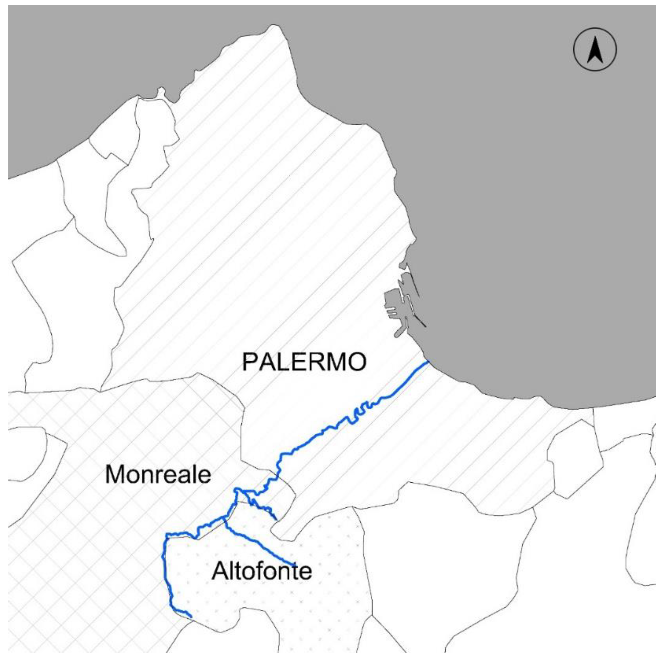
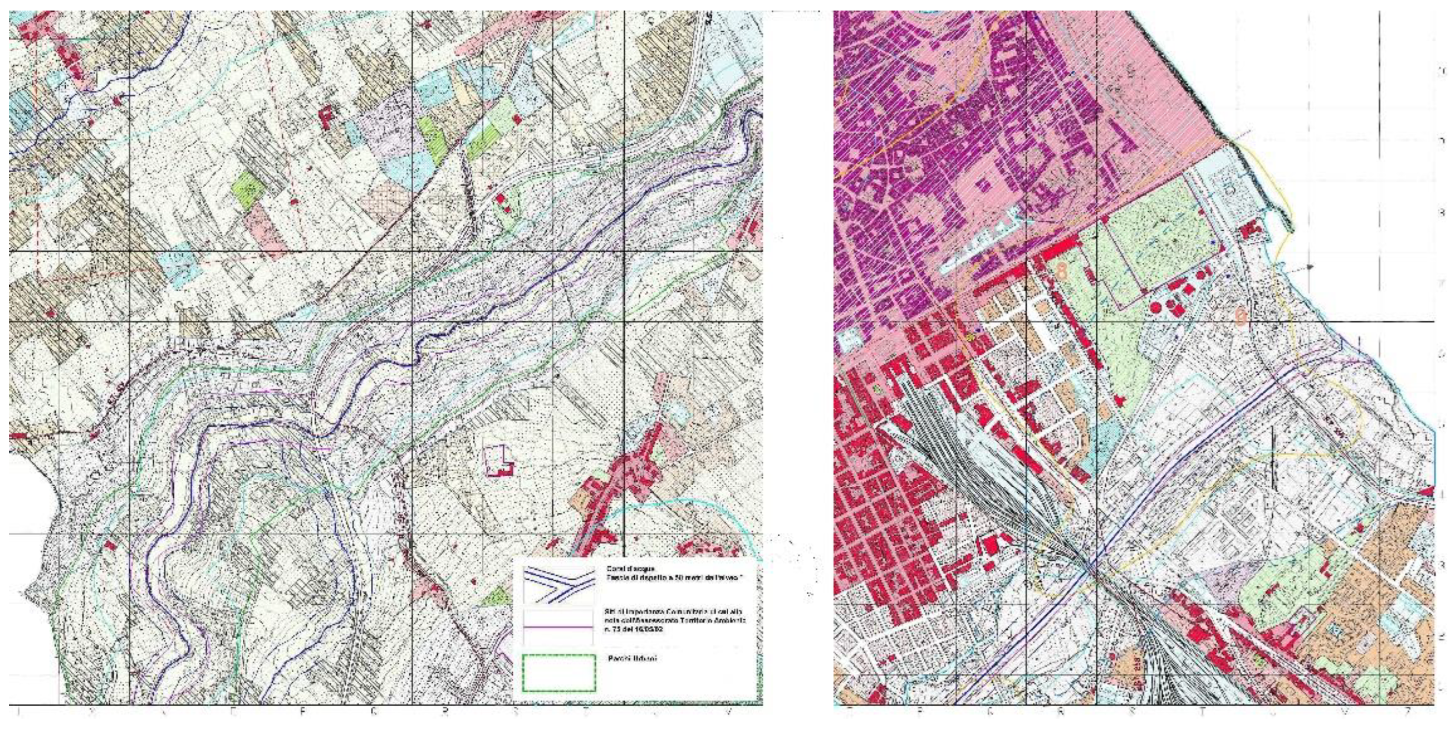
The Oreto river emerges from the slopes of Mount Matassaro Renna (mountains located in the Metropolitan City of Palermo) and flows through three municipalities (Altofonte, Monreale and Palermo) in a meandering riverbed until it penetrates the urban fabric and flows into the Tyrrhenian Sea (
Figure 1). The watercourse is part of the municipal Natura 2000 network, and it is recognized as a Site of Community Importance, SCI ITA020012 (Oreto River Valley, 20 km long and 6 km wide), identifying the naturalistic-environmental, floristic and faunal value of the biotope [
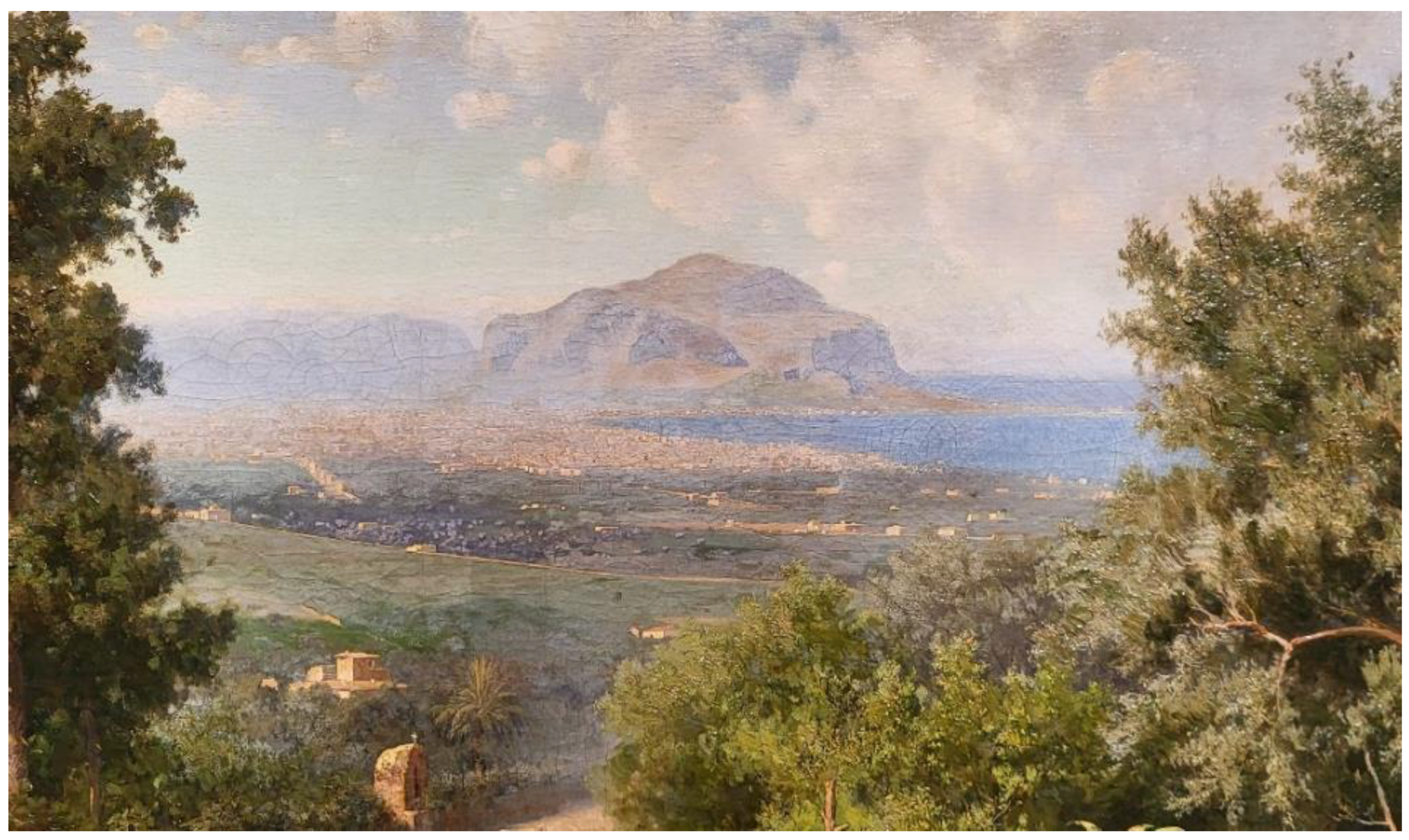
29]. According to article 6 of the Habitats Directive, sites designated as SCIs and SPAs (Special Protection Areas) must be subject to particular conservation measures for the natural habitats where animal and plant species are present. In the first kilometers from the source of the Oreto River, in fact, there is a high naturalistic level, but as we progressively approach the mouth, the landscape—and consequently the environmental and contextual conditions—deteriorates considerably. The urbanization of the countryside, developed from the 1970s, together with the phenomena of unauthorized building continues to aggravate the conditions of naturalistic degradation of the landscape through which the Oreto River flows, accelerating the negative transformations of what remains of the “Conca d’Oro” area: the historical countryside that has inspired painters who have traveled the island for centuries (
Figure 2).
On the one hand, this has led to the disappearance of riparian and forest habitats that were once widespread and diversified along the course of the Oreto [
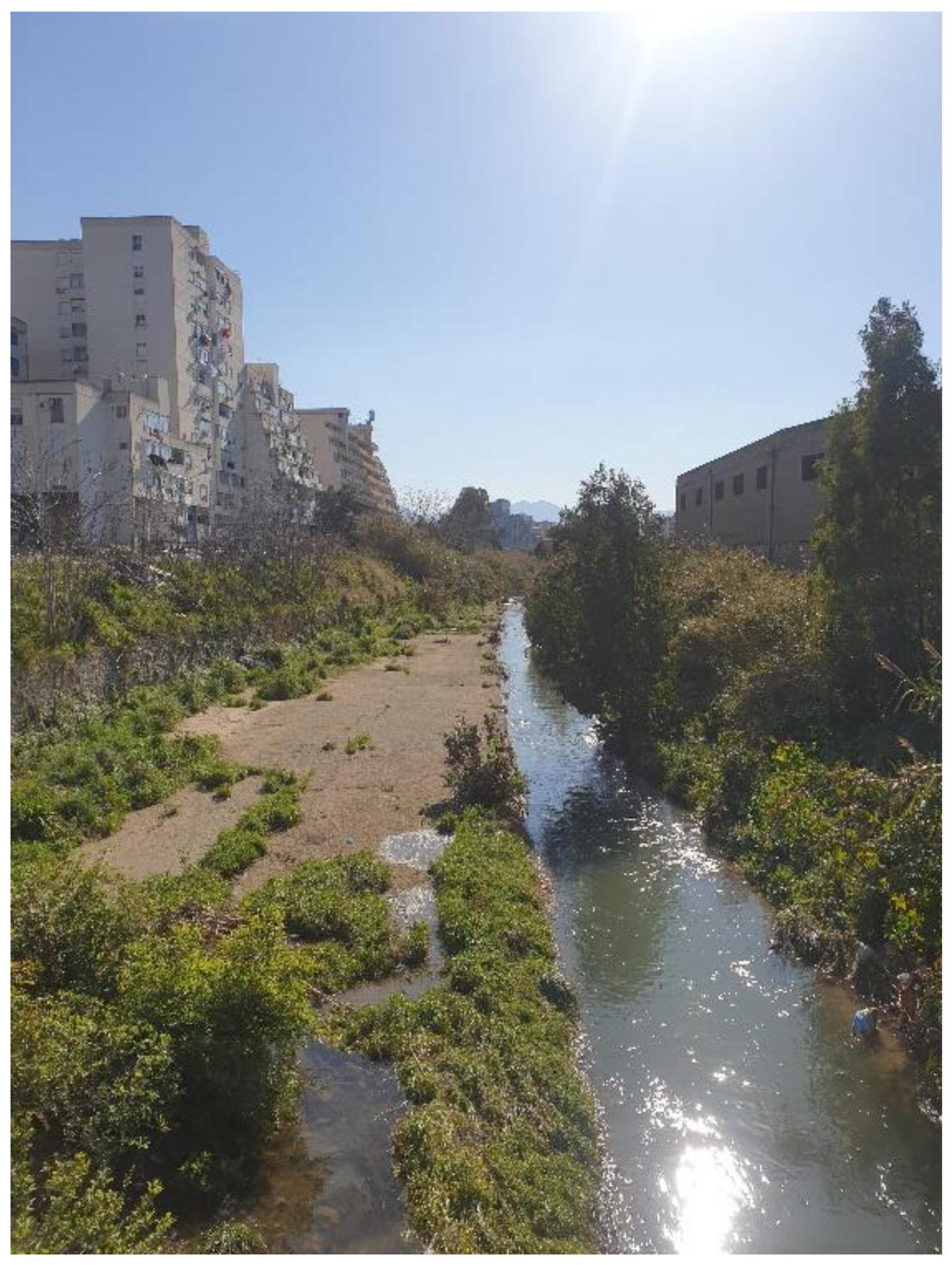
30]; on the other hand, the river landscape is the result of a rejection of urban production that exerts strong anthropic pressure on the natural system. This condition of degradation of the environmental system has been accentuated since the 1960s by the discharge at the mouth of the Oreto of soil and waste building material that over time has assumed such dimensions as to modify the coastline (today characterized by the presence of Foro Italico, a linear park along the coast facing the historic center).
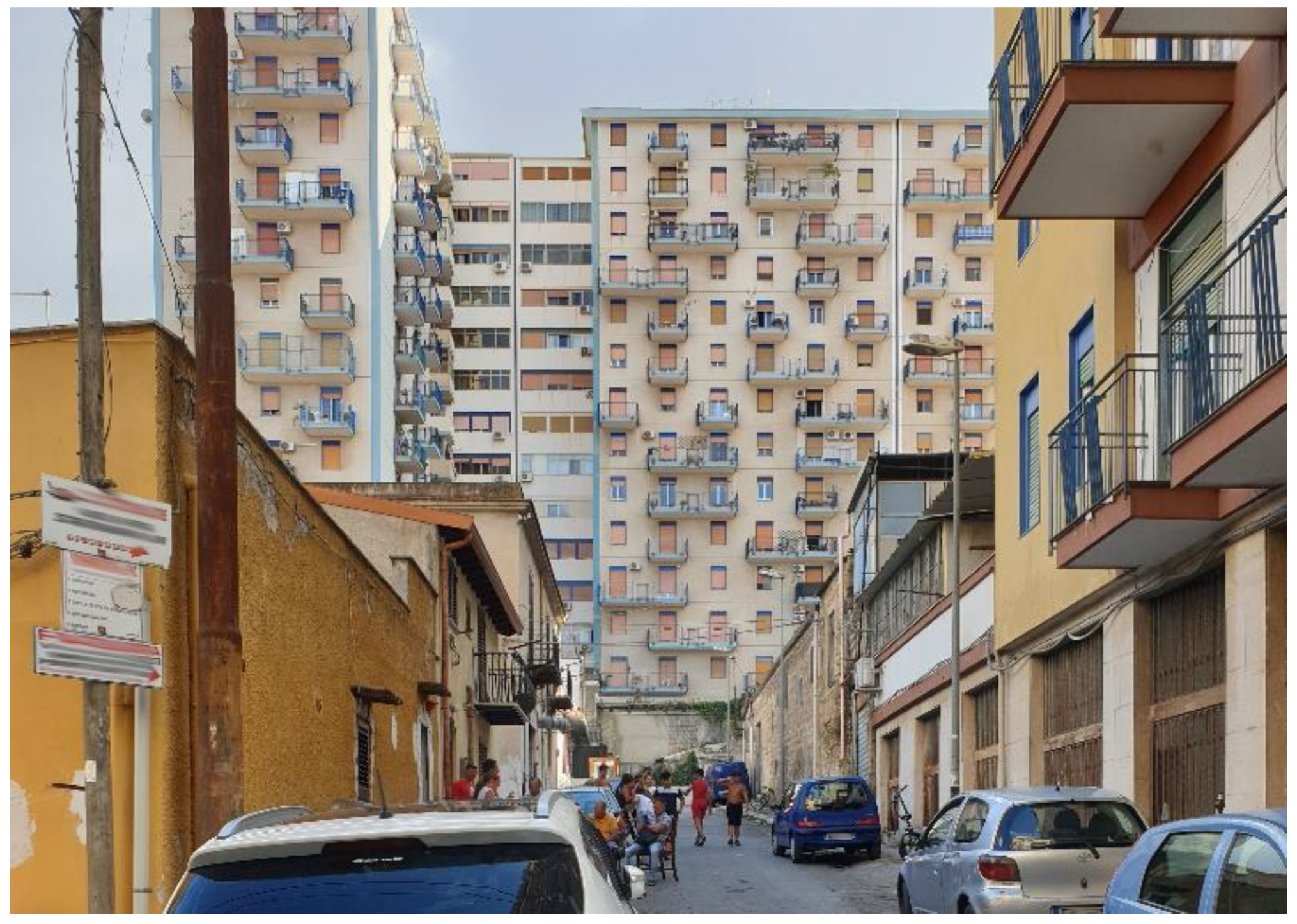
While rivers have been a source of great wealth for cities in their formation and development, in the Italian context over the last century, there has been a negation of watercourses, which have remained marginal in urban landscape planning and design processes. In the case of Palermo, there has historically been no direct, symbiotic relationship with the Oreto River. In fact, excluding the presence of historic mills, a few churches, monasteries or convents in the strip between the city and the river, the area has always had an agricultural vocation [
31]. During the expansion of the city towards the south, the river has been a completely passive element, being overwhelmed by cementification (
Figure 3).
In recent decades, in a national panorama of recovery of the relationship between the city and the natural elements present in urban areas, attempts are being made to rethink the connection with rivers, no longer seen as limits but as new opportunities: This is also happening in Palermo.
At the regulatory level in Italy, river courses and wooded areas are protected by law no. 431 of 1985; thus rivers, watercourses and streams and their banks for a strip of 150 m each are bound by the aforementioned law. This was transposed into Legislative Decree no. 42 of 2004, in the art. 142 of the Codice Urbani. Furthermore, it is important to underline that, in the final stretch of the Oreto River, there are areas identified in the Regional Hydrogeological Structure Plan with moderate and high flood hazard; the areas identified by the plan should be subjected to a recovery action for the defense of hydrogeological risk. As emphasized by Pinzello [
32], planning for a river does not concern the municipal level but a supra-municipal dimension that can take into account, beyond administrative limits, morphological and territorial characteristics. However, it is useful for the argumentation of the thesis presented in the article to focus on the urban dimension of the problem. To date, the most complex stretch of the river corresponds to the last few kilometers before the mouth, where the densest urban fabric is crossed (
Figure 4).
Moreover, it is regarding this stretch that the attention of the recently intercepted investments is directed, which envisage the redevelopment of the last few hundred meters through the proposal of a park in direct connection with the Foro Italico (mentioned above). Thus, a brief overview of the city’s planning process is proposed, starting from the mid-19th century, when the first expansions of the walled city began.
Throughout its evolution, the city’s prevailing direction has been northwards, apart from historical suburbs, such as Brancaccio, Guadagna, Settecannoli or the Romagnolo coastline. This was also due to the presence of the Oreto River, whose torrential nature made it difficult to physically overcome it towards the southern part which, due to the very presence of the Oreto River, was considered a fairly unhealthy area [
33]; for these reasons, the slaughterhouse and cemetery were located there. In 1889, the PRG edited by the engineer Felice Giarrusso was drawn up, where precise indications were not provided for the area south of the Oreto River, defining a subdivision up to the Botanical Garden and Villa Giulia. In early 20th century planning, little attention was paid to the development of the city towards the south. Twenty years later, following the Second World War, in 1947, the outline of the Reconstruction Plan of the Municipality of Palermo was approved. In regulating the reconstruction of the areas damaged by the war, the expansion of the city was also regulated. In the Brancaccio area, intensive building zones were foreseen, as well as the presence of industrial areas and the presence of rural areas. In 1959, when the Municipality of Palermo’s Local Plan was approved, Italy was experiencing subsidized building under the Fanfani, Tupini and Aldisio laws that, in order to meet post-war housing needs and prevailing national unemployment, led to a sprawl of the city. The PRG of the municipality of Palermo of 1962, within which the “Sacco di Palermo” was perpetuated, determined the approval in 1966 of the Plan for economic and social housing (Piano per l’edilizia economica e popolare, PEEP) in areas that were previously intended for agricultural use located at a considerable distance from the urbanized center and consequently from the services. This plan, which cannot only be defined as insensitive to the problems of protecting the historical and artistic heritage of the city, providing for operations to replace the 19th century building fabric with multi-story buildings, but also from the point of view of natural and environmental resources, seeing the territory as a unique resource for the expansion of urban settlements. The PEEPs built in the southern part of the city have generated neighborhoods that are increasingly marginalized from the rest of the urban context, with a homogeneity of economic and social class accentuated by the structural lack of public services and welfare state.
The current PRG, initiated by Mayor Leoluca Orlando, the variant of which was proposed by the architect Pier Luigi Cervellati and approved in 2004, complies with the national law on urban planning standards D.M.1444/68. The plan shows great attention to the environmental resources of the remaining Conca d’Oro and proposes the creation of the agricultural park of Ciaculli. Within the plan, the Oreto River is identified as a park (zone V2/V3 “public green spaces”), which has not yet been created (
Figure 5).
In 2015, the process of drafting the new PRG “Palermo 2025” began, but nowadays, it is available just as a master plan version. Here, the intention is manifested to enrich the environmental system of the city with various urban ecological corridors, including the Oreto River, the mouth of which is identified as an “urban regeneration area”.
From this brief excursus, one can understand the aforementioned passivity of the river in urban planning events, if not in more recent intentions. Moreover, although the river has been identified since the 2004 PRG variant as a park, it has neither been undertaken with environmental restoration policies nor realized.
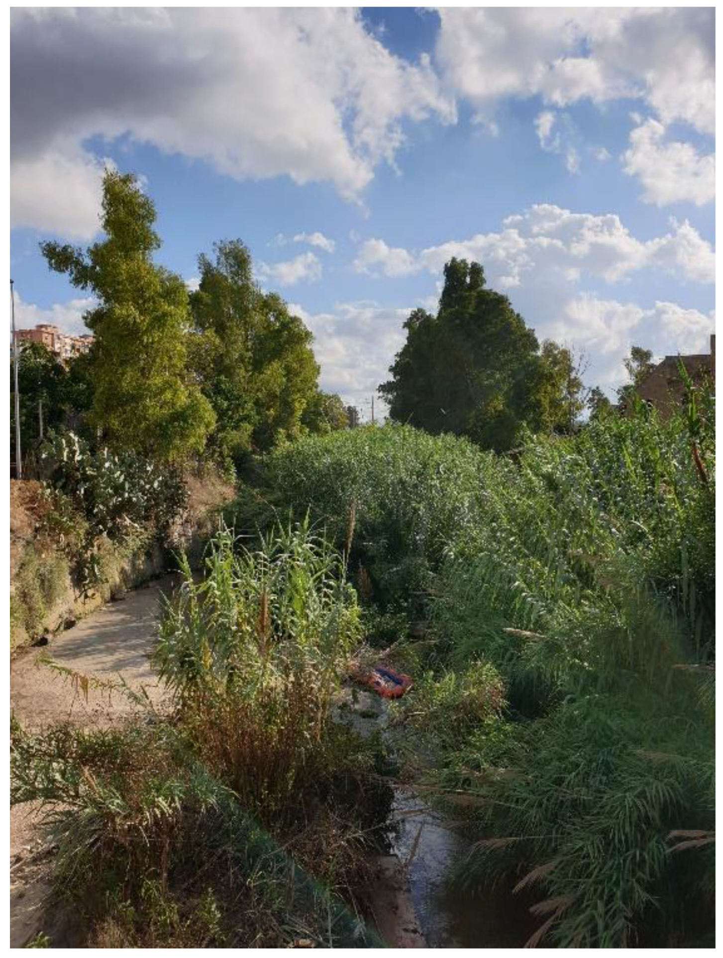
Following this brief urban planning framework, it is useful to look at the current socioeconomic and territorial context. The city of Palermo is characterized by an urban context comparable to that of other southern European coastal cities bordering the Mediterranean. The economic and social dimensions within the city are quite divergent: There is a shift from areas that are very well cared for and where the welfare system is operational and remarkable to areas characterized by pockets of poverty where unemployment and school drop-outs predominate and where there is a structural lack of services. Since the 1970s, urban expansion has also characterized the southern part of the city. The mutations essentially all occur before 2000, almost completely saturating the territory in the space of 30 years. Agricultural activity is currently present only in the area of Ciaculli (which together with the Oreto River, the Fossa della Garofala and the Parco della Favorita is one of the largest green areas of the city) and Croce Verde. Thus, the Oreto River, which has a torrential character and describes evocative meanders in the alluvial plain, now enters the denser settlement fabric through a linear regimentation of its course in a concrete bed, according to a route almost perpendicular to the coastline. This channeled river rod that precedes the mouth is currently heavily degraded. The building fabric that is grafted along the course of the river is characterized by phenomena of unauthorized use and by a disorderly growth of the city; moreover, the regimentation within a cemented course and the dysfunction of the sewage system that conveys the wastewater of three municipalities into the riverbed have led to a drastic loss of ecological quality and consequently urban one, generating phenomena of social isolation [
34] (
Figure 6).
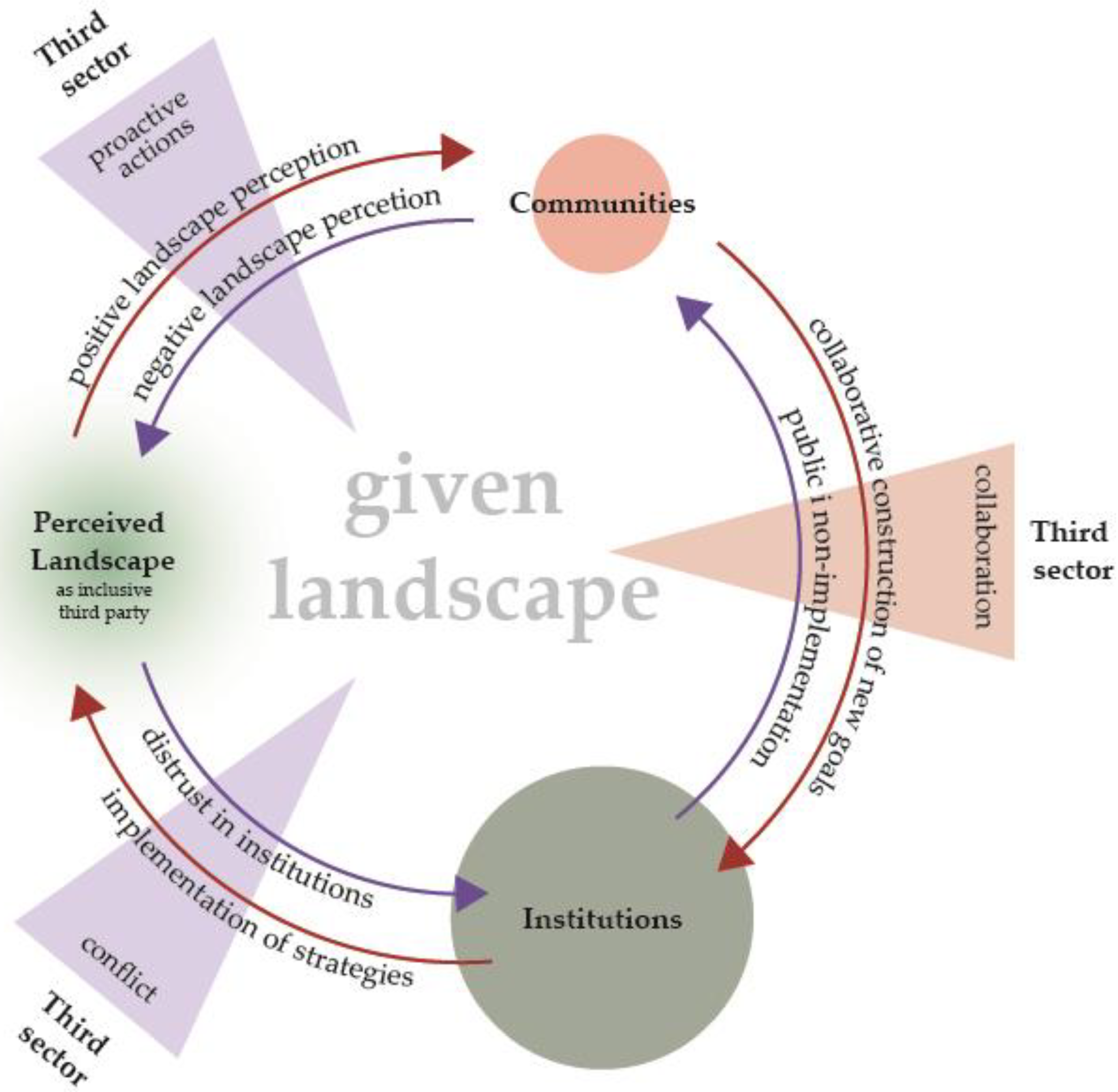
From a Social Perspective
As mentioned in the previous section, the city south of the Oreto is characterized by a disadvantaged social and economic context compared to the more central parts of Palermo, determined, not least, by a lack of public services. This determines the presence in the city of Palermo of social movements for the right to housing, but there is not a high number (lately growing slightly) of movements linked to socio-environmental aspects. An important role is currently played by the actor “Ecomuseo del Mare Memoria Viva”, located inside the former locomotive depot of S.Erasmo (on the coast). The activities of strong social and cultural nature that it promotes (including events, demonstrations, walks, workshops for adults and children) have helped to create a network of different actors, like associations, small companies and individual citizens, that collaborate with the eco-museum itself, generating an increase in collective awareness regarding the conditions of the river and of the riverbed condition, recalling a sense of collective responsibility towards what could be a common good. Movements, such as “Salviamo l’Oreto” are thus detected, a committee born from the idea of acting for the revaluation and protection of the river and which acts by disseminating information and connecting all interested parties. Another actor is the “Comitato promotore per il contratto di fiume e di costa Oreto” (promoter committee for the Oreto River and coast contract), which brings together actors not only from the city of Palermo but also from the municipalities of Monreale and Altofonte, which are crossed by the river. Finally, the working group named “Comunità Agroecologica e Servizio dell’Agricoltura” (C.A.S.A., Agroecological Community and Agriculture Service) is a remarkable reality, of economic nature, aimed at creating a short, local and organic food network among the producers of the Oreto River valley (in fact, the river crosses a valley with a strong agricultural vocation), with the intention of protecting and promoting the rich biodiversity that still maintains the territory.
However, these remarkable energy movements are grafted onto an area characterized by a very high degree of inertia, in a way dictated also by the slowness in the construction of public works, including the already planned Oreto Park, waiting to be built for almost 20 years. The non-implementation of the plan has generated widespread political and territorial disaffection, in what can be recognized not solely as a systematic production of waste, but as the (re)production of socio-ecological waste relations [
35], determining the great friction between, on the one hand, the formal recognition of quality of the Oreto River as a natural ecological corridor, potential urban green infrastructure and connection with the territories of the metropolitan city, and on the other hand, a landscape perceived as waste, open-air landfill, sewer, somehow not worthy of care. This disaffection with the territory and consequently with the effectiveness of political action, determined by the vicious circle of marginality in which this part of the city has been immersed since its recent construction, determines a collective perception of the landscape characterized by a prevailing discomfort and environmental degradation, reflecting on the (self) narration of one’s own places (
Figure 7). Despite the permanent presence of the eco-museum, the ever-increasing presence of the third sector which very slowly intercepts a part of the community, it seems that the non-implementation of the Oreto Park project is determined by the perception of the landscape by single individuals and of the community, too, encouraging the permanence in a condition of discomfort in which it is not possible to activate virtuous processes starting from the recovery of the landscape system.
4. Conclusions
The ELC highlights the need to “establish and implement landscape policies aimed at the protection, management and planning of landscapes” (art. 5.b), as well as that of “initiating the procedure for the participation of the public, local and regional authorities and of the other subjects involved in the definition and implementation of landscape policies” (art. 5.c), to “integrate the landscape into territorial planning, urban planning policies and those of a cultural, environmental, agricultural, social and economic nature” (art. 5.d), and finally to “evaluate the identified landscapes, taking into account the specific values that are attributed to them by the subjects and populations concerned” (art. 6.c). The clear position expressed by the ELC on the fundamental role of the population appears above all significant if we consider the awareness that, in order to be able to effectively influence the policies and instruments that produce the most significant effects on the territory, it is necessary to directly involve the local populations and communities at the same time they generate those impacts and suffer their negative effects [
36,
37,
38,
39]. The case study of Palermo shows all its complexity that derives from the application of the principles of the ECL, implemented in Italy by the Code of Cultural Heritage and Landscape (Legislative Decree 42/2004) [
40].
From reading the case study, several critical points emerge. First of all, the need to overcome the sectoral disciplinary boundaries that have led to considering landscape assets as isolated elements [
41], subjected to separate readings and disciplines that do not return the complexity of the territory understood as stratification, is particularly significant of history and “signs”. This condition evidently relates to the principles of “institutional consultation” and “co-planning” constantly enunciated by the ELC but never effectively implemented. The urban history of Palermo, reinterpreted through the ups and downs that have developed around the Oreto River, has all the limits of an approach that struggles to integrate landscape and land use planning. However, despite the rigidity of the application of the restriction, the landscape legislation has safeguarded large sections of the river bed. On the other hand, the various PRGs of the city of Palermo have interpreted the agricultural landscape of the Oreto valley fundamentally as a “neutral” territory on which to build in the indifference of the identity and landscape values of the area. This process, which has modified the texture of the agricultural fabric, generating phenomena of fragmentation and altering the traditional organization of the territory, has not been matched by the formation of a “place awareness” [
42] by the communities residing in the area, or more generally in the city of Palermo. This statement sheds light on another ambiguous and controversial aspect of the ELC. The definition of landscape “as perceived by people”, with reference to the Oreto case study, opens up a series of questions relating to which community and what identity vision has generated the degradation in this part of the city. Historically, the degraded urban landscape of Oreto is the “spatial precipitate” of a hegemonic vision of dominant groups, political and economic, which in the intertwining of politics and forms of a driven neoliberalism, have erased the local identity and increased the distance—even before physical, social—between politics and citizens [
43]. As argued by Certomà [
44] (2011, 192):
A monolithic image of local communities does not recognize the ways in which unequal and exclusionary relations are inscribed into small-scale communities. Spatial organization, as a result of the living activities, reflects social orders and power structures; territoriality is a primary geographical expression of social power, which determines those who belong and those who don’t. Low-income groups and ethnic minorities are exposed to the power of dominant groups in the determination of their landscape because they generally have weaker political voice, they have less economic power and fewer opportunities to counteract this state of things. Instead of being idyllic, for a part of inhabitants their place shape can be oppressive and silencing.
And this is precisely what the Oreto landscape testifies to us. The plurality of subjects that make up the invisible and voiceless community of neighborhood residents experience the river as a spatial transfiguration of the segregation mechanisms and of the condition of material and relational deprivation in which they live and from which it is possible to escape only by moving away from the physical places of exclusion. The river is perceived by the resident community as a “waste” like their existential condition. For these reasons, before claiming the right to the landscape, with the establishment of the Oreto Park, they claim their broader right to the city. Can there be landscapes in which social deprivation, lack of services and public spaces, as well as precarious hygienic and health service conditions and lack of primary infrastructure fuel the resident community’s sense of exclusion and marginalization?
Compared to the Palermo experience, the situation does not appear yet mature. However, the recent bottom-up experiences that have developed around the river are responding with bottom-up adaptive processes or through social constructs of collective consciousness. Positive energies, which involve the inhabitants to claim their presence in the urban public sphere, and with it their right to the landscape as the primary expression of a broader “right to the city” [
45]. Significant, but numerically limited, signs of discontinuity that can contribute to modifying, conceptually and operationally, the models of actions, allowing for a full and substantial application of the principles of the Convention.


