
Multi-Hazard Risk Assessment and Landslide Susceptibility Mapping: A Case Study from Bensekrane in Algeria

 ,
,  ,
, 
Abstract
:1. Introduction
2. Data and Methodology
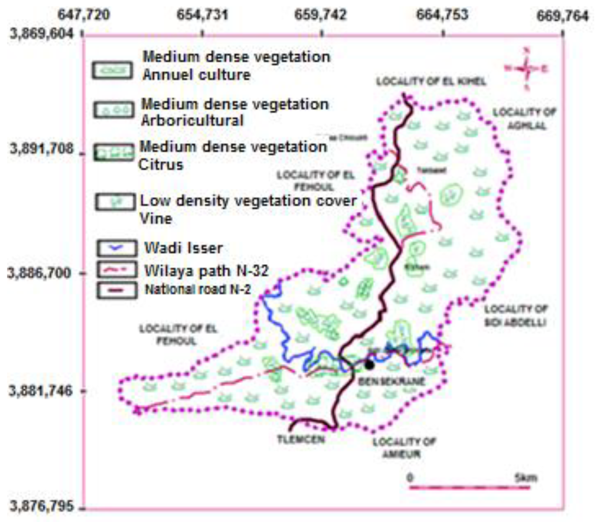
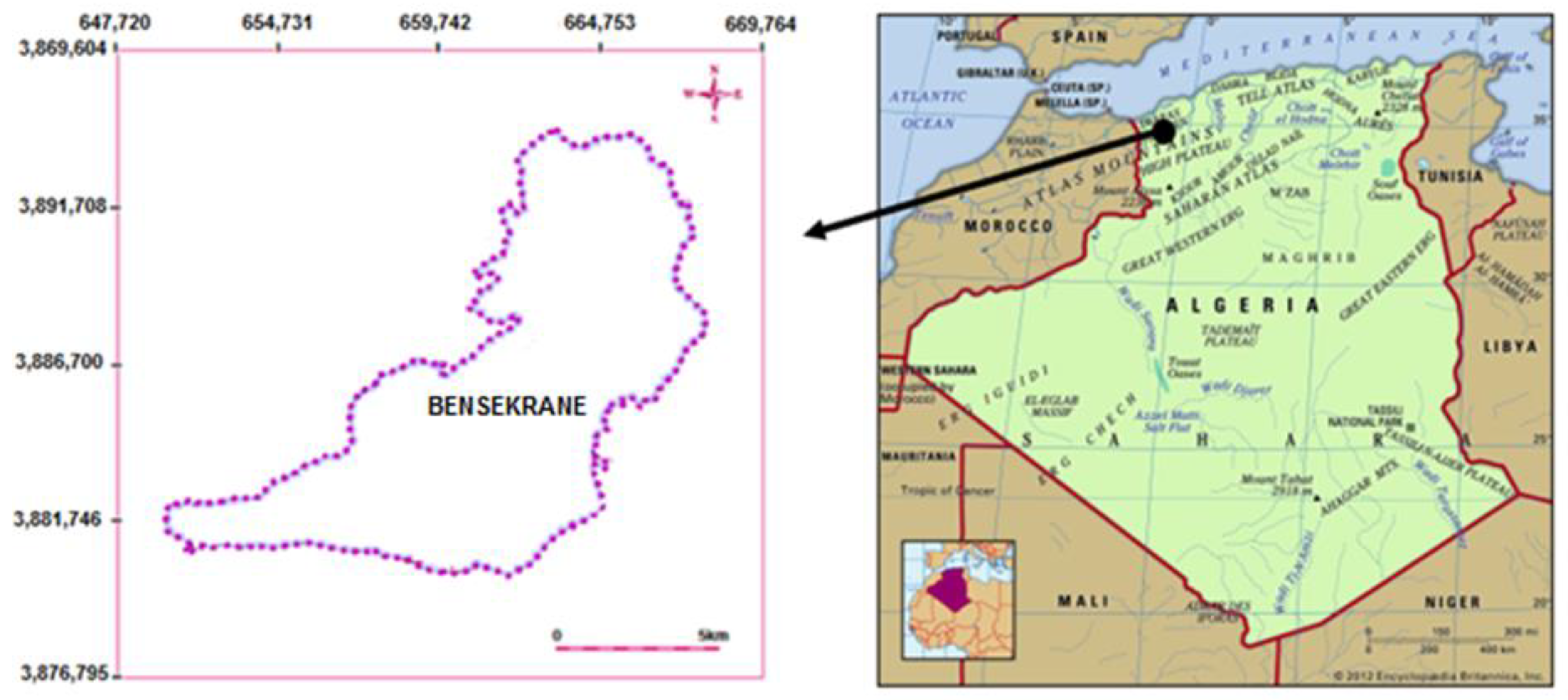
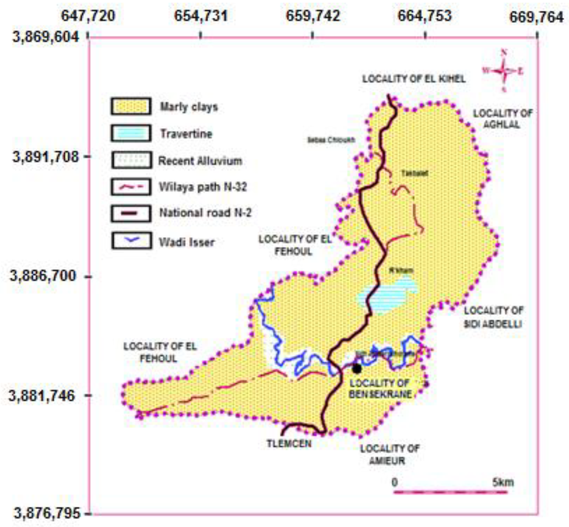
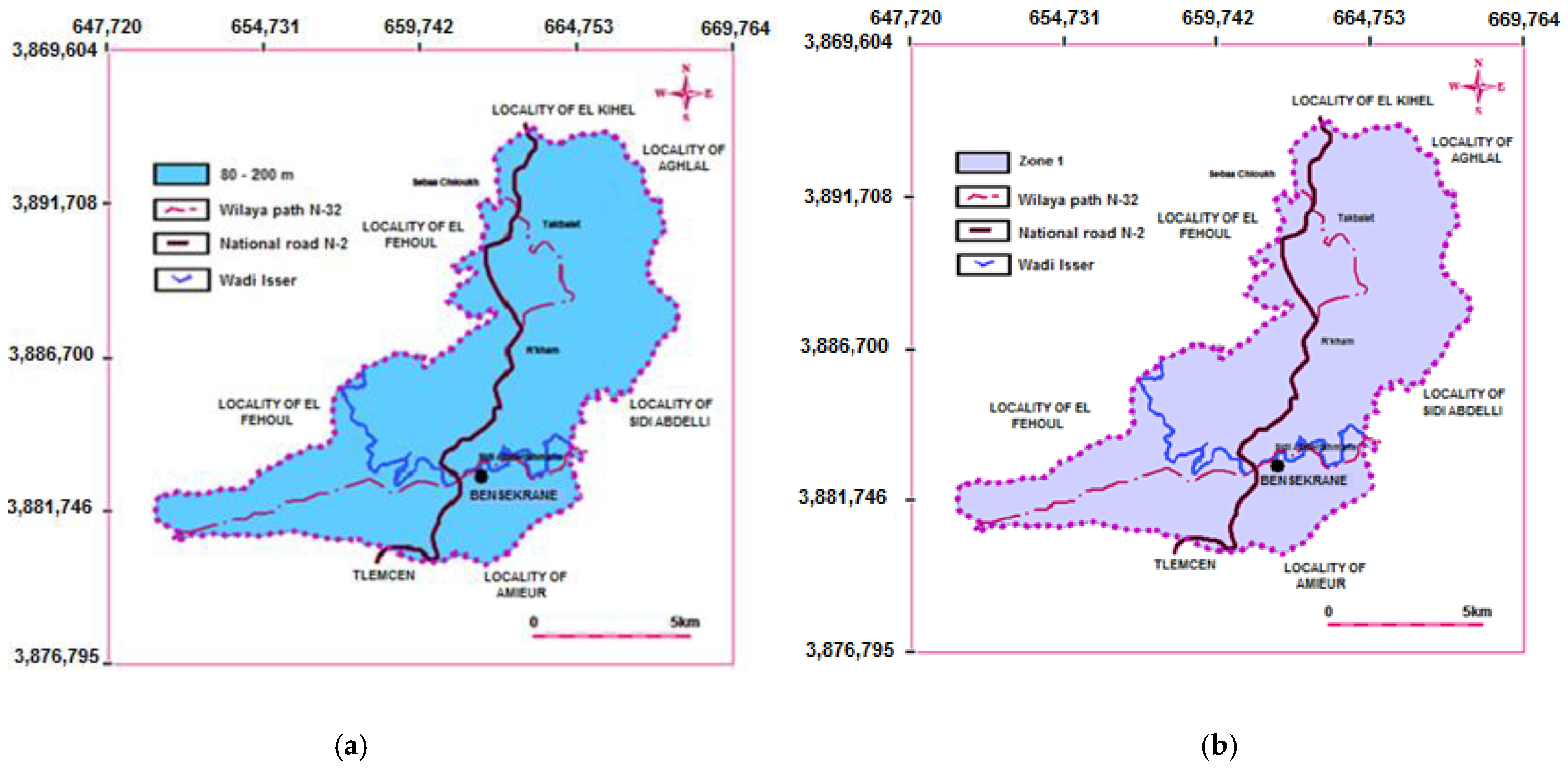
2.1. Description of Study Area
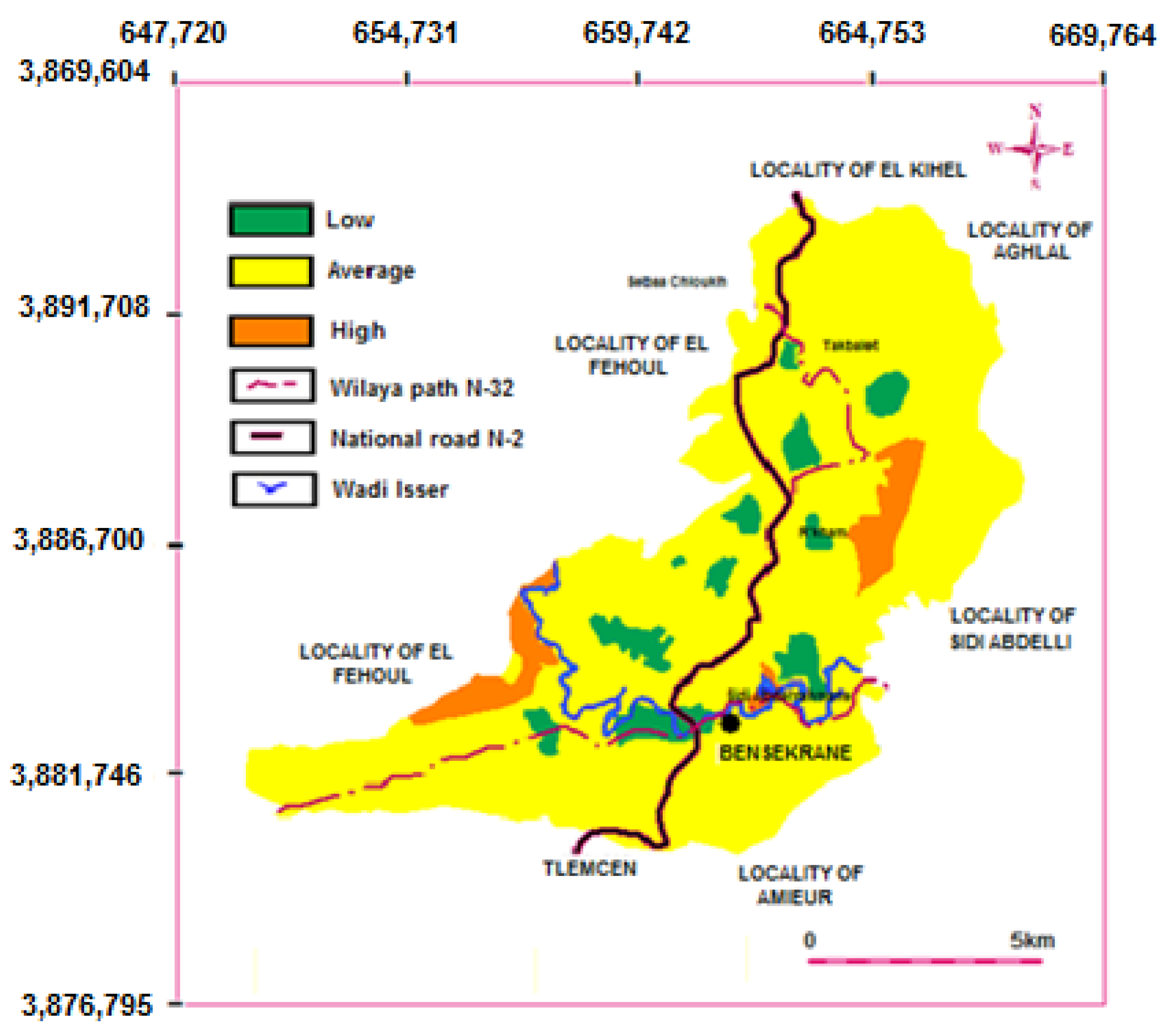
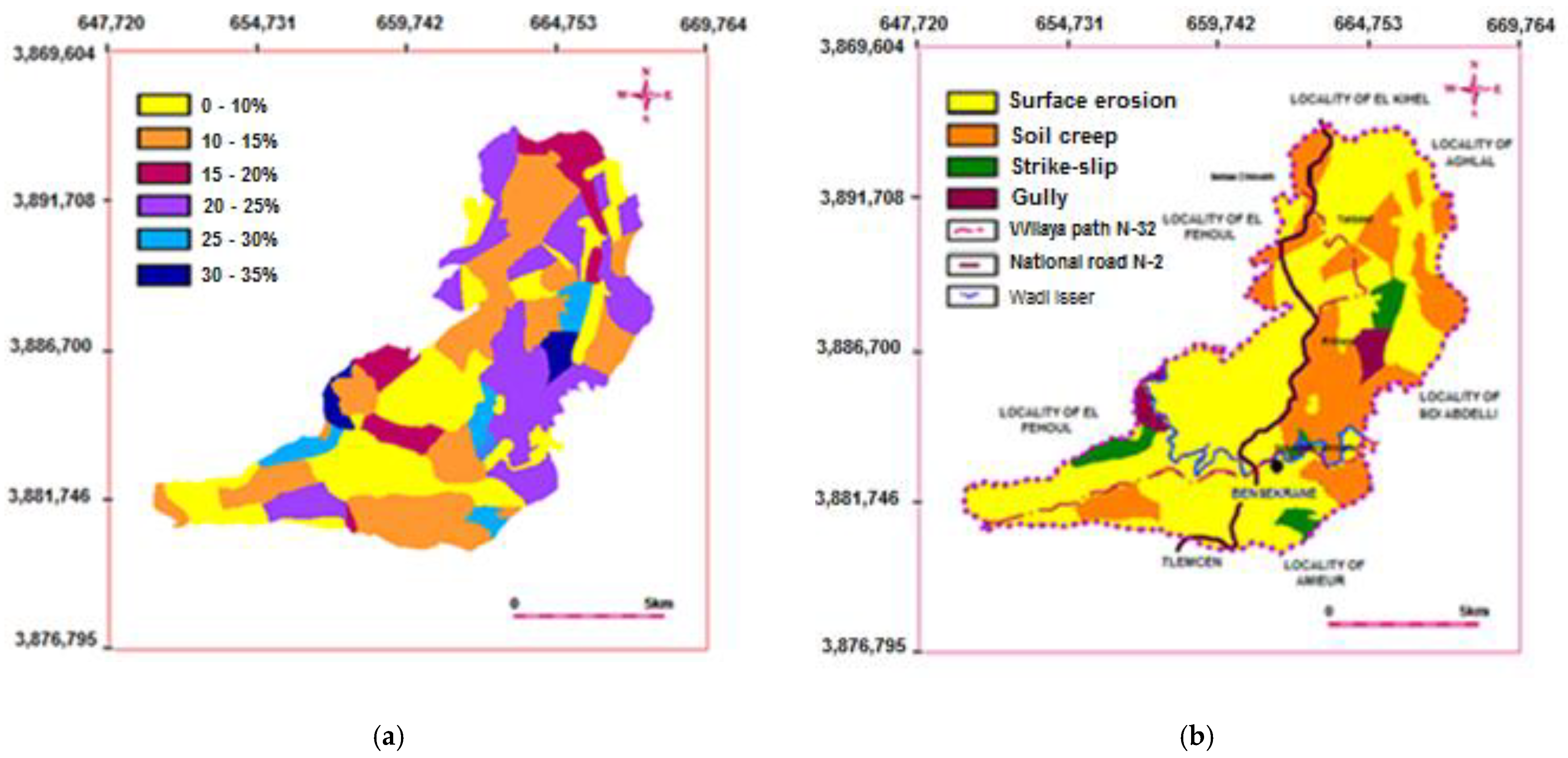
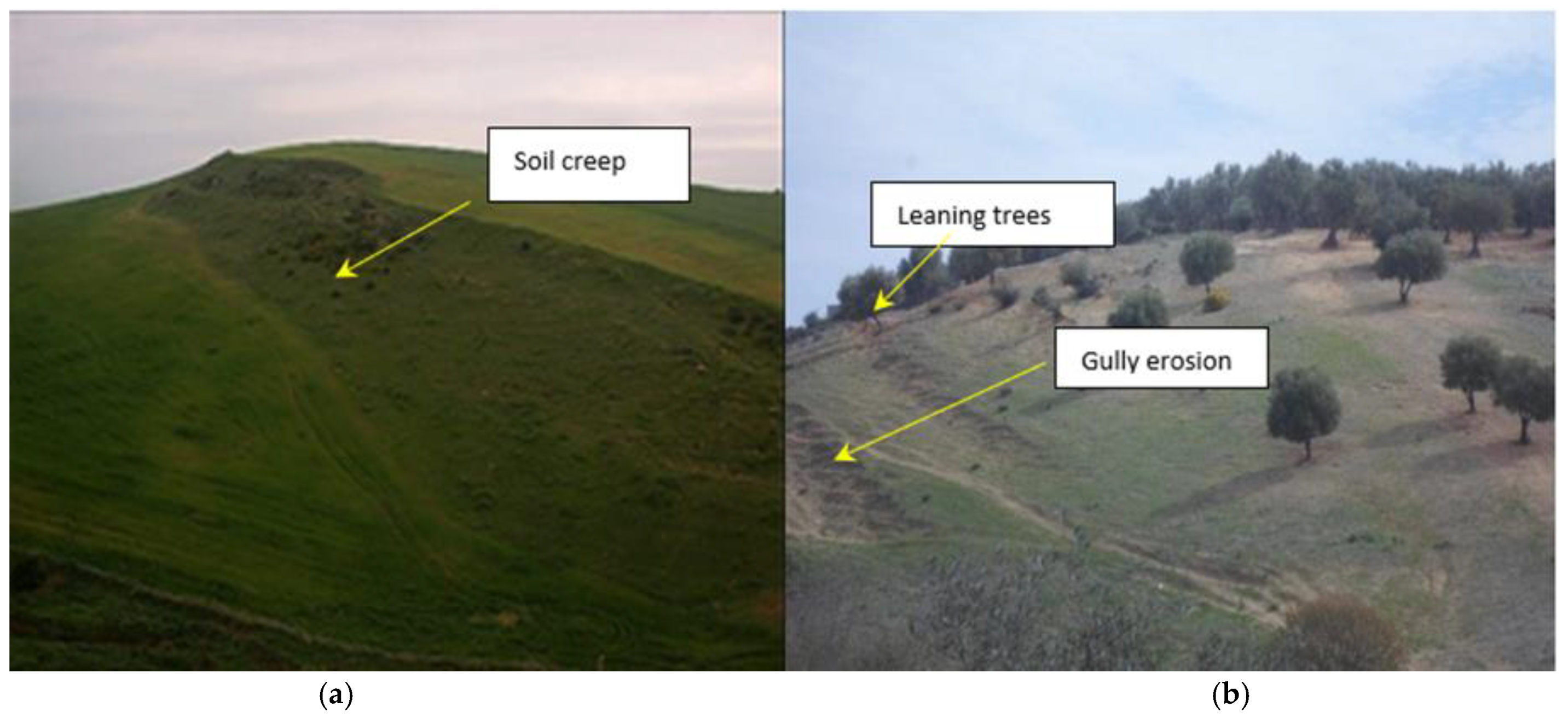
2.2. Influencing Factors
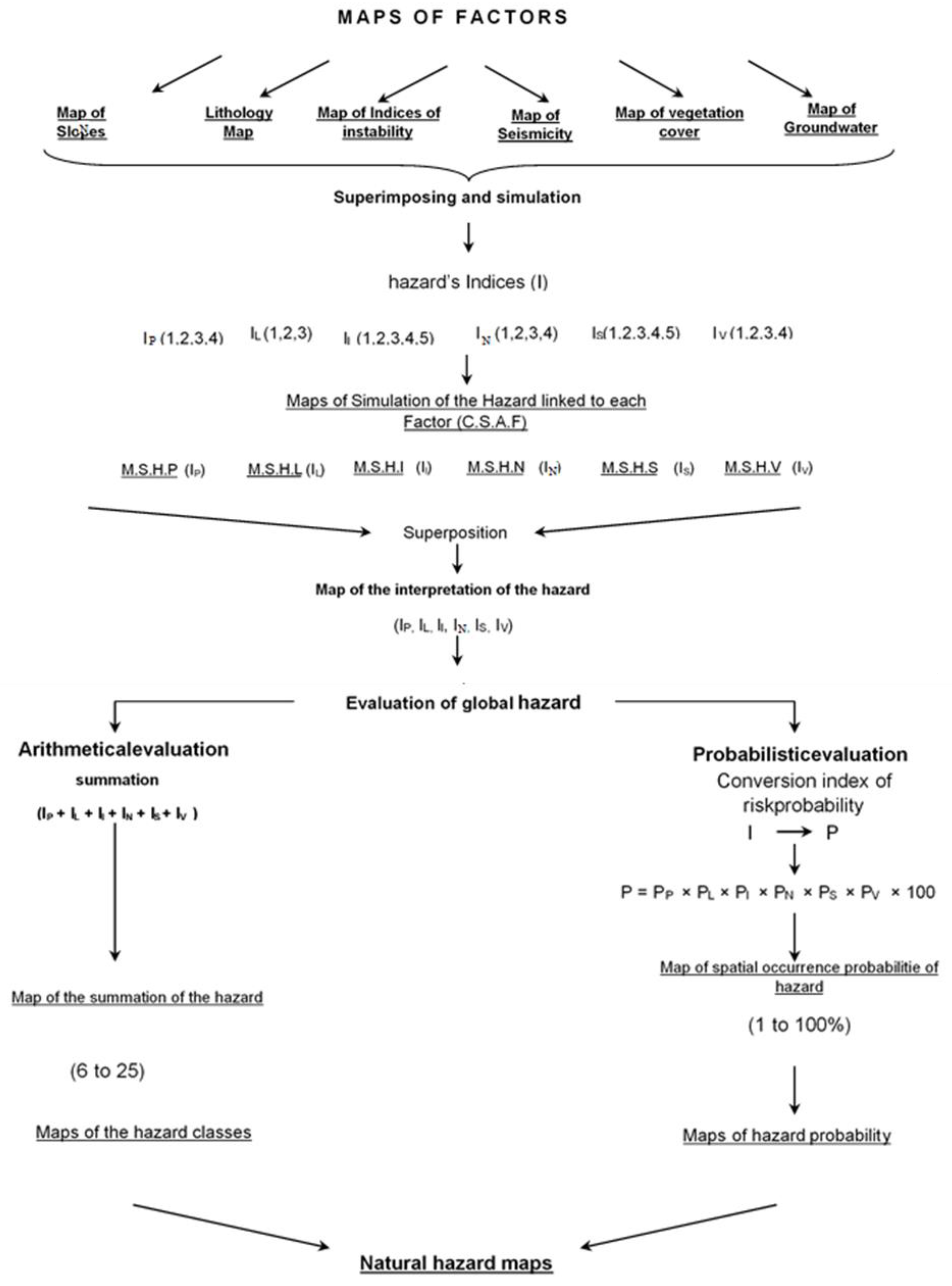
2.3. Methodology
2.3.1. Method of Farès
2.3.2. Modified Farès Method
2.4. Input Data
2.4.1. Permanents Factors
2.4.2. Dynamics Factors
2.4.3. Development of Multi-Hazard Risk Assessment Map
3. Results and Discussion
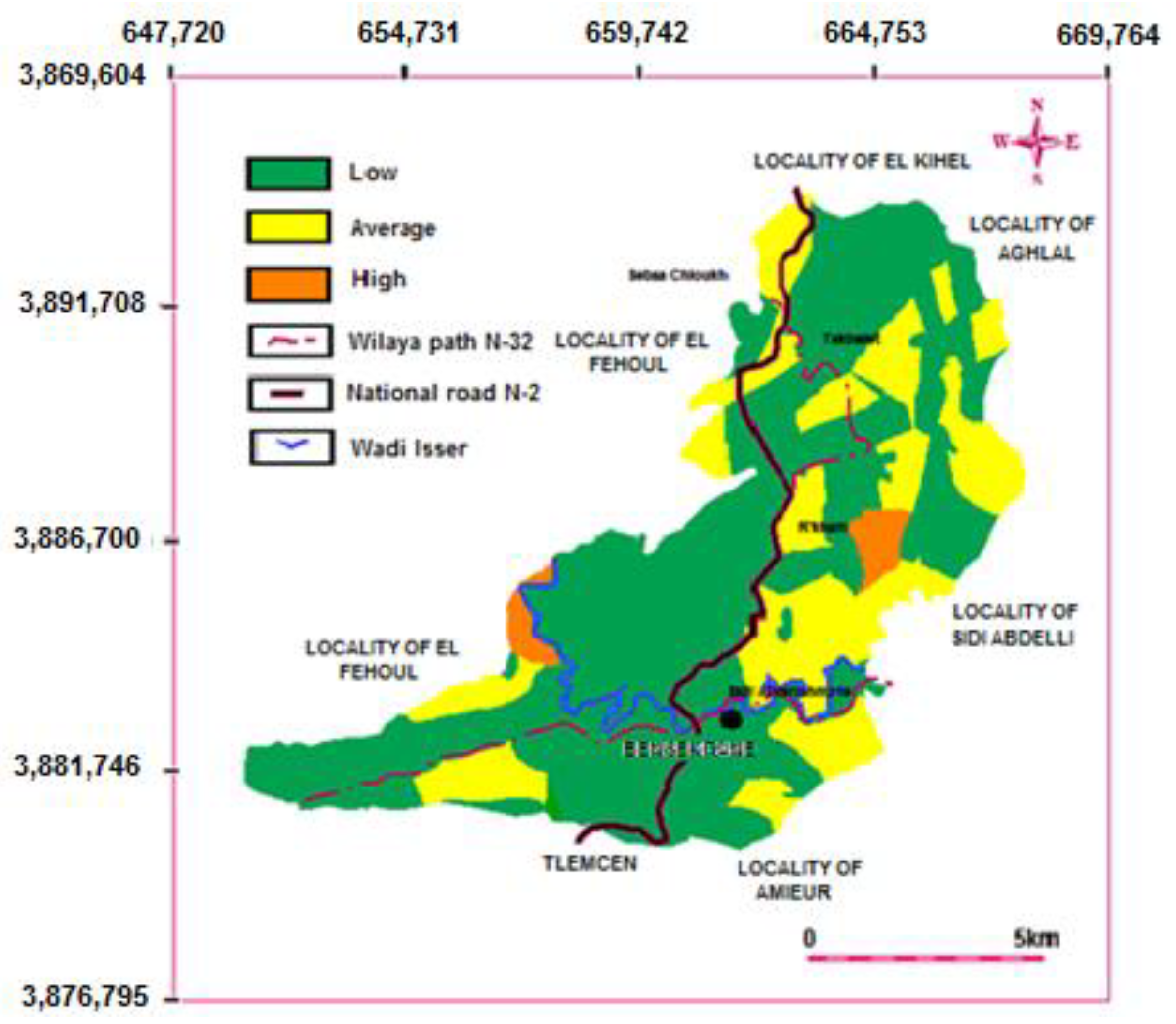
3.1. Hazard Assessment by Method of Farès
- −
- Class 1 (3–5): low hazard (520.62 Km2);
- −
- Class 2 (6–8): average hazard (214.68 Km2);
- −
- Class 3 (9–10): high hazard (17.7 Km2);
- −
- Class 4 (11–12): very high hazard.
- −
- Level 1 (1–10%): low hazard (547.62 Km2);
- −
- Level 2 (10–30%): average hazard (232.38 Km2);
- −
- Level 3 (30–50%): high hazard;
- −
- Level 4 (50–100%): very high hazard.
3.2. Hazard Assessment by Modified Farès Method
- −
- Class 1 (6–10): low hazard (43.65 Km2);
- −
- Class 2 (11–15): average hazard (687.48 Km2);
- −
- Class 3 (16–20): high hazard (48.87 Km2);
- −
- Class 4 (21–25): very high hazard.
- −
- Level 1 (0–0.5%): low hazard (547.62 Km2);
- −
- Level 2 (0.5–1.25%): average hazard (178.63 Km2);
- −
- Level 3 (1.25–4%): high hazard (53.75 Km2);
- −
- Level 4 (>4%): very high hazard.
4. Conclusions
Author Contributions
Funding
Institutional Review Board Statement
Informed Consent Statement
Data Availability Statement
Conflicts of Interest
References
- Pourghasemi, H.R.; Sadhasivam, N.; Amiri, M.; Eskandari, S.; Santosh, M. Landslide susceptibility assessment and mapping using state-of-the art machine learning techniques. Nat. Hazards 2021, 108, 1291–1316. [Google Scholar] [CrossRef]
- Ostad-Ali-Askari, K. Management of risks substances and sustainable development. Appl. Water Sci. 2022, 12, 65. [Google Scholar] [CrossRef]
- Pal, S.C.; Chakrabortty, R.; Saha, A.; Bozchaloei, S.K.; Pham, Q.B.; Linh, N.T.T.; Anh, D.T.; Janizadeh, S.; Ahmadi, K. Evaluation of debris flow and landslide hazards using ensemble framework of Bayesian-and tree-based models. Bull. Eng. Geol. Environ. 2022, 81, 1–25. [Google Scholar] [CrossRef]
- Wei, L.; Hu, K.; Hu, X.; Wu, C.; Zhang, X. Quantitative multi-hazard risk assessment to buildings in the Jiuzhaigou valley, a world natural heritage site in Western China. Geomat. Nat. Hazards Risk 2022, 13, 193–221. [Google Scholar] [CrossRef]
- UNISDR. Sendai Framework for Disaster Risk Reduction 2015–2030; United Nations Office for Disaster Risk Reduction (UNISDR): Geneva, Switzerland, 2015. [Google Scholar]
- Carrington, M.A.; Ranse, J.; Hammad, K. The impact of disasters on emergency department resources: Review against the Sendai framework for disaster risk reduction 2015–2030. Australas. Emerg. Care 2021, 24, 55–60. [Google Scholar]
- Labriki, A.; Chakiri, S.; Nouaim, W.; Allouza, M.; Ezzayani, J. Approche méthodologique d’évaluation de susceptibilité des versants aux glissements de terrain par un modèle volumique de l’aléa; Application au secteur de Boujibar Al Hoceima (Rif, Maroc). Eur. Sci. J. ESJ 2016, 12, 206. [Google Scholar] [CrossRef]
- Byou, T.; Obda, K.; Taous, A.; Obda, I. Susceptibilité aux glissements de terrain dans la ville d’Al Hoceima et sa périphérie: Application de la méthode de la théorie de l’évidence. Geomatica 2021, 75, 1–27. [Google Scholar] [CrossRef]
- Martin, P. Ces Risques que L’on dit Naturels; Editions Eyrolles: Paris, France, 2007; ISBN13: 978-2-212-11917-6. [Google Scholar]
- Bonnard, C. Landslides. In Proceedings of the Fifth International Symposium on Landslides, Lausanne, Switzerland, 10–15 July 1988. [Google Scholar]
- Favre, J.L. Géotechnique, Sécurité des Travaux, Risque, Modélisation Incertaine, Fiabilité, Analyse de Risque; Ellipses: Washington, DC, USA, 2004. [Google Scholar]
- Favre, J.L. Trois Régions du Danger sur les Mouvements de Terrain. In Proceedings of the Actes du Colloque International: Risques, Vulnérabilité et Fiabilité dans la Construction, Alger, Algérie, 12–13 October 2003. [Google Scholar]
- Toutain, C. Prévenir les Catastrophes Naturelles? Les Essentiels Milan: Toulouse, France, 2001. [Google Scholar]
- Flageollet, J.C. Les Mouvements de la Terre et Leur Prévention; Edition Masson: Paris, France, 1989. [Google Scholar]
- Benzenine, F.; Allal, M.A.; Abdelbaki, C. Systémique et SIG: Prévention Contre L’Aléa des Mouvements de Pente, cas de la Commune de Bensekrane, Tlemcen (Algérie); Editions Universitaires Européenne: Saarbrücken, Germany, 2012. [Google Scholar]
- Besson, L. Natural Hazards in the Mountains, Treatment, Surveillance; Artès-Publialp: Grenoble, France, 1996; 438p. [Google Scholar]
- Besson, L.; Grask, E.; Toulemont, E. Plans de Prévention des Risques Naturels, Risques des Mouvements de Sol, Guide Méthodologique; La Documentation Française: Paris, France, 1999. [Google Scholar]
- Corominas, J.; Mavrouli, C. Estimation quantitative du risque (QRA) pour les bâtiments liés aux éboulements rocheux: Progrès et défis. Mémoire Société Vaud. Sci. Nat. 2013, 25, 229–242. [Google Scholar]
- Augendre, M. La Cartographie et le Zonage. La Vulnérabilité, un Concept Fondamental au Cœur des Méthodes D’Evaluation des Risques Naturels; Collection Géorisques: Montpellier, France, 2005; pp. 9–26. [Google Scholar]
- Clerici, A.; Perego, S.; Tellini, C.; Vescovi, P. A procedure for landslide susceptibility zonation by the conditional analysis method. Geomorphology 2002, 48, 349–364. [Google Scholar]
- Ostad-Ali-Askari, K. Investigation of meteorological variables on runoff archetypal using SWAT: Basic concepts and fundamentals. Appl. Water Sci. 2022, 12, 177. [Google Scholar] [CrossRef]
- Wilde, M.; Günther, A.; Reichenbach, P.; Malet, J.-P.; Hervas, J. Pan-European landslide susceptibility mapping: ELSUS Version 2. J. Maps 2018, 14, 97–104. [Google Scholar]
- Guzzetti, F.; Mondini, A.C.; Cardinali, M.; Fiorucci, F.; Santangelo, M.; Chang, K.-T. Landslide inventory maps: New tools for an old problem. Earth Sci. Rev. 2012, 112, 42–66. [Google Scholar] [CrossRef]
- Bathrellos, G.D.; Skilodimou, H.D.; Chousianitis, K.; Youssef, A.M.; Pradhan, B. Suitability estimation for urban development using multi-hazard assessment map. Sci. Total Environ. 2017, 575, 119–134. [Google Scholar] [CrossRef]
- Bell, R.; Glade, T. Multi-hazard analysis in natural risk assessments. WIT Trans. Ecol. Environ. 2004, 77, 1–10. [Google Scholar]
- Çellek, S. Effect of the Slope Angle and Its Classification on Landslide. Nat. Hazards Earth Syst. Sci. Discuss. 2020, 87, 1–28. [Google Scholar] [CrossRef]
- Guzzetti, F.; Reichenbach, P.; Cardinali, M.; Galli, M.; Ardizzone, F. Probablistic Landslide Hazard Assessment at the Basin Scale. Geomorphology 2005, 72, 272–299. [Google Scholar]
- Kumar, N.; Yamaç, S.S.; Velmurugan, A. Applications of remote sensing and GIS in natural resource management. J. Sci. Assoc. 2015, 20, 1–6. [Google Scholar]
- Abdelbaki, C.; Touaibia, B.; Ammari, A.; Mahmoudi, H.; Goosen, M. Contribution of GIS and Hydraulic Modeling to the Management of Water Distribution Network. In Geospatial Challenges in the 21st Century; Springer: Cham, Switzerland, 2019. [Google Scholar] [CrossRef]
- Koutsopoulos, K.; de Miguel González, R.; Donert, K. (Eds.) Geospatial Challenges in the 21st Century; Key Challenges in Geography; Springer: Cham, Switzerland, 2019. [Google Scholar] [CrossRef]
- Wang, Y.; Fang, Z.; Wang, M.; Peng, L.; Hong, H. Comparative study of landslide susceptibility mapping with different recurrent neural networks. Comput. Geosci. 2020, 138, 104445. [Google Scholar] [CrossRef]
- Gill, J.C.; Malamud, B.D. Anthropogenic processes, natural hazards, and interactions in a multihazard framework. Earth Sci. Rev. 2017, 166, 246–269. [Google Scholar] [CrossRef]
- Gill, J.C.; Malamud, B.D. Reviewing and visualizing the interactions of natural hazards. Rev. Geophys. 2014, 52, 680–722. [Google Scholar] [CrossRef]
- LCPC. Collection Environnement, Caractérisation et Cartographie de L’Aléa dû Aux Mouvements de Sol; Les Risques Naturels: Paris, France, 2000. [Google Scholar]
- Anbalagan, R. Landslide hazard evaluation and zonation mapping in mountainous terrain. Eng. Geol. 1992, 32, 269–277. [Google Scholar] [CrossRef]
- Grossi, P.; Kunrenther, H. Catastrophe Modeling: A New Approach to Managing Risk; Springer: Berlin/Heidelberg, Germany, 2005. [Google Scholar] [CrossRef]
- Farès, A.; Rollet, M.; Broquet, P. Méthodologique de la cartographie des risques naturels liés aux mouvements de terrain (Région Taounate, Rif Maroc). Rev. Française Géotech. 1994, 69, 63–72. [Google Scholar] [CrossRef]
- Gilles, A.; Cartographie du Risque Naturel Dans le Monde. Etude Comparative Entre une Approche D’Ordre Social et une Approche D’Ordre Economique de la Vulnérabilité. Cybergeo: Eur. J. Geogr. 2004. Available online: http://journals.openedition.org/cybergeo/2614 (accessed on 3 February 2022).
- Allal, M.A. Technical Report, Dossier Géotechnique Commune de Bensekrane; URBA: Tlemcen, Algérie, 2004. [Google Scholar]
- Zhou, S.; Chen, G.; Fang, L.; Nie, Y. GIS-Based Integration of Subjective and Objective Weighting Methods for Regional Landslides Susceptibility Mapping. Sustainability 2016, 8, 334. [Google Scholar] [CrossRef]
- Nachappa, G.T.; Ghorbanzadeh, O.; Gholamnia, K.; Blaschke, T. Multi-Hazard Exposure Mapping Using Machine Learning for the State of Salzburg, Austria. Remote Sens. 2020, 12, 2757. [Google Scholar]
- Youssef, A.M.; Mahdi, A.M.; Al-Katheri, M.M.; Pouyan, S.; Pourghasemi, H.R. Multi-hazards modeling using machine learning algorithms in Southwestern Saudi Arabia. Res. Sq. 2022, in press. [Google Scholar] [CrossRef]
- Karray, M.; Ghobrial, F. Analyse Dynamique des Pentes Argileuses et des Remblais Construits sur des Dépôts D’Argile; Rapport Final Geo-03-13; Université de Sherbrooke: Sherbrooke, QC, Canada, 2013. [Google Scholar] [CrossRef]


| References | Triggering Factors |
|---|---|
| Laboratoire Central des Ponts et Chaussées (LCPC) [34] | Gravity |
| Water | |
| Morphology | |
| Vegetation | |
| Climate | |
| Earthquakes | |
| Volcanism | |
| Anbalagan [35] | The lithology |
| The discontinuities | |
| The slope | |
| The relief | |
| The hydrogeology | |
| The vegetation | |
| Farès [36,37] | The lithology |
| Instability indices | |
| The slope |
| IP | 1 | 2 | 3 | 4 | - |
| PP | 0.25 | 0.5 | 0.75 | 1 | |
| IL | 1 | 2 | 3 | 4 | 5 |
| PL | 0.2 | 0.4 | 0.6 | 0.8 | 1 |
| II | 1 | 2 | 3 | 4 | 5 |
| PI | 0.2 | 0.4 | 0.6 | 0.8 | 1 |
| Method | Considered Factors | Risk Indices | Partial Probability |
|---|---|---|---|
| Farès, 1994 | Lithology | IL | PL |
| Instability indices | II | PI | |
| Slope | IP | PP |
| IP | 1 | 2 | 3 | 4 | - |
| PP | 0.25 | 0.5 | 0.75 | 1 | |
| IL | 1 | 2 | 3 | 4 | 5 |
| PL | 0.2 | 0.4 | 0.6 | 0.8 | 1 |
| II | 1 | 2 | 3 | 4 | 5 |
| PI | 0.2 | 0.4 | 0.6 | 0.8 | 1 |
| IS | 1 | 2 | 3 | 4 | 5 |
| PS | 0.2 | 0.4 | 0.6 | 0.8 | 1 |
| IV | 1 | 2 | 3 | 4 | - |
| PV | 0.25 | 0.5 | 0.75 | 1 | |
| IN | 1 | 2 | 3 | 4 | - |
| PN | 0.25 | 0.5 | 0.75 | 1 |
| Method | Considered Factors | Risk Indices | Partial Probability | |
|---|---|---|---|---|
| Modified Farès | Permanent | Slope | IP | PP |
| Lithology | IL | PL | ||
| Instability indices | II | PI | ||
| Dynamic | Seismicity | IS | PS | |
| Vegetation cover | IV | PV | ||
| Groundwater | IN | PN | ||
| Factors | Indices of Each Factor |
|---|---|
| Slope | IP = 1 for a slope of 0–30% IP = 2 for a slope of 30–35% |
| Lithology | IL = 3 for marly clay IL = 1 for travertine |
| Instability indices | II = 5 for gullying II = 4 for strike-stripe faults II = 3 for creep soil II = 1 for surface erosion |
| Seismicity | IS = 2 for Zone 1 |
| Vegetation cover | IV = 2 for moderately dense vegetation cover, moderate vegetation surface IV = 3 for low vegetation cover, some plantations |
| Groundwater | IN = 1 for a depth of 75–100 m |
| Factors | Indices of Each Factor |
|---|---|
| Slope | PP = 0.25 for a slope of 0–10% PP = 0.5 for a slope of 30–35% |
| Lithology | PL = 0.6 for marly clay PL = 0.2 for travertine |
| Instability indices | PI = 1 for gullying PI = 0.8 for strike-stripe-faults PI = 0.6 for creep soil PI = 0.2 for surface erosion |
| Seismicity | PS = 0.4 for Zone 1 |
| Vegetation cover | PV = 0.5 for moderately dense vegetation cover, moderate vegetation surface PV = 0.75 for low vegetation cover, some plantations |
| Groundwater | PN = 1 for a depth of 75–100 m |
Disclaimer/Publisher’s Note: The statements, opinions and data contained in all publications are solely those of the individual author(s) and contributor(s) and not of MDPI and/or the editor(s). MDPI and/or the editor(s) disclaim responsibility for any injury to people or property resulting from any ideas, methods, instructions or products referred to in the content. |
© 2023 by the authors. Licensee MDPI, Basel, Switzerland. This article is an open access article distributed under the terms and conditions of the Creative Commons Attribution (CC BY) license (https://creativecommons.org/licenses/by/4.0/).
Share and Cite
Benzenine, F.; Allal, M.A.; Abdelbaki, C.; Kumar, N.; Goosen, M.; Gathenya, J.M. Multi-Hazard Risk Assessment and Landslide Susceptibility Mapping: A Case Study from Bensekrane in Algeria. Sustainability 2023, 15, 2812. https://doi.org/10.3390/su15032812
Benzenine F, Allal MA, Abdelbaki C, Kumar N, Goosen M, Gathenya JM. Multi-Hazard Risk Assessment and Landslide Susceptibility Mapping: A Case Study from Bensekrane in Algeria. Sustainability. 2023; 15(3):2812. https://doi.org/10.3390/su15032812
Chicago/Turabian StyleBenzenine, Faïla, Mohamed Amine Allal, Chérifa Abdelbaki, Navneet Kumar, Mattheus Goosen, and John Mwangi Gathenya. 2023. "Multi-Hazard Risk Assessment and Landslide Susceptibility Mapping: A Case Study from Bensekrane in Algeria" Sustainability 15, no. 3: 2812. https://doi.org/10.3390/su15032812
APA StyleBenzenine, F., Allal, M. A., Abdelbaki, C., Kumar, N., Goosen, M., & Gathenya, J. M. (2023). Multi-Hazard Risk Assessment and Landslide Susceptibility Mapping: A Case Study from Bensekrane in Algeria. Sustainability, 15(3), 2812. https://doi.org/10.3390/su15032812