Abstract
The past two decades have seen an intensive development in two-way coupled atmospheric and hydrological models, providing new opportunities to thoroughly understand hydrology–atmosphere coupling and improve hydrometeorological forecasting, which has not been possible before. This paper summarizes recent developments in hydrological presentation in land surface models (LSMs) and climate models, and the two-way coupling of atmospheric and hydrological models. The fully coupled models have been widely applied in identifying the impact of lateral surface and subsurface water transport in a land–atmosphere coupled system, and hydrometeorological simulations using techniques such as parameter calibration, data assimilation, and hydrology model structure revision have been used to improve the model accuracy. However, their applications still face major challenges, e.g., the complexity of hydrological parameter calibration, the lack of understanding of the physical mechanisms at high resolution, the parameterization of anthropogenic activities, and the limitations in simulation domain and period. Despite these difficulties, fully coupled atmospheric and hydrological models will gradually evolve into powerful tools to reproduce regional water cycles, offering significant potential for scientifically investigating water resources security issues affected by both climate change and human activities.
1. Introduction
The water cycle is a key component of the earth system on scales from global to regional [1], interconnecting the land, atmosphere, ocean and subsurface dynamics [2]. With the growth in populations and economic development over the past few decades, the influence of human activities on the water cycle has gradually emerged [3,4]. Meanwhile, extreme hydrological events such as floods and droughts occur more frequently, accompanying global climate change [5,6,7] and anthropogenic activities [8,9,10]. The topic of the interactions and feedbacks between regional climate change and hydrological processes has been one of the scientific issues in water-related sciences [11,12,13,14]. Hence, modeling atmospheric, land surface, and surface and subsurface hydrological processes is critical for thoroughly understanding the change of the terrestrial water cycle and assessing regional water resources’ security in the context of climate change and human activities, and maintaining sustainable water management under environmental and society–economic stress.
Coupled atmospheric and hydrological models are effective and powerful tools used to study the scientific issues of the complex systems involving the atmosphere, land surface, and continental hydrosphere. In the 1960s, simple land surface parameterization schemes (e.g., a leaky bucket parameterization [15]) were first incorporated into climate models, and progressively developed to include more sophisticated representations. The Project for Intercomparison of Land-surface Parameterization Schemes (PILPS), launched in the 1990s [16,17,18,19], demonstrated that three-generation land surface models (LSMs) such as the Biosphere–Atmosphere Transfer Scheme [20] and Community Land Model (CLM) [21] were able to be used for long-term climatic and hydrological process simulations. Hydrologists also participated in the development of LSMs by introducing the Variable Infiltration Capacity- (VIC) [22] and TOPMODEL- [23] based approaches to improve the capability of LSMs in modeling runoff production. However, incorporating these algorithms might result in a discordant climate modeling system [16,24]. Therefore, hydrology models were alternatively integrated into LSMs [25,26,27] to enhance the stability of climate modeling systems.
From the beginning of the 21st century, international projects including the World Climate Research Program (WCRP), International Geosphere Biosphere Program (IGBP), and Global Energy and Water Cycle Experiment (GEWEX) have emphasized coupling hydrology models and regional climate models as one important topic. Recently, two-way coupled atmospheric and hydrological models (e.g., PF.WRF [28], TerrSysMP [29], WRF-Hydro [30], WRF-HMS [31], AHMS [32], etc.) have been developed for comprehensively modeling regional water cycles. In this paper, we first summarize the development of hydrological representations in LSMs and climate models, including simple representations of surface runoff and groundwater (or aquifers), as well as two-way coupled atmospheric and hydrological models; we then demonstrate the major applications of two-way coupled atmospheric and hydrological models, and identify the main challenges and opportunities associated with fully coupled hydrometeorological simulations.
2. Representation of Hydrological Processes in LSMs and Climate Models
Climate models and hydrological models have been developed independently for decades due to their different focuses and purposes [33,34]. Climate models have been gradually developed to include the sophisticated representation of bio-geophysical, bio-geochemical, and hydrological processes in land surface schemes. Hydrology models have experienced continuous evolution from lumped to distributed, from statistically empirical to physically based, and from simple rainfall–runoff models to models with complex land surface processes (e.g., VIC [22], TOPMODEL [23]). In the past few decades, hydrological components such as groundwater/aquifer and surface runoff have gradually been incorporated to enhance hydrological representation in mesoscale climate models [35,36,37,38,39]. In recent years, the coupling of hydrology models into regional climate models has rapidly developed [25,28,29,30,31,40,41,42] and gained enormous popularity. The schematic diagrams of climate models, hydrological models, and coupled models are presented in Figure 1.
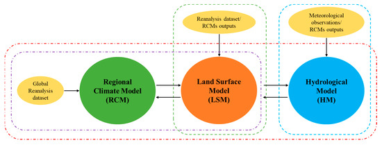
Figure 1.
Simplified schematic of different models, which includes the two-way coupled atmospheric and hydrological model (frame with red dot–dashed line), the regional climate model (frame with purple dot–dashed line), the offline land surface model (frame with green dashed line), and the hydrological model (frame with blue dashed line). The LSM is one of the surface physics schemes in RCMs, and it links the RCM and the HM as an interface in two-way coupled atmospheric and hydrological models.
2.1. Representation of Surface Runoff
Conventional LSMs use one-dimensional vertical treatment, assuming homogeneous soil properties and moisture conditions across horizontal areas spanning hundreds of kilometers [43]. Its poor runoff calculation results in an unrealistic latent heat flux [44], as the calculation of evapotranspiration is strongly associated with the runoff calculation. Given that hydrology models have considerable advantages in reproducing hydrological processes, researchers have attempted to incorporate some algorithms of hydrology models, such as runoff production and infiltration, into LSMs or climate models. Two approaches, such as the TOPMODEL-based approach and the VIC approach, are widely used for improving surface runoff estimates in LSMs.
The TOPMODEL-based approach [23] uses a topographic index to explicitly describe the subgrid variability of soil moisture, as surface heterogeneity strongly impacts the surface energy and water budgets [43]. For example, Famiglietti et al. [45] used the statistical distribution of the topographic–soil index (the catchment-scale TOPMODEL approach) to simulate catchment hydrological fluxes in a simple soil–vegetation–atmosphere transfer scheme (SVATS), developing a TOPMODEL-based atmosphere transfer scheme (TOPLATS). Similarly, Stieglitz et al. [46] incorporated the analytic form of TOPMODEL equations (a three-parameter gramma distribution function) into the soil column framework, which can be easily applied in LSMs to predict the saturation fraction of the watershed. Based on these, Niu et al. [37] proposed a simple TOPMODEL-based runoff parameterization (SIMTOP), in which an exponential function was used to describe the fractional saturated area based on groundwater table depth. SIMTOP has been validated at a watershed scale (the Sleepers River watershed in Vermont, USA) and on a global scale (using monthly runoff data of UNH-GRDC), demonstrating that SIMTOP performs better than the baseline runoff formulation in Community Land Model version 2.0 (CLM2.0). More recently, the SIMTOP approach was used to represent surface water infiltration and runoff in some popularly used LSMs, such as the Noah-Multiparameterization Land Surface Model [47], and CLM 2.0 and its subsequent updates [39].
The VIC approach is often used to represent surface runoff in LSMs, as it possesses the advantage of modeling control over the catchment characteristics of surface hydrological processes. The VIC approach [22], a variable infiltration capacity model approach, allows the generation of surface runoff before the land surface grid is entirely saturated. In the coupled macroscale ISBA (interaction between the soil, the biosphere and the atmosphere) and MODCOU (a hydrological model), the VIC model-based runoff formulation was used to build a sub-grid-scale parameterization of surface runoff [48]. The model, which was applied to the Hydrologic Atmospheric Pilot Experiment area [49], was shown to simulate daily streamflow properly in this region in comparison to the observations. Additionally, the ISBA model was applied to the Rhone River basin, with a drainage area of 86,496 km2, at a resolution of 8 km [50] for one year, which highlights the importance of topography and snow to the hydrological regime in the Rhone River basin. Currently, the VIC approach is included in Community Land Model version 4.5 (CLM 4.5) and its subsequent updates as an alternative optional runoff generation scheme [39].
2.2. Representation of Groundwater
In very earlier LSMs, the lower boundary of the soil hydrology model is simplified as a constant flux or a function of overlying moisture gradient without aquifer representation. Many studies have shown that soil moisture plays an important role in the global energy and water balances [44,51,52,53]. The interactions of groundwater, vadose zone, and land surface can modify the distribution of soil moisture, and hence affect water and energy budgets in the land–atmosphere coupling system [53,54]. The well-known groundwater–atmosphere feedbacks and the recognition of groundwater’s long-term memory of the atmosphere motivate the description of groundwater in LSMs and climate models.
In some LSMs, the groundwater table is simply represented using analytic forms, with the focus on the vertical transport processes of groundwater. For example, Seuffert et al. [35] coupled the TOPMODEL-based land surface–atmosphere transfer scheme into the mesoscale weather prediction model Lokal Modell (LM), where the TOPMODEL approach is used to determine the spatial variability of soil moisture and water table depth. The coupled system showed an improvement in predicting energy fluxes and rain amount in comparison to standard LM simulations and measurement. Yeh et al. [55] used a statistical dynamics method to represent the sub-grid variability of water table depth, and a two-parameter gamma distribution to describe the dynamic probability distribution of water table depth in a land surface scheme. The validation demonstrated that the simulated hydrological variables and fluxes agree well with the observations. York et al. [56] conducted an aquifer–soil–vegetation–atmosphere model (CLASPII-VOS-MODFLOW) that consists of the atmospheric column model ATMOS, a soil–vegetation–atmosphere transfer SVAT, and a groundwater/surface water model (GW/SW), despite the fact that it runs in a single-column model. The model has been shown to be able to simulate the multiyear hydrologic cycle reasonably well [57]. Gulden et al. [58] used Monte Carlo analysis to represent an aquifer within a land surface model.
In others, groundwater table dynamics are represented through parameterization schemes or simple groundwater models. For example, Liang et al. [53] implemented a parameterization to represent groundwater table dynamics as well as surface and groundwater interactions in the three-layer Variable Infiltration Capacity model (VIC-ground). The applications in two watersheds of Pennsylvania demonstrated that this VIC-ground model can properly simulate the groundwater table dynamics at the daily scale. Tian et al. [38] used subsurface runoff parameterization to represent water storage and aquifer recharge in CLM. The model reasonably simulated the subsurface flow in the watershed of Xixian station of the Huaihe River Basin. Niu et al. [26] added the simple groundwater model SIMGM into an LSM as a single integration element, and further described the water storage of unconfined aquifers and their recharge and discharge processes. The model performed reasonably well in simulating water storage change. Yuan et al. [27] implemented a groundwater model into the regional climate model RegCM3, named RegCM3_GW.
Hereafter, lateral subsurface flows and groundwater table dynamics are explicitly described by physically based groundwater models. For instance, Maxwell et al. [36] developed a physically based and dynamically coupled land surface groundwater model CLM.PF, where CLM calculates the mass and energy balance at the land surface, and a variably saturated groundwater flow ParFlow replaces the soil column/root-zone soil moisture formulation in CLM. However, the CLM.PF was run in a single-column mode. Following the by previous studies, Maxwell et al. [25] integrated ParFlow into a mesoscale atmospheric model ARPS, developing a fully coupled model that includes 3D groundwater flow and surface water routing. Kollet et al. [59] developed an integrated, distributed watershed modeling platform by incorporating CLM into ParFlow in a distributed manner. Except for the combinations in one column of CLM.PF [36], the TOPMODEL-based runoff scheme in CLM is additionally replaced by the integrated, fully distributed overland flow simulator of ParFlow. For improving the CLM’s ability in terms of simulating land surface hydrological processes, Wang et al. [60] used the variable infiltration capacity (VIC) to replace the soil hydrology module of CLM3, which can better reproduce soil hydrological variability compared to the standard CLM3. Tian et al. [61] developed a coupled model of groundwater flow with a simple biosphere (GWSiB) by combining a three-dimensional variable saturated groundwater model (AquiferFlow) with a typical land surface model SiB2. Fan et al. [62] used a simple two-dimensional groundwater flow model to construct an equilibrium water table in the regional atmosphere modeling system RAMS. The two-way fluxes between groundwater and soil water allow the groundwater to control the root zone soil moisture to various degrees.
2.3. Two-Way Coupled Atmospheric and Hydrological Models
The two-way coupled atmospheric and hydrological models combine the advantages of both climate models and hydrology models. With the nesting technique, RCMs dynamically downscale the global coarse grid into very fine resolutions at regional scales, simulating and forecasting high-tempo-spatial-resolution meteorological conditions. As one of the surface physics schemes, the land surface models calculate surface vertical water and energy fluxes (e.g., infiltration and runoff, evaporation and transpiration, snow melt and sublimation, latent and sensible heat) and the prognosis of surface states (e.g., soil moisture, soil temperature) based on the incoming meteorological variables from climate models (e.g., radiation, humidity, precipitation, wind), the input land surface parameters (e.g., land use types, soil texture, vegetation types), and the hydrological regimes (e.g., groundwater table and surface water depth). According to vertical fluxes and state variables in RCMs (e.g., precipitation over water surface) and LSMs (e.g., infiltration, evaporation, soil moisture), as well as the input hydrological characteristic parameters (e.g., channel width and depth), the hydrological models compute surface and subsurface runoff and simulate surface and subsurface water lateral transport, as well as providing prognostics for hydrological regimes (e.g., river discharge, water level in rivers/lakes/aquifers). The schematic of two-way coupled atmospheric and hydrological models is presented in Figure 2.
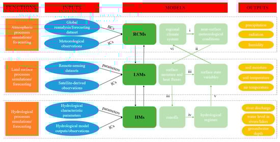
Figure 2.
The flow chart of the two-way coupled atmospheric and hydrological model. In this figure, the abbreviation RCMs signifies regional climate models; LSMs: land surface models; HMs: hydrological models; BCs: boundary conditions; ICs: initial conditions; the roman numbers i–vi: the order in the flow chart of coupled models. It is necessary to clarify that we only list a part of the outputs of the models in this figure.
In recent years, many two-way coupled atmospheric and hydrological models have been developed by coupling higher-resolution hydrology models into RCMs. These fully coupled models mainly include:
- (1)
- PR.WRF is an atmosphere–land surface–hydrology system [28] that combines the regional climate model Weather Research and Forecast Model (WRF), the parallel hydrology model ParFlow, and the land surface model Noah LSM, which connect WRF and ParFlow as an interface. In PR.WRF, ParFlow simulates three-dimensional surface and subsurface soil water movement, which entirely replaces the surface soil moisture simulation in Noah LSM;
- (2)
- TerrSysMP is a highly modular and scale-consistent terrestrial systems modeling platform [29], which consists of an atmospheric model Consortium for Small-Scale Modeling (COSMO), a land surface model CLM, and a three-dimensional variably saturated groundwater flow model ParFlow. In TerrSysMP, the land surface and groundwater model run at higher resolution in a mosaic mode to represent the heterogeneity of land cover, soil texture, and topography;
- (3)
- HIRHAM-MIKE SHE is a dynamically coupled climate–hydrological modeling system [40] based on the regional modeling system HIRHAM and a comprehensive hydrological modelling system MIKE SHE. In HIRHAM-MIKE SHE, the feedback between the groundwater, the land surface and the atmosphere occurs across a range of scales;
- (4)
- WRF-Hydro is a coupled model formed by including channel routing models and groundwater models through an extension package in the regional climate model WRF [30]. The WRF-Hydro simulates land surface hydrological processes, energy states and fluxes at high resolution (typically at 1 km or less);
- (5)
- WRF-HMS [31] and AHMS [32] are mesoscale modeling systems, integrating a mesoscale distributed hydrological model HMS into the regional climate model WRF. In WRF-HMS and AHMS, HMS explicitly simulates terrestrial hydrological processes and lateral groundwater movement, as well as groundwater–unsaturated zone interaction, which replaces the free drainage bottom boundary in WRF’s Noah LSM;
- (6)
- WRF-PUCM-PF is a fully coupled urban atmospheric–hydrological model [42], which consists of the regional climate model WRF in the large-eddy simulation model (LES), the Princeton Urban Canopy model (PUCM), and the subsurface hydrology model ParFlow. It was applied to simulate atmospheric–hydrological processes with shallow groundwater in urban areas;
- (7)
- HGS-WRF is a state-of-the-art water cycle model [41], coupling a 3D control–volume finite element surface and variably saturated subsurface flow model HydroGeoSphere (HGS) into the regional climate model WRF. In HGS-WRF, surface moisture fluxes (e.g., actual evapotranspiration) and surface state (e.g., soil saturation) are calculated in HGS and passed to WRF, while atmospheric conditions are simulated in WRF and partly passed to HGS (such as precipitation and potential evapotranspiration).
3. Application of Two-Way Coupled Atmospheric and Hydrological Models
In fully coupled atmospheric and hydrological models, hydrological enhancement mainly includes the explicit representation of the lateral surface and subsurface water transport, with the possible redistribution of moisture to neighboring soil columns and re-infiltration of routed surface water [63], in addition to some one-way modeled processes such as channel routing and baseflow. Accordingly, the fully coupled atmospheric and hydrological models offer an opportunity for modeling a complete regional water cycle, from the top of the atmosphere, via the boundary layer, to the land surface, the unsaturated zone, and the flow in the river beds [11]. Their applications involve hydrometeorological simulation and forecasts [64,65], atmosphere–hydrology interactions [4,66], water resources management [67], climate response to anthropogenic activities [68,69], etc.
3.1. Hydro-Meteorological Simulations and Forecasts
Among the two-way coupled models, the WRF-Hydro model is one of the most popular models used for weather research and hydrological forecasts around the globe. It’s benefits include: (1) WRF is an integrated modeling platform with an open source, detailed technique guide and rich practical experience accumulated from users; (2) as a physically based, fully distributed, multi-parameterization modeling system, the extension hydrological model [30] is easy to couple with WRF; (3) it has potential for flood forecasting in small and medium catchments, with high spatial resolutions (typically 1 km or less).
Many researchers have used the WRF-Hydro model to carry out hydrometeorology modeling and forecasting, especially in regions with sparse data [70]. For example, Gu et al. [71] used the WRF-Hydro to conduct flood simulations in the Qingjiang River Basin (at a resolution of 1 km in LSM and 100 m in hydrological model) based on European Centre for Medium-Range Weather Forecasts (ECMWF) reanalysis data; with calibrated parameters, the Nash–Sutcliffe efficiency (NSE) of simulated floods ranges from 0.50 to 0.94. Galanaki et al. [72] implemented the WRF-Hydro to simulate flood events in two drainage areas of Attica, Greece, and the results show that the model can reproduce the river discharge after adequately calibrating for the studied basins. Kerandi et al. [65] used the WRF-Hydro for hydrometeorological simulations in the Tana River basin of Kenya, East Africa, driven by ERA-Interim data; the model can effectively estimate annual runoff, but it underestimates peak flow (the NSE is 0.02) at the daily scale. Senatore et al. [63] firstly used the offline WRF-Hydro model to calibrate hydrological parameters, and then used the WRF-Hydro for a three-year simulation in the Crati River Basin of Southern Italy. Ryu et al. [73] applied the WRF-Hydro for flash flood forecasting in the Namgang Dam basin of South Korea; the results show a potential for the WRF-Hydro with optimized parameters to predict heavy rain-induced flash floods. Li et al. [74] utilized the WRF-Hydro to simulate the atmospheric and hydrological processes in the Three-River source region, showing an NSE of 0.55 in comparison to the observed daily discharge. Fersch et al. [75] used the offline WRF-Hydro model to calibrate parameters (with NSEs between 0.56 and 0.64), and then used the WRF-Hydro to reproduce the regional water cycle with calibrated parameters.
The applications of the raw WRF-Hydro show a relatively low accuracy in hydrometeorological simulations and forecasts. Apart from calibrating hydrological parameters, the accuracy of the WRF-Hydro is also influenced by the rainfall forecasting accuracy in the WRF, and the physics mechanisms of hydrology models [76]. Therefore, some approaches, e.g., multi-source precipitation data merging, data assimilation and hydrology model structure revision, have been used to improve hydrological modeling and forecasting accuracy.
As precipitation is the main data used to drive hydrology models, some researchers [64,77,78] improved the accuracy of hydrometeorological simulations by merging multi-source precipitation data (e.g., satellite retrieval precipitation, radar-based estimation precipitation products, and reanalysis precipitation data). For example, Gao et al. [77] have found that merging different-source precipitation products (including reanalysis datasets, ground-based observations, and radar datasets) contributed to improving the WRF-Hydro’s ability in simulating runoff and hydrograph, with an NSE exceeding 0.70 in the Zhanghe River Basin of China. Sun et al. [64] assessed the performance of the WRF-Hydro with different forcing inputs, including Global Land Data Assimilation System (GLDAS) products, WRF, ideal forcings, and observed and merged rainfalls. The results show that the capacity of the WRF-Hydro model to predict floods was comparable to that of the Xinanjiang model when driven by GLDAS forcings with observed rainfall, WRF forcings with observed rainfall, and GLDAS forcings with GLDAS-merged rainfall.
The structure in hydrology models varies between different models, since the developers may have distinctive thoughts on how to interpret hydrological processes, and models are developed in regions with unique hydrological characteristics and regimes [79]. Some researchers have made achievements in improving the simulation accuracy of the WRF-Hydro by modifying the model structure [76,78,80]. For example, Wang et al. [76] improved the rainfall–runoff structure of the WRF-Hydro via a complicated rainfall–runoff transformation mechanism in the mixed runoff generation regions. The improved WRF-Hydro was more effective in simulating floods with high peaks and steep rises and falls. Chao et al. [78] used the WRF-Hydro-RAPID model that additionally includes a vector-based flow routing module for flood simulations in the Daheba Watershed, China. With merged precipitation data, the WRF-Hydro-RAPID model better forecasted and simulated the floods in the Daheba Watershed. Moreover, in space, the model has consistent performance. Tian et al. [81] integrated a conceptual rainfall–runoff model (with two modes: gridded and lumped) in the WRF-Hydro to describe a mixed runoff generation mechanism. The applications at two small- and medium-scale sub-watersheds in northern China demonstrated that the lumped system performs well for storm events with uniform spatial distribution.
Data assimilation is another approach to improving hydrometeorological forecasts, by providing more reliable initial atmospheric and hydrological conditions. For example, Tian et al. [80] used the WRF three-dimensional variational (3DVar) data assimilation method to assimilate conventional observations and radar reflectivity data to update the initial and lateral boundary conditions in the WRF model, and further, to provide more accurate rainfall forecasts. The applications on four storm events in two mountainous catchments of Northern China indicated that the WRF-Hydro with data assimilation provided satisfactory flood forecasts, especially for storm events with relatively even rainfall distributions in the spatial dimension. Kim et al. [82] used the WRF-Hydro and data assimilation of streamflow observations to predict urban floods in the Dallas–Fort Worth area, and their results manifested that using data assimilation to initialize the WRF-Hydro model is necessary, especially when there is a lack of high-quality calibration and a continuous simulation of streamflow.
3.2. Feedback of Terrestrial Water Flows to the Atmosphere
It was found that representing surface runoff can considerably affect soil moisture, surface water and energy balance in LSMs [47,54,83]; however, the generated runoff disappears from LSM grids without overland and channel routing. Due to the integration of hydrology models, the fully coupled atmospheric and hydrological models can simulate lateral surface water movement and its feedback to the atmosphere.
Two-way coupling atmospheric–hydrological simulations in short time periods were used to study the impact of hydrological enhancement on the atmospheric boundary layer (e.g., convective precipitation). For example, Forrester et al. [84] explored the impact of hydrological representation on the atmospheric boundary layer (ABL) by comparing standalone WRF simulations and different coupled PF.WRF simulations during summer time in the Colorado Rocky Mountain headwater region. They found that lateral groundwater transport affects low-level moisture convection, which may strengthen anabatic mountain–valley circulation. Sulis et al. [85] used two coupled modeling platforms, PF.WRF and TerrSysMP, to simulate soil–vegetation–atmosphere interactions. The simulations over the North Rhine–Westphalia region of western Germany presented strong convective precipitation in two coupled models. Moreover, there is clear similarity in the sensitivity of the simulated local convective events to the perturbed soil moisture initial conditions for both models. Arnault et al. [66] used the WRF-Hydro-tag to study the contribution of lateral terrestrial water flow to summer precipitation (June–September 2008) in different climatic regions (e.g., Europe and West Africa). It was found that lateral terrestrial water flow makes the relative contribution of land surface evaporation to precipitation increase by 3.6% in Europe and 5.6% in West Africa, which is small but non-negligible. Sulis et al. [86] used the terrestrial system modeling platform TerrSysMP to simulate 3D water flowing in the atmosphere and the subsurface in April–May 2013 over western Germany. Probably due to the strong influence of the large-scale synoptic conditions in the studied region, the coupled model failed to improve precipitation and temperature prediction as expected, in spite of physically based and more detailed hydrometeorological processes and feedbacks.
Through comparing coupled and standalone long-term hydrometeorological simulations, researchers have found that the terrestrial water flows can change water cycling and influence regional climate at seasonal or longer time scales. For example, Senatore et al. [63] applied the WRF-Hydro modeling system to carry out a three-year simulation in the Crati River Basin of Italy, and further compared it to the standalone WRF simulation. Although main rain events in the studied basin are mostly caused by the interactions between the atmosphere and the surrounding Mediterranean Sea, the fully coupled model performed better than the standalone WRF with respect to observed precipitation. The reason is that it enables more water to circulate in the modeled regional water cycle, and modifies long-term land surface hydrological processes by redistributing and reinfiltrating local infiltration–excess runoff. Zhang et al. [14] used the WRF-Hydro for three-year simulations with and without coupling in the Heihe River Basin of northwestern China. In the fully coupled mode, the lateral terrestrial water flow can redistribute infiltration–excess runoff in the mountainous area, resulting in higher soil moisture content in the root zone. The resulting wetting and cooling in the near surface changes regional water vapor and its transports, and further affects regional climate. Arnault et al. [11] applied the WRF-Hydro model in simulating the complete hydrometeorological water cycle from March 2003 to February 2004 in West Africa. By comparison of the WRF and WRF-Hydro simulation results, they found that overland flow-induced changes in runoff–infiltration partitioning and land–atmosphere feedback mechanisms are much greater for simulated areas large enough to resolve mesoscale convective systems’ life cycles.
3.3. Groundwater-Atmosphere Interactions
By representing aquifers and/or groundwater tables in LSMs and climate models, the influences of groundwater tables and/or aquifers on the atmosphere have been studied thoroughly in the past decades. The aquifer–atmosphere interaction mainly relies on the fact that the groundwater in aquifers can interact with surface soil profile vertically, increasing soil moisture and local water supply to the atmosphere. For example, Liang et al. [53] found that a simulation with surface and groundwater interactions presented wetter soil moisture in the lower soil layer. Niu et al. [26] found that representing groundwater can produce a much wetter soil profile and up to 16% more annual evapotranspiration; Yuan et al. [27] found that incorporating the water table dynamics results in wetter soil in the top and root zone soil layers and enhances bare soil evaporation. Simulations in the Mill Creek Watershed, northeastern Kansas, showed that 5~20% of evapotranspiration is from the aquifer, and the fraction is higher in drier years [56].
When representing groundwater dynamics and lateral subsurface flows in LSMs, the key influence is that subsurface flows can redistribute the spatial pattern of soil moisture, and hence potentially affect surface atmospheric processes. For example, Seuffert et al. [35] found that the lateral soil water transport between neighboring soil columns in a local climate model can redistribute soil moisture and affect evaporation and precipitation. Maxwell et al. [25] pointed out that there are spatial and temporal correlations between atmospheric variables (in the surface and lower atmosphere) and water table depth in a coupled simulation. The local aquifer–atmosphere interactions make the effects of water table dynamics on regional climate function; meanwhile, the circulation changes are affected by the ambient aquifer–atmosphere interaction [27]. Through numerical simulations, Jr. Gutowski et al. [57] found that water redistributed by the aquifer–river network at times can raise the water table to the vegetation root zone and increase evapotranspiration. Instead of simply representing subsurface flows, the integration of groundwater models (e.g., ParFlow, MODFLOW [87]) contributes to explicitly describing the lateral subsurface water transport, and the further interaction between surface water and soil water in the climate models. This enables us to investigate the influence of lateral groundwater transport with respect to a complete water cycling. For example, Butts et al. [40] applied a dynamically coupled climate–hydrological modeling system HIRHAM-MIKE SHE in a one-year simulation in a managed groundwater-dominated catchment, the Skjern River, Denmark. The coupled and uncoupled simulations show significant seasonal differences, especially for summer precipitation and evapotranspiration, but net precipitation was small. Larsen et al. [13] used a fully coupled regional climate model HIRHAM and a distributed hydrological model MIKE SHE to assess the influence of groundwater on the land surface–atmosphere feedbacks in Kansas, USA. They found a clear correlation between groundwater depth and evapotranspiration in areas with a shallow groundwater table (0.5–3 m). Anyah et al. [88] used a coupled regional climate–hydrologic modeling system RAMS-Hydro to study the influence of groundwater on coupled land–atmosphere. They found that in an arid region, the groundwater table resulted in higher evapotranspiration and greater convective precipitation, while in the more humid regions, the effects of large-scale moisture convergence tended to dominate, and the effects of the water table were obscured. Keune et al. [12] used the coupled modeling system TerrSysMP to study the impact of 3D groundwater dynamics in regional climate simulations. The results show that the groundwater representation significantly impacts land surface–atmosphere processes, especially in regions with shallow water table depth, the largest differences being observed between configurations. Forrester et al. [84] explored the impact of hydrological representation on the atmospheric boundary layer (ABL) by comparing standalone WRF simulations and different coupled PF.WRF simulations during summer time in the Colorado Rocky Mountain headwater region. They found that lateral groundwater transport affects low-level moisture convection, which may strengthen anabatic mountain–valley circulation. Rahman et al. [89] applied a fully coupled subsurface–land surface–atmosphere model to a 150 km × 150 km area in western Germany to simulate two convective precipitation events. The results demonstrate that the groundwater table dynamics affect atmospheric simulation, especially under strong convective conditions, and neglecting this may introduce systematic uncertainties. Larsen et al. [90] conducted a six-year coupled simulation and a standalone atmospheric simulation over the Skjern River catchment, individually, and the comparison showed a high degree of local influence on the atmosphere. They explained that this is mainly because more completely representing subsurface processes can substantially improve precipitation dynamics at seasonal and longer time scales.
4. Challenges and Opportunities
4.1. Difficulties and Challenges
As stated above, the fully coupled atmospheric and hydrological models have been undergoing rapid development, but still come with challenges.
- (1)
- Calibrating hydrological parameters. In hydrology models, some hydrological parameters are determined by calibration, which is relatively simple for statistical empirically based hydrology modeling [3,91,92]. However, for coupled atmospheric and hydrological models, parameter calibration is largely computational and time-consuming, and it is still difficult to obtain global- or continental-scale parameter datasets for high-resolution hydrology models, although some hydrological parameter datasets are available for large-scale hydrology models (e.g., the macro-scale VIC model [93]). Therefore, it may be necessary to develop quick-calibrating hydrological parameters for physically based models, combined with new techniques such as deep learning [94];
- (2)
- Describing physical mechanisms at high resolutions. The current fully coupled atmospheric and hydrological models are usually applied at high or super-high resolutions (less than 1 km). Hence, it is important to understand the physical mechanisms with high-resolution monitoring of the underlying surface, e.g., the interactions between the atmospheric and hydrological processes and between the surface and the subsurface [95,96]. Singh et al. [97] simulated the changes in drainage, runoff, and infiltration using finer hillslope scales (~100 m) in CLM v4.0, and they found that the description of hydrological processes at super-high resolutions can significantly alter results;
- (3)
- The limitations in simulation domain and period. High- or superhigh-resolution hydrometeorological simulations are key study topics, but this requires powerful computational ability and a large number of datasets to support it. In this case, the high-resolution hydrometeorological simulations were carried out mainly for small domains/watersheds [28,70] or short time periods [72,73]. It might be difficult to reflect the influence of hydrological processes on the atmosphere at large spatiotemporal scales, hence we need to pay more attention to hydrometeorological studies over longer time scales [84] and larger catchment scales [31,32];
- (4)
- Improving parameterization schemes. One motivation in developing coupled atmospheric and hydrological models is to improve parameterization schemes for water cycling processes, and then enhance simulating and forecasting accuracy. Some human activities, e.g., reservoir impounding and regulation, groundwater extraction and irrigation, can significantly alter hydrological processes and the water cycle [98,99,100,101,102,103]. The interactions and feedbacks between anthropogenic activities and hydrometeorological processes have been one of the frontier fields of scientific water research. Therefore, describing the anthropogenic redistribution of water resources using parameterization schemes is one important means of improving land surface models and hydrology models [69,104,105].
4.2. Opportunities and Outlooks
Different from statistical empirically based hydrology models, which must be calibrated with observations, two-way coupled atmospheric and hydrological models are physically based and use parameters with explicit physical meanings. In coupled models, hydrological models focus on simulating two- and three-dimensional hydrological processes based on high-resolution meteorological and underlying surface conditions, as well as hydrological characteristic parameters. For example, RCMs can properly simulate some localized atmospheric processes, such as orographic and convectional rain, as well as the locations, which helps to forecast intense storm events as well as the responding hydrological processes. The fully coupled atmospheric and hydrological models show higher potential for use in accurately simulating and forecasting hydrological processes, especially for more unstable climate systems and extreme hydrological events.
Fully coupled atmospheric and hydrological models simulate atmospheric processes and lateral surface and subsurface water transport dependently, and exchange variables between atmospheric models and hydrology models. Unlike the one-way coupling approach, wherein hydrology models are externally driven by forced meteorological conditions, the two-way coupling approach enables the simulation of catchment-scale hydrological processes and altered water cycle-related variables in climate models. These occur throughout the entire simulation period and the whole simulation domain. This contributes to revising simulating atmospheric processes and improving the accuracy of hydrometeorological forecasting, which shows great potential in forecasting floods and droughts in future.
Due to increasingly enhanced anthropogenic perturbation, the anthropogenic impacts on the terrestrial water cycle have gained more and more attention. The redistribution of water resources by anthropogenic activities can change hydrological processes (e.g., change of flood magnitude and timing by reservoir impounding and regulation, decrease in groundwater table caused by groundwater withdrawal) and land surface processes (e.g., increase in evapotranspiration and alteration of energy exchange by irrigation). By representing water impounding and withdrawal (i.e., reservoir and lake impounding, groundwater extraction) in hydrological models, and water transfer and utilization in LSMs (e.g., irrigation, land use cover change), the consequent coupled atmospheric and hydrological models will be made into powerful tools to study the changing water cycling processes in the context of climate change and human activities.
Author Contributions
Q.X.: conceptualization, formal analysis, investigation, writing—original draft. Y.F.: formal analysis and writing—review and editing. H.Z. and X.H.: funding acquisition. C.J. and Y.W.: investigation and writing—review and editing. D.L.: writing—review and editing. All authors have read and agreed to the published version of the manuscript.
Funding
This research was funded by the Young Scientists Fund of the National Natural Science Foundation of China (Grant No. 52109030), the Open Fund Project of Hubei Key Laboratory of Intelligent Yangtze and Hydroelectric Science (Grant No. 242102006), and the financial project of Hubei province (Grant No. 2020-218-004-001).
Institutional Review Board Statement
Not applicable.
Informed Consent Statement
Not applicable.
Data Availability Statement
No new data were created or analyzed in this study. Data sharing is not applicable to this article.
Acknowledgments
We thank Yaping Shao, University of Cologne, Germany for the suggestions and review.
Conflicts of Interest
The authors declare no conflict of interest.
References
- Mölders, N.; Raabe, A. Testing the Effect of a Two-Way-Coupling of a Meteorological and a Hydrologic Model On the Predicted Local Weather. Atmos. Res. 1997, 45, 81–107. [Google Scholar] [CrossRef]
- Miller, J.R.; Russell, G.L.; Caliri, G. Continental-Scale River Flow in Climate Models. J. Clim. 1994, 7, 914–928. [Google Scholar] [CrossRef]
- Deng, C.; Liu, P.; Wang, W.; Shao, Q.; Wang, D. Modelling Time-Variant Parameters of a Two-Parameter Monthly Water Balance Model. J. Hydrol. 2019, 573, 918–936. [Google Scholar] [CrossRef]
- Rummler, T.; Arnault, J.; Gochis, D.; Kunstmann, H. Role of Lateral Terrestrial Water Flow on the Regional Water Cycle in a Complex Terrain Region: Investigation with a Fully Coupled Model System. J. Geophys. Res.-Atmos. 2019, 124, 507–529. [Google Scholar] [CrossRef]
- Yang, C.; Yu, Z.; Hao, Z.; Zhang, J.; Zhu, J. Impact of Climate Change on Flood and Drought Events in Huaihe River Basin, China. Hydrol. Res. 2012, 43, 14–22. [Google Scholar] [CrossRef]
- Su, B.; Huang, J.; Fischer, T.; Wang, Y.; Kundzewicz, Z.W.; Zhai, J.; Sun, H.; Wang, A.; Zeng, X.; Wang, G.; et al. Drought Losses in China Might Double Between the 1.5 Degrees C and 2.0 Degrees C Warming. Proc. Natl. Acad. Sci. USA 2018, 115, 10600–10605. [Google Scholar] [CrossRef]
- Meza, I.; Siebert, S.; Döll, P.; Kusche, J.; Herbert, C.; Eyshi Rezaei, E.; Nouri, H.; Gerdener, H.; Popat, E.; Frischen, J.; et al. Global-Scale Drought Risk Assessment for Agricultural Systems. Nat. Hazards Earth Syst. Sci. 2020, 20, 695–712. [Google Scholar] [CrossRef]
- Wada, Y.; van Beek, L.P.H.; Wanders, N.; Bierkens, M.F.P. Human Water Consumption Intensifies Hydrological Drought Worldwide. Env. Res. Lett. 2013, 8, 34036. [Google Scholar] [CrossRef]
- Zhang, D.; Zhang, Q.; Qiu, J.; Bai, P.; Liang, K.; Li, X. Intensification of Hydrological Drought Due to Human Activity in the Middle Reaches of the Yangtze River, China. Sci. Total. Environ. 2018, 637–638, 1432–1442. [Google Scholar] [CrossRef]
- Margariti, J.; Rangecroft, S.; Parry, S.; Wendt, D.E.; Van Loon, A.F. Anthropogenic Activities Alter Drought Termination. Elem. Sci. Anthr. 2019, 7, 27. [Google Scholar] [CrossRef]
- Arnault, J.; Wagner, S.; Rummler, T.; Fersch, B.; Kunstmann, H. Role of Runoff–Infiltration Partitioning and Resolved Overland Flow on Land–Atmosphere Feedbacks: A Case Study with the Wrf-Hydro Coupled Modeling System for West Africa. J. Hydrometeorol. 2016, 17, 1489–1516. [Google Scholar] [CrossRef]
- Keune, J.; Gasper, F.; Goergen, K.; Hense, A.; Shrestha, P.; Sulis, M.; Kollet, S. Studying the Influence of Groundwater Representations on Land Surface-Atmosphere Feedbacks During the European Heat Wave in 2003. J. Geophys. Res. Atmos. 2016, 121, 13301–13325. [Google Scholar] [CrossRef]
- Larsen, M.; Rasmussen, S.; Drews, M.; Butts, M.; Christensen, J.; Refsgaard, J. Assessing the Influence of Groundwater and Land Surface Scheme in the Modelling of Land Surface-Atmosphere Feedbacks Over the Fife Area in Kansas, USA. Environ. Earth Sci. 2016, 75, 130. [Google Scholar] [CrossRef]
- Zhang, Z.; Arnault, J.; Wagner, S.; Laux, P.; Kunstmann, H. Impact of Lateral Terrestrial Water Flow On Land-Atmosphere Interactions in the Heihe River Basin in China: Fully Coupled Modeling and Precipitation Recycling Analysis. J. Geophys. Res.-Atmos. 2019, 124, 8401–8423. [Google Scholar] [CrossRef]
- Manabe, S.; Smagorinsky, J.; Strickler, R.F. Simulated Climatology of a General Circulation Model with a Hydrologic Cycle. Mon. Weather Rev. 1965, 93, 769–798. [Google Scholar] [CrossRef]
- Shao, Y.; Henderson-Sellers, A. Validation of Soil Moisture Simulation in Landsurface Parameterisation Schemes with Hapex Data. Glob. Planet. Chang. 1996, 13, 11–46. [Google Scholar] [CrossRef]
- Liang, X.; Wood, E.F.; Lettenmaier, D.P.; Lohmann, D.; Boone, A.; Chang, S.; Chen, F.; Dai, Y.; Desborough, C.; Dickinson, R.E.; et al. The Project for Intercomparison of Land-Surface Parameterization Schemes (Pilps) Phase 2(C) Red-Arkansas River Basin Experiment: 2. Spatial and Temporal Analysis of Energy Fluxes. Glob. Planet. Chang. 1998, 19, 137–159. [Google Scholar] [CrossRef]
- Lohmann, D.; Lettenmaier, D.P.; Liang, X.; Wood, E.F.; Boone, A.; Chang, S.; Chen, F.; Dai, Y.; Desborough, C.; Dickinson, R.E.; et al. The Project for Intercomparison of Land-Surface Parameterization Schemes (Pilps) Phase 2(C) Red–Arkansas River Basin Experiment: 3. Spatial and Temporal Analysis of Water Fluxes. Glob. Planet. Chang. 1998, 19, 161–179. [Google Scholar] [CrossRef]
- Wood, E.F.; Lettenmaier, D.P.; Liang, X.; Lohmann, D.; Boone, A.; Chang, S.; Chen, F.; Dai, Y.; Dickinson, R.E.; Duan, Q.; et al. The Project for Intercomparison of Land-Surface Parameterization Schemes (Pilps) Phase 2(C) Red–Arkansas River Basin Experiment: 1. Experiment Description and Summary Intercomparisons. Glob. Planet. Chang. 1998, 19, 115–135. [Google Scholar] [CrossRef]
- Dickinson, R.E.; Henderson-Sellers, A.; Kennedy, P.J. Biosphere-Atmosphere Transfer Scheme (Bats) Version Le as Coupled to the Ncar Community Climate Model; Technical Note. [Ncar (National Center for Atmospheric Research)]; National Center for Atmospheric Research: Boulder, CO, USA, 1993. [Google Scholar]
- Dai, Y.; Zeng, X.; Dickinson, R.E.; Baker, I.; Bonan, G.B.; Bosilovich, M.G.; Denning, A.S.; Dirmeyer, P.A.; Houser, P.R.; Niu, G.; et al. The Common Land Model. B Am. Meteorol. Soc. 2003, 84, 1013–1024. [Google Scholar] [CrossRef]
- Liang, X.; Wood, E.F.; Lettenmaier, D.P. Surface Soil Moisture Parameterization of the Vic-2L Model: Evaluation and Modification. Glob. Planet. Chang. 1996, 13, 195–206. [Google Scholar] [CrossRef]
- Beven, K.J.; Kirkby, M.J. A Physically Based, Variable Contributing Area Model of Basin Hydrology/Un Modèle À Base Physique De Zone D’appel Variable De L’hydrologie Du Bassin Versant. Hydrol. Sci. J. 1979, 24, 43–69. [Google Scholar] [CrossRef]
- Ning, L.; Zhan, C.; Luo, Y.; Wang, Y.; Liu, L. A Review of Fully Coupled Atmosphere-Hydrology Simulations. J. Geogr. Sci. 2019, 29, 465–479. [Google Scholar] [CrossRef]
- Maxwell, R.M.; Chow, F.K.; Kollet, S.J. The Groundwater–Land-Surface–Atmosphere Connection: Soil Moisture Effects On the Atmospheric Boundary Layer in Fully-Coupled Simulations. Adv. Water Resour. 2007, 12, 2447–2466. [Google Scholar] [CrossRef]
- Niu, G.; Yang, Z.; Dickinson, R.E.; Gulden, L.E.; Su, H. Development of a Simple Groundwater Model for Use in Climate Models and Evaluation with Gravity Recovery and Climate Experiment Data. J. Geophys. Res. 2007, 112, JD007522. [Google Scholar] [CrossRef]
- Yuan, X.; Xie, Z.; Zheng, J.; Tian, X.; Yang, Z. Effects of Water Table Dynamics On Regional Climate: A Case Study Over East Asian Monsoon Area. J. Geophys. Res.-Atmos. 2008, 113, JD010180. [Google Scholar] [CrossRef]
- Maxwell, R.M.; Lundquist, J.K.; Mirocha, J.D.; Smith, S.G.; Woodward, C.S.; Tompson, A.F.B. Development of a Coupled Groundwater–Atmosphere Model. Mon. Weather Rev. 2011, 1, 96–116. [Google Scholar] [CrossRef]
- Shrestha, P.; Sulis, M.; Masbou, M.; Kollet, S.; Simmer, C. A Scale-Consistent Terrestrial Systems Modeling Platform Based On Cosmo, Clm, and Parflow. Mon. Weather Rev. 2014, 142, 3466–3483. [Google Scholar] [CrossRef]
- Gochis, D.; Yu, W.; Yates, D. The Wrf-Hydro Model Technical Description and User’s Guide; Version 3.0; NCAR Technical Document; NCAR: Boulder, CO, USA, 2015; p. 120. [Google Scholar]
- Wagner, S.; Fersch, B.; Yuan, F.; Yu, Z.; Kunstmann, H. Fully Coupled Atmospheric-Hydrological Modeling at Regional and Long-Term Scales: Development, Application, and Analysis of Wrf-Hms. Water Resour. Res. 2016, 52, 3187–3211. [Google Scholar] [CrossRef]
- Xia, Q. Development and Application of a Coupled Atmospheric and Hydrological Modelling System. Ph.D. Thesis, University of Cologne, Cologne, Germany, 2019. [Google Scholar]
- Haddeland, I.; Clark, D.; Franssen, W.H.P.; Ludwig, F.; Voss, F.; Arnell, N.W.; Bertrand, N.; Best, M.; Folwell, S.; Gerten, D.; et al. Multimodel Estimate of the Global Terrestrial Water Balance: Setup and First Results. J. Hydrometeorol. 2011, 5, 869–884. [Google Scholar] [CrossRef]
- Sharma, P.J.; Patel, P.L.; Jothiprakash, V. Impact of Rainfall Variability and Anthropogenic Activities On Streamflow Changes and Water Stress Conditions Across Tapi Basin in India. Sci. Total Environ. 2019, 687, 885–897. [Google Scholar] [CrossRef]
- Seuffert, G.; Gross, P.; Simmer, C.; Wood, E.F. The Influence of Hydrologic Modeling On the Predicted Local Weather: Two-Way Coupling of a Mesoscale Weather Prediction Model and a Land Surface Hydrologic Model. J. Hydrometeorol. 2002, 5, 505–523. [Google Scholar] [CrossRef]
- Maxwell, R.M.; Miller, N.L. Development of a Coupled Land Surface and Groundwater Model. J. Hydrometeorol. 2005, 3, 233–247. [Google Scholar] [CrossRef]
- Niu, G.; Yang, Z.; Dickinson, R.E.; Gulden, L.E. A Simple Topmodel-Based Runoff Parameterization (Simtop) for Use in Global Climate Models. J. Geophys. Res.-Atmos. 2005, 110, JD006111. [Google Scholar] [CrossRef]
- Tian, X.; Xie, Z.; Zhang, S.; Liang, M. A Subsurface Runoff Parameterization with Water Storage and Recharge Based On the Boussinesq-Storage Equation for a Land Surface Model. Sci. China Ser. D Earth Sci. 2006, 49, 622–631. [Google Scholar] [CrossRef]
- Lawrence, D.M.; Fisher, R.A.; Koven, C.D.; Oleson, K.W.; Swenson, S.C.; Bonan, G.; Collier, N.; Ghimire, B.; van Kampenhout, L. The Community Land Model Version 5: Description of New Features, Benchmarking, and Impact of Forcing Uncertainty. J. Adv. Model. Earth Syst. 2019, 11, 4245–4287. [Google Scholar] [CrossRef]
- Butts, M.; Drews, M.; Larsen, M.A.D.; Lerer, S.; Rasmussen, S.H.; Grooss, J.; Overgaard, J.; Refsgaard, J.C.; Christensen, O.B.; Christensen, J.H. Embedding Complex Hydrology in the Regional Climate System-Dynamic Coupling Across Different Modelling Domains. Adv. Water Resour. 2014, 74, 166–184. [Google Scholar] [CrossRef]
- Davison, J.H.; Hwang, H.; Sudicky, E.A.; Mallia, D.V.; Lin, J.C. Full Coupling Between the Atmosphere, Surface, and Subsurface for Integrated Hydrologic Simulation. J. Adv. Model. Earth Syst. 2018, 10, 43–53. [Google Scholar] [CrossRef]
- Talebpour, M.; Welty, C.; Bou-Zeid, E. Development and Testing of a Fully-Coupled Subsurface-Land Surface-Atmosphere Hydrometeorological Model: High-Resolution Application in Urban Terrains. Urban Clim. 2021, 40, 100985. [Google Scholar] [CrossRef]
- Warrach, K.; Stieglitz, M.; Mengelkamp, H.; Raschke, E. Advantages of a Topographically Controlled Runoff Simulation in a Soil–Vegetation–Atmosphere Transfer Model. J. Hydrometeorol. 2002, 3, 131–148. [Google Scholar] [CrossRef]
- Koster, R.D.; Suarez, M.J.; Ducharne, A.; Stieglitz, M.; Praveen, K. A Catchment-Based Approach to Modeling Land Surface Processes in a General Circulation Model. 1. Model Structure. J. Geophys. Res.-Atmos. 2000, 105, 809–822. [Google Scholar] [CrossRef]
- Famiglietti, J.S.; Wood, E.F. Multiscale Modeling of Spatially Variable Water and Energy Balance Processes. Water Resour. Res. 1994, 11, 3061–3078. [Google Scholar] [CrossRef]
- Stieglitz, M.; Rind, D.; Famiglietti, J.; Rosenzweig, C. An Efficient Approach to Modeling the Topographic Control of Surface Hydrology for Regional and Global Climate Modeling. J. Clim. 1997, 10, 118–137. [Google Scholar] [CrossRef]
- Niu, G.; Yang, Z.; Mitchell, K.E.; Chen, F.; Ek, M.B.; Barlage, M.; Kumar, A.; Manning, K.; Niyogi, D.; Rosero, E.; et al. The Community Noah Land Surface Model with Multiparameterization Options (Noah-Mp): 1. Model Description and Evaluation with Local-Scale Measurements. J. Geophys. Res. 2011, 116, JD015139. [Google Scholar] [CrossRef]
- Habets, F.; Noilhan, J.; Golaz, C.; Goutorbe, J.P.; Lacarrère, P.; Leblois, E.; Ledoux, E.; Martin, E.; Ottlé, C.; Vidal-Madjar, D. The Isba Surface Scheme in a Macroscale Hydrological Model Applied to the Hapex-Mobilhy Area: Part I: Model and Database. J. Hydrol. 1999, 217, 75–96. [Google Scholar] [CrossRef]
- Habets, F.; Noilhan, J.; Golaz, C.; Goutorbe, J.P.; Lacarrère, P.; Leblois, E.; Ledoux, E.; Martin, E.; Ottlé, C.; Vidal-Madjar, D. The Isba Surface Scheme in a Macroscale Hydrological Model Applied to the Hapex-Mobilhy Area: Part II: Simulation of Streamflows and Annual Water Budget. J. Hydrol. 1999, 217, 97–118. [Google Scholar] [CrossRef]
- Habets, F.; Etchevers, P.; Golaz, C.; Leblois, E.; Ledoux, E.; Martin, E.; Noilhan, J.; Ottle, C. Simulation of the Water Budget and the River Flows of the Rhône Basi. J. Geophys. Res. 1999, 104, 31145–31172. [Google Scholar] [CrossRef]
- Dirmeyer, P.A.; Zeng, F.J.; Ducharne, A.; Morrill, J.C.; Koster, R.D. The Sensitivity of Surface Fluxes to Soil Water Content in Three Land Surface Schemes. J. Hydrometeorol. 2000, 2, 121–134. [Google Scholar] [CrossRef]
- Pal, J.S.; Eltahir, E.A.B. Pathways Relating Soil Moisture Conditions to Future Summer Rainfall within a Model of the Land–Atmosphere System. J. Clim. 2001, 6, 1227–1242. [Google Scholar] [CrossRef]
- Liang, X.; Xie, Z.; Huang, M. A New Parameterization for Surface and Groundwater Interactions Andits Impact On Water Budgets with the Variable Infiltration Capacity (Vic) Land Surface Model. J. Geophys. Res.-Atmos. 2003, 108, JD003090. [Google Scholar] [CrossRef]
- Chen, J.; Kumar, P. Topographic Influence on the Seasonal and Interannual Variation of Water and Energy Balance of Basins in North America. J. Clim. 2001, 9, 1989–2014. [Google Scholar] [CrossRef]
- Yeh, P.J.F.; Elfatih, A.B.E. Representation of Water Table Dynamics in a Land Surface Scheme. Part Ii: Subgrid Variability. J. Clim. 2005, 18, 1881–1901. [Google Scholar] [CrossRef]
- York, J.P.; Person, M.; Gutowski, W.J.; Winter, T.C. Putting Aquifers into Atmospheric Simulation Models: An Example From the Mill Creek Watershed, Northeastern Kansas. Adv. Water Resour. 2002, 2, 221–238. [Google Scholar] [CrossRef]
- Gutowski, I.J., Jr.; Smarty, C.J.V.R.; Person, M.; Tles, Z.O.; Fekete, B.; York, J. A Coupled Land-Atmosphere Simulation Program (Clasp): Calibration and Validation. J. Geophys. Res.-Atmos. 2002, 107, ACL-3. [Google Scholar] [CrossRef]
- Gulden, L.E.; Rosero, E.; Yang, Z.; Rodell, M.; Jackson, C.S.; Niu, G.; Yeh, P.J.F.; Famiglietti, J. Improving Land-Surface Model Hydrology: Is an Explicit Aquifer Model Better than a Deeper Soil Profile? Geophys. Res. Lett. 2007, 34, GL029804. [Google Scholar] [CrossRef]
- Kollet, S.J.; Maxwell, R.M. Capturing the Influence of Groundwater Dynamics on Land Surface Processes Using an Integrated, Distributed Watershed Model. Water Resour. Res. 2008, 44, WR006004. [Google Scholar] [CrossRef]
- Wang, A.; Li, K.Y.; Lettenmaier, D.P. Integration of the Variable Infiltration Capacity Model Soil Hydrology Scheme into the Community Land Model. J. Geophys. Res. 2008, 113, JD009246. [Google Scholar] [CrossRef]
- Tian, W.; Li, X.; Cheng, G.D.; Wang, X.S.; Hu, B.X. Coupling a Groundwater Model with a Land Surface Model to Improve Water and Energy Cycle Simulation. Hydrol. Earth Syst. Sci. 2012, 16, 4707–4723. [Google Scholar] [CrossRef]
- Fan, Y.; Miguez-Macho, G.; Weaver, C.P.; Walko, R.; Robock, A. Incorporating Water Table Dynamics in Climate Modeling: 1. Water Table Observations and Equilibrium Water Table Simulations. J. Geophys. Res. 2007, 112, JD008111. [Google Scholar] [CrossRef]
- Senatore, A.; Mendicino, G.; Gochis, D.J.; Yu, W.; Yates, D.N.; Kunstmann, H. Fully Coupled Atmosphere-Hydrology Simulations for the Central Mediterranean: Impact of Enhanced Hydrological Parameterization for Short and Long Time Scales. J. Adv. Model. Earth Syst. 2015, 7, 1693–1715. [Google Scholar] [CrossRef]
- Sun, M.; Li, Z.; Yao, C.; Liu, Z.; Wang, J.; Hou, A.; Zhang, K.; Huo, W.; Liu, M. Evaluation of Flood Prediction Capability of the Wrf-Hydro Model Based On Multiple Forcing Scenarios. Water 2020, 12, 874. [Google Scholar] [CrossRef]
- Kerandi, N.; Arnault, J.; Laux, P.; Wagner, S.; Kitheka, J.; Kunstmann, H. Joint Atmospheric-Terrestrial Water Balances for East Africa: A Wrf-Hydro Case Study for the Upper Tana River Basin. Appl. Clim. 2018, 131, 1337–1355. [Google Scholar] [CrossRef]
- Arnault, J.; Fersch, B.; Rummler, T.; Zhang, Z.; Quenum, G.M.; Wei, J.; Graf, M.; Laux, P.; Kunstmann, H. Lateral Terrestrial Water Flow Contribution to Summer Precipitation at Continental Scale—A Comparison Between Europe and West Africa with Wrf-Hydro-Tag Ensembles. Hydrol. Process. 2021, 35, e14183. [Google Scholar] [CrossRef]
- Naabil, E.; Lamptey, B.L.; Arnault, J.; Olufayo, A.; Kunstmann, H. Water Resources Management Using the Wrf-Hydro Modelling System: Case-Study of the Tono Dam in West Africa. J. Hydrol. Reg. Stud. 2017, 12, 196–209. [Google Scholar] [CrossRef]
- Zou, J.; Xie, Z.; Yu, Y.; Zhan, C.; Sun, Q. Climatic Responses to Anthropogenic Groundwater Exploitation: A Case Study of the Haihe River Basin, Northern China. Clim. Dyn. 2014, 42, 2125–2145. [Google Scholar] [CrossRef]
- Zeng, Y.; Xie, Z.; Zou, J. Hydrologic and Climatic Responses to Global Anthropogenic Groundwater Extraction. J. Clim. 2017, 30, 71–90. [Google Scholar] [CrossRef]
- Wang, J.; Liu, D.; Tian, S.; Hu, Y.; Ma, J.; Wang, L. Coupling Analysis of Short-Term Weather and Runoff in an Arid Lake Basin of China. Reg. Sustain. 2021, 2, 264–279. [Google Scholar] [CrossRef]
- Gu, T.; Chen, Y.; Gao, Y.; Peng, T.; Hu, B. Study of Flood Simulation in Qingjiang River Basin Based On Wrf-Hydro Model. J. China Hydrol. 2021, 41, 63–68. [Google Scholar]
- Galanaki, E.; Lagouvardos, K.; Kotroni, V.; Giannaros, T.; Christos, G. Implementation of Wrf-Hydro at Two Drainage Basins in the Region of Attica, Greece, for Operational Flood Forecasting. Nat. Hazards Earth Syst. Sci. 2020, 21, 1983–2000. [Google Scholar] [CrossRef]
- Ryu, Y.; Lim, Y.; Ji, H.; Park, H.; Chang, E.; Kim, B. Applying a Coupled Hydrometeorological Simulation System to Flash Flood Forecasting Over the Korean Peninsula. Asia-Pac. J. Atmos. Sci. 2017, 53, 421–430. [Google Scholar] [CrossRef]
- Li, G.; Meng, X.; Blyth, E.; Chen, H.; Shu, L.; Li, Z.; Zhao, L.; Ma, Y. Impact of Fully Coupled Hydrology-Atmosphere Processes On Atmosphere Conditions: Investigating the Performance of the Wrf-Hydro Model in the Three River Source Region On the Tibetan Plateau, China. Water 2021, 13, 3409. [Google Scholar] [CrossRef]
- Fersch, B.; Senatore, A.; Adler, B.; Arnault, J.; Mauder, M.; Schneider, K.; Völkschand, I.; Kunstmann, H. High-Resolution Fully Coupled Atmospheric–Hydrological Modeling: A Cross-Compartment Regional Water and Energy Cycle Evaluation. Hydrol. Earth Syst. Sci. 2020, 24, 2457–2481. [Google Scholar] [CrossRef]
- Wang, W.; Liu, J.; Xu, B.; Li, C.; Liu, Y.; Yu, F. A Wrf/Wrf-Hydro Coupling System with an Improved Structure for Rainfall-Runoff Simulation with Mixed Runoff Generation Mechanism. J. Hydrol. 2022, 612, 128049. [Google Scholar] [CrossRef]
- Gao, Y.; Wu, Y.; Peng, T.; Gu, T. Application of Wrf-Hydro for Runoff Simulation Based on Different Rainfall Products: Taking Zhanghe River Basin as an Example. J. Trop. Meteorol. 2020, 36, 299–306. [Google Scholar]
- Chao, L.; Zhang, K.; Yang, Z.; Wang, J.; Lin, P.; Liang, J.; Li, Z.; Gu, Z. Improving Flood Simulation Capability of the Wrf-Hydro-Rapid Model Using a Multi-Source Precipitation Merging Method. J. Hydrol. 2021, 592, 125814. [Google Scholar] [CrossRef]
- Prieto, C.; Kavetski, D.; Le Vine, N.; Álvarez, C.; Medina, R. Identification of Dominant Hydrological Mechanisms Using Bayesian Inference, Multiple Statistical Hypothesis Testing, and Flexible Models. Water Resour. Res. 2021, 57, e2020W–e28338W. [Google Scholar] [CrossRef]
- Tian, J.; Liu, J.; Yan, D.; Ding, L.; Li, C. Ensemble Flood Forecasting Based on a Coupled Atmospheric-Hydrological Modeling System with Data Assimilation. Atmos. Res. 2019, 224, 127–137. [Google Scholar] [CrossRef]
- Tian, J.; Liu, J.; Wang, Y.; Wang, W.; Li, C.; Hu, C. A Coupled Atmospheric–Hydrologic Modeling System with Variable Grid Sizes for Rainfall–Runoff Simulation in Semi-Humid and Semi-Arid Watersheds: How Does the Coupling Scale Affects the Results? Hydrol. Earth Syst. Sci. 2020, 24, 3933–3949. [Google Scholar] [CrossRef]
- Kim, S.; Shen, H.; Noh, S.; Seo, D.; Welles, E.; Pelgrim, E.; Weerts, A.; Lyons, E.; Philips, B. High-Resolution Modeling and Prediction of Urban Floods Using Wrf-Hydro and Data Assimilation. J. Hydrol. 2021, 598, 126236. [Google Scholar] [CrossRef]
- Clark, D.B.; Gedney, N. Representing the Effects of Subgrid Variability of Soil Moisture on Runoff Generation in a Land Surface Model. J. Geophys. Res.-Atmos. 2008, 113, D10111. [Google Scholar] [CrossRef]
- Forrester, M.M.; Maxwell, R.M. Impact of Lateral Groundwater Flow and Subsurface Lower Boundary Conditions on Atmospheric Boundary Layer Development Over Complex Terrain. J. Hydrometeorol. 2020, 21, 1133–1160. [Google Scholar] [CrossRef]
- Sulis, M.; Williams, J.L.; Shrestha, P.; Diederich, M.; Simmer, C.; Kollet, S.J.; Maxwell, R.M. Coupling Groundwater, Vegetation, and Atmospheric Processes: A Comparison of Two Integrated Models. J. Hydrometeorol. 2017, 5, 1489–1511. [Google Scholar] [CrossRef]
- Sulis, M.; Keune, J.; Shrestha, P.; Simmer, C.; Kollet, S.J. Quantifying the Impact of Subsurface-Land Surface Physical Processes On the Predictive Skill of Subseasonal Mesoscale Atmospheric Simulations. J. Geophys. Res.-Atmos. 2018, 123, 9131–9151. [Google Scholar] [CrossRef]
- McDonald, M.G.; Harbaugh, A.W. Chapter a1: A Modular Three-Dimensional Finite-Difference Groundwater Flow Model. In Techniques of Water-Resources Investigations of the United States Geological Survey; United States GPO: Washington, DC, USA, 1988. [Google Scholar]
- Anyah, R.O.; Weaver, C.P.; Miguez-Macho, G.; Fan, Y.; Robock, A. Incorporating Water Table Dynamics in Climate Modeling: 3. Simulated Groundwater Influence on Coupled Land-Atmosphere Variability. J. Geophys. Res. 2008, 113, JD009087. [Google Scholar] [CrossRef]
- Rahman, M.; Sulis, M.; Kollet, S.J. The Subsurface–Land Surface–Atmosphere Connection Under Convective Conditions. Adv. Water Resour. 2015, 83, 240–249. [Google Scholar] [CrossRef]
- Larsen, M.A.D.; Christensen, J.H.; Drews, M.; Butts, M.B.; Refsgaard, J.C. Local Control On Precipitation in a Fully Coupled Climate-Hydrology Model. Sci. Rep. 2016, 6, 22927. [Google Scholar] [CrossRef]
- Zhang, X.; Liu, P.; Zhao, Y.; Deng, C.; Li, Z.; Xiong, M. Error Correction-Based Forecasting of Reservoir Water Levels: Improving Accuracy Over Multiple Lead Times. Environ. Model. Softw. 2018, 104, 27–39. [Google Scholar] [CrossRef]
- Xiong, M.; Liu, P.; Cheng, L.; Deng, C.; Gui, Z.; Zhang, X.; Liu, Y. Identifying Time-Varying Hydrological Model Parameters to Improve Simulation Efficiency by the Ensemble Kalman Filter: A Joint Assimilation of Streamflow and Actual Evapotranspiration. J. Hydrol. 2019, 568, 758–768. [Google Scholar] [CrossRef]
- Oubeidillah, A.A.; Kao, S.C.; Ashfaq, M.; Naz, B.S.; Tootle, G. A Large-Scale, High-Resolution Hydrological Model Parameter Data Set for Climate Change Impact Assessment for the Conterminous Us. Hydrol. Earth Syst. Sci. 2014, 18, 67–84. [Google Scholar] [CrossRef]
- Tsai, W.; Feng, D.; Pan, M.; Beck, H.; Lawson, K.; Yang, Y.; Liu, J.; Shen, C. From Calibration to Parameter Learning: Harnessing the Scaling Effects of Big Data in Geoscientific Modeling. Nat. Commun. 2021, 12, 5988. [Google Scholar] [CrossRef]
- Wood, E.F.; Roundy, J.K.; Troy, T.J.; van Beek, L.P.H.; Bierkens, M.F.P.; Blyth, E.; de Roo, A.; Döll, P.; Ek, M.; Famiglietti, J.; et al. Hyperresolution Global Land Surface Modeling: Meeting a Grand Challenge for Monitoring Earth’s Terrestrial Water. Water Resour. Res. 2011, 47, WR010090. [Google Scholar] [CrossRef]
- Beven, K.; Cloke, H.; Pappenberger, F.; Lamb, R.; Hunter, N. Hyperresolution Information and Hyperresolution Ignorance in Modelling the Hydrology of the Land Surface. Sci. China Earth Sci. 2015, 58, 25–35. [Google Scholar] [CrossRef]
- Singh, R.S.; Reager, J.T.; Miller, N.L.; Famiglietti, J.S. Toward Hyper-Resolution Land-Surface Modeling: The Effects of Fine-Scale Topography and Soil Texture on Clm4.0 Simulations Over the Southwestern U.S. Water Resour. Res. 2015, 51, 2648–2667. [Google Scholar] [CrossRef]
- Döll, P.; Hoffmann-Dobrev, H.; Portmann, F.T.; Siebert, S.; Eicker, A.; Rodell, M.; Strassberg, G.; Scanlon, B.R. Impact of Water Withdrawals from Groundwater and Surface Water On Continental Water Storage Variations. J. Geodyn. 2012, 59–60, 143–156. [Google Scholar] [CrossRef]
- de Graaf, I.E.M.; van Beek, L.P.H.; Wada, Y.; Bierkens, M.F.P. Dynamic Attribution of Global Water Demand to Surface Water and Groundwater Resources: Effects of Abstractions and Return Flows on River Discharges. Adv. Water Resour. 2014, 64, 21–33. [Google Scholar] [CrossRef]
- Leng, G.; Huang, M.; Tang, Q.; Gao, H.; Leung, L.R. Modeling the Effects of Groundwater-Fed Irrigation on Terrestrial Hydrology Over the Conterminous United States. J. Hydrometeorol. 2014, 15, 957–972. [Google Scholar] [CrossRef]
- Condon, L.E.; Atchley, A.L.; Maxwell, R.M. Evapotranspiration Depletes Groundwater Under Warming Over the Contiguous United States. Nat. Commun. 2020, 11, 873. [Google Scholar] [CrossRef]
- Jiang, C.; Parteli, E.J.R.; Xia, Q.; Yin, X.; Shao, Y. A Regional Hydrological Model for Arid and Semi-Arid River Basins with Consideration of Irrigation. Environ. Model. Softw. 2022, 157, 105531. [Google Scholar] [CrossRef]
- Xia, Q.; Liu, P.; Fan, Y.; Cheng, L.; An, R.; Xie, K.; Zhou, L. Representing Irrigation Processes in the Land Surface-Hydrological Model and a Case Study in the Yangtze River Basin, China. J. Adv. Model. Earth Syst. 2022, 14, e2021M–e2653M. [Google Scholar] [CrossRef]
- Zou, J.; Xie, Z.; Zhan, C.; Qin, P.; Sun, Q.; Jia, B.; Xia, J. Effects of Anthropogenic Groundwater Exploitation on Land Surface Processes: A Case Study of the Haihe River Basin, Northern China. J. Hydrol. 2015, 524, 625–641. [Google Scholar] [CrossRef]
- Wang, L.; Xie, Z.; Xie, J.; Zeng, Y.; Liu, S.; Jia, B.; Qin, P.; Li, L.; Wang, B.; Yu, Y.; et al. Implementation of Groundwater Lateral Flow and Human Water Regulation in Cas-Fgoals-G3. J. Geophys. Res.-Atmos. 2020, 125, e2019J–e32289J. [Google Scholar] [CrossRef]
Disclaimer/Publisher’s Note: The statements, opinions and data contained in all publications are solely those of the individual author(s) and contributor(s) and not of MDPI and/or the editor(s). MDPI and/or the editor(s) disclaim responsibility for any injury to people or property resulting from any ideas, methods, instructions or products referred to in the content. |
© 2023 by the authors. Licensee MDPI, Basel, Switzerland. This article is an open access article distributed under the terms and conditions of the Creative Commons Attribution (CC BY) license (https://creativecommons.org/licenses/by/4.0/).