Article

Capitalization of Tourist Resources in the Post-COVID-19 Period—Developing the Chorematic Method for Oltenia Tourist Destination, Romania

by
Ionuț-Adrian Drăguleasa
*,
Amalia Niță
* and
Mirela Mazilu
Geography Department, Faculty of Sciences, University of Craiova, 13 A. I. Cuza Street, 200585 Craiova, Romania
*
Authors to whom correspondence should be addressed.
Sustainability 2023, 15(3), 2018; https://doi.org/10.3390/su15032018
Submission received: 30 December 2022 / Revised: 17 January 2023 / Accepted: 18 January 2023 / Published: 20 January 2023
(This article belongs to the Special Issue Enhancing Sustainable Rural Development through Tourism Strategies)

Abstract

:
The paper aims at adapting the knowledge regarding the capitalization of tourist resources to the method of tourist choremas in the Oltenia region, Romania, thus creating a tool for planning and organizing the geographical space for sustainable development. The tourism choremas method uses the graphic and cartographic modelling of the territory of the South-West Oltenia region, and in a post-COVID-19 period it is important that the research can help in increasing the productivity in tourism, which can lead to higher incomes for managers in the tourism sector and for the locals from different rural/disadvantaged area of the region. GIS (Geographical Information Systems) represents a key element for the future development of tourism in the virtual environment, given the fact that many travellers use virtual electronic systems to see the tourist destination, surroundings, protected areas, accommodation, tourist routes, recreation and entertainment areas (zoos, hunting areas), etc. Choremes of the Oltenia region were created using ArcGIS 10.1 software, showing different entities and a series of attributes (descriptive elements) marked on the created maps as follows: elements of the natural environment (landforms altimetry, hydrographic network, lakes, national parks and reserves, waterfalls); man-made environment (roads, landmarks—churches, monasteries, museums); or conventional delimitations (county boundary, the boundaries of the two areas—Northern and Southern Oltenia). Four successive stages were conducted in order to create the choremes using the GIS software: (1) creating the database for the analysis of the studied destination; (2) processing the statistical data for Northern and Southern Oltenia; (3) the interpretation of the data obtained in correlation with the specialized literature on the capitalization of tourism resources and forms of tourism existing in the region; and (4) cartographic representation. The chorematic maps are represented at the scale of the geographical territory where the study analysis is carried out. The representation of physico-geographical elements, but also of touristic elements, was represented by lines, points and polygons, using the vector and raster spatial data model. The chorematic method proves to be innovative and up-to-date especially for the organization of the tourist space, for the sustainable development of the region and for the tourism research activity in the area.

1. Introduction

Tourism is projected to become one of the world’s largest industries, with international tourist arrivals reaching 1.8 billion by 2030 [1]. The increased level of energy consumption [2,3,4,5] and the consumption of natural resources [6] represent the most important activities that enhance the tourism sector regionally, nationally and internationally.
The COVID-19 virus was a “super-shock” [7], which partially blocked sectors of economic activity around the world. As restrictions imposed by the authorities and time passed, outdoor recreation and accommodations showed signs of recovery post-COVID-19 pandemic [8,9].
Even so, tourists booking different accommodation units (hotels, hostels, tourist villas, tourist cottages, etc.) refer to spatial proximity (i.e., where they can stay closer to recreational and protected areas), or to choosing new outdoor accommodation units (as glamping sites in Vâlcea county, Romania).
This study is the first which aims to explore natural tourism resources using the chorematic method within the South-West Oltenia Development Region, an innovative and totally new research tool.
The development of this research method is based on a series of theories (polarisation theory, network theory, growth pole theory, behavioural theory and cluster theory) [10], and regional tourism development concepts (region, tourism potential, tourist resources, forms of tourism and tourist brand) aiming at the theoretical understanding of these concepts and at practical observation of the inner transformation of the Oltenia region, all of these conducted through the chorematic method.
Chorema is an elementary structure of the geographical space. This has been wrongly regarded as “easy mapping”, whereas this is mainly used as a research method in the spatial analysis of territory and combines geographical theory [11] with a spatial analysis of resources capitalized in tourism (as in the case of the Oltenia region, the main study area of this paper), and with the cartographic modelling of the main natural and national parks and the new tourist accommodation trends, i.e., glamping.
The chorematic diagrams published in the specialized literature are characterized by the fact that they are drawn in two-dimensional vector graphics with no topographic maps as a base, with very little text used in their creation, with area class representations and with the annotations on the maps that are often abbreviated [12].
One of the earliest GIS applications to be implemented in the UK involved the construction of the tourism and recreation information package to assist planning and policy formulation in Scotland [13]. The field of tourism uses GIS techniques such as a decision support tool in many issues, for example visitor flow management, tourism site suitability analysis and selection, impact assessment and sustainable tourism plans [14].
Geospatial (environmental) data can be used to explore conflicts, examine the impact of tourism on the environment, help decision-making [13], examine the human impact on the environment within major protected areas (natural parks and national parks) and the creation of predictive scenarios on possible landslides/floods near the protected areas.
Impact assessment and simulation are increasingly important in tourism development, and GIS techniques can play a role in auditing environmental conditions, examining the suitability of locations for proposed development, identifying conflicting interests [13] and modelling coordination and subordination relationships to regional centres, using the chorematic method.
The Geographical Information System is a tool that enables a better decision-making process by accessing politicians and managers in the development of tourism and the provision of integrated tourist information, for rural areas and also for major protected areas (national parks and natural parks) [15].
In various regions of Europe, nature-based tourism represents a very important and growing economic sector [16]. Thus, nature-based tourism and resource assessment are important to determine the appropriate region when planning a sustainable tourism destination development [17]. Modern tourists of the 21st century are increasingly attracted by protected natural areas that have a special ecological aspect, scientific, cultural, aesthetic and recreational value [18].
The attractiveness of an area in a touristic sense cannot be abstract, but derives from the attractiveness of the attributes of the tourist area (how recreational, interesting, aesthetic and famous it is) [19], but also if it has camping and leisure areas. The advantages and recognized evaluation of tourist resources should contribute significantly to the economic development of the studied regions, and in our case of the Oltenia region [19]. Other studies [20] use spatial modelling based on indices of attractiveness of geographical and touristic attributes to determine the attractiveness of spa destinations. The GIS utilization in tourism studies has become a very helpful tool when assessing different tourism phenomena. For example, there are papers that show the utilization of GIS by different entities and organizations in tourism analyses and its integration with sustainable development [15].
Two proposals for new tourist destinations that can be developed in the Northern Oltenia region were identified and can represent two new tourist products for Romanian travel agencies, with economic benefits for the tourist service providers in the local areas and that can also attract a high number of foreign tourists from Europe. This would have a direct influence on new strategies [19] and development policies regarding tourism in the South-West Oltenia region.
The Oltenia region was chosen as a case study in this research due to the high natural and man-made tourism potential, that is currently capitalized at a lower level within the domestic tourism products developed by travel agencies and specialists (according to the statistical data in terms of tourist flows and the utilization of accommodation capacity in comparison with other regions of Romania). So, the need to develop the region more from a touristic point of view, and to better capitalize the existing tourism potential in the post COVID-19 period, determined to search unconventional and innovative methods for research. Additionally, applying the chorematic method in this region was challenging due to the fact that it was among the first attempts to analyse the space of the region from this perspective because there are no studies in this concern. Thus, using the choremes can reveal a new sense of the space and a better understanding of tourism at a spatial level, in order to develop new tourist destinations and products in the Oltenia that can be competitive on the national market, and also on the international one.
The two research variables are: the willingness of tourists to stay in tourist and agritourism guesthouses—practicing rural tourism in Oltenia; and the second variable is the willingness of tourists to travel to destinations less promoted internationally and, at the same time, to avoid the overcrowding of destinations. Overcrowding is the most recurrent theme, significant and comparable in magnitude [21] across tourist destinations/areas.
This highlights the fact that visitors, regardless of the increase in the number of illnesses, the epidemiological extent of the COVID-19 virus, or the type of accommodation (hotel, tourist cabin, tourist villa, tourist guesthouse, camping, glamping, etc.), prefer outdoor areas and those that provide social distancing [21].

2. Literature Review

Tourist attractions are very important for supporting the development of local and county tourism because they are the basic elements of tourism products [22,23,24].
Natural resources represent the fundamental support for economic growth and the social and touristic development of a county, region or country [25].
Natural resources and economic growth can be considered vital environmental quality improvements within protected areas [26,27,28]. Consequently, natural resources provide the primary source of goods and services for human and tourist activities [6], as well as construction materials for the development of tourism infrastructure within a territory, such as the Oltenia Development Region. An exaggerated consumption of natural tourism resources within protected areas could generate multiple negative effects on the environment (environmental damage). For many decades, there were discussions about environmental degradation, representing a growing concern for the world’s global problems [29].
Within the tourist destination, the Oltenia region, tourist attractions offer new possibilities for leisure, entertainment, animation and relaxation for arriving tourists within the protected areas, to satisfy all primary and secondary travel needs. On the other hand, the variety of accommodation units within the Oltenia region is fundamentally decisive for the growth of local and county tourism, because they offer a varied range of resources specific to the location and to different targets of tourists.
Therefore, the use of infrastructure plays a critical role in the regional tourism development process and the tourist experience. A large number of empirical studies have demonstrated the importance of tourism infrastructure in the development of tourism [30,31,32,33].
According to the empirical studies presented by [34,35], the agglomeration has been identified as a vital factor in the growth of regional tourism. As a result, [36,37] emphasized the importance of simultaneous action between different sectors of activity, which mainly arise from agglomeration and grouping of activities related to tourism. Agglomeration offers notable cost savings and convenience for tourists and, as a result, enhances highly the regional tourism growth [38].
Other agglomerations and areas with intense tourist flows (both Romanians and foreigners) are, according to the National Institute of Statistics in Romania, at the level of 2021: in mountain resorts (Romanians—1,816,197 and foreigners 50,205); other localities and tourist routes (Romanians—1,535,263 and foreigners 103,779); and in the third place there are the seaside resorts (Romanians 1,115,593 and foreigners 26,678).
The mountain resorts are related to many landmarks and attractions in Romania and the most known agglomeration is in Prahova Valley with Bușteni, Azuga and Sinaia resorts. Tourists can visit outstanding tourist attractions (Peleș Castle in Sinaia, Cantacuzino Castle in Bușteni and Babele and the Sphinx in the Bucegi Mountain). Other popular resorts are: Stâna de Vale from the Apuseni Mountains with tourist attractions (Moara Dracului, Bears Cave, etc.); Voineasa, Straja and Rânca with the highest road in Romania, Transalpina, which crosses four counties: Vâlcea, Gorj, Alba and Sibiu; the Bran-Moieciu-Fundata-Râșnov resorts in Brașov county; the resorts in Bucovina, where you can visit the Voroneț, Moldovița, Sucevița, Humor, Putna and Arbore Monasteries (included in UNESCO world heritage); and the resorts in Maramureș (Borșa, Săpânta and Iza Valley) etc.
Ref. [34] found that the growth rate of local tourism depends on locational economies rather than natural tourism resource endowments. Overall, tourism sites can overcome an inadequate local resource base if there are locational economies to support the regional-sustainable tourism industry, such as the Oltenia region [38].
The attractiveness of the natural setting is achieved by several features that individualize its components [39] (Figure 1).
The relaunch of tourism in Romania for tourist destinations in the post-COVID-19 period, and attracting a very large number of foreign tourists, could bring economic and social benefits, but with many changes necessary for sustainable tourism, according to tourism managers [40].
Rural tourism is considered to be a form of tourism that capitalizes the natural resources of rural households, having very strong links between tourism and the rural space [41], between the activities that can be carried out in the heart of the village and the agricultural activities (plant growth and forestry, outside the household).
The landscapes in the rural area are to a large extent the vital reason for rural tourism [41], so without these unique landscapes within each county (especially the mountain area of Northern Oltenia) the tourist accommodation units in rural areas (guesthouses) would not be able to develop agritourism, as they would not have an ecological and sustainable tourism product to sell to consumers.
The analysis of the definitions in the specialized literature reveals four key aspects of rural tourism, which include location, sustainable development, community characteristics and experiences [42], to which we can add natural products (which satisfy tourists’ requirements regarding their commercialization), the appearance of new constructions called “organic farms” and the traditional footprint of each area. Thus, the biggest challenges for the context of the development and ongoing development of rural tourism arise from the problems related to the internal tourism resources of each county/state [42], i.e., there is, first of all, the problem of diminishing these resources within the protected areas, and secondly, there is the problem of the degradation of these tourist resources due to the overcrowding of massive flows of tourists.
Several examples of cities bring new information about urban tourism development and potential, tourism resources especially at regional level in the Central and Eastern Europe. The city of Craiova in the Oltenia region seeks to capitalize on local heritage to create a distinct urban brand and increase the attractiveness of the area for the local community, visitors and why not for potential investors who want to help develop the city’s urban tourism [43]. Consequently, it represents a good practice example of how a county seat wants to become a destination for those tourists looking for new places to visit [43]. The city’s residents were involved in the project of urban revitalization, mentioning what heritage should be capitalized and also what stories should be told about the city of Craiova. Therefore, the authors consider that understanding the perspective of local residents in this way is very important for establishing a clear place identity for the city of Craiova and for increasing its competitiveness as a tourist destination [43] at regional, national and international level.
The cities of Central and Eastern Europe (Prague, Budapest, Bratislava, Ljubljana, Riga, Tallinn and Vilnius) offer many unique historical resources that attract tourists eager to new and unusual experiences. An example is the legacy of communism itself, in the form of monumental public buildings, monuments and working-class housing estates, together with newly developed museums (these present an interface of the communist past) [44]. However, such “communist heritage” [45] in the digitization of the post-COVID-19 period is less appreciated by local populations, being highly attractive to visitors in the region, although it is marketed as being less accessible to foreign tourists [44].
Finally, many states in post-communist Central and Eastern Europe established commemorative museums that aimed to tell the story of persons that suffered under the communist regime. These commemorative museums attempt to encourage visitors to develop empathy for the victims of communist-era violence [46].
In the paper “Meeting the victims of Romanian Communism: young people and empathy in a memorable museum” the focus group respondents argued that empathy is not an automatic response to suffering and instead can be considered as an interaction between museum design and visitor knowledge [46]. Museum exhibits seek to increase feelings of empathy through storytelling, design, and technology to increase emotion and engagement for visitors and tourists [47].
Those who visit museums physically or virtually during the COVID-19 pandemic should make a difference between empathy and sympathy: empathy expresses emotions about the situation presented by the “suffering of others” [47]; and sympathy represents an attraction/affinity that one feels towards a person. Analysing from the supply perspective, the tourist potential of public museums is evaluated in the specialized literature based on six criteria: (1) culture, (2) physical, (3) product, (4) experiential, (5) marketing, (6) leadership [48], and to which we can add promotion, digitization and visitor attraction strategy.
In English, “chorematics” means a cartographic geospatial modelling method that simulates geographic space by creating geometric shapes and schematic graphic designs. The present study aims to create one or more models of spatial development, by using the method of tourist choremas, with figures, shapes and simplified drawings showing the most important elements of the geographical space of the South-West Oltenia region.
The terms “chorème”, coreme [49], choreme, or even the French term “chorème”, if we refer to [50], are derived from the Latin word (choros) meaning region, space or range. Each represented product of the chorematic method is called “chorem” [51] and is represented by a geospatial structure in the form of points, lines, areas, networks etc.
The chorematic method was developed by the French geographer Roger Brunet [52,53,54,55]. He is considered the founder of the term “corematic” (chorème in French and chorem in English from the formal Greek choré and the suffix ème). At the same time, this method was also adopted by other geographers [56,57].
Refs. [58,59,60,61] used this method for database mining and spatial analysis; [62] tried to give the chorematic procedure an objective or systematic character.
In 2001, Roger Brunet sought to develop cartography that expresses the dynamism of the geographical space, by using the chorems method. The hypothesis proposed by the French geographer was the following “as people transform space through their work, they create real structures that can be expressed graphically and cartographically” [63]. These structures are simultaneously a social production, but also a part of society [49] for the development of space and human settlements within a territory.
Space is composed of choremas. Brunet proposed a reference framework (Figure 2) with the following models of geographic figures to represent chorematic structures [63]. These proposed structures, constitute a system of signs to represent choremes and are composed of the intersection of basic graphic elements (corresponding to implementation modes) in columns, with geographic dynamics in lines. His suggestion does not have the same determining force as Graphic Semiology, where the sign is not arbitrary [64]. Representations of choremes are arbitrary or can be made with variations by geographers [63].
Beside the metacartography, meaning the creation of a language for space translated into maps on a conceptual level, developed by Brunet, there are also other methods used in tourism studies as GAM (the geosite assessment model) or M-GAM (the modified geosite assessment model). If a choreme splits the space into sets of units, functional divisions that underline very clearly the main intentions or present a certain system (natural or anthropogenic), the GAM and then M-GAM developed by many researchers (Tomic and Bozic 2014; Tomic et al., 2020; Vukovic and Antic, 2019 cited by [66]) perform a space evaluation based on the tourists and experts’ views applied on different geosites in order to develop the potential of geotourism. Thus, the latter method focusses mainly on two indicators that are divided into 12–15 sub-indicators: the main values, which are generated by the natural properties of the geosite; and the additional values underlining the modifications of the geosite use induced by visitors. The current study focuses on the chorematic method in order to better understand the Oltenia geographical space and to further develop new possibilities for tourism capitalization of the area.
The set of representations can be improved because, in the 21st century, the Geographical Information System (ArcGIS, QGIS) represents a necessity for the spatial representation of geographical elements (natural and anthropic framework).
Consequently, the French cartographer and theorist of information graphics, Jacques Bertin, published Sémiologie graphique: Les diagrammes, les réseaux, les cartes in Paris at Gauthier-Villars’ press in 1967. This book provided the first theoretical foundation for information graphics; a systematic classification of the use of visual elements to display data and relationships in static graphics. Bertin’s 1967 graphic semiology consisted of seven visual variables: (1) position, (2) shape, (3) orientation, (4) colour (hue), (5) texture, (6) value (lightness or darkness of colour) and (7) size, combined with a visual semantics for linking data attributes to visual elements. This paper uses all the symbols when conducting the chorematic method for the Oltenia region.

3. Materials and Methodology

The research methodology is mainly based on the rules, principles, and recommendations formulated by Roger Brunet (2001) and models of geographic figures to represent chorematic structures; also, some authors have developed multiple chorematic studies [49,57]. The meaning of the choremes is derived from their degree of conformity with the case studied (Oltenia tourist region) when they are tested and compared with reality [67]. Oltenia has many strong points in terms of tourism development and potential, such as the art of sculpture by Brâncuși located outdoor in Târgu Jiu town, an authentic architecture of religious building and of rural life (“cule”-fortified houses in the Northern Oltenia and villages of Polovragi, Baia de Fier, Novaci), the Danube proximity with its gorge and natural park and the mountain resorts in the north of the region proper for winter sports.
The method of chorematic realization depends on the author’s ability to deduct the elements and read the geographical space that forms its functional structure.
This phenomenon will be realized by transforming the entire component of the map into a suggestive, schematic, and cartographic representation that can help to understand how the geographical space works and at the same time, the arrangement, planning, and development of tourism in Oltenia, and last but not least, of the interconnectivity of all the elements of the natural environment in correlation with the tourist ones. In fact, according to the literature, many unusual graphical and cartographic modelling methods, such as choremes, have proven their ability to simulate tourist spaces in a noveler and unique graphical way compared to other methods.
According to the National Institute of Statistics in Romania, the net utilization index of the tourist accommodation capacity in operation is calculated as a ratio between the number of overnight stays and the tourist accommodation capacity in operation during the period in question and is expressed as a percentage (%) [68]. According to the National Institute of Statistics in Romania (NIS) [69], the utilization index of tourist accommodation capacity in operation is given by the following formula:
N u i = O s T a c i o × 100
Nui—the net utilization index of tourist accommodation capacity in operation;
Os—overnight stays recorded in a certain period;
Tacio—tourist accommodation capacity in operation.
Research objectives:
We consider the analysis of the main purpose as the proposed “end” and the research objectives as the “framework/actions” that help us achieve the target proposed at the beginning of the research. To achieve the main goal of the study, i.e., the realization of the tourist chorematics in Oltenia and the analysis of resources with tourism potential for capitalization, we will follow several objectives in the carried out research: (1) the presentation of new tourist destinations, from the point of view of their favourability for the practice of (ecological) forms of tourism, as well as the identification of new rural spaces prone to tourism development in order to make Oltenia destination visible at national/international level; (2) a description and analysis of accommodation capacity (tourist guesthouses and agri-tourism guesthouses) using also the formula stated above in order to process the data from the national statistics database, and of the forms of ecological tourism in Oltenia (rural tourism, ecotourism, glamping), which can capitalize the natural resources specific to rural areas through tourist activities; and (3) the development of the chorematic method for Northern Oltenia and Southern Oltenia. This method can represent a starting point in the local, county, and regional development of Oltenia in the medium and long term.
Correlating the calculation formula with the proposed research objectives, it can be seen that there is a correlation between them, because the structures of tourist reception, the analysed forms of ecological tourism as well as the new proposals of tourist destinations in North Oltenia can determine the increase in the flows of Romanian tourists and foreigners in a certain period, resulting in a progressively developing index (as was the case with the six communes in Vâlcea county that recorded increases in the index of net use of tourist accommodation capacity in operation during the pandemic period).
The research hypothesis is the following: “If within Oltenia geographical space where the chorematic method is used, focusing on the organization and arrangement of the tourist space, one can notice that the major protected areas of Oltenia (national parks and natural parks) can represent real sanctuaries of relaxation, rest, entertainment and animation”.
Research variables:
V1—The availability of accommodation for tourists staying in tourist and agritourism guesthouses in Oltenia;
V2—The willingness of tourists to travel to less promoted destinations internationally, avoiding the overcrowding of the destination due to the restrictions imposed by the new coronavirus, starting from March 2020.

4. Results

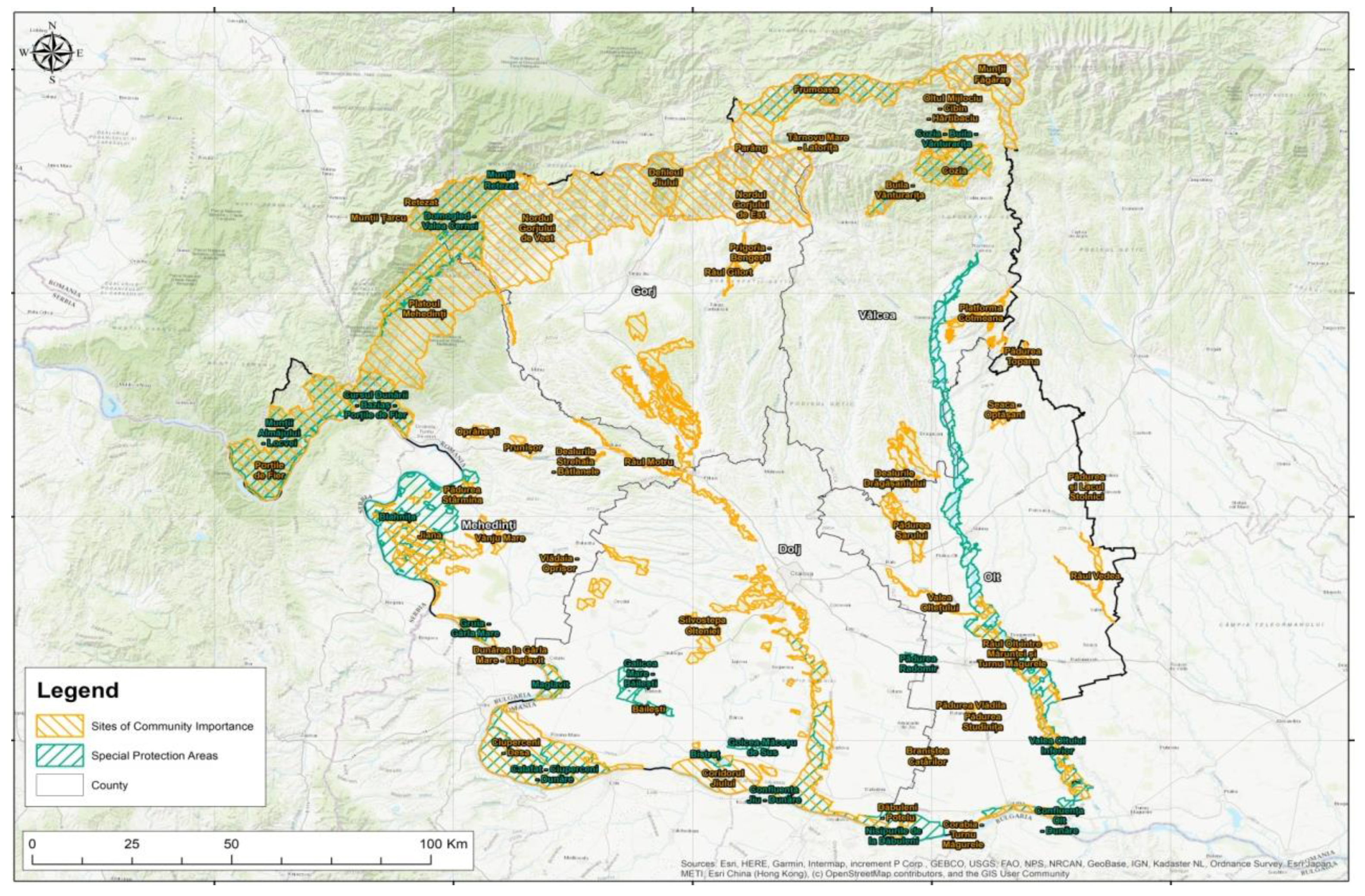
Chorematic Analysis of the South-West Oltenia Region

The South-West Oltenia region (Figure 3) includes Dolj, Olt, Vâlcea, Gorj and Mehedinți counties, which were the basis of the political and administrative entity of Romania [70].
The current choremic analysis aims to highlight the spatial organization of the area, the delimitation of areas with high tourist potential, and the relationships/flows between them in the South-West Oltenia region.
The territory of the South-West Oltenia region has as its main polarizing centre the city of Craiova, which is the only city of the first rank in the region. The city is an important university centre, being the only one in the region with an airport, and from a tourist perspective it is host to numerous high-ranking landmarks and institutions (museums, opera, theatre, hospitals, courthouses, tribunals, etc.).
From a choremic perspective, due to the orographic conditions (barriers), we can delimit the South-West Oltenia region into two distinct areas, Southern Oltenia (the plain area) and Northern Oltenia (mountainous and hilly area).
In the case of Northern Oltenia, the morphological factor influences the functional axes and the spatial configuration. In this area, we can delineate three regional polarizing centres, of rank II: Drobeta Turnu Severin, Târgu Jiu and Râmnicu Vâlcea (Figure 4).
The two proposals for new tourist destinations are located in Northern Oltenia (Figure 3), the first being the ecotourism-sustainable destination Clisura Dunării, which is located in Caraș-Severin county: Coronini, Gîrnic, Sichevița, Berzasca and Șopotu-Nou, and in Mehedinți county: Svinita, Dubova, and Eşelnita. The second proposal is the UNESCO Geopark Oltenia de sub Munte formed of six administrative units: Vaideeni, Horezu, Costești, Bărătești, Stoenești and Băile Olănești. The two proposals for new tourist destinations represent a strong point for practicing ecological tourism, the communes located within the destinations can represent new rural spaces for the economic development of tourism.
The municipality of Târgu Jiu represents an important regional central place and at the same time the Brâncuși heritage in the city can be very well capitalized in tourism [71].
In the case of the municipality of Drobeta Turnu Severin, it is starting to establish itself as a real pole, despite its peripheral position; the municipality managed to overcome the status of a peripheral city thanks to the presence of the navigable axis of the Danube and the national road E70, at the same time, the interrelations with Serbia and the vicinity of the city of Orșova helped the municipality to reconfigure the axes, respectively, the flows of information and materials [72].
From a tourist point of view, here we can find historical vestiges, such as the bridge of Apollodorus of Damascus and the Roman fort.
The presence of the Râmnicu Vâlcea municipality led to the development of some secondary functional axes and favoured the development of an intensely peri-urbanized area [71].
Other tourist areas of local importance are Muierilor Cave, Polovragi (with the cave and monastery of the same name) and Tismana. The area has potential in the field of speotourism due to the multitude of caves, primarily in the Mehedinți Mountains and Plateau. A spectacular mountain landscape, with the possibility of skiing, is represented by the Parâng, Făgăraș, Latoriței and Cozia Mountains. Additionally in this area, we find waterfalls, springs and mineral waters with therapeutic qualities, and cultural tourism is represented by the religious landmarks of the region [72].
The areas of international tourist importance are found along the Jiu Valley towards the Danube Gorge.
The mountainous area generates centrifugal flows and lacks territorial nuclei for development; rural settlements in the mountain area, from the perspective of territorial and tourism development, are fragile because the subsistence economy and the lack of attractiveness of tourist areas led to the inability to effectively control the factors of development [71].
The main axis of the area has a north-south orientation and is generated by the existence of regional and local polarizing centres (Târgu Jiu, Rovinari, Bumbești Jiu, Plopșoru), and by the existence of a corridor of national importance (it connects the southern part of the country with the Pan-European corridor IV); the secondary axes developed due to the presence of some urban centres of local importance (Baia de Aramă-Tismana-Târgu Jiu, Novaci-Târgu Cărbunești-Târgi Jiu) and the functional axes appeared due to the lack of supra-communal polarizing centres (Baia de Aramă—Drobeta Turnu Severin, Baia de Aramă-Motru, Novaci-Râmnicu Vâlcea) [71].
The choremas for Northern and Southern Oltenia (Figure 4 and Figure 5) were created as follows: we used the Open Street Map (OSM) [73] (open source) as a database in order to extract the tourist landmarks. The limits of the protected natural areas were downloaded from the website of the Ministry of Environment, Water and Forests [74]. In the graphic modelling, for the theoretical elements (without spatial dimension) we used the simplified (qualitative) symbolic representations to suggest the existing spatial connections and flows in the analysed geographical space. The relationships and connections mentioned were inferred from the references mentioned below.
The representation of information and material flows of cities, respectively, of functional axes was carried out with the following qualitative cartographic methods: (1) pseudo-area method: the limits of flows and functional axes are not precisely determined and delimited, (they have a symbolic spread), therefore, the hatched area is used as a symbol; (2) the method of movement lines: territorial relations represent a phenomenon that moves along some lines, thus we used as a symbol, for their route, strips containing geometric shapes; this method suggests the dynamics of the analysed phenomenon; and (3) the method of signs: used to represent the type, size and importance (rank) of cities (the larger the circle, the more important the city).
The data and information about the South-West Oltenia region mentioned above were extracted from the following sources: County Territory Development Plans of Dolj [75], Gorj [76], Mehedinți [77], Olt [78], Vâlcea [79,80].
The areas of influence of the county seats were calculated with the Reilly-Converse gravity model and are represented by the cartographic quantitative method. This gravity model assumes that a city’s influence decreases with distance and increases with city size (population). Thus, in order to generate the area of influence of each county seat in Oltenia (Craiova, Slatina, Drobeta-Turnu Severin, Târgu Jiu and Râmnicu Vâlcea) in GIS, we followed the specific steps (based on Rusu, 2004 and adapted for the Geographic Information System): 1. there were joined (by drawing some lines) the analysed city (point) with all the surrounding cities (points), using the Euclidean Distance tool; 2. using Reilly-Converse’s formula, there were calculated for the drawn lines, the “border” points, which were marked with dots (Split Line at Distance Tool); 3. from the “border” points we drew perpendicular lines, so that they are perpendicular to the initial lines from step 1 (Straight Segment Tool—Constrain Perpendicular); and 4. the lines drawn in step 3 intersect and form a polygon, which represents the area of influence of the analysed city.
In the case of Southern Oltenia, we can delimit two polarizing centres, the municipality of Craiova, a real central place, and the municipality of Slatina, a regional polarizing centre of rank II (Figure 5).
Southern Oltenia is characterized by a relatively homogeneous natural setting (mainly plains), thus, the force fields do not suffer disjunctions, and the area is characterized by centripetal flows, both towards the poles and towards the polarizing centre Craiova [71].
The functional axes present a convergent geometry towards the main polarizing centre; the geometry of the main axis (E70, E79, E574) betrays the interdependence with the neighbouring regional systems (Potcoava-Slatina-Balș-Craiova-Filiași-Turceni, Filiași-Strehaia) [71].
The secondary axes were generated due to the relations between the main polarizing centre and urban centres of local and supra-municipal importance (Craiova-Bălăcița-Vânju Mare-Devesel, Craiova-Caracal-Drăgănești Olt-Radomirești); secondary axes also appeared between the main polarizing centre and the port cities on the Danube due to coordination and subordination relations (Craiova-Segarcea-Băilești-Calafat, Craiova-Sadova-Bechet, Craiova-Caracal-Corabia); the secondary axis of Olt (Drăgășani-Slatina-Drăgănești Olt-Rusănești-Islaz-Turnu Măgurele) interconnects the urban centres, but cannot integrate the rural localities on the right and left of the Olt river due to the lack of bridges. An anisotropic Danube axis appears that is marked by the presence of ports [43].
In this area, tourist activities are much less developed than in Northern Oltenia and cultural tourism is practiced in the areas of the Danube Gorge, the Iron Gates, Cerna Valley, Bucharest [72]. The most important accommodation capacity is in Craiova [71].
The highlighting of the natural (the presence of the Danube in the south of the region with its spectacular gorge and specific landforms, and also with the Iron Gates natural park; in the north of the region there are mountain resorts, Rânca and Straja, popular for winter sports and hiking activities) and anthropogenic elements of the South-West Oltenia region is achieved through choremes, through graphic and cartographic modelling, which according to Ianoș [81], they express actions, projects, and results, representing the “signature” of societies on the space.
The promotion of tourist areas and their integration into county, national and international circuits represent sustainable development measures to increase the prestige of the South-West Oltenia region (Table 1).

5. Discussion

5.1. Capitalization of the Tourist Resources of Oltenia

In environmental terms, the exploitation of tourism resources should have sufficient attractiveness to attract potential tourists [82]. In this way, introducing taxes, fees for entering protected areas, parking fees, tourist guide services, etc., exactly at the same time, stimulate the management of resources and the financing of environmental conservation. In social terms, many people who travel to natural areas do so specifically to indulge in experiences with nature [82]. Protected area managers are responsible for fortifying the quality of available natural experiences and working to foster ‘transformative values’ which, through a learning experience with nature [83], generate greater awareness, value and an appreciation of the environment and the ecosystems in the natural environment of the protected areas.
The hypsometry of landforms in the region varies from 2456 m to 17 m, the region having meadow, plain, hill, plateau, Subcarpathians and Carpathians.
The hydrography of the South-West Oltenia region is varied (Figure 6); it is crossed by numerous rivers and their tributaries, the most important being Jiu, Olt, Motru, Cerna and Lotru.
In areas where water resources are rich in quantity and quality, they can be used for spa and wellness purposes, even turning water into a tourist product in itself [84], as it is the case of Vâlcea county, which has several spa resorts (Băile Govora, Băile Olănești, Călimănești-Căciulata, Ocnele Mari). Recreational activities in tourism need water, such as water sports, fishing [85], water tours [86] and health tourism [84].
Spa and wellness tourism are two well-developed forms of tourism in Romania; spa tourism represents one of the oldest forms of tourism in the country, having a very high impact on economic development [87]. Water is a limited and vulnerable natural resource; it must be protected by law. In Romania, the use and exploitation of water resources are regulated by Water Law No. 107/1996 [84].
In the context of the economic crisis caused by COVID-19, traditional spas have the necessary infrastructure [88] both in terms of human resources and from a technical point of view; medical spas could support persons who have gone through COVID-19 for recovery treatment to improve their health [89]. At the same time, the general positive image of the citizens regarding spas who have shown their interest in this type of treatment represents another advantage of using medical spas in the treatment of patients with post-COVID-19 symptoms [90]. Therefore, spa therapies could be easily accepted and trusted by COVID-19 patients who need recovery after traditional hospital treatment [60,91].
In specialized literature, the best-known form of nature conservation is represented by national parks [92], which are represented by unprecedented and spectacular landscapes, the inestimable value of tourist attractions, and at the same time, elements that bring symmetry to tourism (relief, climate, hydrography, vegetation, etc.). Some researchers argue that this form of nature conservation should be treated as an investment for future generations [93], reducing the anthropogenic impact that occurs in natural areas.
According to the definition given by the International Union for Conservation of Nature, the concept of “national park” refers to an area for the protection of ecological processes on a national and international scale [94]. Thus, based on the IUCN definition, the main objective of a national park is the protection of biodiversity, simultaneously promoting, firstly, education and secondly, recreation [95].
Protected areas, such as natural parks, present many distinct characteristics such as protection, conservation of cultural diversity, and conservation of biological diversity of different species and wildlife [96,97]. They are also a resource for slowing the decline or preventing the extinction of different types of endangered species, helping to maintain their natural habitat [98].
Natural parks represent protected natural areas whose goals are landscape protection and conservation, corresponding to category V of the International Union for Conservation of Nature.
Recently, several studies have analysed the experiential context of natural parks [99,100] considering these nature-based destinations as spatially and culturally bounded. Thus, within a natural park, tourists can experience a specific place [101], the experience is characterized by uniqueness, multidimensionality, and originality for each situation and visitor [102].
Currently, the Oltenia region brings together three national parks and two natural parks (Figure 7): Cozia National Park, Buila-Vânturarița National Park, Jiu Gorge National Park, Domogled-Valea Cernei National Park, Mehedinți Plateau Geopark and Iron Gates Natural Park.
Numerous avifaunistic special protection areas (SPAs) and sites of community importance are located in Oltenia, on the territory of the five counties (Figure 8) [103].
The location of Vâlcea County is clearly defined by the geographical coordinates. It is located between 48°28′ and 48°36′ parallels north latitude and between 23°37′ and 24°30′ meridians east longitude [104]; the northern boundary is westwards from the source of the Scara stream (a tributary of the Topolog river), located below the ridge of the Scara peak (2285 m), the western part of the northern ridge of the Făgăraș mountains, then followed by the peaks of Suru (2285 m), Tătaru (1890 m) and Chica Fedeleșului (1819 m) and descending in a south-western direction into the Olt gorge, in the north of the Râu Vadului village [104,105].
For the analysis of the net utilization index of the tourist accommodation capacity in operation, we took into account the year 2018 before the start of the epidemiological outbreak caused by the SARS-CoV-2 virus and the year 2021 during the pandemic period. The investigation, determination and statistical interpretation of the index were carried out for 20 communes within Vâlcea county. Thus, analysing Figure 9, it can be noticed that more than half of the communes recorded a downward trend during the pandemic, except for six communes where increases were recorded during the period of COVID-19: Golești—9.51%, Lungești—7.60%, Malaia—12.31%, Maldărești—60.02%, Mihăești—8.88% and Slătioara—7.82%. These increases in 2021 are due to the increase in the number of overnight stays in accommodation units in Golești, Lungești, and Mihăești. Malaia, Măldărești, and Slătioara recorded increases in 2021 for both research variables, i.e., tourists’ overnight stays, but also the tourist accommodation capacity in operation.
The improvement of the national economy, the personality of the Romanian culture and the diversity of the abundant tourism resources have all played a role in the rapid growth and development of domestic tourism in Oltenia [106]. The main trends that influence the development of tourism are: tourist products of inter-regional tourism; climatic changes during the year (air temperature—°C and precipitation—mm); but also governamental political changes [107]. Therefore, tourism can be a vector of social and economic development after a period of conflict [108], a period of economic crisis that affects the economic sectors especially tourism, or after a pandemic produced by the epidemiological virus COVID-19 (starting with the 2020 period—the onset of the pandemic until the 2021–March 2022 period of the spread and evolution of the mutations of this virus).

5.2. Analysis of Forms of Tourism in Oltenia

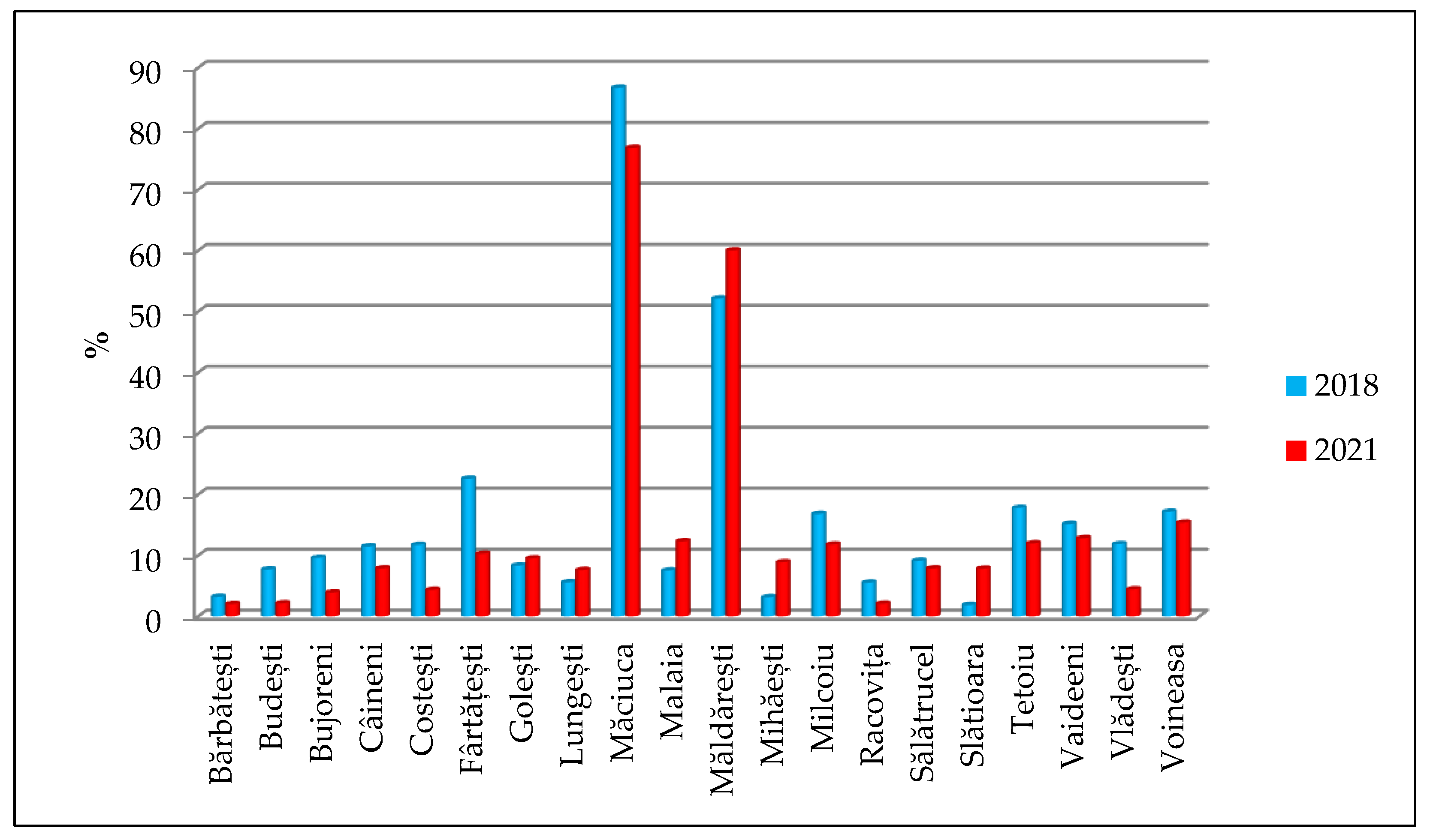
5.2.1. Rural Tourism

Rural tourism, or farm tourism, can represent a new source of income for the population of rural villages in Oltenia in the 21st century.
Rural tourism in Romania has been practiced since ancient times, but in an unexpected, random, accidental and above all unorganized manner. It began in the 1920s–1930s as accommodation for occasional visitors in rural settlements. After 1989, it began to respond to the economic, social, cultural and spiritual needs of tourists [108].
The main traditional products and resources that can be exploited through this form of tourism: traditional architecture, traditional objects, folk clothing, folk sculpture, traditional folk instruments, folklore events, various traditional and ecological gastronomic products; in other words, the specific rural way of life, with multiple benefits for all tourists who participate in this activity [109].
The development of tourism in the rural area of Oltenia could have numerous effects with a direct impact on rural villages [110,111]:
  • Improving the general infrastructure on which the economic revitalization of the rural village depends (road transport, rail transport, local roads, water network, sewage, telecommunications, electricity, and thermal energy);
  • Forming farms, guesthouses, and tourist households, as well as organizing activities, but respecting local traditions and architecture, avoiding kitsch;
  • The identification, inventory and exploitation of natural tourist resources; the development and modernization of those placed in the tourist circuit with special emphasis on entertainment, animation, and recreation;
  • Drawing up a register of the main events in the life of the village (cultural, religious, traditions, exhibitions, fairs, etc.), memorials, craftsmen, and local rhapsodies, to present authentic tourist programs of rural-traditional village;
  • The promotion of rural villages with natural and anthropogenic tourism potential, within international festivals, symposiums, and conferences with specific tourism, tourism fairs, and congresses;
  • The practice of other forms of tourism, in correlation with rural tourism (tourism in nature—ecotourism, agritourism, speleological tourism, mountain tourism and water sports;
  • The creation of new tourist routes, within the national and natural parks of Oltenia, with a negative impact on the environment;
  • The construction of tourism-specific households called “ecological smart city”; the manager of such a household has the attribution to collaborate with the managers of tourist and agritourism guesthouses, with local councils, and with the administrators of protected areas for the ecological exploitation of existing resources within a rural village.
The tourist potential of the Oltenia tourist destination is currently exploited only to a small extent. From the point of view of tourist activities, the number of accommodation units, according to NIS (National Institute of Statistics) 2021, is presented in Figure 10.
Referring strictly to the rural tourism activity, the accommodation units (tourist and agritourism guesthouses) in the Oltenia area according to the statistics from the five counties, approximately 399 accommodation units, in 2021, variably distributed on the territory of the region Table 2.
The existing tourist accommodation capacity in Oltenia analysed for the year 2021 (Figure 11) shows that tourist guesthouses have recorded the highest values in terms of the number of tourist accommodation bed places (1569 tourist guesthouse accommodation bed places in Vâlcea county), and at the opposite pole it is the county of Olt with only 45 bed places to stay in agritourism guesthouses.
Analysing the statistical data available from the National Institute of Statistics of Romania regarding the number of accommodation bed places that tourists can benefit from, taking into account the number of days, considerable differences are noted between the five counties of the region (Figure 12). Thus, in 2021, the tourist accommodation capacity in operation has increased in the counties of Dolj, Olt and Vâlcea for tourist guesthouses, and in Gorj and Mehedinți for agritourism guesthouses.

5.2.2. Glamping

The new form of post-pandemic COVID-19 tourism represents a new trend in tourism development right from the 2020–2021 period of the pandemic caused by the SARS-CoV-2 epidemiological virus; this presents itself as a current emerging trend, which is becoming day by day the most loved form of tourism by international tourists. The main reasons for the increased pandemic threat in the 21st century are [8]: a rapidly growing and mobile world population; urbanization trends and the concentration of people; industrialized food production in global value chains; increased consumption of higher-order foods, including products of animal origin; and the development of global transport networks that act as vectors in the spread of pathogens [113,114].
Glamping is a recent and still unexploited concept that derives from tourism in nature, between this concept and that of sustainable tourism there is a relationship of efficiency as a means for the correct development of a tourist destination [115], such as the Oltenia region.
Glamping in the specialized literature is found to be an increasingly popular and accessible modern form of camping [116] that preserves an outdoor leisure experience [117] in mountain areas offering the same time facilities and accommodation, but also leisure activities.
Glamping can represent a new form of regional-sustainable development for the Oltenia region; so far there is only one county (Vâlcea) that has developed this new form of tourism, accommodation is in a tent in the middle of nature and spectacular landscapes (Brâncoveanu Glamping is located in Văratici, 23 km from Călimănești; Epic Glamping, located in Călimăneşti and Căsuțe, 23 km from Băile Govora—Figure 13).

5.3. Ecotourism

Ecotourism is identified in the literature as a form of sustainable tourism that is expected to contribute to both conservation and development [82] positively for hotel managers and residents who live within the protected areas.
The World Conservation Union (IUCN) Commission on National Parks and Protected Areas (IUCN) has defined the term ecotourism as “the ecologically responsible travel and visit relatively undisturbed natural areas to enjoy and appreciate nature (and any accompanying cultural features, both past, and present) that promote conservation, have a low negative impact on visitors and ensure the active beneficial socio-economic involvement of local populations” [82,118].
The tourist resources, the communities of the rural area, and the tourists who visit the area of Northern and Southern Oltenia have important roles in the development of the county and regional tourism. Analysing theoretically a post-pandemic COVID-19 paradigm for the development of effective ecotourism is decisive for the evolution of these three stakeholders, so that each makes positive contributions to the others, constantly.
Likewise, many scholars in the field have noted that changes in economic, social, and environmental dimensions are the main factors influencing sustainability and that these three dimensions influence each other [119,120,121].
Ecotourism has a wide range of benefits for the local community [122]. According to the definition of the World Tourism Organization, it presents the following characteristics: it lends itself to small groups of tourists; it involves small and local businesses in the exploitation of natural resources; it has an important educational aspect; high emphasis on reducing the negative impact on the environment and local communities; and not lastly, it supports the socio-economic development of the natural areas in Oltenia [123,124,125].
Romanian ecotourism is an attractive but also sensitive field, which needs well-made national legislation [125] that protects with the minimal impact the tourist resources that exist in every administrative-territorial unit in Romania. The Romanian tourist potential and the progress recorded in the field in recent decades highlight the need for greater involvement of the authorities in this regard [125]. Additionally, there is a need for: a collaboration between state institutions and residents, in the form of partnerships for the development of new tourist areas; for the balanced exploitation of tourist resources; the development of leisure, entertainment and animation areas; the creation of tourist information centres where they do not exist; and the inventory of fauna and flora within protected areas. For Oltenia, there is Vâlcea County, which presents from our point of view the most complex framework for ecotourism development (Figure 14) through the two national parks: Cozia National Park with 17,100 hectares and Buila-Vânturarița National Park with an area of 4186 hectares, being the smallest national park in Romania.
The Oltenia region is not limited from the point of view of practicing only the three forms of tourism presented, but there is a varied range with multiple valences of practicing regional-sustainable tourism (Figure 15), mountain tourism—white tourism (skiing—Perișani Ski Slope and Transalpina Ski Resort), speleological tourism and ecological tourism within the protected area of national interest –Piciorul Boului (speleological nature reserve) located in Câineni commune.

5.4. Regional-Tourist Identity Brand and Slogan

The branding of a location is first a vital field of research, and secondly, it represents a very important tool for the strategic development of the positioning of tourist destinations in the territory [126] and was named by different terms, “national branding”, “place branding”, “destination branding” [127], and we could add new “local branding”, “county branding” and “regional branding”.
The destination brand was defined by [128,129] as “a name, a symbol, a logo, a keyword or any graphic sign that identifies and at the same time differentiates the destination; moreover, it expresses the promise of a memorable travel experience that is uniquely associated with the destination; [the brand] serves to strengthen the emotional connection between the visitor and the destination”.
The branding of the Oltenia tourist destination is a very complex issue that must reconcile the identity of the tourist space, the projected image of the area, the offer of tourist products, the consumer experience, and the perceived image of visitors [130].
Thus, it is appropriate to create a tourist brand (Figure 16) of the South-West Oltenia region. Oltenia must be represented by a symbol, which highlights the sum of all the perceptions and associations that the inhabitants have concerning the region in which they live, but on the other hand, have a pleasant visual aspect and a meaning that will not be forgotten by tourists who visited the region.
The promotion of the Oltenia brand must take into account three essential assets for the development of regional-sustainable tourism: the most attractive presentation of the opportunities to practice forms of tourism, visiting the landmarks and the creation of new adaptive tourism products after the COVID-19 pandemic in the Oltenia region.
Brand symbol elements are widely used in tourism marketing. The logo, one of the key elements of the brand symbol, is often considered central to tourism destination branding and marketing communication [127].
The slogan proposed for the complex development and capitalization of Oltenia heritage that we own is one of the most innovative in the tourism sector.
Consequently, we propose “Oltenia the realm of ecotourism” representing a regional-innovative-sustainable slogan. It is supported at the same time by the creation and existence of an original brand, a positive tourist reflection on the natural environment, and last but not least, a truthfulness that supports the information transmitted to current and future tourists of this region in Romania.
The sustainable development of a region in terms of tourism should be based on a certain guideline with direct impact on the sector and on local population. These include: the improvement of cooperation with local communities (engaging them in the process to ensure that their values are included in destination development plans); the facilitation of connecting rural to urban livelihoods; the environmental wellbeing and the social outcomes of development; the faster digitalization of the travel sector and the new traveller profile created after the COVID-19 pandemic who, wary of crowds, are seeking new areas for vacations; and rural and smaller destinations, are all growing in popularity. These all represent starting points to create a system that needs to support the future of travel, to help local communities and to ensure safe travelling.

6. Conclusions

This study presented a new vision on the connections between the Geographic Information System and the elements that bring added value to the tourism heritage, both natural tourism resources and forms of ecological tourism (ecotourism, glamping and rural tourism), underlining them in the applied chorematic method for tourism.
The Geographical Information System creates new opportunities for researchers to develop, concretize, expand and produce new touristic methods of statistical data processing and interpretation, available online, and supplemented with topographical data from the field.
This study complements the existing literature by accentuating the link that can be created between spatial modelling methods and tourism planning and development at different scales within a country: local, regional or national level. The model can also be extended for macro-scale regions. The choreme method also serves as a tool for better understanding and evaluating the space from a touristic point of view, adding up to the flows and areas of influences that are created at the regional level, as invisible links for proper development and capitalization of resources.
Since “Choremes are elementary structures of space, abstract by definition” [63], it can be concluded that their representation is a compilation that the researcher elaborates to interpret the geographical reality in the territory.
Within the Oltenia tourist destination, the arrangement, organization and development of the tourist space with the help of the choremes method is based on seven symbols (Figure 3 and Figure 4):
  • Area—represents the geographical space of the Oltenia region, which is analysed in the form of a square, polygon, or triangle;
  • Point—represents coordination and subordination relations with regional centres;
  • the line—represents the boundary separating the geographical space in North Oltenia and South Oltenia;
  • The flow—marks an asymmetry and a determining direction of action in the territory, that are the four functional axes of the region: main axes, secondary axes, junctional axes, and the anisotropic axis;
  • The passageway—connects two open spaces, i.e., the infrastructure—roads;
  • Circle—indicates the main categories of localities;
  • The rhombus—represents the protected areas in Oltenia.
Thus, from those listed previously, the symbols that can be used to cartographically express tourist choremas for any geographical space are formed of three essential geometric figures: the point, the line and the surface of the region.
The combination of these symbols can produce a great diversity of meanings and laws forming a real tourism alphabet that helps to elucidate many geospatial relationships, thus allowing the analysis and general interpretation of the spaces for carrying out tourist activities in the South-West Oltenia Development Region.
If we include the touristic choremas made for Oltenia in the virtual environment, we can improve the prospects of tourism development (on the five counties of the region), both for tourism managers and for local communities.
To study the graphic and cartographic modelling of the South-West Oltenia regional space, and to successfully include the analyses previously carried out by other researchers, we consider that a representation of the territory with the help of the chorema method is preferable because much of the information presented is difficult to structure on paper.
At the base of the arrangement, organization and development of the geographical space related to the South-West Oltenia Development Region is the geological substrate and the morphological, hydrological and climatological ones. Together, the four invariable systems are the foundation upon which all other mobile systems are based on. The importance of the geological structure, the morphology, the hydrological network and the climatic indicators in the structuring, organization and development of the region is maximum, these systems predestining the socio-economic development of the space by creating ideal habitat spaces in urban and rural areas.
The cooperation of morphological and hydrological factors led to the development of a varied space (with specific forms of relief—meadow, plain, hill, plateau, Subcarpathians and mountains), but predestined for the transit of the human population, the hydrographic network sculpting two major hydrographic basins (Jiu and Olt).
The overlapping of communication road networks and settlement systems over the natural system formed by the geological, morphological structure, hydrographic network and climatic indices gave rise to a heterogeneous, flexible and variable system that had to adapt to the rigor imposed by the natural and anthropic framework of the traditional region “Oltenia”.
The free spaces between the poles of urban development, called by G. Gusti (1974) “eyes of the cardinal network” represent an ecological space where natural systems (forests) or agro-natural ones (arable land, pastures, hayfields, vineyards, orchards) predominate, their main role being that of production and balance for economical and tourism developed areas. The existence of ecological zones at the level of the development region represents an important factor for the balance of the space, in addition to the strict role of production they can also provide consumer services.
Various studies [131,132,133,134,135,136,137,138,139] have shown that tourism, combined with rural or local resources and traditional/rural specific products, would be an important “tool” for the revitalization of the rural economy and the sustainability of [108] counties in the Oltenia region and that this should be a primary component of the strategy for the development of the tourism economy in the Oltenia countryside.
Additionally, beside rural tourism, the role of educational tourism has a great impact in broader urban and regional areas on different age groups. New market segments of tourist can be explored and better capitalized. There are papers that tried to understand the characteristics of the new generation of senior consumers for the tourism industry [140], this segment of the market being relevant to tourism for the high purchasing power and leisure-oriented lifestyle. Senior tourism is started to be linked with the quality of life [141]. Although in the past retired tourists were considered just another type of tourist, currently they are a growing segment with income that could travel out of the seasons. From another group age perspective- the youth, ref. [142] considers young people not only beneficiaries of tourism sector as travellers, but also an important workforce that can contribute to the restart of tourism after the pandemic, regardless their background or studies. Other studies [143,144] present the impact that a visit to a memorial museum can have as an educational experience for young travellers that want to understand and remember the communist past, a period of human rights abuses.
Thus, tourism, as a branch of great socio-economic perspective, enjoys a coherent and efficient analysis, highlighting the natural and human tourism potential, the tourism infrastructure, the forms of tourism, and the regional-sustainable framework of the main functional entities, with innovation perspectives for Oltenia tourism.
The natural tourist potential formed of landforms, hydrography, climate, vegetation, fauna, flora and protected areas is sometimes surpassed by the uniqueness, originality and diversity of the anthropogenic tourist potential (museums, churches, monasteries, caves, avenues, quays, memorial houses, etc.).
This research paper brought to the fore the reflections from specialized literature regarding the capitalization of tourist resources in correlation with their analysis in Oltenia geographical space, through the forms of ecological tourism that can be practiced in the study area. At the same time, it presents the tourist choremes and the proposal of a logo with a slogan in order to increase the visits in the Oltenia region and the two proposals for new tourist destinations (the ecotourism-sustainable destination Danube Gorge and the Oltenia de sub Munte Geopark). Considering the arguments presented regarding the originality of the research methodology, several limitations can be identified.
Firstly, the method was applied on a specific study area (South-West Oltenia Development Region), but it can be further developed in order to analyse different touristic spaces (cities, counties or resort). Additionally, there are no researches using the chorematic method on large areas such as the Oltenia region, the obvious advantages being the larger analysis of tourist resources in correlation with the territory, thus increasing the development of policies and strategies at macro-level. The tourists visiting the studied region can associate the ecological tourism with different cultural landmarks and historic aspects such as stories, legends etc.
Continuing the studies [68] that evaluated the tourist potential of rural areas, focusing on the residents’ and non-residents’ perception on the rural tourism form, future research directions could involve applying more the GIS techniques in tourism studies at regional or local level using different tourism indices to determine the attractiveness of different parts of the region or of different landmarks, leading to new policies for regional tourism development, and also to certain changes of perception when choosing the studied region as a tourist destination.
In conclusion, the role of the region in the national system must be consistent with its social, economic and development needs at the local, county, regional and national levels.

Author Contributions

Conceptualization, A.N., I.-A.D. and M.M.; methodology, I.-A.D. and A.N.; Software, I.-A.D. and A.N.; validation, A.N. and M.M.; formal analysis, I.-A.D., A.N. and M.M.; investigation, M.M., I.-A.D. and A.N.; resources, I.-A.D. and A.N.; data curation, A.N. and I.-A.D.; writing–original draft preparation, I.-A.D. and A.N.; writing–review and editing, A.N. and M.M.; visualization, I.-A.D. and A.N.; supervision, M.M.; project administration, I.-A.D. and A.N. All authors have read and agreed to the published version of the manuscript.

Funding

This paper was supported by the research fund of the University of Craiova, Romania.

Institutional Review Board Statement

Not applicable.

Informed Consent Statement

Not applicable.

Data Availability Statement

Not applicable.

Conflicts of Interest

The authors declare no conflict of interest. The funders had no role in the design of the study; in the collection, analysis, or interpretation of data; in the writing of the manuscript, or the decision.

Abbreviations

The following abbreviations were used in this paper:
GISGeographic Information System (Software)
QGISapplication for geographic information systems (GIS)
NISNational Institute of Statistics
NuiNet utilization index of accommodation capacity in operation
OsOvernights registered in a certain period
TacioTourist accommodation capacity in operation
CTDPCounty Territory Development Plan (Dolj, Gorj, Mehedinți, Olt and Vâlcea)
UNESCOUnited Nations Educational, Scientific and Cultural Organization
IUCNInternational Union for Conservation of Nature
SPAArea of special avifaunistic protection
COVID-19infectious disease caused by the coronavirus (the latest virus of the 21st century)

References

  1. UNWTO. Tourism towards 2030 Global Overview; UNWTO: Madrid, Spain, 2011; Available online: https://www.unwto.org/archive/global/press-release/2011-10-11/international-tourists-hit-18-billion-2030 (accessed on 16 September 2022).
  2. Gössling, S.; Hansson, C.B.; Hörstmeier, O.; Saggel, S. Ecological footprint annalysis as a tool to assess tourism sustainability. Ecol. Econ. 2002, 43, 199–211. [Google Scholar] [CrossRef]
  3. Katircioğlu, S.T. Testing the tourism-induced EKC hypothesis: The case of Singapore. Econ. Model. 2014, 41, 383–391. [Google Scholar] [CrossRef]
  4. Dogan, E.; Aslan, A. Exploring the relationship among CO2 emissions, real GDP, energy consumption and tourism in the EU and candidate countries: Evidence from panel models robust to heterogeneity and cross-sectional dependence. Renew. Sustain. Energy Rev. 2017, 77, 239–245. [Google Scholar] [CrossRef]
  5. Katircioglu, S.; Cizreliogullari, M.N.; Katircioglu, S. Estimating the role of climate changes on international tourist flows: Evidence from Mediterranean Island States. Environ. Sci. Pollut. Res. 2019, 26, 14393–14399. [Google Scholar] [CrossRef]
  6. Robaina-Alves, M.; Moutinho, V.; Costa, R. Change in energy-related CO2 (carbon dioxide) emissions in Portuguese tourism: A decomposition annalysis from 2000 to 2008. J. Clean. Prod. 2016, 111, 520–528. [Google Scholar] [CrossRef]
  7. Dolnicar, S.; Zare, S. COVID-19 and Airbnb—Disrupting the Disruptor. Ann. Tour. Res. 2020, 83, 102961. [Google Scholar] [CrossRef]
  8. Gössling, S.; Scott, D.; Hall, C.M. Pandemics, tourism and global change: A rapid assessment of COVID-19. J. Sustain. Tour. 2021, 29, 1–20. [Google Scholar] [CrossRef]
  9. Rice, W.L.; Mateer, T.; Taff, B.D.; Lawhon, B.; Reigner, N.; Newman, P. The COVID-19 pandemic continues to change the way people recreate outdoors: A second preliminary report on a national survey of outdoor enthusiasts amid the COVID-19 pandemic. SocArXiv 2020. [Google Scholar] [CrossRef]
  10. Zotic, V.; Puiu, V. The role of the integrated network concept in elaborating the territorial development choremes. Case study: The peri-urban zone of the Municipium of Bistrița. Rom. Rev. Reg. Stud. 2006, 2, 65–76. [Google Scholar]
  11. Marchand, J.; Gaudin, S. Chorèmes et systèmes. Retours sur deux approches complémentaires de modélisations graphiques en analyse spatiale et leurs devenirs. L’Information Géographique 2022, 86, 72–99. [Google Scholar] [CrossRef]
  12. Reimer, A.W. Understanding Chorematic Diagrams: Towards a Taxonomy. Cartogr. J. 2010, 47, 330–350. [Google Scholar] [CrossRef]
  13. Bahaire, T.; Elliott-White, M. The Application of Geographical Information Systems (GIS) in Sustainable Tourism Planning: A Review. J. Sustain. Tour. 1999, 7, 159–174. [Google Scholar] [CrossRef]
  14. Achamyeleh, Z.; Makonnen, T. GIS and Remote Sensing Based Site Suitablity Analyisis for Tourism Development in East Gojjam Zone, Ethiopia. J. Remote Sens. GIS 2022, 11, 1000252. [Google Scholar] [CrossRef]
  15. Albuquerque, H.; Costa, C.; Martins, F. The use of Geographical Information Systems for Tourism Marketing purposes in Aveiro region (Portugal). Tour. Manag. Perspect. 2018, 26, 172–178. [Google Scholar] [CrossRef] [Green Version]
  16. Mäntymaa, E.; Tyrväinen, L.; Juutinen, A.; Kurttila, M. Importance of forest landscape quality for companies operating in nature tourism areas. Land Use Policy 2021, 107, 104095. [Google Scholar] [CrossRef]
  17. Rahayuningsih, T.; Muntasib, E.K.S.H.; Prasetyo, L.B. Nature Based Tourism Resources Assessment Using Geographic Information System (GIS): Case Study in Bogor. Procedia Environ. Sci. 2016, 33, 365–375. [Google Scholar] [CrossRef] [Green Version]
  18. Ristić, D.; Vukoičić, D.; Milinčić, M. Tourism and sustainable development of rural settlements in protected areas—Example NP Kopaonik (Serbia). Land Use Policy 2019, 89, 104231. [Google Scholar] [CrossRef]
  19. Vukoičić, D.; Ristić, D.; Milinčić, U.; Petrović, D.; Mihajlović, L.; Božović, S.; Protić, B. Assessment of the Attractiveness of Natural Resources and Landscapes of the Kopaonik National Park (Serbia): Framework and Importance for Tourism Development. Pol. J. Environ. Stud. 2023, 32, 281–295. [Google Scholar] [CrossRef]
  20. Valjarević, A.; Vukoičić, D.; Valjarević, D. Evaluation of the tourist potential and natural attractivity of the Lukovska Spa. Tour. Manag. Perspect. 2017, 22, 7–16. [Google Scholar] [CrossRef]
  21. Craig, C.A. Camping, glamping, and coronavirus in the United States. Ann. Tour. Res. 2021, 89, 103071. [Google Scholar] [CrossRef]
  22. Ellerbrock, M.J.; Hite, J.C. Factors Affecting Regional Employment in Tourism in the United States. J. Travel Res. 1980, 18, 26–32. [Google Scholar] [CrossRef]
  23. Radisic, B.B.; Basan, L. The logistics of selling a destination’s tourism product. Tour. Hosp. Manag. 2007, 13, 725–732. [Google Scholar] [CrossRef]
  24. Rosentraub, M.S.; Joo, M. Tourism and economic development: Which investments produce gains for regions? Tour. Manag. 2009, 30, 759–770. [Google Scholar] [CrossRef]
  25. Kongbuamai, N.; Bui, Q.; Yousaf, H.M.A.U.; Liu, Y. The impact of tourism and natural resources on the ecological footprint: A case study of ASEAN countries. Environ. Sci. Pollut. Res. 2020, 22, 19251–19264. [Google Scholar] [CrossRef]
  26. Balsalobre-Lorente, D.; Shahbaz, M.; Roubaud, D.; Farhani, S. How economic growth, renewable electricity and natural resources contribute to CO2 emissions? Energy Policy 2018, 113, 356–367. [Google Scholar] [CrossRef] [Green Version]
  27. Hassan, S.T.; Xia, E.; Khan, N.H.; Shah, S.M.A. Economic growth, natural resources, and ecological footprints: Evidence from Pakistan. Environ. Sci. Pollut. Res. Int. 2019, 26, 2929–2938. [Google Scholar] [CrossRef]
  28. Zafar, M.W.; Zaidi, S.A.H.; Khan, R.N.; Mirza, F.M.; Hou, F.; Kirmani, S.A.A. The impact of natural resources, human capital, and foreign direct investment on the ecological footprint: The case of the United States. Resour. Policy 2019, 63, 101428. [Google Scholar] [CrossRef]
  29. Katircioglu, S.; Gokmenoglu, K.K.; Eren, B.M. Testing the role of tourism development in ecological footprint quality: Evidence from top 10 tourist destinations. Environ. Sci. Pollut. Res. 2018, 25, 33611–33619. [Google Scholar] [CrossRef]
  30. Eugenio-Martin, J.L.; Morales, N.M.; Scarpa, R. Tourism and Economic Growth in Latin American Gountries: A Panel Data Approach; FEEM Working Paper; SSRN: Rochester, NY, USA, 2004; No. 26. [Google Scholar] [CrossRef] [Green Version]
  31. Khadaroo, J.; Seetanah, B. Transport infrastructure and tourism development. Ann. Tour. Res. 2007, 34, 1021–1032. [Google Scholar] [CrossRef]
  32. Louca, C. Income and Expenditure in the Tourism Industry: Time series evidence from Cyprus. Tour. Econ. 2006, 24, 603–617. [Google Scholar] [CrossRef]
  33. Naudé, W.A.; Saayman, A. Determinants of Tourist Arrivals in Africa: A Panel Data Regression Analysis. Tour. Econ. 2005, 11, 365–391. [Google Scholar] [CrossRef] [Green Version]
  34. Capone, F.; Boix, R. Sources of growth and competitiveness of local tourist production systems: An application to Italy (1991–2001). Ann. Reg. Sci. 2008, 42, 209–224. [Google Scholar] [CrossRef]
  35. Lazzeretti, L.; Capone, F. Spatial Spillovers and Employment Dynamics in Local Tourist Systems in Italy (1991–2001). Eur. Plan. Stud. 2009, 17, 1665–1683. [Google Scholar] [CrossRef]
  36. Cole, S. A Logistic Tourism Model: Resort Cycles, Globalization, and Chaos. Ann. Tour. Res. 2009, 36, 689–714. [Google Scholar] [CrossRef]
  37. Cole, S. Synergy and congestion in the tourist destination life cycle. Tour. Manag. 2012, 33, 1128–1140. [Google Scholar] [CrossRef]
  38. Yang, Y.; Fik, T. Spatial effects in regional tourism growth. Ann. Tour. Res. 2014, 46, 144–162. [Google Scholar] [CrossRef] [Green Version]
  39. Cândea, M.; Erdeli, G.; Simion, T.; Peptenatu, D. Potențialul Turistic al României și Amenajarea Turistică a Spațiului; Editura Universitară: Bucharest, Romania, 2003. [Google Scholar]
  40. Cândea, M.; Stăncioiu, F.-A.; Mazilu, M.; Marinescu, R.C. The competitiveness of the tourist destination on the future tourism market. WSEAS Trans. Bus. Econ. 2009, 6, 374–384. [Google Scholar]
  41. Garrod, B.; Wornell, R.; Youell, R. Re-conceptualising rural resources as countryside capital: The case of rural tourism. J. Rural Stud. 2006, 22, 117–128. [Google Scholar] [CrossRef]
  42. Rosalina, P.D.; Dupre, K.; Wang, Y. Rural tourism: A systematic literature review on definitions and challenges. J. Hosp. Tour. Manag. 2021, 47, 134–149. [Google Scholar] [CrossRef]
  43. Popescu, L.; Niță, A.; Iordache, C. Place Identity, Urban Tourism and Heritage Interpretation: A Case Study of Craiova, Romania. J. Balk. Near East. Stud. 2020, 22, 494–505. [Google Scholar] [CrossRef]
  44. Light, D.; Crețan, R.; Voiculescu, S.; Jucu, I.S. Introduction: Changing Tourism in the Cities of Post-communist Central and Eastern Europe. J. Balk. Near East. Stud. 2020, 22, 465–477. [Google Scholar] [CrossRef]
  45. Light, D. Gazing on communism: Heritage tourism and post-communist identities in Germany, Hungary and Romania, Tourism Geographies. Int. J. Tour. Space Place Environ. 2000, 2, 157–176. [Google Scholar] [CrossRef]
  46. Crețan, R.; Light, D.; Richards, S.; Dunca, A.-M. Encountering the victims of Romanian communism: Young people and empathy in a memorial museum. Eurasian Geogr. Econ. 2018, 59, 632–656. [Google Scholar] [CrossRef]
  47. Kircher, J.; Lee, S.; Jamal, T.; Donaldson, J.P.; Regenerating Tourism with an Ethic of Care and Empathy. Travel and Tourism Research Association: Advancing Tourism Research Globally. 2022. Available online: https://scholarworks.umass.edu/cgi/viewcontent.cgi?article=2833&context=ttra (accessed on 21 August 2022).
  48. Heng, J.; Lo, A. Evaluating the Tourism Potential of Public Museums in Hangzhou: A Supply-Side Perspective. J. Travel Tour. Mark. 2010, 27, 287–305. [Google Scholar] [CrossRef]
  49. Martinuci, O.S. Geography, Graphical Semiology and Corematic. Mercator 2016, 15, 37–52. [Google Scholar] [CrossRef]
  50. Laurini, R.; Sebillo, M.; Vitiello, G.; Sol-Martinez, D.; Raffort, F. Computer-Generated Visual Summaries of Spatial Databases: Chorems or Not Chorems? Surv. Perspect. Integr. Environ. Soc. 2009, 2, 1–8. Available online: https://journals.openedition.org/sapiens/795 (accessed on 24 August 2022).
  51. Dhieb, M. Using Chorems in Graphical Modeling: The Case of the Kingdom of Saudi Arabia. Curr. Urban Stud. 2020, 8, 265–283. [Google Scholar] [CrossRef]
  52. Brunet, R. Organisation de l’espace et cartographie de modèles: Les villes du Massif Central. L’Espace Géographique 1972, 1, 43–48. [Google Scholar] [CrossRef]
  53. Brunet, R. La composition des modèles dans l’analyse spatiale. L’Espace Géographique 1980, 4, 253–265. Available online: https://www.persee.fr/doc/spgeo_0046-2497_1980_num_9_4_3572 (accessed on 24 August 2022). [CrossRef]
  54. Brunet, R. La carte-modèle et les chorèmes. Mappemonde 1986, 86, 2–6. [Google Scholar] [CrossRef]
  55. Brunet, R. La Carte, Mode D’emploi; Fayard-Reclus: Paris, France, 1987. [Google Scholar]
  56. Arreghini, L. La Modélisation Graphique Dans la Réalisation des Atlas Pour le Développement. In Journées Géographiques de l’ORSTOM; de la Géographie, M., Ed.; Institut de Recherche pour le Development: Montpellier, France, 1995. [Google Scholar]
  57. Rodier, X.; Grataloup, C.; Guilloteau, C. Dossier: Chrono-chorématique urbaine. Rev. Mappemonde 2014, 114, 1–21. [Google Scholar]
  58. Del Fatto, V.; Laurini, R.; Lopez, K.; Sebillo, M.; Tortora, G.; Tucci, M.; Vitiello, G. Chorem Editing—Visual Summary of Spatial Database Content. In Proceedings of the 13th International Conference on Distributed Multimedia Systems—Workshop on Visual Languages and Computing, San Francisco, CA, USA, 6 September 2007; pp. 256–259. [Google Scholar]
  59. Del Fatto, V.; Laurini, R.; Lopez, K.; Loreto, R.; Milleret-Raffort, F.; Sebillo, M.; Sol-Martinez, D.; Vitiello, G. Potentialities of Chorems as Visual Summaries of Geographic Databases Contents. In Advances in Visual Information Systems; Lecture Notes in Computer Science; Springer: Berlin/Heidelberg, Germany, 2007; Volume 4781, pp. 537–548. [Google Scholar] [CrossRef]
  60. Del Fatto, V.; Laurini, R.; Lopez, K.; Sebillo, M.; Vitiello, G. A Chorem-Based Approach for Visually Synthesizing Complex Phenomena. Inf. Vis. 2008, 7, 253–264. [Google Scholar] [CrossRef]
  61. Coimbra, R.A. ChorML: XML Extension for Modeling Visual Summaries of Geographic Databases Based on “Chorems”. Master’s Thesis, Université Claude Bernard Lyon, LIRIS (Laboratoire d’InfoRmatique en Image et Systèmes d’information), Villeurbanne, France, 2008. [Google Scholar]
  62. Cherni, I.; Lopez, K.; Laurini, R.; Faiz, S.; Un langage et un générateur pour représenter les résumés visuels de bases de données géographiques. Revue des Nouvelles Technologies de l’Information 2010, E-19, 103–114. Available online: https://www.researchgate.net/publication/229022233 (accessed on 27 August 2022).
  63. Brunet, R. Le Déchiffrement Du Monde. In Théorie et Pratique de la Géographie; Belin: Paris, France, 2001. [Google Scholar]
  64. Bertin, J. Sémiologie Graphique. In Les Diagrammes Les Réseaux Les Cartes; Gauthier-Villars: Paris, France, 1967. [Google Scholar]
  65. Girardi, E.P. Atlas da Questão Agrária Brasileira, Tese (Doutorado em Geografia); FCT/UNESP: Presidente Prudente, 2008; Available online: https://repositorio.unesp.br/bitstream/handle/11449/105064/girardi_ep_dr_prud.pdf?s (accessed on 2 September 2022).
  66. Manoj, K.M.; Narayan, C.J. Exploring the potential for development of geotourism in Rarh Bengal, Eastern India using M-GAM. Int. J. Geoheritage Park. 2021, 9, 313–322. [Google Scholar] [CrossRef]
  67. Klippel, A.; Tappe, H.; Kulik, L.; Lee, P.U. Wayfinding Choremes: A Language for Modeling Conceptual Route Knowledge. J. Vis. Lang. Comput. 2005, 16, 311–329. [Google Scholar] [CrossRef]
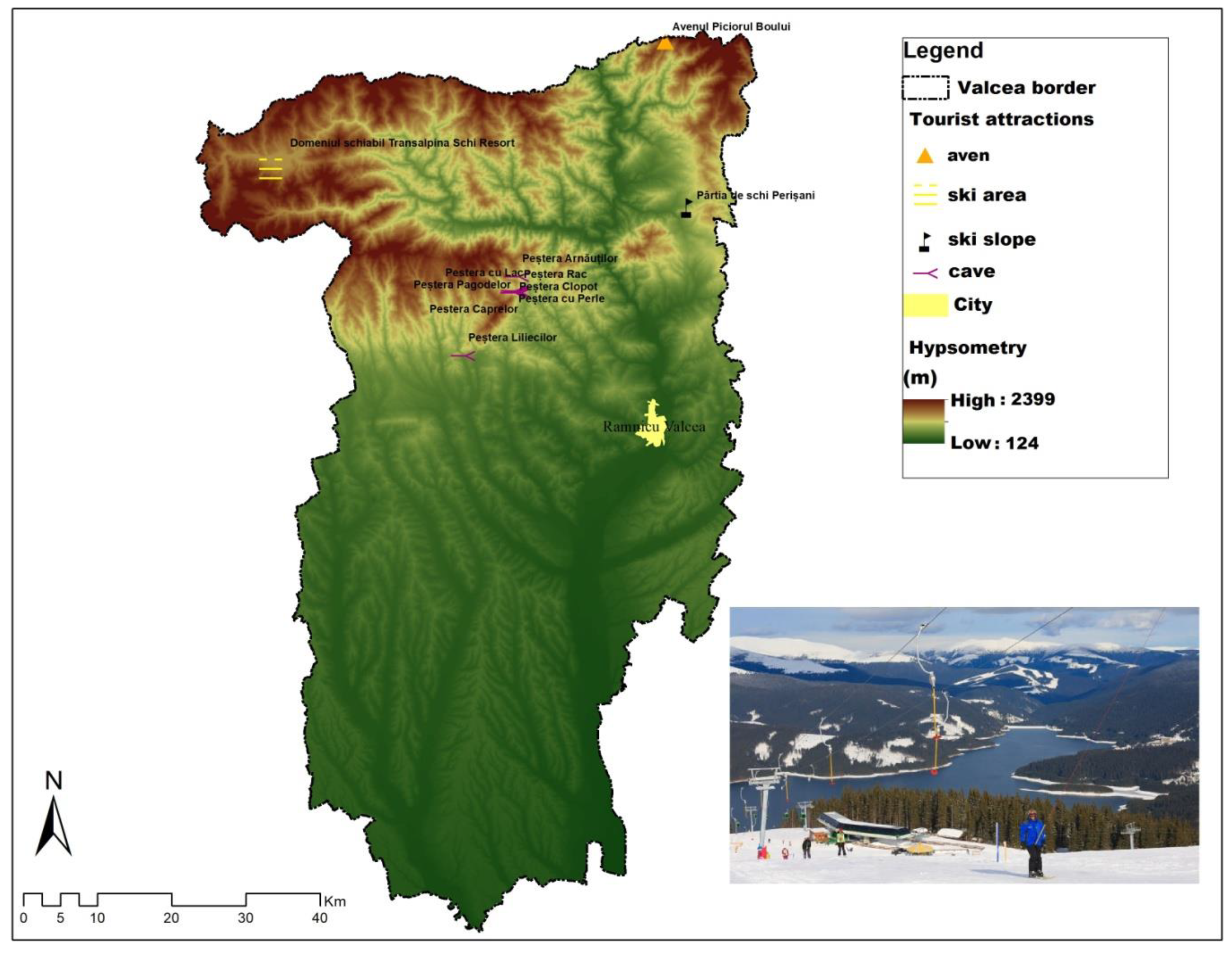
  68. Niță, A.; Drăguleasa, I.-A. Perception and development of rural tourism in Vâlcea county. An. Univ. Geogr. 2022, 23, 73–97. [Google Scholar] [CrossRef]
  69. Turism, Metadate—Biroul Național de Statistică. Available online: https://statistica.gov.md/public/files/Metadate/Turism.pdf (accessed on 23 September 2022).
  70. Erdeli, G.; Cucu, V. România: Populație. Așezări Umane. In Economie, Transversal; Publishing House: București, Romania, 2007. [Google Scholar]
  71. Cocean, P.; Filip, S. Geografia Regională a României. Ediția a II-a; Editura Presa Universitară Clujeană: Cluj-Napoca, Romania, 2011. [Google Scholar]
  72. Cocean, P. Geografie Regională. Ediția a III-A; Editura Presa Universitară Clujeană: Cluj-Napoca, Romania, 2010. [Google Scholar]
  73. Available online: https://www.openstreetmap.org/export#map=8/45.487/23.450 (accessed on 17 August 2022).
  74. Available online: http://www.mmediu.ro/articol/date-gis/434 (accessed on 17 August 2022).
  75. Available online: http://www.anpm.ro/documents/19431/40398961/PATJ+DOLJ_var1.pdf/500e6298-baf2-4817-ba27-d34eb63dbbd4#:~:text=Planul%20de%20amenajare%20a%20teritoriului,teritoriul%20pe%20care%20il%20gestioneaz%C4%83 (accessed on 17 August 2022).
  76. Available online: https://www.cjgorj.ro/consiliul_judetean_gorj/activitati/urbanism-si-amenajarea-teritoriului/p-a-t-j-gorj/ (accessed on 18 August 2022).
  77. Available online: https://www.cjmehedinti.ro/web/guest/plan-strategic (accessed on 18 August 2022).
  78. Available online: https://www.cjolt.ro/pozearticole/documente/cjolt/gallery/patj-olt/patj-olt-2014.pdf (accessed on 18 August 2022).
  79. Available online: http://www.cjvalcea.ro/index.php/urbanism-si-amenajarea-teritoriului/plan-de-amenajare-a-teritoriului-judetean-valcea-partea-1 (accessed on 18 August 2022).
  80. Cocean, P. Geografia Regională a României. Ediția a III-a; Presa Universitară Clujeană Publishing House: Cluj-Napoca, Romania, 2010. [Google Scholar]
  81. Ianoș, I. Sisteme Teritoriale, o Abordare Geografică; Editura Tehnică: Bucharest, Romania, 2000. [Google Scholar]
  82. Tsaur, S.-H.; Lin, Y.-C.; Lin, J.-H. Evaluating ecotourism sustainability from the integrated perspective of resources, community and tourism. Tour. Manag. 2006, 27, 640–653. [Google Scholar] [CrossRef]
  83. Norton, B.G. Why Preserve Natural Variety? Princeton University Press: Princeton, NJ, USA, 1987. [Google Scholar]
  84. Nistoreanu, P.; Aluculesei, A.-C. Can Spa Tourism Enhance Water Resourcec and Turn Them into a National Brand? A Theoretical Review about the Romanian Case. Information 2021, 12, 270. [Google Scholar] [CrossRef]
  85. Gössling, S. Tourism and Water. In Tourism and Global Environmental Change; Routledge: London, UK, 2015. [Google Scholar]
  86. Béki, P. Water Sports on the Hungarian Sports. In Some Recent Research from Economics and Business Studies; Karlovitz, T.J., Ed.; International Research Institute SRO: Komárno, Slovakia, 2018; pp. 81–90. [Google Scholar]
  87. Cristian-Constantin, D.; Radu-Daniel, P.; Daniel, P.; Laura Georgiana, C.; Igor, S. The Role of SPA Tourism in the Development of Local Economies from Romania. Procedia Econ. Financ. 2015, 23, 1573–1577. [Google Scholar] [CrossRef]
  88. Antonelli, M.; Donelli, D. Respiratory rehabilitation for post-COVID-19 patients in spa centers: First steps from theory to practice. Int. J. Biometeorol. 2020, 64, 1811–1813. [Google Scholar] [CrossRef]
  89. Sinan, K. Spa therapy (balneotherapy) for rehabilitation of survivors of COVID-19 with persistent symptoms. Med. Hypotheses 2021, 146, 110472. [Google Scholar] [CrossRef]
  90. Molinillo, S.; Ekinci, Y.; Whyatt, G.; Occhiocupo, N.; Stone, M. Private Label Management: Insights and Research Directions. In Handbook of Research on Strategic Retailing of Private Label Products in a Recovering Economy; IGI Global: Hershey, PA, USA, 2016. [Google Scholar] [CrossRef] [Green Version]
  91. Aluculesei, A.-C.; Nistoreanu, P.; Avram, D.; Nistoreanu, B.G. Past and Future Trends in Medical Spas: A Co-Word Analysis. Sustainability 2021, 13, 9646. [Google Scholar] [CrossRef]
  92. Oleśniewicz, P.; Pytel, S.; Markiewicz-Patkowska, J.; Szromek, A.R.; Jandová, S. A Model of the Sustainable Management of the Natural Environment in National Parks—A Case Study of National Parks in Poland. Sustainability 2020, 12, 2704. [Google Scholar] [CrossRef] [Green Version]
  93. Burchard-Dziubińska, M.; Rzeńca, A.; Drzazga, D. Zrównoważony Rozwój: Naturalny Wybór; Wydawnictwo Uniwersytetu Łódzkiego: Lodz, Polonia, 2014. [Google Scholar]
  94. IUCN. 2018 IUCN (n.d.), Category II: National Park. Available online: https://www.iucn.org/theme/protected-areas/about/protected-areas-categories/category-ii-national-park (accessed on 4 February 2020).
  95. Wang, J.Z. National parks in China: Parks for people or for the nation? Land Use Policy 2019, 81, 825–833. [Google Scholar] [CrossRef]
  96. Kaffashi, S.; Yacob, M.R.; Clark, M.S.; Radam, A.; Mamat, M.F. Exploring visitors’ willingness to pay to generate revenues for managing the National Elephant Conservation Center in Malaysia. For. Policy Econ. 2015, 56, 9–19. [Google Scholar] [CrossRef]
  97. O’Hara, K.L.; Ina, A.B.; Diaci, J.; Anić, I.; Boydak, M.; Curovic, M.; Govedar, Z.; Grigoriadis, N.; Ivojevic, S.; Keren, S.; et al. Culture and silviculture: Origins and evolution of silviculture in Southeast Europe. Int. For. Rev. 2018, 20, 130–143. [Google Scholar] [CrossRef]
  98. Crespo-Cebada, E.; Díaz-Caro, C.; Robina-Ramírez, R.; Sánchez-Hernández, M.I. Is Biodiversity a Relevant Attribute for Assessing Natural Parks? Evidence from Cornalvo Natural Park in Spain. Forests 2020, 11, 410. [Google Scholar] [CrossRef] [Green Version]
  99. Kang, M.; Gretzel, U. Effects of podcast tours on tourist experiences in a national park. Tour. Manag. 2012, 33, 440–455. [Google Scholar] [CrossRef] [Green Version]
  100. Sorakunnas, E. Dimensions and drivers of national park experiences: A longitudinal study of independent visitors. J. Outdoor Recreat. Tour. 2020, 31, 100311. [Google Scholar] [CrossRef]
  101. Rice, L.W.; Taff, B.D.; Miller, Z.D.; Newman, P.; Zipp, K.Y.; Pan, B.; Newton, J.N.; D’Antonio, A. Connecting motivations to outcomes: A study of park visitors’ outcome attainment. J. Outdoor Recreat. Tour. 2020, 29, 100272. [Google Scholar] [CrossRef]
  102. Walls, A.R.; Okumus, F.; Wang, Y.R.; Kwun, D.J.-W. An epistemological view of consumer experiences. Int. J. Hosp. Manag. 2011, 30, 10–21. [Google Scholar] [CrossRef]
  103. Popescu, L.; Bădiță, A.; Băloi, I.; Mazilu, M. Competitiv, Durabil, Inovativ și Identitar în Conturarea Destinației Turistice Oltenia, 2015, Editura Universitaria, Craiova, Romania. Available online: https://www.academia.edu/13269532/Competitiv_durabil_inovativ_si_identitar_in_conturarea_destinatiei_turistice_Oltenia (accessed on 5 January 2022).
  104. Cîrstea, G.; Constantinescu, D. Vîlcea. In Monografie; Editura Sport-Turism: Bucharest, Romania, 1980. [Google Scholar]
  105. Badea, L.; Rusenescu, C. Județul Vâlcea; Editura Academiei, R.S.R.: Bucharest, Romania, 1970. [Google Scholar]
  106. Wen, Z. China’s domestic tourism: Impetus, development and trends. Tour. Manag. 1997, 18, 565–571. [Google Scholar] [CrossRef]
  107. Wu, B.; Zhu, H.; Xu, X. Trends in China’s domestic tourism development at the turn of the century. Int. J. Contemp. Hosp. Manag. 2000, 12, 296–299. [Google Scholar] [CrossRef]
  108. Adamov, T.; Ciolac, R.; Iancu, T.; Brad, I.; Peț, E.; Popescu, G.; Șmuleac, L. Sustainability of Agritourism Activity. Initiatives and Challenges in Romanian Mountain Rural Regions. Sustainability 2020, 12, 2502. [Google Scholar] [CrossRef] [Green Version]
  109. Ciolac, R.; Rujescu, C.; Constantinescu, S.; Adamov, T.; Dragoi, M.C.; Lile, R. Management of a Tourist Village Establishment in Mountainous Area through Analysis of Costs and Incomes. Sustainability 2017, 9, 875. [Google Scholar] [CrossRef] [Green Version]
  110. Nistoreanu, P. Turismul Rural-O Afacere Mică cu Perspective Mari; Editura Didactică şi Pedagogică: Bucharest, Romania, 1999. [Google Scholar]
  111. Ciolac, R.; Csosz, I.; Rujescu, C.; Nita, S.; Ilie, A.; Bogdan, N. Managerial approach of rural tourism through holiday village-realities and profitability. J. Biotechnol. 2012, 161, 21. [Google Scholar] [CrossRef]
  112. Institutul Național de Statistică, TEMPO. Available online: http://statistici.insse.ro:8077/tempo-online/#/pages/tables/insse-table (accessed on 21 September 2022).
  113. Pongsiri, M.J.; Roman, J.; Ezenwa, V.O.; Goldberg, T.L.; Koren, H.S.; Newbold, S.C.; Ostfeld, R.S.; Pattanayak, S.K.; Salkeld, D.J. Biodiversity loss affects global disease ecology. BioScience 2009, 59, 945–954. [Google Scholar] [CrossRef]
  114. Labonte, R.; Mohindra, K.; Schrecker, T. The growing impact of globalization for health and public health practice. Annu. Rev. Public Health 2011, 32, 263–283. [Google Scholar] [CrossRef] [Green Version]
  115. Fernandes, S.; Ferreira, D.; Alves, T.; de Sousa, B.M.B. Glamping and the Development of Sustainable Tourism: A Portuguese Case Study. In Handbook of Sustainable Development and Leisure Services; World Sustainability Series; Lubowiecki-Vikuk, A., de Sousa, B.M.B., Derčan, B.M., Filho, W.L., Eds.; Springer: Cham, Switzerland, 2021; pp. 201–222. [Google Scholar] [CrossRef]
  116. Craig, C.A.; Karabas, I. Glamping after the coronavirus pandemic. Tour. Hosp. Res. 2021, 21, 251–256. [Google Scholar] [CrossRef]
  117. Brooker, E.; Joppe, M. Trends in camping and outdoor hospitality—An international review. J. Outdoor Recreat. Tour. 2013, 3–4, 1–6. [Google Scholar] [CrossRef]
  118. Ceballos-Lascurain, H. Tourism, Ecotourism, and Protected Areas: The State of Nature-Based Tourism around the World and Guidelines for Its Development; IUCN: Cambridge, UK, 1996. [Google Scholar]
  119. McCool, S.F.; Watson, A.E. (Eds.) Linking Tourism, the Environmental, and Sustainability; General Technical Reports INNNT-GTR-323; USDA, Forest Service, Intermiuntain Research Station: Ogden, UT, USA, 1995. [Google Scholar]
  120. Briassoulis, H. Sustainable Development and its Indicators: Through a Planner’s Glass Darkly. J. Environ. Plan. Manag. 2001, 44, 409–427. [Google Scholar] [CrossRef]
  121. Twining-Ward, L.; Butler, R. Implementing STD on a Small Island: Development and Use of Sustainable Tourism Development Indicators in Samoa. J. Sustain. Tour. 2002, 10, 363–387. [Google Scholar] [CrossRef]
  122. Dorobanţu, M.R.; Nistoreanu, P. Hospitality—A component of Romanian rural tourism products. Cactus Tour. J. 2012, 3, 17–23. [Google Scholar]
  123. UNWTO. Ecotourism and Protected Areas. 2020. Available online: https://www.unwto.org/sustainable-development/ecotourism-and-protected-areas (accessed on 23 June 2021).
  124. Fennell, D.A. Ecotourism. In ternational Encyclopedia of Human Geography. In Department of Tourism and Environment; Brock University: St. Catharines, ON, Canada, 2020; pp. 51–55. [Google Scholar]
  125. Nistoreanu, P.; Aluculesei, A.-C.; Avram, D. Is Green Marketing a Label for Ecotourism? The Romanian Experience. Information 2020, 11, 389. [Google Scholar] [CrossRef]
  126. Ruiz-Real, J.L.; Uribe-Toril, J.; Gázquez-Abad, J.C. Destination branding: Opportunities and new challenges. J. Destin. Mark. Manag. 2020, 17, 100453. [Google Scholar] [CrossRef]
  127. Buhalis, D.; Park, S. Brand management and concreation lessons from tourism and hospitality: Introduction to the special issue. J. Prod. Brand Manag. 2021, 30, 1–11. [Google Scholar] [CrossRef]
  128. Ritchie, J.R.B.; Ritchie, J.B.R. The Branding of Tourism destination. In Past Achievements and Future Challenges. In Proceedings of the 1998 Annual Congress of the International Association of Scientific Experts in Tourism, Destination Marketing: Scopes and Limitations; Keller, P., Ed.; International Association of Scientific Experts in Tourism: Marrakech, Morocco, 1998; pp. 89–116. [Google Scholar]
  129. Stăncioiu, A.-F.; Teodorescu, N.; Pârgaru, I.; Vlădoi, A.-D.; Băltescu, C. Imaginea destinației turistice—Element de susținere în construcția brandului turistic regional. Studiu de caz: Muntenia. Econ. Teor. Și Apl. 2011, 17, 139–152. [Google Scholar]
  130. Govers, R.; Go, F. Place Branding: Glocal, Virtual, and Physical Identities, Constructed, Imagined and Experienced; Palgrave Macmillan: London, UK, 2009. [Google Scholar]
  131. Kim, K.; Uysal, M.; Sirgy, J.M. How does tourism in a community impacts the quality of life of community ersidents? Tour. Manag. 2013, 36, 527–540. [Google Scholar] [CrossRef]
  132. Lupi, C.; Giaccio, V.; Mastronardi, L.; Giannelli, A.; Scardera, A. Exploring the features of agritourism and its contribution to rural development in Italy. Land Use Policy 2017, 64, 383–390. [Google Scholar] [CrossRef]
  133. Turnock, D. Sustainable rural tourism in romanian Carpatians. Geogr. J. 1999, 165, 192–199. [Google Scholar] [CrossRef]
  134. Marin, D. Study on the economic impact of tourism and of agritourism on local communities. Res. J. Agric. Sci. 2015, 47, 160–163. [Google Scholar]
  135. Ciolac, R.; Adamov, T.; Iancu, T.; Popescu, G.; Lile, R.; Rujescu, C.; Marin, D. Agritourism—A sustainable development factor for improving the ‘health’ of rural settlements. Case study apuseni mountains area. Sustainability 2019, 11, 1467. [Google Scholar] [CrossRef] [Green Version]
  136. Călina, A.; Călina, J.; Iancu, T. Research regarding the implementation, development and impact of Agritourism on Romania’s rural areas between 1990 and 2015. Environ. Eng. Manag. J. 2017, 16, 157–168. [Google Scholar] [CrossRef]
  137. Istrate, I.; Bran, F.; Roşu, G. Economia Turismului şi Mediul Înconjurător; Editura Economică: Bucharest, Romania, 1996. [Google Scholar]
  138. Hall, R.D.; Kirkpatrick, I.; Mitchell, M. Rural Tourism and Sustainable Business; Channel View Publications: Bristol, UK, 2005. [Google Scholar]
  139. Font, X.; Mccabe, S. Sustainability and marketing in tourism: Its contexts, paradoxes, approaches, challenges and potential. J. Sustain. Tour. 2017, 25, 869–883. [Google Scholar] [CrossRef]
  140. Alén, E.; Losada, N.; Domínguez, T. The Impact of Ageing on the Tourism Industry: An Approach to the Senior Tourist Profile. In Social Indicators Research: An International and Interdisciplinary Journal for Quality-of-Life Measurement; Springer: Berlin/Heidelberg, Germany, 2016; Volume 127, pp. 303–322. [Google Scholar]
  141. Dann, G.M.S. Senior Tourism and Quality of Life. J. Hosp. Leis. Mark. 2002, 9, 5–19. [Google Scholar] [CrossRef]
  142. UNWTO. Young People Must Be Active Participants as We Rethink and Restart Tourism, News on 7 July 2022. Available online: https://www.unwto.org/news/young-people-must-be-active-participants-as-we-rethink-and-restart-tourism (accessed on 17 January 2023).
  143. Light, D.; Creţan, R.; Dunca, A.M. Education and post-communist transitional justice: Negotiating the communist past in a memorial museum. Southeast Eur. Black Sea Stud. 2019, 19, 565–584. [Google Scholar] [CrossRef]
  144. Light, D.; Creţan, R.; Dunca, A.-M. Museums and Transitional Justice: Assessing the Impact of a Memorial Museum on Young People in Post-Communist Romania. Societies 2021, 11, 43. [Google Scholar] [CrossRef]
Figure 1. The characteristics of the natural setting attractiveness. Source: adaptation after [39].
Sustainability 15 02018 g001
Figure 2. The geographical-chorematic models. Source: adaptation after [63,65].
Sustainability 15 02018 g002
Figure 3. The geographical location of the counties of the South-West Oltenia region at national level. Source: data processed by authors in ArcGIS 10.1.
Sustainability 15 02018 g003
Figure 4. The chorema of Northern Oltenia. Source: data processed by authors in ArcGIS 10.1.
Sustainability 15 02018 g004
Figure 5. The Chorema of Southern Oltenia. Source: data processed by authors in ArcGIS 10.1.
Sustainability 15 02018 g005
Figure 6. The hypsometry and the hydrographic network of the South-West Oltenia region. Source: data processed by authors in ArcGIS 10.1.
Sustainability 15 02018 g006
Figure 7. The geospatial location of national and natural parks in Oltenia. Source: data processed by authors in ArcGIS 10.1 using OpenStreetMap (OSM) (open source) [73].
Sustainability 15 02018 g007
Figure 8. The avifaunistic special protection areas and sites of community importance within Oltenia. Source: data processed by authors in ArcGIS 10.1 using OpenStreetMap (OSM) (open source) [73].
Sustainability 15 02018 g008
Figure 9. The net utilization index of tourist accommodation capacity in operation. Source: data processed by authors.
Sustainability 15 02018 g009
Figure 10. The number of accommodation units in Oltenia. Source: data processed by authors according to NIS [112].
Sustainability 15 02018 g010
Figure 11. The existing tourist accommodation capacity in Oltenia. Source: data processed by authors according to NIS [112].
Sustainability 15 02018 g011
Figure 12. The tourist accommodation capacity in operation in Oltenia. Source: data processed by authors according to NIS [112].
Sustainability 15 02018 g012
Figure 13. The territorial localization of the form of sustainable tourism—glamping. Source: data processed by authors in ArcGIS 10.1.
Sustainability 15 02018 g013
Figure 14. The geographical location of Cozia and Buila-Vânturarița National Parks. Source: data processed by authors in ArcGIS 10.1.
Sustainability 15 02018 g014
Figure 15. The mix of forms of tourism in Oltenia. Source: data processed by authors in ArcGIS 10.1.
Sustainability 15 02018 g015
Figure 16. The proposal for the Logo of Oltenia region. Source: data processed by authors.
Sustainability 15 02018 g016
Table 1. The actions, programs and projects for the sustainable tourism development of Oltenia.
Action 1: Tourism Infrastructure
ProgramProjects
Modernization of tourism infrastructure1. Development of the general access infrastructure to the protected areas in Vâlcea, Gorj and Mehedinți;
2. The establishment of tourist information/documentation centres;
3. Restoring the access infrastructure to natural and man-made tourist attractions for the creation of new tourist circuits;
4. The introduction of the Oltenia de sub Munte Geopark into tourist circuits—aspiring to be included in the UNESCO heritage.
Creation of new tourist areas1. The development and organization of leisure areas on the banks of the Danube;
2. Organization of hunting and fishing festivals in Mehedinți.
Restoration of tourist heritage1. Restoration of the cultural-historical tourist heritage of the region;
2. Rehabilitation of buildings in urban centres;
3. Modernization of parks, botanical gardens, and urban green spaces.
Action 2: Tourism promotion
ProgramProject
County, national and international promotion of tourist heritage1. Establish centres for the sale and purchase of ecological products from Oltenia;
2. Promotion of natural tourism products at traditional fairs and festivals;
3. The creation of innovative and competitive tourist packages from the point of view of the sustainable development of the region;
4. Participation of producers in international fairs and festivals;
5. Organizing a tourism fair in Oltenia.
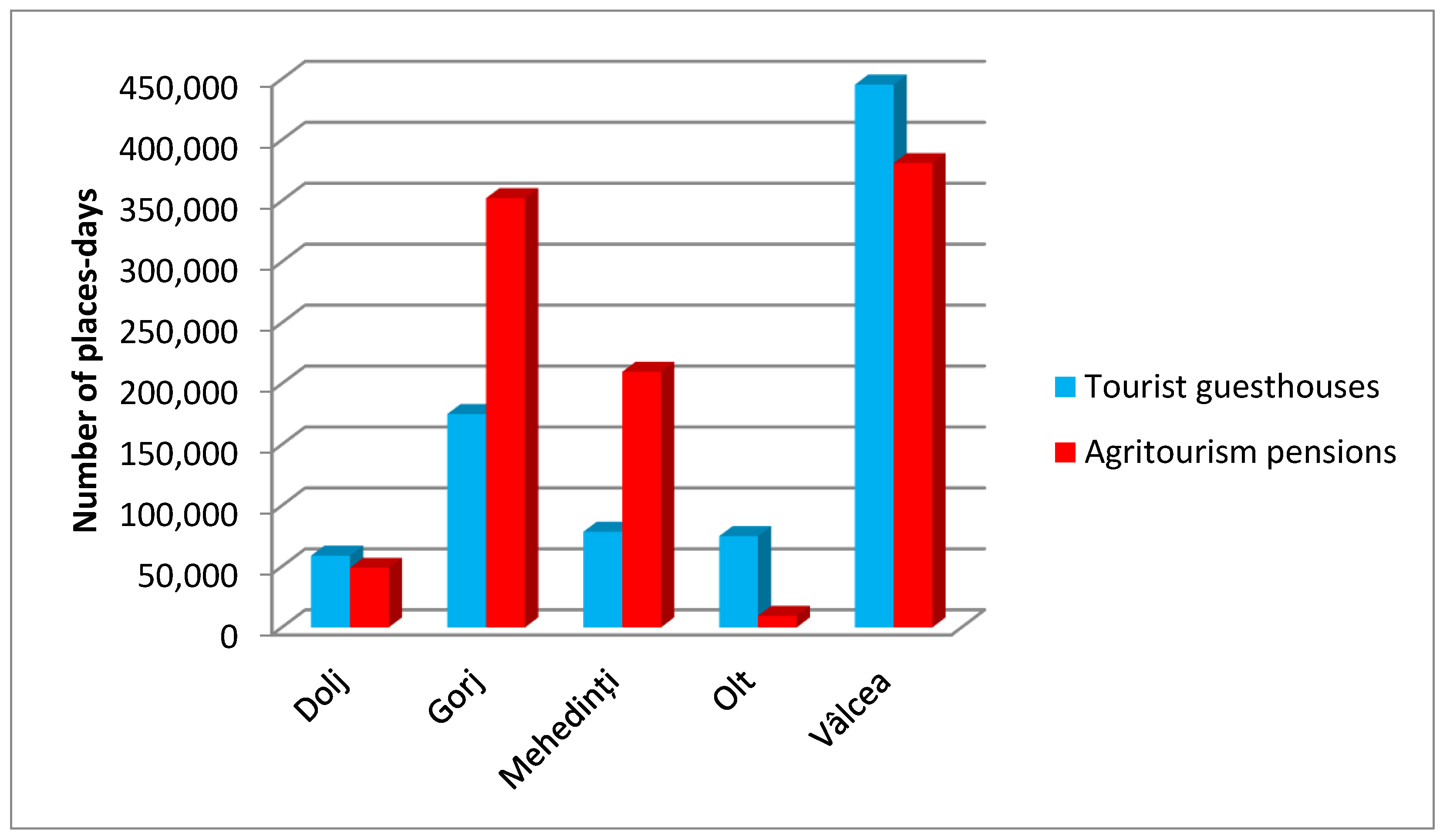
Source: data processed by authors.
Table 2. Tourist accommodation units at the county level.
Item. No.CountiesTourist Guesthouses (Number)Agritourism Guesthouses (Number)
1.Dolj119
2.Gorj3497
3.Mehedinți1461
4.Olt94
5.Vâlcea7783
Source: data processed by authors according to NIS [112].
Disclaimer/Publisher’s Note: The statements, opinions and data contained in all publications are solely those of the individual author(s) and contributor(s) and not of MDPI and/or the editor(s). MDPI and/or the editor(s) disclaim responsibility for any injury to people or property resulting from any ideas, methods, instructions or products referred to in the content.

