Project Report

Rapid Earthquake Damage Assessment and Education to Improve Earthquake Response Efficiency and Community Resilience

by
Konstantinos Papatheodorou
1,*,
Nikolaos Theodoulidis
2,
Nikolaos Klimis
3,
Can Zulfikar
4,
Dragos Vintila
5,
Vladlen Cardanet
6,
Emmanouil Kirtas
1,
Dragos Toma-Danila
5,
Basil Margaris
2,
Yasin Fahjan
4,
Georgios Panagopoulos
1,
Christos Karakostas
2,
Georgios Papathanassiou
7 and
Sotiris Valkaniotis
3
1
Departments of Surveying Engineering and Civil Engineering, Serres Campus, International Hellenic University, 62100 Serres, Greece
2
Institute of Engineering Seismology & Earthquake Engineering, 55535 Thessaloniki, Greece
3
Department of Civil Engineering, Democritus University of Thrace, 67100 Xanthi, Greece
4
Department of Civil Engineering, Gebze Technical University, 41400 Kocaeli, Turkey
5
Department of Civil Engineering, Ovidius University of Constanta, 900527 Constanta, Romania
6
Institute of Geology & Seismology of Moldova, MD2009 Chisinau, Moldova
7
Department of Geology, Aristotle University of Thessaloniki, 54124 Thessaloniki, Greece
*
Author to whom correspondence should be addressed.
Sustainability 2023, 15(24), 16603; https://doi.org/10.3390/su152416603
Submission received: 16 October 2023 / Revised: 19 November 2023 / Accepted: 27 November 2023 / Published: 6 December 2023

Abstract

:
Southeastern Europe faces a significant earthquake threat, endangering lives, property, and infrastructure thus jeopardizing sustainable development. The development of a Rapid Earthquake Damage Assessment System (REDAS) designed to deliver crucial earthquake damage information for scenario planning, real-time response, and bolstering public awareness and preparedness is presented. In doing so, REDAS enhances community resilience and safeguards sustainability. REDAS comprises a Rapid Earthquake Damage Assessment platform (REDA.p), a smartphone application, and an Educational Hub (Edu.Hub). REDA.p provides both scenario-based and near real-time seismic damage evaluation of structures, gas pipelines, and geotechnical failures, based on harmonized Ground Motion Prediction Equations and a comprehensive building taxonomy scheme covering the area under investigation. To assess regional landslide hazards, the Infinite Slope Model and a statistics-based model have been implemented, alongside a statistical model for liquefaction probability assessment. Validated against historical data, REDA.p integrates real-time input from key earthquake monitoring networks in the region, covering cross-border areas as well, while in designated urban zones, the system is enhanced by real-time data from a dense earthquake monitoring network deployed in selected school buildings. The smartphone app and Edu.Hub disseminate critical information, guidelines, and tools to improve public prevention, preparedness, and response capacities, thereby enhancing societal resilience.

1. Introduction

Earthquakes are a recurring natural hazard in southeastern Europe and around the Black Sea area [1,2,3,4,5,6,7,8,9], with the potential to cause substantial damage to infrastructure, endanger lives, and disrupt communities. This fact, combined with the expansion of built environment and infrastructure during the past decades [10,11], has led to a dramatic increase in the elements at risk. In addition, secondary phenomena triggered by strong ground motion, such as landslides and liquefaction [12,13,14], may also cause serious damage, which, in turn, can dramatically affect the environment and the socio-economic stability of society and jeopardize sustainability.
These conditions necessitate well-informed decisions for effective earthquake disaster mitigation planning by civil protection authorities. To that end, situational awareness encompassing damage distribution is vital for authorities to plan prevention, prepared-ness and response effectively. Up to date, earthquake-related damage assessment focuses on predefined probabilistic seismic scenarios; therefore, existing seismic vulnerability studies cannot fully provide, especially in real time, the expected damage pattern of a seismic event. Therefore, the development of a rapid earthquake damage assessment platform (REDA.p) to provide scenario-based earthquake damage information for disaster mitigation planning and real-time response actions is imperative.
Countries in the area have developed their own policies, technical expertise and tools to cope with seismic risk reduction and improve their earthquake disaster mitigation capacity. Seismic hazard is being systematically analyzed; however, different approaches (i.e., probabilistic, classical deterministic and neo-deterministic), as well as input seismic sources and GMPEs adopted for seismic hazard assessment, often lead to different, even partially conflicting maps of seismic hazard, especially in Cross Border Areas (CBA). On the other hand, modern seismic networks operating in the area facilitate real-time data exchange through ORFEUS EIDA nodes and also over direct data-exchange agreements.
Although exposure datasets exist for the entire area [15,16,17], the level of detail differs between countries. Thus, existing datasets cannot uniformly cover cross border areas, leading to output limitations.
The vulnerability assessment methods used are also quite different due to both the characteristics of the building stock in each country (local construction practices, different materials, variation in codes and regulations, etc.), as well as because of the methodological approaches adopted. Comprehensive state-of-the-art reviews and efforts focusing on the development of extensive databases of existing vulnerability functions can be found in the literature [18,19,20,21,22,23,24,25,26]. The existing variety of methods used to assess earthquake damage on buildings and specific infrastructure (road or railway networks, dams, utility networks, etc.), includes empirical (intensity based, relying on empirical fragility curves, etc.), analytical (capacity-spectrum, MADRS, improved-displacement coefficient, etc.), and even hybrid ones. It must be noted that vulnerability models developed for building typologies in any specific country/region are generally not applicable in other places of the world, unless the compatibility tests carried out (if any) show that there is good correspondence between specific typologies. At the same time, efforts have been made within the framework of international research projects to propose vulnerability functions for the entire European continent, such as the SERA, RiskUE, Syner-G, NERA, PERPETUATE, ESRM2020 [27,28,29,30,31,32] projects. In recent years, the rapid development of machine learning methods and artificial intelligence has led to the development of advanced procedures that are directed towards achieving a quicker and more reliable depiction of the existing building stock in urban areas, as well as focusing on the development of improved fragility curves and vulnerability indexes [33,34,35,36,37,38,39,40,41].
As it therefore seems, and in order to develop an efficient REDA.p, harmonization across all aspects of earthquake hazard and risk assessment is needed.
Earthquake-imposed crises invoke the entire community with all of its components, including the population (Public). Response of the Public strongly affects the dynamics and progress of response actions, both during the event, and after that, and is strongly related to the level of communication in comprehending the situation and in being trained to respond. To that end, policies towards improving public prevention, preparedness and response capacities through education and raising awareness actions are necessary.
Public behavior is usually motivated by personal concerns, so their main concerns during an emergency must also be considered when developing educational and awareness raising material. To that end, situational awareness regarding those concerns at a personal level should also be acquired during emergencies.
To date, prevention measures aiming to minimize earthquake consequences on built environment and society are mainly based on seismic code provisions (National Codes, EC8), as well as emergency response plans on local and regional scales depending on the event magnitude and intensity.
At the same time, a number of scenario-based REDA platforms for earthquake damage assessment exist, including HAZUS [42], ELER [43], PAGER [44], SELENA [45], Open Quake [46], AFAD Red [47]. These tools showcase numerous valuable capabilities; however, extensive data requirements and limitations, particularly concerning real-time REDA, hinder these solutions from delivering the anticipated outputs and providing real-time situational awareness to competent authorities. A more extensive summary of already existing REDA software v.1.2.3 can be found in project deliverables (https://www.redact-project.eu/) which will be available during February 2024
Taking into consideration everything mentioned thus far, and to support well informed decisions regarding earthquake disaster mitigation, a Rapid Earthquake Damage Assessment (RE-DA) platform that can provide scenario based and real-time earthquake damage assessment by combining information from any of the available monitoring networks is needed. To that end, harmonization of policies, strategies, methodologies and activities involved in Earthquake Disaster mitigation over developing a framework for common practices and joint actions in this field is also necessary.
The report that follows comprises several sections corresponding to the different parts that make up the project “Rapid Earthquake Damage Assessment Consortium”, and all with their individual significance: coordination and management, Earthquake Hazard Assessment, Risk Assessment, Geotechnical failures, Geoinformatics platform development, a smartphone app and the Educational Hub. Harmonization, as an essential part of the project, is a prerequisite for all of the specified sections.

2. The REDACt Project Methodology

2.1. Project Objectives, Targets, Expected Results

REDACt aims at contributing to Earthquake Disaster mitigation by intervening in three of the basic disaster mitigation stages, Prevention—Preparedness—Response, through improving the operational capacity of Civil Protection authorities and public response.
This entire action is split into two parts, implemented in parallel:
  • The first one is to develop, as a Decision Supporting System, a Rapid Earthquake Damage Assessment platform (REDA.p) which can support authorities to make informed decisions during the Prevention and Preparedness phases, and to provide situational awareness during emergencies regarding the spatial distribution of the expected level of damage. REDA.p produces outputs with improved accuracy and reliability in urban areas by receiving readings from a dense monitoring network of low-cost accelerometers, installed in selected school buildings.
  • The second part of the action aims at improving Public Response always in line with State Emergency plans by:
    • Developing a smartphone app to provide guidance, best practices and the ability to provide feedback and felt reports during an emergency.
    • Developing an Educational Hub which answers problems related to public response, as identified by Competent Authorities at a National level.
The overall target of the action is to improve Emergency Response efficiency and Community resilience against earthquake-imposed risks and all of that covering Cross Border areas as well.
The proposed REDA System is based on a jointly developed framework for harmonization of all the involved parameters and methodologies, and provides:
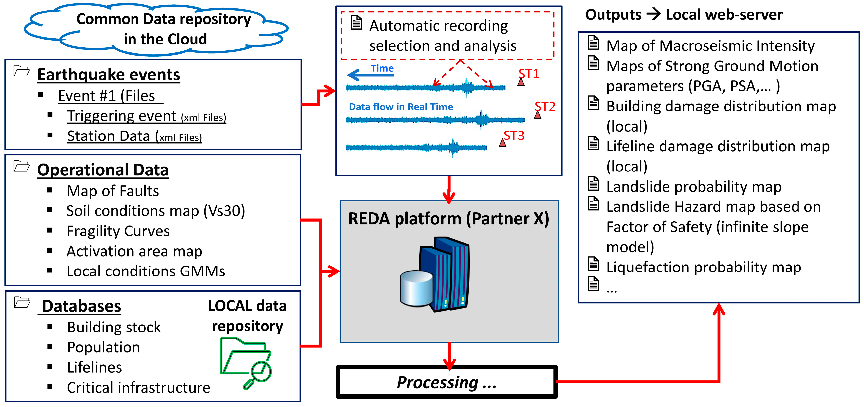
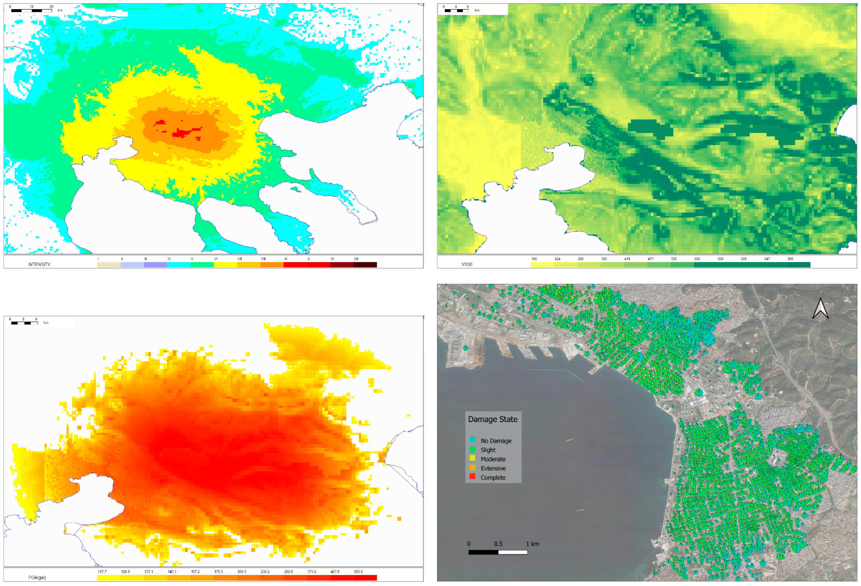
  • Both scenario-based and near Real-Time (Rapid) Earthquake Damage Assessment. The REDA.p integrates real-time seismic data from various monitoring stations from various providers including ITSAK/EPPO (Greece), NIEP (Romania) and AFAD (Türkiye) to detect earthquakes promptly. Utilizing geological, engineering geological/geotechnical and structural data, the system employs predictive models to estimate ground motion parameters and potential earthquake damage based on user defined scenarios. When triggered by any of the earthquake monitoring networks, the platform calculates ground motion parameters, produces the respective shakemaps, and, based on the available for the area vulnerability and/or geotechnical data, produces the respective earthquake damage distribution maps (Figure 1).
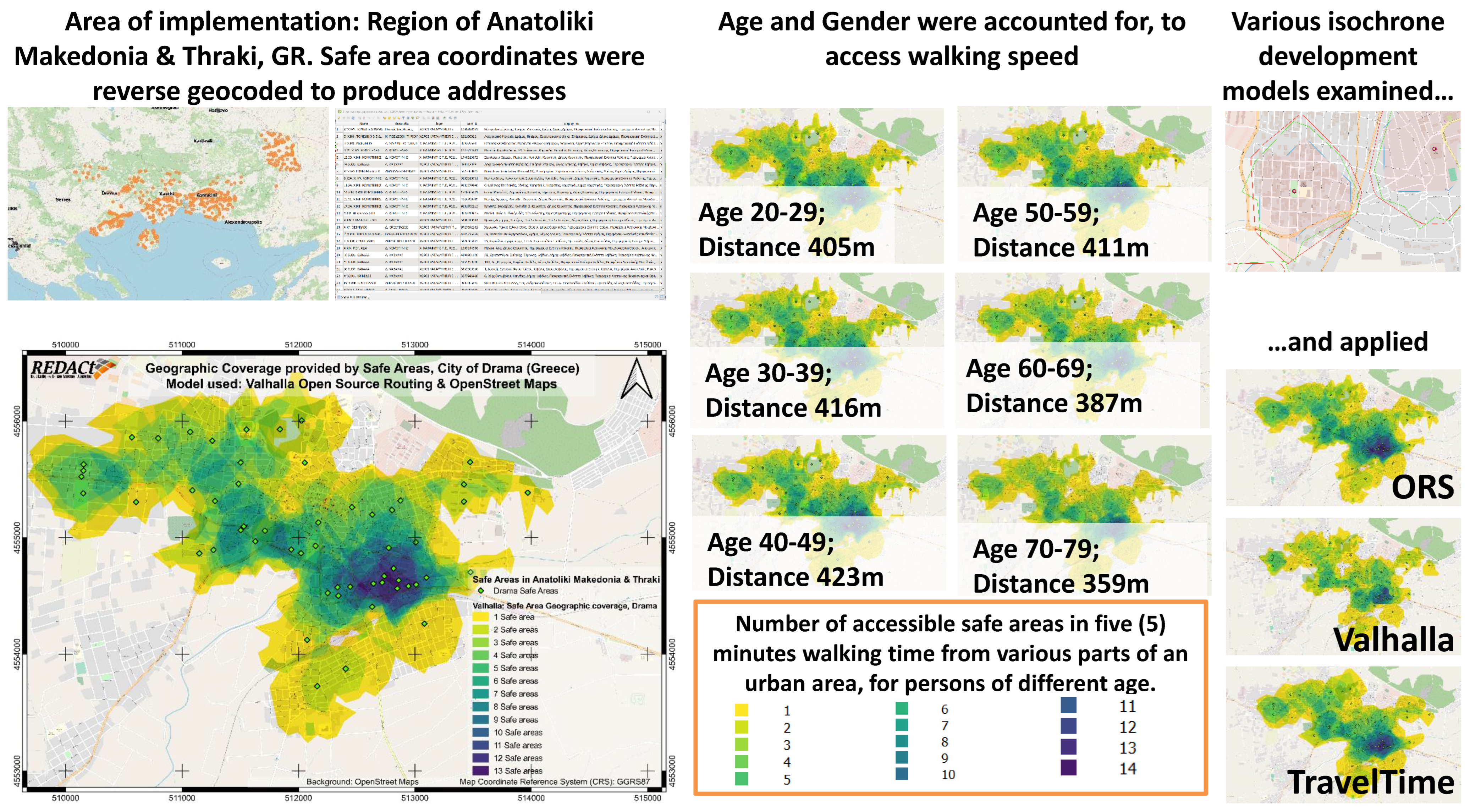
  • Smartphone app. It provides (i) education and training to users; (ii) information regarding the event; (iii) a map of safe locations in the area; (iv) the capability of sending an “I am safe” message to selected contacts; (v) the capability of sending feedback as “felt-reports”; and (vi) access to the project website where they can find more information, guidelines and tools to implement their own emergency plans.
  • Educational Hub (Edu.Hub). The scope of the educational hub is to investigate the reasons influencing public behavior during earthquake emergencies and to offer solutions for improvement. It capitalizes on educational material published by competent Authorities at National and Regional Levels and based on internationally recognized and widely acceptable principles, it attempts to constructively contribute towards improving public prevention, preparedness and response capacities against earthquake-related risks.
Research activities to build those system components include several interlinked scientific areas, including Earthquake Hazard assessment, Risk assessment, Geotechnical hazard assessment, Edu.Hub development, REDA platform development and the smartphone app development.

2.2. Project Design and Structure

Project partners include the International Hellenic University as the lead partner (GR), the Institute of Engineering Seismology and Earthquake Engineering of the Hellenic Earthquake Planning and Protection Organization, the Democritus University of Thrace (GR), the Gebze Technical University (TR), the Ovidius University of Constanta (RO) and the Institute of Geology and Seismology (MD).
Project implementation was based on regular and on-demand communication among the project implementation team and among the project and the Target Group, which includes competent in earthquake disaster mitigation authorities at National, regional and local levels, the scientific community, competent professionals and the Public.
Internal procedures were controlled and monitored by the project coordinator with the assistance of the Steering Committee (StC), comprising of the heads of partner teams. There were partners responsible for each of the groups of activities (working groups), for each activity and respective deliverable. A total number of 50 staff scientists/researchers and 9 highly qualified external experts participated in the project.
Attached to the StC was an Advisory Committee (AdC), consisting of distinguished scientists at the international level, who also hold key positions in Civil Protection (Figure 2). Members of the AdC include the President of the Hellenic Earthquake Planning Protection Organization (Greece); the Director of the Earthquake Department of Disaster and Emergency Management Presidency (AFAD, Türkiye); the general manager of the National Institute for Earth Physics (NIEP, Romania); the President of the EMSC-European Mediterranean Seismological Center; and the director of internal Protection and Prevention Service, former officer of Civil Protection (Moldova).

2.3. Research Subjects

A very broad spectrum of research subjects was applied, including seismicity assessment, strong ground motion parameter estimation, geotechnical failure model investigation (focusing on landslides and liquefactions), risk assessment, vulnerability of structures and gas pipelines, and public behavior related to natural disaster mitigation, especially during emergencies.
More technical subjects were also covered including the operational specs and development of the REDA platform, the smartphone app development, the development of a prototype platform built on geoinformatics technologies and available APIs, for assessing geotechnical hazards triggered by earthquakes, and the development of low-cost accelerometers and their installation to selected school buildings (Figure 3).

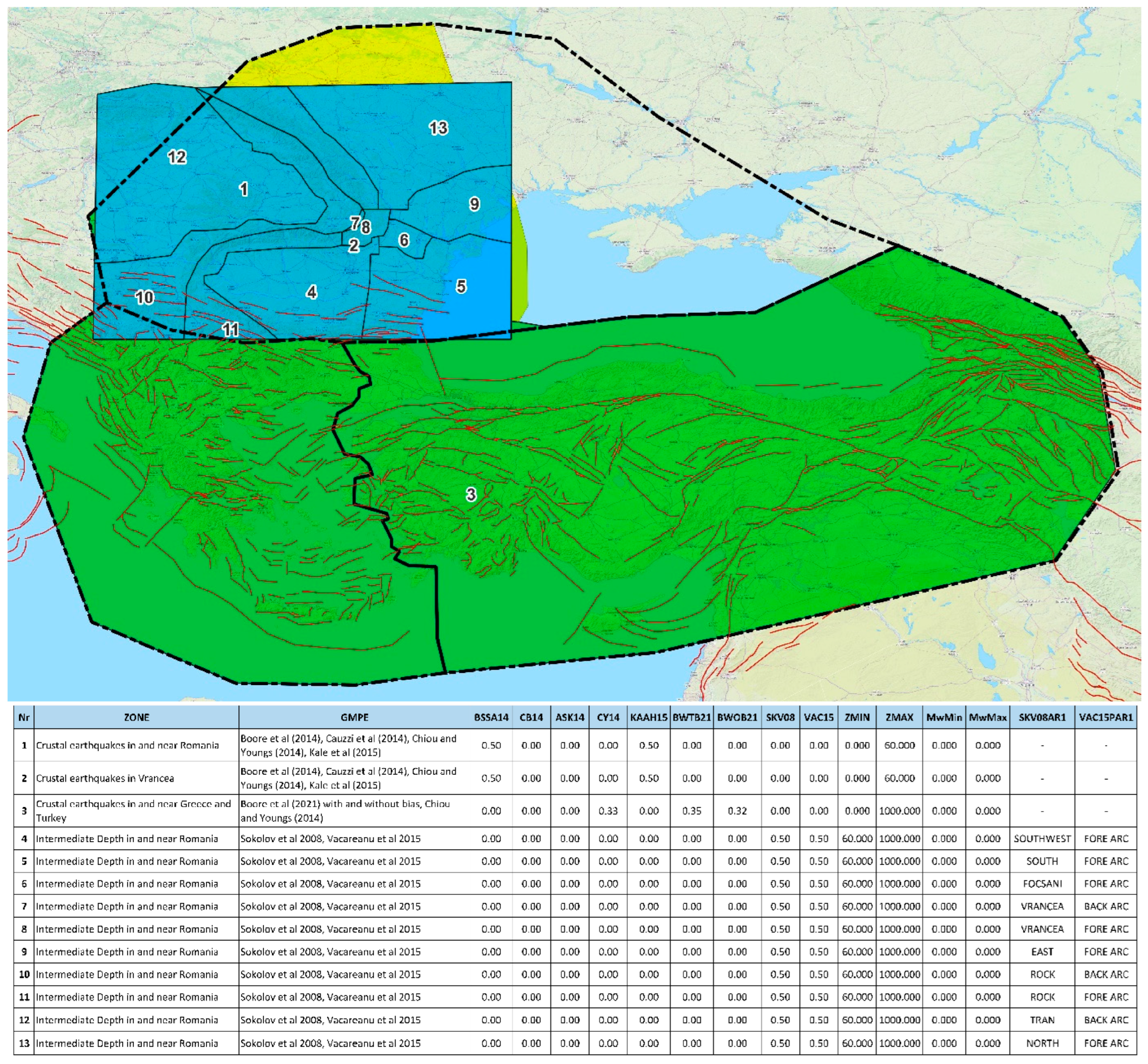
2.3.1. Ground Motion Prediction Equations and Selection of Seismic Sources

The necessary harmonization was based on the assessment of the existing status on the detection of discrepancies/incompatibilities and on research to develop solutions that fully cover the REDA.p demands in terms of accuracy, reliability and geographic coverage. Previous research indicates that various seismogenic sources and faults have been adopted and used by each country for seismic hazard map generation in the area. They provide diverging outputs, which are especially evident in Cross Border Areas (CBA) in terms of the expected ground motion intensity for a given annual probability of exceedance, making the harmonization of seismic sources and fault parameters, and of the Ground Motion Predictive Models (GMPM), a necessity.
The harmonization of seismic sources and fault parameters was based on the outputs of the SHARE EU project (2009–2013, http://www.share-eu.org; last accessed on 15 October 2023), but still, a missing part of seismogenic faults of the area between Romania and Moldova and of Ukraine and Southwestern Russia had to be covered. Towards that end, seismic sources and faults in the wider area of Romania and of the Republic of Moldova, which also covers large parts of Bulgaria and southern Ukraine, were investigated. Recent research related to the determination of seismic sources [48] and faults in the area [49] was also considered.
Ground motion predictive models’ harmonization was based on the SHARE project [6,7,8]. The REDACt research area was divided into two main categories in terms of tectonic features; one including active shallow crustal regions (ASCR), covering Greece and Turkey, and the Stable Continental Region (SCR), consisting mainly of a continental crust covering Romania, Moldova and their broader area. For this reason, two parallel investigations regarding the selection of the most appropriate Ground Motion Predictive Models (GMPM) have been completed.
To that end, thirteen out of the existing thirty-seven GMPM published during 1985–2021 were selected based on the criteria suggested by Cotton et al. [50] and Bommer et al. [51], and were tested and ranked according to their Peak Ground Acceleration (PGA) and Peak Ground Velocity (PGV) performance.
Evaluation of GMPM for the GR/TR CBA was through comparison to strong motion data recorded in both Greece and Türkiye during three events that have recently (2017–20) occurred in the Greek/Turkish CBA. The “Normalized Residuals” method was used to identify biases that may exist when implementing a specific model in a region, and the “Log-Likelihood” method [52] was used to decide if a specific GMPM is suitable for implementation, and, if so, in which way the various GMPMs are to be weighted within the epistemic uncertainty analysis in a “logic tree” framework. Although the selected evaluation approach offers an objective way of ranking the selected GMPMs, it has been observed that different evaluation approaches lead to different rankings, and, therefore, GMPMs for Probabilistic Seismic Hazard Analysis (PSHA) must be combined with corresponding weighting factors, which were finally calculated (Table 1). The same results have been derived from a similar analysis proposed by Sotiriadis and Margaris [53].
Based on the analysis, the first three GMPMs were selected to be implemented for the entire GR/TR cross border area.
A respective analysis covering Romania, Moldova and their surrounding area for evaluating the GMPMs for intermediate-depth events was based on models currently used for developing the Romanian ShakeMap [56] and on recent research [57]. Several models were tested in terms of Peak Ground Acceleration (PGA), Peak Ground Velocity (PGV) and Spectral Acceleration (SA). They were evaluated and ranked using the “Normalized Residuals” and the “Log-Likelihood” as described previously, and the highest-ranking ones were those proposed by Sokolov et al. [58], Atkinson and Boore [59], Vacareanu et al. [60] and Garcia et al. [61].
GMPMs incorporate shear wave velocity in the upper 30 m (Vs30), which is used in estimating shaking, and also in calculations related to seismic site characterization. Based on the fact that Vs30 values were found to correlate very well with topographic slope [62], Vs30 values for the entire research area were adopted from the USGS (https://earthquake.usgs.gov/data/vs30/, last accessed on 21 February 2022). These values are based on a 30 arc-sec Digital Elevation Model, and they have been used worldwide [63] as they are considered generically applicable on a global scale.
In selected pilot implementation urban areas, more detailed Vs30 value data were produced using detailed topographic and geologic maps. All of this information was incorporated into the REDA platform (Figure 4).

2.3.2. Earthquake Damage Assessment of Buildings and Gas Pipelines

Existing loss estimation methods, which are utilized globally for assessing buildings and infrastructure, were comprehensively reviewed in the project’s deliverables (made available over the project website), as well as available software solutions for rapid earthquake loss estimation. In the majority of the existing REDA systems, there is an effort to quantify the anticipated damage to buildings and structures by determining specific damage levels based on criteria that are usually associated with damage extent and repair cost.
Subsequently, these estimates can be used to calculate socio-economic impacts, both direct and indirect, typically by employing empirical models. At a systemic level (pertaining to transportation networks or lifelines), the models are generally observational and possess a high degree of uncertainty when applied to other case study areas. Available approaches are based on:
  • seismic intensity values and direct correlations with potential of casualties and economic losses;
  • seismic intensity values and vulnerability functions for buildings with casualty models;
  • seismic PGA, PGV and Sa values, capacity and fragility functions or directly vulnerability functions for structures;
  • more empirical approaches (but generally less used), relying on GIS multi-criteria decision analysis.
In most cases, the scale of analysis for the damage assessment of buildings applies to broader urban areas such as a municipality or a city. Therefore, fragility or vulnerability functions are linked to generic structural typologies rather than focusing on individual structures. Achieving harmonized seismic risk assessment of buildings across different countries introduces specific challenges due to variations in codes, regulations, local construction practices, and prevalent trends in each nation’s seismic risk assessment procedures, such as building taxonomy and seismic damage definitions. Determination of geographical units (e.g., building block, mahalla, etc.) and differences in available exposure datasets, such as the level of detail and format, also present obstacles.
To attain a unified outcome for REDA.p, key decisions were made to allow the application of common procedures, with paramount importance given to the building taxonomy and the vulnerability models used to evaluate the levels of seismic damage. To harmonize seismic loss estimation over the entire research area, the taxonomy proposed by the Global Earthquake Model [64] was adopted as the common taxonomy used for exposure datasets. The set of fragility curves proposed by Martins and Silva [65] was adopted, as it appeared to provide a reliable solution for describing the seismic performance of buildings in all partner countries and is compatible with the GEM taxonomy.
Validation of the platform results that was attempted in the city of Thessaloniki, revealed satisfactory comparison with available damage distribution data [66,67] after the Volvi earthquake (M = 6.5, 1978).
In REDA.p, the earthquake damage assessment of natural gas pipelines leverages a logic tree approach, using selected fragility curves with assigned weights to depict the performance of pipelines under wave propagation and peak ground deformation hazards. The selection of pertinent vulnerability functions is based on (a) an existing database of damaged pipelines, often supplemented with water or sewer pipelines data to augment the dataset [68]; (b) fragility curves specifically tailored to gas pipelines [69]; and (c) the relationship proposed by O’Rourke et al. [70]. Failures in water and sewage pipelines located in the broader area of Kocaeli (Türkiye) were considered for validating the efficiency of REDA.p estimations.

2.3.3. Earthquake Triggered Landslides and Liquefactions

Taking into account the regional scale of implementation, the available data and the existing methods used worldwide for the assessing the liquefaction potential and/or probability [63], the method proposed by Zhu et al. [71] was adopted for evaluating the probability of liquefaction-induced ground disruption, while for local scales, the adopted method was the one proposed by Iwasaki et al. [72].
Based on the same conditions, landslide hazard assessment at a regional scale, for events triggered by earthquakes, is made over two different approaches: (a) Jessee et al.’s [73] recently developed statistical approach, and (b) the infinite slope model (ISM); a widely used, physically based model, appropriate for shallow landslides, which has been adopted and evaluated in a previous Black Sea Basin JOP 2007-13 funded project, SciNetNatHaz [74]. Data produced for implementing the ISM were based on detailed topographic and geologic maps, and on analysis of the engineering properties of rocks and soils to assess cohesion and angle of friction values.

2.3.4. The Smartphone App

The REDACt smartphone app has been developed to provide event-related information to the public, while, at the same time, receive feedback from the public in the form of felt reports using the scheme of the well-known “Last Earthquake” app (EMSC). To support the public during emergencies, the app also allows users to send a message to selected contacts with one click. It also provides maps of safe (refuge) areas, as defined by competent authorities.

2.3.5. The Educational Hub

Education to process information and comprehend the risks are among the main requirements for improving public response capacity; therefore, a large part of the educational hub is attributed to providing targeted education, which capitalizes on guidelines issued and/or published by competent National authorities and adds some new ideas, tips and solutions to potential problems the public faces during emergencies.
Reasons the public should be prepared to respond in earthquake emergencies in line with state emergency plans, what and how to do it to mitigate the risks, and info regarding the content of the Hub, introduce the visitor into the essentials regarding earthquake disaster mitigation and the necessary participation of the public in this effort. Suggestions are provided for voluntary involvement at a neighborhood level. Care has been taken to provide explanations and justifications for necessary actions per case.
As response of the population strongly affects the progress and evolution of response actions, both during the event and after that, the scope of the Edu.Hub was to investigate the reasons influencing public behavior during earthquake emergencies and to offer solutions for improving public response. To develop the educational material, suggestions regarding public compliance with guidelines and rules, especially during crises [75,76], were considered.
A second part of the introductory section follows with brief information regarding the problem of earthquakes in the area, the role REDACt project aims to play, and information regarding the funding Programme.
Links to competent at National level, State authorities follow this section, to allow for easy access to already published educational material and information.
The next section of the Edu.Hub focuses on helping the public comprehend the risks. Information is provided in the form of a table, linking actual risks to the appropriate preventive, preparedness and response actions. The table is followed by a slideshow, based on already published educational material by the Hellenic Earthquake Planning and Protection Organization (EPPO), which again attempts to link risks to prevention, preparedness and response actions. Preventive, preparedness and response actions, inside and outside the house, as well as suggestions to support people in the neighborhood who may need help (elders, people with mobility difficulties), are also included via three informative diagrams.
The next section of the Edu.Hub attempts to help resolve problems that were reported by competent authorities [75]: panic, traffic jams, unknown geographical location of safe (refuge) areas, inability to navigate there, and the length of time that people can stay there.
Based on previous recent research, which suggests that crowd behavior is usually “normal” and “mass panic” is very rare [77,78,79,80], as opposed to older research that suggested the existence of a crowd “irrationality” during emergencies causing “mass panic” [81], the reasons for “panicking” were investigated. As already mentioned, one of the reasons can be the unknown intensity and impact of the event. Answers to that problem are provided by the educational hub content already presented, in conjunction with the smartphone app, which provides event-related info and the ability to submit “felt reports”.
Panic can be a result of the self-preservation instinct, but that is not what drives people to ignore the threat and expose themselves to risks several minutes after an event when they have already evacuated buildings. Existing research suggests a “critical situation“ is strongly related to the viewpoint of the one who is undergoing it [82], which means that different people may have a different perspective on the same “critical situation”. This can be a result of the different levels of relative education and training they have, but, at the same time, it may also be linked to their personal concerns during critical moments.
Concerns people face during crises are related to “social vulnerability” [83]; a set of characteristics that include a person’s well-being, self-protection, livelihood and resilience, social protection and the social and political networks and institutions. In fact, the six levels of “social” vulnerability identified [84,85] are in a series of significance: (i) individual; (ii) household; (iii) administrative community; (iv) cultural community; (v) national and (vi) regional, which means that the main concerns people face during emergencies are related to their closest, personal circle: family, friends, valuable assets, pets, etc. Concerns regarding the condition of those subjects during an emergency can make people ignore any threats and expose themselves to risks.
As is therefore evident, the public needs situational awareness at different levels, including those related to the event itself, as well as those regarding its personal interests and concerns. This kind of situational awareness can only be acquired at a personal level by exchanging information over real-time communication. Having said that, earthquakes trigger the reaction of the entire community, so attempts to communicate over voice calls often lead to overloading the network, causing communication interruption.
To overcome the problem, tips and advice, and tools and tutorials are provided by the Edu.Hub for setting up a communication plan and facilitating communication over data (Figure 5). To that end, free software and services (indicatively, such as Meta messenger v.431.1.0.35.116, Whatsapp v.2.23.23.78, Viber v.21.4.1.0 and Google Maps v.11.107.0101) are suggested and very short tutorials are provided indicating the proper use of these apps to communicate, exchange messages and share a live location.
It is demonstrated that exchanging short messages with a contact or a group of contacts can be just four clicks away, and it can provide many more options than voice communication, such as sharing live geographic location among contacts. This feature is important as the communication group will all be able to track each other on their smartphones as they move towards a predefined safe location, thus eliminating reasons to go through the streets searching for each other. At the same time, efforts have been made to persuade people to use data for communication during crises instead of attempting to use voice calls, in order to prevent the cellphone network overloading and communication interruption.
An effort has also been made to answer additional problems related to public response, such as the ones regarding the unknown refuge area geographic location. Considering that in cities there may be numerous visitors who do not know the area, a sample, navigation-able map of safe areas is also provided. The map can be readily accessed over the Edu.Hub; it contains (indicatively) all the safe areas in the Region of Anatoliki Makedonia and Thraki (data, courtesy of the Civil Protection service) after they have been reverse geocoded to contain helpful information such as address and name of the location.
Additionally, an evaluation of the safe areas’ spatial distribution and the coverage they offer based on their accessibility from different parts of the city in five-minute walking time has been carried out. Various parameters, such as gender and age, were taken into consideration, and various dynamic isochrone creation models were used to develop five-minute isochrones around each safe area, thus indicating the parts of cities that are covered given this specific criterion (Figure 6).
The Redact Educational Hub (Edu.Hub) is hosted on the project Web Site: https://www.redact-project.eu/educational-hub/ (last accessed 16 October 2023, will be kept on line for at least, the next five years); it has been developed in English and translated into Greek, Turkish and Romanian.

3. Main Research Outputs, Evaluation and Results

3.1. The REDA.p and the Harmonization Framework

The REDA.p presents unique capabilities, including scenario-based and real-time damage assessment, based on real-time information coming from the major monitoring networks in the area. Data for the exposure (i.e., building stock, gas pipelines, etc.) have been obtained by local authorities and organizations in each partner country. For example, in the case of Greece, the building data were provided for the regions of Central Macedonia and Eastern Macedonia and Thrace by the Hellenic Statistical Authority based on the 2011 National Census [16], as the 2021 data are not available yet. In-house software tools have been developed as a pre-processor to the REDAS application to handle these data. Figure 7 presents some details for the building stock in the Metropolitan area of Thessaloniki.
REDA.p provides fully harmonized outputs for the entire implementation area. It is an expandable system, which can easily incorporate data and information from additional monitoring networks as well as additional GMPM/GMPEs after the necessary harmonization process, given the already developed harmonization framework, which covers all research/scientific and practical aspects related to developing such a platform. It can process information and provide outputs in seconds; indicatively, the scenario of the Thessaloniki earthquake (1978) processing time, with all outputs produced, takes much less than one minute (Figure 8).
Evaluation of REDA.p outputs was based on comparison with actual observations from real events. During the process, both strong ground motion parameters and damage states were evaluated. For the risk assessment of buildings, the 1978 Thessaloniki earthquake statistical damage data [66,67], which are based on field inspections by engineers right after the event, were used. Although there is no direct (one to one) matching between the damage states adopted and the post-earthquake tagging scheme used in 1978, REDA.p outputs show a satisfactory convergence with the statistics of building damage.
The geotechnical hazard outputs were evaluated with actual failure data from Lefkas (2015) and Pinias (2021) earthquakes and showed a remarkable convergence.
In any case, REDA.p output evaluation is an ongoing process, as new data and information become available.

3.2. The Edu.Hub and the Smartphone App

These project outputs provide complementary effects: the smartphone app provides event related information, capability of submitting felt-reports and of sending messages to selected contacts with a click of a button, map of safe locations, access to the project’s website and to the Edu-Hub. The app (version 1.05) is available on both Google Play and Apple Store for devices with Android or iOS operating systems.
The Edu.Hub provides:
  • Education to help raise public awareness;
  • Tutorials to help people develop their own emergency plans and respond more efficiently by also acquiring situational awareness regarding their own interests and concerns;
  • Supports the public by providing maps of safe locations where they can navigate directly from the Edu.Hub with two clicks;
  • An evaluation of the coverage of safe locations provided to urban areas given a maximum walking time of five minutes.
At large, the Edu.Hub demonstrates ways of improving the efficiency of communication with the public, presents ideas and tools that can help the public improve its response capacity and, as a research output, may be adopted by competent earthquake disaster mitigation authorities, which hold the role to communicate with the public.

4. Discussion

Earthquake imposed crises, invoke the entire community, including all of its structural components. They put into test the operational capacity of services, their response efficiency and the response of the population, which strongly affects the dynamics and progress of response actions, both during the event and after that. The right knowledge of what happens after an earthquake of moderate to large magnitude is of great importance. Citizens would like to know what is the magnitude and the epicenter of the event, and if it is in the proximity of their living place, how to respond accordingly. Moreover, they would like to know the level of the intensity measure in their location as well as in the broader epicentral area. In addition, Civil Protection authorities would like to have an estimation of distribution of possible damage and losses, especially in the urban environment, to appropriately respond towards mitigation of seismic risk within the first minutes/hours after the earthquake.
In this way, the state authorities can have an estimate of the spatial distribution of the expected damage, in case of a specific seismic scenario, which can be used to mitigate consequences of a possible future earthquake on the built environment and on citizens. It is understood that the rational estimation of the expected seismic actions (e.g., maximum ground acceleration) and the accuracy of the databases on building stock of a city are decisive factors for a reliable estimation of seismic risk parameters and results. In the direction of enriching the relevant database, the cooperation of scientists with Civil Protection and public services updating the databases is deemed necessary and decisive. In addition, in the case of real-time Shakemap generation, the above building inventory databases can also be used towards rapid damage assessment of an urban environment from a specific earthquake in the wider area. The usefulness of this information for the response of Civil Protection in the first minutes and/or hours after the event is evident, so that the actions to reduce consequences of the earthquake would be rationally focused.
Continuous communication with major stakeholders in the area, has led to tailoring the REDA System to their needs, so the REDAS outputs could be readily adopted by them.
The Edu.Hub content was presented to Civil Protection authorities during project organized seminars and in International Conferences. The proposed ideas and forms of communication with the public were well accepted, and parts of the Edu.Hub have already been adopted by competent authorities. Demand for additional communication actions to further disseminate the Edu.Hub content has also been expressed by authorities, so additional communication events are expected to be organized in the near future.
It is also interesting to highlight the role of coordination and management in converting project outputs into results. The project administrative structure has supported the aim for continuous communication with special members of the Target Group, who are competent organizations at a national level in the area.
At the same time, the REDA platform outputs incorporate state-of-the art methodologies and satisfy the needs of the stakeholders, as these were defined by systematic previous consultation. Consequently, it has led to the adoption of project outputs by major stakeholders including AFAD (Türkiye) and NIEP (Romania), even during the project implementation period. It has also led to building a fully operational REDA.p instead of a working prototype with limited capabilities, since NIEP and AFAD offered their cooperation and real-time data support to the system.
Adoption of the project outputs by competent organizations at a national level produced results, and the REDACt project received an honorary distinction by the BSB JOP 2014-20 Program managing authority and by TESIM ENI CBC as a “flagship” project; it was presented as a “Best-Practice” project in TESIM events and was featured at the TESIM May 2023 magazine issue “Voices from the field section (https://interregtesimnext.eu/voices/konstantinos-papatheodorou/; last accessed 16 October 2023).
Moreover, it has expanded the existing cooperation with a new partnership with AFAD, which has led to successfully submitting a proposal leading to a new project called Earthquake Resilient Schools-EReS, funded by the UCPM over the “Disaster-Resilient Society 2022 (HORIZON-CL3-2022-DRS-01)” call. EReS capitalizes on REDACt and further expands it results by focusing on school buildings in the GR/TR CBA.

5. Conclusions

The Rapid Earthquake Damage Assessment Consortium project was successfully implemented during 2020–2023. It has led to developing a Rapid Earthquake Damage Assessment System, consisting of:
  • A REDA platform which can provide both scenario-based and near Real-Time damage assessment including buildings, gas pipelines and geotechnical failures such as landslides and liquefaction.
  • A smartphone app, which provides the public with event related data and offers communication capabilities such as sending a reassuring message, submitting a felt report and having access to a map of safe areas.
  • An Educational Hub, which attempts to raise public awareness, promote volunteering at a neighborhood level and offers solutions to help the public acquire the situational awareness it needs during emergencies. It also provides a navigation-able sample map of safe locations to demonstrate its potential use by competent authorities at various levels of administration.
Exhaustive validation tests have been implemented to verify earthquake induced damage in both structures and the triggering of geotechnical failures. For a pilot site, (Thessaloniki, Greece) observed seismic and building damage data of the 20 June 1978 (M6.5) earthquake that hit the city of Thessaloniki have been compared with corresponding scenario results using the REDA system. The comparison showed satisfactory agreement with the observed damage data, indicating the accuracy and reliability of REDAS assessments.
Continuous communication with the Target Group has led to tailoring the project outputs to their needs, thus converting them into results and achieving the funding Program’s targets.
By supporting both the competent earthquake disaster mitigation authorities and the public, the combined use of all REDA system components is expected to contribute to improving community resilience against earthquakes and to strengthening sustainability in the wider area.

Author Contributions

Conceptualization, K.P., N.T., B.M., C.Z., N.K., E.K. and D.T.-D.; methodology, N.T., B.M., G.P., C.Z., D.T.-D., Y.F., N.K., G.P. (Georgios Papathanassiou), E.K., C.K., K.P., D.V. and V.C.; software, Y.F., C.Z., N.T., E.K., G.P. (Georgios Panagopoulos) and N.K.; validation, N.T., G.P. (Georgios Panagopoulos), C.K., E.K., N.K., S.V. and K.P.; investigation N.T., N.K., K.P., G.P. (Georgios Panagopoulos), E.K., C.Z., Y.F., G.P. (Georgios Papathanassiou) and S.V.; data curation, Y.F., N.T., D.T.-D., G.P. (Georgios Panagopoulos), E.K., K.P. and S.V.; writing—original draft preparation, K.P., G.P. (Georgios Panagopoulos) and E.K.; writing—review and editing, N.T., N.K., C.K., B.M, G.P. (Georgios Papathanassiou); visualization, K.P., G.P. (Georgios Panagopoulos) and N.T.; supervision, K.P., E.K., N.T. and N.K.; project administration, K.P., N.T., N.K., C.Z., D.V., V.C. and E.K.; funding acquisition, K.P., N.T., N.K., C.Z., D.V., V.C. and E.K. All authors have read and agreed to the published version of the manuscript.

Funding

REDACt project (BSB-966) has been financially supported by the BLACK SEA BASIN JOINT OPERATIONAL PROGRAMME 2014-20; Grant contract no. <MLPDA 88712/26.06.2020> and there was no APC funding.

Institutional Review Board Statement

Not applicable.

Informed Consent Statement

Not applicable.

Data Availability Statement

Project produced data can be made available upon request from the section “Contact Us” of the project Website: https://www.redact-project.eu/. Building stock data are unavailable due to data sharing restrictions.

Acknowledgments

The authors wish also like to thank the members of the REDACt project “Advisory Committee” Efthimios Lekkas President of the Earthquake Planning & Protection Organization (Greece); Murat Nurlu (former) President of the Earthquake section of the Disaster and Emergency Management Presidency (AFAD, Türkiye); Constantin Ionescu, General Manager of the Institute of Earth Physics (NIEP, Romania); Vitaly Mutaf director of the Internal Protection & Prevention Service Tech. University of Moldova and Florian Hasslinger, President of the European-Mediterranean Seismological Centre-EMSC.

Conflicts of Interest

The authors declare no conflict of interest.

References

  1. Galanopoulos, A.G. On Mapping of Seismic Activity in Greece. Annali Geof. 1963, 16, 37–100. [Google Scholar] [CrossRef]
  2. Comninakis, P.E.; Papazachos, B.C. A Catalogue of Earthquakes in Greece and Surrounding Area for Period 1901–1985. Publ. Geophys. Lab. Univ. Thessalon. 1986, 1, 1–167. [Google Scholar]
  3. Ambraseys, N.N.; Finkel, C.F. Seismicity of Turkey and Adjacent Areas, A Historical Review, 1500–1800; ErenYayincilik ve Kitapcilik Ltd.: Istanbul, Turkey, 1995; p. 240. [Google Scholar]
  4. Grünthal, G.; Wahlström, R.; Stromeyer, D. The SHARE European Earthquake Catalogue (SHEEC) for the Time Period 1900–2006 and its Comparison to EMEC. J. Seismol. 2013, 17, 1339–1344. [Google Scholar] [CrossRef]
  5. Sesetyan, K.; Demircioglu, M.B.; Rovida, A.; Albini, P.; Stucchi, M. SHARE-CET, the SHARE Earthquake Catalogue for Central and Eastern Turkey Complementing the SHARE European Earthquake Catalogue (SHEEC). 2013. Available online: https://emidius.eu/SHEEC/docs/SHARE_CET.pdf (accessed on 16 October 2023).
  6. Giardini, D.; Woessner, J.; Danciu, L.; Crowley, H.; Cotton, F.; Grünthal, G.; Pinho, R.; Valensise, G.; Akkar, S.; Arvidsson, R.; et al. Seismic Hazard Harmonization in Europe (SHARE). Online Data Resour. 2013. [Google Scholar] [CrossRef]
  7. Ambraseys, N.N.; Finkel, C.F. Long-Term Seismicity of Istanbul and of the Marmara Sea Region. Terra Nova 1991, 3, 527–539. [Google Scholar] [CrossRef]
  8. INFP. Romplus Romanian Earthquake Catalogue. 2020. Available online: https://data.mendeley.com/datasets/tdfb4fgghy/2 (accessed on 10 December 2020).
  9. Oncescu, M.C.; Marza, V.I.; Rizescu, M.; Popa, M. The Romanian Earthquake Catalogue between 984–1997. In Vrancea Earthquakes: Tectonics, Hazard and Risk Mitigation; Springer: Dordrecht, The Netherlands, 1999; pp. 43–47. [Google Scholar]
  10. Platon, V.; Constantinescu, A. Evolution of Urban Structures in Romania and Some EU Countries. Procedia Econ. Financ. 2015, 32, 139–145. [Google Scholar] [CrossRef]
  11. Theodora, G.; Loukakis, P. Trends of Evolution in the Residential Network of Greek Urban Centers. In Urban and Spatial Planning Developments. Greece 1952–2012: Action Experiences; University of Thessaly Editions: Volos, Greece, 2011; pp. 177–192. [Google Scholar]
  12. Papathanassiou, G.; Valkaniotis, S.; Chaztipetros, A.; Pavlides, S. Liquefaction susceptibility map of Greece. Bull. Geol. Soc. Greece 2010, 43, 1383–1392. [Google Scholar] [CrossRef]
  13. Ambraseys, N.N.; Finkel, C.F. The Saros-Marmara Earthquake of 9 August 1912. Earthq. Eng. Struct. Dyn. 1987, 15, 189–211. [Google Scholar] [CrossRef]
  14. Papathanassiou, G.; Pavlides, S.; Christaras, B.; Pitilakis, K. Liquefaction Case Histories and Empirical Relations of Earthquake Magnitude Versus Distance from the Broader Aegean Region. J. Geodyn. 2005, 40, 257–278. [Google Scholar] [CrossRef]
  15. Crowley, H.; Despotaki, V.; Rodrigues, D.; Silva, V.; Toma-Danila, D.; Riga, E.; Karatzetsou, A.; Sousa, L.; Ozcebe, S.; Zugic, Z.; et al. Exposure Model for European Seismic Risk Assessment. Earthq. Spectra 2020, 36, 252–273. [Google Scholar] [CrossRef]
  16. Hellenic Statistical Authority (ELSTAT). 2011 Buildings Census; Hellenic Statistical Authority (ELSTAT): Piraeus, Greece, 2015. [Google Scholar]
  17. Alcaz, V.; Troian, S. Rețeaua de Clădiri Reprezentative-Element Indispensabil în Monitorizarea Riscului Seismic în Republica Moldova. Bul. Inst. Geol. Seismol. AŞM 2016, 2, 113–120. [Google Scholar]
  18. Armaş, I.; Toma-Danila, D.; Ionescu, R.; Gavriş, A. Vulnerability to Earthquake Hazard: Bucharest Case Study, Romania. Int. J. Disaster Risk Sci. 2017, 82, 182–195. [Google Scholar] [CrossRef]
  19. D’Ayala, D.; Kappos, A.; Crowley, H.; Antoniadis, P.; Colombi, M.; Kishali, E.; Panagopoulos, G.; Silva, V. Providing Building Vulnerability Data and Analytical Fragility Functions for PAGER; Earthquake Engineering Research Institute: Oakland, CA, USA, 2012. [Google Scholar]
  20. Fotopoulou, S.; Karapetrou, S.; Pitilakis, K. Seismic Vulnerability of RC Buildings Considering SSI and Aging Effects. In Proceedings of the 15WCEE International Conference, Lisboa, Portugal, 24–28 September 2012. [Google Scholar]
  21. Kappos, A.J. An Overview of the Development of the Hybrid Method for Seismic Vulnerability Assessment of Buildings. Struct. Infrastruct. Eng. 2016, 12, 1573–1584. [Google Scholar] [CrossRef]
  22. Karakostas, C.; Lekidis, V.; Kappos, A.J.; Panagopoulos, G.K.; Keramitsoglou, I.; Kontoes, C. Evaluation of Seismic Vulnerability of Buildings in Athens and L’Aquila in the Framework of the MASSIVE Seismic Mitigation System. In Proceedings of the 15th World Conference on Earthquake Engineering (15 WCEE), Lisbon, Portugal, 24–28 September 2012. [Google Scholar]
  23. Kassem, M.M.; Mohamed Nazri, F.; Noroozinejad Farsangi, E. The seismic vulnerability assessment methodologies: A state-of-the-art review. Ain Shams Eng. J. 2020, 11, 849–864. [Google Scholar] [CrossRef]
  24. Maio, R.; Tsionis, G. Seismic Fragility Curves for the European Building Stock: Review and Evaluation of Existing Fragility Curves; JRC99561; Publications Office of the European Union: Luxembourg, 2015. [Google Scholar]
  25. Rossetto, T.; Ioannou, I.; Grant, D.N. Existing Empirical Fragility and Vulnerability Functions: Compendium and Guide for Selection; (GEM Technical Report 2015-1); University College London: London, UK, 2015. [Google Scholar]
  26. Shabani, A.; Kioumarsi, M.; Zucconi, M. State of the art of simplified analytical methods for seismic vulnerability assessment of unreinforced masonry buildings. Eng. Struct. 2021, 239, 112280. [Google Scholar] [CrossRef]
  27. Seismology and Earthquake Engineering Research Infrastructure Alliance for Europe-SERA Project. 2020. Funded under the “EXCELLENT SCIENCE-Research Infrastructures”; Publications Office of the European Union: Luxembourg, 2020.
  28. Mouroux, P.; Brun, B.L. Presentation of RISK-UE Project. Bull. Earthq. Eng. 2006, 4, 323–339. [Google Scholar] [CrossRef]
  29. Pitilakis, K.; Franchin, P.; Khazai, B.; Wenzel, H. SYNER-G: Systemic Seismic Vulnerability and Risk Assessment of Complex Urban, Utility, Lifeline Systems and Critical Facilities—Methodology and Applications; Springer: Dordrecht, The Netherlands, 2014. [Google Scholar]
  30. Akkar, S.; Bossu, R.; Cauzzi, C.; Clinton, J.; D’Amico, M.; Eck, T.; Frobert, L.; Godey, S.; Gueguen, P.; Kästli, P.; et al. Network of european research infrastructures for earthquake risk assessment and mitigation (NERA)—Networking accelerometric networks and SM data users (NA3). In Proceedings of the 2ECEES, Instabul, Turkey, 24–29 August 2014. [Google Scholar]
  31. Lagomarsino, S.; Cattari, S.; Calderini, C.; D’Ayala, D.; Modaressi, H.; Pitilakis, K.; Bosiljkov, V.; Benouar, D. PERPETUATE Project: The Proposal of a Performance-Based Approach to Earthquake Protection of Cultural Heritage. Adv. Mater. Res. 2010, 133, 1119–1124. [Google Scholar] [CrossRef]
  32. Silva, V.; Amo-Oduro, D.; Calderon, A.; Costa, C.; Dabbeek, J.; Despotaki, V.; Martins, L.; Pagani, M.; Rao, A.; Simionato, M.; et al. Development of a global seismic risk model. Earthq. Spectra 2020, 36, 372–394. [Google Scholar] [CrossRef]
  33. Iturburu, L.; Kwannandar, J.; Dyke, S.J.; Liu, X.; Zhang, X.; Ramirez, J. Towards rapid and automated vulnerability classification of concrete buildings. Earthq. Eng. Eng. Vib. 2023, 22, 309–332. [Google Scholar] [CrossRef]
  34. Kazemi, F.; Asgarkhani, N.; Jankowski, R. Machine learning-based seismic fragility and seismic vulnerability assessment of reinforced concrete structures. Soil Dyn. Earthq. Eng. 2023, 166, 107761. [Google Scholar] [CrossRef]
  35. Mitropoulou, C.C.; Papadrakakis, M. Developing fragility curves based on neural network IDA predictions. Eng. Struct. 2011, 33, 3409–3421. [Google Scholar] [CrossRef]
  36. Morfidis, K.; Kostinakis, K. Comparative evaluation of MFP and RBF neural networks’ ability for instant estimation of r/c buildings’ seismic damage level. Eng. Struct. 2019, 197, 109436. [Google Scholar] [CrossRef]
  37. Ruggieri, S.; Cardellicchio, A.; Leggieri, V.; Uva, G. Machine-learning based vulnerability analysis of existing buildings. Autom. Constr. 2021, 132, 103936. [Google Scholar] [CrossRef]
  38. Ruggieri, S.; Liguori, F.S.; Leggieri, V.; Bilotta, A.; Madeo, A.; Casolo, S.; Uva, G. An archetype-based automated procedure to derive global-local seismic fragility of masonry building aggregates: META-FORMA-XL. Int. J. Disaster Risk Reduct. 2023, 95, 103903. [Google Scholar] [CrossRef]
  39. Sainct, R.; Feau, C.; Martinez, J.-M.; Garnier, J. Efficient methodology for seismic fragility curves estimation by active learning on Support Vector Machines. Struct. Saf. 2020, 86, 101972. [Google Scholar] [CrossRef]
  40. Tang, Q.; Dang, J.; Cui, Y.; Wang, X.; Jia, J. Machine Learning-Based Fast Seismic Risk Assessment of Building Structures. J. Earthq. Eng. 2022, 26, 8041–8062. [Google Scholar] [CrossRef]
  41. Zucconi, M.; Romano, F.; Ferracuti, B. Typological fragility curves for RC buildings: Influence of damage index and building sample selection. Eng. Struct. 2022, 266, 114627. [Google Scholar] [CrossRef]
  42. FEMA. Hazus Earthquake Model User Guidance, V.5.1.; FEMA: Washington, DC, USA, 2022. [Google Scholar]
  43. Erdik, M.; Sesetyan, K.; Demircioglu, M.; Hancilar, U.; Zulfikar, C.; Cakti, E.; Kamer, Y.; Yenidogan, C.; Tuzun, C.; Cagnan, Z.; et al. Rapid Earthquake Hazard and Loss Assessment for Euro-Mediterranean Region. Acta Geophys. 2010, 58, 855–892. [Google Scholar] [CrossRef]
  44. U.S. Geological Survey. PAGER—Prompt Assessment of Global Earthquakes for Response; U.S. Geological Survey: Reston, VA, USA, 2017. [Google Scholar]
  45. Molina, D.H.; Lang, C.D.; Lindholm, C. SELENA—An Open-Source Tool for Seismic Risk and Loss Assessment Using a Logic Tree Computation Procedure. Comput. Geosci. 2010, 36, 257–269. [Google Scholar] [CrossRef]
  46. Pagani, M.; Monelli, D.; Weatherill, G.; Danciu, L.; Crowley, H.; Silva, V.; Henshaw, P.; Butler, L.; Nastasi, M.; Panzeri, L.; et al. OpenQuake Engine: An Open Hazard (and Risk) Software for the Global Earthquake Model. Seismol. Res. Lett. 2014, 85, 692–702. [Google Scholar] [CrossRef]
  47. Yalçın, D.; Eravcı, Y.; Yanik, K.; Baykal, M.; Yenilmez, G.; Çetin, C. Afad-Red Rapid Earthquake Damage and Loss Estimation Software: Example of Adıyaman Samsat Earthquake. In Proceedings of the 9th Congress of the Balkan Geophysical Society, Antalya, Turkey, 5–9 November 2017. [Google Scholar]
  48. Moldovan, I.A.; Diaconescu, M.; Popescu, E.; Radulian, M.; Toma-Danila, D.; Constantin, A.P.; Placinta, A.O. Input Parameters for the Probabilistic Seismic Hazard Assessment in the Eastern Part of Romania and Black Sea Area. Rom. J. Phys. 2016, 61, 1412–1425. [Google Scholar]
  49. Munteanu, I.; Matenco, L.; Dinu, C.; Cloetingh, S. Kinematics of Back-Arc Inversion of the Western Black Sea Basin. Tectonics 2011, 30, TC5004. [Google Scholar] [CrossRef]
  50. Cotton, F.; Scherbaum, F.; Bommer, J.J.; Bungum, H. Criteria for Selecting and Adjusting Ground Motion Models for Specific Target Regions: Application to Central Europe and Rock Sites. J. Seismol. 2006, 10, 137–156. [Google Scholar] [CrossRef]
  51. Bommer, J.J.; Douglas, J.; Scherbaum, F.; Cotton, F.; Bungum, H.; Fah, D. On the Selection of Ground Motion Prediction Equations for Seismic Hazard Analysis. Seismol. Res. Lett. 2010, 81, 783–793. [Google Scholar] [CrossRef]
  52. Scherbaum, F.; Cotton, F.; Smit, P. On the Use of Response Spectral-Reference Data for the Selection and Ranking of Ground-Motion Models for Seismic-Hazard Analysis in Regions of Moderate Seismicity: The Case of Rock Motion. Bull. Seismol. Soc. Am. 2004, 94, 2164–2185. [Google Scholar] [CrossRef]
  53. Sotiriadis, D.; Margaris, B. Evaluation of the predictive performance of regional and global ground motion predictive equations against Greek strong motion data. Soil Dyn. Earthq. Eng. 2023, 165, 107656. [Google Scholar] [CrossRef]
  54. Boore, D.; Stewart, J.P.; Skarlatoudis, A.; Seyhan, E.; Margaris, B.; Theodoulidis, N.; Scordilis, E.; Kalogeras, I.; Klimis, N.; Melis, N. A Ground-Motion Prediction Model for Shallow Crustal Earthquakes in Greece. Bull. Seismol. Soc. Am. 2021, 111, 857–874. [Google Scholar] [CrossRef]
  55. Chiou, B.S.J.; Youngs, R.R. Update of the Chiou and Youngs NGA model for the average horizontal component of peak ground motion and response spectra. Earthq. Spectra 2014, 30, 1117–1153. [Google Scholar] [CrossRef]
  56. Cioflan, C.O.; Manea, E.F.; Danciu, L.; Coman, A.; Mărmureanu, A. Evaluation of up-to-date ground motion models for inslab earthquakes in Romania. In Proceedings of the Geoscience International Symposium, Bucharest, Romania, 20–21 November 2020. [Google Scholar]
  57. Douglas, J. Ground Motion Prediction Equations 1964–2020. 2020. Available online: http://www.gmpe.org.uk/ (accessed on 10 October 2023).
  58. Sokolov, V.; Bonjer, K.P.; Wenzel, F.; Grecu, B.; Radulian, M. Ground-motion prediction equations for the intermediate depth Vrancea (Romania) earthquakes. Bull. Earthq. Eng. 2008, 6, 367–388. [Google Scholar] [CrossRef]
  59. Atkinson, G.M.; Boore, D.M. Empirical ground-motion relations for subduction-zone earthquakes and their application to Cascadia and other regions. Bull. Seismol. Soc. Am. 2003, 93, 1703–1729. [Google Scholar] [CrossRef]
  60. Vacareanu, R.; Radulian, M.; Iancovici, M.; Pavel, F.; Neagu, C. Fore-arc and back-arc ground motion prediction model for Vrancea intermediate depth seismic source. J. Earthq. Eng. 2015, 19, 535–562. [Google Scholar] [CrossRef]
  61. García, D.; Singh, S.K.; Herráiz, M.; Ordaz, M.; Pacheco, J.F. Inslab earthquakes of central Mexico: Peak ground-motion parameters and response spectra. Bull. Seismol. Soc. Am. 2005, 95, 2272–2282. [Google Scholar] [CrossRef]
  62. Wald, D.; Allen, T. Topographic Slope as a Proxy for Seismic Site Conditions and Amplification. Bull. Seismol. Soc. Am. 2007, 97, 1379–1395. [Google Scholar] [CrossRef]
  63. Allen, T.; Wald, D. On the Use of High-Resolution Topographic Data as a Proxy for Seismic Site Conditions (VS30). Bull. Seismol. Soc. Am. 2009, 99, 935–943. [Google Scholar] [CrossRef]
  64. Crowley, H.; Pinho, R.; Pagani, M.; Keller, N. Assessing global earthquake risks: The Global Earthquake Model (GEM) initiative. In Handbook of Seismic Risk Analysis and Management of Civil Infrastructure Systems; Woodhead Publishing: Cambridge, UK, 2013; pp. 815–838. [Google Scholar]
  65. Martins, L.; Silva, V. Development of a fragility and vulnerability model for global seismic risk analyses. Bull. Earthq. Eng. 2021, 19, 6719–6745. [Google Scholar] [CrossRef]
  66. Penelis, G.G.; Sarigiannis, D.; Stavrakakis, E.; Stylianidis, K.C. A statistical evaluation of damage to buildings in the Thessaloniki, Greece, earthquake of June, 20, 1978. In Proceedings of the 9th World Conference on Earthquake Engineering, Tokyo, Japan, 1988; Science Council of Japan: Tokyo, Japan, 1988; Volume VII, pp. 187–192. [Google Scholar]
  67. Leventakis, G.A. Microzonation Study of the City of Thessaloniki. Ph.D. Thesis, Aristotle University of Thessaloniki, Thessaloniki, Greece, 2003. (In Greek). [Google Scholar]
  68. Pitilakis, K.; Crowley, H.; Kaynia, A.M. SYNER-G: Typology Definition and Fragility Functions for Physical Elements at Seismic Risk. Geotech. Geol. Earthq. Eng. 2014, 27, 1–28. [Google Scholar]
  69. Chen, W.W.; Shih, B.J.; Chen, Y.C.; Hung, J.H.; Hwang, H.H. Seismic Response of Natural Gas and Water Pipelines in the Ji-Ji Earthquake. Soil Dyn. Earthq. Eng. 2002, 22, 1209–1214. [Google Scholar] [CrossRef]
  70. O’Rourke, M.; Filipov, E.; Uçkan, E. Towards Robust Fragility Relations for Buried Segmented Pipe in Ground Strain Areas. Earthq. Spectra 2015, 31, 1839–1858. [Google Scholar] [CrossRef]
  71. Zhu, J.; Baise, L.; Thompson, E. An Updated Geospatial Liquefaction Model for Global Application. Bull. Seismol. Soc. Am. 2017, 107, 1365–1385. [Google Scholar] [CrossRef]
  72. Iwasaki, T.; Tokida, K.; Tatsuoka, F.; Watanabe, S.; Yasuda, S.; Sato, H. Microzonation for soil liquefaction potential using simplified methods. In Proceedings of the 3rd International Conference on Microzonation, Seattle, WA, USA, 28 June–1 July 1982; Volume 3, pp. 1310–1330. [Google Scholar]
  73. Jessee, M.A.; Hamburger, M.W.; Allstadt, K.; Wald, D.J.; Robeson, S.M.; Tanyas, H.; Hearne, M.; Thompson, E. A global empirical model for near-real-time assessment of seismically induced landslides. J. Geophys. Res. Earth Surf. 2018, 123, 1835–1859. [Google Scholar] [CrossRef]
  74. SciNetNatHaz Project. Landslide Hazard Assessment-Pilot Implementations. Deliverable D03.01_Vol.2. 2015. Available online: http://scinetnathaz.net/wp-content/uploads/2016/11/D_03_01_Vol_2_landslides_HA.pdf (accessed on 16 October 2023).
  75. Sapountzaki, K. Evacuation of Buildings and Finding Refuge in Safe Areas for the Population. Manual No. 3; Earthquake Planning & Protection Organization of Greece (EPPO), Hellenic Ministry of the Environment, Spatial Planning and Public Works, European Centre for Earthquake Prevention and Forecasting: Athens, Greece, 2021. [Google Scholar]
  76. Carter, H.; Drury, J.; Amlot, R.; Rubin, G.J.; Williams, R. Perceived Responder Legitimacy and Group Identification Predict Cooperation and Compliance in a Mass Decontamination Field Exercise. Basic Appl. Soc. Psychol. 2013, 35, 575–585. [Google Scholar] [CrossRef]
  77. Carter, H.; Drury, J.; Rubin, G.J.; Williams, R.J.; Amlot, R. Effective Responder Communication Improves Efficiency and Psychological Outcomes in a Mass Decontamination Field Experiment: Implications for Public Behaviour in the Event of a Chemical Incident. PLoS ONE 2014, 9, e89846. [Google Scholar] [CrossRef] [PubMed]
  78. Stott, C.; Hutchison, P.; Drury, J. “Hooligans” Abroad? Inter-Group Dynamics, Social Identity and Participation in Collective “Disorder” at the 1998 World Cup Finals. Br. J. Soc. Psychol. 2001, 40, 359–384. [Google Scholar] [CrossRef] [PubMed]
  79. Feinberg, W.E.; Johnson, N.R. The Ties That Bind: A Macro-Level Approach to Panic. Int. J. Mass Emerg. Disasters 2001, 193, 269–295. [Google Scholar] [CrossRef]
  80. Drury, J.; Cocking, C.; Reicher, S. The Nature of Collective Resilience: Survivor Reactions to the 2005 London Bombings. Int. J. Mass Emerg. Disasters 2009, 27, 66–95. [Google Scholar] [CrossRef]
  81. Bendersky, J. ‘Panic’: The Impact of Le Bon’s Crowd Psychology on US Military Thought. J. Hist. Behav. Sci. 2007, 43, 257–283. [Google Scholar] [CrossRef]
  82. Drury, J.; Cocking, C.; Reicher, S. Everyone for Themselves? A Comparative Study of Crowd Solidarity among Emergency Survivors. Br. J. Soc. Psychol. 2009, 48, 487–506. [Google Scholar] [CrossRef]
  83. Habermas, J. Legitimation Crisis; Beacon Press: Boston, MA, USA, 1975. [Google Scholar]
  84. Cannon, T.; Twigg, J.; Rowell, J. Social Vulnerability, Sustainable Livelihoods and Disasters; Report to DFID Conflict and Humanitarian Assistance Department (CHAD) and Sustainable Livelihoods Support Office; Livelihoods and Institutions Group, Natural Resources Institute, University of Greenwich: Kent, UK, 2003; Available online: https://www.researchgate.net/publication/254398816_Social_Vulnerability_Sustainable_Livelihoods_and_Disasters (accessed on 16 October 2023).
  85. Schneiderbauer, S.; Ehrlich, D. Social Levels and Hazard (in)dependence in Determining Vulnerability. In Measuring Vulnerability to Natural Hazards—Towards Disaster Resilient Societies; Birkmann, J., Ed.; United University Press: Tokyo, Japan, 2006. [Google Scholar]
Figure 1. Rapid Earthquake Damage Assessment platform structure and Real-Time operational mode.
Sustainability 15 16603 g001
Figure 2. The REDACt project administrative structure.
Sustainability 15 16603 g002
Figure 3. The REDACt project implementation structure.
Sustainability 15 16603 g003
Figure 4. Top: Map displaying the GMPM Zones [52,53,54,55,56,58] for the implementation area and their respective geographic coverage. The main provider (NIEP, AFAD, ITSAK) of earthquake related real time data is auto-selected based on the epicenter location of the triggering earthquake and the seismic faults in any of the three area sections. Bottom: A screen print of the REDA platform output, displaying the incorporated GMPMs which cover the entire area.
Sustainability 15 16603 g004
Figure 5. Location sharing using Whatsapp (v.2.23.23.78). A four-step process taking a few seconds to provide and receive important information such as live location and message exchange.
Sustainability 15 16603 g005
Figure 6. Process of evaluating the spatial distribution of state defined safe areas in major cities of the Anatoliki Makedonia and Thraki Region, and the coverage they offer based on their accessibility from different parts of the city in five minutes of walking time. Colors correspond to the number of safe areas accessible from various parts of the city.
Sustainability 15 16603 g006
Figure 7. Main characteristics of the building stock in the Municipality of Thessaloniki (top); spatial distribution of the seismic design level in the building blocks of the city (bottom).
Sustainability 15 16603 g007aSustainability 15 16603 g007b
Figure 8. Seismic risk assessment of the building stock of Thessaloniki for the Volvi earthquake (M = 6.5, 1978), using the REDA platform: (top left) Intensity values in the greater area around the city of Thessaloniki; (top right) Vs30 values in a user defined grid; (bottom left) PGA values, in cm/s2, (bottom right) damage state distribution estimates for the building stock in the metropolitan area of Thessaloniki.
Sustainability 15 16603 g008
Table 1. Weights of selected GMPMs for PSHA in GR/TR CBA, based on evaluation approaches adopted.
GMPMwl—LLHwl—ResidualsFinal wl
1Boore et al. (2021) w bias [54]0.1600.2810.346
2Chiou and Youngs (2014) [55]0.1600.2700.337
3Boore et al. (2021) w/o bias [54]0.1620.2410.317
Disclaimer/Publisher’s Note: The statements, opinions and data contained in all publications are solely those of the individual author(s) and contributor(s) and not of MDPI and/or the editor(s). MDPI and/or the editor(s) disclaim responsibility for any injury to people or property resulting from any ideas, methods, instructions or products referred to in the content.

