
Types of Water Rights Systems in China: A Zoning Scheme Applied


 , ,
, ,  and
and
Abstract
:1. Introduction
2. Methods
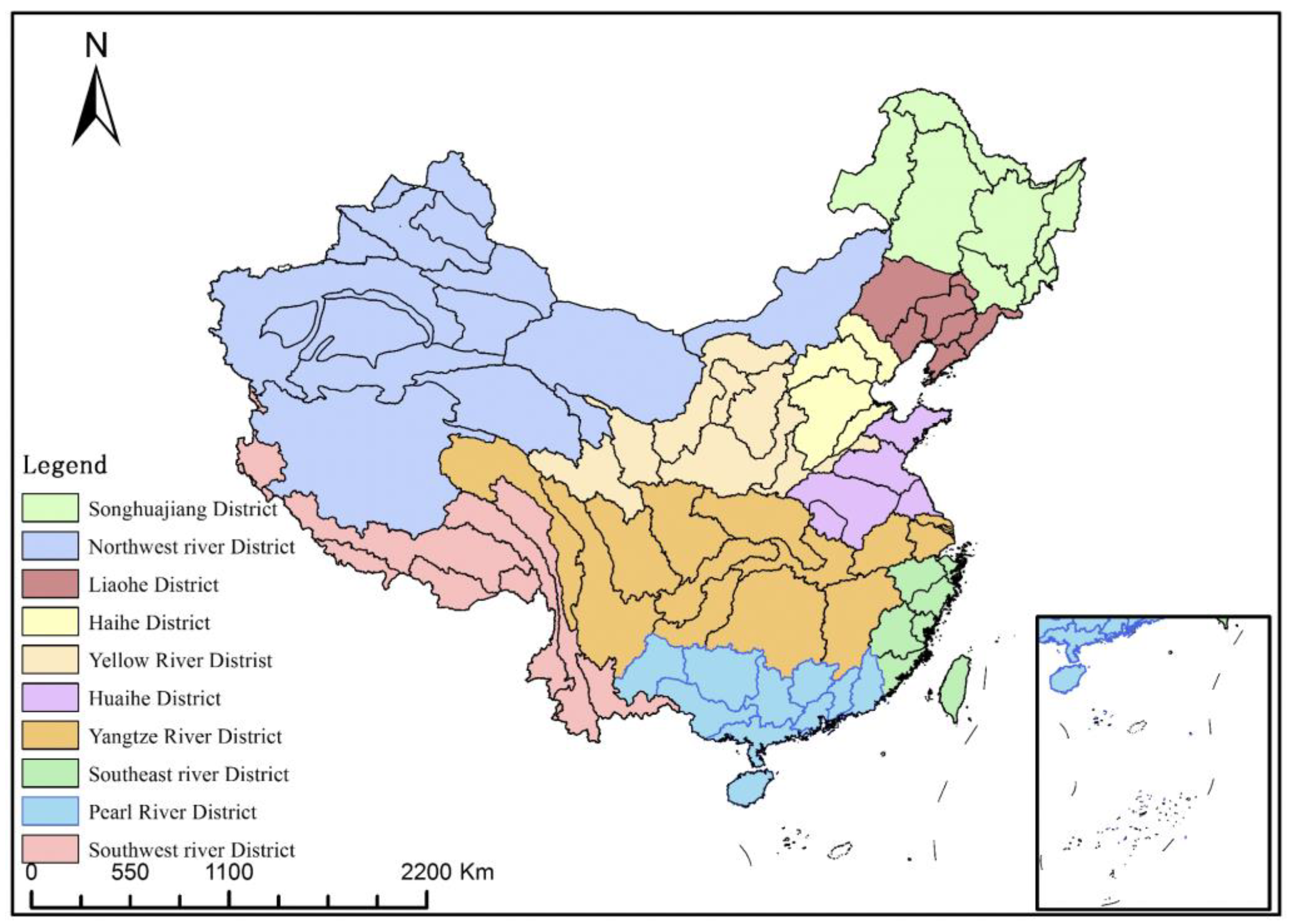
2.1. Study Area
2.1.1. Status of China’s Water Rights System
2.1.2. Selection of Study Units
2.2. Data Sources
2.3. Zoning of the Water Rights System
3. Results
4. Discussion
4.1. The Potential Impact of Inter-Basin Water Diversion
4.2. Possible Improvements to the Selection of Research Units and the Research Data
4.3. Objective Conditions and Social Selection of a Water Rights System
4.4. The Role of Water Pricing Systems
5. Conclusions
Author Contributions
Funding
Institutional Review Board Statement
Informed Consent Statement
Data Availability Statement
Conflicts of Interest
References
- Bruns, B. Reconstituting water rights: Pathways for polycentric praxis. In Proceedings of the Survival of the Commons: Mounting Challenges and New Realities, the Eleventh Conference of the International Association for the Study of Common Property, Bali, Indonesia, 19–23 June 2006; Volume 7, pp. 19–23. [Google Scholar]
- Schlager, E.; Ostrom, E. Property-rights regimes and natural resources: A conceptual analysis. Land Econ. 1992, 68, 249–262. [Google Scholar] [CrossRef]
- Sikor, T.; He, J.; Lestrelin, G. Property right regimes and natural resources: A conceptual analysis revisited. World Dev. 2017, 93, 337–349. [Google Scholar] [CrossRef]
- Wang, Y.; Wan, T.T.; Biswas, A.K. Structuring water rights in China: A hierarchical framework. Int. J. Water Resour. Dev. 2017, 34, 418–433. [Google Scholar] [CrossRef]
- Du, J.K.; Qiu, Y.Q.; Li, Y.L.; Lu, Q.; Hao, C.F.; Liu, H.Y. Evolution characteristics of the interannual and intra-annual precipitation in China from 1956 to 2016. Adv. Water Sci. 2023, 34, 182–196. [Google Scholar]
- Dai, D.; Alamanos, A.; Cai, W.; Sun, Q.; Ren, L. Assessing Water Sustainability in Northwest China: Analysis of Water Quantity, Water Quality, Socio-Economic Development and Policy Impacts. Sustainability 2023, 15, 11017. [Google Scholar] [CrossRef]
- Coase, R. Property Right and Institutional Change, Property Right School and New System School Translation Set; Shanghai People’s Publishing House: Shanghai, China, 1996. [Google Scholar]
- Lin, Y.F. China’s Economy Project; Peking University Press: Beijing, China, 2008. (In Chinese) [Google Scholar]
- Jia, S. China’s Water Right in Progress; China Water Power Press: Beijing, China, 2012. (In Chinese) [Google Scholar]
- Sun, Y.; Jia, S.; Jia, R. Classification and applicable conditions of water rights systems. Water Resour. Manag. 2023, 37, 4059–4073. [Google Scholar] [CrossRef]
- Li, Y.; Li, Y.; He, J. Strategic countermeasures for China’s water resources security in the new development stage. J. Hydraul. Eng. 2021, 52, 1340–1346. [Google Scholar]
- Jiang, Y. China’s water security: Current status, emerging challenges and future prospects. Environ. Sci. Policy 2015, 54, 106–125. [Google Scholar] [CrossRef]
- State Planning Commission of China, Ministry of Water Resources and Electric Power. Report on Distribution Scheme of Water Supply Capacity of the Yellow River[EB/OL]. (1987-09-11). Available online: http://www.gov.cn/zhengce/content/2011-03/30/content_3138.htm (accessed on 20 December 2019). (In Chinese)
- Li, X.T.; Zhang, X.D.; Wang, S.G. Managing conflicts and equitability in hierarchical decision making for water resources planning under fuzzy uncertainty: A case study of Yellow River, China. J. Hydrol. Reg. Stud. 2021, 38, 100963. [Google Scholar] [CrossRef]
- Lou, H.J.; Mao, R.Z.; Xia, J.; Feng, Y.F. The Study for Groundwater Resources System of China with Three-rated Appraising Method of Sub Area. Prog. Geogr. 2002, 21, 554–563. [Google Scholar]
- Jia, S.F.; Lv, A.F.; Han, Y.; Long, Q.B.; Zhu, W.B.; Yan, H.Y. China Water Security Report; Science Press: Beijing, China, 2014. (In Chinese) [Google Scholar]
- General Institute of Water Resources and Hydropower Planning and Design. Comprehensive National Water Resources Planning. 2009. Available online: http://www.360doc.com/document/16/0920/18/36074950_592315663.shtml (accessed on 23 May 2009). (In Chinese).
- General Institute of Water Resources and Hydropower Planning and Design. Investigation and Evaluation of Exploitation and Utilization of Water Resources in China; China Water Power Press: Beijing, China, 2008. (In Chinese) [Google Scholar]
- Zhao, X.; Zhang, H.; Li, T.; Ye, Z.; Xue, C.; Zhang, Y.; Yang, Z. Types identification and development tracking of urban water scarcity in China: A case study of 32 major cities. J. Nat. Resour. 2023, 38, 2619–2636. [Google Scholar] [CrossRef]
- Falkenmark, M.; Lundqvist, J.; Widstrand, C. Macro-scale water scarcity requires micro-scale approaches: Aspects of vulnerability in semi-arid development. In Natural Resources Forum; Blackwell Publishing Ltd.: Oxford, UK, 1989; Volume 13, pp. 258–267. [Google Scholar]
- Jia, X.X.; Yan, Y.; Zhu, C.Y.; Bai, X.; Hu, M.T.; Wu, G. Approaches for regional water resources stress assessment: A review. J. Nat. Resour. 2016, 31, 1783–1791. [Google Scholar]
- North, D.C. Institutions, Institutional Change, and Economic Performance; Shanghai People’s Publishing House: Shanghai, China, 1994. [Google Scholar]
- Zhang, M.; Yang, H.J.; Chen, H.L. Necessary and Precept of Inter-Basin Water Diversion to the Yellow River. Yellow River 2013, 35, 88–90. (In Chinese) [Google Scholar] [CrossRef]
- Liu, F.; Chen, C. Experiences and Implications of Water Price Formation Mechanisms in Typical Countries. Water Resour. Dev. Res. 2021, 12, 70–74. [Google Scholar]
- Shen, D.J.; Reddy, V.R. Water pricing in China and India: A comparative analysis. Water Policy 2016, 18, 103–121. [Google Scholar] [CrossRef]
- Moore, S.M. The development of water markets in China: Progress, peril, and prospects. Water Policy 2015, 17, 253–267. [Google Scholar] [CrossRef]
- Rosegrant, M.W.; Binswanger, H.P. Markets in tradable water rights: Potential for efficiency gains in developing country water resource allocation. World Dev. 1994, 22, 1613–1625. [Google Scholar] [CrossRef]


| Number | Names of the Second Class Zones | Average Annual Precipitation (mm) | Runoff Modulus (×104 m3/km2) | Basin Area (×104 km2) | Per capita Water Resources (m3/Person) | WUR (%) |
|---|---|---|---|---|---|---|
| 1 | Eerguna River | 444.55 | 8.30 | 15.71 | 6450.40 | 9.00 |
| 2 | Nen River | 535.45 | 12.30 | 29.43 | 2311.70 | 26.00 |
| 3 | The Second Songhua River | 775.72 | 24.70 | 7.40 | 1248.00 | 31.00 |
| 4 | Songhua River (Below Sanchakou) | 663.40 | 21.70 | 18.64 | 1766.80 | 32.00 |
| 5 | Heilongjiang Main River | 618.60 | 19.30 | 11.69 | 9334.00 | 10.00 |
| 6 | Wusuli River | 716.18 | 17.00 | 6.06 | 2191.00 | 83.00 |
| 7 | Suifen River | 720.27 | 15.80 | 1.03 | 2800.50 | 15.00 |
| 8 | Tumen River | 774.71 | 23.10 | 2.27 | 3211.50 | 10.00 |
| 9 | West Liao River | 473.15 | 5.20 | 13.56 | 952.30 | 61.00 |
| 10 | East Liao River | 621.31 | 12.40 | 1.02 | 570.90 | 45.00 |
| 11 | Liao Main River | 753.71 | 14.50 | 4.85 | 732.00 | 43.00 |
| 12 | Huitai River | 853.01 | 25.30 | 2.74 | 446.00 | 71.00 |
| 13 | Yalv River | 905.44 | 48.40 | 3.25 | 3807.90 | 6.00 |
| 14 | Rivers along the Yellow Sea and the Bohai Sea in Northeast China | 667.56 | 19.80 | 6.14 | 685.80 | 32.00 |
| 15 | Luan River and East Hebei coastal areas | 551.26 | 11.60 | 5.48 | 573.60 | 77.00 |
| 16 | North Hai Rivers | 481.98 | 10.70 | 8.29 | 246.30 | 87.00 |
| 17 | South Hai Rivers | 564.11 | 12.00 | 14.89 | 221.80 | 101.00 |
| 18 | Tuhaimajia River | 674.90 | 11.90 | 3.23 | 218.50 | 77.00 |
| 19 | Above Longyangxia | 597.52 | 15.80 | 13.18 | 32,393.50 | 1.00 |
| 20 | Longyangxia to Lanzhou | 441.27 | 14.70 | 9.08 | 1446.50 | 24.00 |
| 21 | Lanzhou to Hekou | 305.76 | 2.50 | 16.30 | 232.40 | 90.00 |
| 22 | Hekou to Longmen | 461.36 | 5.50 | 11.07 | 682.50 | 15.00 |
| 23 | Longmen to Sanmenxia | 582.69 | 8.20 | 19.16 | 301.50 | 45.00 |
| 24 | Sanmenxia to Huayuankou | 712.32 | 14.40 | 4.16 | 443.90 | 35.00 |
| 25 | Below Huayuankou | 671.23 | 15.50 | 2.30 | 266.20 | 69.00 |
| 26 | Inflow Area | 340.61 | 2.70 | 4.35 | 1604.50 | 50.00 |
| 27 | Up Reaches of Huai River | 1123.26 | 39.60 | 3.04 | 994.00 | 26.00 |
| 28 | Middle Reaches of Huai River | 1022.38 | 29.10 | 12.98 | 475.70 | 51.00 |
| 29 | Down Reaches of Huai River | 1207.49 | 30.40 | 3.14 | 551.70 | 33.00 |
| 30 | Yishusi River | 821.89 | 26.70 | 7.74 | 399.40 | 65.00 |
| 31 | Coastal Rivers along the Shandong Peninsula | 736.53 | 19.20 | 6.03 | 322.40 | 57.00 |
| 32 | Above Jinsha River Shigu | 628.21 | 19.30 | 21.64 | 53,741.40 | 54.00 |
| 33 | Below Jinsha River Shigu | 963.01 | 44.40 | 25.68 | 5140.60 | 5.00 |
| 34 | Mintuo River | 996.85 | 65.40 | 16.29 | 2835.70 | 17.00 |
| 35 | Jialing River | 971.65 | 43.90 | 15.92 | 1725.00 | 13.00 |
| 36 | Wu River | 1207.74 | 62.80 | 8.80 | 2615.50 | 10.00 |
| 37 | Yibin to Yichang | 1140.05 | 63.50 | 9.98 | 2052.70 | 6.00 |
| 38 | Rivers of Dongting Lake | 1434.99 | 79.50 | 26.20 | 2788.50 | 15.00 |
| 39 | Han River | 1018.33 | 37.00 | 15.54 | 1664.90 | 29.00 |
| 40 | Rivers of Panyang Lake | 1667.47 | 94.60 | 16.20 | 3679.00 | 12.00 |
| 41 | Yichang to Hukou | 1255.95 | 62.30 | 9.54 | 1685.10 | 6.00 |
| 42 | Main River below Hukou | 1386.47 | 55.20 | 8.94 | 1069.50 | 16.00 |
| 43 | Rivers of Tai Lake | 1388.75 | 48.10 | 3.68 | 309.30 | 17.00 |
| 44 | Qiantang River | 1726.77 | 93.60 | 4.94 | 2584.10 | 19.00 |
| 45 | Rivers in Eastern Zhejiang | 1629.85 | 82.60 | 1.14 | 1090.90 | 24.00 |
| 46 | Rivers in Southern Zhejiang | 1796.53 | 102.90 | 3.35 | 2139.20 | 13.00 |
| 47 | Rivers in Eastern Fujian | 1740.46 | 111.90 | 1.62 | 4880.30 | 11.00 |
| 48 | Min River | 1728.34 | 96.60 | 6.03 | 5594.00 | 14.00 |
| 49 | Minnan Rivers | 1683.36 | 87.40 | 3.45 | 1463.60 | 26.00 |
| 50 | Rivers of Taipengjinma | 1988.29 | 87.40 | 3.64 | 1463.60 | 26.00 |
| 51 | South and North Pan River | 1146.69 | 47.00 | 8.41 | 2397.10 | 13.00 |
| 52 | Hongliu River | 1405.74 | 80.00 | 11.33 | 6080.90 | 9.00 |
| 53 | Yu River | 1644.59 | 54.40 | 7.81 | 3148.90 | 18.00 |
| 54 | Xi River | 1743.54 | 87.70 | 6.63 | 3553.80 | 10.00 |
| 55 | Bei River | 1823.38 | 108.60 | 4.67 | 5544.40 | 11.00 |
| 56 | Dong River | 1909.51 | 100.50 | 2.78 | 2662.30 | 18.00 |
| 57 | Pearl River Delta | 2065.06 | 107.50 | 2.79 | 683.00 | 14.00 |
| 58 | Han River and Rivers in Eastern Guangdong | 1812.44 | 100.90 | 4.57 | 1949.60 | 17.00 |
| 59 | Coatal Rivers in Western Guangdong and Southern Guizhou | 2004.27 | 103.10 | 5.59 | 2429.40 | 20.00 |
| 60 | Rivers in Hainan island and the South China Sea islands | 1803.60 | 90.00 | 3.40 | 3535.80 | 15.00 |
| 61 | Hong River | 1297.76 | 61.00 | 7.59 | 6352.80 | 5.00 |
| 62 | Lancang River | 1126.20 | 45.10 | 16.51 | 10,887.80 | 4.00 |
| 63 | Nu River and Yiluowadi River | 1055.36 | 64.50 | 15.30 | 18,420.90 | 2.00 |
| 64 | Yaluzangbu River | 951.40 | 68.60 | 24.53 | 107,648.00 | 1.00 |
| 65 | Rivers in Southern Xizang | 1336.88 | 127.80 | 14.46 | 665,487.00 | 5.00 |
| 66 | Rivers in Western Xizang | 676.84 | 5.60 | 5.67 | 92,805.60 | 30.00 |
| 67 | Inland River in Inner Mongolian Plateau | 311.45 | 1.60 | 31.08 | 1299.50 | 31.00 |
| 68 | Inland River in Hexi Corridor | 133.56 | 1.50 | 46.94 | 1538.00 | 88.00 |
| 69 | Rivers in Qinghai Lake | 289.73 | 6.50 | 4.72 | 19,817.40 | 8.00 |
| 70 | Qaidam Basin | 145.40 | 2.10 | 27.46 | 12,794.60 | 25.00 |
| 71 | Rivers in Tuha Basin | 97.74 | 1.90 | 13.36 | 2097.40 | 89.00 |
| 72 | Rivers in Southern Aertai Mountain | 215.40 | 13.00 | 8.18 | 17,600.60 | 51.00 |
| 73 | Inland River in Central Asia and West Asia | 269.78 | 23.70 | 7.78 | 6597.10 | 42.00 |
| 74 | Guerbantonggute desert area | 179.16 | 20.00 | 8.51 | 1700.00 | 41.00 |
| 75 | Rivers in Northern Tian Mountain | 234.13 | 7.70 | 14.89 | 1704.40 | 79.00 |
| 76 | Headstream of Tarim River | 159.10 | 7.50 | 43.05 | 3299.20 | 77.00 |
| 77 | Rivers in Northern Kunlun Mountain | 89.54 | 2.50 | 19.66 | 9193.90 | 30.00 |
| 78 | Mainstream of Tarim River | 85.13 | 0.10 | 3.16 | 151.10 | 10.00 |
| 79 | Desert area in Tarim Basin | 67.80 | 3.10 | 34.50 | 132.00 | 9.00 |
| 80 | Inland Rivers in Qiangtang Plateau | 297.71 | 3.70 | 73.22 | 113,680.00 | 11.00 |
| Number | Names of the Second Class Zones | The Suitable Water Rights System |
|---|---|---|
| 1 | Eerguna River | Quantity proportion water rights |
| 2 | Nen River | Quantity proportion water rights |
| 3 | The second songhua river | Quantity proportion water rights |
| 4 | Songhua River (Below Sanchakou) | Quantity proportion water rights |
| 5 | Heilongjiang Main River | Quantity proportion water rights |
| 6 | Wusuli River | Quantity proportion water rights |
| 7 | Suifen River | Riparian rights |
| 8 | Tumen River | Riparian rights |
| 9 | West Liao River | Quantity proportion water rights |
| 10 | East Liao River | Quantity proportion water rights |
| 11 | Liao Main River | Quantity proportion water rights |
| 12 | Huitai River | Quantity proportion water rights |
| 13 | Yalv River | Riparian rights |
| 14 | Rivers along the Yellow Sea and the Bohai Sea in Northeast China | Quantity proportion water rights |
| 15 | Luan River and East Hebei coastal areas | Quantity proportion water rights |
| 16 | North Hai Rivers | Quantity proportion water rights |
| 17 | South Hai Rivers | Quantity proportion water rights |
| 18 | Tuhaimajia River | Quantity proportion water rights |
| 19 | Above Longyangxia | Quantity proportion water rights |
| 20 | Longyangxia to Lanzhou | Quantity proportion water rights |
| 21 | Lanzhou to Hekou | Quantity proportion water rights |
| 22 | Hekou to Longmen | Quantity proportion water rights |
| 23 | Longmen to Sanmenxia | Quantity proportion water rights |
| 24 | Sanmenxia to Huayuankou | Quantity proportion water rights |
| 25 | Below Huayuankou | Quantity proportion water rights |
| 26 | Inflow Area | Quantity proportion water rights |
| 27 | Up Reaches of Huai River | Quantity proportion water rights |
| 28 | Middle Reaches of Huai River | Quantity proportion water rights |
| 29 | Down Reaches of Huai River | Quantity proportion water rights |
| 30 | Yishusi River | Quantity proportion water rights |
| 31 | Coastal Rivers along the Shandong Peninsula | Quantity proportion water rights |
| 32 | Above Jinsha River Shigu | Quantity proportion water rights |
| 33 | Below Jinsha River Shigu | Riparian rights |
| 34 | Mintuo River | Riparian rights |
| 35 | Jialing River | Riparian rights |
| 36 | Wu River | Riparian rights |
| 37 | Yibin to Yichang | Riparian rights |
| 38 | Rivers of Dongting Lake | Riparian rights |
| 39 | Han River | Quantity proportion water rights |
| 40 | Rivers of Panyang Lake | Riparian rights |
| 41 | Yichang to Hukou | Riparian rights |
| 42 | Main River below Hukou | Quantity proportion water rights |
| 43 | Rivers of Tai Lake | Quantity proportion water rights |
| 44 | Qiantang River | Riparian rights |
| 45 | Rivers in Eastern Zhejiang | Quantity proportion water rights |
| 46 | Rivers in Southern Zhejiang | Riparian rights |
| 47 | Rivers in Eastern Fujian | Riparian rights |
| 48 | Min River | Riparian rights |
| 49 | Minnan Rivers | Quantity proportion water rights |
| 50 | Rivers of Taipengjinma | Quantity proportion water rights |
| 51 | South and North Pan River | Riparian rights |
| 52 | Hongliu River | Riparian rights |
| 53 | Yu River | Riparian rights |
| 54 | Xi River | Riparian rights |
| 55 | Bei River | Riparian rights |
| 56 | Dong River | Riparian rights |
| 57 | Pearl River Delta | Quantity proportion water rights |
| 58 | Han River and Rivers in Eastern Guangdong | Riparian rights |
| 59 | Coatal Rivers in Western Guangdong and Southern Guizhou | Riparian rights |
| 60 | Rivers in Hainan island and the South China Sea islands | Riparian rights |
| 61 | Hong River | Riparian rights |
| 62 | Lancang River | Riparian rights |
| 63 | Nu River and Yiluowadi River | Riparian rights |
| 64 | Yaluzangbu River | Riparian rights |
| 65 | Rivers in Southern Xizang | Riparian rights |
| 66 | Rivers in Western Xizang | Quantity proportion water rights |
| 67 | Inland River in Inner Mongolian Plateau | Quantity proportion water rights |
| 68 | Inland River in Hexi Corridor | Quantity proportion water rights |
| 69 | Rivers in Qinghai Lake | Quantity proportion water rights |
| 70 | Qaidam Basin | Quantity proportion water rights |
| 71 | Rivers in Tuha Basin | Quantity proportion water rights |
| 72 | Rivers in Southern Aertai Mountain | Quantity proportion water rights |
| 73 | Inland River in Central Asia and West Asia | Quantity proportion water rights |
| 74 | Guerbantonggute desert area | Quantity proportion water rights |
| 75 | Rivers in Northern Tian Mountain | Quantity proportion water rights |
| 76 | Headstream of Tarim River | Quantity proportion water rights |
| 77 | Rivers in Northern Kunlun Mountain | Quantity proportion water rights |
| 78 | Mainstream of Tarim River | Quantity proportion water rights |
| 79 | Desert area in Tarim Basin | Quantity proportion water rights |
| 80 | Inland Rivers in Qiangtang Plateau | Quantity proportion water rights |
Disclaimer/Publisher’s Note: The statements, opinions and data contained in all publications are solely those of the individual author(s) and contributor(s) and not of MDPI and/or the editor(s). MDPI and/or the editor(s) disclaim responsibility for any injury to people or property resulting from any ideas, methods, instructions or products referred to in the content. |
© 2023 by the authors. Licensee MDPI, Basel, Switzerland. This article is an open access article distributed under the terms and conditions of the Creative Commons Attribution (CC BY) license (https://creativecommons.org/licenses/by/4.0/).
Share and Cite
Sun, Y.; Jia, S.; Jia, R.; Svensson, J.; Lv, A.; Zhu, W.; Liu, J. Types of Water Rights Systems in China: A Zoning Scheme Applied. Sustainability 2023, 15, 16504. https://doi.org/10.3390/su152316504
Sun Y, Jia S, Jia R, Svensson J, Lv A, Zhu W, Liu J. Types of Water Rights Systems in China: A Zoning Scheme Applied. Sustainability. 2023; 15(23):16504. https://doi.org/10.3390/su152316504
Chicago/Turabian StyleSun, Yuanyuan, Shaofeng Jia, Ru Jia, Jesper Svensson, Aifeng Lv, Wenbin Zhu, and Jianxu Liu. 2023. "Types of Water Rights Systems in China: A Zoning Scheme Applied" Sustainability 15, no. 23: 16504. https://doi.org/10.3390/su152316504
APA StyleSun, Y., Jia, S., Jia, R., Svensson, J., Lv, A., Zhu, W., & Liu, J. (2023). Types of Water Rights Systems in China: A Zoning Scheme Applied. Sustainability, 15(23), 16504. https://doi.org/10.3390/su152316504