Article

Identification of the Pollution Mechanisms and Remediation Strategies for Abandoned Wells in the Karst Areas of Northern China

1
Key Laboratory of Groundwater Resources and Environment, Ministry of Education, Jilin University, Changchun 130021, China
2
Jilin Provincial Key Laboratory of Water Resources and Environment, Jilin University, Changchun 130021, China
3
College of New Energy and Environment, Jilin University, Changchun 130021, China
4
Center for Hydrogeology and Environmental Geology Survey, CGS, Baoding 071051, China
5
The Third Geological Exploration Institute of China Metallurgical Geology Bureau, Taiyuan 450016, China
6
Hebei Province Collaborative Innovation Center for Sustainable Utilization of Water Resources and Optimization of Industrial Structure, School of Water Resources and Environment, Hebei GEO University, Shijiazhuang 050031, China
*
Author to whom correspondence should be addressed.
Sustainability 2023, 15(23), 16458; https://doi.org/10.3390/su152316458
Submission received: 11 October 2023 / Revised: 21 November 2023 / Accepted: 27 November 2023 / Published: 30 November 2023
(This article belongs to the Special Issue Sustainable Water and Environmental Systems)

Abstract

:
Abandoned well pollution is a critical component of global environmental issues and a historical legacy issue of national development. Despite this, the specific mechanisms by which abandoned wells pollute groundwater remain unclear, particularly in the karst regions of Northern China, where no scientifically effective remediation methods exist. To address this gap, this study focuses on Yangquan City in Shanxi Province and employs field investigations, the analytic hierarchy process, high-definition deep-well logging technology, and qualitative analysis to assess the pollution risk of all abandoned wells in the study area, identifying those with high pollution risk. Through the analysis of extensive image and video data for these high-risk wells, we propose a conceptual model of cross-strata channels in abandoned wells and elucidate the mechanisms by which they pollute groundwater. The results show that, from a single-well perspective, the pollution mechanism is cross-strata pollution. From a regional perspective, the pollution mechanisms are hydraulic connectivity and solute migration and transformation. Based on these findings, we present a scientifically effective remediation strategy tailored to the typical characteristics of abandoned wells in the study area, offering a viable solution to the abandoned well pollution problem in Yangquan City. This research not only augments the theoretical framework in the domain of groundwater pollution but also advances sustainable groundwater security and management strategies. Moreover, the study furnishes theoretical foundations and pragmatic solutions for the remediation of abandoned wells in Yangquan City, which are crucial for the sustainability of the groundwater ecosystem.

1. Introduction

The sustainability of underground resources directly impacts economic and social development [1]. With rapid population growth, the exploration and exploitation of underground resources have accelerated [2,3,4], leading to the emergence of numerous wells, such as drilling wells, water extraction wells, coal field wells, oil wells, natural gas wells, and geothermal wells. After long-term usage, the structural integrity of these wells and their casings is compromised, or they must be closed due to reaching their lifespan [5]. This leads to an array of diverse abandoned wells, posing significant threats to the sustainability of the subterranean environment [6]. Pollution and remediation issues concerning abandoned wells have also become a critical environmental issue among global historical legacies [7].
Abandoned wells are wells that have been discontinued or are no longer usable for various reasons; these can include oil, gas, and water wells, among others. Abandoned well remediation involves using effective methods to prevent contamination of the underground environment. These methods aim to prevent pollution sources from seeping through abandoned wells. Several types of abandoned wells exist, including coal mine abandoned wells [8,9], oil field abandoned wells [10], coal mine gas (natural gas) abandoned wells [11,12,13], geothermal abandoned wells [14,15], and abandoned water wells [6,16,17]. The primary aim of remediation for abandoned coal mine wells is to sever the hydraulic link between acid mine drainage and other aquifers, thereby preventing cross-layer pollution [18]. The primary aim of remediation for abandoned oil field wells is to prevent accidents—such as leakage, wellhead loss of control, and blowouts—that could cause environmental pollution. The current main remediation method is to use cement slurry for plugging [19]. Research on these abandoned wells has focused on the fields of cementing technology, well control safety disposal technology, segmented well sealing technology, and numerical simulation technology [20,21]. On the other hand, abandoned natural gas wells slightly differ, with the majority being transformed from depleted oil wells [22]. Remediation methods for natural gas abandoned wells include the ultra-fine cement grouting method [22] and micro-gel water plugging technology [23]. Geothermal abandoned wells are also transformed from abandoned oil field wells [24], and research on the remediation of this type of abandoned well mainly focuses on the remodeling process and the process of water shut-off in abandoned wells [25].
Overall, research on cross-strata pollution issues related to abandoned wells is relatively scarce in the groundwater pollution field. Existing studies mainly focus on abandoned wells with clear sources of pollution, whereas research regarding groundwater pollution caused by abandoned water wells and the remediation of such pollution is comparatively limited. This is primarily because abandoned water wells often do not have clear sources of pollution, and thus tend to be overlooked in research. However, in karst regions with complex geological conditions and multiple sources of pollution, like Yangquan City in Shanxi Province, abandoned wells provide channels for cross-strata pollution, posing serious threats to groundwater safety. In such geological contexts, investigating the mechanisms of cross-strata pollution in abandoned wells becomes critically imperative to furnishing scientific foundations and technical support for the sustainable development of groundwater resources and the remediation of abandoned wells.
This study focuses on Yangquan City as the study area and analyzes the video and image data of abandoned wells with high pollution risks. It identifies the cross-strata pollution channels of abandoned wells and uncovers the pollution mechanisms of abandoned wells affecting groundwater. Based on these findings, a remediation method is proposed for different types of abandoned wells in the study area, effectively addressing the abandoned well pollution problem in Yangquan City. This study carries significant practical value for enhancing the sustainable exploitation and utilization of groundwater, as well as for the mitigation and management of groundwater pollution in Yangquan City. Furthermore, it acts as an exemplar and guideline for the remediation of abandoned wells in other similar areas within Shanxi Province and globally.

2. Materials and Methods
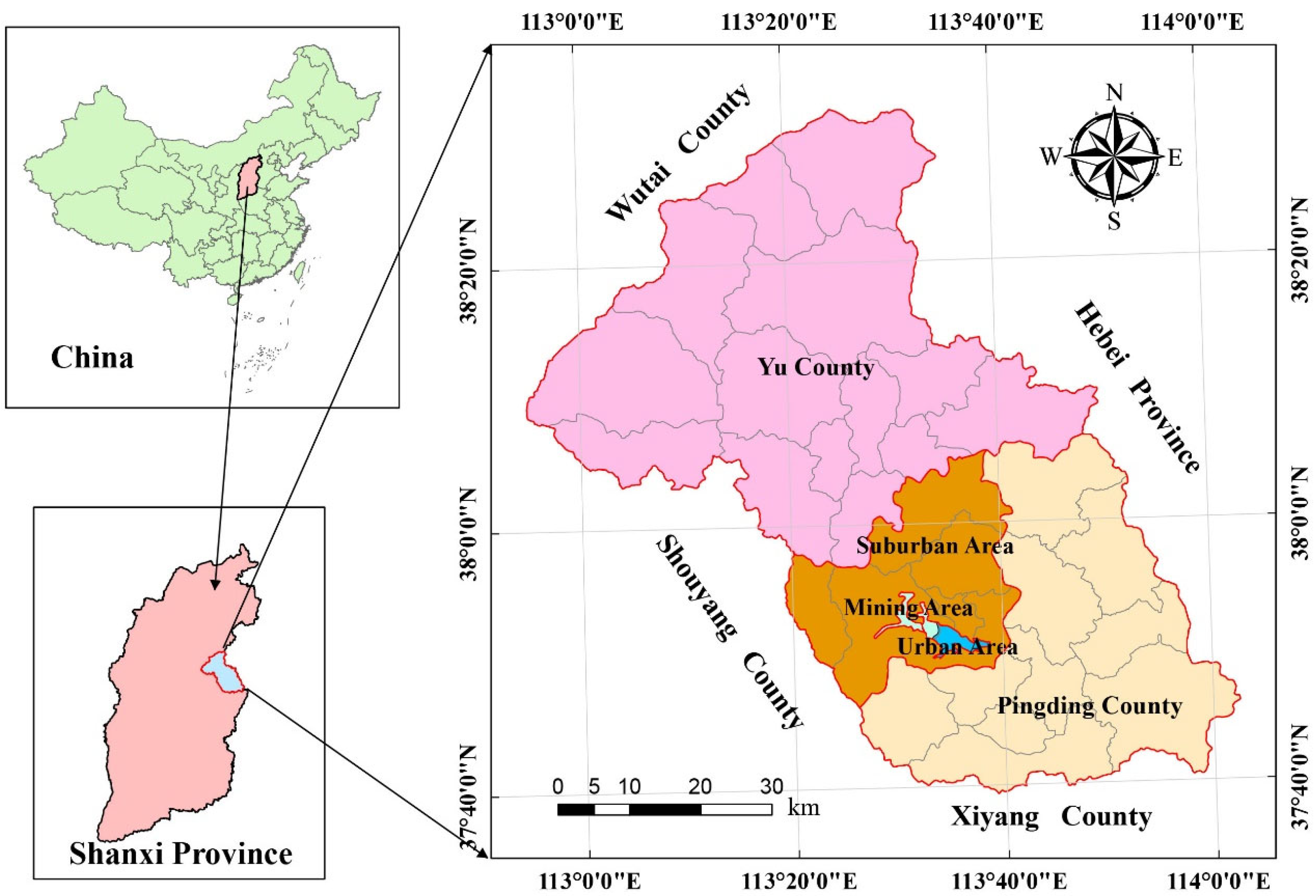
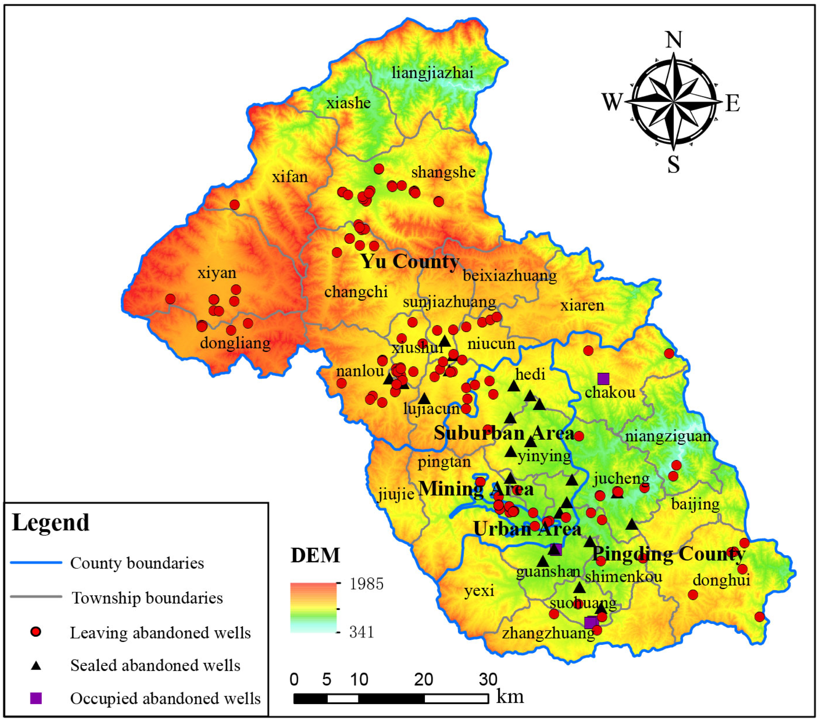
2.1. Study Area

Yangquan City is an emerging industrial city located on the eastern side of central Shanxi Province. Geographically, it lies between 37°40′ N to 38°31′ N latitude and 112°54′ E to 114°03′ E longitude (Figure 1). The city stretches approximately 106 km from north to south and is about 42 km wide from east to west. Yangquan City has a total area of 4558.93 km2, accounting for 3% of the total area of Shanxi Province [26]. The city is divided into two counties and three districts: Pingding County, Yu County, the urban area, the mining area, and the suburban area, with respective areas of 1390.94 km2, 2514.38 km2, 14.77 km2, 11.83 km2, and 627.01 km2. Yangquan City has a warm temperate continental monsoon climate with four distinct seasons. The multi-year average temperature is 11.3 °C, and the multi-year average rainfall is 513.46 mm.
The topography of Yangquan City is predominantly mountainous and belongs to a typical mid-low mountainous region. Its area is 3362.1 km2, accounting for 73.75% of the city’s total area. The overall terrain is higher in the northwest and lower in the southeast, with DEM (Digital Elevation Model) values ranging between 341 and 1985 m. The hydrogeological conditions in the study area are relatively complex. Considering the lithological properties of aquifer media and groundwater occurrence characteristics, the aquifers in the study area can be categorized into five primary types: unconsolidated rock porous aquifers, clastic rock fissure aquifers, clastic rock intercalated with carbonate rock karst-fissure aquifers, carbonate rock karst aquifers, and metamorphic rock basalt fissure aquifers (Supplementary Figure S1). The primary water supply for industrial activities and urban life in Yangquan City comes from the karst groundwater in the Niangziguan spring area [27], making up 70% of the city’s total water usage [28]. However, due to climate change (such as reduced rainfall, increased temperature, and enhanced evaporation) and human activities (like extensive groundwater extraction and coal mining drainage), the spring flow is gradually declining [29,30,31].

Abandoned Wells

In 2021, a comprehensive survey was conducted on abandoned wells in Yangquan City. The survey revealed that there are a total of 165 abandoned water wells in the city, of which 28 have been sealed or occupied due to road construction or factory buildings, leaving 137 remaining abandoned water wells. Among these, 10 are in the urban area, 5 in the suburban area, 18 in the mining area, 80 in Yu County, and 24 in Pingding County, with respective proportions of 7%, 4%, 13%, 58%, and 18% (Figure 2). The survey found that Yangquan City had not implemented unified management for abandoned wells, and no actions had been taken after the wells were decommissioned. This poses a serious threat to groundwater safety.

2.2. Research Methodology

2.2.1. Field Investigation and Site Inspection

Field investigations and site inspections are common field research methods primarily used in the fields of geology, hydrogeology, and environmental science. This approach requires researchers to personally visit the study area for on-site investigations and surveys to obtain accurate and detailed data and information. In this study, such data mainly include the specific locations of abandoned wells, well diameters, abandonment times, and reasons for abandonment, as well as surrounding traffic conditions and environmental pollution status. This research method gathers first-hand data through inquiries, observations, measurements, and recordings, helping researchers gain a deep understanding of the actual conditions in the study area and providing a data foundation for subsequent research work.

2.2.2. High-Definition Deep Well Logging Technology (HDWLT)

HDWLT is a high-precision measurement technology that directly obtains underground images and video data [32,33]. It has the advantages of intuitiveness, accuracy, and real-time capabilities and has broad application prospects in the detection of abandoned wells [34]. The equipment mainly consists of three parts: the underground system, logging cable, and ground control platform [32]. Through a 360-degree rotatable high-definition camera, the internal structure and damage conditions of abandoned wells can be clearly and accurately observed. This includes the material of the well casing, the degree and location of corrosion and damage to the well casing, the diameter of the well casing, leakage conditions, the location of the filter pipe, the well depth, and the fill material at the bottom of the well. By conducting these inspections, quantitative baseline data on abandoned wells in the study area can be obtained, providing a scientific basis for subsequent assessment and remediation work on abandoned wells.

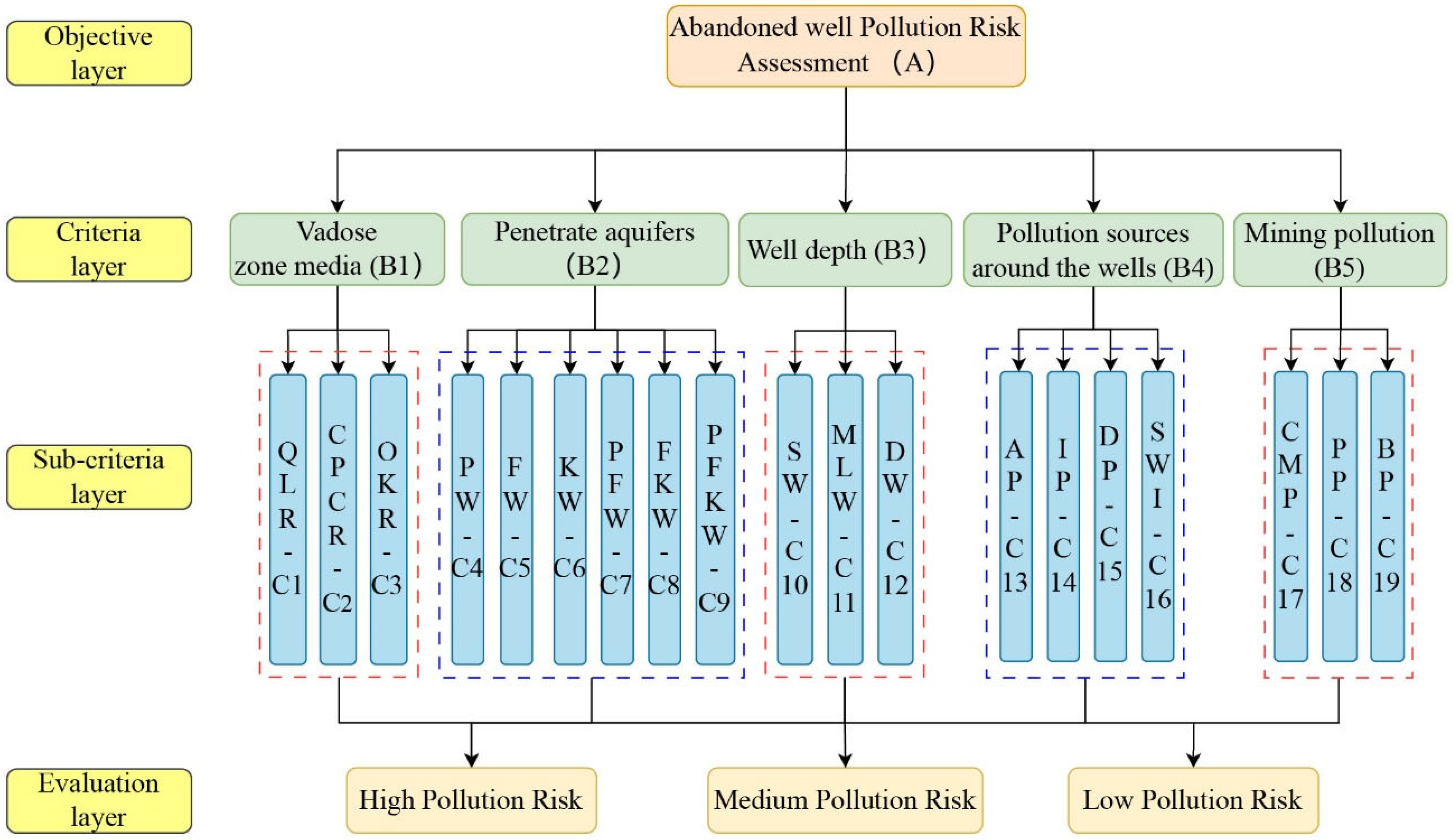
2.2.3. Analytic Hierarchy Process

The Analytic Hierarchy Process (AHP), proposed by Saaty [35], is a method used to solve complex decision-making problems. AHP is a structured technique [36], the core idea of which is to break down a complex problem into multiple hierarchical sub-problems and make the best decision using a combination of quantitative and qualitative methods [37,38]. This method has the advantages of a clear structure, easy operation, and wide applicability [39]. It has been extensively applied in the fields of ecology, environment, and groundwater [40,41,42], such as environmental risk assessment [43,44,45], groundwater pollution risk assessment [38], groundwater potential assessment [46,47,48], and groundwater vulnerability assessment [49,50,51].
The primary steps of AHP are as follows [52,53]:
(1)
Construct a hierarchical structural model. Decompose the complex problem into the objective layer, criteria layer, sub-criteria layer, and assessment layer.
(2)
Establish a pairwise comparison matrix. Create a pairwise comparison matrix by comparing the importance of two factors. The 1–9 scale method is generally used (Table 1).
(3)
Calculate the consistency rate (CR) [55]. Primarily for the purpose of testing the rationality of the comparison matrix. The calculation formula is as follows:
C I = λ m a x n n 1
C R = C I R I
where CI is the consistency index [56]. The larger the CI value, the worse the consistency of the comparison matrix, and vice versa [57]. When the CI value is 0, the comparison matrix has complete consistency. λmax is the maximum eigenvalue, n is the order, RI is the average random consistency index (Table 2), and CR is the consistency ratio of the comparison matrix. When CR < 0.1, it indicates that the comparison matrix has good consistency. Otherwise, the matrix needs to be readjusted.
(4)
Weight Calculation. In this work, Python was used to calculate the index weight in the AHP.
(5)
Calculate the synthesis score. The comprehensive score for each evaluation object was calculated using the weight and score values of each indicator, based on which an assessment was made. The calculation formula is as follows:
Q = i = 1 n W i × R i    
where Q is the comprehensive evaluation index, Wi represents the weight of each indicator, Ri represents the score of each indicator, and i is the number of indicators.

3. Results and Discussion

3.1. Abandoned Well Pollution Risk Assessment

3.1.1. Abandoned Well Pollution Risk Hierarchical Model

Through literature analysis, field investigations, and consultations with experts, criteria and sub-criteria layers for the risk assessment of abandoned well pollution are determined, and a hierarchical model is constructed. In this work, the hierarchical model consists of 4 layers, including the objective layer, criteria layer, sub-criteria layer, and evaluation layer (Figure 3).
The criteria layer mainly includes:
(1)
Vadose zone media, which determines the infiltration potential of surface water and the vertical migration ability of pollutants, as well as possible chemical reactions that may occur [46,58,59]. Pollutants infiltrating the vadose zone can enter underground through abandoned well channels and cause groundwater pollution.
(2)
Abandoned wells penetrate aquifers, and the wellbore penetrates through various geological layers and aquifers. The pollution risk is different for different aquifers. It can also be determined whether the abandoned wells penetrate a single water layer or multiple water layers and whether there is a risk of cross-layer contamination.
(3)
Abandoned well depth is an important parameter determining the ability of pollutants to reach specific aquifers [38,60]. Abandoned wells serve as channels communicating pollutants between the source and the groundwater bodies; the deeper the well, the more aquifer layers it communicates with, and the higher the risk of cross-layer contamination.
(4)
Pollution sources around the abandoned wells and the environmental surroundings of the abandoned wells have a significant impact on groundwater pollution. Pollutants can enter the ground directly through the channels of abandoned wells, causing groundwater contamination.
(5)
Mining pollution: Yangquan City is rich in mineral resources, and pollutants generated during mining, as well as mine pit wastewater formed after mine closure and filled by groundwater, can enter the ground through the channels of abandoned wells, polluting the groundwater environment.
Other layers are shown in Figure 3.

3.1.2. Pairwise Comparison Matrix and Weight Calculation

In this work, according to the preferences and importance of pairwise factors in the hierarchical model, pairwise comparison matrices are constructed, and weight values are calculated. The pairwise comparison matrices and weight results of the criteria layer and sub-criteria layer are as follows (Table 3, Table 4, Table 5, Table 6, Table 7 and Table 8):
In summary, the consistency ratio values of all pairwise comparison matrices are less than 0.1, showing good consistency test results [55].
Based on the weights of criteria and sub-criteria, along with the scores of sub-criteria, the comprehensive scores are calculated for individual abandoned wells, as detailed in Table 9 and Supplementary Table S1. A higher comprehensive score signifies a greater risk of groundwater pollution attributed to a given abandoned well. The abandoned wells are categorized as posing a low pollution risk with a comprehensive score within the 0–1 range; those are considered to present medium pollution risk with scores between 1 and 2, while those are classified as high pollution risk with scores exceeding 2.

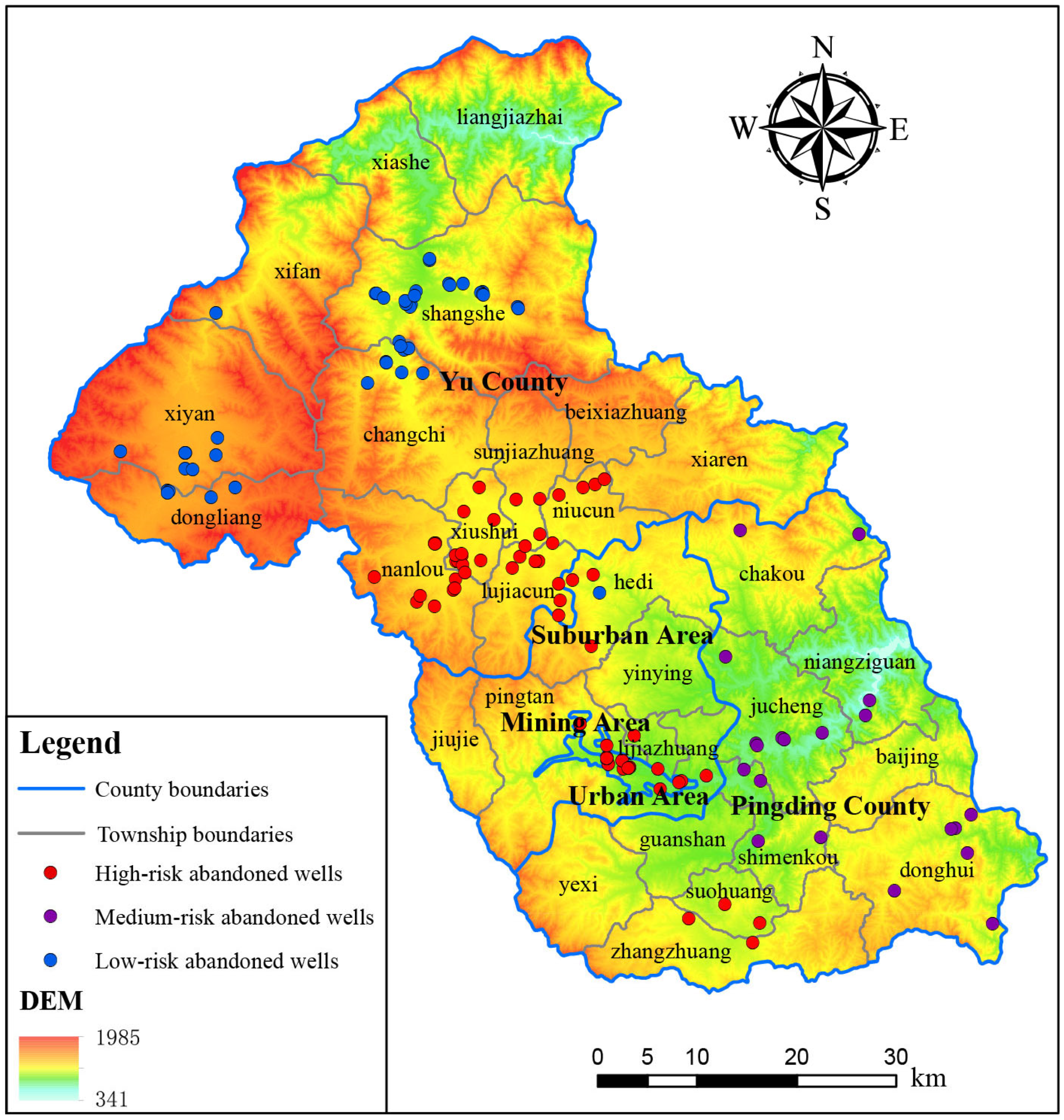
3.1.3. Abandoned Well Pollution Risk Assessment

Figure 4 delineates the spatial distribution of abandoned wells categorized by risk levels within Yangquan City. A total of 44 low-risk wells, constituting 32.12% of the overall count, are predominantly located in the northern sector of the city. These wells are relatively shallow, with depths generally ranging from several tens to over a hundred meters, and they are primarily utilized for the extraction of Quaternary porous water. And these wells are located in agricultural zones with low population density and minimal anthropogenic pollution sources. In addition, these abandoned wells penetrate only a single aquifer and do not contact deeper aquifers, so the risk of groundwater pollution from abandoned wells in this area is low.
A total of 20 medium-risk abandoned wells, constituting 14.6% of the overall count, are predominantly located in the eastern region of Yangquan City, characterized by exposure to Ordovician limestone. The depths of these wells are approximately 200–600 m and are primarily used for extracting Ordovician karst water. The upper Ordovician Fengfeng Formation has limited water content and serves as a weakly permeable layer, with gypsum present at the bottom. The primary sources of pollution in this area stem from the infiltration of domestic wastewater and surface water. These wells penetrate the gypsum layer, presenting a risk of contaminant migration through the well channels into underground aquifers.
A total of 73 high-risk abandoned wells, constituting 53.28% of the overall count, are predominantly located in the central region of Yangquan City. The geological strata in this area are complex, encompassing Quaternary, Permian, Carboniferous, and Ordovician formations. Additionally, the Shanxi and Taiyuan formations are rich in coal seams. The depths of these abandoned wells generally exceed 600 m and are mainly used for extracting subterranean karst water. These wells penetrate multiple geological layers and aquifers, thereby posing a high risk of cross-strata pollution. The area is densely populated and hosts a wide range of industrial and mining enterprises, contributing to multiple sources of pollution. Moreover, this region is upstream in the groundwater flow, allowing various pollutants to enter the aquifers through the abandoned well channels, thereby elevating the risk of groundwater pollution.
The spatial distribution of these three risk categories of abandoned wells demonstrates significant independence and regional characteristics without any overlapping occurrences. This distribution pattern is largely driven by the specific geological conditions and characteristics of the abandoned wells in Yangquan City. Although the subjectivity of the Analytic Hierarchy Process (AHP) may have some influence, the evaluation results are consistent with the actual conditions in Yangquan City [61]. The results of the risk assessment of abandoned wells have laid the foundation for the study of the mechanisms and remediation of abandoned well pollution.

3.2. Abandoned Well Pollution Channel and Mechanism

All high-pollution-risk abandoned wells were detected using HDWLT. It was found that the well casing wall of the abandoned wells had undergone severe corrosion (Figure 5a), and the well casing perforation was significant (Figure 5b). Additionally, it was also clearly observed that groundwater cross-strata occurred in the abandoned wells (Figure 5c,d).

3.2.1. Single-Well Cross-Strata Pollution Channel

In the present study, we employed HDWLT to acquire extensive multimedia data, encompassing images and videos, from high-risk abandoned wells. Through an integrative analysis of these fundamental data sets, the principal pollution channels were identified within Yangquan City’s abandoned wells. Based on the above analysis and the characteristics of high-risk abandoned wells, a “conceptual model for a single-well cross-strata channel” is introduced (Figure 6a). This conceptual model is composed of three key channels.
(1)
Wellhead Channel: The wellhead is the direct pollution channel for abandoned wells [62]. Owing to its exposure to surface conditions, it facilitates the unimpeded entry of pollutants into the subsurface aquifer, thereby compromising groundwater quality. This is a critical pollution channel for abandoned wells.
(2)
Well Casing Wall Channel: These channels were formed due to the corrosion and deterioration of the wellbore walls and belong to internal channels. Such channels emerge due to complex interactions between the wellbore and the surrounding geochemical environment, including groundwater chemistry and the chemical properties of adjacent rock formations. The formation of these channels is influenced by factors like the well’s operational lifespan, the quality of wellbore materials, and the chemical properties of the groundwater. The location, number, and size of these channels exhibit significant uncertainty. However, over time, the number of channels increases, and the corrosion pores enlarge, facilitating the ingress of pollutants from the surface or upper aquifers, thereby accelerating the groundwater pollution process.
(3)
Annular Space Channel: These channels were formed by the gap between the wellbore wall and the adjacent strata. This is a unique type of pollution channel primarily associated with well-constructed construction techniques and quality. These channels mainly form due to outdated drilling technology that did not include wellbore stabilization, creating an annular space between the wellbore wall and the native rock strata. This space may expand due to improper well use and maintenance, such as excessive water extraction and corrosion of wellbore materials, thereby evolving into significant channels for groundwater pollution. These channels are highly concealed and often overlooked in the general remediation processes for abandoned wells.
The three channels establish hydraulic connectivity between the upper and lower aquifers, as well as surface water bodies, thereby causing cross-strata pollution between different aquifers. Therefore, these channels can also be designated as abandoned well cross-strata pollution channels. Meanwhile, these channels also alter the recharge and discharge conditions of surface water and upper aquifers, intensifying local recharge where abandoned wells are present, increasing runoff velocity, and reducing discharge. This results in deep karst aquifers receiving water replenishment while also becoming polluted by external water sources [63].

3.2.2. Group-Well Cross-Strata Pollution Channel

To study the implications of abandoned wells on regional groundwater pollution, a “conceptual model for group-well cross-strata channel” is introduced. This model not only retains the salient features of the existing “conceptual model for a single-well cross-strata channel” but also considers the cumulative impact of low-risk and medium-risk abandoned wells, as well as other high-risk abandoned wells. As illustrated in Figure 6b, ‘Type A’ denotes low-risk abandoned wells that predominantly penetrate Quaternary unconsolidated porous aquifers. ‘Type B’ signifies medium-risk abandoned wells that primarily penetrate Permian-Carboniferous clastic fractured aquifers. ‘Type C’ designates high-risk abandoned wells that mainly penetrate the lower Ordovician carbonate aquifers.
Within a region, abandoned wells of different risk levels are interconnected through cross-strata channels, aquifers, and well screens, thereby establishing a complex, interconnected three-dimensional network system of group-well cross-strata channels. This network system not only connects abandoned wells of different risk levels but also links aquifers of different types. In this network system, the well screens and aquifers serve as bridges connecting different abandoned well channels, tightly linking all abandoned wells together. This leads to the issue of cross-strata in the groundwater flow process among different aquifers, thereby increasing the risk of groundwater pollution.
In accordance with the theory of groundwater flow systems (Figure 6b), groundwater in porous aquifers flows into Type A wells through the well screen and into Type B and C wells via the well casing wall channel and annular space channel. Subsequently, the groundwater in porous aquifers passes through the well screens of Type B and C wells to enter the fractured and karst aquifers. Similarly, groundwater in fractured aquifers can flow into other Type B and C wells in a similar manner, thereby entering the karst aquifers and resulting in the issue of groundwater cross-strata. This intricate three-dimensional group-well cross-strata channel network system significantly enhances the risk and complexity of regional groundwater pollution. Once a pollutant source is introduced, it inevitably imposes long-term and extensive impacts on the groundwater system.

3.2.3. Abandoned Well Pollution Mechanism

Investigations have revealed that abandoned wells have caused pollution in the karst aquifer. The main manifestations are: (1) Well casing wall corrosion, as illustrated in Figure 5a, has led to a significant exceedance of iron ions in groundwater. (2) In the study area, the Carboniferous strata, which encompass coal seams, pyrite, and gypsum, contribute to the deterioration of water quality. These inferior waters can infiltrate the karst aquifer through the channels of abandoned wells, resulting in pollution (Figure 5c,d). (3) Mining activities in the Shandi River basin of Yangquan city have led to the discharge of abandoned mine water. A portion of this water emerges, causing river contamination, while the remainder can infiltrate the karst aquifer through abandoned wells, leading to further pollution. (4) Pollution of surface water caused by industrial, agricultural, and domestic activities, wherein these wastewaters penetrate the subsurface and directly contaminate the karst water via the wellhead channels and annular space of abandoned wells. Therefore, identifying the pollution mechanisms of abandoned wells in groundwater is of paramount importance.
From a single-well perspective, the mechanism of groundwater pollution through abandoned wells is as follows: abandoned wells provide a cross-strata channel for pollutants across different aquifers, thereby establishing hydraulic connections between upper and lower aquifers, as well as surface water bodies, thus leading to cross-strata pollution. The primary reason abandoned wells become cross-strata channels is attributed to their poor water sealing effect. This problem can be attributed to two key factors: firstly, during the initial well construction, inadequate sealing treatment occurred due to outdated technology; secondly, during prolonged usage, the well casing becomes corroded, leading to a decline or loss in sealing functionality.
From a regional perspective, the problem of cross-strata pollution caused by a single abandoned well will be amplified, becoming more severe and complex. Multiple abandoned wells interact with various aquifers to form an interconnected three-dimensional group-well network system. Within this system, strong hydraulic connections exist between different aquifers. Once a pollutant enters the system, cross-strata pollution occurs. As a result, the pollution mechanisms of regional groundwater due to abandoned group wells can be attributed to hydraulic connectivity and solute migration and transformation. Hydraulic connectivity determines the flow relationships between different groundwater bodies and the extent to which pollutants can reach them [64]. On the other hand, solute migration and transformation determine the chemical attributes and concentrations of pollutants during their transport. These findings offer significant theoretical implications for understanding the impact of abandoned wells on the groundwater environment and for enhancing the efficacy of their remediation measures.
The introduction of the conceptual model and the associated pollution mechanisms for abandoned wells effectively elucidate how these wells contribute to groundwater pollution. This will facilitate a deeper understanding among readers regarding the hazards caused by abandoned wells to groundwater, as well as the imperativeness and urgency of abandoned well remediation. Furthermore, it lays a critical theoretical groundwork for the remediation of abandoned wells, which holds substantial significance for the sustainable management of groundwater resources.

3.3. Abandoned Well Remediation Methodologies

The conceptual model and pollution mechanisms for abandoned wells have revealed the essential problems related to groundwater pollution. Based on these foundational understandings, remediation efforts may be strategically concentrated on cross-strata pollution channels, thereby improving remediation efficiency while optimizing both temporal and fiscal resources. This study integrates the aforementioned analyses with the actual conditions of abandoned wells, focusing on the sealing and remediation of cross-strata channels. A high-pollution-risk abandoned well extracting Ordovician karst aquifers was selected as an example, and the primary objective of the remedial action is to cut off the hydraulic connection between the Ordovician karst aquifer and the overlying Carboniferous fracture water, Quaternary pore water, and surface water. Before initiating the remediation of abandoned wells, it is imperative to complete preliminary preparations, which include the removal of debris from the wellbore and conducting well-logging activities. The detailed methodologies for such remediation are elaborated upon subsequently.
(1)
Remediating Annular Space Channel: The specific procedure involves cutting and removing a section of the casing at the location of the bottom aquiclude in the Benxi Formation of the Carboniferous System. Then, a conical wooden plug of a specific diameter is placed at the spot where the casing is removed, serving to block the connection between the upper and lower wellbore. Finally, near the wooden plug, some small holes are cut into the casing through which the cement slurry is injected (Figure 7b).
(2)
Remediating the Well Casing Wall Channel: Two methods are employed for the remediation of abandoned wells, contingent upon their post-treatment usability. For wells deemed unusable following remediation, the wellbore is completely sealed using cement slurry (Figure 7c). In contrast, wells assessed as reusable undergo a more nuanced remediation. This involves inserting a new casing, followed by cutting some small holes into the casing around the vicinity of the wooden plug. Then, cement slurry is injected between the old and new casings (Figure 7d). This intervention aims to forestall further corrosion of the original casing. Once remediated in this manner, they can be utilized as potable water sources for local residents or as long-term monitoring wells for governmental oversight.
(3)
Wellhead disposals.
Through practical construction verification, this set of remediation methods has demonstrated strong feasibility and effectiveness in solving the abandoned well pollution problem in Yangquan City.

4. Conclusions

This study proposes a conceptual model of cross-strata channels in abandoned wells. From a single-well perspective, the abandoned well channel model consists of wellhead channels, well casing wall channels, and annular space channels, which together form the cross-strata pollution channels of abandoned wells. From a regional perspective, the cross-strata channels among all abandoned wells, in conjunction with all aquifers, constitute a three-dimensional underground network system of cross-strata channels. This network system tightly links all abandoned wells and aquifers, increasing the complexity and risk of regional groundwater pollution. This conclusion lays the theoretical foundation for the formulation of targeted remediation methods for abandoned wells.
This study has elucidated the pollution mechanisms of abandoned wells in groundwater. From a single-well perspective, the pollution mechanism is cross-strata pollution. Abandoned wells provide cross-strata channels that establish hydraulic connectivity between different aquifers, thereby leading to groundwater pollution. From a regional perspective, the pollution mechanisms of abandoned wells are hydraulic connectivity and solute migration and transformation. These findings not only establish a robust scientific basis for the formulation of abandoned well remediation methods but also play a pivotal role in the sustainable extraction and utilization of groundwater and the sustainable evolution of the ecological environment.
The study establishes that the primary reason abandoned wells serve as pollution channels for groundwater is the inadequacy of their water-sealing capabilities. The causes of this issue are mainly manifested in two aspects: firstly, due to technical issues, proper water-sealing treatment was not conducted during well drilling; secondly, natural wear and tear of the well casing led to a reduction or loss of water-sealing functionality.
The remediation methods for abandoned wells proposed in this study currently lack comprehensive long-term monitoring and evaluation, as well as verification of adaptability and universality across various conditions and regions. Therefore, it is essential to intensify continuous monitoring of the effectiveness of abandoned well remediation in Yangquan City. Meanwhile, it is crucial to actively promote these methods in other regions throughout the nation, offering reference experiences for abandoned well remediation in other areas and assessing their applicability, thereby progressively enhancing and raising the standard of abandoned well remediation in China and globally in harmony with the ethos of sustainable development.

Supplementary Materials

The following supporting information can be downloaded at: https://www.mdpi.com/article/10.3390/su152316458/s1, Figure S1: Hydrogeological map of Yangquan City; Table S1: Abandoned well pollution risk comprehensive score; The Python code for calculating the pairwise comparison matrix weights.

Author Contributions

Conceptualization, H.L. and F.Z.; methodology, J.Z. and X.D.; software, H.L.; formal analysis, H.L. and J.Z.; investigation, D.T. and S.J.; writing—original draft preparation, H.L.; writing—review and editing, F.Z., X.D., F.D. and J.Z.; visualization, H.L.; funding acquisition, F.Z. and F.D. All authors have read and agreed to the published version of the manuscript.

Funding

This work was financially supported by the National Key R&D Program of China (No. 2023YFC3710000), the State Key Program of the National Natural Science of China (Grant No. 41130637), the China Geological Survey Project of CGS (No. DD20190593), the S&T Program of Hebei (No. 22373601D), and the Natural Science Funds Project in Hebei Province (No. E2021403001).

Data Availability Statement

The data presented in this study are available on request from the corresponding author.

Acknowledgments

We greatly appreciate the editor and reviewers for their insightful comments.

Conflicts of Interest

The authors declare no conflict of interest.

References

  1. Jia, H.; Qian, H.; Zheng, L.; Feng, W.; Wang, H.; Gao, Y. Alterations to Groundwater Chemistry Due to Modern Water Transfer for Irrigation over Decades. Sci. Total Environ. 2020, 717, 137170. [Google Scholar] [CrossRef] [PubMed]
  2. Elumalai, V.; Nwabisa, D.P.; Rajmohan, N. Evaluation of High Fluoride Contaminated Fractured Rock Aquifer in South Africa—Geochemical and Chemometric Approaches. Chemosphere 2019, 235, 1–11. [Google Scholar] [CrossRef] [PubMed]
  3. Bierkens, M.F.P.; Wada, Y. Non-Renewable Groundwater Use and Groundwater Depletion: A Review. Environ. Res. Lett. 2019, 14, 063002. [Google Scholar] [CrossRef]
  4. Chidambaram, S.; Panda, B.; Keesari, T.; Prasanna, M.V.; Singh, D.K.; Ramanathan, A.L. Isotopic Signatures to Address the Groundwater Recharge in Coastal Aquifers. Mar. Pollut. Bull. 2022, 174, 113273. [Google Scholar] [CrossRef]
  5. Wei, N.; Guo, B. Deliverable Wellhead Temperature—A Feasibility Study of Converting Abandoned Oil/Gas Wells to Geothermal Energy Wells. Sustainability 2023, 15, 729. [Google Scholar] [CrossRef]
  6. Shen, H. The Study on Disposal Technology and Management of the Abandoned Well. Master’s Thesis, China University of Geosciences, Beijing, China, 2013. [Google Scholar]
  7. Cheng, W.-L.; Liu, J.; Nian, Y.-L.; Wang, C.-L. Enhancing Geothermal Power Generation from Abandoned Oil Wells with Thermal Reservoirs. Energy 2016, 109, 537–545. [Google Scholar] [CrossRef]
  8. Hu, S.; Zhang, A.; Feng, G.; Guo, X.; Miu, X.; Li, C.; Han, D.; Wang, J.; Kang, L. Methane Extraction from Abandoned Mines by Surface Vertical Wells: A Case Study in China. Geofluids 2018, 2018, 8043157. [Google Scholar] [CrossRef]
  9. Liu, Y.; Ma, G.; Han, Y.; Wang, Y.; Tang, C.; Tian, N.; Tang, X.; Jiang, L.; Zuo, H.; Zhang, Y.; et al. Assessment of the Impact of Abandoned Mine Water on Groundwater Environment. Water 2023, 15, 2649. [Google Scholar] [CrossRef]
  10. Moghadam, A.; Peters, E.; Nelskamp, S. Gas Leakage from Abandoned Wells: A Case Study for the Groningen Field in the Netherlands. Int. J. Greenh. Gas Control 2023, 126, 103906. [Google Scholar] [CrossRef]
  11. Townsend-Small, A.; Ferrara, T.W.; Lyon, D.R.; Fries, A.E.; Lamb, B.K. Emissions of Coalbed and Natural Gas Methane from Abandoned Oil and Gas Wells in the United States. Geophys. Res. Lett. 2016, 43, 2283–2290. [Google Scholar] [CrossRef]
  12. El Hachem, K.; Kang, M. Methane and Hydrogen Sulfide Emissions from Abandoned, Active, and Marginally Producing Oil and Gas Wells in Ontario, Canada. Sci. Total Environ. 2022, 823, 153491. [Google Scholar] [CrossRef] [PubMed]
  13. Cheng, M.; Fu, X.; Chen, Z.; Liu, T.; Zhang, M.; Kang, J. A New Approach to Evaluate Abandoned Mine Methane Resources Based on the Zoning of the Mining-Disturbed Strata. Energy 2023, 274, 127307. [Google Scholar] [CrossRef]
  14. Bu, X.; Ma, W.; Li, H. Geothermal Energy Production Utilizing Abandoned Oil and Gas Wells. Renew. Energy 2012, 41, 80–85. [Google Scholar] [CrossRef]
  15. Santos, L.; Dahi Taleghani, A.; Elsworth, D. Repurposing Abandoned Wells for Geothermal Energy: Current Status and Future Prospects. Renew. Energy 2022, 194, 1288–1302. [Google Scholar] [CrossRef]
  16. Gass, T.E.; Lehr, J.H.; Heiss, H.W. Impact of Abandoned Wells on Ground Water; Environmental Protection Agency, Office of Research and Development, Robert S. Kerr Environmental Research Laboratory: Washington, DC, USA, 1977. [Google Scholar]
  17. Avci, C.B. Evaluation of Flow Leakage through Abandoned Wells and Boreholes. Water Resour. Res. 1994, 30, 2565–2578. [Google Scholar] [CrossRef]
  18. Feng, M. The Study on Groundwater Pollution in Abandon Coal Mine. Master’s Thesis, Liaoning Technical University, Fuxin, China, 2007. [Google Scholar]
  19. Wang, C. The Numerical Simulation of Abandoned Wells Cementing Technology in Fuyu Oilfield. Master’s Thesis, Northeast Petroleum University, Daqing, China, 2015. [Google Scholar]
  20. Chen, C. Research on Cementing Technology of Abandoned Wells in Fuyu Oilfiled. Master’s Thesis, Northeast Petroleum University, Daqing, China, 2015. [Google Scholar]
  21. Jiang, Y. Research and Application of Safe Disposal Technology of Long-Closed Well. Master’s Thesis, Xi’an Shiyou University, Xi’an, China, 2015. [Google Scholar]
  22. Gao, J. Research and Application of Plugging Technology of Old Wellin Depleted Negative Pressure Gas Storage. Master’s Thesis, China University of Geosciences, Beijing, China, 2021. [Google Scholar]
  23. Chauveteau, G.; Omari, A.; Tabary, R.; Renard, M.; Veerapen, J.; Rose, J. New Size-Controlled Microgels for Oil Production. In Proceedings of the SPE International Symposium on Oilfield Chemistry, Houston, TX, USA, 13–16 February 2001; pp. 111–118. [Google Scholar]
  24. Song, X.; Xu, F.; Song, G. Technical Status and Development Suggestions in Exploiting Geothermal Energy from Abandoned Wells. Pet. Drill. Tech. 2020, 48, 1–7. [Google Scholar] [CrossRef]
  25. Wang, P.; Ma, P.; Liu, J.; Shang, L.; Zhou, Z.; Zhao, W. Research of Processing Technology for Transforming Abandoned Wells into Geothermal Wells. Geol. Explor. 2017, 53, 788–793. [Google Scholar] [CrossRef]
  26. Liu, X.; Zhao, H.; Han, J. Analysis of Land Use Dynamics in Yangquan. Acta Agric. Jiangxi 2007, 19, 136–138. [Google Scholar]
  27. Zhang, Y. Research on Karst Groundwater Vulnerability Evaluation of Niangziguan Spring Area. Master’s Thesis, Taiyuan University of Technology, Taiyuan, China, 2020. [Google Scholar]
  28. Zhang, X. Evolution of Niangziguan Karst Water Systemunder the Impact of Coal Mining Activity. Master’s Thesis, China University of Geosciences, Wuhan, China, 2017. [Google Scholar]
  29. He, X.; Wu, J.; Guo, W. Karst Spring Protection for the Sustainable and Healthy Living: The Examples of Niangziguan Spring and Shuishentang Spring in Shanxi, China. Expo. Health 2019, 11, 153–165. [Google Scholar] [CrossRef]
  30. Hao, Y.; Wang, Y.; Zhu, Y.; Lin, Y.; Wen, J.-C.; Yeh, T.-C.J. Response of Karst Springs to Climate Change and Anthropogenic Activities: The Niangziguan Springs, China. Prog. Phys. Geogr. Earth Environ. 2009, 33, 634–649. [Google Scholar] [CrossRef]
  31. Zhang, J.; Zhu, Z.; Hao, H. The Effects of Climate Variation and Anthropogenic Activity on Karst Spring Discharge Based on the Wavelet Coherence Analysis and the Multivariate Statistical. Sustainability 2023, 15, 8798. [Google Scholar] [CrossRef]
  32. Gao, Y. Study Onthe Key Technologiesof Digital High-Definition Down-Hole TV Logging System. Master’s Thesis, Xi’an Shiyou University, Xi’an, China, 2015. [Google Scholar]
  33. Yan, Z.; Luo, Q.; Zheng, X.; Zhang, J. Development and Application of Visual Logging Equipment. In Proceedings of the Springer Series in Geomechanics and Geoengineering; Springer: Berlin/Heidelberg, Germany, 2020; pp. 1807–1815. [Google Scholar]
  34. Zhao, J. Network High-Definition Downhole TV Video Processing and Ground Control System Development. Master’s Thesis, Xi’an Shiyou University, Xi’an, China, 2018. [Google Scholar]
  35. Saaty, T.L. The Analytic Hierarchy Process: Planning, Priority Setting, Resource Allocation; McGraw-Hill: New York, NY, USA; London, UK, 1980. [Google Scholar]
  36. Tavana, M.; Soltanifar, M.; Santos-Arteaga, F.J. Analytical Hierarchy Process: Revolution and Evolution. Ann. Oper. Res. 2021, 326, 879–907. [Google Scholar] [CrossRef]
  37. Liu, Y.; Eckert, C.M.; Earl, C. A Review of Fuzzy AHP Methods for Decision-Making with Subjective Judgements. Expert Syst. Appl. 2020, 161, 113738. [Google Scholar] [CrossRef]
  38. Zhao, X.; Wang, D.; Xu, H.; Ding, Z.; Shi, Y.; Lu, Z.; Cheng, Z. Groundwater Pollution Risk Assessment Based on Groundwater Vulnerability and Pollution Load on an Isolated Island. Chemosphere 2022, 289, 133134. [Google Scholar] [CrossRef] [PubMed]
  39. Saranya, T.; Saravanan, S. Groundwater Potential Zone Mapping Using Analytical Hierarchy Process (AHP) and GIS for Kancheepuram District, Tamilnadu, India. Model. Earth Syst. Environ. 2020, 6, 1105–1122. [Google Scholar] [CrossRef]
  40. Mukherjee, I.; Singh, U.K. Delineation of Groundwater Potential Zones in a Drought-Prone Semi-Arid Region of East India Using GIS and Analytical Hierarchical Process Techniques. CATENA 2020, 194, 104681. [Google Scholar] [CrossRef]
  41. Rajkumar, H.; Naik, P.K.; Rishi, M.S. A Comprehensive Water Quality Index Based on Analytical Hierarchy Process. Ecol. Indic. 2022, 145, 109582. [Google Scholar] [CrossRef]
  42. Sutadian, A.D.; Muttil, N.; Yilmaz, A.G.; Perera, B.J.C. Using the Analytic Hierarchy Process to Identify Parameter Weights for Developing a Water Quality Index. Ecol. Indic. 2017, 75, 220–233. [Google Scholar] [CrossRef]
  43. Ramanathan, R. A Note on the Use of the Analytic Hierarchy Process for Environmental Impact Assessment. J. Environ. Manag. 2001, 63, 27–35. [Google Scholar] [CrossRef]
  44. Tesfamariam, S.; Sadiq, R. Risk-Based Environmental Decision-Making Using Fuzzy Analytic Hierarchy Process (F-AHP). Stoch. Environ. Res. Risk Assess. 2006, 21, 35–50. [Google Scholar] [CrossRef]
  45. Memarbashi, E.; Azadi, H.; Barati, A.A.; Mohajeri, F.; Passel, S.V.; Witlox, F. Land-Use Suitability in Northeast Iran: Application of AHP-GIS Hybrid Model. ISPRS Int. J. Geo-Inf. 2017, 6, 396. [Google Scholar] [CrossRef]
  46. Allafta, H.; Opp, C.; Patra, S. Identification of Groundwater Potential Zones Using Remote Sensing and GIS Techniques: A Case Study of the Shatt Al-Arab Basin. Remote Sens. 2021, 13, 112. [Google Scholar] [CrossRef]
  47. Sajil Kumar, P.J.; Elango, L.; Schneider, M. GIS and AHP Based Groundwater Potential Zones Delineation in Chennai River Basin (CRB), India. Sustainability 2022, 14, 1830. [Google Scholar] [CrossRef]
  48. Khan, M.Y.A.; ElKashouty, M.; Zaidi, F.K.; Egbueri, J.C. Mapping Aquifer Recharge Potential Zones (ARPZ) Using Integrated Geospatial and Analytic Hierarchy Process (AHP) in an Arid Region of Saudi Arabia. Remote Sens. 2023, 15, 2567. [Google Scholar] [CrossRef]
  49. Tempa, K. District Flood Vulnerability Assessment Using Analytic Hierarchy Process (AHP) with Historical Flood Events in Bhutan. PLoS ONE 2022, 17, e0270467. [Google Scholar] [CrossRef] [PubMed]
  50. Karan, S.K.; Samadder, S.R.; Singh, V. Groundwater Vulnerability Assessment in Degraded Coal Mining Areas Using the AHP–Modified DRASTIC Model. Land Degrad. Dev. 2018, 29, 2351–2365. [Google Scholar] [CrossRef]
  51. Mallik, S.; Bhowmik, T.; Mishra, U.; Paul, N. Local Scale Groundwater Vulnerability Assessment with an Improved DRASTIC Model. Nat. Resour. Res. 2021, 30, 2145–2160. [Google Scholar] [CrossRef]
  52. Shen, L.; Muduli, K.; Barve, A. Developing a Sustainable Development Framework in the Context of Mining Industries: AHP Approach. Resour. Policy 2015, 46, 15–26. [Google Scholar] [CrossRef]
  53. Mu, E.; Pereyra-Rojas, M. Understanding the Analytic Hierarchy Process. In Practical Decision Making: An Introduction to the Analytic Hierarchy Process (AHP) Using Super Decisions V2; Mu, E., Pereyra-Rojas, M., Eds.; SpringerBriefs in Operations Research; Springer International Publishing: Cham, Switzerland, 2017; pp. 7–22. ISBN 978-3-319-33861-3. [Google Scholar]
  54. Zhang, Y.; Song, X.; Wang, X.; Jin, Z.; Chen, F. Multi-Level Fuzzy Comprehensive Evaluation for Water Resources Carrying Capacity in Xuzhou City, China. Sustainability 2023, 15, 11369. [Google Scholar] [CrossRef]
  55. Saaty, T.L. How to Make a Decision: The Analytic Hierarchy Process. Eur. J. Oper. Res. 1990, 48, 9–26. [Google Scholar] [CrossRef]
  56. Taheri, K.; Missimer, T.M.; Taheri, M.; Moayedi, H.; Mohseni Pour, F. Critical Zone Assessments of an Alluvial Aquifer System Using the Multi-Influencing Factor (MIF) and Analytical Hierarchy Process (AHP) Models in Western Iran. Nat. Resour. Res. 2020, 29, 1163–1191. [Google Scholar] [CrossRef]
  57. Yan, F. A Study of the Appropriate Zoning for Reasonably Developing of Shallow Geothermal Energy in Hohhot. Ph.D. Thesis, China University of Geosciences, Beijing, China, 2013. [Google Scholar]
  58. Shaban, A.; Khawlie, M.; Abdallah, C. Use of Remote Sensing and GIS to Determine Recharge Potential Zones: The Case of Occidental Lebanon. Hydrogeol. J. 2006, 14, 433–443. [Google Scholar] [CrossRef]
  59. Sener, E.; Davraz, A. Assessment of Groundwater Vulnerability Based on a Modified DRASTIC Model, GIS and an Analytic Hierarchy Process (AHP) Method: The Case of Egirdir Lake Basin (Isparta, Turkey). Hydrogeol. J. 2013, 21, 701–714. [Google Scholar] [CrossRef]
  60. Abu-Bakr, H.A. el-Aziz Groundwater Vulnerability Assessment in Different Types of Aquifers. Agric. Water Manag. 2020, 240, 106275. [Google Scholar] [CrossRef]
  61. Zhang, X.; Li, X.; Gao, X. Hydrochemistry and Coal Mining Activity Induced Karst Water Quality Degradation in the Niangziguan Karst Water System, China. Environ. Sci. Pollut. Res. 2016, 23, 6286–6299. [Google Scholar] [CrossRef] [PubMed]
  62. Hoover, J.; Gonzales, M.; Shuey, C.; Barney, Y.; Lewis, J. Elevated Arsenic and Uranium Concentrations in Unregulated Water Sources on the Navajo Nation, USA. Expo. Health 2017, 9, 113–124. [Google Scholar] [CrossRef] [PubMed]
  63. Huang, H.; Liu, H.; Xiong, S.; Zeng, F.; Bu, J.; Zhang, B.; Liu, W.; Zhou, H.; Qi, S.; Xu, L.; et al. Rapid Transport of Organochlorine Pesticides (OCPs) in Multimedia Environment from Karst Area. Sci. Total Environ. 2021, 775, 145698. [Google Scholar] [CrossRef]
  64. Lin, J.; Ma, R.; Sun, Z.; Tang, L. Assessing the Connectivity of a Regional Fractured Aquifer Based on a Hydraulic Conductivity Field Reversed by Multi-Well Pumping Tests and Numerical Groundwater Flow Modeling. J. Earth Sci. 2023, XX, 1–14. [Google Scholar] [CrossRef]
Figure 1. Location of the study area.
Sustainability 15 16458 g001
Figure 2. Distribution of Abandoned Wells.
Sustainability 15 16458 g002
Figure 3. The flowchart of the AHP abandoned well pollution risk assessment. C1 Quaternary loose rock, C2 Carboniferous-Permian clastic rock, C3 Ordovician karst rock, C4 Pore water, C5 Fissure water, C6 Karst water, C7 Pore water and fissure water, C8 Fissure water and karst water, C9 Pore water and both fissure and karst water, C10 Shallow well, C11 Middle layer well, C12 Deep well, C13 Agricultural pollution, C14 Industrial pollution, C15 Domestic pollution, C16 Surface water infiltration, C17 Coal mine pollution, C18 Pyrrhotite pollution, C19 Bauxite pollution.
Sustainability 15 16458 g003
Figure 4. Distribution of pollution risk assessment for abandoned wells.
Sustainability 15 16458 g004
Figure 5. Abandoned well-detection results. (a) Well casing wall corrosion, (b) well casing perforation, (c,d) groundwater cross-strata.
Sustainability 15 16458 g005
Figure 6. Conceptual modeling of abandoned well cross-strata channels. (a) Conceptual modeling of single-well cross-strata channel; (b) Conceptual modeling of group-well cross-strata channel.
Sustainability 15 16458 g006
Figure 7. Overview of the Abandoned Well Remediation Process. It includes (a) a schematic diagram of pollution in abandoned wells, (b) the remediation process of annular space channels, (c) the sealing process of a full well hole, and (d) the remediation process of well casing wall channels. The blue and green lines signify the old and new well casings, respectively.
Sustainability 15 16458 g007
Table 1. Scale method and meaning [54].
Relative ImportanceDefinition
1Both factors share equal importance
3One factor is slightly more important than the other
5One factor is significantly more important than the other
7One factor is strongly more important than the other
9One factor is extremely more important than the other
2, 4, 6, 8Intermediate state between the above two judgments
Table 2. Inconsistency Index of Random Matrix (RI) [36].
n123456789101112
RI000.580.891.121.261.321.411.451.451.511.52
Table 3. Pairwise comparison matrix and weight for the criteria.
CriteriaB1B2B3B4B5Weight
B111/31/31/41/50.0594
B23111/21/30.1445
B33111/21/30.1445
B442212/30.2654
B55333/210.3862
CR 0.0095
B1 Vadose zone media, B2 Abandoned wells penetrate groundwater types, B3 Abandoned well depth, B4 Pollution sources around the abandoned wells, B5 Mining pollution, CR Consistency ratio.
Table 4. Pairwise comparison matrix and weight for sub-criteria under criterion B1.
Sub-CriteriaC1C2C3Weight
C111/21/40.1429
C2211/20.2857
C34210.5714
CR 0
Table 5. Pairwise comparison matrix and weight for sub-criteria under criterion B2.
Sub-CriteriaC4C5C6C7C8C9Weight
C411/21/31/41/51/60.0458
C5212/31/21/31/40.0843
C633/212/31/21/30.1218
C7423/212/31/20.1720
C85323/212/30.2407
C964323/210.3354
CR 0.0025
Table 6. Pairwise comparison matrix and weight for sub-criteria under criterion B3.
Sub-CriteriaC10C11C12Weight
C1011/21/50.1220
C11211/30.2297
C125310.6483
CR 0.0032
Table 7. Pairwise comparison matrix and weight for sub-criteria under criterion B4.
Sub-CriteriaC13C14C15C16Weight
C1312/33/21/30.1669
C143/2122/30.2618
C152/31/211/40.1180
C1633/2410.4533
CR 0.0045
Table 8. Pairwise comparison matrix and weight for sub-criteria under criterion B5.
Sub-CriteriaC17C18C19Weight
C171230.5396
C181/2120.2970
C191/31/210.1634
CR 0.0079
Table 9. The weights for criteria and sub-criteria.
CriteriaWeight BiSub-CriteriaWeight CiScore Ri
B10.0594C10.14293
0.0594C20.28575.5
0.0594C30.57146.5
B20.1445C40.04583
0.1445C50.08435
0.1445C60.12185.5
0.1445C70.1726
0.1445C80.24076
0.1445C90.33546.5
B30.1445C100.1223
0.1445C110.22975.5
0.1445C120.64836.5
B40.2654C130.16696.5
0.2654C140.26187
0.2654C150.1186
0.2654C160.45338
B50.3862C170.539610
0.3862C180.2978.5
0.3862C190.16347
Disclaimer/Publisher’s Note: The statements, opinions and data contained in all publications are solely those of the individual author(s) and contributor(s) and not of MDPI and/or the editor(s). MDPI and/or the editor(s) disclaim responsibility for any injury to people or property resulting from any ideas, methods, instructions or products referred to in the content.

