1. Introduction
Although an official decision is pending, there is a widely agreed proposal for the naming of the time in which we are living as the Anthropocene. Behind this proposal is the recognition that humans have the potential to significantly alter, on a global scale, the environment in which they live.
The problem with the above fact is that we humans are not able to understand the long-term consequences of deploying such a potential, nor even to keep it under control. Even worse, such capacities are often used with the aim of short-term local effects, ignoring long-term global ones, with the risk of long-term global deterioration. This attitude pervades all activities, starting with the most basic ones such as the supply of food and homes, and is often influenced by economic profit.
Leisure and cultural activities, like tourism, bring profit to niche businesses. This creates a reinforcing effect that follows the negative dynamics seen above: an activity that is neutral in itself (e.g., skiing)can have a significant impact due to induced effects (lifts) that strengthen the success of the activity (easier to practice) bringing more investment and impact. Unlike beneficial effects, which are usually localized, the negative impacts have a very broad spectrum that include environmental, social, and economic sectors, as discussed by Patthey in [
1], relating to outdoor winter sports.
To manage this situation, international agencies promote the keyword “sustainability” as a guideline for the conservation of our habitat. Jeffry Ramsey et al. [
2] consider the concept behind this word as “vague and disputed but not meaningless” and that it cannot be used without a concrete framework, especially in a normative context. To solve the problem of measuring sustainability, Tom Kuhlman et al. [
3] pointed out an inherent conceptual tension between growth and stability. This tension has been attenuated by a change in the meaning of the word, which has gone from focusing on preservation for an indefinite future to a concept that includes three “pillars” of society, economy, and environment, as determinants that need to be protected in the present to promote sustainable development in the future. The authors relate artificial and environmental goods, discriminating the two cases where a loss in the latter can or cannot be compensated for by an increase in the former, introducing the terms of “weak” and “strong” sustainability.
The promotion of cultural heritage, which the Agenda 21 for Culture identifies as a fourth pillar of sustainability [
4], is situated in such a complex scenario. As noted by Jorge Otero in [
5], local communities benefit from the promotion of heritage: conservation activity generates social growth, while tourism provides extra income that can be reinvested in promotion. However, just as in the case of ski resorts, there is a risk of compromising the heritage itself. This interaction also raises the question of the sustainability of heritage valorization initiatives, two issues that are often considered in a virtual synergy. As stated in the document titled “World Heritage and Sustainable Development” by UNESCO [
6], there is a call for actions that “harness the potential of World Heritage properties and heritage in general, to contribute to sustainable development”.
This research stems from such a tough contradiction, in trying to answer the following question: which is the best way to unlock the potential of cultural heritage, while at the same time limiting the damage to the social, economic, and environmental equilibrium?
This question arose during the course of the Underlandscape project [
7], funded by the Italian Ministry of Research and aimed at applying cutting-edge technologies to the investigation of karst caves that may have been inhabited, from prehistory to today. Among the expected results of the project is the definition of a strategy to disseminate the research outcomes, allowing non-specialists to visit and enjoy the results, thus contributing to the economy of inland areas that are severely affected by depopulation. A sustainable strategy is even more crucial here, as the geological environment of interest is particularly fragile, as noted by Aleksander Anticcè et al. in [
8].
This paper illustrates a concrete exercise in designing for sustainability. We introduce an instance of cultural sustainability, an inland region with a legacy to defend, and design a concrete tool to address the issue. To achieve fully sustainable results, from the early design stages, we need to practice a holistic approach to the environmental, social, and financial facets of the problem.
The concrete aspect we address is a signage system, and the solution we propose is based on QR code tags. The result is applicable or adaptable to other environments sharing defined traits.
The next section illustrates signage as a topic of interest. The discussion targets low-cost and low-impact technologies that are appropriate for outdoor signage of natural or cultural heritage and finally indicates QR code tags as a consistent technology. This section features a survey of the relevant literature.
Section 3 provides the multidisciplinary framework.
Section 3.1 illustrates the legacy, emphasizing historical facts and locations.
Section 3.2 describes the social and touristic context of the target location and provides guidelines for integrating the initiative into the socio-political fabric. Such guidelines are used to motivate and define an agenda in
Section 3.2.3, and the section is concluded with a reasoned description of the area, highlighting the points of interest and their reachability (
Section 3.2.4).
Section 3.3 describes the concrete implementation that follows the defined requirements. A description of the process used to produce the printed tags, starting from editable content on a geographic database, allows the reproduction and reuse of this solution in other contexts.
Section 4 merges the various aspects explored in the previous sections, to provide a methodological view of the process, focusing on the interplay between the four pillars of sustainability.
The concluding section summarizes the results, the pending tasks, and the potential of the solution.
2. Unlocking Site Potentials through Signage
The signage used to guide and inform a visitor is of paramount importance and must be carefully designed to accomplish its functions, while following the guidelines of a sustainable approach.
The functions of signage are twofold:
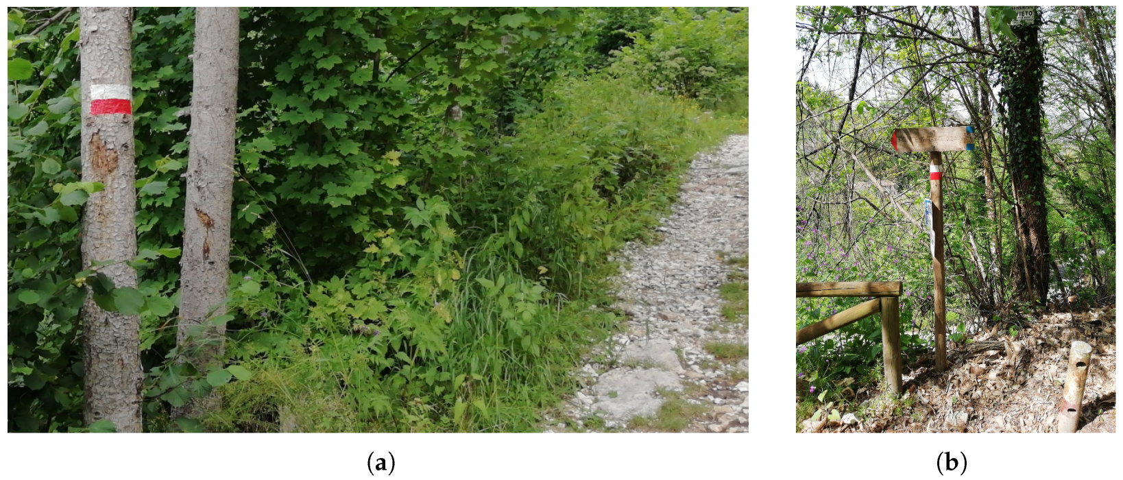
an effective signage must guide the tourist across the resort. A map represents a starting point for this purpose, but not all visitors feel comfortable reading a map. The ideal signage should provide visible reference points and suggest actions, like “turn right after crossing the stream”. A good example of such signage is the one used by the Italian Alpine Club (CAI), consisting of colored stripes marked on tree bark (see
Figure 1a). The marks are placed in such a way that, standing near one of them, the hiker can spot the subsequent mark on the trail;
a sign should explain the reasons for interest in a site. This generic characterization includes all sorts of semantic characterizations of the site and may have educational or motivational intents. This includes describing historical facts related to the site, as well as advertising nearby points of interest (see
Figure 1b). In this sense, the CAI signal above is not sufficient. A simple board with a site name only fits when the site is sufficiently popular. Otherwise, a more structured message should be used to pursue an educational purpose.
In our study, we consider a range of solutions that support sustainable tourism, specifically the dynamic provision of information during a visit along a natural trail not covered by Internet connectivity. We consider the presence of two stakeholders for the signage itself [
9]: the hosting organization (the “host” for short) that implements a signing installation, and the visitor (or “user”) who extracts information from the signing devices.
The purpose of such an installation is guiding the user on a tour that includes urban streets, buildings, natural trails, and caves (the latter being the topic of the project giving financial support to our research). The task of the host organization is to provide the user with all sorts of information to guide him across the visit, making it as profitable and enjoyable as possible.
A traditional approach makes use of physical information boards with graphical or textual content, as in
Figure 1. Our study starts by pointing out the issues related to such a solution:
dimensions: the board must be sufficiently large to contain the desired content, taking into account its readability from a distance;
installation logistics: depending on the location, the transportation and placement of a plaque may require a base or other sort of support;
environmental impact: to be effective, a plaque has to be prominent, and this may negatively affect the quality of the site;
accessibility for the visually impaired: a plaque is not useful for visually impaired persons;
accessibility for foreign visitors: to limit the size of the plaque, the number of translations must also be limited;
update limits: to update the content, the plaque must be replaced;
removal logistics: when a board degrades, it must either be removed or replaced, which entails waste disposal, together with other issues similar to those found during the installation.
Such points motivated an investigation to find alternative methods.
2.1. Technology to Minimize Intrusion
We characterize our approach as an instance of weak sustainability: we do not preclude intervention in the environment, but the impact of such intervention must be less than that related to traditional signs. To this end, in our solution, we include tools that are not part of the site but remain with the user.
During the last decades, we have witnessed the diffusion of smartphone devices, and we have no reason to expect a change in such a trend. Smartphones enhance the communication capabilities of individuals by allowing them to receive sound, visual, and tactile interactions. The relevance of such capabilities for improvement of tourist experience has been widely investigated, both in urban environments [
10] and in a rural milieu [
11], to find ways to exploit such tools. As we did with physical information boards, we highlight the limitations of this technology, particularly when it comes to outdoor activities.
One limitation is that smartphones, although widely available, are not equally familiar to everybody. This is related to “usability”, with a term borrowed from P. Wan in [
9]. The second is that various functions depend on the provision of enabling services: for instance, their networking capability is useless if the device cannot reach the Internet. Thus, the applicability limits of a smartphone-based solution need to be defined.
Starting from the two aspects above, we envision guidelines for a successful strategy, keeping in mind its sustainability.
Regarding usability, the basic recommendation is to keep operation within the experience of the majority of users, without requiring them to familiarize themselves with new applications.
The definition of applicability limits is more complex, especially for outdoor activities. In such cases, the provision of a networking infrastructure incurs a severe environmental impact. Consider the installation of antennas to cover a wide area and the power supply for the radios.
2.2. Related Works
The research literature has marginally covered the utilization of smartphones for tourist signage purposes.
An exhaustive solution is described by P. Liu in [
10], which details an infrastructure that guides visitors in an urban milieu. In that case, the presence of pervasive networking facilities is a cornerstone of the whole architecture, which deeply depends on Internet connectivity.
Wan [
9] evaluated quality of signage, without referring to a specific technology, but with many examples showing physical boards, using universal design principles [
12] as a formal reference.
The number of research papers explodes when we extend the range to articles investigating smartphones’ impact on tourism. The “smart tourism” topic is very popular and has been covered by several review papers that provide a framework for the vast literature.
A popular research direction covers the social aspects related to the use of smartphones. W. Tan [
13] covers all aspects of a touristic experience related to the smartphone, from the definition of travel destination to assistance during the visit. Much attention is dedicated to the network of connections that is established thanks to the smartphone, which, again, is on the Internet. Such an assumption is in contrast with this title, which indicates an outdoor-based destination, where notably the Internet is not always reachable.
On the other hand, roaming in places not reached by the Internet, or “dead zones” using the term introduced by Pearce and Gretzel in [
14], may evoke contrasting feelings, from rewarding to threatening.
More recently, the smartphone has been considered as not strictly related to communication. In 2021 A. Slavec et al. investigated the use of cameras [
15] while at travel in locations with a relevant cultural heritage to sustain preservation and engage tourists using location-based games, similarly to Pokemon Go or geo-caching.
In 2023, V. Rodrigues et al. published a systematic review of papers considering the interrelationships between tourism and portable digital devices [
16]. Although their title evokes a one-way contribution, therefore assuming digitalization improves the quality and sustainability of touristic offers, in the conclusions, the authors reveal an awareness of the need to address “the preservation of tourism attractions/sites” and call for a “a holistic approach
… to support a concept that still lacks conceptual and empirical clarification”.
In that direction, we meet the phenomenon of overtourism, as covered by the significant literature reviewed by Dodds and Butler [
17], which focuses on urban tourism and its social consequences. The impact of overtourism on resorts that trade on their natural resources was investigated in the case of the Hawaii Islands [
18] and Costa Rica [
19], stressing the impact on the social fabric.
The present paper wants to fill the gap highlighted by Rodriguez, providing a conceptual yet pragmatic approach to a well-defined aspect of tourism support, taking into account its sustainability “by design”. Once a range of relevant solutions has been identified, we proceed to the empirical part: a proof of concept implementation that verifies the feasibility of a specific solution.
2.3. A Simple, Low-Impact Solution
The wireless capabilities of a smartphone are the focus of a straightforward approach, which however reveals critical issues. Given the premise that the Internet is assumed to be unreachable, the host stakeholder might provide a local network of low-power radios covering the region of interest. Small servers connected to the network would host specific Web services. This approach requires a modest investment and a marginal environmental impact: for instance, a small device based on the ESP8266 single-chip computer (SCC) has a coverage of tens of meters and a volume in the order of cm. It can provide a WiFi access point as well as Web content. The ESP8266 has a capacity of 32KB, which is sufficient for explanatory text and a low-resolution image. Other SCCs, like the ESP32, are more powerful but exhibit a higher power consumption.
Such a solution is severely limited by the dependency on a power supply. A radio transmitter is a rather power-consuming device, in the range of Watts. Even if intermittent, the operation of a battery-operated networking device cannot be guaranteed for long periods, and the host organization should consider power harvesting, which negatively contributes to the economic cost and environmental footprint of the device.
For this reason, we do not consider a solution based on the deployment of a networking facility as a valid competitor against traditional board-based design. As explained, the reasons for this are related to poor sustainability.
An alternative consists of the utilization of passive devices, like near field communication (NFC) transmitters. The transmitting device is flat, the size of a coin, and costs less than one dollar per piece. To receive the content, the smartphone must be very close to the NFC tag. The power needed to operate the radio is drained from the smartphone so that the transmitter does not depend on batteries. The NFC device capacity is in the range of the KBytes, nearly a page of this journal. Engraving content onto an NFC tag is a straightforward task that requires a smartphone and an ad hoc app.
Reading a tag does not require an ad hoc application and is performed by moving the smartphone toward the tag: the user is alerted that content is available. The smartphone can read it aloud to compensate for a user’s inability or translate to deal with linguistic issues. Such capabilities do not need an Internet connection but currently depend on ad hoc applications.
Another solution in the family of passive devices is the QR code (QR stands for quick response). Such a technology does not require radio communication but uses the smartphone camera to acquire text encoded in a graphical code. The capacity of a QR tag depends on the number of dots in the image, which in turn depends on the size of the code and the smartphone camera characteristics. We can consider that the capacity of a QR tag roughly equals that of an NFC tag. A QR tag is larger than an NFC tag of comparable capacity, and manufacturing requires a printer.
Figure 2 gives an idea of their sizes.
A preliminary check verified the compliance of the passive technologies described above with the universal design principles [
12]:
Equitable use is closely related to smartphone technology, which is itself considered a vehicle for equitability;
Flexibility in use is enabled by the device capabilities, which allow listening instead of reading, translating the information to a different language, or storing it for later use;
Simple and intuitive use holds since the operation requires a single application, possibly already installed since it is useful in many circumstances, and tag reading requires a single finger touch on the smartphone;
Perceptible information is a critical requirement, which contrasts with the need to keep a low environmental intrusion. This point will be further discussed in the section devoted to the implementation;
Tolerance for error: there is no chance of accidentally causing a hazardous situation using the QR tag. The unintended release of the passive device into the environment represents a minor pollutant;
Low physical effort holds, although the user needs to carry a smartphone;
Size and space for approach and use need to be carefully considered. In the case of the NFC tag, the smartphone needs to be nearly in contact with the passive device, while the QR code must be in the line of sight and frameable without effort.
Compared with other smartphone-based technologies, there is a trade-off concerning capacity. However, a signage application with a capacity of 2–300 words is sufficient to provide directions for the visit and convey text-based educational content. If capacity limits are not an issue, a solution based on NFC or QR tags would exhibit several advantages:
does not require a power supply;
has a limited impact on the landscape;
does not entice theft;
has a negligible cost;
is durable;
produces a limited quantity of waste when disposed of;
content can be stored for later usage; for instance, to visit a URL once the user reaches a zone covered by the Internet;
is inclusive regarding user inabilities and nationality;
requires only basic technical skills from the user.
The two passive technologies of choice exhibit the following features that may make one of them preferable for a specific application:
an NFC tag is smaller than a QR tag;
writing an NFC tag requires a smartphone, while the QR tag requires a printer;
reading an NFC tag works near-to-contact, while QR tags can be read from a distance;
For a signage application, a QR tag is preferable because a noticeable size is needed. In addition, keeping the tag out of reach prevents vandalism and misuse. Therefore we have reasons to select a QR-tag-based solution for smartphone-based signage.
The QR code was invented in 1994 for industrial applications. The current version, described in [
20], dates from February 2015.
In our use case, this is especially appropriate when the cultural heritage extends across scarcely accessible land, considering that preserving and accessing sites located on private property or in hazardous areas can be challenging. In such cases, QR tags could improve the visitors’ experience by providing, when Internet coverage is available, Web URLs for videos, aerial shots, and photos, even if the specific spot is not accessible. Such resources allow visitors to immerse themselves in the area’s history and gain an experiential understanding.
We now examine how such technology can overcome the limits of a traditional board-based approach:
dimensions: a 2–300 character QR code has dimensions in the order of 100 cm;
logistics: QR code boards can be installed on any sort of pre-existent or natural support;
impact: the board has minimal interference with the landscape and may easily go unnoticed;
accessibility for the visually impaired: the text can be read aloud;
international: the text can be translated automatically;
update: the board can be easily replaced when the content becomes obsolete;
disposal: the card releases a limited quantity of pollutants related to ink support (paper or plastic).
The host needs to resolve two issues. One problem is the balance between visual impact and visibility. Monitoring tag utilization, which is useful for all types of planning activities, is the other topic. These are discussed in
Section 4.
3. Materials and Methods
Our study aims to demonstrate a sustainable solution in a concrete setting through a proof of concept. In order to follow a holistic approach, we must start with the definition of the operational framework.
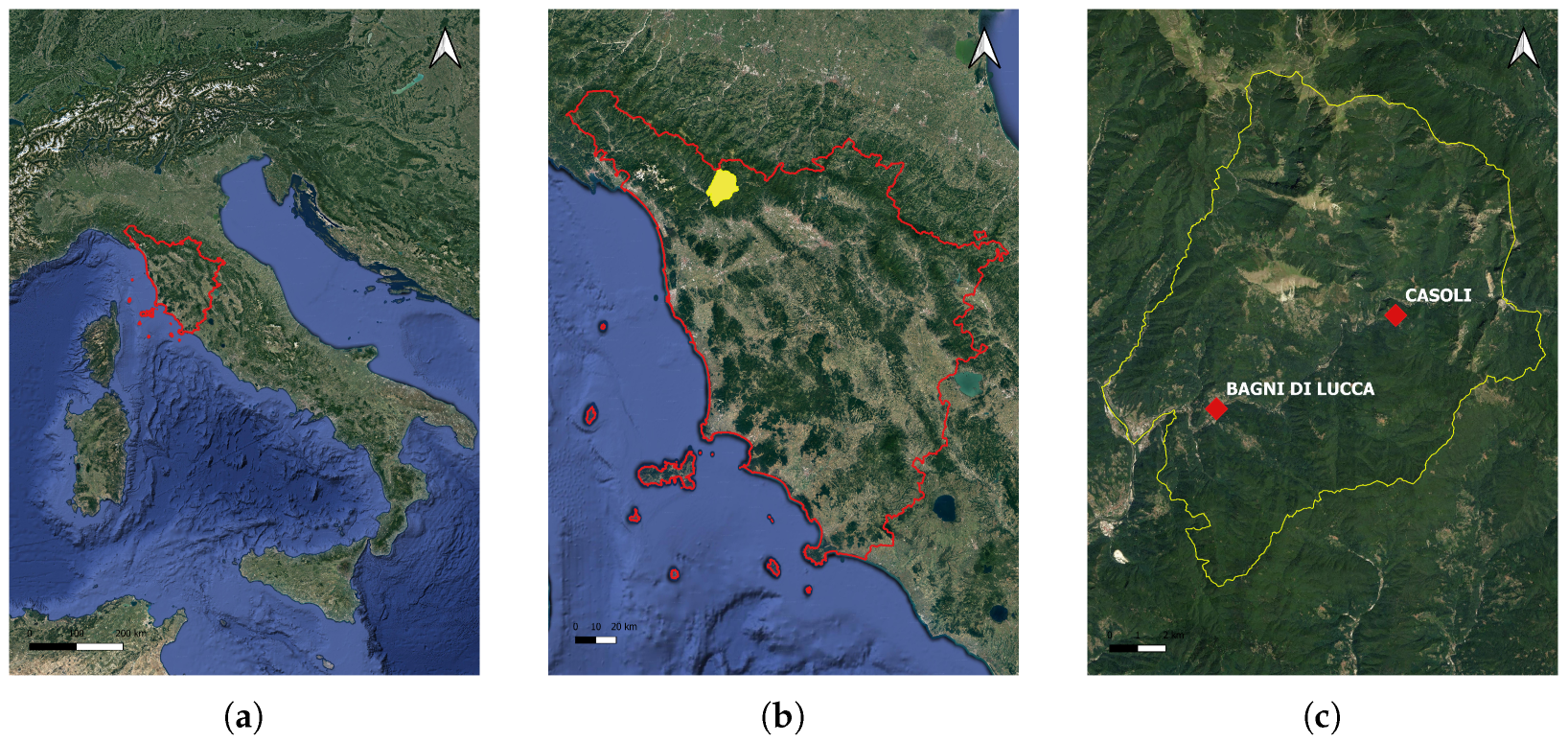
This section is dedicated to describing the economic and social context, as well as the historical background that characterizes the heritage resource we want to promote. The geographical area of interest is the surroundings of Casoli, a small village in a mountainous region in the north of Tuscany, Italy. The area falls within the municipality of Bagni di Lucca, in the province of Lucca. In 2021, the archaeological team of our project realized a thematic map assessing the aspects of interest of the heritage and the geomorphological features of the area.
3.1. The Natural and Cultural Assets of Casoli and Its Vicinity
Bagni di Lucca is located on the north-eastern boundary of the Province of Lucca, in Val di Lima, and is part of the Media Valle del Serchio district.
Figure 3 geographically localizes the region. With its mountains, it marks the historical border with the Modena and Pistoia area, it is very rich in potential for its natural, archaeological, and historical heritage, both expressed and as yet unexpressed. Thanks to the archaeological map, the main sites of interest from prehistoric to contemporary times in this municipality have been cataloged, photographed, and georeferenced.
From a historical-geographical point of view, this area is identified with the Lima stream and its tributaries, which impress the area with a peculiar geomorphology, impervious despite the modest hilly elevations.
The Lima stream has always characterized the history of Bagni di Lucca: the valley’s ancient river terraces contain some of the earliest evidence of human presence, such as caves and rock shelters frequented since the Palaeolithic age; manufacturing industry (paper mills, flour mills and, in recent times, energy production) has been exploited from the Middle Ages until the 1980s [
21,
22,
23].
On the naturalistic side, the region of Bagni di Lucca encompasses an incredible concentration of biodiversity, counting no less than three sites in the Natura 2000 Network [
24] European Economic Community (EEC) initiative.
There are three SCIs-SACs (Sites of Community Interest and Special Areas of Conservation) located in the area north of the Lima stream, corresponding to the Apennine portion, covering 23% of the municipal surface:
The latter is also a SPA (Special Protection Area) and the
Orrido di Botri State Reserve is located within it [
24]. This is therefore natural heritage with a fragile balance that needs to be preserved.
In recent years, the main tourist attractions have become concentrated on the Lima stream, with some associations and private entities promoting outdoor experiences, particularly fluvial sports, such as canyoning, rafting, and paddleboarding. Other important tourist attractions include trekking and hiking, supported by a network of paths tracked by the local CAI (Club Alpino Italiano).
In the last few years, the community has opened two entirely new trails:
Another recently developed project (2019) has been the expansion of Saint Bartholomew’s Path, which runs through the territory of
Pistoia, with a variant from
Popiglio that continues in five stages in the municipality of
Bagni di Lucca to
Pieve di Controne, acting as the ”
Lucca gateway” to the path [
26].
Such initiatives have led to a considerable revival of interest among Italian and international hikers in the area, especially regarding the Apennine side of the valley.
The best way to improve the valorization and enjoyment of this area involves a slow tourism approach. This approach can involve the community, especially in the southern part of the municipality, which is still less frequented, more hilly, and therefore less traveled by the network of trails. We envision the creation of heritage trails characterized by the rediscovery of the historical roads, partly well-preserved, which connected the villages with the valley bottom and between them, including the sites of interest that encapsulate the history of this area, starting with the caves.
A Historical Perspective of an Italian Mountain Site
This section outlines the historical framework that explains the selection of the QR tag locations and their associated content. This was based on previous archaeological and historical investigations. The sites mentioned in the narration can be found among the QR codes listed in
Table 1.
The village of
Casoli is located south of the
Lima stream on a hill named
“Tanette”. Locally meaning ”small lair”, this name reveals the presence of karstic cavities, some inhabited between the Paleolithic and the Iron Age and also used as stations on the trans-Apennine routes [
21,
27,
28,
29,
30].
Ceramic fragments dated between the 3rd century BC and the 1st–2nd centuries AD prove that Ligurian populations occupied the region in scattered groups and small nuclei. The dedication of the Latin colony of
Lucca in 180 BC marked a decisive turning point in the Romanisation of the area and, shortly after, the definitive subjugation of the Ligurian populations, accompanied by rapid acculturation [
27,
31].
We have little evidence of Roman settlements in the mountainous hinterland, and the scarce archaeological traces are concentrated in the cave of
Buca La Piella, investigated in 1975 by the Centre for Archaeological Studies of
Lucca; it has two entrances joined by a walkable tunnel and rooms of small dimensions that overlook the outside. In addition to numerous faunal remains and fragments of locally produced common pottery, twenty bronze coins from the 3rd century AD, as well as bronze and lead objects, were found [
27,
32,
33].
In Longobard and Carolingian times,
Lucca’s
Val di Lima was one of the three administrative districts into which the mountains were divided and was called
fines Contronenses [
34,
35,
36]. The only find from this period is the
Grotta di Arzale, a rock shelter that opens up northwest of
Casoli [
27].
The first attestation of the settlements of
Casoli and
Lacu dates back to the 10th century [
27]. Most documents from this period show the division and alienation of ecclesiastical heritage in favor of the city aristocracy, securing an accumulation of funds and power that was to form the basis of the subsequent domains [
27,
34,
37,
38].
Written sources mention a castle in
Casoli from 1180, but its foundation must have been earlier. Between the 13th and 15th centuries, the fortification was at the center, along with the other castles of the
Val di Lima, of clashes between
Lucca,
Pisa, and
Firenze, with alternating fortunes, as it was a strategic border area for the power of
Lucca. Today, very little is preserved, and the area is sparsely inhabited [
27,
37,
39].
The same document from 1180 mentions the church of
San Donato, located in the main square of the village of
Casoli. The current structure dates back to the 12th–13th centuries, with subsequent renovations. Initially dedicated only to
San Donato, it acquired a double dedication after the abandonment of the church of
Sant’Andrea de Lacu. The latter is located on a plateau to the east of
Casoli lake and is attested from 1260 [
27,
40,
41], but we are aware that it was abandoned in the 15th century. [
27,
42]. This was probably due to the depopulation of the lake area and the simultaneous strengthening of the town of
Casoli, which was fortified and better protected during this unstable period.
Today, the Romanesque church of Sant’Andrea de Lacu is in a state of decay, with a rectangular plan, ending on the east side with a semi-circular apse. Inside, there is a reused element of the previous building, testifying to an older origin, probably contemporary with the ancient settlement of Lacu, meaning “lake” and mentioned in sources from the 10th century, and no longer visible today.
In the early modern age, villages of the area experienced a progressive architectural renewal, which still largely characterizes the settlements today. Within
Casoli, a series of residential buildings with imposing portals are preserved, some with courtyards, as well as mansions that denote a discrete deployment of resources by the wealthy social classes. Also dating from the modern era is the
Madonna di Castello oratory, characterized by an entrance enclosure and located along the cobbled road that traces the ancient route between the village and the summit area of the medieval castle [
27].
Along the road that led toward
Lucchio and crossing the area of
Casoli lake, there is the chapel of
Madonna di Col di Piano and two “
metati”, buildings used for drying chestnuts, from the contemporary age. Referred to as the “bread tree”, chestnut fruits and the flour derived from them were a staple of the mountain diet until the mid-1900s [
43,
44].
3.2. An Integrated View of Tourism in the Casoli Region
The the touristic context of a territory is crucial in understanding the socio-cultural system of potential tourist destinations. In light of this and for a holistic study approach to social features of tourism, the host and traveler relationship is directly related to the local development and local government systems [
45]. In this study, the perception of and community empowerment in local tourism are crucial for future destination planning. On the socio-economic side, it is fundamental to understand touristic data and indexes that are specifically related to
Bagni di Lucca’s tourism dynamics, as the administrative land hosting
Casoli. From this perspective, the following paragraph concerns Bagni di Lucca’s demography and a touristic data analysis that will be used for local sustainable governance measures.
3.2.1. Tourism Dynamics in Bagni di Lucca, the Val di Lima, and Casoli
In Italy, a municipality is the smallest geographical-administrative unit offering accessible data about tourism, which are the fundamentals of our research.
Bagni di Lucca owes part of its charm to the river Lima, which runs through the city before flowing into the Serchio River. The Lima Valley (Val di Lima in the local idiom) is a touristic basin set in the Serchio Valley, dotted with medieval and Roman villages with historical remains, such as underground caves. The Val di Lima area is well-known for its environmental beauty, including rupestrian and lake ecosystems, and offers a wide range of tourist attractions related to sports, from water sports, such as canyoning and rafting, to trekking on water and land, climbing, mountain biking, and horseback riding. Overall, the Val di Lima has the capabilities to promote a very strong destination brand, straddling the town of Lucca and the mountain area of the Garfagnana.
The strategic position of
Bagni di Lucca is one of the strengths of its tourism context, together with the presence of such attractive elements like the
Orrido di Botri [
46] with the
Canyon Park [
47], as well as other service companies and associations for experiential tourism.
To give a complete insight into the mentioned touristic area, a socio-cultural approach is needed, by also considering tourism flows. From this perspective, it must be considered that there is no touristic information at the administrative level of
Casoli, so the tourism context analysis concerns the municipality area of
Bagni di Lucca, as the first territorial context providing tourist data registered by ISTAT (National Statistical Institute) [
48]. The demographic trends (
Figure 4a) enlighten about relevant aspects of
Bagni di Lucca society and economic aspects of its touristic ecosystem (
Figure 4b).
Bagni di Lucca stretches over a 164.70 km
area with a population density of 33.95 inhabitants per square kilometer and a job occupancy rate of 33.53%. Regarding human growth at the territorial level, it is relevant to consider the
Bagni di Lucca population trend during the 2001–2022 period. The curve in
Figure 4a registers a constant and slight decrease of one thousand people over a twenty-year time frame (2001: 6556 people; 2022: 5593 people).
During recent decades, numerous touristic operators have started their activities by taking advantage of the climatic and morphological characteristics of the territory. From a quantitative perspective, it is relevant to understand the tourist trends over a 5-year time frame; the chart in
Figure 4b highlights a decreasing trend from 2017 to 2021 considering the pandemic impacts on tourism.
The tourism density index is the rate between the number of tourists and the surface area in the highest tourist season. It was 106.41 tourists per km
in 2022. The arrivals exhibited a drop from 2019 (from 4339 in 2017 to 2363 in 2021), and tourist visits suffered a slight decrease during the same period, as shown in
Figure 4b, while a further increase was registered in 2022 (5.876 arrivals).
The touristic area of Val di Lima features a tourist area belonging to the Bagni di Lucca Municipality, the second touristic area after Barga, in the Media Valle del Serchio Area.
Table 2 provides statistical data concerning tourist flows and accommodation in
Bagni di Lucca. Notably, the tourist density of 106.41 tourists per km
is higher than the population density (33.95 inhabitants per km
). This information should be considered in local planning, to enhance the number of residents.
As shown in
Table 2, the number of nights per tourist amounted to an average of 2.98 nights per tourist over a year, and this is also significant, since it shows, on the one hand, the
Bagni di Lucca context is appealing for tourists choosing to stay more than a weekend and less than a week. On the other hand, this data show how long people like staying in this tourist region and that they may have found the attractions, services, and activities they required. Consequently, a well-organized touristic system attracts potential touristic visits spread widely over the municipality territory.
The coexistence index describes the distribution of tourist nationalities: 103.74 foreign tourists per 100 Italians in Bagni di Lucca indicates a significant share of foreign tourists.
For a benchmarking point of view, the provincial touristic context of
Lucca is mentioned in this study, to highlight the percentage weight of
Bagni di Lucca tourism flows within the overall tourism dynamics of the Province of
Lucca. As concerns the tourist indexes shown in
Table 2, the touristic density counts 1866.96 people per square kilometer (1773 km
), with an average stay of 3.36 nights per tourist, showing a medium-length stay in the provincial territory; this data are in line with the average stay of
Bagni di Lucca (2.98 nights). The provincial area of
Lucca shows an accommodation density of 19.30 on 10.14 for
Bagni di Lucca, while the coexistence index for
Lucca (with 69.87 foreign tourists per 100 Italian tourists) is lower than
Bagni di Lucca’s coexistence index (with 103.74 foreign tourists per 100 Italian tourists). It can be claimed that
Bagni di Lucca is well positioned in the overall touristic context of
Lucca, since it represents one of the less populated municipalities in the territory with interesting tourist indexes. In fact,
Bagni di Lucca boasts a historical thermal tourism tradition, together with a well-equipped environment for sport and adventure tourism, over a surface of 164.70 km
, which is one of the largest municipality areas in the province of
Lucca.
Several promotional websites, like [
49,
50], advertise the attractions of
Bagni di Lucca. The sitography closing this paper contains a longer yet incomplete list of touristic initiatives [
47,
50,
51,
52,
53,
54,
55,
56,
57,
58,
59].
From the point of view of our research, the context of Bagni di Lucca helps to understand the complexity and variety of mixed tourism clusters (a sort of “touristic ecosystem” with common identifying elements such as anthropic, socio-cultural, and historical features, as well as touristic services). Indeed, Val di Lima can promote a very strong destination brand, straddling the town of Lucca and the Garfagnana mountain area. The Municipality of Bagni di Lucca and the tourist area of the Val di Lima are the context for the small and fascinating village of Casoli, which is one of the 31 villages belonging to the Municipality. It is 7.22 km far from Bagni di Lucca, at an altitude of 500 m.
Casoli village boasts a heterogeneous range of tourist attractions, including both soft and hard outdoor experiential activities, such as canyoning, rafting, and trekking experiences in the Canyon Park. Additionally, it features Romanesque churches and huts attracting visitors looking for various experiences, such as thermal, environmental, outdoor, sports, and cultural activities. Throughout the year, local stakeholders offer a variety of services, often incorporating sustainable tourism practices. After a detailed analysis of the tourist and social context of
Bagni di Lucca, it can be claimed that the area boasts a good tourist appeal for Italian and foreign tourists searching for various kinds of touristic experiences [
60], which date back to the 90’s when some associations began organizing trekking excursions and rafting experiences.
As part of
Bagni di Lucca’s ecosystem, with its focus on tourism,
Casoli is a destination for slow travel. It is important to ensure that any development actions taken are sustainable, to preserve its unique social fabric. This means paying attention to the conservation of the environment and cultural heritage, as well as preserving intergenerational continuity and economic equity [
3].
3.2.2. Guidelines for Sustainable Development
Based on the tourism trends of Casoli, and aligned with the research goals focused on sustainability, it is crucial to consider the role of local policy-makers. They play a vital role in planning and monitoring sustainable measures and their impact.
In these terms, as described by [
61] Dianne Dredge, and in light of the above analysis, private and public entities could contribute to sustainable tourism by developing the following actions:
Public actions:
- −
to foster an inclusive stakeholder approach for the tourism ecosystem;
- −
to promote a community-involved tourism vision;
- −
to monitor and analyze tourism flows;
- −
to plan a slow tourism development strategy, to achieve environmental, cultural, and socioeconomic sustainability objectives;
- −
to develop digitization tools and strategies for culture and tourism fruition.
Professional actions:
- −
to renovate experiential tourism using a sustainable approach;
- −
to develop potential touristic areas with unrealized tourism appeal;
- −
to diversify tourism offers based on tourist provenance and service preferences;
- −
to monitor tourism flows and tourist behaviors;
- −
to foster a public–private collaboration approach to using public funds for tourism and cultural projects, toward sustainable objectives.
The abovementioned tourism and culture measures should be included in a wider and holistic planning vision for
Bagni di Lucca as a heterogeneous cultural and sustainable destination. The combination of private and public interest as a long-term strategy for a comprehensive tourism approach needs a bottom-up vision, involving residents and local operators in tourism and tourism-related sectors [
62,
63].
In this way,
community-involved tourism can be a promising solution for sparsely populated areas with significant tourist attractions, such as the village of
Casoli. This type of tourism involves active participation and entrepreneurship from the local community to promote self-employment, community management, and stakeholder decision-making processes [
64].
To create a successful strategic plan, it is crucial to have a thorough understanding of the destination’s morphology, environment, history, culture, society, and economy, with sustainability being the key value. Policymakers should recognize such needs and act in this way, both politically and socially, as described by Beatrix et al. in [
65]. As concerns the empiric case of
Casoli village, within the wider context of
Bagni di Lucca, tourism is a key driver of repopulation and requalification strategies, where historical and archaeological sites can be promoted with natural attractions.
In such a context, digitalization plays a primary role in innovative actions, allowing effective monitoring of tourism dynamics, improving the touristic experience with geolocalization tools, and providing the tools to design and operate tourism initiatives [
63].
3.2.3. How to Implement the Guidelines?
According to the above guidelines for tourism valorization, we explain how the research was conducted dealing with local stakeholders. Although information is still incomplete, we were able to collect sufficient opinions to confirm that Casoli has the potential to be promoted through a community-involved tourism approach.
We included four stakeholder communities in the evaluation of the response to the initiative. We do not speak about success, since the initiative is deliberately soft, with an outcome expected in years, and the definition of the evaluation criteria raises new questions. We are content with determining if the stakeholders viewed the initiative as intrusive, helpful, or simply neutral.
We considered four stakeholder communities:
the residents the local community that currently inhabits the site;
the entrepreneurs who currently have a business on the site;
the administrators that are in charge of managing the site resources and that, at the due time, will respond to the two stakeholders above, and finally;
the users, those that come to Casoli to visit the Cave of La Piella and that will find the QR codes on their way.
Considering that each stakeholder category has specific concerns that need to be addressed, our focus was on understanding the unique characteristics of each category, including their needs and expectations about tourism and environmental development.
Regarding the residents, we had the chance to meet a few people living in Casoli, which did not provide useful information; local entrepreneurs we met informed us about the trekking tourism flows passing through Casoli and the Piella cave path, which usually starts from the Canyon Park experience.
The administrators of Bagni di Lucca Municipality were highly involved in addressing the study’s concerns and provided valuable information regarding archaeological and cultural aspects that aligned with our results.
A QR tag does not record reading operations, preventing an evaluation of the user category. A URL was added to the text message in the QR tag to monitor the number of hits; however, this is not an effective usage estimator, as explained in
Section 4.
In light of the above, a reflection on community-involved tourism perspective is needed. As shown by this empirical study, a small village like Casoli requires a valorization strategy that takes advantage of the wider local tourism context.
According to a holistic development vision, when a tourist destination supports its community issues, this means that local stakeholders must balance a tourist industry vision with sustainability goals with a comprehensive perspective on the long-term environment, socio-cultural, and economic benefits, as described by George B. Et Alii [
66].
Indeed, a multi-stakeholder approach could represent a valuable tool for “minor tourism” and well-established tourist destinations.
The literature on this scientific focus, as described by Richards G. and Derek H. [
67], gives evidence of the role of local stakeholders’ as designers of their living territory. This is particularly important in inland and marginal tourist areas that require a sustainable approach to development, rather than relying on mass tourism.
A systemic vision is necessary to manage these areas effectively. With these concerns in mind, inner area governance needs a sustainability-led community and policy approach, considering the local socio-cultural aims for tourism system implementation and environmental development. In these terms, local awareness is fundamental for private and public stakeholders, to enable sustainable decision-making processes.
Pragmatically, the scientific aim of our territorial exploration was to promote cultural and tourist points of interest with high tourist value. In this regard, we analyzed the potentiality of involving local administrations and professional tourism operators to create new tourist itineraries by valorizing existing hiking trails.
First, a municipal structural plan should include an archaeological survey; second, local tourism stakeholders will benefit from destination management actions to promote environmental and socio-cultural sustainability.
Moreover,
community-involved tourism may represent the balanced intersection between community and development through policymakers’ actions and decision-making [
68]. In this view, the socio-political framework of tourism, involving governance measures, has to include environmental requalifying and destination planning [
67].
Policy measures for sustainable and resilient tourism should focus on culture-led and community empowerment activities, such as preserving the history and memory of a place, promoting slow tourism and cultural innovation, as well as implementing digitalization activities.
3.2.4. Sites and Trail’s State of the Art
This section defines the points of interest where the QR tags were positioned and reports on their accessibility and state of conservation. This may be relevant from the perspective of spotting the segment of users that may take advantage of the tags.
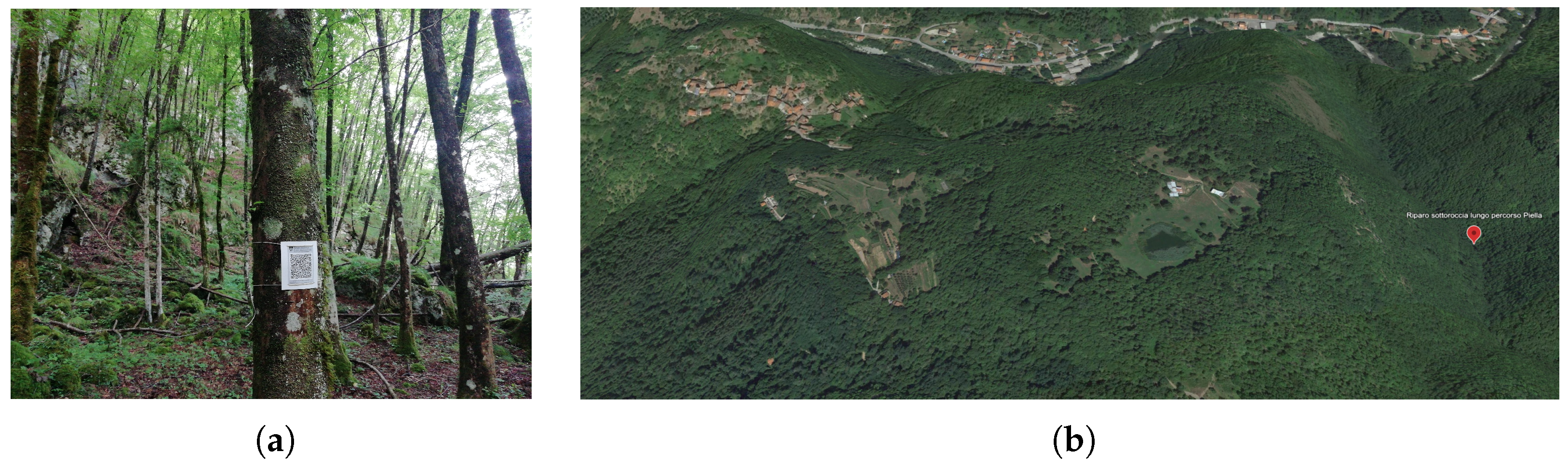
The cave named Buca La Piella is the foremost site from an archaeological point of view. It is located in a fascinating environment outside conventional circuits, which is why it is less frequented and consequently less compromised. It is reachable by leaving a marked path to follow the bed of a tributary of the Lima stream. The trail is dotted with minor karst caves, and the Buca La Piella is reachable by climbing up on a steep slope in the wood on the left of the watercourse.
Not far from the Buca La Piella on the same side of the river is another karst cave named Antro dell’Ugola. It is reachable by following a faint and intermittent track that departs from a marked path. It is characterized by a suspended geological formation resembling an uvula, hence the name.
Both caves are going to be analyzed in the course of the Underlandscape project [
7,
69], and the findings can further enhance the interest in both sites.
Along a dirt road from the village in the direction of the lake of Casoli are some of the most interesting sites. The medieval remains of the church of Sant’Andrea de Lacu, now in a state of serious disrepair, without its roof and with static problems, but characterized by Romanesque forms and 10th-century decorations.
The metati (structures for drying chestnuts), together with the hundred-year-old chestnut trees, testify to the exploitation of forest resources since the Middle Ages.
A little further along the CAI path is the oratory named Madonna di Col di Piano. Recently renovated, its canopy has been a shelter for wayfarers since modern times.
Inside the town of Casoli, narrow streets branch off the main square, where the medieval church dedicated to the Saints Donato and Andrea with its bell tower can be admired. From here, an ancient street climbs to the top of the hill. On the way up, there is a small oratory called Madonna di Castello that is still consecrated but in poor condition.
On the summit are the remains of the medieval castle with its walls. In need of consolidation of the walls, it cannot be visited at the moment, as it is on private property; it is only possible to observe part of its structure from the path.
Two other sites that are particularly curious but cannot be visited because they are located on private property are the so-called Celtic Calendar, an artificially excavated rock interpreted as a kind of sundial, and an epigraph reused in a house interpreted as Lombard.
3.3. Implementing QR-Based Signage
The concept behind the implementation of the QR-based signage was to guide the visitor through a self-organized experience. To verify in the field the practical aspects and deployment, we realized and placed several QR tags. A list is given in
Table 1.
The proposed signage cannot replace CAI signs (see
Figure 1a), which are recognized throughout the country and is very effective. The QR-based signage complements it and provides more detailed information at multiple levels. For one, the availability of written directions along the trail leading to the
Buca La Piella, which is hard to follow and not covered by CAI signage, is of great help to inexperienced hikers.
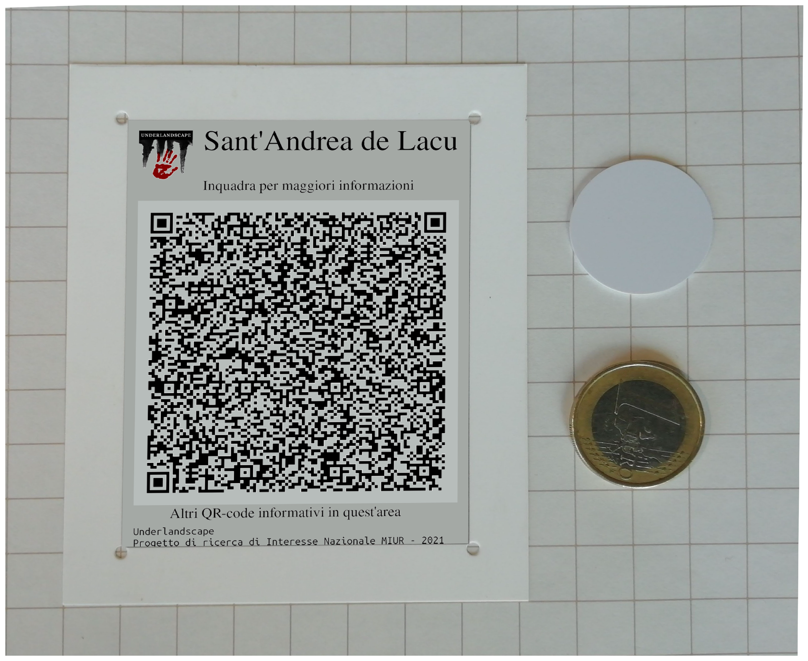
Tags were printed on Synaps™, a non-biodegradable polyester synthetic film by Agfa-Gevaert NV. Agfa documents the production process, giving guarantees of sustainability [
70]. According to Agfa, Synaps is more sustainable than laminated paper. From previous experience, it is also more durable.
To minimize the environmental footprint, the tags were attached to preexisting structures, like trees or poles. The tags were tied with a thin biodegradable string, as in
Figure 5a.
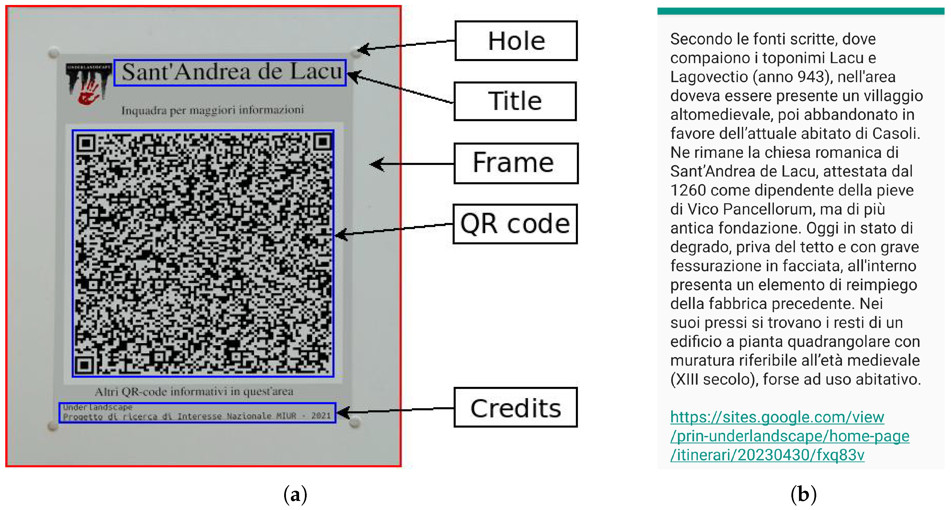
The QR tag was designed to implement three levels of reading (LoR), with an increasing level of technology involved:
visual: information is printed on the tag. The user does not need any technology to read the content;
QR tag text: this is the text encoded in the tag. The user needs a smartphone-like device and an appropriate app to read aloud or translate the content;
URL: these are Web URLs encoded in the tag text. The user needs an Internet connection to visit the URL.
We placed QR tags both along the trail and at sites of interest; the former were at detours or close range, so that from one you can see the next, as per the CAI standard [
71]. They could therefore have the function of a simple signpost to visually indicate the continuity of the trail. The second LoR gave access to the written indications recorded within it, which were more accurate and precise than those printed on the tag. The third LoR provided further capabilities, as detailed below, but was accessible only whenever the location was covered by the Internet.
There are many ways to distribute content among the three LoRs, dictated by tag purpose and location. For our experiment, we used the same organization for all tags, which privileged the second LoR, namely the text encoded in the tag (see
Figure 6a):
visual LoR (see
Figure 6a): the tag was approximately the size of a game card, 80 cm
.
of the frame (32 cm
) provided mechanical resistance to the holes needed to secure the tag.
of the remaining (48 cm
) contained the QR code,
for a heading containing the name of the location, one line instruction for use, and the project logo, and a footer (
) for further instructions and project credits;
QR text LoR (see
Figure 6b): this describes the site or gives directions to reach the destination of the trail. The text includes historical, archaeological, and naturalistic information, together with the URL for the next LoR. In our prototype, the maximum length of the text amounted to 700 characters. A Huawei FIG-LX1 (2017) decoded the tag from a distance of more than 50 cm. The same phone could read aloud the content (in Italian) without Internet connectivity;
URL LoR: such information was only useful in a few locations, since the area is not uniformly covered by broadband networks; for instance, during a recon to the
Piella cave, none of the smartphones of the participants received sufficient broadband network signal to visit the linked page. However, the application records the URL, so that the user can visit it when entering a covered area. Each web page contains site-specific information, an interactive map hosted by the uMap web service (
https://umap.openstreetmap.fr, accessed on 22 November 2023) with the location and content of all the QR tags (see the left box of
Figure 7), and a form for user feedback.
Figure 6.
QR tag parts and content. (a) QR tag parts, (b) QR tag content on a 5.5’ screen.
Figure 6.
QR tag parts and content. (a) QR tag parts, (b) QR tag content on a 5.5’ screen.
The production process of a series of tags was also investigated to streamline the task and use only basic information technology skills.
The master document was a GeoJSON file describing the area and the tagged features: a GPS tracking application was used to record an initial version of it during a recon.
The finalized master document contained a single GeoJSON FeatureCollection object containing one Feature object for each tag. Each Feature contained a Geometry object of type Point, and a properties object with fields containing information needed to create the tag: its unique identifier (fid) was a random string of six lowercase letters used to produce the associated URL, the title printed on the tag, and the text to be encoded in the QR code (see Listing 1).
| Listing 1. GeoJSON Object of a feature associated with a QR code. Ellipsis (…) are used to shorten long strings. |
| 1 | { |
| 2 | ‘‘type’’: ‘‘Feature’’, |
| 3 | ‘‘geometry’’: { |
| 4 | ‘‘type’’: ‘‘Point’’, |
| 5 | ‘‘coordinates’’: [10.67592,44.035298] |
| 6 | }, |
| 7 | ‘‘properties’’: { |
| 8 | ‘‘fid’’: ‘‘fxq83v’’, |
| 9 | ‘‘name’’: ‘‘Sant’Andrea de Lacu’’, |
| 10 | ‘‘description’’: ‘‘Secondo le ... ad uso abitativo.’’, |
| 11 | ‘‘imageTag’’: ‘‘1m0Vad1Om2ihSVezPUkMKfuCUlg3ptC6z’’, |
| 12 | ‘‘urlPrefix’’: ‘‘https://sites.google.com/…’’ |
| 13 | } |
| 14 | } |
Editing the map downloaded from the GPS app to fill in the
properties does not require technical skills, since the tools integrated into the uMap user interface already fit the purpose (see the bottom left box in
Figure 7).
The master document was rendered by uMap on the page linked to the tags, as shown in
Figure 7.
A cross-platform HTML+JavaScript application provided an app that makes the conversion of the master document into a printable array of QR tags straightforward. This code does not depend on an Internet connection and is on GitHub [
72].
4. Results and Discussion
We aimed to enhance the tourist experience in an inland area located around the village of Casoli. Our goal was closely related to the fourth pillar of sustainability: there are cultural assets that need to be nurtured or at least preserved. The proposed signage system aimed to achieve such a goal by promoting the documentation and touristic development of these assets.
To avoid the over-tourism pitfall, we needed to take into account the other three pillars: social, environmental, and economic. To this end, we analyzed the social fabric that will host our initiative, the environment where the signage will be deployed, and the economic framework that will support its implementation. From this study, we derived the requirements for our signage system: low environmental impact, open to the participation of the residents, responsive to the visitor’s information needs, and economically sustainable with minimal tourist flow.
The approach we applied to achieve such conclusions merely consisted of designing the system with sustainability in mind from the early stages. The simplicity of the description must not mislead, its implementation is challenging, requiring collaboration among experts in distinct disciplines to converge on a final result.
Our design started by defining a profile for the area according to the three pillars. The environmental aspect was characterized by natural formations and special habitats hosting great biodiversity, placed under special protection according to European legislation.
As for tourism-related economics, a qualitative and quantitative analysis [
60] revealed unique features that needed to be capitalized on to enhance the tourism potential. In this light, community-involved tourism represents a virtuous approach to destination management in inland areas that require a renewed sustainability-oriented design. Therefore, public and private stakeholders are crucial for managing spatial planning and addressing local issues through investment, conservation, promotion, and monitoring actions.
From this perspective, our research was oriented toward stimulating local policymakers and tourism professionals towards a better environmental and cultural sustainability approach by taking advantage of our study results to realize new potential heritage trails in Casoli and its vicinity.
An outcome of the analysis of the social fabric was that, to preserve the native social and economic framework, mass tourism is not a candidate target, while a motivated, non-casual visitor is preferable.
A rationale for the above attitude can be found in an article by Solima et al. [
73]. The authors conducted a poll about user perception on two segments of users: Italians and Polish. The feelings about a QR-based signage were not unanimous, and half of the Italian users considered it as not useful. Another result from the poll revealed that Polish users showed a stronger motivation to use tags for educational purposes (70% versus 50%), while Italians were mainly driven by curiosity. We conclude that, to provide a useful service, the signage must address a motivated user.
Therefore, we identified the potential reasons for a visit. We found a cave reachable with some effort inhabited since prehistory, a village with historical buildings, and nearby architecture dating back to the Middle Ages. Such targets offer a variety of routes of access, from those requiring performance to relaxing ones. For this reason, we opted not to suggest a geo-itinerary, allowing the user to cherry-pick locations based on personal interests.
We investigated a technique for guiding the visitor and telling the history of the place. The small number of expected visitors limits financial investment, while the natural heritage requires non-intrusive techniques.
The proposed solution consisted of placing the QR tags listed in
Table 1 at selected locations. The total cost of the tags amounted to a few Euros for the printing service, although finding a shop with an appropriate device may be difficult. The impact on the environment is extremely limited, as shown in
Figure 5.
To allow readability in dead zones and to quickly provide information without further steps to web pages, we encoded the content within the QR code itself. The content consisted of a text of an average of 460 characters, aiming at concise and effective communication with the tourist.
Therefore, in our design, the information encoded in the QR tag was the primary or only way of communication with the visitor. This is a new and original way of using such technology, since QR tags are often considered ancillary to other forms of communication, like physical installations or linked Web content, according with to motto “analog portal to the digital world”, as in the title of [
74].
Such an attitude has not changed much since the first reported utilization of QR tags for heritage promotion. In 2013, an early paper by Martinez et al. [
75] suggested their utilization to implement a virtual tour in the
Las Quilamas Natural Park in Spain. At that time, the availability of QR code readers was not as diffused as today, and therefore this work may be considered among the seminal ones. The authors proposed using a QR code as a link to a panel in PDF format viewed on the user’s portable device. Similar works in an urban environment were presented in [
76,
77], the latter illustrating the QR system serving the monuments in the Serbian town of Niš. Among indoor applications we have referenced [
73], which described the use of QR tags linked to Web resources in two museums in different countries.
The role of QR tags has not changed from those early days: in 2023, the authors of [
78] introduced the installation of six QR codes in a museum and analyzed the reactions of 42 visitors. The tags were created using the Taplink web service and linked to content on the Web.
We conclude that storing informational content in the tag itself is not considered as an option, which justifies the novelty of our approach.
The results of previous multi-disciplinary investigations, including archaeological surveys and access to historical documents and cartography, were used to define the informational content. Two on-site surveys provided further practical indications and the opportunity to place the QR tags.
The main result of our activity was the real-scale deployment of the signage, a non-trivial exercise in holistic sustainable design.
As a side result, we have a signage technology based on QR code tags, a benchmark difficult to improve on in terms of environmental impact and cost.
Collecting statistics about user perception was not a primary interest for us at this stage: the initiative started as an exercise and was not adequately advertised to potential users. However, we provided two ways to collect data as part of the exercise.
One was a poll at five points on the web pages linked to in each tag. The user was asked to quantify an agreement (0-do not agree, 5-strongly agree) with four sentences, and finally provide an answer:
the QR tag was useful;
a plaque would be preferable;
I will come back to visit the sites I did not visit today;
I am satisfied with my visit;
I scanned other QR codes in the vicinity.
The other method was a hit count on the pages linked to the QR tags.
Both of these proved to be ineffective. We collected only one form with positive feedback but no statistical significance. The hit count was polluted by spurious accesses to the page (for instance for maintenance, or reaching the page from the map) and by the fact that scanning the tag was not necessarily linked to a hit.
The reactions we collected by interviewing local stakeholders were positive, which gives us the impression that the initiative is respectful and consistent with the social and economic framework. The measurement of the efficacy in financial terms is currently beyond the scope of this paper and will only be assessable in the long term, depending on the collaboration of the involved stakeholders.
Although we are satisfied that the solution complies with the sustainability principles that inspired this work, we identified two issues that indicate directions for future research:
The balance between visual impact and effectiveness is critical. The current dimensions of the tag are such that the visual impact was limited, and this negatively affects its efficacy: it is easy to miss a tag containing possibly relevant information;
Monitoring visitor’s activity, like the frequency of visits to a given tag or the sequencing of visited tags, which may be of interest for managing the site, is currently ineffective.
Trading cost and simplicity for effectiveness and measurability, there are alternative solutions.
One technology that fits the requirements of our task is Bluetooth Low Energy (BLE): the autonomy of a battery-operated BLE device is comparable with the periodic maintenance of signage based on passive devices. A Bluetooth device can send a beacon to a visitor’s smartphone to indicate the presence of a passive sign, like a not-so-visible QR tag, or directly deliver information. However, this requires the installation of an ad hoc app on the visitor’s device, and the design of the IT product including the BLE device and the application, which may cost far more than the physical devices.
The demonstration of the existence of such needs biases technological evolution: for instance, if counting NFC reads were a frequent requirement, tags with such a feature would be produced at low costs, and the increment in operation might become a default in NFC reading apps. The many research results on low-energy and low-cost devices also indicate an expanding market.
5. Conclusions
Tourism, like other productive activities, is at risk of becoming unsustainable, damaging the very resources that support it. To avoid these drawbacks, the design of a tourism initiative has to consider the complex framework where it will operate according to a holistic approach. A methodology composed of examples and guidelines helps to cope with such a challenging task.
This paper is a step in that direction. We addressed a common problem, that of providing the visitor with directions, to promote slow tourism and preserve distinguishing traits of an inland area.
We showed how a balanced use of technology may help in this task, with a process that is necessarily multidisciplinary, combining skills from diverse domains: sociology, economics, humanities, and engineering. Taking into account all such aspects is a challenging task, even when applied to a limited use case. Reporting about the design process is also a complex task, as witnessed in this paper. However, the result is rewarding and we demonstrated how the multidisciplinary interplay returns ad hoc tools targeting sustainability and efficacy.
In the case of Casoli, the touristic trends and the local vocation portray a small destination for visitors utilizing heterogeneous touristic circuits in individual and combined ways. Cultural sustainability mandates the involvement of local stakeholders in planning new heritage itineraries and supporting initiatives, including signage.
The resulting implementation should be minimalist in its deployment. This may encourage the direct participation of the resident community in its implementation: from the production of the QR tags to their deployment and maintenance. The detailed description of the production process enables its reuse as a starting point in future initiatives.
From a medium-term perspective, the description of the deployed experiment gives suggestions for the development of new devices or features for existing ones. In our case, a new potential application may foster research aiming at passive or very-low-energy devices that could effectively advertise their presence or simply collect statistics in dead-zones.
From a different point of view, the lack of discoverability suggests a recreational scenario inspired by Geocaching® and Pokemon-GO®.
In conclusion, more sustainable solutions to old problems exist and are reachable by melding technology and humanities. Policy-makers are crucial in the development and monitoring of sustainable measures. This is especially important in the tourism industry, where sustainability is a multifactor topic that includes resident ecosystem resilience and regeneration efforts by both policy-makers and private tour operators.


