Assessing Endokarst Potential in the Northern Sector of Santo António Plateau (Estremadura Limestone Massif, Central Portugal)




Abstract
1. Introduction
2. Study Area
3. Material and Methods
3.1. Data Collection and Pre-Processing
3.2. Model-Building Strategy
4. Results and Discussion
5. Conclusions
Author Contributions
Funding
Institutional Review Board Statement
Informed Consent Statement
Data Availability Statement
Acknowledgments
Conflicts of Interest
References
- White, W.B. Geomorphology and Hydrology of Karst Terrains; O.U.P.: New York, NY, USA, 1988. [Google Scholar]
- Ford, D.; Williams, P. Karst Geomorphology and Hydrology; John Wiley & Sons, Ltd.: Hoboken, NJ, USA, 2007. [Google Scholar]
- Dimuccio, A.L. A Carsificação Nas Colinas Dolomíticas a Sul de COIMBRA (Portugal Centro-Ocidental—Fáceis Deposicionais e Controlos Estratigráficos do (Paleo)Carso no Grupo de Coimbra (Jurássico Inferior). Ph.D. Thesis, Departamento de Ciências da Terra da Faculdade de Ciências e Tecnologia da Universidade de Coimbra, Coimbra, Portugal, 2014. [Google Scholar]
- Tomlin, C.D. Geographic Information Systems and Cartographic Modeling; Prentice-Hall: Englewood Cliffs, NJ, USA, 1990. [Google Scholar]
- Tomlin, C.D. Cartographic Modeling in International Encyclopedia of Geography. Am. Cancer Soc. 2017, 1–6. [Google Scholar] [CrossRef] [Scilit]
- De Smith, M.J.; Goodchild, M.F.; Longley, P.A. Geospatial analysis and model building. In Geospatial Analysis: A Comprehensive Guide to Principles, Techniques and Software Tools, 6th ed.; Winchelsea Press: London, UK, 2018. [Google Scholar]
- Bolstad, P.; Manson, S. Chapter 13: Spatial Models and Modeling. In GIS Fundamentals: A First Text on Geographic Information Systems, 7th ed.; Eider Press: Saint Paul, MN, USA, 2022; pp. 561–582. [Google Scholar]
- Church, R.L. Geographical information systems and location science. Comput. Oper. Res. 2002, 29, 541–562. [Google Scholar] [CrossRef] [Scilit]
- Longley, P.A.; Goodchild, M.F.; Maguire, D.J.; Rhind, D.W. Geographic Information Systems & Science, 3rd ed.; John Wiley & Sons: Hoboken, NJ, USA, 2011. [Google Scholar]
- Huang, B. Comprehensive Geographic Information Systems; Huang, B., Thomas, J.C., Ming-Hsiang, T., Eds.; GIS methods and techniques; Elsevier: Amsterdam, The Netherlands, 2018; Volume 1. [Google Scholar]
- Gao, J. Fundamentals of Spatial Analysis and Modelling, 1st ed.; CRC Press: Boca Raton, FL, USA, 2021. [Google Scholar]
- Jennings, J.N. Karst Geomorphology; Oxford Blackwell: Oxford, UK, 1985. [Google Scholar]
- Cunha, L. Geomorfologia Estrutural e Cársica. In O Quaternário em Portugal, Balanço e Perspectivas; Colibri: Lisboa, Portugal, 1993; pp. 63–74. Available online: https://www.researchgate.net/profile/Lucio-Cunha-2/publication/324088980_Geomorfologia_estrutural_e_carsica/links/5abd07990f7e9bfc0457a68b/Geomorfologia-estrutural-e-carsica.pdf (accessed on 15 May 2023).
- Palmer, A.N. Cave Geology; Allen Press: Lawrence, KS, USA, 2007. [Google Scholar]
- Dimuccio, L.A. Tempo e espaço num geossistema cársico: Os “pilares” em que assenta e se sustenta a interpretação da sua evolução geológicogeomorfológica. In Espaços e Tempos em Geografia: Homenagem a António Gama; Imprensa da Universidade de Coimbra: Coimbra, Portugal, 2017; pp. 207–238. [Google Scholar]
- De Waele, J.; Gutierrez, F. Karst Hydrogeology, Geomorphology and Caves; John Wiley & Sons Ltd.: Hoboken, NJ, USA, 2022. [Google Scholar]
- Crispim, J.A. Dinâmica Cársica e Implicações Ambientais nas Depressões de Alvados e Minde. Ph.D. Thesis, Faculdade de Ciências da Universidade de Lisboa, Departamento de Geologia, Lisboa, Portugal, 1995. [Google Scholar]
- Rodrigues, L.M.E. Evolução Geomorfológica Quaternária e Dinâmica Actual. Aplicações ao Ordenamento do Território. Exemplos no Maciço Calcário Estremenho. Ph.D. Thesis, Universidade de Lisboa, Lisboa, Portugal, 1998. [Google Scholar]
- Brilha, J. Património Geológico e Geoconservação a Conservação da Natureza na Sua Componente Geológica; Palimage: Viseu, Portugal, 2005. [Google Scholar]
- Cunha, L.; Dimuccio, L.A.; Aubry, T. Património cársico no Centro de Portugal. O caso do Maciço de Sicó. Património Geomorfológico e Geoconservação. Experiências em Portugal e no Brasil. In Proceedings of the do I Encontro Luso-Brasileiro de Património Geomorfológico e Geoconservação, Coimbra, Portugal, 5–7 February 2014; pp. 27–34. [Google Scholar]
- Cunha, L.; Dimuccio, A.L.; Paiva, I. Geopatrimónio cársico e desenvolvimento local no Maciço de Sicó. Desafios para afirmar a Lusofonia na Geografia Física e Ambiente. II Encontro Luso-Afro-Americano de Geografia Física e Ambiente 2018. pp. 1227–1233. Available online: https://repositorio.ul.pt/handle/10451/36644 (accessed on 15 May 2023).
- Aleksandar, A.; Nemanja, T.; Slobodan, M. Karst geoheritage and geotourism potential in the Pek River lower basin (eastern Serbia). Geogr. Pannonica 2019, 23, 32–46. [Google Scholar]
- Khalaf, E.E.D.A.H. Karst Heritage as a Tourist Attraction: A Case Study in the White Desert National Park, Western Desert, Egypt. Geoheritage 2022, 14, 1–30. [Google Scholar] [CrossRef] [Scilit]
- Valjavec, M.B.; Pejnović, N.D.; Draženović, M.; Čonč, Š.; Horvat, K.P. The Transboundary Approach to Landscape Geointerpretation: Challenges in Interpretive Planning and Geoconservation. Geoheritage 2022, 14, 1–13. [Google Scholar] [CrossRef] [Scilit]
- Rodrigues, H.A.; Rodrigues, M.L.; Lobo, H.S. Espeleoturismo em Portugal: Panorama Geral do Uso Turístico das Cavidades Naturais. Rev. Rosa Dos Ventos-Tur. E Hosp. 2017, 9, 92–106. (In Brazilian) [Google Scholar]
- Torres, E.; Spoladore, A.; Cunha, L. Espeleoturismo: Nota preliminar sobre as realidades paranaense e portuguesa. In Paisagem e Território; UEL: Londrina, Brazil, 2018; pp. 83–88. [Google Scholar]
- Ballesteros, D.; Fernández-Martínez, E.; Carcavilla, L.; Jiménez-Sánchez, M. Karst Cave Geoheritage in Protected Areas: Characterisation and Proposals of Management of Deep Caves in the Picos de Europa National Park (Spain). Geoheritage 2019, 11, 1919–1939. [Google Scholar] [CrossRef] [Scilit]
- Chiarini, V.; Duckeck, J.; De Waele, J.A. Global Perspective on Sustainable Show Cave Tourism. Geoheritage 2022, 14, 1–27. [Google Scholar] [CrossRef] [Scilit]
- Hobléa, F. Expertise et Médiation Scientifique Pour la Gestion Durable de L’Environnement Karstique; Actes de la réunion annuelle de la Société Suisse de Géomorphologie (SSGm), Gestion durable de l’environnement karstique; Persée: Paris, France, 2004; pp. 25–42. [Google Scholar]
- Leslie, A.N. Informal Karst Education in the United States and Internationally. Ph.D. Thesis, Department of Geography, University of South Florida, Tampa, FL, USA, 2011. [Google Scholar]
- Abdellah, A.B.; Jamila, R.; Ahmed, B.; Elhassan, L.; Samir, N. The Karst Landscapes of Beni Mellal Atlas (Central Morocco): Identification for Promoting Geoconservation and Tourism. Quaest. Geogr. 2022, 41, 87–109. [Google Scholar]
- Velasquez, M.; Hester, P.T. An analysis of multi-criteria decision making methods. Int. J. Oper. Res. 2013, 10, 56–66. [Google Scholar]
- Zlaugotne, B.; Zihare, L.; Balode, L.; Kalnbalkite, A.; Khabdullin, A.; Blumberga, D. Multi-Criteria Decision Analysis Methods Comparison. Environ. Clim. Technol. 2020, 24, 454–471. [Google Scholar] [CrossRef] [Scilit]
- Vakilipour, S.; Sadeghi-Niaraki, A.; Ghodousi, M.; Choi, S. Comparison between Multi-Criteria Decision-Making Methods and Evaluating the Quality of Life at Different Spatial Levels. Sustainability 2021, 13, 4067. [Google Scholar] [CrossRef] [Scilit]
- Taheri, K.; Gutiérrez, F.; Mohseni, H.; Raeisi, E.; Taheri, M. Sinkhole susceptibility mapping using the analytical hierarchy process (AHP) and magnitude-frequency relationships: A case study in Hamadan province, Iran. Geomorphology 2015, 234, 64–79. [Google Scholar] [CrossRef] [Scilit]
- Moradi, S.; Kalantari, N.; Charchi, A. Karstification Potencial Mapping in Northeast of Khuzestan Province, Iran, using Logic and Analytical Hierarchy Process (AHP) techniques. Geopersia 2016, 6, 265–282. [Google Scholar]
- Zaree, M.; Javadi, S.; Neshat, A. Potential detection of water resources in karst formations using APLIS model and modification with AHP and TOPSIS. J. Earth Syst. Sci. 2019, 128, 76. [Google Scholar] [CrossRef] [Scilit]
- Vargas, H.S.; Almeida, J.A.; Kullberg, J.C.; Brito, M.G. Prospecção interactiva de endocarso através de uma aplicação SIG. Finisterra 2003, 38, 51–64. [Google Scholar]
- Aken, M.V.; Harley, G.L.; Dickens, J.F.; Polk, J.S.; North, L.A. A GIS-based modeling approach to predicting cave disturbance in karst landscapes: A case study from west-central Florida. Phys. Geogr. 2014, 35, 123–133. [Google Scholar] [CrossRef] [Scilit]
- Auler, A. Cave protection as a Karst conservation tool in the environmentally sensitive Lagoa Santa Karst, Southeastern Brazil. Acta Carsologica 2016, 45, 131–145. [Google Scholar] [CrossRef] [Scilit]
- Gunn, J.; Gillieson, D.; Auler, A.; Bolger, T. Guidelines for Cave and Karst Protection, 2nd ed.; International Union of Speleology: Postojna, Slovenia; IUCN: Gland, Switzerland, 2022. [Google Scholar]
- Theilen-Willige, B.; Malek, H.A.; Charif, A.; El Bchari, F.; Chaïbi, M. Remote Sensing and GIS Contribution to the Investigation of Karst Landscapes in NW-Morocco. Geosciences 2014, 4, 50–72. [Google Scholar] [CrossRef] [Scilit]
- Telbisz, T.; Mari, L.; Albert, G. GIS Research of Karst Terrains in Hungary. In Cave and Karst Systems of Hungary. Cave and Karst Systems of the World; Veress, M., Leél-Őssy, S., Eds.; Springer: Berlin/Heidelberg, Germany, 2022; pp. 249–274. [Google Scholar]
- Hamed, Y.; Hadji, R.; Ahmadi, R.; Ayadi, Y.; Shuhab, K.; Pulido-Bosch, A. Hydrogeological investigation of karst aquifers using an integrated geomorphological, geochemical, GIS, and remote sensing techniques (Southern Mediterranean Basin—Tunisia). Environ. Dev. Sustain. 2023, 1–33. [Google Scholar] [CrossRef] [Scilit]
- Cooper, A.; Farrant, A.; Price, S. Karst, GIS and geological hazard planning and management in Great Britain. In 2º Workshop Internazionale, I Sinkholes, Gli Sprofondamenti Catastrofici Nell’ambiente Naturale ed in Quello Antropizzato; Istituto Superiore per la Protezione e la Ricerca Ambientale: Rome, Italy, 2010; pp. 242–256. [Google Scholar]
- Zhang, C.; Qi, X.; Wang, K.; Zhang, M.; Yue, Y. The application of geospatial techniques in monitoring karst vegetation recovery in southwest China: A review. Prog. Phys. Geogr. Earth Environ. 2017, 41, 450–477. [Google Scholar] [CrossRef] [Scilit]
- Fathi, S.; Sjåstad, J.H.; Hoseen, A.H. Synthesizing existing frameworks to identify the potential for Managed Aquifer Recharge in a karstic and semi-arid region using GIS Multi Criteria Decision Analysis. Groundw. Sustain. Dev. 2020, 11, 100390. [Google Scholar] [CrossRef] [Scilit]
- Mokarram, M.; Mohammadizadeh, P. Prediction of karst suitable area using fuzzy AHP method and Dempster-Shafer theory. Earth Space Sci. 2021, 8, e2019EA000719. [Google Scholar] [CrossRef] [Scilit]
- Martins, A.F. Maciço Calcário Estremenho. Contribuição Para um Estudo de Geografia Física. Ph.D. Thesis, Faculdade de Letras da Universidade de Coimbra, Coimbra, Portugal, 1949. [Google Scholar]
- Rodrigues, M.L. The Limestone Massif of Estremadura. In Landscapes and Landforms of Portugal. World Geomorphological Landscapes; Vieira, G., Zêzere, J., Mora, C., Eds.; Springer: Berlin/Heidelberg, Germany, 2020; pp. 229–250. [Google Scholar]
- Fleury, E. Portugal Subterrâneo, Ensaio de Espeleologia Portuguesa; Coleção Natura: Lisboa, Portugal, 1925. [Google Scholar]
- Thomas, C. Cova da Velha. Espeleo Divulg. 1985, 4, 30–35. [Google Scholar]
- Ferreira, A.B.; Rodrigues, M.L.; Zêzere, J.L. Problemas da Evolução Geomorfológica do Maciço Calcário Estremenho. Finisterra 1988, 23, 5–28. [Google Scholar] [CrossRef] [Scilit]
- Crispim, J.A. Características cársicas das rochas carbonatadas da região central do Maciço Calcário Estremenho. Algar Bol. Soc. Port. De Espeleol. 1992, 3, 9–18. [Google Scholar]
- Canais, F.; Fernandes, J. Lapas e Algares da Serra de Santo António; SubTerra—Grupo de Espeleologia: Torres Novas, Portugal, 1999. [Google Scholar]
- Azerêdo, A.C. Jurássico Médio do Maciço Calcário Estremenho (Bacia Lusitânica): Análise de fácies, micropaleontologia, paleogeografia. Ph.D. Thesis, Departamento de Geologia da Faculdade de Ciências da Universidade de Lisboa, Lisboa, Portugal, 1993. [Google Scholar]
- Azerêdo, A.C. Geometry and facies dynamics of Middle Jurassic carbonate ramp sandbodies. West-Central Portugal. Geol. Soc. Lond. Spéc. Publ. 1998, 149, 281–314. [Google Scholar] [CrossRef] [Scilit]
- Inês, N. Paleotipologias Diagenéticas em Formações Carbonatadas do Jurássico Médio da Bacia Lusitânica: Análise Multiscala e Aplicações à Caraterização de Reservatórios. Master’s Thesis, Estratigrafia, Sedimentalogia e Palentologia, Departamento de Geologia da Faculdade de Ciências da Universidade de Lisboa, Lisboa, Portugal, 2010. [Google Scholar]
- Carvalho, J.M. Tectónica e caraterização da fraturação do Maciço Calcário Estremenho, Bacia Lusitânica. Contributo para a Prospeção de Rochas Ornamentais e Ordenamento da Atividade Extrativa. Ph.D. Thesis, Departamento de Geologia da Faculdade de Ciências da Universidade de Lisboa, Lisboa, Portugal, 2013. [Google Scholar]
- Rocha, R.B.; Soares, A.F. Algumas reflexões sobre a sedimentação jurássica na orla meso-cenozóica ocidental de Portugal. Mem. Notícias Univ. Coimbra 1984, 97, 133–142. [Google Scholar]
- Kullberg, J.C.; Rocha, R.B.; Soares, A.F.; Rey, J.; Terrinha, P.; Axerêdo, A.C.; Callapez, P.; Duarte, L.V.; Kullberg, M.C.; Martins, L.; et al. A Bacia Lusitaniana: Estratigrafia, Paleogeografia e Tectónica. In Portugal, Vol. II, Geologia Meso-Cenozóica de Portugal. Escolar Editora; Dias, R., Araújo, A., Terrinha, P., Kullberg, C., Eds.; Escolar Editora: Lisboa, Portugal, 2013; pp. 195–347. [Google Scholar]
- Daveau, S. O Relevo de Portugal. Grandes Unidades Regionais; Feio, M., Daveau, S., Eds.; Associação Portuguesa de Geomorfólogos: Coimbra, Portugal, 2004; pp. 61–73. [Google Scholar]
- Saaty, T.L. A scaling method for priorities in hierarchical structures. J. Math. Psychol. 1977, 15, 234–281. [Google Scholar] [CrossRef] [Scilit]
- Saaty, T.L. Axiomatic foundation of the analytic hierarchy process. Manag. Sci. 1986, 32, 841–855. [Google Scholar] [CrossRef] [Scilit]
- Saaty, T.L. Theory and Applications of the Analytic Network Process: Decision Making with Benefits, Opportunities, Costs, and Risks; RWS Publications: Pittsburg, PA, USA, 2009. [Google Scholar]
- Ishizaka, A.; Labib, A. Analytic Hierarchy Process and Expert Choice: Benefits and limitations. Oper. Reasearch Soc. 2009, 22, 201–220. [Google Scholar] [CrossRef] [Scilit]
- Saaty, T.L.; Ergu, D. When is a Decision-Making Method Trustworthy? Criteira for Evaluating Multi-Criteria Decision-Making Methods. Int. J. Inf. Technol. Decis. Mak. 2015, 14, 1171–1187. [Google Scholar] [CrossRef] [Scilit]
- Bi, J.; Bennett, K.P. Regression Error Characteristic Curves. In Proceedings of the Twentieth International Conference on Machine Learning 2003, (ICML-2003), Washington, DC, USA, 23–24 June 2003; pp. 43–50. [Google Scholar]
- Oliveira, S.M.C. Incidência Espacial e Temporal da Instabilidade Geomorfológica na Bacia do Rio Grande da Pipa (Arruda dos Vinhos). Ph.D. Thesis, Universidade de Lisboa, Lisboa, Portugal, 2012. [Google Scholar]
- Klimchouk, A.; Ford, D.; Palmer, A.; Dreybrodt, W. Spleogenesis, Evolution of Karst Aquifers; National Speleological Society January: Huntsville, AL, USA, 2000; 527p. [Google Scholar]
- Paiva, I.M.R. Hidrossistema Cársico de Dregracias-Sicó. Estudo do Funcionamento Hidrodinâmico a Partir das Suas Respostas Naturais. Ph.D. Thesis, Faculdade de Letras da Universidade de Coimbra, Coimbra, Portugal, 2014. [Google Scholar]
- Seif, A.; Ebrahimi, B. Using GIS to evaluate degree of karstification according to some important factors in carbonate rocks in Iran. Carbonate Evaporites 2014, 29, 107–126. [Google Scholar] [CrossRef] [Scilit]
- Nola, I.T.S.; Bacellar, L.A.P. Multi-criteria analysis for mapping susceptibility to iron formation caves development in the Gandarela mountain range (MG), southeast Brazil. Int. J. Speleol. 2021, 50, 137–187. [Google Scholar] [CrossRef] [Scilit]
- Al-shabeeb, A.R. The Use of AHP within GIS in Selecting Potential Sites for Water Harvesting Sites in the Azraq Basin—Jordan. J. Geogr. Inf. Syst. 2016, 8, 73–88. [Google Scholar] [CrossRef]
- Azerêdo, A.C. Formalização da litostratigrafia do Jurássico Inferior e Médio do Maciço Calcário Estremenho (Bacia Lusitânica). Comun. Geológicas 2007, 94, 29–51. [Google Scholar]
- Salomon, J.N. Précis de Krastologie; Presses Universitaries de Bourdeaux: Bourdeaux, France, 2000. [Google Scholar]
- Figueiredo, R.F. Modelação Cartográfica em Ambiente SIG Para Apoio à Decisão: Aplicação ao Estudo da Afectação Potencial de Usos do Solo no Sector Norte do Maciço Marginal de Coimbra. Master’s Thesis, Faculdade de Letras da Universidade de Coimbra, Coimbra, Portugal, 2001. [Google Scholar]
- Ramos, A.; Cunha, L.; Cunha, P. Application de la Méthode de l’Analyse Multicritère Hiérarchique à l’étude des glissements de terrain dans la région littorale du centre du Portugal: Figueira da Foz—Nazaré. Geo-Eco-Trop Liège 2014, 38, 33–44. [Google Scholar]
- Fielding, A.H.; Bell, J.F. A review of methods for the assessment of prediction errors in conservation presence/absence models. Environ. Conserv. 1997, 24, 38–49. [Google Scholar] [CrossRef] [Scilit]
- Bennett, B.; Ibrahim, A.M. The Assessment of Machine Learning Model Performance for Predicting Alluvial Deposits Distribution. Procedia Comput. Sci. 2014, 36, 637–642. [Google Scholar]
- Saaty, T.L. How to make a decision: The analytic hierarchy process. Eur. J. Oper. Res. 1990, 48, 9–26. [Google Scholar] [CrossRef] [Scilit]
- Hämäläinen, R.P.; Salo, A.A. The Issue is Understanding the Weights. J. Multi-Criteria Decis. Anal. 1997, 6, 340–343. [Google Scholar] [CrossRef]
- Goepel, K. AHP Excel Template with Multiple Inputs 2018, Version AHPcalc-v2018-09-15; Business Performance Management Singapore: Singapore, 2018; Available online: https://bpmsg.com/ (accessed on 15 May 2023).
- Barton, H.A. Biospeleogenesis. Treatise on Geomorphology; Shroder, J., Frumkin, A., Eds.; Karst Geomorphology; Academic Press: San Diego, CA, USA, 2013; Volume 6, pp. 38–56. [Google Scholar]
- Rauch, H.W.; White, W.B. Lithologic controls on the development of solution porosity in carbonate aquifers. Water Resour. Res. 1970, 6, 1175–1192. [Google Scholar] [CrossRef] [Scilit]
- Waltham, A.C. Origin and development of limestone caves. Prog. Phys. Geogr. Earth Environ. 1981, 5, 242–256. [Google Scholar] [CrossRef] [Scilit]
- James, N.P.; Choquette, P.W. Diagenesis 9, Limestones—The Meteoric Diagenetic Environment. Carbonate Sedimentol. Petrol. 1984, 4, 45–78. [Google Scholar]
- Manupella, G.; Telles, A.M.; Costa, C.A.; Azerêdo, A.C.; Barbosa, B.; Cardoso, J.L.; Crispim, J.A.; Duarte, L.V.; Henriques, M.H.; Martins, L.T.; et al. Notícia Explicativa da Folha 27-A Vila Nova de Ourém; Departamento de Geologia, Instituto Geológico e Mineiro: Lisboa, Portugal, 2000. [Google Scholar]
- Dunham, R.J. Classification of Carbonate Rocks According to Depositional Texture. In Classification of Carbonate Rocks; Ham, W.E., Ed.; American Association of Petroleum Geologists: Tulsa, OK, USA, 1962; pp. 108–121. [Google Scholar]
- Cunha, L. As Serras Calcárias de Condeixa-Sicó-Alvaiázere. Estudo de Geomorfologia. Ph.D. Thesis, Faculdade de Letras da Universidade de Coimbra, Coimbra, Portugal, 1988. [Google Scholar]
- Trudgill, S.T. Field observations of limestone weathering and erosion in the Malham District, North Yorkshire. Filed Stud. 1985, 6, 201–236. [Google Scholar]
- Ghung, C.F.; Fabbri, A.G. Validation of Spatial Prediction Models for Landslide Hazard Mapping. Nat. Hazards 2003, 30, 451–472. [Google Scholar]
- Guzzetti, F.; Reichenbach, P.; Cardinali, M.; Galli, M.; Ardizzone, F. Probabilistic landslide hazard assessment at the basin scale. Geomorphology 2005, 72, 272–299. [Google Scholar] [CrossRef] [Scilit]

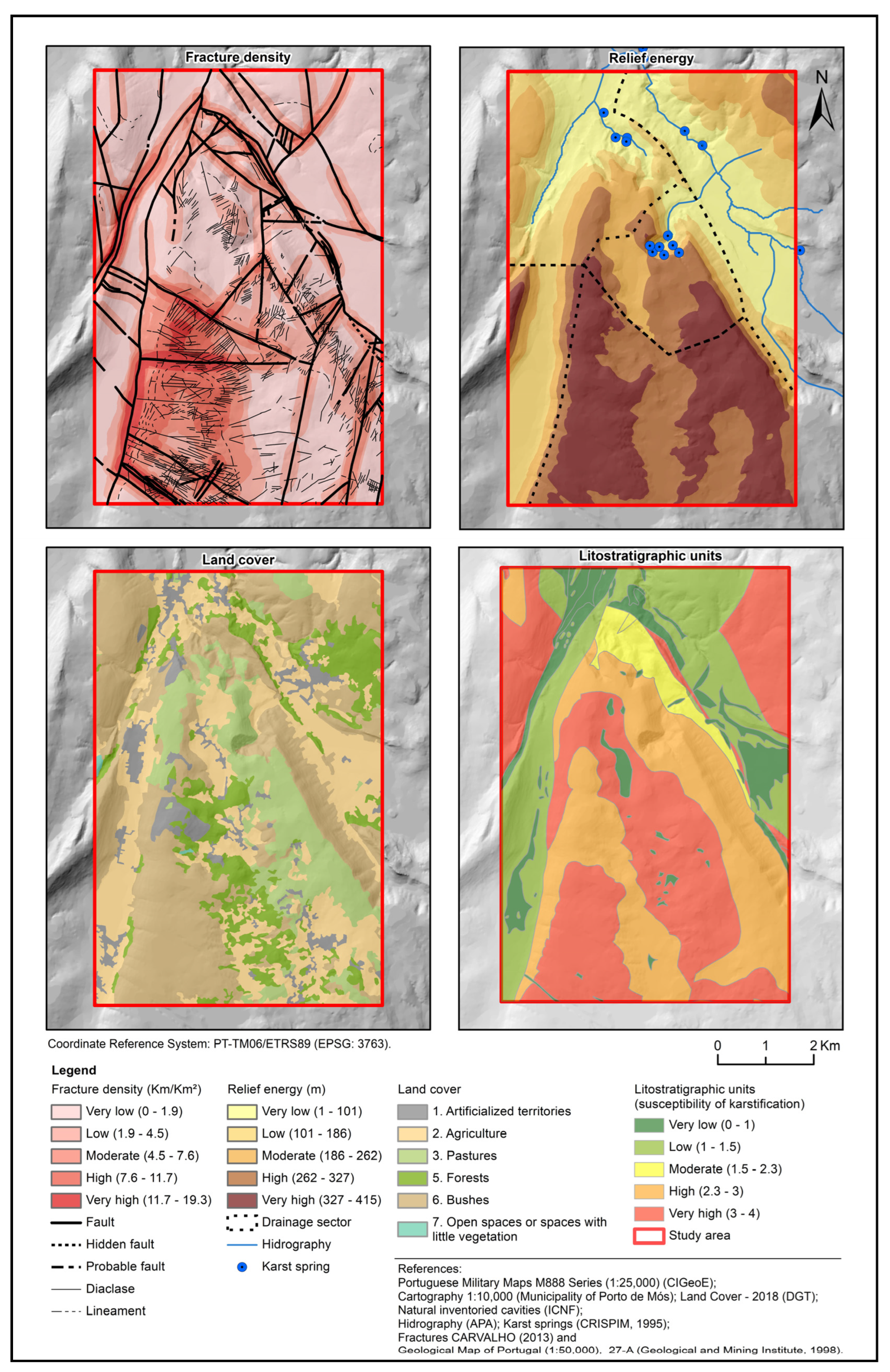
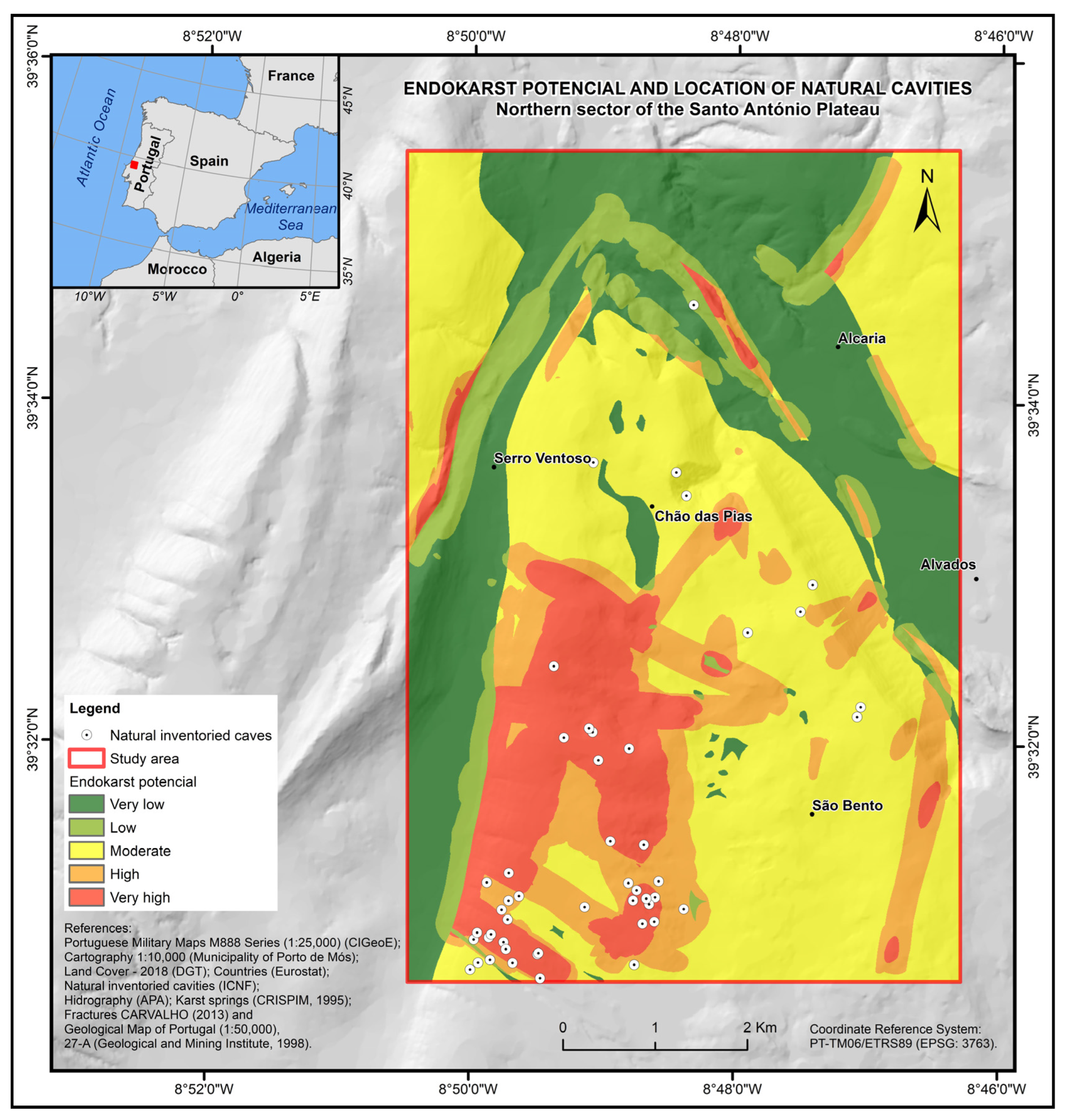
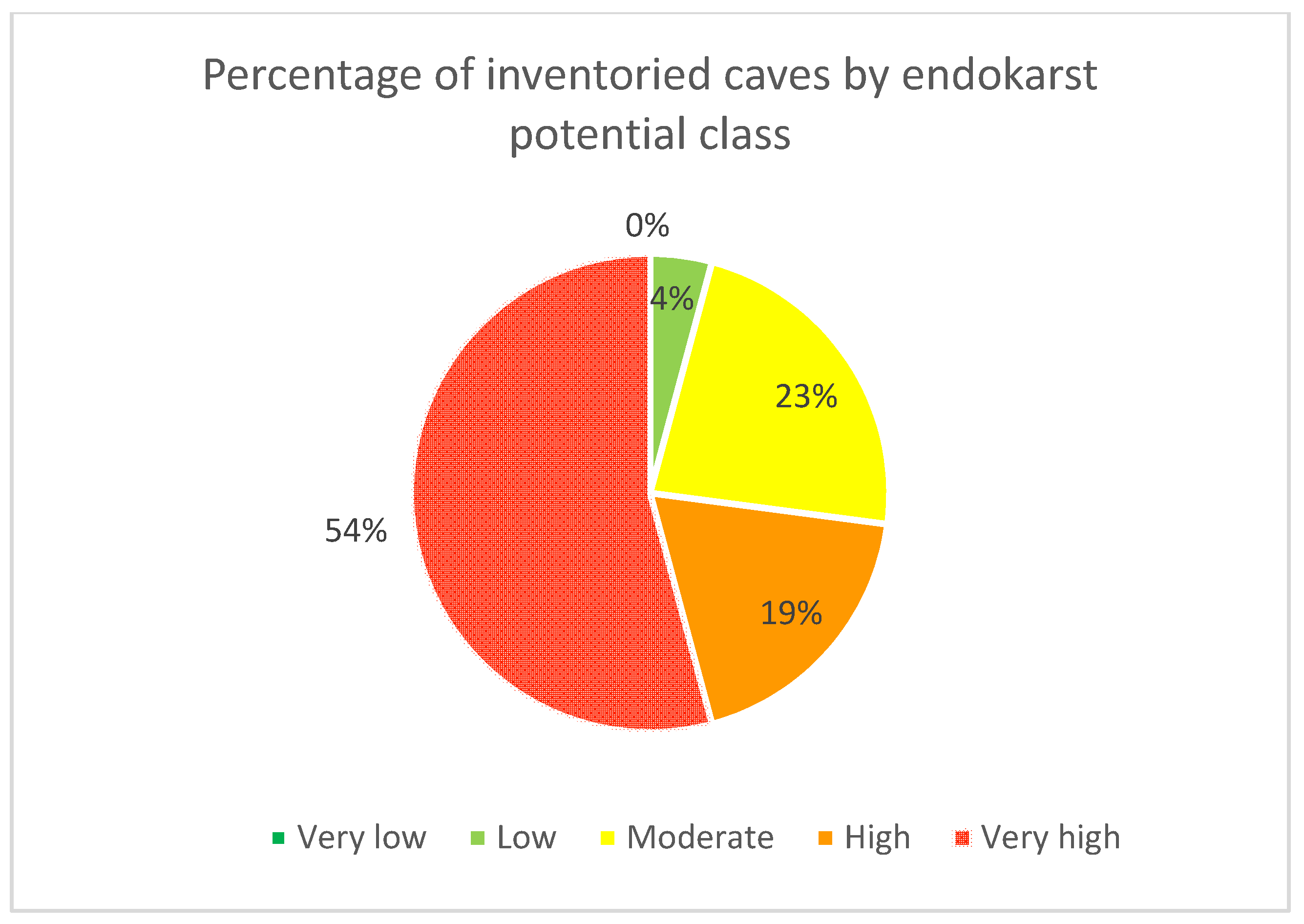
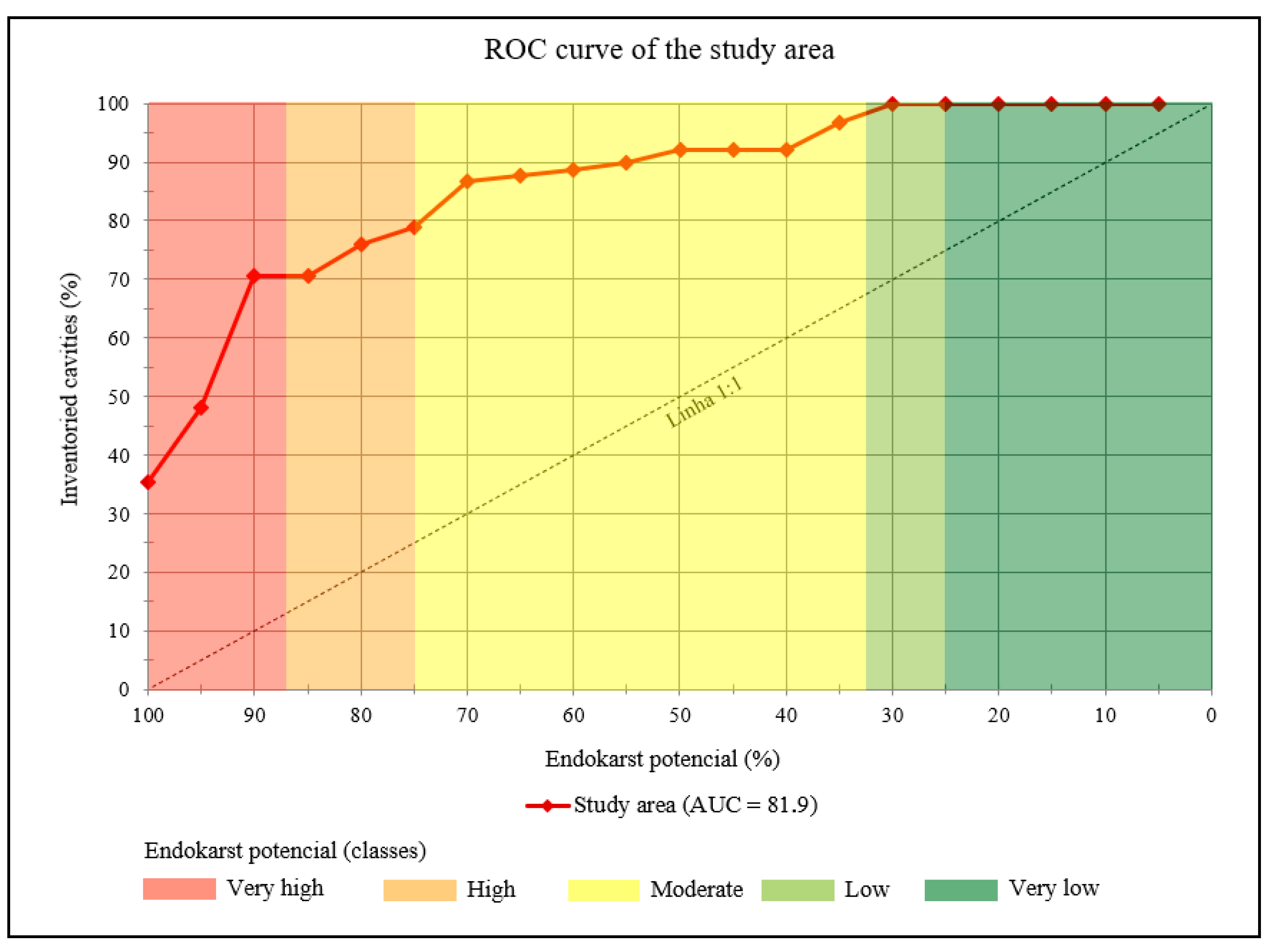

| Classification | Data Collection of the Study Area | Derived Raster Thematic Layer | ||
|---|---|---|---|---|
| (Spatial Database) | GIS Data Type | Scale or Resolution | Source or Citation | (Conditioning Factor) in a GIS |
| Geological data | Lithology (polygon-vector) A | 1:50,000 | IGM | Lithostratigraphic units |
| Strata geometry (point-vector) | 1:50,000 | Carvalho [59] | ||
| Tectonic structures (line-vector) | 1:50,000 | Carvalho [59] | Fracture density | |
| Topographic data | Contours (line-vector) B | 1:10,000 | PMM | Relief energy |
| Points elevation (point-vector) B | 1:10,000 | PMM | ||
| Hydrogeological data | Drainage sectors (polygon-vector) | 1:50,000 | Crispim [17] | |
| Karstic springs (point-vector) | 1:50,000 | Crispim [17] | ||
| Land cover data | Land cover (polygon-vector) C | 1:25,000 | DGT | Land cover |
| Speleological data | Karstic cave entrances (point-vector) D | 1:100,000 | ICNF | Location of known cave entrances |
| Intensity of Importance | Definition | Explanation |
|---|---|---|
| 1 | Equal Importance | The two criteria contribute equally to the objective |
| 3 | Moderate Importance | Experience and judgment moderately favour one criterion over the other |
| 5 | Strong Importance | Experience and judgment strongly favour one criterion over the other |
| 7 | Very Strong Importance | A criterion is strongly favoured, and its dominance is demonstrated in practice |
| 9 | Extreme Importance | The evidence favours one criterion over the other with a high degree of certainty |
| 2, 4, 6, 8 | Values associated with intermediate judgments | When you want a greater compromise between different levels of intensity |
| Criteria (Related to the Chosen Conditioning Factors) | C1 | C2 | C3 | … | Cn | |
|---|---|---|---|---|---|---|
| C1 | C1/C1 | C1/C2 | C1/C3 | … | C1/C1 | |
| C2 | C2/C2 | C2/C2 | C2/C3 | … | C1/C1 | |
| C3 | C3/C1 | C3/C2 | C3/C3 | … | C1/C1 | |
| … | … | … | … | … | … | … |
| Cn | Cn/C1 | Cn/C2 | Cn/C3 | … | Cn/Cn |
| Designation A | Lithology | SC B | Facies | Granulometry, Texture and Qualitative (Apparent) Porosity C | SC | Stratonomy D | SC | Bed Geometry E | SC | S—(Qualitative Assessment) F |
|---|---|---|---|---|---|---|---|---|---|---|
| Alluvium (a); detrital unit and terra rossa of Estremadura Limestone Massif (A) | Siliciclastic deposits, sometimes with a marly component | 0 | Pelitic and sandy fácies. | Pelites and sands with a generally clast-supported texture. Excellent porosity. | 0.9 | It does not show an apparent organisation in sedimentary beds. Still, a massive structure is filling the valley bottoms (alluvium) and some depressions and crevices of a karst nature (siliciclastic deposits with terra rossa). | 0 | - | 0 | 0.9 (Very low) |
| Beds of Alcobaça (J3AI) | Marls, sometimes siltstones, limestones, and sandstones | 0.2 | Mudstones, silty-sandy carbonate clays and silty-clay sandstones. | Pelites to matrix-supported sands containing various fossiliferous associations. Poor porosity. | 0.2 | Micritic limestones; silt-sandy carbonate clays with fine calcareous intercalations; micaceous sandstones from fine to very fine; beds of sandstones forming finer intercalations; thick beds of silty-sandy clays and silty-clay sandstones. | 0.2 | Thickness about 150 to 200 m; average slope 25°(min. 15° and max. 38°). | 0.3 | 0.9 (Very low) |
| Cabaços and Montejunto beds (J3CM) | Clay limestones and marls | 0.4 | Mudstones/wackstones related to rare packstones and grainstones. | Clay micritic limestones with the presence of carbonate microcrystalline matrix. Poor porosity. | 0.4 | Limestone and yellowish marls with ferruginous concretions; very bioclastic pelmicritic clayey limestone; clay-limestone; intraclastic micritic limestone; a monogenic conglomerate of limestone matrix; very bioclastic pelmicritic limestone. | 0.3 | Thickness about 65 m; average slope 34° (min. 8° and max. 85°). | 0.2 | 1.3 (Very low) |
| Limestones of Moleanos (J2MI) | Limestones | 0.5 | Rudstones, grainstones, Oolitic/bioclastic/oncolytics/lithoclastics packstones. | Absence of carbonate crystalline matrix with grains in contact. Porosity from poor to excellent. | 0.7 | Alternations of well-calibrated oolitic limestones and coarser calciclastics; compact, pelbiomicritic limestones; succession becomes more clastic, with massive calciclastic limestones. | 0.6 | Thickness is about 150 m, probably 180–200 m; average slope between 20 to 25°. | 0.6 | 2.4 (High) |
| Micritic limestone of Serra de Aire (J2SA) | Limestones | 0.8 | Mudstones and oncolithic wackstones with fenestrae and laminations; Floastones, wackstones and mudstones with algal/oncoid nodules and rusting. | Dolomitic levels, micritic and dolomicritic limestones with carbonate microcrystalline matrix. Porosity from poor to reasonable. | 0.8 | Cyclical sequences of micritic dolomitic limestones and limestones; compact micritic, fenestrated or oncolitic limestones, with ferruginous tinges; decreased fenestrated and oncosparitic limestones, becoming fossiliferous micritic limestones; biomicritic or pelimicritic limestones. | 0.9 | Thickness from 350 to 400 m; average slope 14° (min. 2° and max. 70°). | 0.8 | 3.3 (Very high) |
| Bioclastic limestone of Codaçal (J2Co) | Limestones | 0.7 | Oolitic and bio-intraclastic Grainstones with oblique bedding; Rudstones, grainstones and bioclastic/oncolytic/lithoclastics packstones. | Biolclastic and oobioclastic and sporadically dolomitised limestones with absence of carbonate crystalline matrix. Porosity from poor to excellent. | 0.8 | Fine oolitic limestones; oolitic limestones; bioclastic and oolitic limestones with intraclasts. | 0.5 | The average thickness is about 50 to 60 m, which tends to increase to 70–80 m; the average slope is 8° (min. 5° and max. 10°). | 0.9 | 2.9 (High) |
| Limestones of Chão das Pias (J2CP) | Slightly clayey or marly limestone, limestone, dolomitic limestone | 0.7 | Mudstones, wackstones and bioclastic packstones. | Presence of carbonate microcrystalline matrix. Poor porosity. | 0.8 | Slightly clayey or marly limestone in decimeter benches with siliceous nodules; succession characterised by the alternation of micritic and calciclastic limestones. | 0.7 | Thickness is about 50–60 m, reaching, however, values >80 m? Average slope 9° (min. 5° and max. 15°). | 0.9 | 3.1 (Very high) |
| Marls and marly limestones of Zambujal (J2ZA) | Marls, marly limestones, clayey limestones, limestones. | 0.4 | Mudstones, wackstones and bioclastic packstones. | Presence of carbonate microcrystalline matrix. Poor porosity. | 0.8 | Rhythmic alternation of marls, marly limestones, and clayey limestones, in almost always thin beds. The succession becomes increasingly thick and calcareous until the marly levels disappear. It appears significantly fractured. | 0.7 | Thickness about 220–250 m; average slope 14° (min. 4° and max. 34°). | 0.8 | 2.7 (High) |
| Marl limestones and marls of Fórnea (J1−2Fo) | Marls and marly limestones | 0.4 | Grumose; wackstones; biomicrites to biosparites/grainstone; packstones to grainstones. | Presence of carbonate microcrystalline matrix/absence of carbonate microcrystalline matrix with grains in contact. Poor to reasonable porosity. | 0.7 | Succession is dominated by thin to medium beds, sometimes without rhythmic organisation. From the top occurrence of biostromal bodies with metric thickness. Micritic limestones dominate the upper meters. | 0.7 | Maximum thickness with about 220–250 m; average slope 33° (min. 19° and max. 58°). | 0.5 | 2.3 (Moderate) |
| Beds of Coimbra (J1Co) | Dolomites | 0.5 | Wackstones to grainstones. | Presence of carbonate microcrystalline matrix/absence of carbonate microcrystalline matrix with grains in contact. Poor to reasonable porosity. | 0.7 | Cross-bedding and dolomites with parallel or wavy lamination, interstratified with pellets. | 0.4 | Thickness is about 60 m (beds with vertical or slightly inverted slopes). | 0.1 | 1.7 (Moderate) |
| Platelet dolomites (J1pi) | Dolomitic limestones | 0.7 | Mudstone | Micritic dolomitic limestone. Poor porosity. | 0.2 | Beds with centimetre to decimeter thickness. | 0.1 | Thickness is about 30–40 m. | 0.2 | 1.2 (Low) |
| Marls of Dagorda (J1Da) | Sandy loams, gypsum and saliferous clays, Intercalations of dolomitic limestones | 0.1 | Sandy, pelitic and Mudstones facies for the carbonate ones. | Poor porosity. | 0.1 | Tick saliferous series with frequent clayey intercalations; evaporitic salts with intercalations of evaporitic syngenetic dolomite and gypsum; occurrence of “Dolomites in platelets”; saliferous member, with domain of halite; saliferous/dolomitic member rich in evaporites–anhydrite and halite; dolomitic/margo-dolomitic limestones with red and greyish pelites and evaporites. | 0.1 | Formation subjacent Jurassic limestones with significant thickness, >3000 m, according to sounding “São Mamede 1”. | 0.4 | 0.7 (Very low) |
| Eruptive rocks | Dolerite | 0 | - | Poor porosity. | 0 | Associated with fractures or discontinuities. | 0.8 | - | 0 | 0.8 (Very low) |
| Lithostratigraphic Units (SK *) | Very High | High | Moderate | Low | Very Low | |
|---|---|---|---|---|---|---|
| Very high | 1 | 2 | 5 | 7 | 9 | 0.46 |
| High | 1/2 | 1 | 4 | 6 | 8 | 0.32 |
| Moderate | 1/5 | 1/4 | 1 | 3 | 6 | 0.13 |
| Low | 1/7 | 1/6 | 1/3 | 1 | 3 | 0.06 |
| Very low | 1/9 | 1/8 | 1/6 | 1/3 | 1 | 0.03 |
| Fracture Density | Very High | High | Moderate | Low | Very Low | |
|---|---|---|---|---|---|---|
| Very high | 1 | 2 | 4 | 6 | 9 | 0.47 |
| High | 1/2 | 1 | 3 | 4 | 7 | 0.30 |
| Moderate | 1/4 | 1/3 | 1 | 2 | 3 | 0.12 |
| Low | 1/6 | 1/4 | 1/2 | 1 | 1 | 0.07 |
| Very low | 1/9 | 1/7 | 1/3 | 1 | 1 | 0.05 |
| CR = 0.013 | ||||||
| Relief Energy | Very High | High | Moderate | Low | Very Low | |
|---|---|---|---|---|---|---|
| Very high | 1 | 1 | 2 | 3 | 4 | 0.32 |
| High | 1 | 1 | 2 | 3 | 4 | 0.32 |
| Moderate | 1/2 | 1/2 | 1 | 2 | 3 | 0.19 |
| Low | 1/3 | 1/3 | 1/2 | 1 | 1 | 0.09 |
| Very low | 1/4 | 1/4 | 1/3 | 1 | 1 | 0.08 |
| CR = 0.007 | ||||||
| Land Cover | Forests | Pastures | Agriculture | Bushes | Open Spaces or with Little Vegetation | Artificialised Territories | |
|---|---|---|---|---|---|---|---|
| Forests | 1 | 2 | 3 | 3 | 3 | 8 | 0.35 |
| Pastures | 1/2 | 1 | 1 | 2 | 3 | 8 | 0.22 |
| Agriculture | 1/3 | 1 | 1 | 2 | 2 | 6 | 0.18 |
| Bushes | 1/3 | 1/2 | 1/2 | 1 | 1 | 7 | 0.11 |
| Open spaces or with little vegetation | 1/3 | 1/3 | 1/2 | 1 | 1 | 7 | 0.11 |
| Artificialised territories | 1/8 | 1/8 | 1/6 | 1/7 | 1/7 | 1 | 0.03 |
| CR = 0.035 | |||||||
| Karstification Factors | Lithostratigraphic Units | Fracture Density | Relief Energy | Land Cover | |
|---|---|---|---|---|---|
| Lithostratigraphic units | 1 | 2 | 4 | 5 | 0.49 |
| Fracture density | 1/2 | 1 | 3 | 4 | 0.31 |
| Relief energy | 1/4 | 1/3 | 1 | 2 | 0.13 |
| Land cover | 1/5 | 1/4 | 1/2 | 1 | 0.08 |
| CR = 0.018 | |||||
| Factors (Criteria) | Classes | Area (km2) | N.º Caves | N.º Caves/Km2 |
|---|---|---|---|---|
| Fracture density | Very low | 21.99 | 5 | <1 |
| Low | 14.67 | 6 | <1 | |
| Moderate | 9.55 | 11 | 1.15 | |
| High | 5.24 | 19 | 3.63 | |
| Very high | 2.55 | 7 | 2.75 | |
| Relief energy | Very low | 11.66 | 0 | 0 |
| Low | 9.89 | 2 | <1 | |
| Moderate | 8.15 | 1 | <1 | |
| High | 11.81 | 9 | <1 | |
| Very high | 12.49 | 36 | 2.88 | |
| Land cover | Forests | 7.22 | 2 | <1 |
| Pastures | 7.81 | 4 | <1 | |
| Agriculture | 14.71 | 1 | <1 | |
| Bushes | 20.54 | 40 | 1.95 | |
| Open spaces or with little vegetation | 0.08 | 0 | 0 | |
| Artificialised territories | 3.64 | 1 | <1 |
Disclaimer/Publisher’s Note: The statements, opinions and data contained in all publications are solely those of the individual author(s) and contributor(s) and not of MDPI and/or the editor(s). MDPI and/or the editor(s) disclaim responsibility for any injury to people or property resulting from any ideas, methods, instructions or products referred to in the content. |
© 2023 by the authors. Licensee MDPI, Basel, Switzerland. This article is an open access article distributed under the terms and conditions of the Creative Commons Attribution (CC BY) license (https://creativecommons.org/licenses/by/4.0/).
Share and Cite
Reis, L.; Dimuccio, L.A.; Cunha, L. Assessing Endokarst Potential in the Northern Sector of Santo António Plateau (Estremadura Limestone Massif, Central Portugal). Sustainability 2023, 15, 15599. https://doi.org/10.3390/su152115599
Reis L, Dimuccio LA, Cunha L. Assessing Endokarst Potential in the Northern Sector of Santo António Plateau (Estremadura Limestone Massif, Central Portugal). Sustainability. 2023; 15(21):15599. https://doi.org/10.3390/su152115599
Chicago/Turabian StyleReis, Luís, Luca Antonio Dimuccio, and Lúcio Cunha. 2023. "Assessing Endokarst Potential in the Northern Sector of Santo António Plateau (Estremadura Limestone Massif, Central Portugal)" Sustainability 15, no. 21: 15599. https://doi.org/10.3390/su152115599
APA StyleReis, L., Dimuccio, L. A., & Cunha, L. (2023). Assessing Endokarst Potential in the Northern Sector of Santo António Plateau (Estremadura Limestone Massif, Central Portugal). Sustainability, 15(21), 15599. https://doi.org/10.3390/su152115599