
Research on Development Characteristics and Landslide Dam Hazard Prediction of Zhuangfang Landslide in the Upper Reaches of the Nu River

Abstract
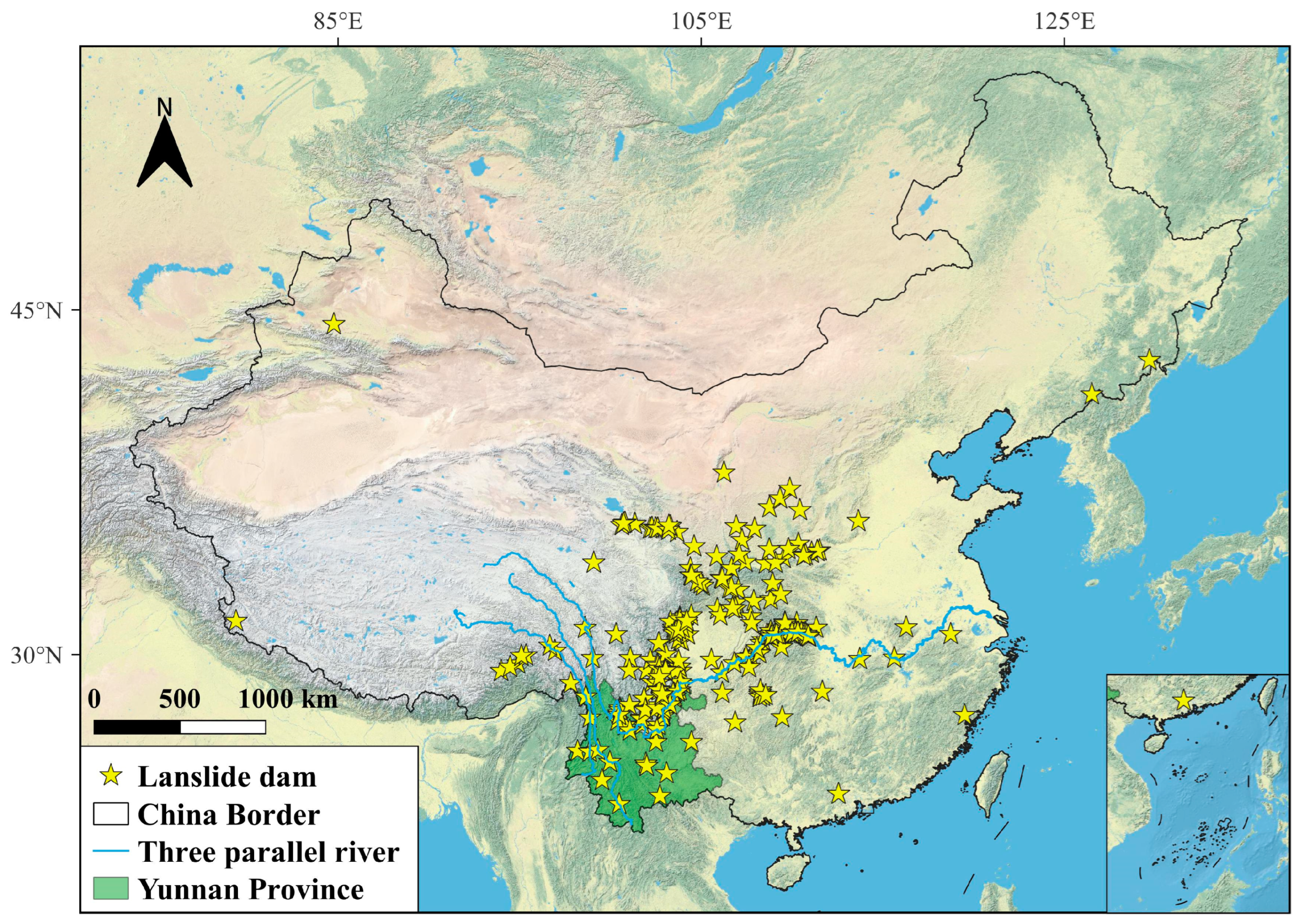
:1. Introduction
2. Materials and Methods
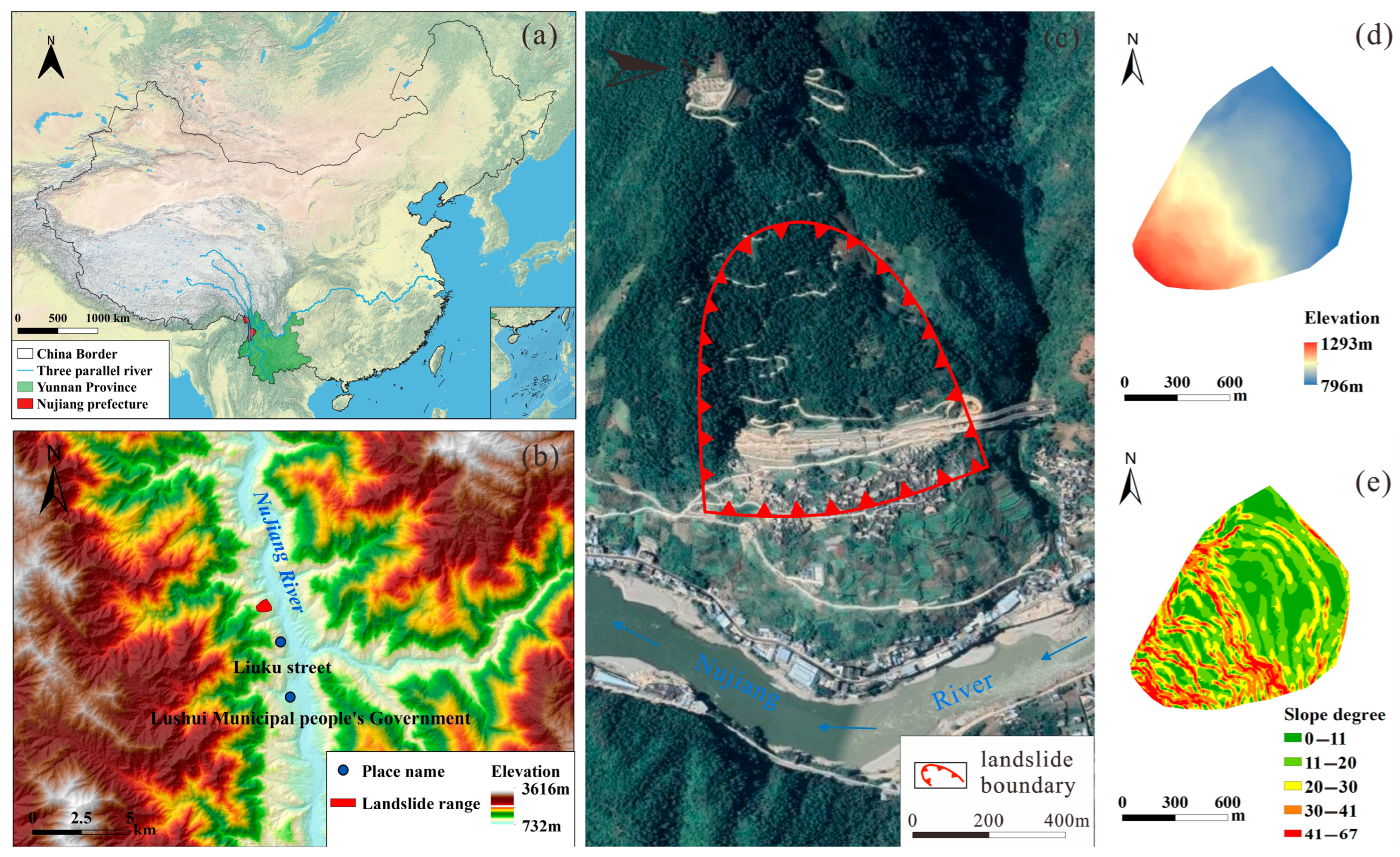
2.1. Overview of the Zhuangfang Landslide
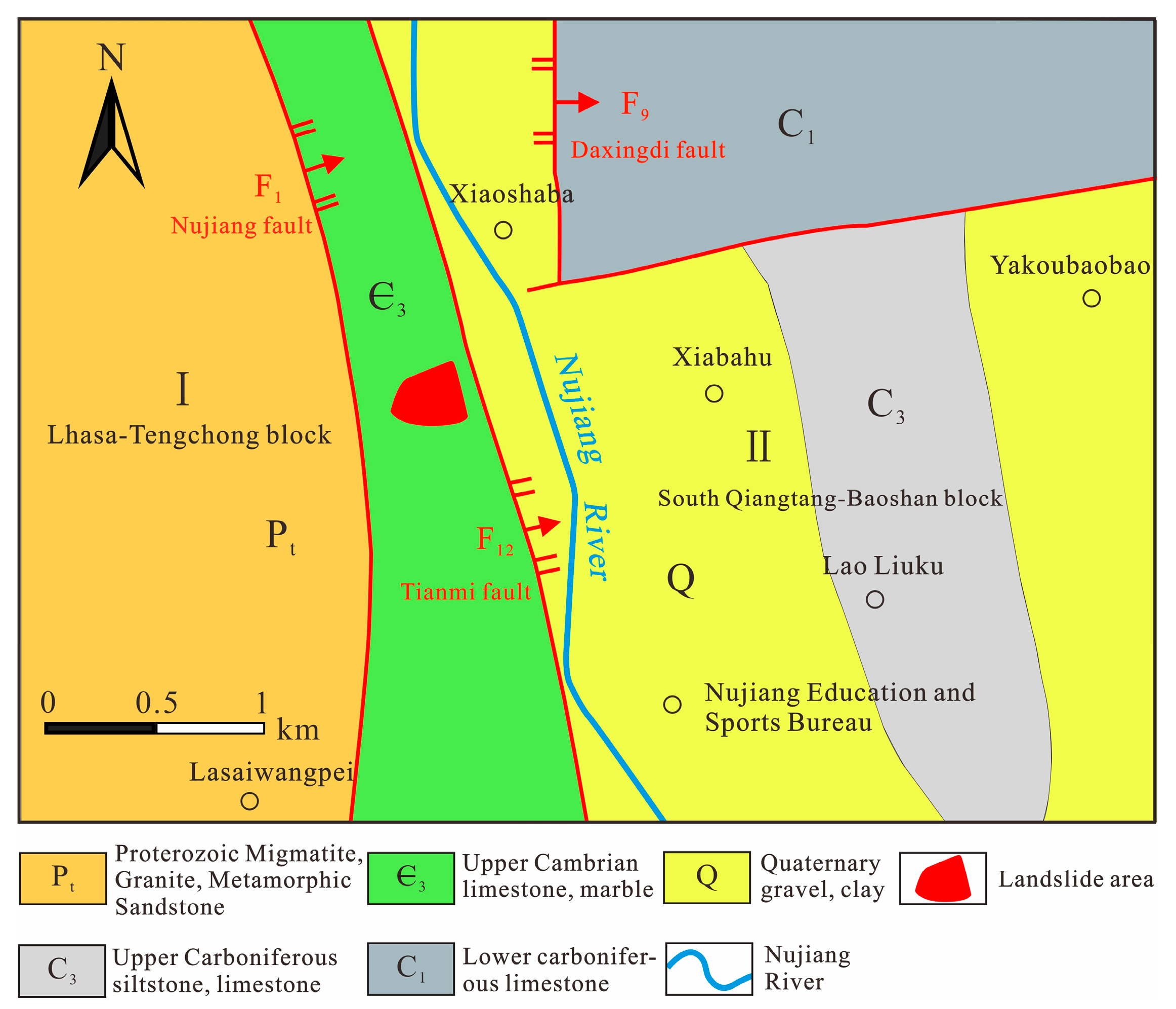
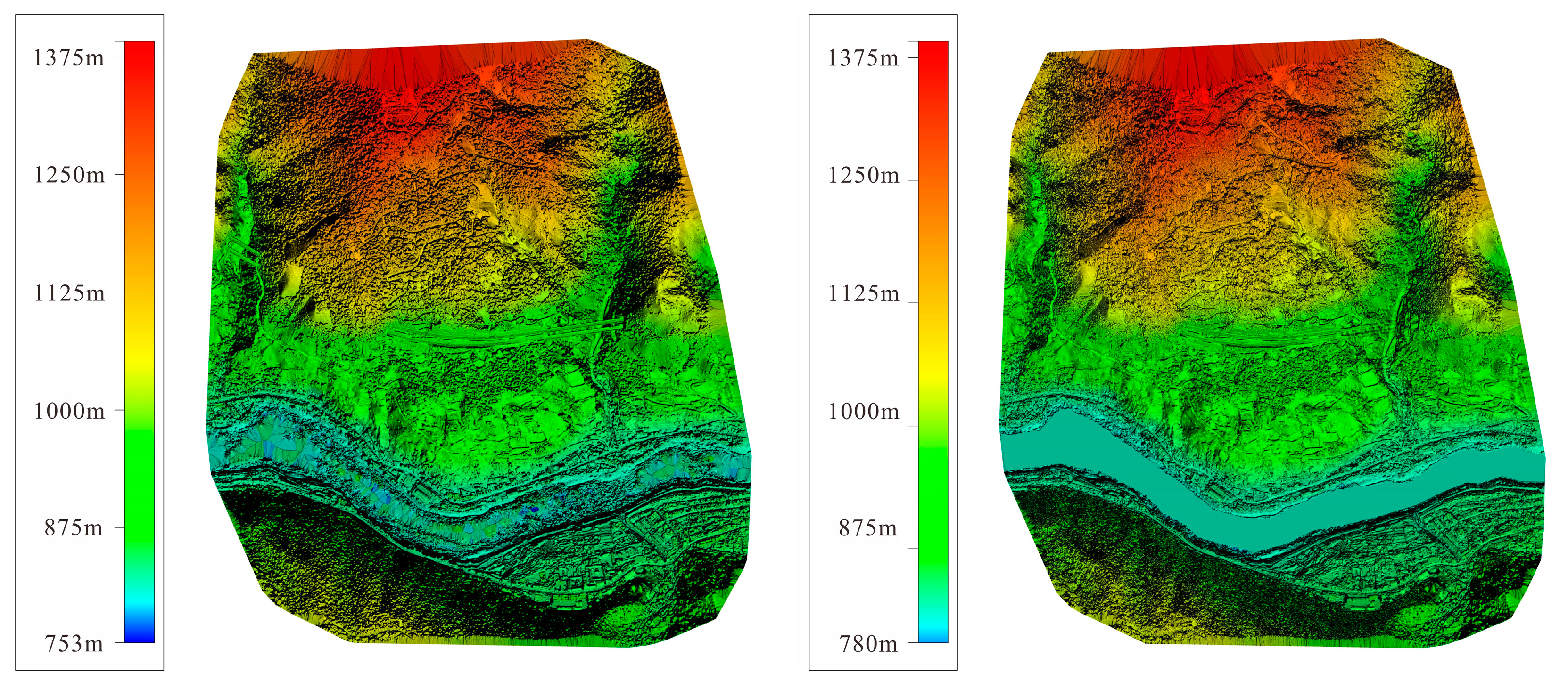
2.1.1. Background of the Landslide Area
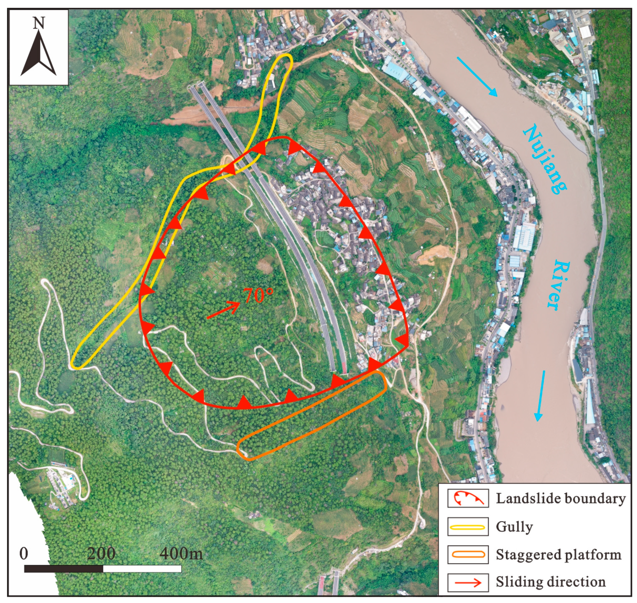
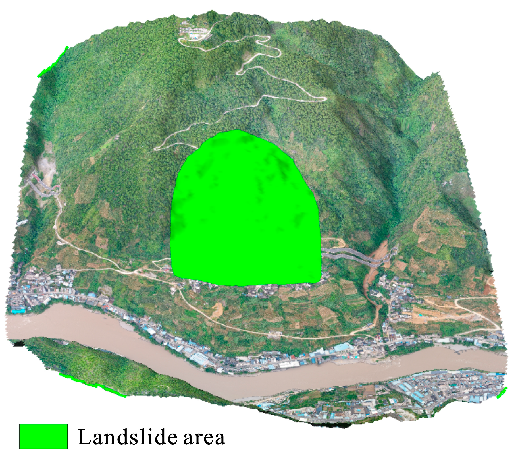
2.1.2. Landslide Details
2.1.3. Stratum Structure
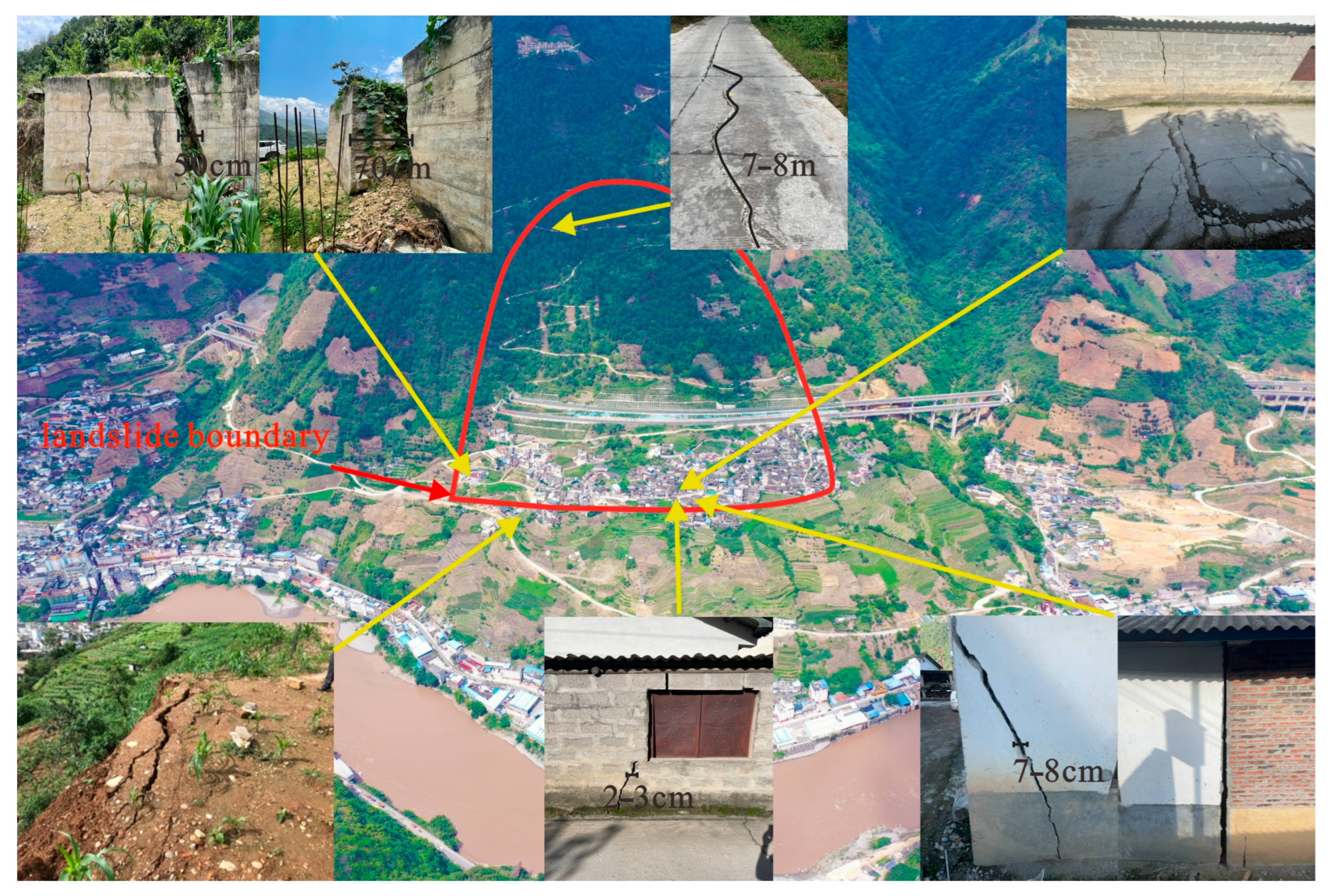
2.1.4. Deformation Characteristics
2.1.5. Stability Analysis
2.2. Prediction and Analysis of Landside Dam Hazard of the Zhuangfang Landslide
2.2.1. Computational Model
2.2.2. Model Establishment
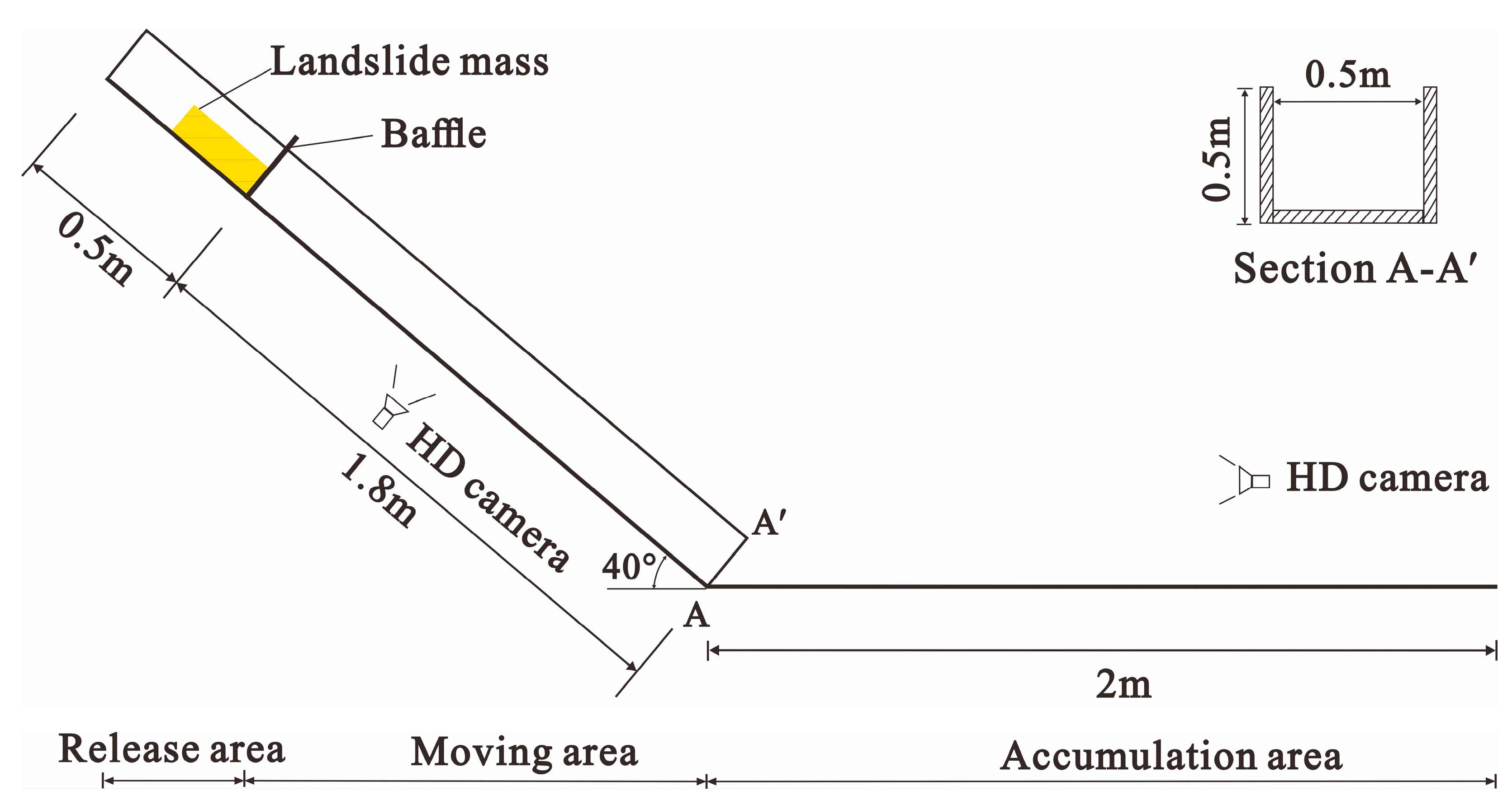
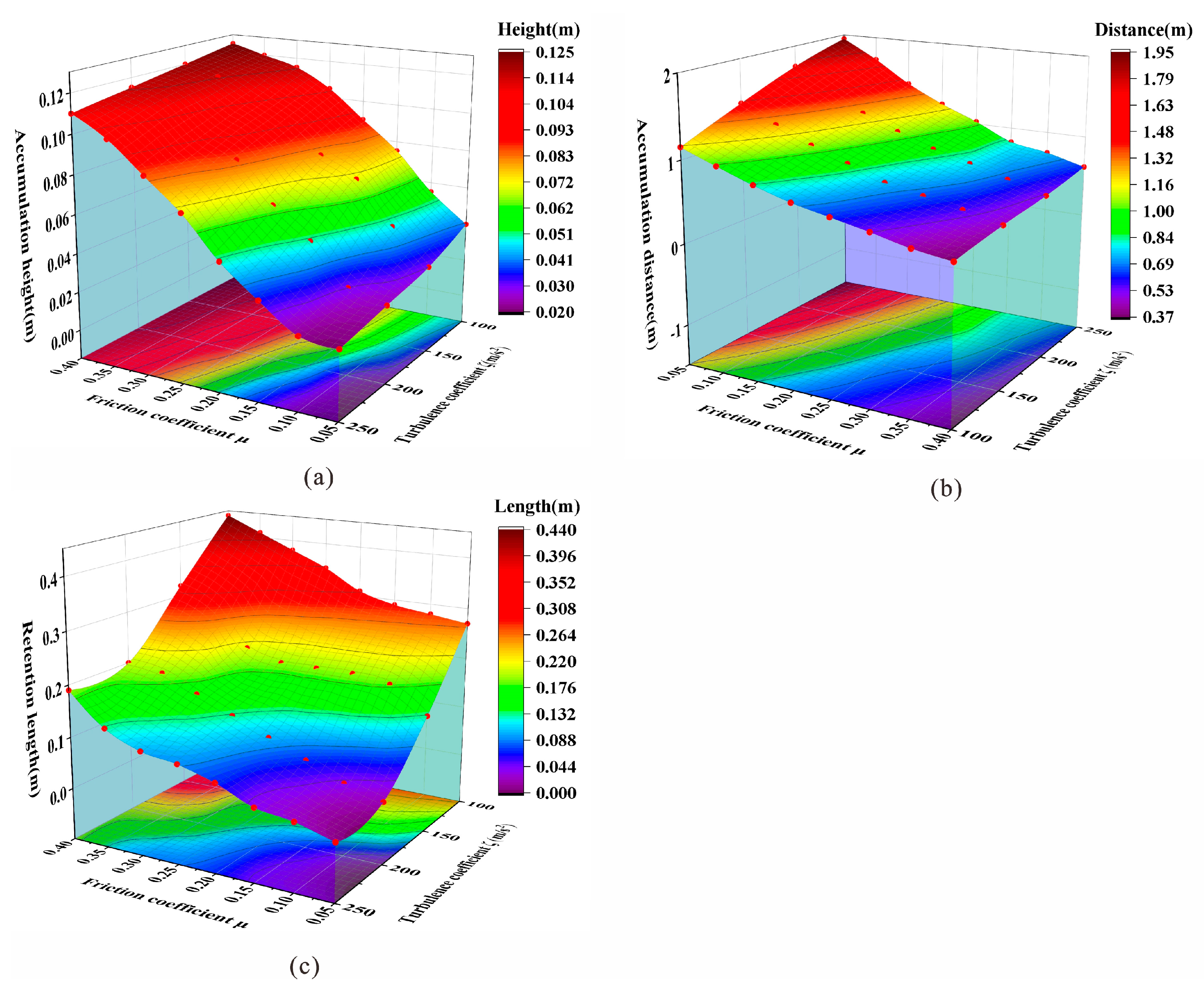
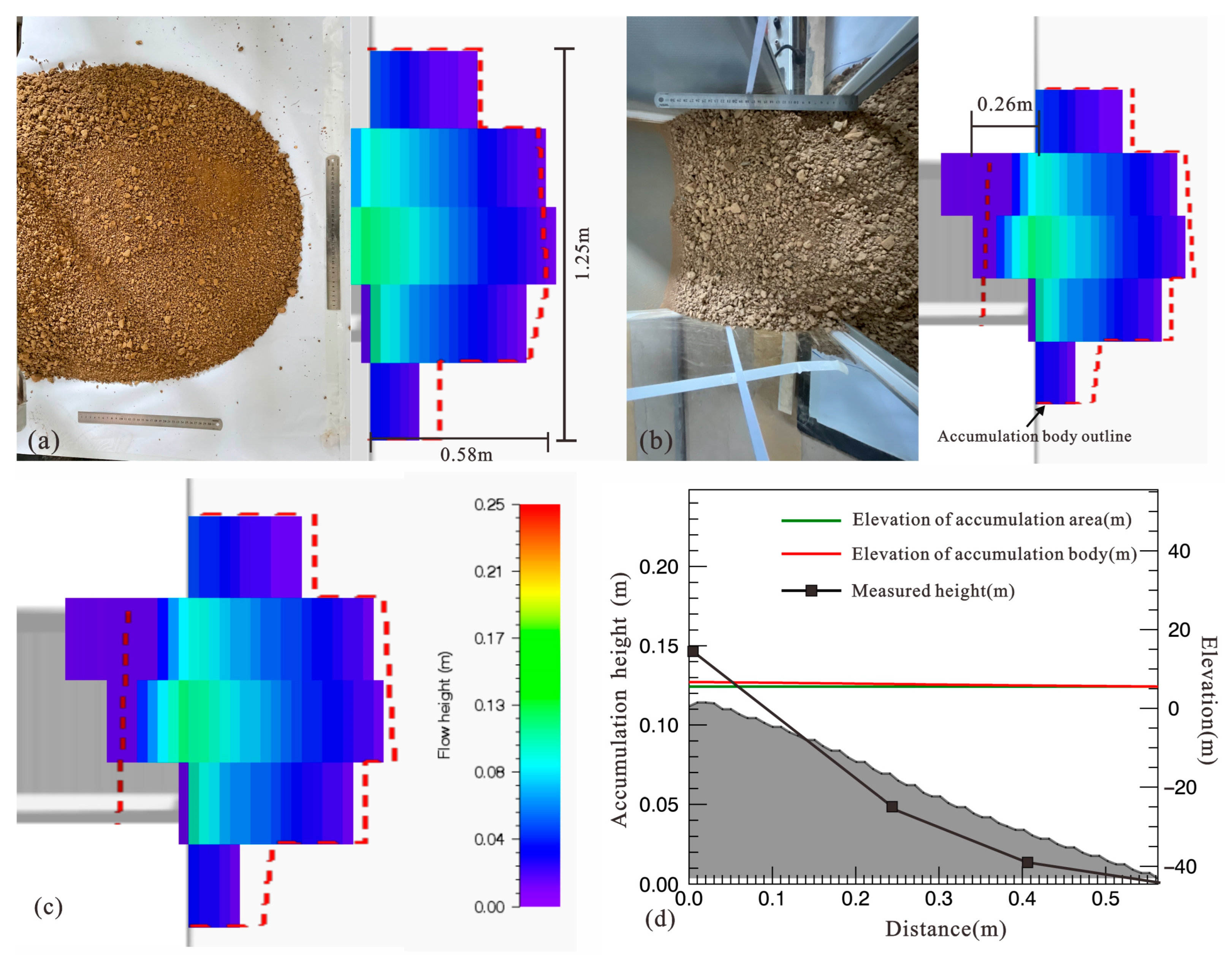
2.2.3. Parameter Calibration
3. Results
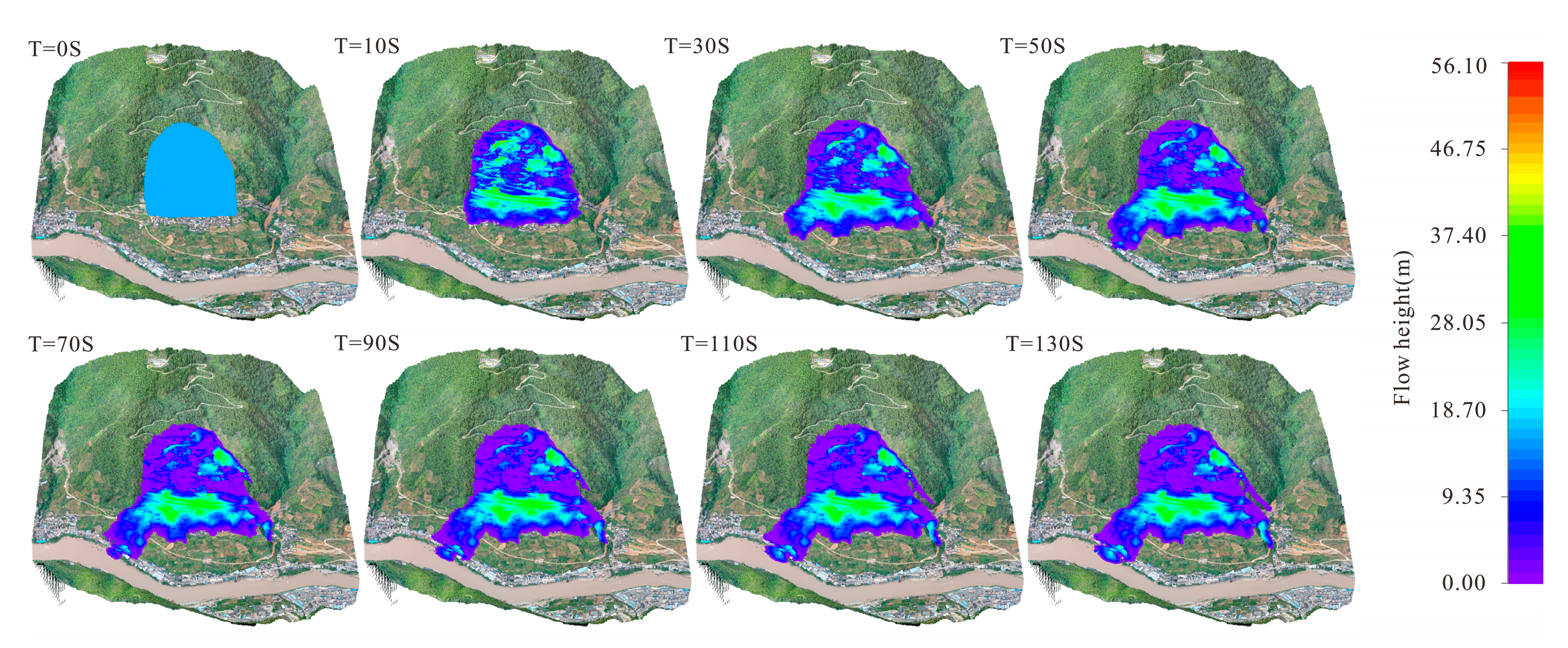
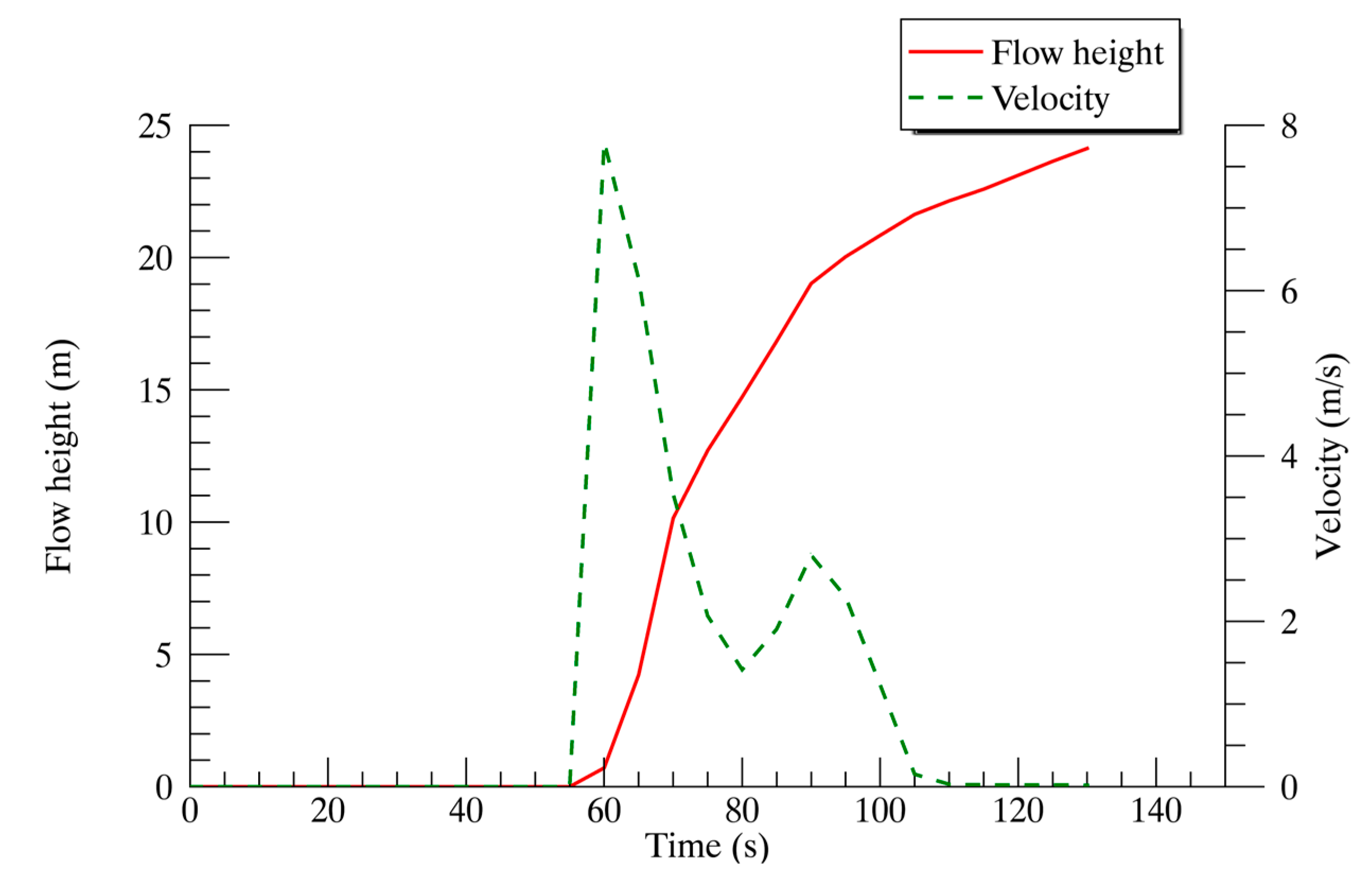
3.1. Landslide Movement Process
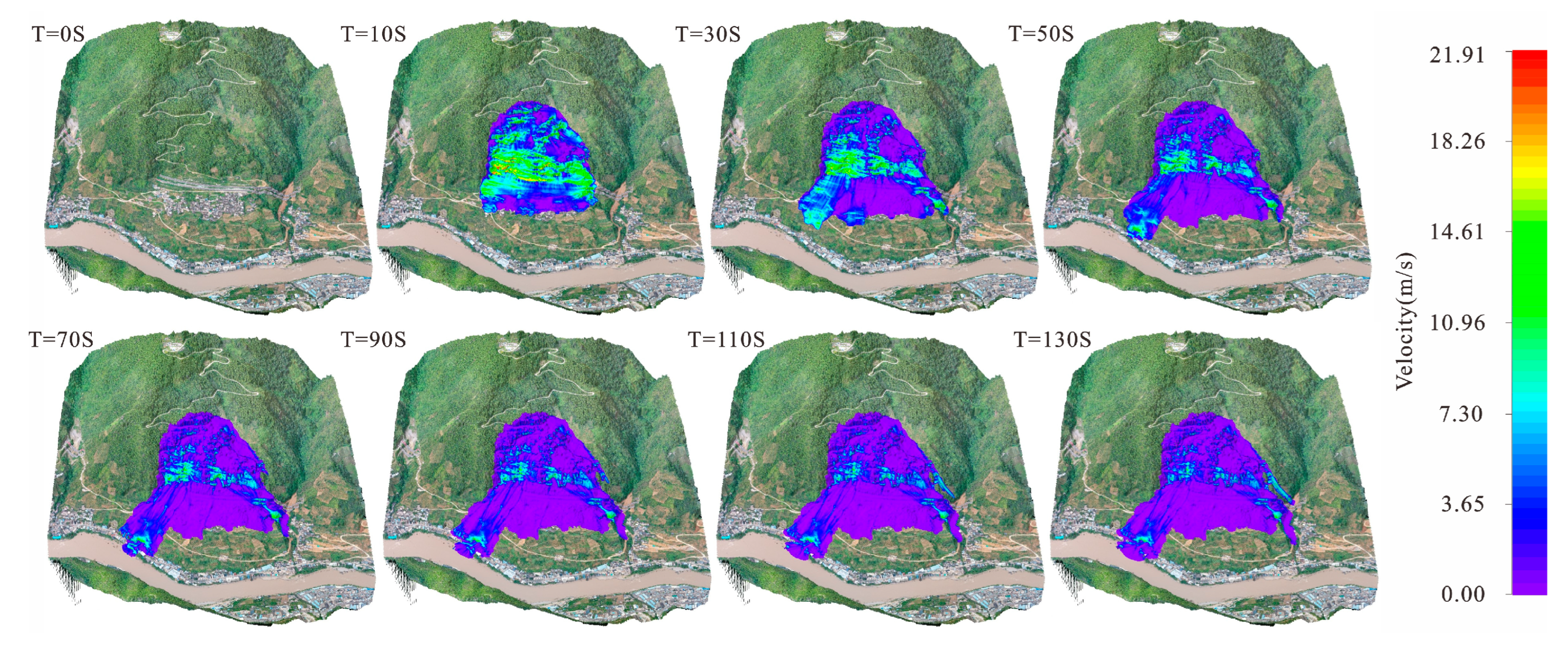
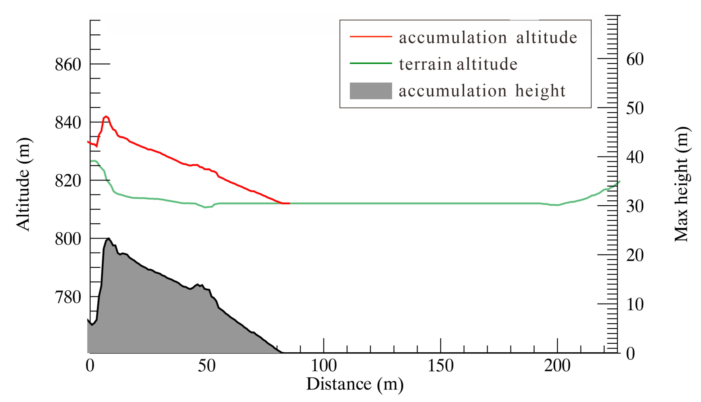
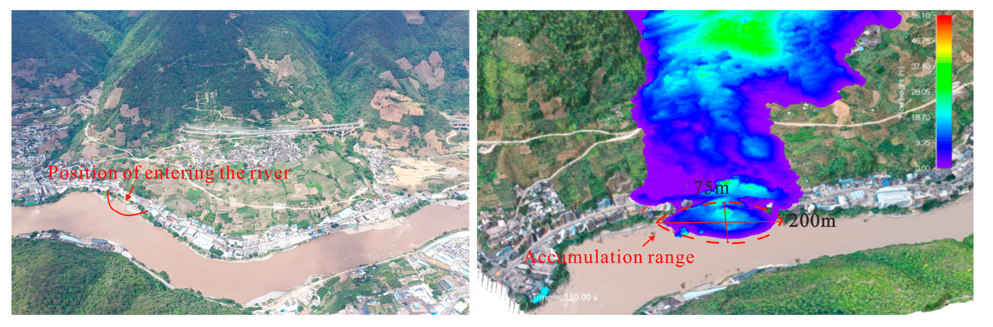
3.2. Characteristics of Entering the River
4. Discussion
4.1. Influencing Factors of Landslide Dam Formation
4.2. Parameter Calibration
5. Conclusions
- (1)
- The Zhuangfang landslide is a large landslide revived from an ancient landslide. The total volume of the landslide is about 4.5 106 m3. The landslide is affected by rainfall and irrigation, and the front edge shows severe signs of deformation. At the same time, according to the calculation results of GEO5 software, the landslide is currently in an under-stable state, and there is a risk of further instability sliding and river blockage.
- (2)
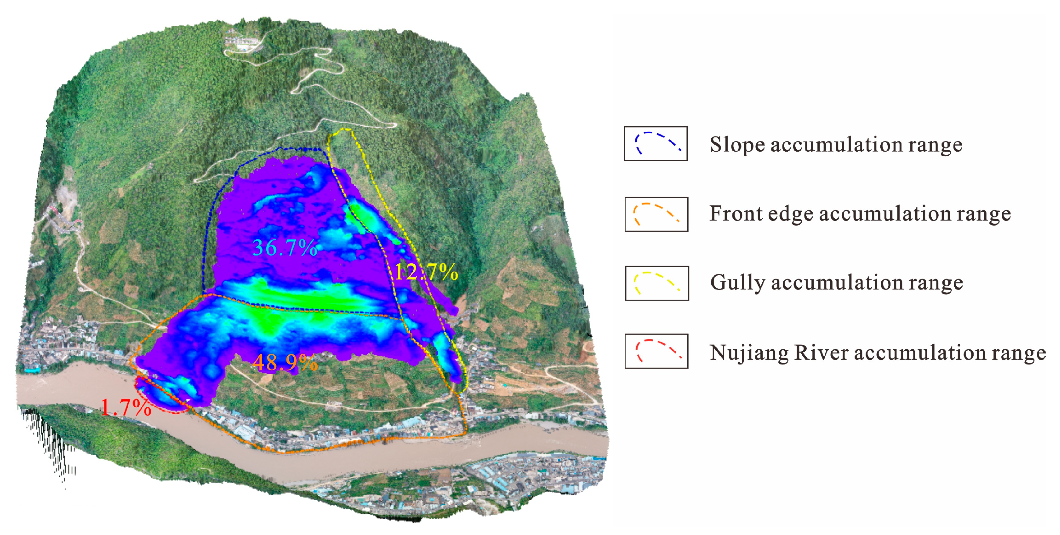
- Through the comparative tests of the designed indoor chute and numerical simulation chute, the accumulation height, accumulation range, and retention length of landslide accumulation under the two groups of tests were compared by the control variable method. The landslide parameters based on the Voellmy-fluid friction model were determined, where the friction coefficient is 0.33 and the turbulence coefficient is 150 m/s2. From the accumulation characteristics of the landslide, the topography significantly impacts the volume of the landslide entering the river. Most of the landslides are completely detained on the slope, and only a small part of the landslides flow into the Nu River, accounting for only 1.7% of the total volume of the landslide. From the numerical simulation results, the landslide entering the Nu River has not completely blocked the river. Thus, the Zhuangfang landslide cannot form a dam to block the river. However, because some landslides still enter the Nu River, the landslides will not completely block the river, causing river sand siltation and river diversion, leading to water pollution, fish reduction, vegetation destruction, and damage to the front disaster-bearing bodies, which is not conducive to the sustainable development of the ecological environment in the basin. It is recommended to carry out timely management of the landslide.
- (3)
- This paper did not consider the impact of the interaction between water and soil on the formation of landslide dams in the numerical simulation. In fact, the impact of the river has a great influence on the formation of landslide dams. How to simulate the coupling between water and soil under high-precision three-dimensional terrain is the main research direction for predicting landslide dam formation in the future. At the same time, in the numerical simulation, the determination of parameters is still a difficult problem. This paper proposes a new idea through the parameter inversion method, but its accuracy still needs more cases to be verified.
Author Contributions
Funding
Institutional Review Board Statement
Informed Consent Statement
Data Availability Statement
Acknowledgments
Conflicts of Interest
References
- Schuster, R.L.; Alford, D. Usoi landslide dam and lake sarez, Pamir mountains, Tajikistan. Environ. Eng. Geosci. 2004, 10, 151–168. [Google Scholar] [CrossRef]
- Crosta, G.; Chen, H.; Lee, C. Replay of the 1987 Val Pola landslide, Italian alps. Geomorphology 2004, 60, 127–146. [Google Scholar] [CrossRef]
- Dunning, S.; Rosser, N.; Petley, D.; Massey, C. Formation and failure of the Tsatichhu landslide dam, Bhutan. Landslides 2006, 3, 107–113. [Google Scholar] [CrossRef]
- Xu, Q.; Fan, X.-M.; Huang, R.-Q.; Westen, C.V. Landslide dams triggered by the Wenchuan Earthquake, Sichuan Province, south west China. Bull. Eng. Geol. Environ. 2009, 68, 373–386. [Google Scholar] [CrossRef]
- Xu, Q.; Zheng, G.; Li, W.L.; He, Z.Y.; Dong, X.J.; Guo, C.; Feng, W.K. Study on successive landslide damming events of Jinsha River in Baige Village on Octorber 11 and November 3, 2018. J. Eng. Geol. 2018, 26, 1534–1551. [Google Scholar] [CrossRef]
- Chen, K.T.; Kuo, Y.S.; Shieh, C.L. Rapid geometry analysis for earthquake-induced and rainfall-induced landslide dams in Taiwan. J. Mt. Sci. 2014, 11, 360–370. [Google Scholar] [CrossRef]
- Ermini, L.; Casagli, N. Criteria for a preliminary assessment of landslide dam evolution. In Landslides: Proceedings of the First European Conference on Landslides, Prague, Czech Republic, 24–26 June 2002; Rybar, J., Stemberk, J., Wagner, P., Eds.; Routledge: Abingdon, UK, 2018; pp. 157–162. [Google Scholar]
- Cui, P.; Zhu, Y.-Y.; Han, Y.-S.; Chen, X.-Q.; Zhuang, J.-Q. The 12 May Wenchuan earthquake-induced landslide lakes: Distribution and preliminary risk evaluation. Landslides 2009, 6, 209–223. [Google Scholar] [CrossRef]
- Meng, C.K.; Chen, K.T.; Niu, Z.P.; Di, B.F.; Ye, Y.J. Influence of Internal Structure on Breaking Process of Short-Lived Landslide Dams. Front. Earth Sci. 2021, 9, 604635. [Google Scholar] [CrossRef]
- Froehlich, D.C. Predicting Landslide Dam Outburst Flood Peak Discharge. In Geohazard Mitigation: Select Proceedings of VCDRR 2021; Springer: Berlin/Heidelberg, Germany, 2021; pp. 119–132. [Google Scholar]
- Zheng, H.C.; Shi, Z.M.; Shen, D.Y.; Peng, M.; Hanley, K.; Ma, C.Y.; Zhang, L.M. Recent Advances in Stability and Failure Mechanisms of Landslide Dams. Front. Earth Sci. 2021, 9, 659935. [Google Scholar] [CrossRef]
- Mei, S.Y.; Chen, S.S.; Zhong, Q.M.; Shan, Y.B. Effects of Grain Size Distribution on Landslide Dam Breaching-Insights From Recent Cases in China. Front. Earth Sci. 2021, 9, 658578. [Google Scholar] [CrossRef]
- Van Westen, C.J.; Castellanos, E.; Kuriakose, S.L. Spatial data for landslide susceptibility, hazard, and vulnerability assessment: An overview. Eng. Geol. 2008, 102, 112–131. [Google Scholar] [CrossRef]
- Fan, X.M.; Rossiter, D.G.; van Westen, C.J.; Xu, Q.; Gorum, T. Empirical prediction of coseismic landslide dam formation. Earth Surf. Process. Landf. 2014, 39, 1913–1926. [Google Scholar] [CrossRef]
- Stefanelli, C.T.; Segoni, S.; Casagli, N.; Catani, F. Geomorphic indexing of landslide dams evolution. Eng. Geol. 2016, 208, 1–10. [Google Scholar] [CrossRef]
- Legros, F. The mobility of long-runout landslides. Eng. Geol. 2002, 63, 301–331. [Google Scholar] [CrossRef]
- Liao, H.M.; Yang, X.G.; Li, H.B.; Gan, B.R.; Zhou, J.W. Increase in hazard from successive landslide-dammed lakes along the Jinsha River, Southwest China. Geomat. Nat. Hazards Risk 2020, 11, 1115–1128. [Google Scholar] [CrossRef]
- Chen, C.Y.; Chang, J.M. Landslide dam formation susceptibility analysis based on geomorphic features. Landslides 2016, 13, 1019–1033. [Google Scholar] [CrossRef]
- Liao, H.M.; Yang, X.G.; Lu, G.D.; Tao, J.; Zhou, J.W. Experimental study on the river blockage and landslide dam formation induced by rock slides. Eng. Geol. 2019, 261, 105269. [Google Scholar] [CrossRef]
- Liao, H.-M.; Yang, X.-G.; Lu, G.-D.; Tao, J.; Zhou, J.-W. Experimental study on the formation of landslide dams by fragmentary materials from successive rock slides. Bull. Eng. Geol. Environ. 2020, 79, 1591–1604. [Google Scholar] [CrossRef]
- Nian, T.K.; Wu, H.; Li, D.Y.; Zhao, W.; Takara, K.; Zheng, D.F. Experimental investigation on the formation process of landslide dams and a criterion of river blockage. Landslides 2020, 17, 2547–2562. [Google Scholar] [CrossRef]
- Zhou, Y.Y.; Shi, Z.M.; Zhang, Q.Z.; Jang, B.A.; Wu, C.Z. Damming process and characteristics of landslide-debris avalanches. Soil Dyn. Earthq. Eng. 2019, 121, 252–261. [Google Scholar] [CrossRef]
- Jiang, M.J.; Shen, Z.F.; Wu, D. CFD-DEM simulation of submarine landslide triggered by seismic loading in methane hydrate rich zone. Landslides 2018, 15, 2227–2241. [Google Scholar] [CrossRef]
- Li, X.Y.; Zhao, J.D. Dam-break of mixtures consisting of non-Newtonian liquids and granular particles. Powder Technol. 2018, 338, 493–505. [Google Scholar] [CrossRef]
- Nian, T.K.; Wu, H.; Takara, K.; Li, D.Y.; Zhang, Y.J. Numerical investigation on the evolution of landslide-induced river blocking using coupled DEM-CFD. Comput. Geotech. 2021, 134, 104101. [Google Scholar] [CrossRef]
- Bao, Y.D.; Sun, X.H.; Zhou, X.; Zhang, Y.S.; Liu, Y.W. Some numerical approaches for landslide river blocking: Introduction, simulation, and discussion. Landslides 2021, 18, 3907–3922. [Google Scholar] [CrossRef]
- Zhao, S.Y.; He, Z.L.; Deng, J.H.; Li, H.; Dai, F.C.; Gao, Y.J.; Chen, F. Giant river-blocking landslide dams with multiple failure sources in the Nu River and the impact on transient landscape evolution in southeastern Tibet. Geomorphology 2022, 413, 108357. [Google Scholar] [CrossRef]
- Jia, H.; Chen, F.; Pan, D. Disaster Chain Analysis of Avalanche and Landslide and the River Blocking Dam of the Yarlung Zangbo River in Milin County of Tibet on 17 and 29 October 2018. Int. J. Environ. Res. Public Health 2019, 16, 4707. [Google Scholar] [CrossRef]
- Safran, E.B.; O’Connor, J.E.; Ely, L.L.; House, P.K.; Grant, G.; Harrity, K.; Croall, K.; Jones, E. Plugs or flood-makers? The unstable landslide dams of eastern Oregon. Geomorphology 2015, 248, 237–251. [Google Scholar] [CrossRef]
- Feng, Z.Y. The seismic signatures of the surge wave from the 2009 Xiaolin landslide-dam breach in Taiwan. Hydrol. Process. 2012, 26, 1342–1351. [Google Scholar] [CrossRef]
- Strom, A. Natural river damming: Climate-driven or seismically induced phenomena: Basics for landslide and seismic hazard assessment. In Proceedings of the Engineering Geology for Society and Territory-Volume 2: Landslide Processes; 2015; pp. 33–41. [Google Scholar]
- GB/T 32864-2016; Code for Geological Investigation of Landslide Prevention. Standards Press of China: Beijing, China, 2016.
- Zhang, T.T.; Yin, Y.P.; Li, B.; Liu, X.J.; Wang, M.; Gao, Y.; Wan, J.W.; Gnyawali, K.R. Characteristics and dynamic analysis of the February 2021 long-runout disaster chain triggered by massive rock and ice avalanche at Chamoli, Indian Himalaya. J. Rock Mech. Geotech. Eng. 2023, 15, 296–308. [Google Scholar] [CrossRef]
- Zhou, J.W.; Huang, K.X.; Shi, C.; Hao, M.H.; Guo, C.X. Discrete element modeling of the mass movement and loose material supplying the gully process of a debris avalanche in the Bayi Gully, Southwest China. J. Asian Earth Sci. 2015, 99, 95–111. [Google Scholar] [CrossRef]
- Ouyang, C.J.; Zhao, W.; Xu, Q.; Peng, D.L.; Li, W.L.; Wang, D.P.; Zhou, S.; Hou, S.W. Failure mechanisms and characteristics of the 2016 catastrophic rockslide at Su village, Lishui, China. Landslides 2018, 15, 1391–1400. [Google Scholar] [CrossRef]
- Charrière, M.; Humair, F.; Froese, C.; Jaboyedoff, M.; Pedrazzini, A.; Longchamp, C. From the source area to the deposit: Collapse, fragmentation, and propagation of the Frank Slide. Bulletin 2016, 128, 332–351. [Google Scholar] [CrossRef]
- Zheng, H.C.; Shi, Z.M.; Peng, M.; Zhou, Y.Y. Review and prospect of the formation mechanism of landslide dams caused by landslide and avalanche debris. Adv. Eng. Sci. 2020, 52, 2. [Google Scholar] [CrossRef]
- De Blasio, F.V.; Crosta, G.B. Simple physical model for the fragmentation of rock avalanches. Acta Mech. 2014, 225, 243–252. [Google Scholar] [CrossRef]
- Locat, P.; Couture, R.; Leroueil, S.; Locat, J.; Jaboyedoff, M. Fragmentation energy in rock avalanches. Can. Geotech. J. 2006, 43, 830–851. [Google Scholar] [CrossRef]
- Kong, J.X.; Zhuang, J.Q.; Zhan, J.W.; Bai, Z.W.; Leng, Y.Q.; Ma, P.H.; Peng, J.B.; Wang, Z.P.; Gu, T.F.; Sun, J.X.; et al. A landslide in Heifangtai, northwest of the Chinese Loess Plateau: Triggered factors, movement characteristics, and failure mechanism. Landslides 2021, 18, 3407–3419. [Google Scholar] [CrossRef]
- Mikoš, M.; Bezak, N. Debris Flow Modelling Using RAMMS Model in the Alpine Environment With Focus on the Model Parameters and Main Characteristics. Front. Earth Sci. 2021, 8, 605061. [Google Scholar] [CrossRef]


| Stratum | Volumetric Weight γ/(kN·m3) | Internal Friction Angle φ/(°) | Cohesion Force c/kPa | |||
|---|---|---|---|---|---|---|
| Natural | Saturation | Natural | Saturation | Natural | Saturation | |
| Landslide mass | 21 | 22 | 36 | 35 | 18 | 15 |
| Slip soil | 21 | 22 | 22 | 20 | 15 | 14 |
| Bedrock | 25 | - | 41 | - | 700 | - |
| Landslide Stability Coefficient (FS) | FS < 1.00 | 1.00 ≤ FS < 1.05 | 1.05 ≤ FS < 1.15 | FS ≥ 1.15 |
|---|---|---|---|---|
| Landslide stable state | unstable | Under-stable | Basically stable | stable |
| Calculation Conditions | Morgenstern–Price Method | Spencer Method | Janbu Method | |||
|---|---|---|---|---|---|---|
| Stability Coefficient | Stable State | Stability Coefficient | Stable State | Stability Coefficient | Stable State | |
| Natural | 1.12 | Basically stable | 1.13 | Basically stable | 1.12 | Basically stable |
| Rainfall | 1.04 | Under-stable | 1.04 | Under-stable | 1.03 | Under-stable |
| Calculation Parameters | Value |
|---|---|
| DEM resolution | 1 m |
| Release zone depth | 15 m |
| Release zone volume | 4,507,214 m3 |
| Friction coefficient | 0.33 |
| Turbulence coefficient | 150 m/s2 |
| Density | 2000 kg/m3 |
| Simulation end time | 1000 s |
| Momentum percentage | 10% |
| Dump step time | 5 s |
Disclaimer/Publisher’s Note: The statements, opinions and data contained in all publications are solely those of the individual author(s) and contributor(s) and not of MDPI and/or the editor(s). MDPI and/or the editor(s) disclaim responsibility for any injury to people or property resulting from any ideas, methods, instructions or products referred to in the content. |
© 2023 by the authors. Licensee MDPI, Basel, Switzerland. This article is an open access article distributed under the terms and conditions of the Creative Commons Attribution (CC BY) license (https://creativecommons.org/licenses/by/4.0/).
Share and Cite
Di, Y.; Wei, Y.; Tan, W.; Xu, Q. Research on Development Characteristics and Landslide Dam Hazard Prediction of Zhuangfang Landslide in the Upper Reaches of the Nu River. Sustainability 2023, 15, 15036. https://doi.org/10.3390/su152015036
Di Y, Wei Y, Tan W, Xu Q. Research on Development Characteristics and Landslide Dam Hazard Prediction of Zhuangfang Landslide in the Upper Reaches of the Nu River. Sustainability. 2023; 15(20):15036. https://doi.org/10.3390/su152015036
Chicago/Turabian StyleDi, Yong, Yunjie Wei, Weijia Tan, and Qiang Xu. 2023. "Research on Development Characteristics and Landslide Dam Hazard Prediction of Zhuangfang Landslide in the Upper Reaches of the Nu River" Sustainability 15, no. 20: 15036. https://doi.org/10.3390/su152015036
APA StyleDi, Y., Wei, Y., Tan, W., & Xu, Q. (2023). Research on Development Characteristics and Landslide Dam Hazard Prediction of Zhuangfang Landslide in the Upper Reaches of the Nu River. Sustainability, 15(20), 15036. https://doi.org/10.3390/su152015036