
Towards a Paradigm Shift on Mapping Muddy Waters with Sentinel-2 Using Machine Learning

 , , ,
, , ,  ,
,  and
and 
Abstract
:1. Introduction
1.1. Impact
1.2. Detection with Remote Sensing
1.3. Annotation in Semantic Segmentation
1.4. Atmospheric Corrections
1.5. Scope of Study
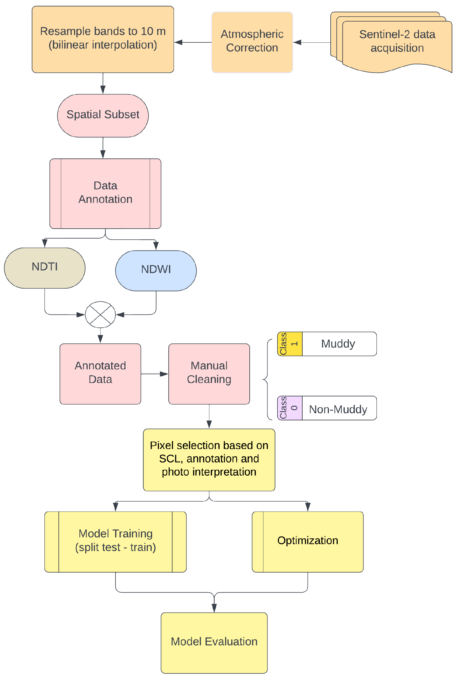
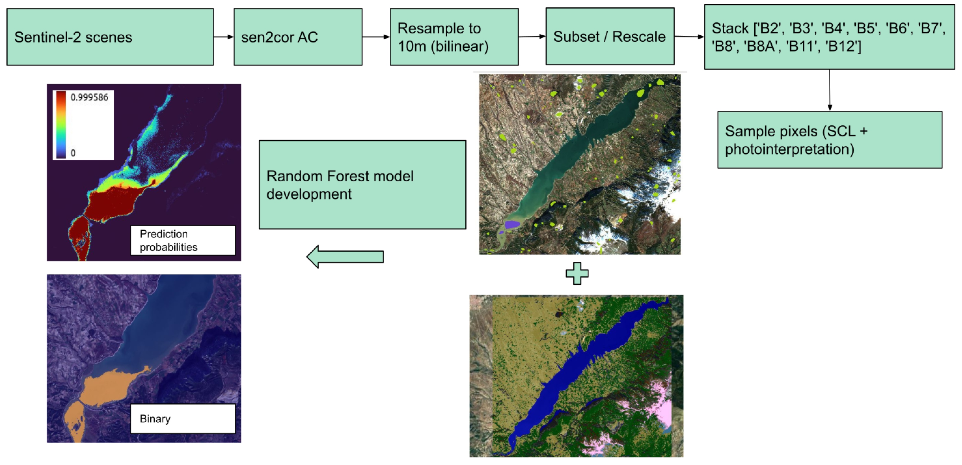
2. Materials and Methods
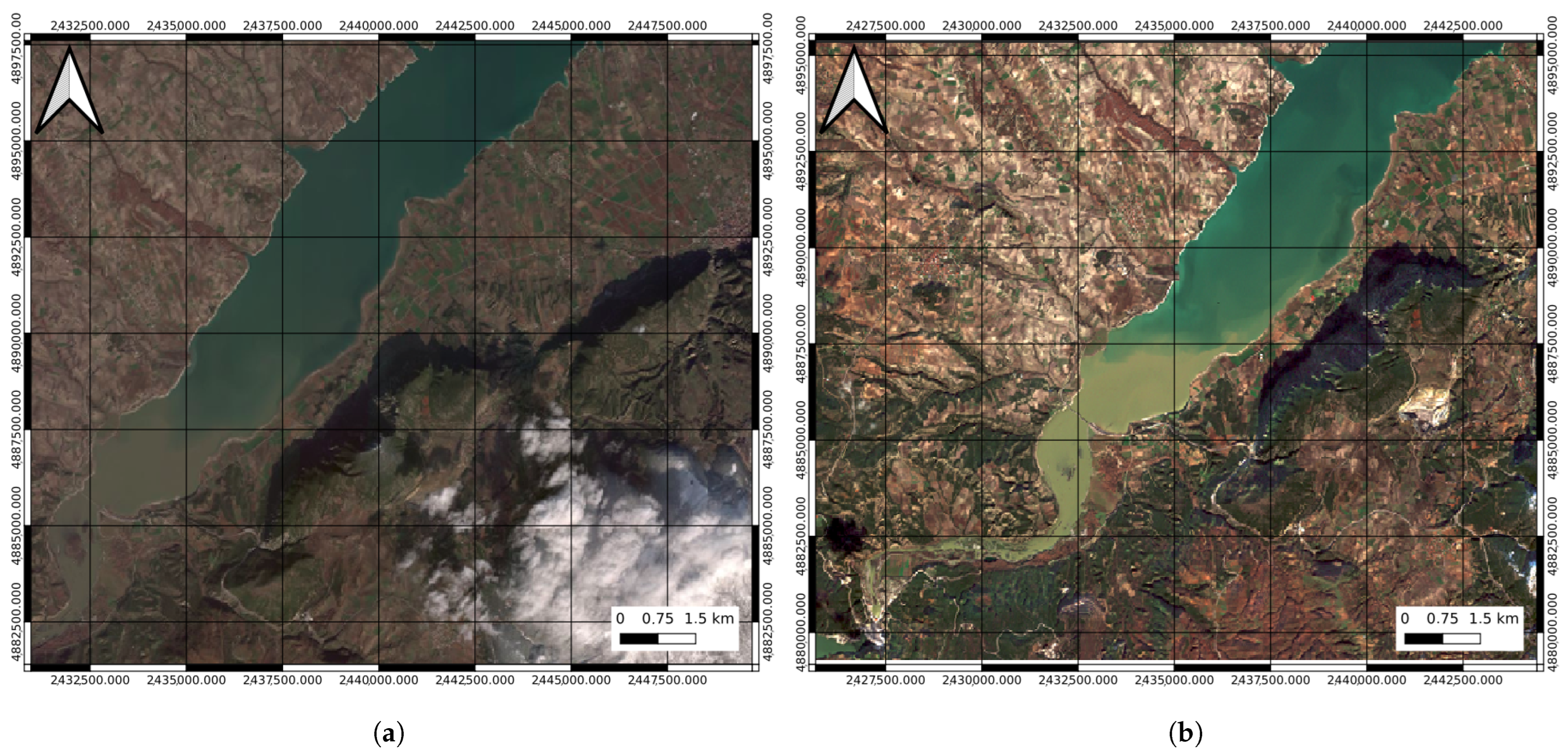
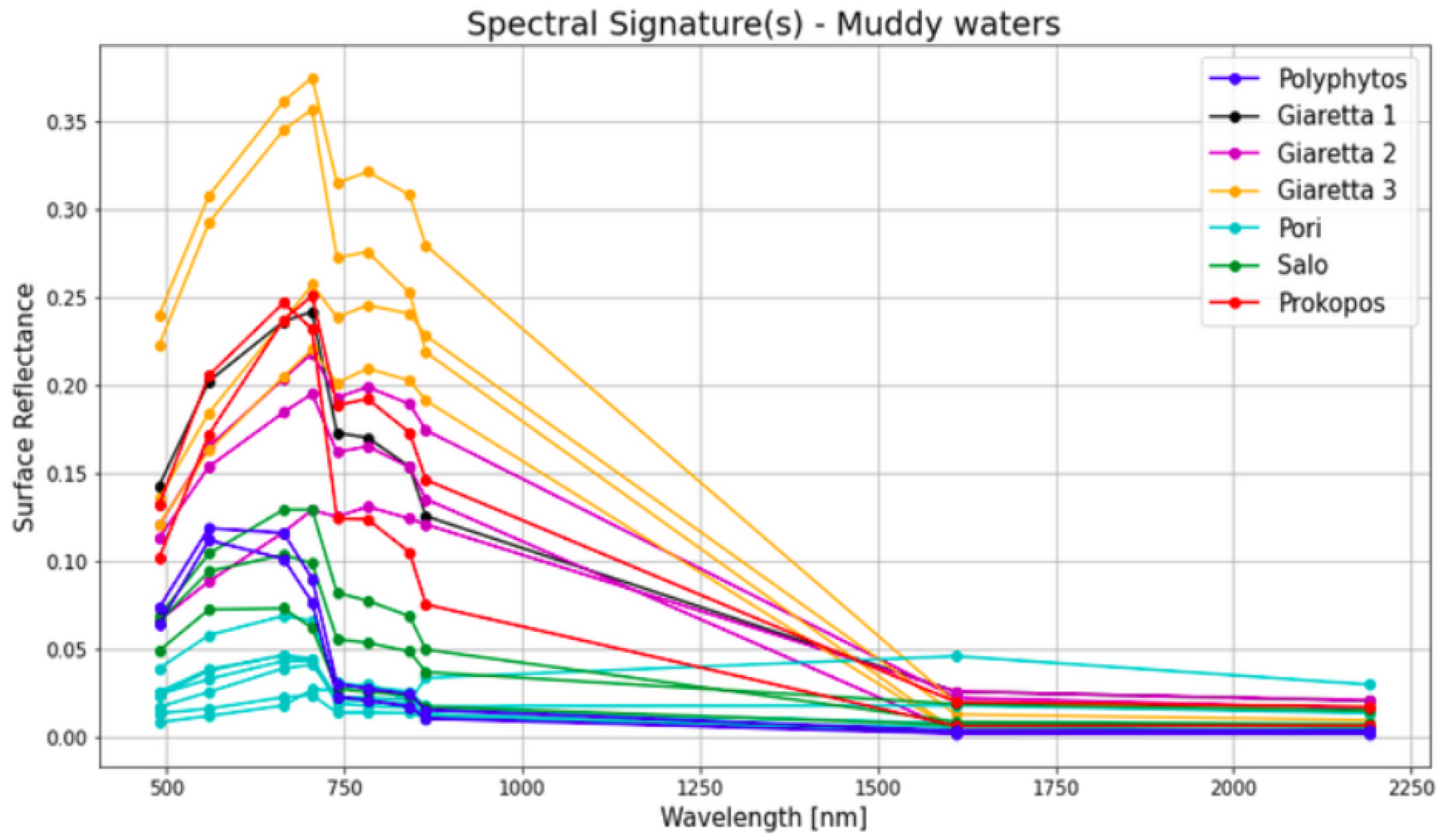
2.1. Selected Areas of Interest
2.2. Data and Pre-Processing
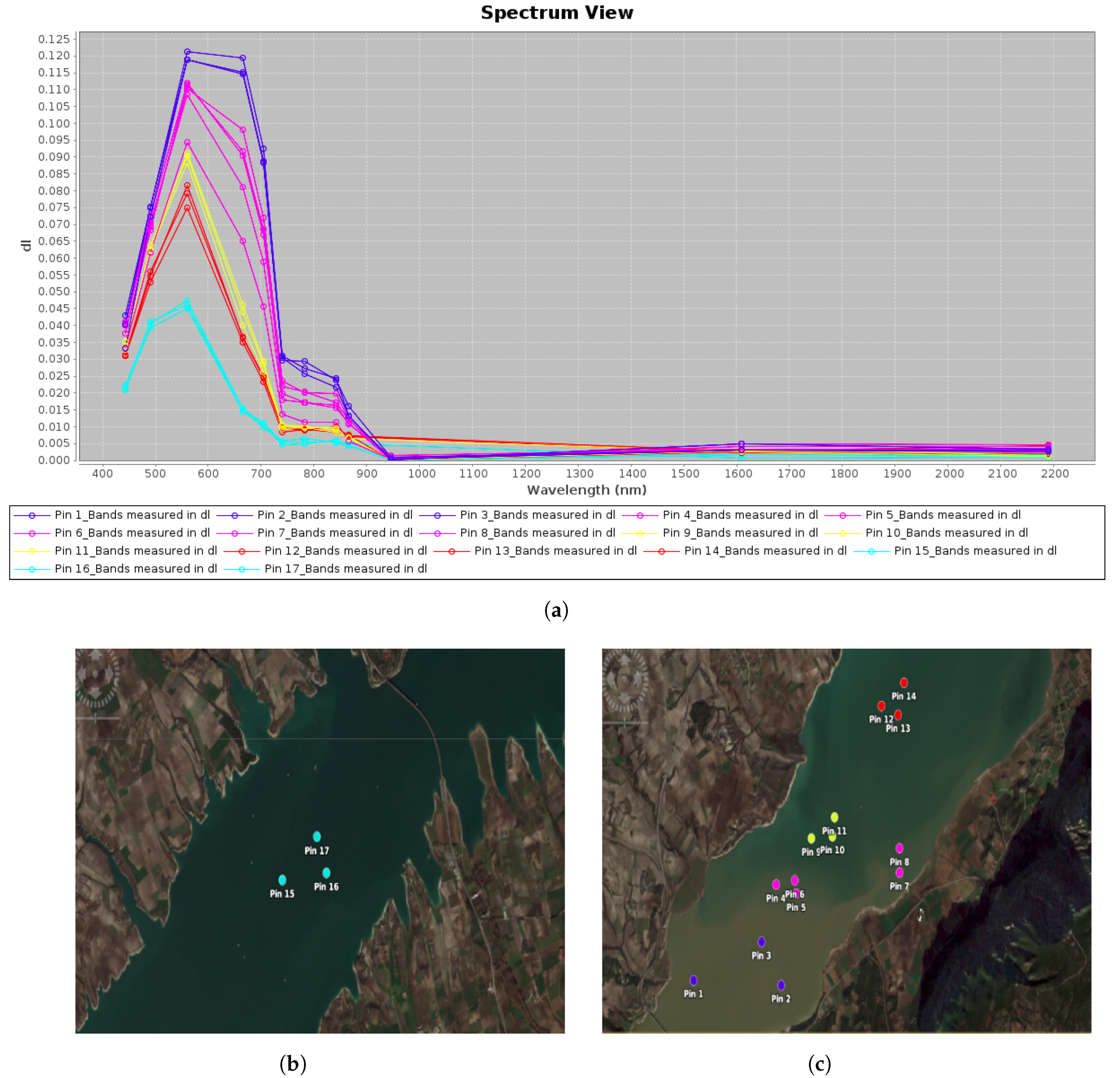
2.3. Data Annotation
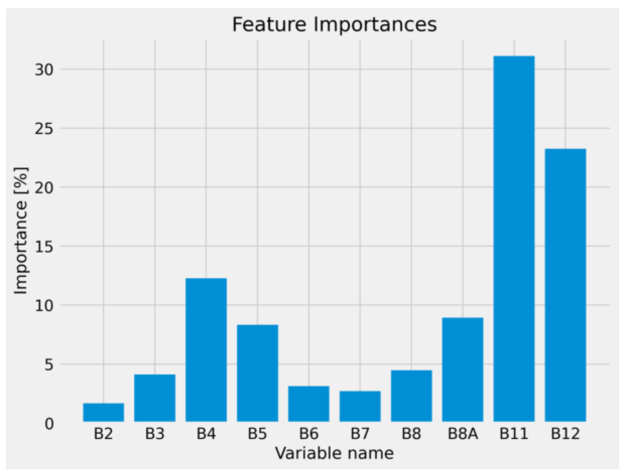
2.4. Model Development
3. Results and Discussion
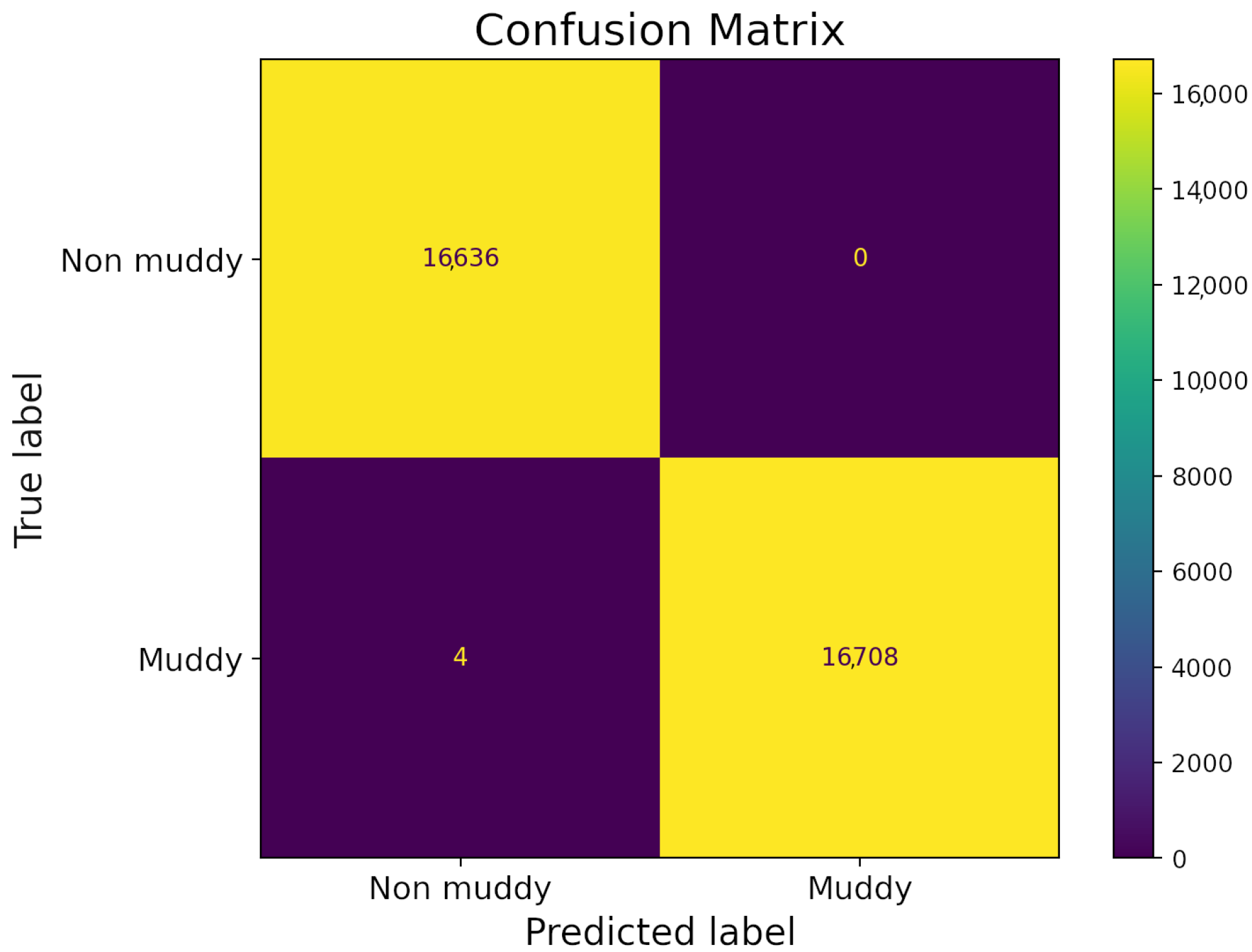
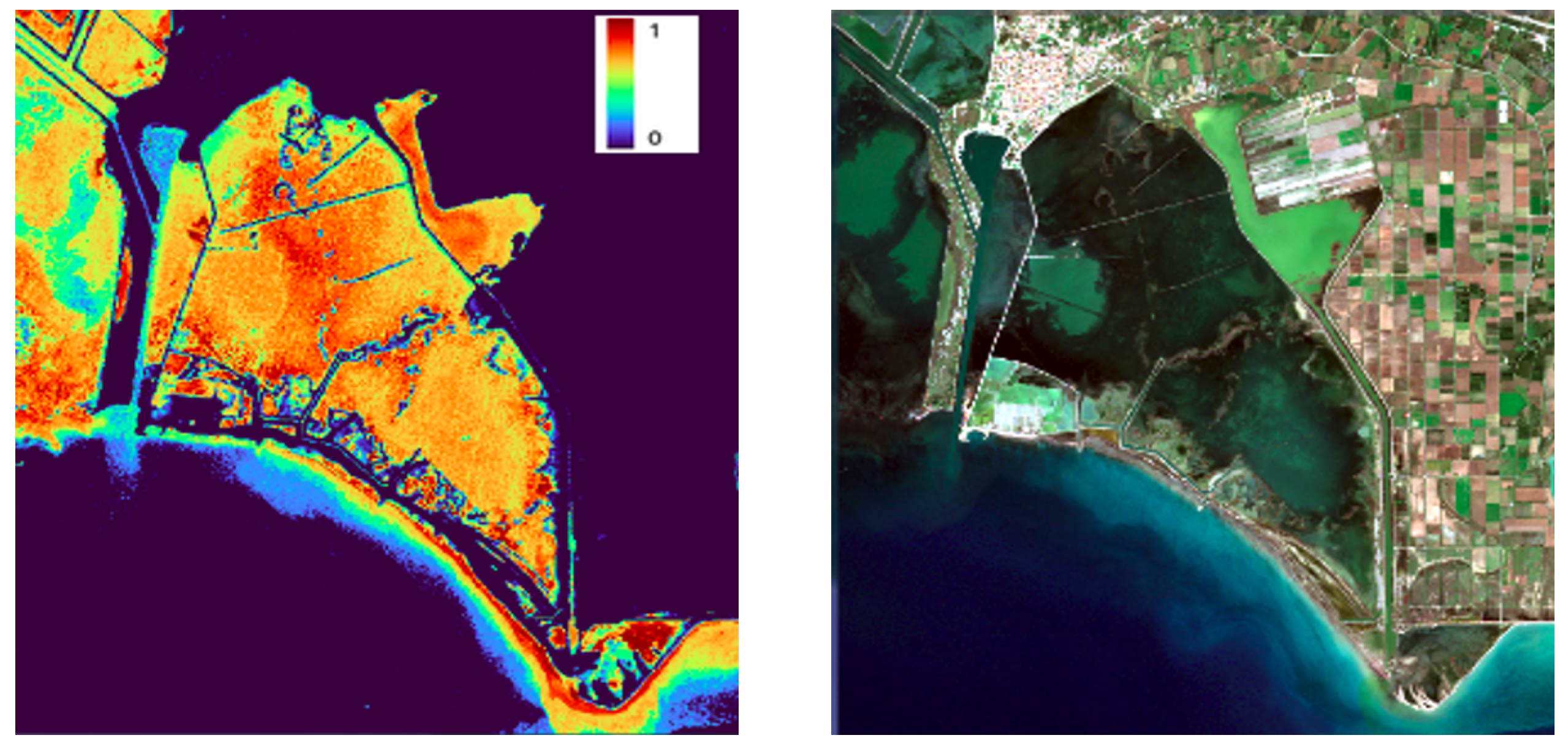
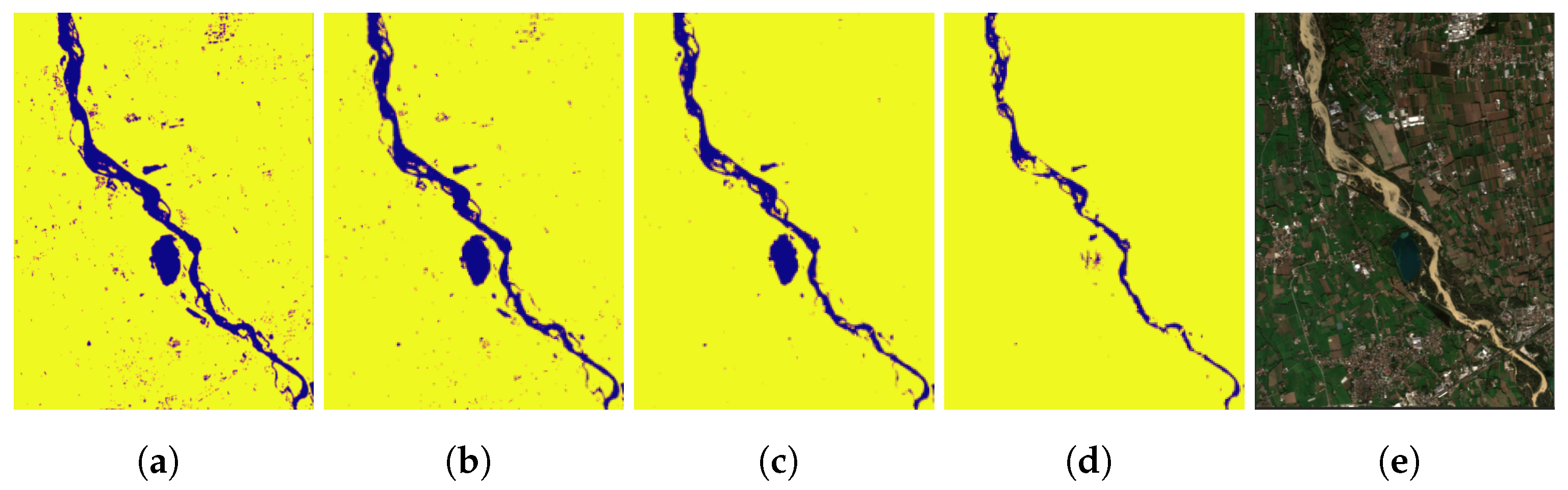
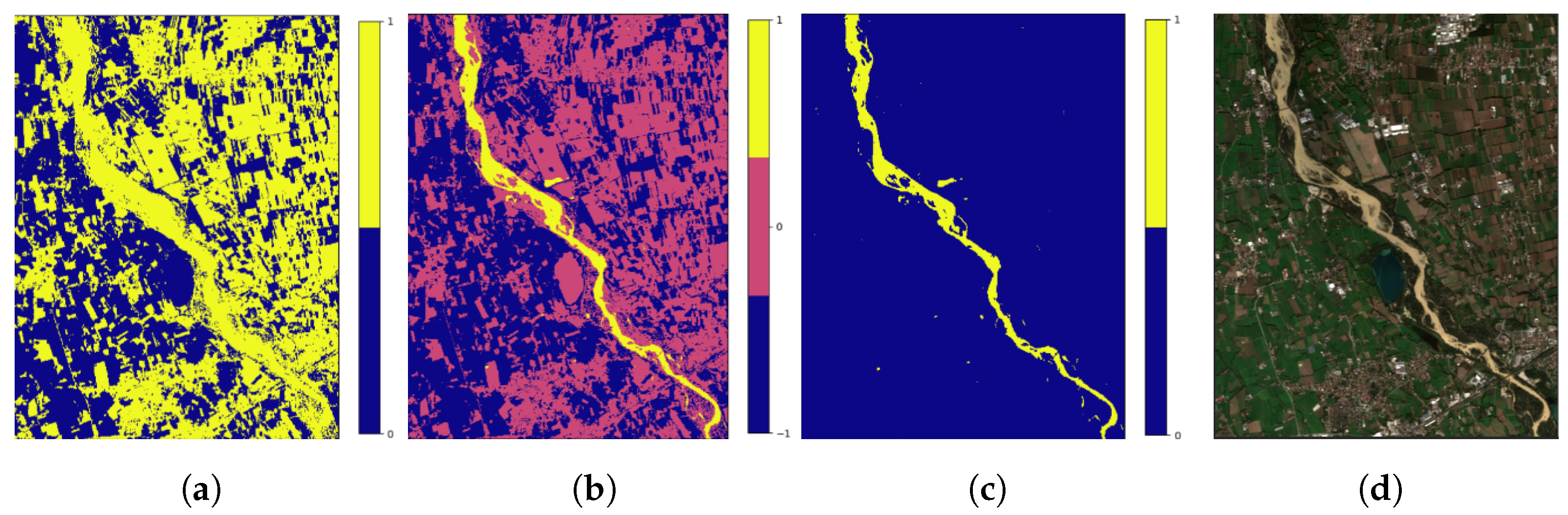
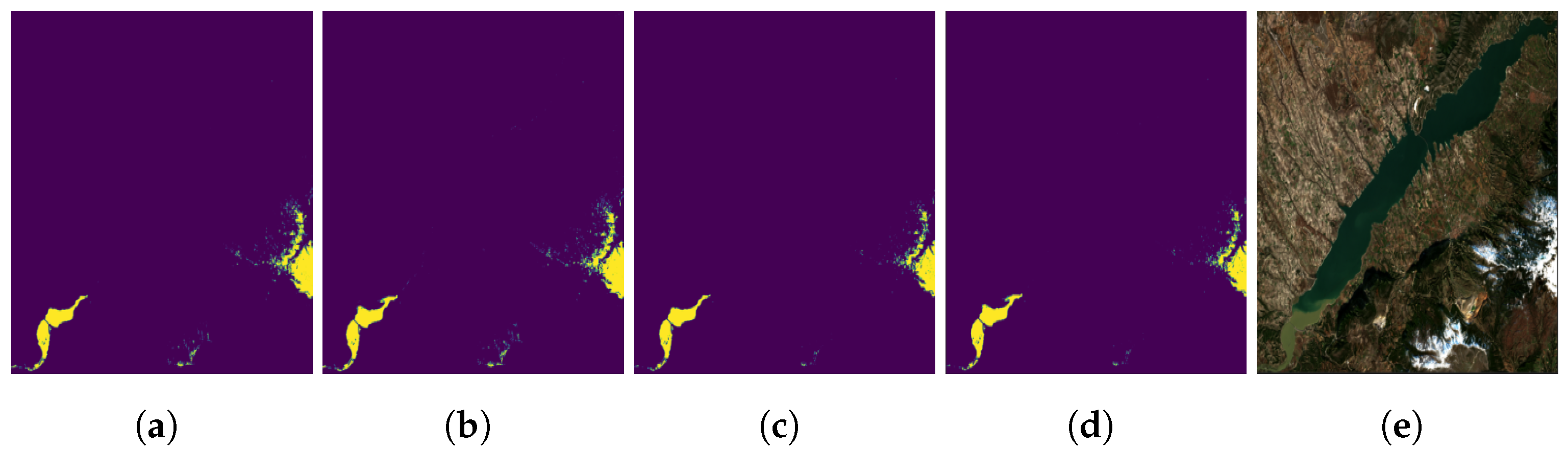
3.1. Model Application and Evaluation
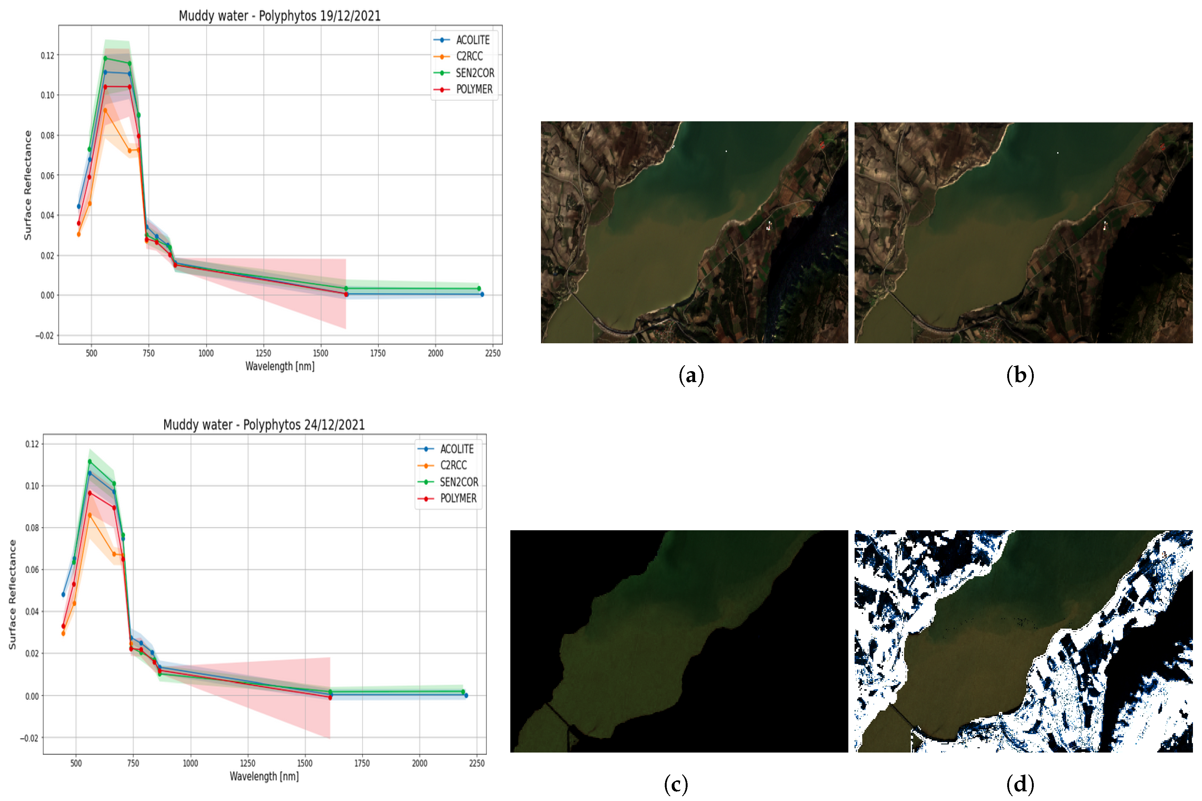
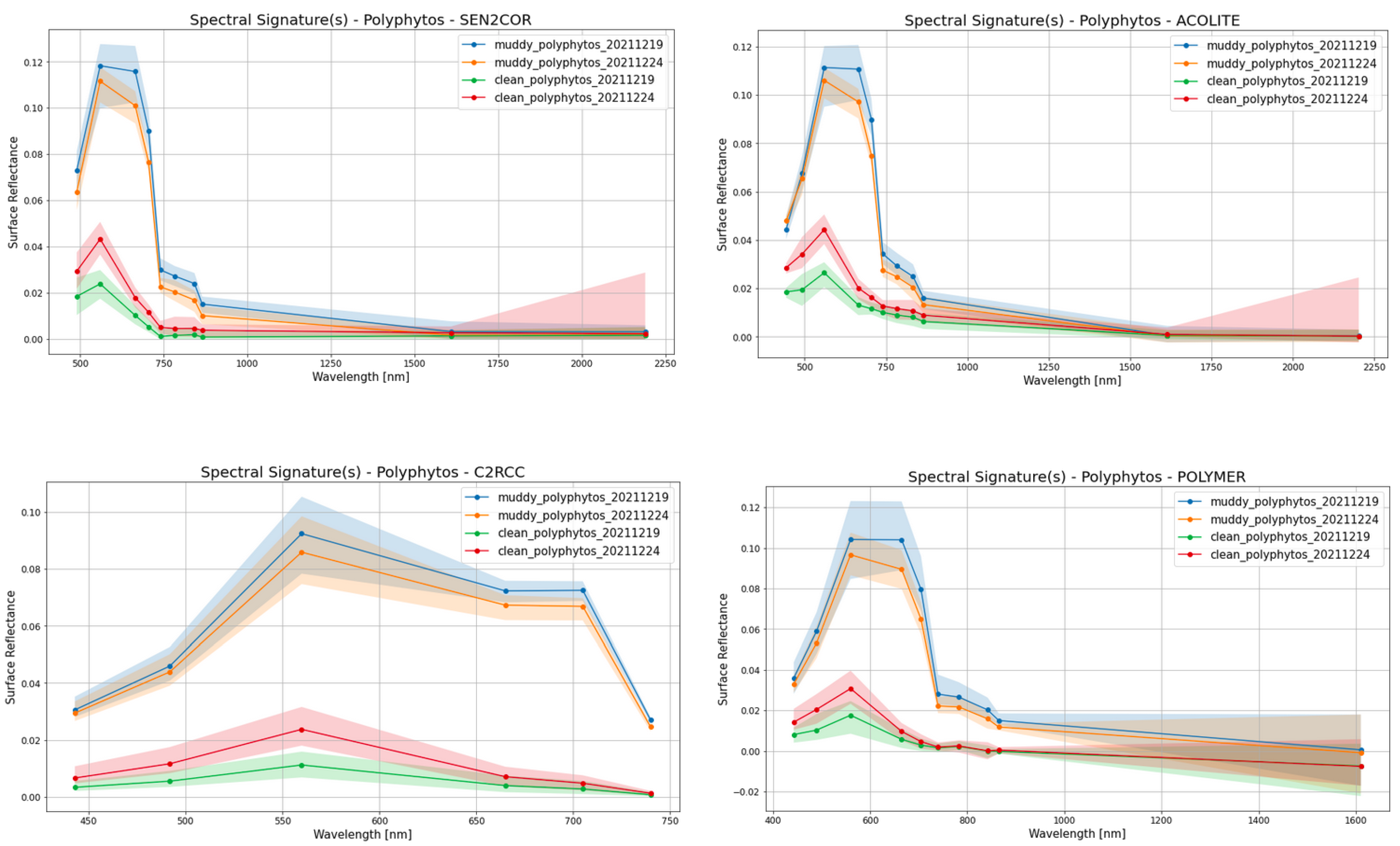
3.2. Atmospheric Corrections
3.3. Data Annotation
Alternative Annotation Approaches
3.4. Limitations
3.5. Random Forest vs. Convolutional Neural Networks
- Lack of Spatial/Spectral/Temporal Information: Random Forest generally treats each pixel as an independent data point not considering spatial autocorrelation among neighboring pixels and spectral autocorrelation among bands per pixel, while this is not the case for CNNs as the can implement convolution operations in both spatial, spectral or even temporal dimensions at once or separately.
- Feature Engineering: Random Forest relies on handcrafted features or raw pixel values, which may not capture complex hierarchical features in the data as effectively as CNNs, thus it heavily depends on feature engineering, where domain expertise is required. On the other hand, CNNs automatically learn hierarchical features from the image data reducing the need for extensive feature engineering, which would allow for an easier build of end-to-end learning architectures.
- Scalability: Random Forest can be computationally expensive when applied to large-scale image datasets, as it involves building and maintaining multiple decision trees. CNNs can be more scalable for image processing tasks because they utilize shared weights and feature maps, making them more efficient for large images.
3.6. Prospect and Usability
3.7. Suggestions for Monitoring Improvements
4. Conclusions
Author Contributions
Funding
Institutional Review Board Statement
Informed Consent Statement
Data Availability Statement
Conflicts of Interest
Abbreviations
| AOI | Area Of Interest |
| ML | Machine Learning |
| AC | Atmospheric Correction |
| SCL | Scene Classification Layer |
| NDTI | Normalized Difference Turbidity Index |
| MNDWI | Modified Normalized Difference Water Index |
| RF | Random Forest |
| TSS | Total Suspended Sediment |
References
- Davies-Colley, R.; Smith, D. Turbidity suspeni)ed sediment, and water clarity: A review. J. Am. Water Resour. Assoc. 2001, 37, 1085–1101. [Google Scholar] [CrossRef]
- Bilotta, G.S.; Brazier, R.E. Understanding the influence of suspended solids on water quality and aquatic biota. Water Res. 2008, 42, 2849–2861. [Google Scholar] [CrossRef] [PubMed]
- Albering, H.J.; Rila, J.P.; Moonen, E.; Hoogewerff, J.A.; Kleinjans, J. Human health risk assessment in relation to environmental pollution of two artificial freshwater lakes in The Netherlands. Environ. Health Perspect. 1999, 107, 27–35. [Google Scholar] [CrossRef] [PubMed]
- Mingzhou, Q.; Jackson, R.H.; Zhongjin, Y.; Jackson, M.W.; Bo, S. The effects of sediment-laden waters on irrigated lands along the lower Yellow River in China. J. Environ. Manag. 2007, 85, 858–865. [Google Scholar] [CrossRef] [PubMed]
- Mann, A.G.; Tam, C.C.; Higgins, C.D.; Rodrigues, L.C. The association between drinking water turbidity and gastrointestinal illness: A systematic review. BMC Public Health 2007, 7, 256. [Google Scholar] [CrossRef]
- Schwartz, J.; Levin, R.; Goldstein, R. Drinking water turbidity and gastrointestinal illness in the elderly of Philadelphia. J. Epidemiol. Community Health 2000, 54, 45–51. [Google Scholar] [CrossRef]
- Gauthier, V.; Barbeau, B.; Tremblay, G.; Millette, R.; Bernier, A.M. Impact of raw water turbidity fluctuations on drinking water quality in a distribution system. J. Environ. Eng. Sci. 2003, 2, 281–291. [Google Scholar] [CrossRef]
- Richter, B.D.; Braun, D.P.; Mendelson, M.A.; Master, L.L. Threats to imperiled freshwater fauna: Amenazas a la fauna dulceacuicola en riesgo. Conserv. Biol. 1997, 11, 1081–1093. [Google Scholar] [CrossRef]
- Henley, W.; Patterson, M.; Neves, R.; Lemly, A.D. Effects of sedimentation and turbidity on lotic food webs: A concise review for natural resource managers. Rev. Fish. Sci. 2000, 8, 125–139. [Google Scholar] [CrossRef]
- Hollis, E.H.; Boone, J.G.; DeRose, C.R.; Murphy, G.J. A Literature Review of the Effects of Turbidity and Siltation on Aquatic Life; Unpublished Staff Report; Department of Chesapeake Bay Affairs: Annapolis, MD, USA, 1964.
- Dunlop, J.; McGregor, G.; Horrigan, N. Potential Impacts of Salinity and Turbidity in Riverine Ecosystems. National Action Plan for Salinity and Water Quality; Technical Report, WQ06 Technical Report. QNRM05523; The National Action Plan for Salinity and Water Quality (NAPSWQ): Queensland, Australia, 2005.
- Yang, H.; Kong, J.; Hu, H.; Du, Y.; Gao, M.; Chen, F. A review of remote sensing for water quality retrieval: Progress and challenges. Remote Sens. 2022, 14, 1770. [Google Scholar] [CrossRef]
- Toming, K.; Kutser, T.; Uiboupin, R.; Arikas, A.; Vahter, K.; Paavel, B. Mapping water quality parameters with sentinel-3 ocean and land colour instrument imagery in the Baltic Sea. Remote Sens. 2017, 9, 1070. [Google Scholar] [CrossRef]
- Shen, M.; Duan, H.; Cao, Z.; Xue, K.; Qi, T.; Ma, J.; Liu, D.; Song, K.; Huang, C.; Song, X. Sentinel-3 OLCI observations of water clarity in large lakes in eastern China: Implications for SDG 6.3. 2 evaluation. Remote Sens. Environ. 2020, 247, 111950. [Google Scholar] [CrossRef]
- Surisetty, V.V.A.K.; Sahay, A.; Ramakrishnan, R.; Samal, R.N.; Rajawat, A.S. Improved turbidity estimates in complex inland waters using combined NIR–SWIR atmospheric correction approach for Landsat 8 OLI data. Int. J. Remote Sens. 2018, 39, 7463–7482. [Google Scholar] [CrossRef]
- Ma, Y.; Song, K.; Wen, Z.; Liu, G.; Shang, Y.; Lyu, L.; Du, J.; Yang, Q.; Li, S.; Tao, H.; et al. Remote sensing of turbidity for lakes in northeast China using Sentinel-2 images with machine learning algorithms. IEEE J. Sel. Top. Appl. Earth Obs. Remote Sens. 2021, 14, 9132–9146. [Google Scholar] [CrossRef]
- Sa’ad, F.N.A.; Tahir, M.S.; Jemily, N.H.B.; Ahmad, A.; Amin, A.R.M. Monitoring Total Suspended Sediment Concentration in Spatiotemporal Domain over Teluk Lipat Utilizing Landsat 8 (OLI). Appl. Sci. 2021, 11, 7082. [Google Scholar] [CrossRef]
- Bi, S.; Li, Y.; Xu, J.; Liu, G.; Song, K.; Mu, M.; Lyu, H.; Miao, S.; Xu, J. Optical classification of inland waters based on an improved Fuzzy C-Means method. Opt. Express 2019, 27, 34838–34856. [Google Scholar] [CrossRef] [PubMed]
- Xu, H.; Xu, G.; Wen, X.; Hu, X.; Wang, Y. Lockdown effects on total suspended solids concentrations in the Lower Min River (China) during COVID-19 using time-series remote sensing images. Int. J. Appl. Earth Obs. Geoinf. 2021, 98, 102301. [Google Scholar] [CrossRef]
- Tripathi, G.; Pandey, A.C.; Parida, B.R. Spatio-temporal analysis of turbidity in ganga river in patna, bihar using sentinel-2 satellite data linked with covid-19 pandemic. In Proceedings of the 2020 IEEE India Geoscience and Remote Sensing Symposium (InGARSS), Virtual, 2–4 December 2020; pp. 29–32. [Google Scholar]
- Garg, V.; Aggarwal, S.P.; Chauhan, P. Changes in turbidity along Ganga River using Sentinel-2 satellite data during lockdown associated with COVID-19. Geomat. Nat. Hazards Risk 2020, 11, 1175–1195. [Google Scholar] [CrossRef]
- Wang, J.; Tong, Y.; Feng, L.; Zhao, D.; Zheng, C.; Tang, J. Satellite-Observed Decreases in Water Turbidity in the Pearl River Estuary: Potential Linkage With Sea-Level Rise. J. Geophys. Res. Ocean. 2021, 126, e2020JC016842. [Google Scholar] [CrossRef]
- Jensen, J.R. Digital Image Processing: A Remote Sensing Perspectives; Prentice Hall: Upper Saddle River, NJ, USA, 2005. [Google Scholar]
- Sumbul, G.; Charfuelan, M.; Demir, B.; Markl, V. Bigearthnet: A large-scale benchmark archive for remote sensing image understanding. In Proceedings of the IGARSS 2019–2019 IEEE International Geoscience and Remote Sensing Symposium, Yokohama, Japan, 28 July–2 August 2019; pp. 5901–5904. [Google Scholar]
- Tseng, G.; Zvonkov, I.; Nakalembe, C.L.; Kerner, H. Cropharvest: A global dataset for crop-type classification. In Proceedings of the Thirty-Fifth Conference on Neural Information Processing Systems Datasets and Benchmarks Track (Round 2), Virtual, 11 October 2021. [Google Scholar]
- Helber, P.; Bischke, B.; Dengel, A.; Borth, D. Eurosat: A novel dataset and deep learning benchmark for land use and land cover classification. IEEE J. Sel. Top. Appl. Earth Obs. Remote Sens. 2019, 12, 2217–2226. [Google Scholar] [CrossRef]
- Rumora, L.; Miler, M.; Medak, D. Impact of various atmospheric corrections on sentinel-2 land cover classification accuracy using machine learning classifiers. ISPRS Int. J. Geo-Inf. 2020, 9, 277. [Google Scholar] [CrossRef]
- Song, C.; Woodcock, C.E.; Seto, K.C.; Lenney, M.P.; Macomber, S.A. Classification and change detection using Landsat TM data: When and how to correct atmospheric effects? Remote Sens. Environ. 2001, 75, 230–244. [Google Scholar] [CrossRef]
- Emberton, S.; Chittka, L.; Cavallaro, A.; Wang, M. Sensor capability and atmospheric correction in ocean colour remote sensing. Remote Sens. 2015, 8, 1. [Google Scholar] [CrossRef]
- Gordon, H.R. Evolution of ocean color atmospheric correction: 1970–2005. Remote Sens. 2021, 13, 5051. [Google Scholar] [CrossRef]
- Maurya, L.; Lohchab, V.; Mahapatra, P.K.; Abonyi, J. Contrast and brightness balance in image enhancement using Cuckoo Search-optimized image fusion. J. King Saud Univ.-Comput. Inf. Sci. 2022, 34, 7247–7258. [Google Scholar] [CrossRef]
- Akbarinia, A.; Gil-Rodriguez, R. Deciphering image contrast in object classification deep networks. Vis. Res. 2020, 173, 61–76. [Google Scholar] [CrossRef]
- Guo, J.; Ma, J.; García-Fernández, Á.F.; Zhang, Y.; Liang, H. A survey on image enhancement for Low-light images. Heliyon 2023, 9, e14558. [Google Scholar] [CrossRef] [PubMed]
- Cai, T.; Zhu, F.; Hao, Y.; Fan, X. Performance evaluation of image enhancement methods for objects detection and recognition. In Proceedings of the AOPC 2015: Image Processing and Analysis, SPIE, Beijing, China, 8 October 2015; Volume 9675, pp. 732–736. [Google Scholar]
- Xu, H. Modification of normalised difference water index (NDWI) to enhance open water features in remotely sensed imagery. Int. J. Remote Sens. 2006, 27, 3025–3033. [Google Scholar] [CrossRef]
- Lacaux, J.; Tourre, Y.; Vignolles, C.; Ndione, J.; Lafaye, M. Classification of ponds from high-spatial resolution remote sensing: Application to Rift Valley Fever epidemics in Senegal. Remote Sens. Environ. 2007, 106, 66–74. [Google Scholar] [CrossRef]
- McFeeters, S.K. The use of the Normalized Difference Water Index (NDWI) in the delineation of open water features. Int. J. Remote Sens. 1996, 17, 1425–1432. [Google Scholar] [CrossRef]
- Belgiu, M.; Drăguţ, L. Random forest in remote sensing: A review of applications and future directions. ISPRS J. Photogramm. Remote Sens. 2016, 114, 24–31. [Google Scholar] [CrossRef]
- Pal, M. Random forest classifier for remote sensing classification. Int. J. Remote Sens. 2005, 26, 217–222. [Google Scholar] [CrossRef]
- Sdraka, M.; Papoutsis, I.; Psomas, B.; Vlachos, K.; Ioannidis, K.; Karantzalos, K.; Gialampoukidis, I.; Vrochidis, S. Deep learning for downscaling remote sensing images: Fusion and super-resolution. IEEE Geosci. Remote Sens. Mag. 2022, 10, 202–255. [Google Scholar] [CrossRef]


| AOI | Date | Bbox Centre/CRS |
|---|---|---|
| Polyphytos (lacustrine) | 19 December 2021 | (581,825.0, 4,450,935.0)/WGS 84-UTM34 |
| Giaretta 1 (riverine) | 31 October 2018 | (711,130.0, 5,059,485.0)/WGS 84-UTM32 |
| Giaretta 2 (coastal, riverine) | 31 October 2018 | (765,180.0, 5,008,570.0)/WGS 84-UTM32 |
| Giaretta 3 (coastal, riverine) | 31 October 2018 | (783,740.0, 5,052,260.0)/WGS 84-UTM32 |
| Pori (coastal, riverine) | 20 April 2021 | (528,945.0, 6,835,175.0)/WGS 84-UTM34 |
| Salo (coastal, riverine) | 20 April 2021 | (592,060.0, 6,686,600.0)/WGS 84-UTM34 |
| Band | Central Wavelength | Resolution 2 | Description |
|---|---|---|---|
| nm | m | Ultra Blue (Coastal and Aerosol) | |
| nm | m | Blue | |
| nm | m | Green | |
| nm | m | Red | |
| nm | m | Visible and Near Infrared (VNIR) | |
| nm | m | Visible and Near Infrared (VNIR) | |
| nm | m | Visible and Near Infrared (VNIR) | |
| nm | m | Visible and Near Infrared (VNIR) | |
| nm | m | Visible and Near Infrared (VNIR) | |
| nm | m | Short Wave Infrared (SWIR) | |
| nm | m | Short Wave Infrared (SWIR) | |
| nm | m | Short Wave Infrared (SWIR) | |
| nm | m | Short Wave Infrared (SWIR) |
| Number of Trees | Tree Depth | Class Balance |
|---|---|---|
| 4, 5, 6, 8,10, 20, 30, 60, 100, 120, 150 | 5, 6, 7, 10, 20, 50, 100, 150, 200 | sample balance, no balance |
Disclaimer/Publisher’s Note: The statements, opinions and data contained in all publications are solely those of the individual author(s) and contributor(s) and not of MDPI and/or the editor(s). MDPI and/or the editor(s) disclaim responsibility for any injury to people or property resulting from any ideas, methods, instructions or products referred to in the content. |
© 2023 by the authors. Licensee MDPI, Basel, Switzerland. This article is an open access article distributed under the terms and conditions of the Creative Commons Attribution (CC BY) license (https://creativecommons.org/licenses/by/4.0/).
Share and Cite
Psychalas, C.; Vlachos, K.; Moumtzidou, A.; Gialampoukidis, I.; Vrochidis, S.; Kompatsiaris, I. Towards a Paradigm Shift on Mapping Muddy Waters with Sentinel-2 Using Machine Learning. Sustainability 2023, 15, 13441. https://doi.org/10.3390/su151813441
Psychalas C, Vlachos K, Moumtzidou A, Gialampoukidis I, Vrochidis S, Kompatsiaris I. Towards a Paradigm Shift on Mapping Muddy Waters with Sentinel-2 Using Machine Learning. Sustainability. 2023; 15(18):13441. https://doi.org/10.3390/su151813441
Chicago/Turabian StylePsychalas, Christos, Konstantinos Vlachos, Anastasia Moumtzidou, Ilias Gialampoukidis, Stefanos Vrochidis, and Ioannis Kompatsiaris. 2023. "Towards a Paradigm Shift on Mapping Muddy Waters with Sentinel-2 Using Machine Learning" Sustainability 15, no. 18: 13441. https://doi.org/10.3390/su151813441
APA StylePsychalas, C., Vlachos, K., Moumtzidou, A., Gialampoukidis, I., Vrochidis, S., & Kompatsiaris, I. (2023). Towards a Paradigm Shift on Mapping Muddy Waters with Sentinel-2 Using Machine Learning. Sustainability, 15(18), 13441. https://doi.org/10.3390/su151813441