
Estimation of the Coastal Vulnerability Index Using Multi-Criteria Decision Making: The Coastal Social–Ecological System of Rachgoun, Western Algeria


 , ,
, ,  and
and 
Abstract
1. Introduction
2. Materials and Methods
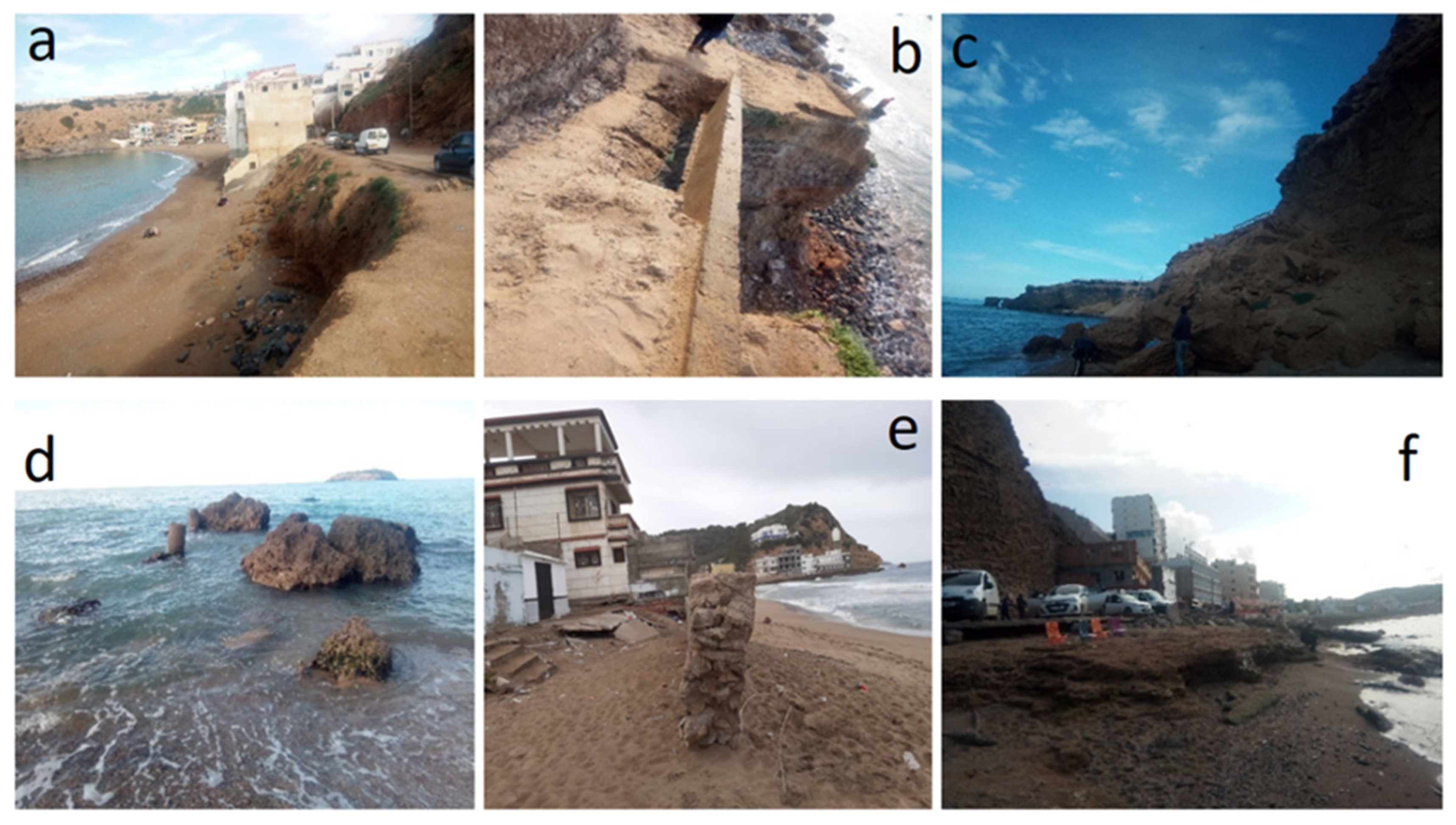
2.1. Study Area
- The prehistoric site of Rachgoun (7000 BC);
- Siga, Numidian kingdom of Syfax, also known as Siga-Takembrit by the local population (206 BC);
- The Mausoleum of Syphax (3rd century BC).

2.2. Methodology
2.2.1. Parameter Selection and Ranking
Natural Criteria
- i
- Geomorphological Parameters
- 1.
- Lithology
- 2.
- Elevation and slope
- 3.
- Proximity to coast and distance from river
- ii
- Physical Parameters
- 1.
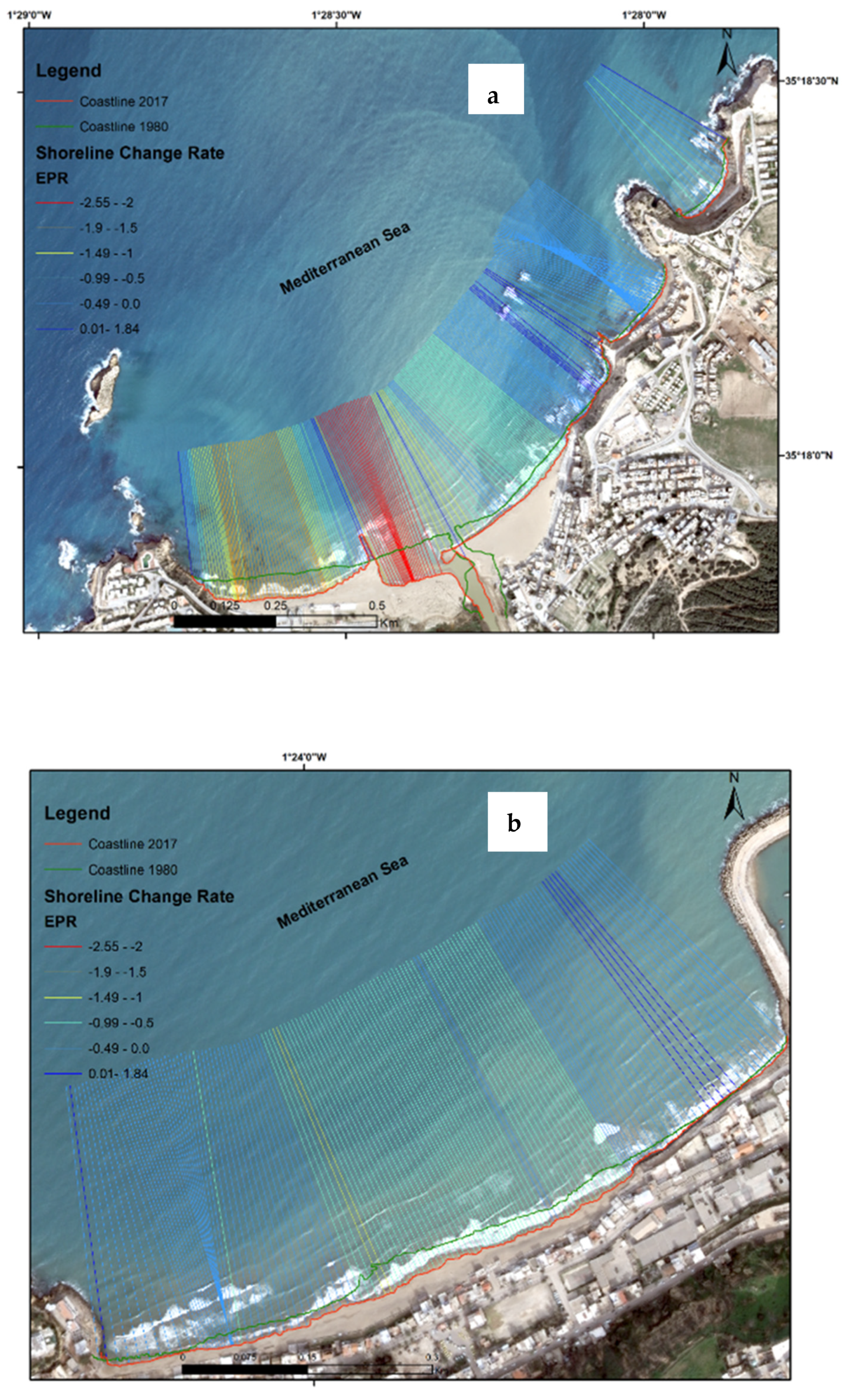
- Shoreline change
- 2.
- Significant wave height (Hs)
Socioeconomic Variables
- 1.
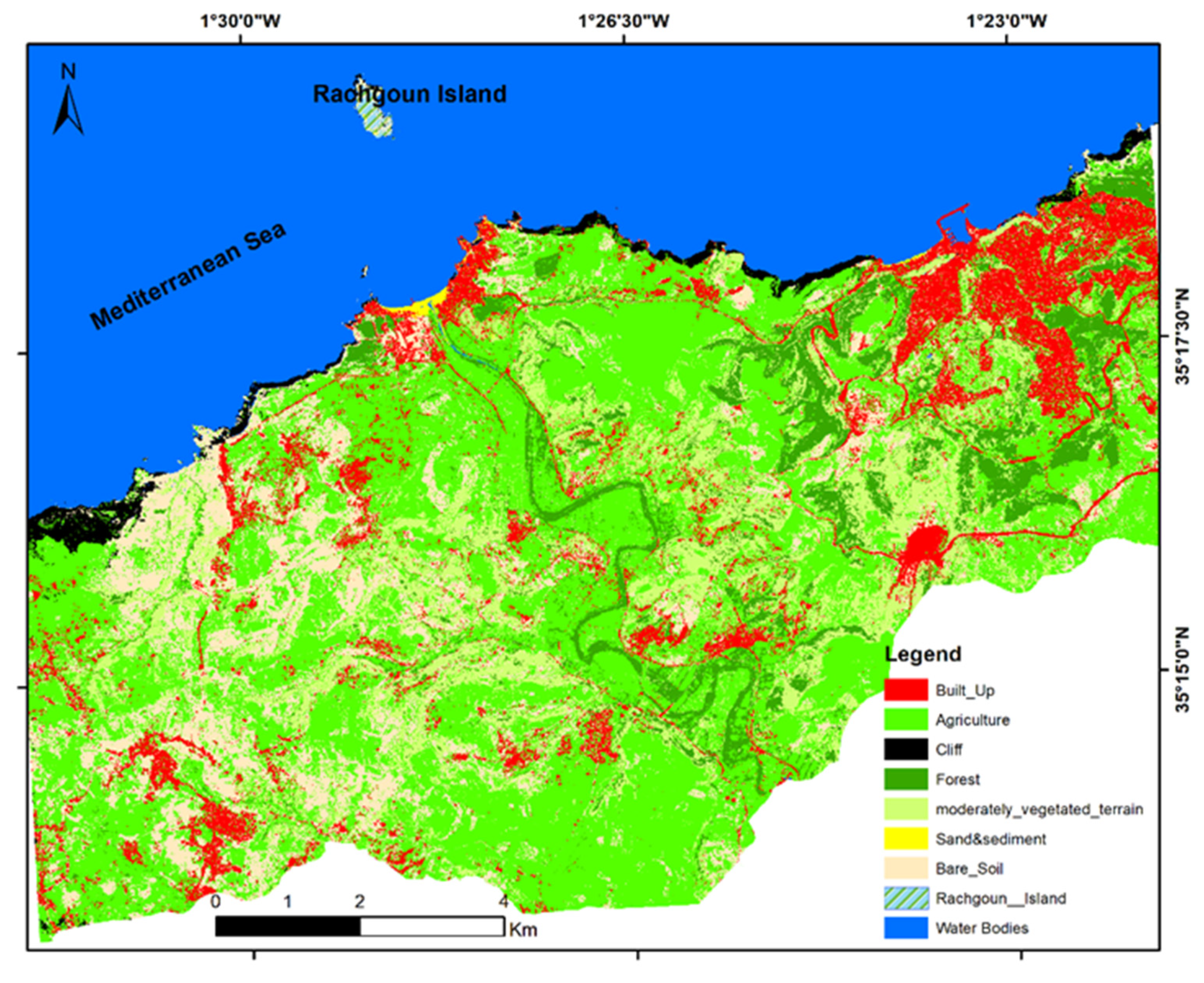
- Land use/land cover (LULC)
- 2.
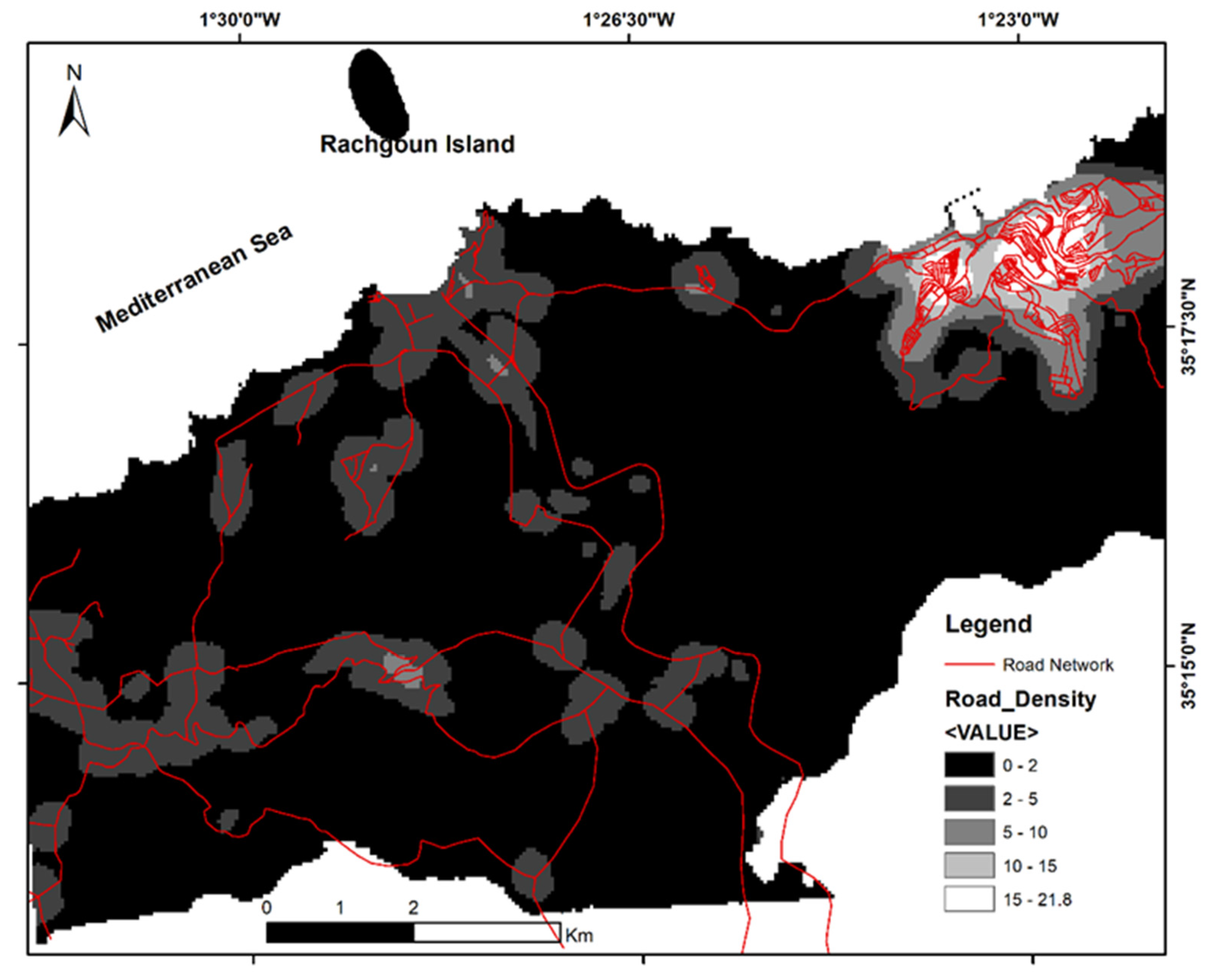
- Road network density
- 3.
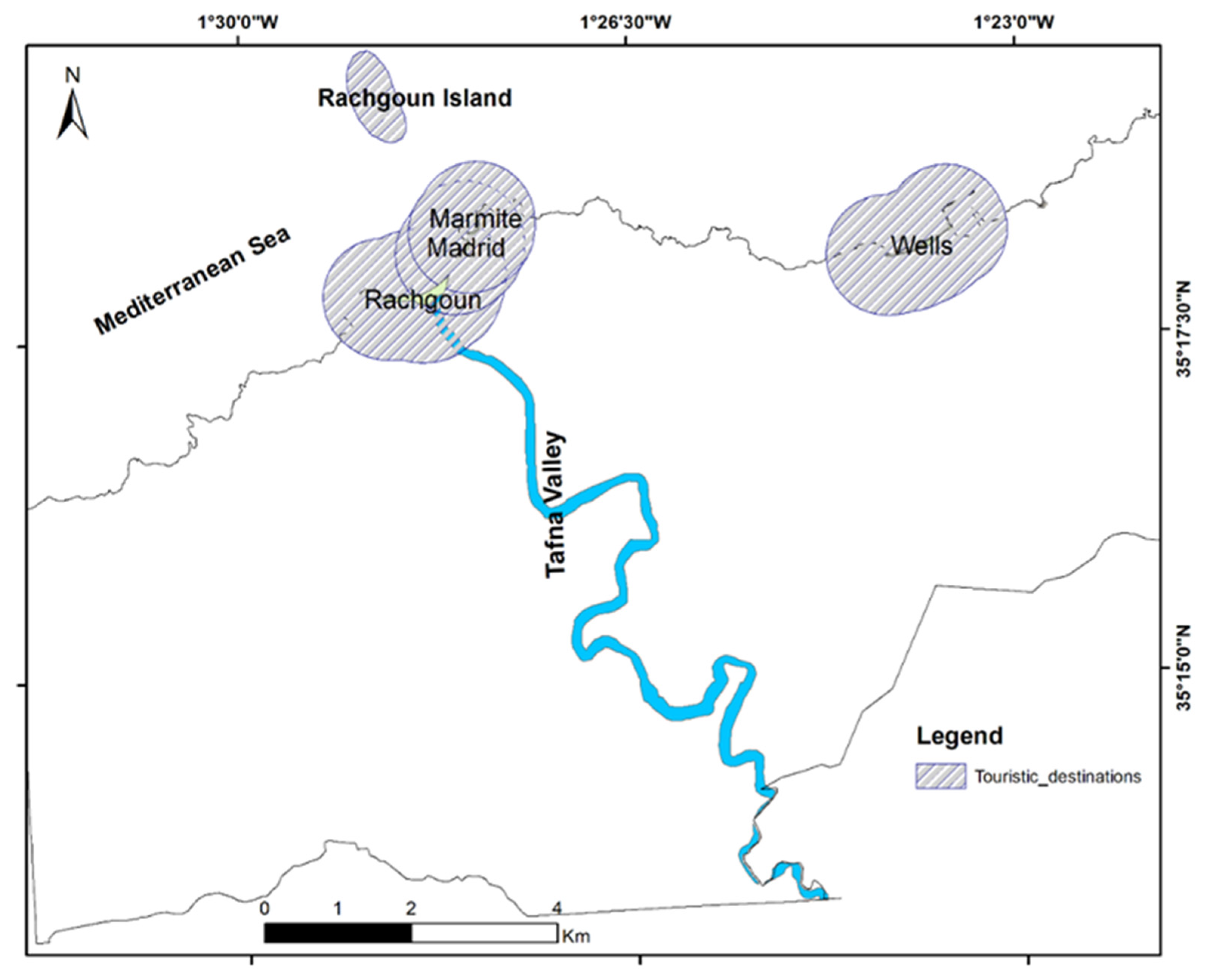
- Designated conservation areas and cultural heritage
- 4.
- Population density and touristic density
- 5.
- People’s Awareness
2.2.2. MCDM Method and CVI Estimation
CVI Estimation
2.2.3. Fieldwork
3. Results and Discussion
3.1. Coastal Vulnerability Index Mapping
3.1.1. Natural Coastal Vulnerability Index
3.1.2. Socioeconomic Coastal Vulnerability Index
3.1.3. Global Integrated Coastal Vulnerability Index
3.2. Vulnerability Relative Impact
4. Conclusions
Author Contributions
Funding
Data Availability Statement
Acknowledgments
Conflicts of Interest
References
- Gutierres, F.; Teodoro, A.C.; Reis, E.; Neto, C.; Costa, J.C. Remote sensing technologies for the assessment of marine and coastal ecosystems. In Seafloor Mapping along Continental Shelves: Research and Techniques for Visualizing Benthic Environments; Springer: Cham, Switzerland, 2016; pp. 69–104. [Google Scholar]
- Turner, R.K.; Subak, S.; Adger, W.N. Pressures, trends, and impacts in coastal zones: Interactions between socioeconomic and natural systems. Environ. Manag. 1996, 20, 159–173. [Google Scholar] [CrossRef]
- Martínez, M.L.; Maun, M.; Psuty, N. The fragility and conservation of the world’s coastal dunes: Geomorphological, ecological and socioeconomic perspectives. In Coastal Dunes: Ecology and Conservation; Springer: Berlin/Heidelberg, Germany, 2004; pp. 355–369. [Google Scholar]
- Boumaour, A.; Grimes, S.; Brigand, L.; Larid, M. Integration process and stakeholders’ interactions analysis around a protection project: Case of the National park of Gouraya, Algeria (South-western Mediterranean). Ocean Coast. Manag. 2018, 153, 215–230. [Google Scholar] [CrossRef]
- Bukvic, A.; Rohat, G.; Apotsos, A.; de Sherbinin, A. A systematic review of coastal vulnerability mapping. Sustainability 2020, 12, 2822. [Google Scholar] [CrossRef]
- Giry, F.; Binet, T.; Keurmeur, N. Les bénéfices de la protection des mangroves de l’outre-mer français par le Conservatoire du littoral: Une évaluation économique à l’horizon 2040. Etudes Caribéennes 2017. [Google Scholar] [CrossRef]
- Schlüter, A.; Partelow, S.; Torres-Guevara, L.E.; Jennerjahn, T.C. Coastal commons as social-ecological systems. In Routledge Handbook of the Study of the Commons; Routledge: Milton Park, UK, 2019; pp. 170–187. [Google Scholar]
- Rocha, C.; Antunes, C.; Catita, C. Coastal vulnerability assessment due to sea level rise: The case study of the Atlantic coast of mainland Portugal. Water 2020, 12, 360. [Google Scholar] [CrossRef]
- Gain, A.K.; Giupponi, C.; Renaud, F.G.; Vafeidis, A.T. Sustainability of Complex Social-Ecological Systems: Methods, Tools, and Approaches; Springer: Berlin/Heidelberg, Germany, 2020; Volume 20, pp. 1–4. [Google Scholar]
- Folke, C.; Hahn, T.; Olsson, P.; Norberg, J. Adaptive governance of social-ecological systems. Annu. Rev. Environ. Resour. 2005, 30, 441–473. [Google Scholar] [CrossRef]
- Hinkel, J.; Bots, P.W.; Schlüter, M. Enhancing the Ostrom social-ecological system framework through formalization. Ecol. Soc. 2014, 19, 51. [Google Scholar] [CrossRef]
- Gain, A.K.; Ashik-Ur-Rahman, M.; Vafeidis, A. Exploring human-nature interaction on the coastal floodplain in the Ganges-Brahmaputra delta through the lens of Ostrom’s social-ecological systems framework. Environ. Res. Commun. 2019, 1, 051003. [Google Scholar] [CrossRef]
- Del Mar Delgado-Serrano, M.; Ramos, P. Making Ostrom’s framework applicable to characterise social ecological systems at the local level. Int. J. Commons 2015, 9, 808–830. [Google Scholar] [CrossRef]
- Hossain, M.S.; Eigenbrod, F.; Amoako Johnson, F.; Dearing, J.A. Unravelling the interrelationships between ecosystem services and human wellbeing in the Bangladesh delta. Int. J. Sustain. Dev. World Ecol. 2017, 24, 120–134. [Google Scholar] [CrossRef]
- Gari, S.R.; Newton, A.; Icely, J.D. A review of the application and evolution of the DPSIR framework with an emphasis on coastal social-ecological systems. Ocean Coast. Manag. 2015, 103, 63–77. [Google Scholar] [CrossRef]
- De Andrés, M.; Barragán, J.M.; Scherer, M. Urban centres and coastal zone definition: Which area should we manage? Land Use Policy 2018, 71, 121–128. [Google Scholar] [CrossRef]
- Hossain, M.S.; Gain, A.K.; Rogers, K.G. Sustainable Coastal Social-Ecological Systems: How Do We Define “Coastal”? Taylor & Francis: Boca Raton, FL, USA, 2020; Volume 27, pp. 577–582. [Google Scholar]
- Lins-de-Barros, F.M. Integrated coastal vulnerability assessment: A methodology for coastal cities management integrating socioeconomic, physical and environmental dimensions-Case study of Região dos Lagos, Rio de Janeiro, Brazil. Ocean Coast. Manag. 2017, 149, 1–11. [Google Scholar] [CrossRef]
- Turner, B.L.; Kasperson, R.E.; Matson, P.A.; McCarthy, J.J.; Corell, R.W.; Christensen, L.; Eckley, N.; Kasperson, J.X.; Luers, A.; Martello, M.L. A framework for vulnerability analysis in sustainability science. Proc. Natl. Acad. Sci. USA 2003, 100, 8074–8079. [Google Scholar] [CrossRef] [PubMed]
- Adger, W.N.; Hughes, T.P.; Folke, C.; Carpenter, S.R.; Rockstrom, J. Social-ecological resilience to coastal disasters. Science 2005, 309, 1036–1039. [Google Scholar] [CrossRef]
- VanZomeren, C.M.; Acevedo-Mackey, D. A Review of Coastal Vulnerability Assessments: Definitions, Components, and Variables; No. ERDC/EL SR-19-5; U.S. Environmental Laboratory, Engineer Research and Development Center: Richmond, CA, USA, 2019. [Google Scholar] [CrossRef]
- Gornitz, V.; White, T.W.; Cushman, R.M. Vulnerability of the US to Future Sea Level Rise; Oak Ridge National Lab.: Oak Ridge, TN, USA, 1991. [Google Scholar]
- Szlafsztein, C.; Sterr, H. A GIS-based vulnerability assessment of coastal natural hazards, state of Pará, Brazil. J. Coast. Conserv. 2007, 11, 53–66. [Google Scholar] [CrossRef]
- Mclaughlin, S.; Cooper, J.A.G. A multi-scale coastal vulnerability index: A tool for coastal managers? Environ. Hazards 2010, 9, 233–248. [Google Scholar] [CrossRef]
- Sahoo, B.; Bhaskaran, P.K. Multi-hazard risk assessment of coastal vulnerability from tropical cyclones–A GIS based approach for the Odisha coast. J. Environ. Manag. 2018, 206, 1166–1178. [Google Scholar] [CrossRef]
- Ariffin, E.H.; Mathew, M.J.; Roslee, A.; Ismailluddin, A.; Yun, L.S.; Putra, A.B.; Yusof, K.M.K.K.; Menhat, M.; Ismail, I.; Shamsul, H.A. A multi-hazards coastal vulnerability index of the east coast of Peninsular Malaysia. Int. J. Disaster Risk Reduct. 2023, 84, 103484. [Google Scholar] [CrossRef]
- Ammi, H. Villes et Développement Économique en Algérie; Université de Toulon: La Garde, France, 2019. [Google Scholar]
- Amarouche, K.; Akpınar, A.; Bachari, N.E.I.; Houma, F. Wave energy resource assessment along the Algerian coast based on 39-year wave hindcast. Renew. Energy 2020, 153, 840–860. [Google Scholar] [CrossRef]
- Otmani, H.; Belkessa, R.; Rabehi, W.; Guerfi, M.; Boukhdiche, W. Dégradation des dunes côtières algéroises entre pression de l’urbanisation et conséquences sur l’évolution de la ligne de rivage. GeoEcoMarina 2019, 25, 131–145. [Google Scholar]
- Salem Cherif, Y.; Mezouar, K.; Guerfi, M.; Sallaye, M.; Dahmani, A.E.A. Nearshore hydrodynamics and sediment transport processes along the sandy coast of Boumerdes, Algeria. Arab. J. Geosci. 2019, 12, 800. [Google Scholar] [CrossRef]
- Sallaye, M.; Mezouar, K.; Salem Cherif, Y.; Dahmani, A.E.A. Morphological evolution of center Boumerdes in Zemmouri Bay (Algeria) from 1922 to 2017. Arab. J. Geosci. 2018, 11, 602. [Google Scholar] [CrossRef]
- Senouci, R.; Taibi, N.-E.; Teodoro, A.C.; Duarte, L.; Mansour, H.; Yahia Meddah, R. GIS-based expert knowledge for landslide susceptibility mapping (LSM): Case of mostaganem coast district, west of Algeria. Sustainability 2021, 13, 630. [Google Scholar] [CrossRef]
- Djabri, L.; Ghrieb, L.; Guezgouz, N.; Hani, A.; Bouhsina, S. Impacts of morphological factors on the marine intrusion in Annaba region (east of Algeria). Desalination Water Treat. 2014, 52, 2151–2156. [Google Scholar] [CrossRef]
- Djoudar Hallal, D.; Khelfi, M.E.A.; Zahouani, S.; Benamghar, A.; Haddad, O.; Ammari, A.; Lobo-Ferreira, J.P. Application of the GALDIT method combined with geostatistics at the Bouteldja aquifer (Algeria). Environ. Earth Sci. 2019, 78, 22. [Google Scholar] [CrossRef]
- Silhadi, M.A.; Refes, W.; Mazouzi, S. Assessment of coastal ecosystems vulnerability to pollution: Algiers coast, Algeria. Environ. Sci. Pollut. Res. 2020, 27, 42670–42684. [Google Scholar] [CrossRef]
- Zaimen, F.; Ghodbani, T.; Vermeren, H. L’activité de pêche artisanale au sud de la Méditerranée: Gouvernance, dynamique socio-économique et enjeux environnementaux dans le port algérien de Jijel (Boudis). VertigO-La Rev. Électronique En Sci. De l’Environnement 2021, 21. [Google Scholar] [CrossRef]
- Mihoubi, M.; Belkessa, R.; Latreche, M. Study of the vulnerability of coastal areas of the Algerian Basin with the GIS. Int. J. Environ. Sci. Dev. 2014, 5, 522. [Google Scholar] [CrossRef]
- Djouder, F.; Boutiba, M. Vulnerability assessment of coastal areas to sea level rise from the physical and socioeconomic parameters: Case of the Gulf Coast of Bejaia, Algeria. Arab. J. Geosci. 2017, 10, 299. [Google Scholar] [CrossRef]
- Rabehi, W.; Guerfi, M.; Mahi, H. Cartographie de la vulnérabilité des communes de la baie d’Alger. Approche socio-économique et physique de la côte. Méditerranée. Rev. Géographique Des Pays Méditerranéens/J. Mediterr. Geogr. 2018. [Google Scholar] [CrossRef]
- Chaib, W.; Guerfi, M.; Hemdane, Y. Evaluation of coastal vulnerability and exposure to erosion and submersion risks in Bou Ismail Bay (Algeria) using the coastal risk index (CRI). Arab. J. Geosci. 2020, 13, 420. [Google Scholar] [CrossRef]
- Ministère chargé de l’environnement; Priority Actions Programme Regional Activity Centre (PAPA/RAC)/Plan d’action pour la Méditerranée (PAM). Stratégie-Nationale-de-Gestion-Intégrée-des-Zones-Côtières, Appui PAM Med Partnership; UNESCO: Paris, France, 2015; p. 94. [Google Scholar]
- Mohamed, S.A. Coastal vulnerability assessment using GIS-Based multicriteria analysis of Alexandria-northwestern Nile Delta, Egypt. J. Afr. Earth Sci. 2020, 163, 103751. [Google Scholar] [CrossRef]
- Robertson, C.; Feick, R. Defining local experts: Geographical expertise as a basis for geographic information quality. In Proceedings of the 13th International Conference on Spatial Information Theory (COSIT 2017), L’Aquila, Italy, 4–8 September 2017; Schloss Dagstuhl-Leibniz-Zentrum fuer Informatik: Wadern, Germany, 2017. [Google Scholar]
- Chandra, A.; Gaganis, P. Deconstructing vulnerability and adaptation in a coastal river basin ecosystem: A participatory analysis of flood risk in Nadi, Fiji Islands. Clim. Dev. 2016, 8, 256–269. [Google Scholar] [CrossRef]
- Camps, G. The Deposit of Rachgoun (Oranie); Anthropology Prehistory Ethnography: Libyca, Algiers, Algeria, 1966; pp. 160–183. [Google Scholar]
- Vuillemot, G. Siga et son port fluvial. Antiq. Afr. 1971, 5, 39–86. [Google Scholar] [CrossRef]
- Laporte, J.-P. Ptolémée et la Maurétanie césarienne. Comptes Rendus Séances L’académie Inscr. Belles-Lett. 2003, 147, 171–195. [Google Scholar] [CrossRef]
- Laporte, J.-P. Siga et l’île de Rachgoun; Carocci Editore: Roma, Italy, 2006. [Google Scholar]
- Carayon, N. Les Ports Phéniciens et Puniques. Géomorphologie et Infrastructures; Université Marc Bloch-Strasbourg II: Strasbourg, France, 2008. [Google Scholar]
- Betrouni, M. Rachgoun 2: Geomorphological and Lithostratigraphic Framework. Hist. Res. 2021, 9, 104–117. [Google Scholar] [CrossRef]
- Aimé, S.; Remaoun, K. Variabilité climatique et steppisation dans le bassin de la Tafna (Oranie occidentale). Méditerranée 1988, 63, 43–51. [Google Scholar] [CrossRef]
- Gagneur, J. Twenty years of research on the Tafna ecosystem, an Algerian temporary stream. Int. Ver. Für Theor. Und Angew. Limnol. Verh. 2006, 29, 1998–2002. [Google Scholar] [CrossRef]
- Ketrouci, K.; Meddi, M.; Abdesselam, B. Study of the extreme floods in Algeria: The case of the Tafna catchment area. Sci. Et Chang. Planétaires/Sécheresse 2012, 23, 297–305. [Google Scholar] [CrossRef]
- Bakreti, A.; Braud, I.; Leblois, E.; Benali, A. Analyse conjointe des régimes pluviométriques et hydrologiques dans le bassin de la Tafna (Algérie Occidentale). Hydrol. Sci. J. 2013, 58, 133–151. [Google Scholar] [CrossRef]
- Centre d’Activités Régionales pour les Aires Spécialement Protégées- Programme des Nations Unies pour l’Environnement Plan d’Action pour la Méditerranée (CAR/ASP-PNUE/PAM). Île de Rachgoun. Cartographie des Habitats Marins Clés de Méditerranée et Initiation de Réseaux de Surveillance; Projet MedKeyHabitats; Ministère des Ressources en Eau et de l’Environnement (MREE) Government of Algeria: Kouba, Algeria, 2016; p. 113. [Google Scholar]
- Hamlat, A.; Guidoum, A.; Koulala, I. Status and trends of water quality in the Tafna catchment: A comparative study using water quality indices. J. Water Reuse Desalination 2017, 7, 228–245. [Google Scholar] [CrossRef]
- Houari, K.; Hartani, T.; Remini, B.; Lefkir, A.; Abda, L.; Heddam, S. A hybrid model for modelling the salinity of the Tafna River in Algeria. J. Water Land Dev. 2019, 40, 127–135. [Google Scholar] [CrossRef]
- Yebdri, L.; Hadji, F.; Harek, Y.; Marok, A. Quality assessment of water used for human consumption and irrigation purpose in parts of Tafna watershed (NW Algeria). Environ. Earth Sci. 2021, 80, 502. [Google Scholar] [CrossRef]
- Bouklikha, A.; Habi, M.; Elouissi, A.; Hamoudi, S. Annual, seasonal and monthly rainfall trend analysis in the Tafna watershed, Algeria. Appl. Water Sci. 2021, 11, 77. [Google Scholar] [CrossRef]
- Belarbi, H.; Touaibia, B.; Boumechra, N.; Abdelbaki, C.; Amiar, S. Analysis of the hydrological behavior of watersheds in the context of climate change (Northwestern Algeria). In Wadi Flash Floods; Springer: Berlin/Heidelberg, Germany, 2022; p. 143. [Google Scholar]
- Ostrom, E. A general framework for analyzing sustainability of social-ecological systems. Science 2009, 325, 419–422. [Google Scholar] [CrossRef]
- Schlüter, M.; Hinkel, J.; Bots, P.W.; Arlinghaus, R. Application of the SES framework for model-based analysis of the dynamics of social-ecological systems. Ecol. Soc. 2014, 19, 36. [Google Scholar] [CrossRef]
- Gornitz, V.M.; Daniels, R.C.; White, T.W.; Birdwell, K.R. The development of a coastal risk assessment database: Vulnerability to sea-level rise in the US Southeast. J. Coast. Res. 1994, 12, 327–338. [Google Scholar]
- Sudha Rani, N.; Satyanarayana, A.; Bhaskaran, P.K. Coastal vulnerability assessment studies over India: A review. Nat. Hazards 2015, 77, 405–428. [Google Scholar] [CrossRef]
- Vittal Hegde, A.; Radhakrishnan Reju, V. Development of coastal vulnerability index for Mangalore coast, India. J. Coast. Res. 2007, 23, 1106–1111. [Google Scholar] [CrossRef]
- Mahapatra, M.; Ramakrishnan, R.; Rajawat, A. Coastal vulnerability assessment of Gujarat coast to sea level rise using GIS techniques: A preliminary study. J. Coast. Conserv. 2015, 19, 241–256. [Google Scholar] [CrossRef]
- Mahmood, R.; Ahmed, N.; Zhang, L.; Li, G. Coastal vulnerability assessment of Meghna estuary of Bangladesh using integrated geospatial techniques. Int. J. Disaster Risk Reduct. 2020, 42, 101374. [Google Scholar] [CrossRef]
- Kunte, P.D.; Jauhari, N.; Mehrotra, U.; Kotha, M.; Hursthouse, A.S.; Gagnon, A.S. Multi-hazards coastal vulnerability assessment of Goa, India, using geospatial techniques. Ocean Coast. Manag. 2014, 95, 264–281. [Google Scholar] [CrossRef]
- Arun Kumar, A.; Kunte, P.D. Coastal vulnerability assessment for Chennai, east coast of India using geospatial techniques. Nat. Hazards 2012, 64, 853–872. [Google Scholar] [CrossRef]
- López Royo, M.; Ranasinghe, R.; Jiménez, J.A. A rapid, low-cost approach to coastal vulnerability assessment at a national level. J. Coast. Res. 2016, 32, 932–945. [Google Scholar] [CrossRef]
- Jana, S. Micro-level coastal vulnerability assessment in relation to post-Aila landscape alteration at the fragile coastal stretch of the Sagar Island, India. Reg. Stud. Mar. Sci. 2020, 33, 100908. [Google Scholar] [CrossRef]
- Koroglu, A.; Ranasinghe, R.; Jiménez, J.A.; Dastgheib, A. Comparison of coastal vulnerability index applications for Barcelona Province. Ocean Coast. Manag. 2019, 178, 104799. [Google Scholar] [CrossRef]
- Basheer Ahammed, K.; Mahendra, R.; Pandey, A. Coastal vulnerability assessment for Eastern Coast of India, Andhra Pradesh by using geo-spatial technique. Geoinformatics Geostat. Overv. 2016, 4. [Google Scholar] [CrossRef]
- De Serio, F.; Armenio, E.; Mossa, M.; Petrillo, A.F. How to define priorities in coastal vulnerability assessment. Geosciences 2018, 8, 415. [Google Scholar] [CrossRef]
- Mani Murali, R.; Ankita, M.; Amrita, S.; Vethamony, P. Coastal vulnerability assessment of Puducherry coast, India, using the analytical hierarchical process. Nat. Hazards Earth Syst. Sci. 2013, 13, 3291–3311. [Google Scholar] [CrossRef]
- Özyurt, G.; Ergin, A. Improving coastal vulnerability assessments to sea-level rise: A new indicator-based methodology for decision makers. J. Coast. Res. 2010, 26, 265–273. [Google Scholar] [CrossRef]
- Samanta, S.; Koloa, C.; Kumar Pal, D.; Palsamanta, B. Flood risk analysis in lower part of Markham river based on multi-criteria decision approach (MCDA). Hydrology 2016, 3, 29. [Google Scholar] [CrossRef]
- Abdelkarim, A.; Gaber, A.F. Flood risk assessment of the Wadi Nu’man Basin, Mecca, Saudi Arabia (During the Period, 1988–2019) based on the integration of geomatics and hydraulic modeling: A case study. Water 2019, 11, 1887. [Google Scholar] [CrossRef]
- Mahapatra, M.; Ramakrishnan, R.; Rajawat, A. Coastal vulnerability assessment using analytical hierarchical process for South Gujarat coast, India. Nat. Hazards 2015, 76, 139–159. [Google Scholar] [CrossRef]
- Boulomytis, V.; Zuffo, A.; Gireli, T. Multi-criteria decision making for the assessment of coastal flood vulnerability. In Proceedings of the World Environmental and Water Resources Congress, Austin, TX, USA, 17–21 May 2015; pp. 1248–1255. [Google Scholar]
- Liang, Z.; Siegert, M.; Fang, W.; Sun, Y.; Jiang, F.; Lu, H.; Chen, G.-H.; Wang, S. Blackening and odorization of urban rivers: A bio-geochemical process. FEMS Microbiol. Ecol. 2018, 94, fix180. [Google Scholar] [CrossRef]
- Zhang, D.; Yang, H.; Lan, S.; Wang, C.; Li, X.; Xing, Y.; Yue, H.; Li, Q.; Wang, L.; Xie, Y. Evolution of urban black and odorous water: The characteristics of microbial community and driving-factors. J. Environ. Sci. 2022, 112, 94–105. [Google Scholar] [CrossRef]
- Bougherira, A.; Ghodbani, T. Les côtes basses d’accumulation de la région orientale de la baie de Jijel: Enjeux, vulnérabilité et nécessité de protection. Geo-Eco-Trop 2019, 43, 541–558. [Google Scholar]
- El-Haddad, B.A.; Youssef, A.M.; Pourghasemi, H.R.; Pradhan, B.; El-Shater, A.-H.; El-Khashab, M.H. Flood susceptibility prediction using four machine learning techniques and comparison of their performance at Wadi Qena Basin, Egypt. Nat. Hazards 2021, 105, 83–114. [Google Scholar] [CrossRef]
- Marfai, M.A.; Almohammad, H.; Dey, S.; Susanto, B.; King, L. Coastal dynamic and shoreline mapping: Multi-sources spatial data analysis in Semarang Indonesia. Environ. Monit. Assess. 2008, 142, 297–308. [Google Scholar] [CrossRef]
- Teodoro, A.; Pais-Barbosa, J.; Gonçalves, H.; Veloso-Gomes, F.; Taveira-Pinto, F. Extraction of Cabedelo sand spit area (Douro estuary) from satellite images through image processing techniques. J. Coast. Res. 2011, 1740–1744. Available online: http://www.jstor.org/stable/26482474 (accessed on 21 August 2023).
- Postacchini, M.; Ludeno, G. Combining numerical simulations and normalized scalar product strategy: A new tool for predicting beach inundation. J. Mar. Sci. Eng. 2019, 7, 325. [Google Scholar] [CrossRef]
- Raji, O.; Niazi, S.; Snoussi, M.; Dezileau, L.; Khouakhi, A. Vulnerability assessment of a lagoon to sea level rise and storm events: Nador lagoon (NE Morocco). J. Coast. Res. 2013, 65, 802–807. [Google Scholar] [CrossRef]
- Fitton, J.M.; Hansom, J.D.; Rennie, A.F. A national coastal erosion susceptibility model for Scotland. Ocean Coast. Manag. 2016, 132, 80–89. [Google Scholar] [CrossRef]
- Moosdorf, N.; Cohen, S.; von Hagke, C. A global erodibility index to represent sediment production potential of different rock types. Appl. Geogr. 2018, 101, 36–44. [Google Scholar] [CrossRef]
- Trenhaile, A.S. Hard-rock coastal modelling: Past practice and future prospects in a changing world. J. Mar. Sci. Eng. 2019, 7, 34. [Google Scholar] [CrossRef]
- Sekovski, I.; Del Río, L.; Armaroli, C. Development of a coastal vulnerability index using analytical hierarchy process and application to Ravenna province (Italy). Ocean Coast. Manag. 2020, 183, 104982. [Google Scholar] [CrossRef]
- Teodoro, A.; Pais-Barbosa, J.; Gonçalves, H.; Veloso-Gomes, F.; Taveira-Pinto, F. Identification of beach hydromorphological patterns/forms through image classification techniques applied to remotely sensed data. Int. J. Remote Sens. 2011, 32, 7399–7422. [Google Scholar] [CrossRef]
- Teodoro, A.C. Applicability of data mining algorithms in the identification of beach features/patterns on high-resolution satellite data. J. Appl. Remote Sens. 2015, 9, 095095. [Google Scholar] [CrossRef]
- Ding, Z.; Su, F.; Zhang, J.; Zhang, Y.; Luo, S.; Tang, X. Clustering coastal land use sequence patterns along the sea–land direction: A case study in the coastal zone of Bohai Bay and the Yellow River Delta, China. Remote Sens. 2019, 11, 2024. [Google Scholar] [CrossRef]
- McLaughlin, S.; McKenna, J.; Cooper, J. Socio-economic data in coastal vulnerability indices: Constraints and opportunities. J. Coast. Res. 2002, 36, 487–497. [Google Scholar] [CrossRef]
- Rajesh, J.; Lakshumanan, C. Coastal Vulnerability Indices: Constraints and Opportunities of Nagapattinam Region, Tamil Nadu, India. Geoinfor. Geostat. Overv. 2017, 4, 2. [Google Scholar]
- Balica, S.F.; Wright, N.G.; Van der Meulen, F. A flood vulnerability index for coastal cities and its use in assessing climate change impacts. Nat. Hazards 2012, 64, 73–105. [Google Scholar] [CrossRef]
- Kocasoy, G. Effects of tourist population pressure on pollution of coastal seas. Environ. Manag. 1995, 19, 75–79. [Google Scholar] [CrossRef]
- Trumbic, I. Tourism carrying capacity in Mediterranean coastal tourist destinations. In The Challenge of Tourism Carrying Capacity Assessment; Routledge: Milton Park, UK, 2017; pp. 197–216. [Google Scholar]
- Thatcher, C.A.; Brock, J.C.; Pendleton, E.A. Economic vulnerability to sea-level rise along the northern US Gulf Coast. J. Coast. Res. 2013, 63, 234–243. [Google Scholar] [CrossRef]
- Arkema, K.K.; Guannel, G.; Verutes, G.; Wood, S.A.; Guerry, A.; Ruckelshaus, M.; Kareiva, P.; Lacayo, M.; Silver, J.M. Coastal habitats shield people and property from sea-level rise and storms. Nat. Clim. Chang. 2013, 3, 913–918. [Google Scholar] [CrossRef]
- Viavattene, C.; Micou, P.; Owen, D.; Priest, S.J.; Parker, D.J. Library of Coastal Vulnerability Indicators Guidance Document. 2015. Available online: https://eprints.mdx.ac.uk/15199/ (accessed on 18 July 2023).
- Boateng, I. GIS assessment of coastal vulnerability to climate change and coastal adaption planning in Vietnam. J. Coast. Conserv. 2012, 16, 25–36. [Google Scholar] [CrossRef]
- Gelcich, S.; Buckley, P.; Pinnegar, J.K.; Chilvers, J.; Lorenzoni, I.; Terry, G.; Guerrero, M.; Castilla, J.C.; Valdebenito, A.; Duarte, C.M. Public awareness, concerns, and priorities about anthropogenic impacts on marine environments. Proc. Natl. Acad. Sci. USA 2014, 111, 15042–15047. [Google Scholar] [CrossRef]
- Chen, C.-L.; Tsai, C.-H. Marine environmental awareness among university students in Taiwan: A potential signal for sustainability of the oceans. Environ. Educ. Res. 2016, 22, 958–977. [Google Scholar] [CrossRef]
- Hawkins, J.P.; O’Leary, B.C.; Bassett, N.; Peters, H.; Rakowski, S.; Reeve, G.; Roberts, C.M. Public awareness and attitudes towards marine protection in the United Kingdom. Mar. Pollut. Bull. 2016, 111, 231–236. [Google Scholar] [CrossRef]
- Jefferson, R.; McKinley, E.; Griffin, H.; Nimmo, A.; Fletcher, S. Public perceptions of the ocean: Lessons for marine conservation from a global research review. Front. Mar. Sci. 2021, 8, 1705. [Google Scholar] [CrossRef]
- Tuohy, P.; Cvitanovic, C.; Shellock, R. Understanding visitor awareness and knowledge of marine parks: Insights from the Ningaloo Coast, Australia. Ocean Coast. Manag. 2022, 227, 106282. [Google Scholar] [CrossRef]
- Brechin1, S.R. Comparative public opinion and knowledge on global climatic change and the Kyoto Protocol: The US versus the world? Int. J. Sociol. Soc. Policy 2003, 23, 106–134. [Google Scholar] [CrossRef]
- Steel, B.S.; Smith, C.; Opsommer, L.; Curiel, S.; Warner-Steel, R. Public ocean literacy in the United States. Ocean Coast. Manag. 2005, 48, 97–114. [Google Scholar] [CrossRef]
- Fletcher, S.; Potts, J.S.; Heeps, C.; Pike, K. Public awareness of marine environmental issues in the UK. Mar. Policy 2009, 33, 370–375. [Google Scholar] [CrossRef]
- Gafoor, K.A. Considerations in the Measurement of Awareness. Online Submiss. 2012, 8. Available online: https://files.eric.ed.gov/fulltext/ED545374.pdf (accessed on 18 July 2023).
- Akerlof, K.; DeBono, R.; Berry, P.; Leiserowitz, A.; Roser-Renouf, C.; Clarke, K.-L.; Rogaeva, A.; Nisbet, M.C.; Weathers, M.R.; Maibach, E.W. Public perceptions of climate change as a human health risk: Surveys of the United States, Canada and Malta. Int. J. Environ. Res. Public Health 2010, 7, 2559–2606. [Google Scholar] [CrossRef]
- ESS ERIC. About the European Social Survey European Research Infrastructure—ESS ERIC; ESS ERIC: Lund, Sweden, 2016. [Google Scholar]
- Eddy, T.D. One hundred-fold difference between perceived and actual levels of marine protection in New Zealand. Mar. Policy 2014, 46, 61–67. [Google Scholar] [CrossRef]
- Rojas-Zerpa, J.C.; Yusta, J.M. Application of multicriteria decision methods for electric supply planning in rural and remote areas. Renew. Sustain. Energy Rev. 2015, 52, 557–571. [Google Scholar] [CrossRef]
- Celli, G.; Chowdhury, N.; Pilo, F.; Soma, G.G.; Troncia, M.; Gianinoni, I.M. Multi-Criteria Analysis for decision making applied to active distribution network planning. Electr. Power Syst. Res. 2018, 164, 103–111. [Google Scholar] [CrossRef]
- Sriram, S.; Ramachandran, M.; Chinnasamy, S.; Mathivanan, G. A review on multi-criteria decision-making and its application. REST J. Emerg. Trends Model. Manuf. 2022, 7, 101–107. [Google Scholar]
- Dua, T.V. Engineering Combination of design of experiments and simple additive weighting methods: A new method for rapid multi-criteria decision making. EUREKA Phys. Eng. 2023, 1, 120–133. [Google Scholar] [CrossRef]
- Attri, S.D.; Singh, S.; Dhar, A.; Powar, S. Multi-attribute sustainability assessment of wastewater treatment technologies using combined fuzzy multi-criteria decision-making techniques. J. Clean. Prod. 2022, 357, 131849. [Google Scholar] [CrossRef]
- Yuan, Z.; Wen, B.; He, C.; Zhou, J.; Zhou, Z.; Xu, F. Application of multi-criteria decision-making analysis to rural spatial sustainability evaluation: A systematic review. Int. J. Environ. Res. Public Health 2022, 19, 6572. [Google Scholar] [CrossRef]
- Talukder, B.; Hipel, K.W. Review and selection of multi-criteria decision analysis (MCDA) technique for sustainability assessment. In Energy Systems Evaluation (Volume 1) Sustainability Assessment; Springer: Berlin/Heidelberg, Germany, 2021; pp. 145–160. [Google Scholar]
- Lai, E.; Lundie, S.; Ashbolt, N.J. Review of multi-criteria decision aid for integrated sustainability assessment of urban water systems. Urban Water J. 2008, 5, 315–327. [Google Scholar] [CrossRef]
- Branch, S.; Yusuff, R.M.; Afshari, A.R. A Review of Spatial Multi Criteria Decision Making; Khavaran Institute of Higher Education: Kuala Lumpur, Malaysia, 2012. [Google Scholar]
- Bulur, Ö.C.; Kayar, M. Multi-Criteria Decision-Making Methods–Applications in Textile and Apparel Industry. 2023. Available online: https://www.gecekitapligi.com/Webkontrol/uploads/Fck/engineering_haziran_23_yayin_1.pdf#page=7 (accessed on 18 July 2023).
- Taherdoost, H.; Madanchian, M.J.E. Multi-criteria decision making (MCDM) methods and concepts. Encyclopedia 2023, 3, 77–87. [Google Scholar] [CrossRef]
- Kar, S.; Zavadskas, E.K.; Antuchevičien, J. Multi-Objective and Multi-Attribute Optimisation for Sustainable Development Decision Aiding; MDPI: Basel, Switzerland, 2019. [Google Scholar]
- Talukder, B. Multi-Criteria Decision Analysis (MCDA) for Agricultural Sustainability Assessment. Ph.D. Thesis, Wilfrid Laurier University, Waterloo, ON, USA, 2016. [Google Scholar]
- Tanim, A.H.; Goharian, E.; Moradkhani, H.J.S.R. Integrated socio-environmental vulnerability assessment of coastal hazards using data-driven and multi-criteria analysis approaches. Sci. Rep. 2022, 12, 11625. [Google Scholar] [CrossRef] [PubMed]
- Aazagreyir, P.; Appiahene, P.; Appiah, O.; Boateng, S. GIS-based fuzzy multi-criteria decision making methods: A systematic review and meta-analysis. J. Theor. Appl. Inf. Technol. 2022, 100, 5119–5133. [Google Scholar]
- Mosadeghi, R.; Tomlinson, R.; Mirfenderesk, H.; Warnken, J. Coastal management issues in Queensland and application of the multi-criteria decision making techniques. J. Coast. Res. 2009, 56, 1252–1256. [Google Scholar]
- Ghosh, S.; Mistri, B.J.O.; Management, C. Assessing coastal vulnerability to environmental hazards of Indian Sundarban delta using multi-criteria decision-making approaches. Ocean Coast. Manag. 2021, 209, 105641. [Google Scholar] [CrossRef]
- Tahri, M.; Maanan, M.; Maanan, M.; Bouksim, H.; Hakdaoui, M. Using Fuzzy Analytic Hierarchy Process multi-criteria and automatic computation to analyse coastal vulnerability. Prog. Phys. Geogr. 2017, 41, 268–285. [Google Scholar] [CrossRef]
- Bagheri, M.; Ibrahim, Z.Z.; Mansor, S.; Manaf, L.A.; Akhir, M.F.; Talaat, W.I.A.W.; Pour, A.B. Application of multi-criteria decision-making model and expert choice software for coastal city vulnerability evaluation. Urban Sci. 2021, 5, 84. [Google Scholar] [CrossRef]
- Sorooshian, S.; Azizan, N.A.; Ebrahim, N.A. Weighted Aggregated Sum Product Assessment. Math. Model. Eng. Probl. 2022, 9, 873–878. [Google Scholar] [CrossRef]
- Chourabi, Z.; Khedher, F.; Babay, A.; Cheikhrouhou, M. Multi-criteria decision making in workforce choice using AHP, WSM and WPM. J. Text. Inst. 2019, 110, 1092–1101. [Google Scholar] [CrossRef]
- Ostrom, E.E.; Dietz, T.E.; Dolšak, N.E.; Stern, P.C.; Stonich, S.E.; Weber, E.U. The Drama of the Commons; National Academy Press: Washington, DC, USA, 2002. [Google Scholar]
- Janssen, M.A.; Anderies, J.M.; Ostrom, E. Robustness of social-ecological systems to spatial and temporal variability. Soc. Nat. Resour. 2007, 20, 307–322. [Google Scholar] [CrossRef]
- Sathiya Bama, V.; Rajakumari, S.; Ramesh, R. Coastal vulnerability assessment of Vedaranyam swamp coast based on land use and shoreline dynamics. Nat. Hazards 2020, 100, 829–842. [Google Scholar] [CrossRef]


| Variable | Data Source | Spatial Resolution (m)/Scale | Coordinate System |
|---|---|---|---|
| Lithology | Geological map from Cartotheque University of Oran 2 (https://fstu.univ-oran2.dz/) | 1/50,000 | WGS_1984_UTM_Zone_30N |
| Elevation and slope | Topographic map from Cartotheque University of Oran 2 (https://fstu.univ-oran2.dz/) | 1/25,000 | |
| Significant wave height (Hs) | Database from the ‘’Assessment of Wave energy along the Algerian coast over the 39 years’’ study (0) [28] | Mean of 39 years 1979–2017 | |
| Population density | Budget Programming and Monitoring Department (BPMD) (www.asjp.cerist.dz) | 2019 | |
| Tourist density | Civil Protection Department (Ain Temouchent) (www.protectioncivile.dz) | 2017 | |
| LULC | Alsat2 image from Algerian Space Agency (ASAL) (https://asal.dz/) | 10 m (2019) | |
| Road | Cartography Quickmap services plugins (QGIS 3.8 software) (www.qgis.org, accessed on 12 August 2020 ) | 2020 | |
| Proximity to coast and distance from river | Cartography from Alsat2 image from Algerian Space Agency (ASAL) (https://asal.dz/) | 10 m (2019) | |
| Shoreline change | Cartography from aerial photography from National Institute of Cartography and Remote Sensing (INCT) (http://www.inct.mdn.dz/) | 2 m resolution (1980) and 1 m resolution (2019) | |
| People’s awareness | Field data and questionnaire | Total of 358 samples (2018 to 2022) | |
| Designated conservation areas and cultural heritage | Rachgoun wetland from RAMSAR Website (www.ramsar.org, accessed on 9 February 2022 ) Cartography in field using archeological data from National Office for the Management and Exploitation of Protected Cultural Assets (OGBEC), Ain Temouchent Province, with consultation of archeological experts of the region, Department of the Environment and Official Journal of the Algerian Republic (OJAR) (www.joradp.dz, accessed on 5 July 2020) | 2020 (fieldwork) |
| Variables | Ranking | Very Low (1) | Low (2) | Moderate (3) | High (4) | Very High (5) | |
|---|---|---|---|---|---|---|---|
| Natural Parameters | Lithology | Volcanic | Metamorphic | Sedimentary rock | Consolidate dune | Sand plains | |
| Slope (degree) | <2 | 2–5 | 5–10 | 10–15 | >15 | ||
| Elevation (m) | ≤2 | 2–5 | 5–10 | 10–20 | >20 | ||
| Significant wave height (m) | <0.35 | 0.35–0.70 | 0.70–1.05 | 1.05–1.70 | >1.70 | ||
| Proximity to coast (m) | 100 | 300 | 8000 | 3000 | >3000 | ||
| Distance from river (m) | 25 | 200 | 700 | 2500 | >2500 | ||
| Shoreline change | >0 | −0.5_0 | −1.5_−0.5 | −2_−1.5 | ≤−2 | ||
| Socioeconomic Parameters | Land cover | Wet areas | Natural coastal zones | Forests/dense vegetation | Agricultural areas | Urban and/or industrial areas | |
| Road network density | 0–2 | 2–5 | 5–15 | 10–15 | >15 | ||
| Population density (person/Km2) | <200 | 200–350 | 350–450 | 450–600 | >600 | ||
| Number of tourists | <150 | 150–250 | 250–350 | 350–500 | >500 | ||
| People’s awareness (%) | <20 | 20–40 | 40–60 | 60–80 | >80 | ||
| Designated conservation area status and cultural heritage | No status | Beni Ghenen (Syphax) | Siga | Rachgoun TEZ | Rachgoun MPA (environmentally sensitive areas) | ||
| Site Name | Designated Status | Area (ha) | Management Body | Year of Establishment | |
|---|---|---|---|---|---|
| National designation | Rachgoun Expansion Zone Tourist Site (ZEST) | Tourist Expansion Zone | 50 | Tourism Department of Ain Temouchent Province www.mta.gov.dz, accessed on 27 Macrch 2022 | 9 October 2014 |
| Siga “Numidian kingdom of Syfax” | Archeological and Historical Site | / | Department of Culture of Ain Temouchent Province www.m-culture.gov.dz/, accessed on 27 March 2022 | 26 September 2007 | |
| Mausoleum of Syphax | Archeological Site | 77 | Department of Culture of Ain Temouchent Province www.m-culture.gov.dz/, accessed on 27 March 2022 National Office for the Management and Exploitation of Protected Cultural Assets of Ain Temouchent Province www.ogebc.dz, accessed on 27 Macrch 2022 | 8 May 2016 | |
| Rachgoun Island | Historical Site | / | Department of Culture of Ain Temouchent Province www.m-culture.gov.dz/, accessed on 27 Macrch 2022 | 19 October 2009 | |
| International designation | Rachgoun Island | -RAMSAR Site “Wetland of International Importance” -Future MPA | Forest Department of Ain Temouchent Province http://www.dgf.org.dz/, accessed on 27 Macrch 2022 | -5 June 2011 -Study in process launched in 2021 by www.rac-spa.org, accessed on 18 February 2022 |
| Category | Number of Interviewees |
|---|---|
| Fishermen | 118 |
| Farmers | 109 |
| Local population | 74 |
| Tourists | 57 |
Disclaimer/Publisher’s Note: The statements, opinions and data contained in all publications are solely those of the individual author(s) and contributor(s) and not of MDPI and/or the editor(s). MDPI and/or the editor(s) disclaim responsibility for any injury to people or property resulting from any ideas, methods, instructions or products referred to in the content. |
© 2023 by the authors. Licensee MDPI, Basel, Switzerland. This article is an open access article distributed under the terms and conditions of the Creative Commons Attribution (CC BY) license (https://creativecommons.org/licenses/by/4.0/).
Share and Cite
Yahia Meddah, R.; Ghodbani, T.; Senouci, R.; Rabehi, W.; Duarte, L.; Teodoro, A.C. Estimation of the Coastal Vulnerability Index Using Multi-Criteria Decision Making: The Coastal Social–Ecological System of Rachgoun, Western Algeria. Sustainability 2023, 15, 12838. https://doi.org/10.3390/su151712838
Yahia Meddah R, Ghodbani T, Senouci R, Rabehi W, Duarte L, Teodoro AC. Estimation of the Coastal Vulnerability Index Using Multi-Criteria Decision Making: The Coastal Social–Ecological System of Rachgoun, Western Algeria. Sustainability. 2023; 15(17):12838. https://doi.org/10.3390/su151712838
Chicago/Turabian StyleYahia Meddah, Rabia, Tarik Ghodbani, Rachida Senouci, Walid Rabehi, Lia Duarte, and Ana Cláudia Teodoro. 2023. "Estimation of the Coastal Vulnerability Index Using Multi-Criteria Decision Making: The Coastal Social–Ecological System of Rachgoun, Western Algeria" Sustainability 15, no. 17: 12838. https://doi.org/10.3390/su151712838
APA StyleYahia Meddah, R., Ghodbani, T., Senouci, R., Rabehi, W., Duarte, L., & Teodoro, A. C. (2023). Estimation of the Coastal Vulnerability Index Using Multi-Criteria Decision Making: The Coastal Social–Ecological System of Rachgoun, Western Algeria. Sustainability, 15(17), 12838. https://doi.org/10.3390/su151712838