Article

Analyzing Extreme Temperature Patterns in Subtropical Highlands Climates: Implications for Disaster Risk Reduction Strategies

1
Civil Engineering Department, College of Engineering, Najran University, Najran 61441, Saudi Arabia
2
Department of Land and Water Conservation Engineering, Pir Mehr Ali Shah Arid Agriculture University Rawalpindi, Rawalpindi 46000, Pakistan
3
State Key Laboratory of Cryospheric Science, Northwest Institute of Eco-Environment and Resources, Chinese Academy of Sciences, Lanzhou 730000, China
4
Electrical Engineering Department, College of Engineering, Najran University, Najran 61441, Saudi Arabia
5
Department of Mechanical Engineering Technology, National Skills University Islamabad, Islamabad 44000, Pakistan
*
Author to whom correspondence should be addressed.
Sustainability 2023, 15(17), 12753; https://doi.org/10.3390/su151712753
Submission received: 22 July 2023 / Revised: 11 August 2023 / Accepted: 21 August 2023 / Published: 23 August 2023

Abstract

:
This study utilized hot and cold indices to evaluate the changes in extreme temperature events that occurred in subtropical highland climates from 1991 to 2020. The modified Mann–Kendall (MMK) test and the Theil–Sen (TS) slope estimator were used to analyze the linear trends in the time series of the extreme temperature indices. The northern highlands of Pakistan (NHP) were considered as a case study region. The results showed that the annual maximum temperature had a slightly increasing tendency (at the rate of 0.14 °C/decade), while the annual minimum temperature had a slightly decreasing tendency (at the rate of −0.02 °C/decade). However, these trends were not significant at the 5% significance level. The decadal averages of the hot indices were the highest in the second decade (2000s), while they were the lowest in the subsequent decade (2010s). In comparison, all the cold indices except the annual minimum value of the maximum temperature (TXn) showed a persistent decline in their decadal averages throughout the 2000s and 2010s. Overall, the frequency of hot days significantly increased in the NHP during the study period. This study found that the hot days and coldest days increased over the past three decades in the NHP. However, there was a decreasing trend in the cold spell duration, cold nights, and the coldest nights over the past three decades, as demonstrated by the trends of the cold spell duration index (CSDI), the temperature of cold nights (TN10p), and the annual minimum value of the minimum temperature (TNn) indices. These changes may impact the environment, human health, and agricultural operations. The findings provide useful insights into the shifting patterns of extreme temperature events in northern Pakistan and have crucial implications for the climate-change-adaptation and resilience-building initiatives being undertaken in the region. It is suggested that the continuous monitoring of extreme temperature events is necessary to comprehend their effects on the region and devise strategies for sustainable development.

1. Introduction

Anthropogenic climate change has increased the frequency and intensity of extreme weather and climate events globally since the 1950s [1]. Moreover, the projected global warming will amplify changes in the extremes [1]. Pakistan is highly vulnerable to the impacts of extreme weather events, which are the main cause of natural disaster fatalities in the country [2]. The changing climate has reduced agricultural productivity, leading to severe food insecurity and economic losses [3]. Hence, it is essential to understand the behavior of extreme events and their sectoral implications for effective adaptation planning [4]. Standardized extreme indices can be used to characterize climate extremes and their temporal trends [4]. The Expert Team on Climate Change Detection and Indices (ETCCDI) developed a set of indices in 1999 to describe the nature of climate extremes in terms of frequency, amplitude, and persistence.
The analysis of temperature extremes is very important, particularly for subtropical climates in highland regions, because it helps with understanding the impact of climate change on the water resources, agricultural practices, and biodiversity in such climatic systems. Moreover, such investigations are necessary for highlighting climate extremes’ implications for disaster risk reduction strategies. The northern highlands of Pakistan (NHP) are situated in South Asia, surrounded by Afghanistan (to the west), China (to the north), and India (to the east). The NHP hosts some of the world’s highest mountains, such as K2, Nanga Parbat, and Broad Peak. This region is a vital source of freshwater for millions of people living downstream, and it influences the hydrology and climate of South Asia [5]. Climate change has caused various changes in this region, affecting both the mean and extreme climate conditions. The NHP are highly vulnerable to the impacts of climatic extremes [6]. One of the major impacts of climate change in this region is the increased frequency and intensity of extreme temperature events, which pose risks to local water resources, food security, and economic development [7]. These events can also have significant ecological and socioeconomic consequences, such as glacier melt, landslides, and heat stress on human and animal populations [8]. The changing temperature extremes in this region reflect the global pattern of enhanced extreme weather events in South Asia in recent decades [9,10].
Over the past few decades, the annual average temperature of Pakistan’s mountains area has considerably increased, more than the average global warming rate [11]. This warming trend is anticipated to continue, which could have potentially catastrophic effects on the region’s ecosystem, hydrology, and human populations [12]. Extreme temperature occurrences are becoming more common and severe as the direct consequence of climate change in subtropical highland climate systems. Recent studies revealed an increase in the severity, duration, and frequency of temperature extremes in the region [13,14]. Temperature extremes severely impact the region’s water supply, agricultural production, and ecological systems. For instance, the melting of glaciers and snowpacks, which are essential supplies of freshwater for the region, is being accelerated by the warming trend [15]. As a result of this thawing, disasters, such as glacial lakes outburst floods (GLOFs) and landslides, are predicted to occur more often and severe [2], and water availability during the dry season is predicted to decrease. The region’s ecosystem and biodiversity are under increasing threat from climate change. According to the findings of some previous studies, the negative impacts of climate change on species distribution in different altitudes could have significant ecological consequences [16]. Increasing temperatures and shifting precipitation patterns also threaten the region’s forests, which are crucial for ecosystem services, including carbon sequestration and water management [17,18].
For the scientific community working on climate change impacts and variability, the use of extreme indicators allows for a better understanding of the role of extreme events and their sectoral implications. In this context, temperature extremes were extensively studied at the regional scale in various countries such as China [19], northern Europe [20], South America [21], North America [22], New Zealand [23], northwestern Africa [24], Europe [25], Nepal [26], and the Arabian Peninsula [27]. Although several authors detected a general increase in temperatures over the last decades in Pakistan [13,28,29,30], only a few studies focused on temperature extremes and their temporal evolution. Previously, studies on temperature extremes and their temporal evolution in Pakistan mainly focused on the trend detection of mean values using a small subset of old and generic indices. The evidence from previous studies indicated that heat waves, hot days, and warm nights are becoming more common and severe in Pakistan [9]. However, less attention was given to assessing the location-specific climate responses in the NHP. There are still knowledge gaps about the spatial and temporal variations of temperature extremes. In light of these knowledge gaps, the present study aimed to analyze the shifts in the spatial and temporal patterns of several extreme temperature indices to contribute to a better understanding of the way the climate in subtropical highland regions is changing.
This study was conducted to analyze the patterns of extreme temperature events over the past 30 years to better comprehend the changing behavior of hot and cold events in northern Pakistan. The historical shifts in frequency, intensity, and duration of extreme temperature events were assessed using data from weather stations installed in the NHP. The spatial patterns of these shifts were analyzed, with a special focus on how temperature extremes differ from one location to another. The annual and decadal changes in the extreme indices were investigated to check the temporal variations. This study provided new information about how climate change influences temperature extremes in Pakistan’s northern mountainous region. The findings of this study were a valuable contribution to the existing literature on the topic of global warming. Moreover, the investigation results will also be useful for regional policymakers, disaster management authorities, farmers, and other stakeholders.

2. Materials and Methods
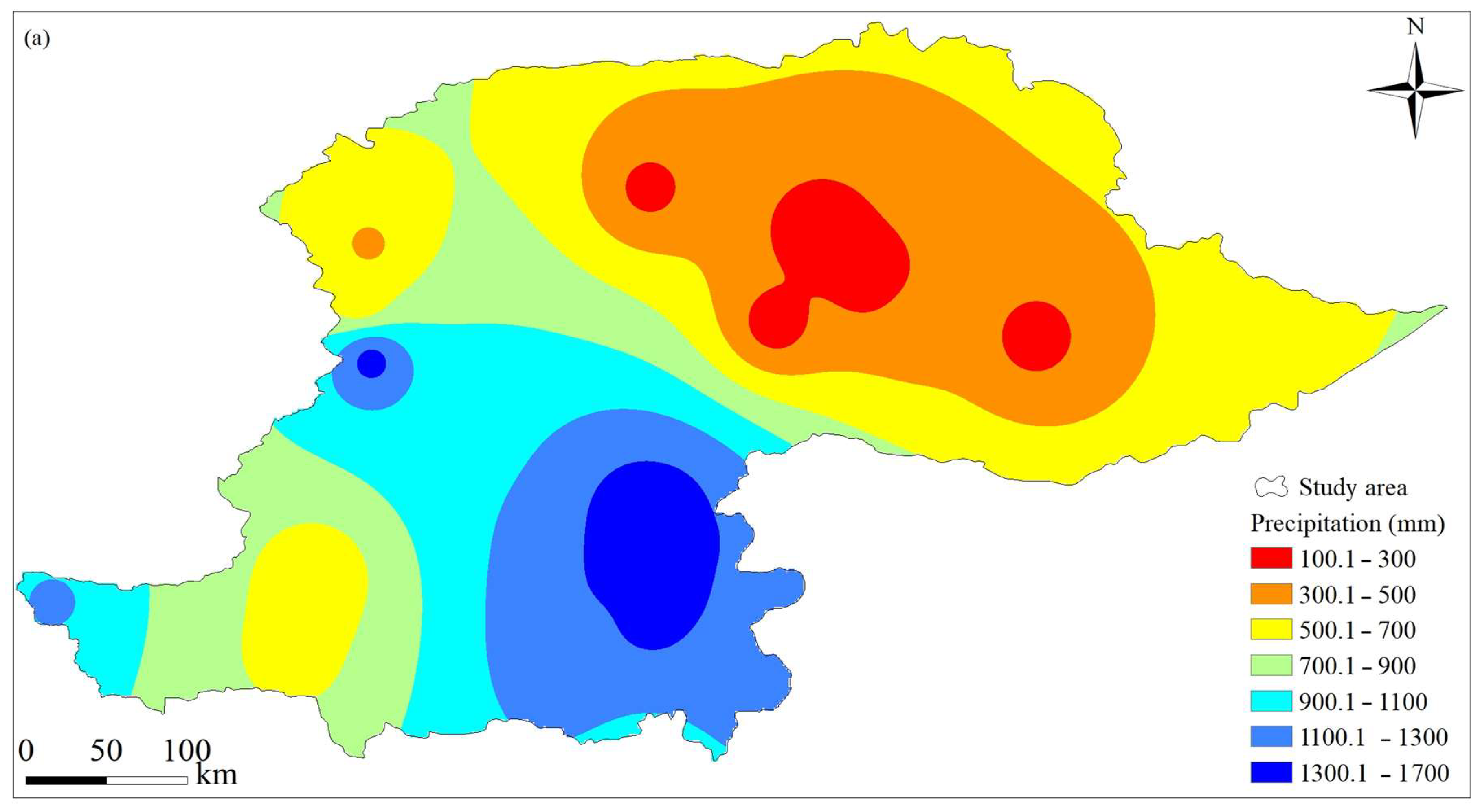
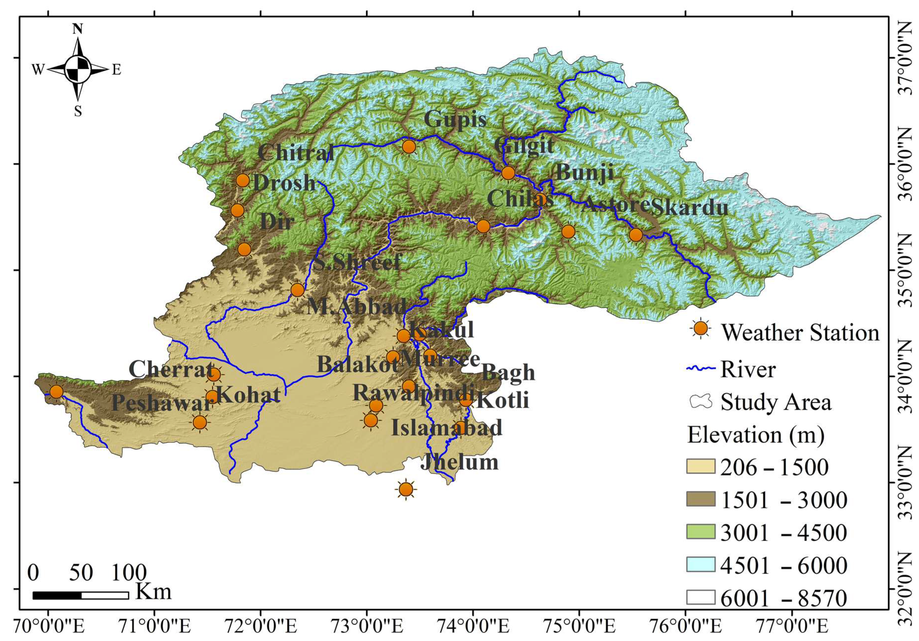
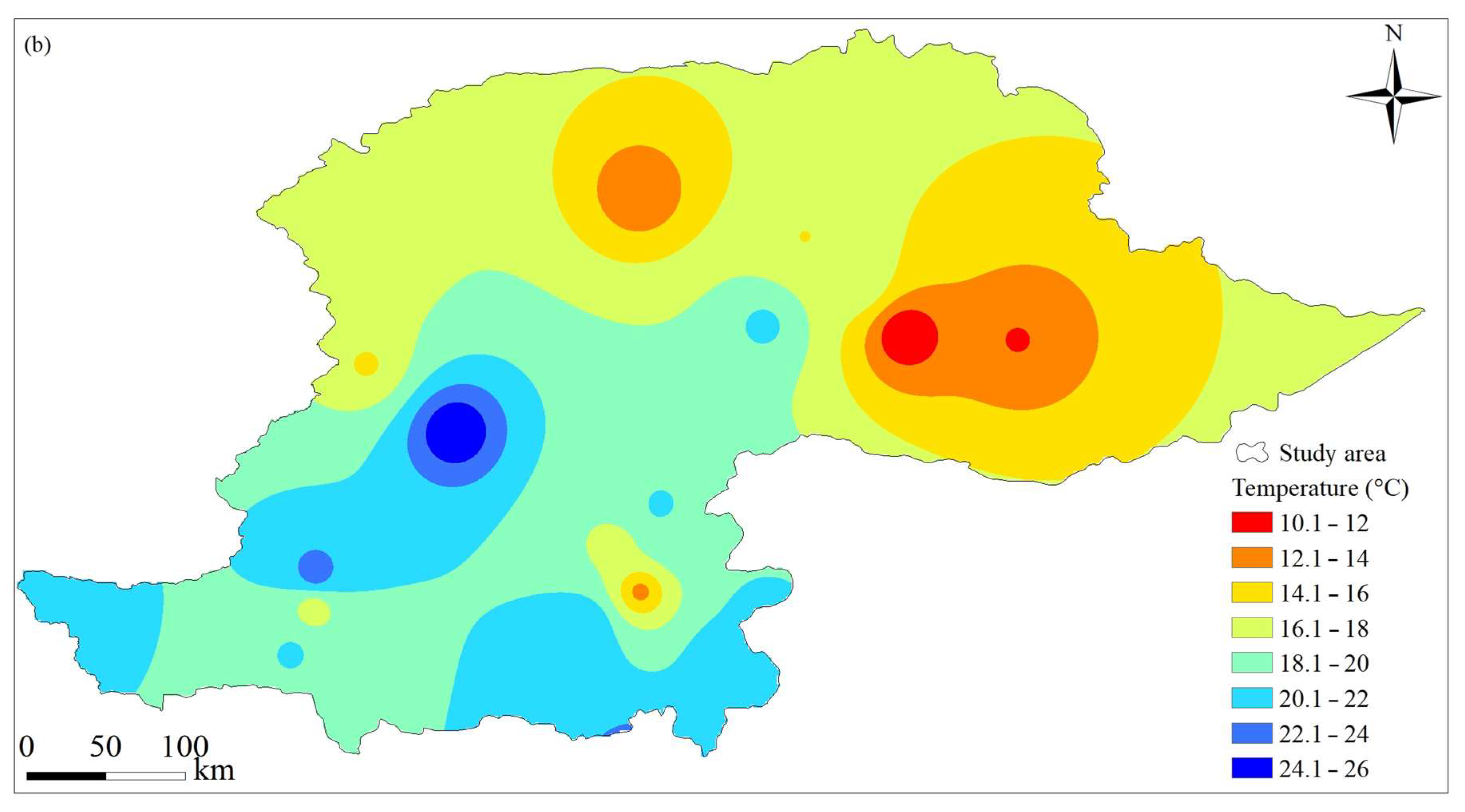
2.1. Study Area

The northern highlands of Pakistan contain a wide variety of topographical features, from mountainous regions to flat-topped plateaus and deep valleys. This area is distinguished by its distinctive topography, vast coverage of glaciers, and a wide range of climatic conditions, which significantly impact the local environment and regional natural resources. The spatial domain of the northern highlands of Pakistan (which covers geographic domain 33–37° N and 70–78° E) and the locations of weather stations are presented in Figure 1. Numerous glaciers and snow-capped mountains in this region are significant contributors to the local hydrology and water supply. Due to ongoing global warming, this region is most vulnerable to disasters such as flash floods and glacial lakes outburst floods (GLOFs). The climatic extremes, particularly temperature extremes, are expected to exacerbate risks of such disasters.
This part of the world is famous for its one-of-a-kind and delicate environment, which is exceptionally vulnerable to the effects of climate change. Due to its location at the confluence of the westerlies and the Indian monsoon system, this region has a complicated climate. Due to its elevation and topography, the local climate varies greatly. The amount of total annual precipitation received by this region varies from 100 mm to 1700 mm (Figure 2a), whereas the annual average temperature varies from 10 °C to 26 °C (Figure 2b). The region receives most of its precipitation during the monsoon season. The melting of snow and glaciers is the primary factor that determines how water flows through the region. The region is home to many glaciers, which serve as a significant water supply for the rivers that flow through the region. The glaciers in the NHP region are the source of the Indus River, one of Asia’s most important rivers.

2.2. Datasets

This research examines the spatiotemporal dynamics of extreme temperature (maximum and minimum) events over the last three decades (1991–2020). For the designed study period, daily data of maximum and minimum temperatures recorded at 24 weather stations across the northern mountainous domain of Pakistan were collected from Pakistan Meteorological Department (PMD). Annual means of maximum and minimum temperature were obtained from the daily data. Strict criteria were applied to the selection of station data for use in evaluating extreme climatic indices. The following criteria were followed in this study: (i) a monthly dataset was regarded as complete if there were no more than five missing days; (ii) a yearly dataset was considered as complete if all of its months were complete per previous criterion (i); (iii) a station’s data was regarded as complete if it included no more than five missing years in its whole data. PMD previously guaranteed the consistency and accuracy of the data [31]. Moreover, RClimDex 1.0 software was used to ensure the quality of considered datasets. A threshold, three times of estimated standard deviation, was defined to identify the outliers in the time series data. The details of weather stations considered for this study are shown in Table 1.

2.3. Trends Analysis of Extreme Temperature Indices

The modified Mann–Kendall (MMK) test was used in this study to determine changes in the extremes of minimum and maximum temperatures in northern Pakistan. The MMK test is a non-parametric statistical technique widely used to identify trends in time series data. The test is an expansion of the original MK test and has the potential to be used to consider serial correlations as well as seasonal influences in the data. Hamed and Rao made modifications to the MK test in 1998 [32] by including the corrected variance of the Mann–Kendall statistics S.
The significance of the result is calculated by comparing the actual value of the test statistic with its expected value under the null hypothesis of no trend. The MMK test is an effective technique for trend analysis, especially when the data are non-normal, or the trend is not linear. Since it does not need the estimation of any parameters, it is also beneficial when dealing with incomplete or missing data. In addition, the test may be used for both short-term and long-term datasets, which makes it a versatile and reliable tool for identifying trends in time series data. The following equations can be used to determine the value of S, the standardized test statistic Z, the variance V(S), and the corrected variance V*(S):
S = j = 1 n 1 k = j + 1 n sgn ( x k x j )
s g n   x k x j = 1           i f   x k x j > 0   0           i f   x k x j = 0 1         i f   x k x j < 0
  V ( S ) = n ( n 1 ) ( 2 n + 5 ) t t ( t 1 ) ( 2 t + 5 ) / 18
  V ( S ) = V ( S ) C o r
where
C o r = 1 + 2 n ( n 1 ) ( n 2 ) i = 1 n 1 ( n 1 ) ( n i 1 ) ( n i 2 ) ρ s ( i )
Z = S 1 V S             i f   S > 0 0                             i f   S = 0 S + 1 V S             i f   S < 0
where time series values are denoted by xj and xk, with k > j. n represents the total number of recordings, t represents the total length of time., and ρs(i) is the statistically significant autocorrelation function of the ranks of recordings. Z values greater than zero indicate an upward trend, whereas values less than zero indicate a downward trend. The significance of a trend was assessed at 5% significance level. The Theil–Sen slope (TS) estimator, non-parametric method, was utilized to obtain a reliable estimate of the trend’s slope. The following equation was used to determine the slope, as stated in the TS method:
T i = a j a k j k : f o r   i = 1,2 , , N
where the sequential data values at j and k time steps (where j > k) are denoted by a j and a k , respectively. The median of N values of Ti (ordered series) gives the slope of TS slope estimator.
Q i = T N + 1 2                                               i f   N   i s   o d d 1 2 T N 2 + T ( N + 2 ) 2       i f   N   i s   e v e n
Many different approaches have been developed to identify and classify temperature extremes. In this work, we employed a yearly examination of trends in indices of extremes in daily maximum (TMAX) and minimum (TMIN) temperatures to assess these shifts in extreme events. Spatial patterns were studied by examining them station-by-station and mapping the findings.

2.4. Extreme Temperature Indices

Table 2 explains the 13 minimum and maximum temperature indices defined by the “Expert Team on Climate Change Detection and Indices (ETCCDI)” working group. These indices can be found at http://etccdi.pacificclimate.org/list_27_indices.shtml (assessed on 2 January 2023) and were utilized in numerous studies of climatic extremes [33]. By following Alexander et al. [34], the extreme temperature indices were divided into three categories depending on the situation: (i) percentile, (ii) absolute, and (iii) duration-based indices.
The duration indices, in general, are used to characterize periods of extreme coldness (CSDI) and warmth (WSDI). The number of warmer or colder days than the highest and lowest long-term percentiles, respectively, were used to define the percentile-based indexes. These indices take into account the frequency with which cold days (TX10p), cold nights (TN10p), warm days (TX90p), and warm nights (TN90p) occurred. Maximum and minimum annual values were shown using absolute indices. The annual maximum of daily maximum temperature (TXx), annual maximum of daily minimum temperature (TNx), annual mean of maximum temperature (TXmean), annual mean of minimum temperature (TNmean), and daily temperature range (DTR) were all part of this dataset.
In this study, spatial interpolation was performed using the Kriging Interpolation method. Kriging is a geostatistical method that estimates values at sites that were not directly measured by taking into account the spatial correlation between data points.

3. Results

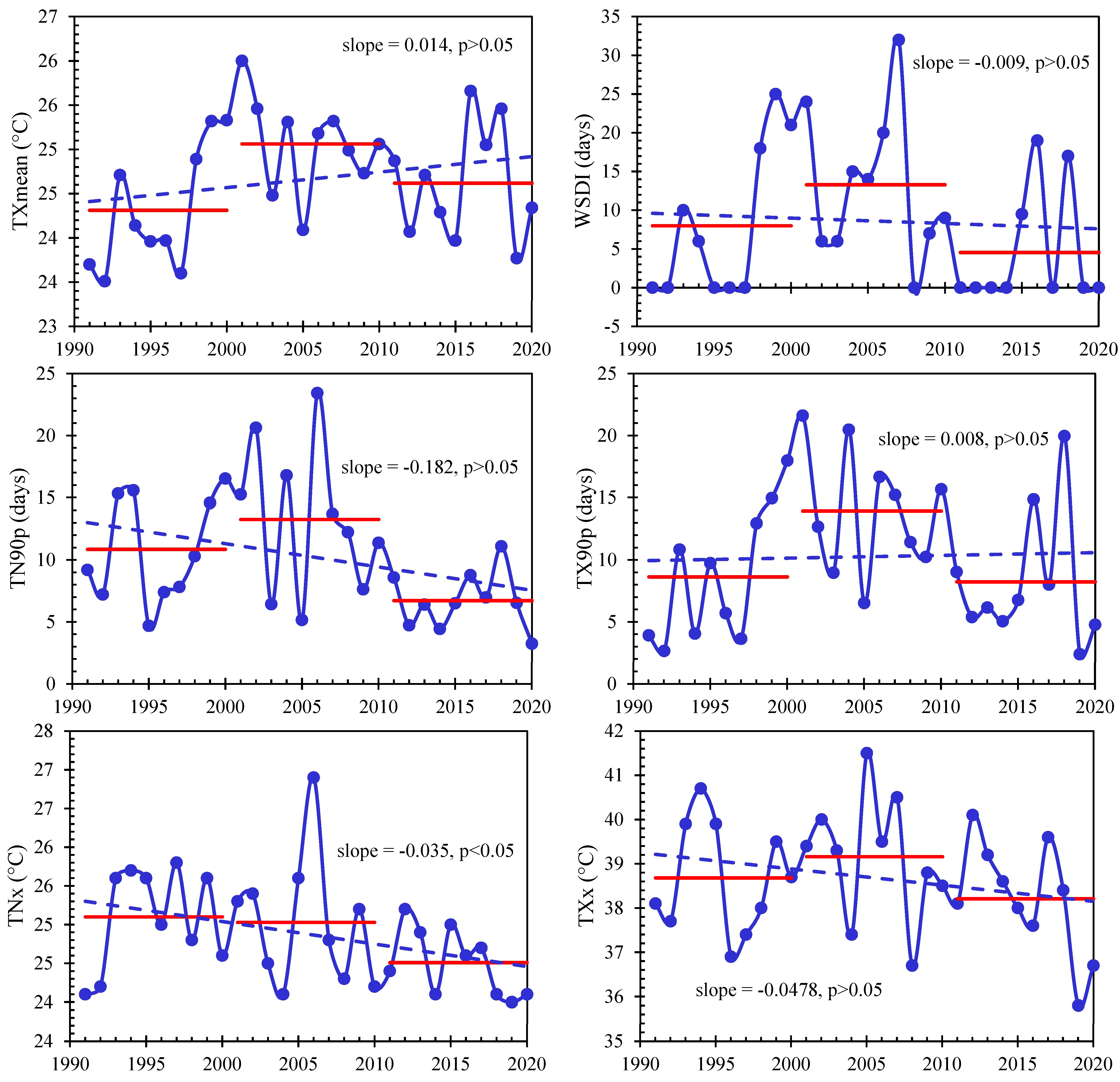
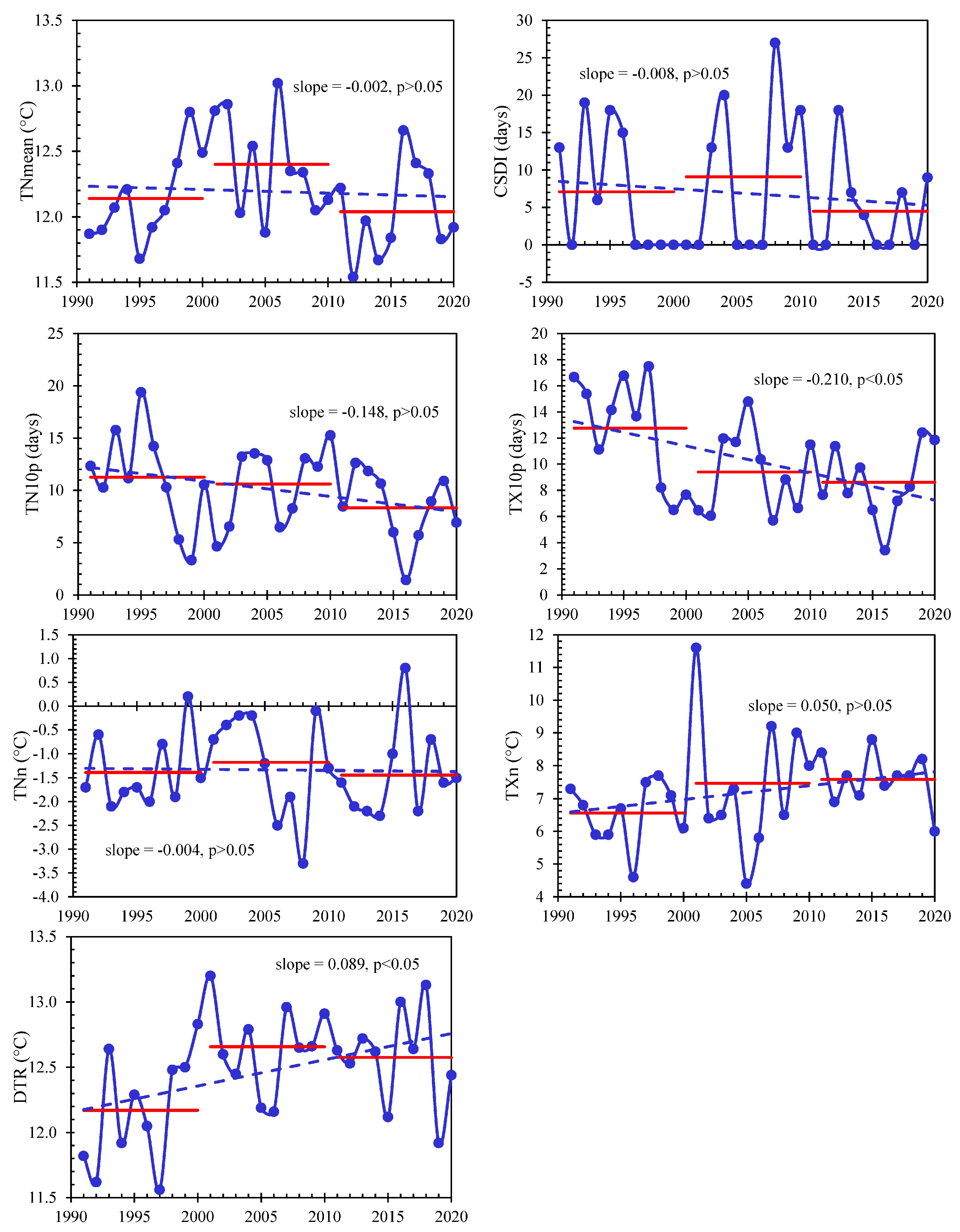
3.1. Temporal Variations in Extreme Temperature Indices

Figure 3 shows the temporal variations in the areal averaged hot extremes in the northern highlands of Pakistan during 1991–2020. The results indicate that, during the last 30 years, two hot indices (TXmean and TX90p) showed increasing tendencies at the rates of 0.14 °C/decade and 0.08 d/decade, respectively; however, the increasing tendencies were not statistically significant (at the 5% significance level). In contrast, all the other hot indices (WSDI, TN90p, TNx, and TXx) showed decreasing tendencies (at the rates of −0.09 d/decade, −1.82 d/decade, −0.35 °C/decade, and −0.48 °C/decade, respectively) over the past 30 years. Among all the hot indices, only one index (TNx) showed a significantly decreasing trend (p < 0.05). The decreasing trend of TNx during the past three decades indicated that the average temperature of the hottest night in the northern highlands of Pakistan was significantly decreased. Generally, the decadal average values of the hot indices were highest in the second decade (2001–2010), except for the TNx index, which showed its highest average in the 1990s and lowest in the 2010s. Overall, the decadal average values of all the hot indices consistently decreased during the past two decades. Table 3 shows the rates of the per decade changes in the hot and cold indices. The results indicated that all hot indices, except TXx, increased in the first decade (1990s). Two indices (TXmean and TX90p) showed significantly increasing trends (p < 0.05) at the rates of 1.70 °C/decade and 13.81 d/decade, respectively. However, no increasing trend in the hot indices was found in the second decade (2000s).
Figure 4 shows the linear trends in the cold indices over the past three decades (1991–2020). It was found that five cold indices (TNmean, CSDI, TN10p, TX10p, and TNn) decreased over the past three decades at the rates of −0.02 °C/decade, −0.08 d/decade, −1.48 d/decade, and −0.04 °C/decade. The decreasing trend of TX10p was statistically significant (p < 0.05), which showed that the frequency of annual average cold days was decreased in the NHP. On the other hand, two cold indices (TXn and DTR) increased at the rates of 0.50 °C/decade and 0.19 °C/decade, respectively, during the period of 1991–2020. The increasing rate of DTR was statistically significant (p < 0.05). The decadal average values of all cold indices, except for TXn, consistently decreased over the past two decades (2000s and 2010s). A trend analysis of the decadal times series of the cold indices indicated that the TNmean index significantly increased in the first decade (1990s), whereas it showed increasing and decreasing tendencies in the second and third decades (2000s and 2010s), respectively. However, the trends in the second and third decades were not significant at the 5% significance level. In the first decade, the CSDI index decreased at the highest rate (−13.33 d/decade), followed by TX10p and TN10p at the rates of −9.65 d/decade and −8.28 d/decade, respectively. However, these decreasing rates were not significant (p > 0.05). Conversely, CSDI showed the highest increasing rate in the second decade, at the rate of 16.25 d/decade. The DTR index increased during the first and second decades. Therefore, the overall increasing trend of the DTR index during the period of 1991–2020 might be due to the increasing tendency of this index during the 1990s and 2000s. The TX10p consistently decreased during the 1990s and 2000s but increased in the 2010s. The overall decreasing trend of TX10p during 1991–2020 might be due the decreasing trend of this index during the first and second decades of the study’s duration.
Table 4 presents the MMK test results of six hot indices measured at 24 weather stations in northern Pakistan. The frequency and severity of extreme events and climatic shifts can be measured with these indexes.
The first index, WSDI, assesses how long warm spells last. A high value of the MMK test for the WSDI indicates an increase in the number of days with warm spells. Significantly increasing warm spells were observed at two stations, Cherat and Garhi Dupatta, as shown by their high WSDI values. The values of the MMK test of the WSDI for all other stations were non-significant at the 5% significance level.
The second index, TX90p, is the number of days for which the high temperature was at least the 90th percentile. More intense heat waves can be expected at higher TX90p levels. Five stations (Balakot, Cherat, Dir, Garhi Dupatta, and Kakul) showed significantly high values of TX90p, which indicates that they witnessed an increase in the frequency of hot days. However, two stations (Para Chinar and Skardu) exhibited a significantly decreasing trend of TX90p. Compared to the other 24 stations, the value of the MMK test for TX90p at the Cherat station was the highest (Z = 4.05), indicating that it observed the highest number of hot days. On the other hand, the value of the MMK test for the TX90p index at the Skardu (Z = −2.62) station showed that it experienced a significant decrease in the frequency of hot days.
The third index is referred to as TN90p, and it determines the percentage of days with minimum temperatures higher than the 90th percentile. High values of the MMK test for the TN90p indicate an increase in the frequency of exceptionally warm nighttime temperatures. However, when the MMK test value of TN90p is negative, it indicates a decrease in the frequency of hot nights. Most stations showed a decline in the frequency of TN90p, as indicated by the negative MMK test values of TN90p. Among the 24 stations, the frequency of hot nights significantly increased only at Bunji (Z = 2.84), while it significantly decreased at Drosh (Z = −4.30), Skardu (Z = −3.13), Balakot (Z = −2.87), Gahri Dupitta (Z = −2.55), Muzaffarabad (Z = −2.53), Kakul (Z = −2.45), Kohat (Z = −2.40), Chilas (Z = −2.14), and Dir (Z = −2.12).
TXx, the hottest day of the year, is the fourth temperature index. An increase in heatwave intensity is reflected by higher TXx values. The value of the MMK test for the TXx index was the highest at the Bunji station, which suggests that the location was subjected to more severe heat waves. The majority of stations, however, reported a declining TXx trend.
The fifth index, TNx, represents the hottest night in a year. Higher TNx levels indicate that warm nights are becoming more intense. In contrast, cooler nights are forecast when TNx readings are negative. In the NHP, most of the stations showed a decreasing tendency of the hottest nights. A significantly decreasing trend of TNx was found at Bagh, Bala Kot, Drosh, Gahri Dupitta, Kakul, Kohat, and Muzaffarabad. However, the MMK test values showed a significantly increasing trend of the hottest night at two locations (Astore and Skardu, with Z values of 2.32 and 2.00, respectively).
TXmean, a measure of the mean daily maximum temperature, is the sixth index. It was found that TXmean was significantly increased at six locations including Bala Kot (Z = 3.64), Cherat (Z = 4.66), Chilas (Z = 2.04), Gahri Dupitta (Z = 2.67), Kakul (Z = 2.41), and Kotli (Z = 2.33). However, Txmean was significantly decreased at Peshawar, as indicated by the lowest value of Z (−2.19).
Table 4 demonstrates how extreme weather events changed at different sites throughout northern Pakistan. There was an increase in the frequency of hot days and heat waves at some stations and a decrease in the frequency of hot nights at others. These shifts can significantly impact the environment, human health, and agricultural practices.
Table 5 displays the MMK test statistics for cold extremes. According to the results of the MMK test, the CSDI was significantly increased at three locations (Dir, Drosh, and Para Chinar), with Z values of 2.22, 2.22, and 2.59, respectively. These locations experienced an increase in the frequency of cold spells. In contrast, cold spells were significantly decreased at three other locations (Gilgit, Jhelum, and Kotli), and the values of Z at these locations were −2.34, −3.13, and −2.42, respectively. This finding indicated that these locations experienced fewer cold spells than the other locations.
The TX10p index measures the number of days per year when the location’s annual maximum temperature is at or below the temperature’s 10th percentile. According to the results of the MMK test, the TX10p index was decreased at most of the stations, indicating that the incidence of cold days was decreasing at these locations. However, there were a few locations where the value of the TX10p index was positive, suggesting an increase in the frequency of cold weather. Overall, TX10p and TN10p showed a decreasing trend, as indicated by the negative values at the majority of the stations.
Generally, the statistical values of the MMK test for the TXn index showed an increasing trend. This increasing trend was statistically significant at Astore, Bala Kot, Kotli, Parachinar, and Skardu. Several locations showed a decreasing trend in the TNn. Significant negative trends of TNn were found for Bagh, Chilas, Drosh, Garhi Dupatta, Islamabad, Jhelum, and Muzaffarabad. On the other hand, some stations (Para Chinar, Dir, and Murree) showed a significantly increasing trend of TNn (with values of Z > 1.96), indicating a significant increase in the frequency of the coldest nights. The remaining stations indicated an insignificant trend in the frequency of the coldest nights (TNn).
Overall, TNmean showed a decreasing tendency over the past 30 years. A significantly decreased trend of TNmean was found at five stations (Bala Kot, Drosh, Murree, Para Chinar, and Skardu). Conversely, the trend of TNmean was statistically significant at three locations (Bunji, Chitral, and Gilgit). The findings of the MMK test of DTR showed that it was significantly increasing at 10 stations. In contrast, two stations (Bunji and Gilgit) showed significantly decreasing trends in DTR. The trend of DTR was not significant at 12 locations.
To check the changes in temperature extremes for the time span between 1991 and 2020, the spatial patterns of the trend for the past 30 years’ set of indicators were investigated.

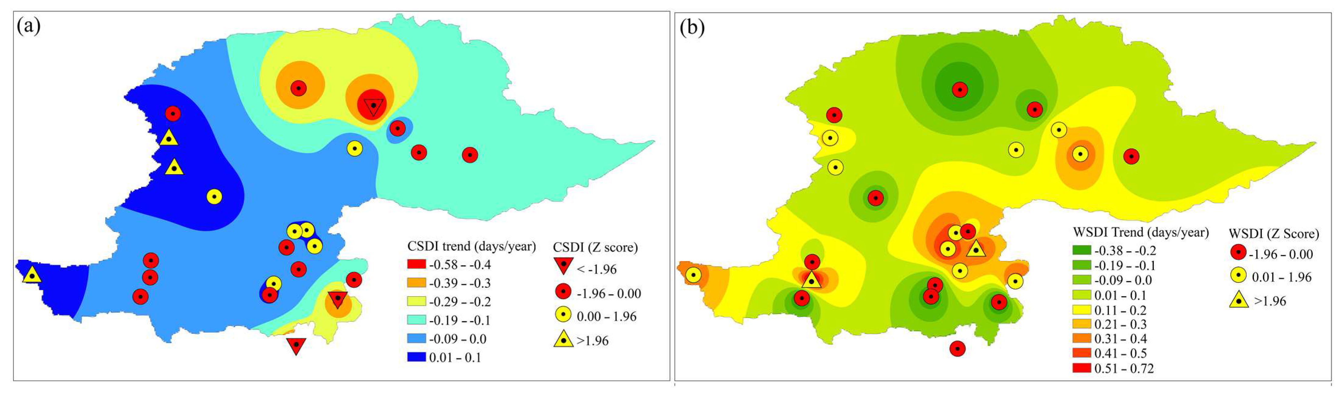
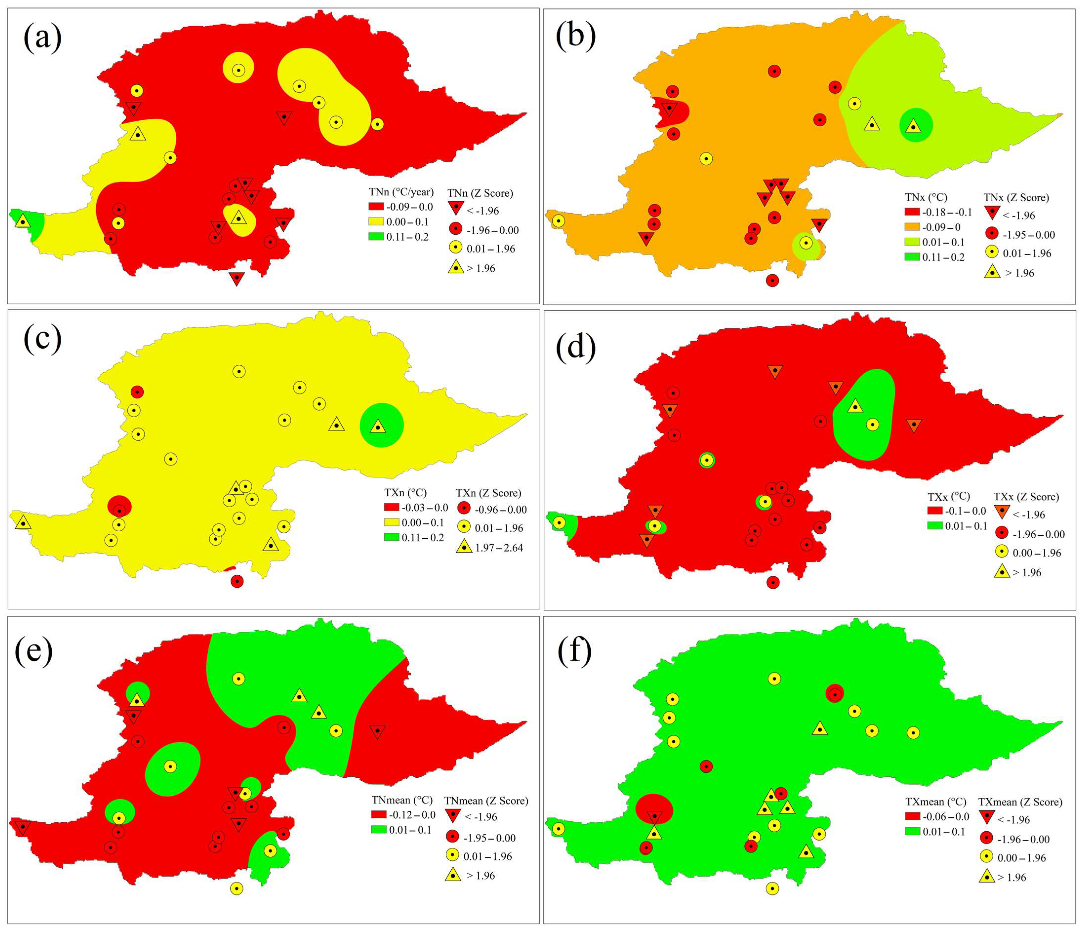
3.2. Spatial Changes in Duration-Based Extreme Temperature Indices

Figure 5 displays the spatial distributions of the magnitudes of the annual average changes in the CSDI and WSDI indices in northern Pakistan. The spatial distribution of the trend of the CSDI index showed that the total number of cold days was slightly decreasing over the whole study region, and the rate of decrease was relatively higher in the northern parts compared to the southern parts. According to the spatial distribution of the CSDI index values, most of the parts of the study area, particularly the northern parts, were subjected to fewer cold spells. In contrast, the other regions, particularly the southern regions, were subjected to a decrease. The spatial variability map of the trend of the WSDI index showed that the frequency of warm days increased in most parts of the study area. Particularly, the increasing rate was more prominent in the central part of the study domain, as exhibited by the spatial variability map of the WSDI index. The spatial distribution of the WSDI index values suggested that some regions in the area are more vulnerable to heat stress than others.

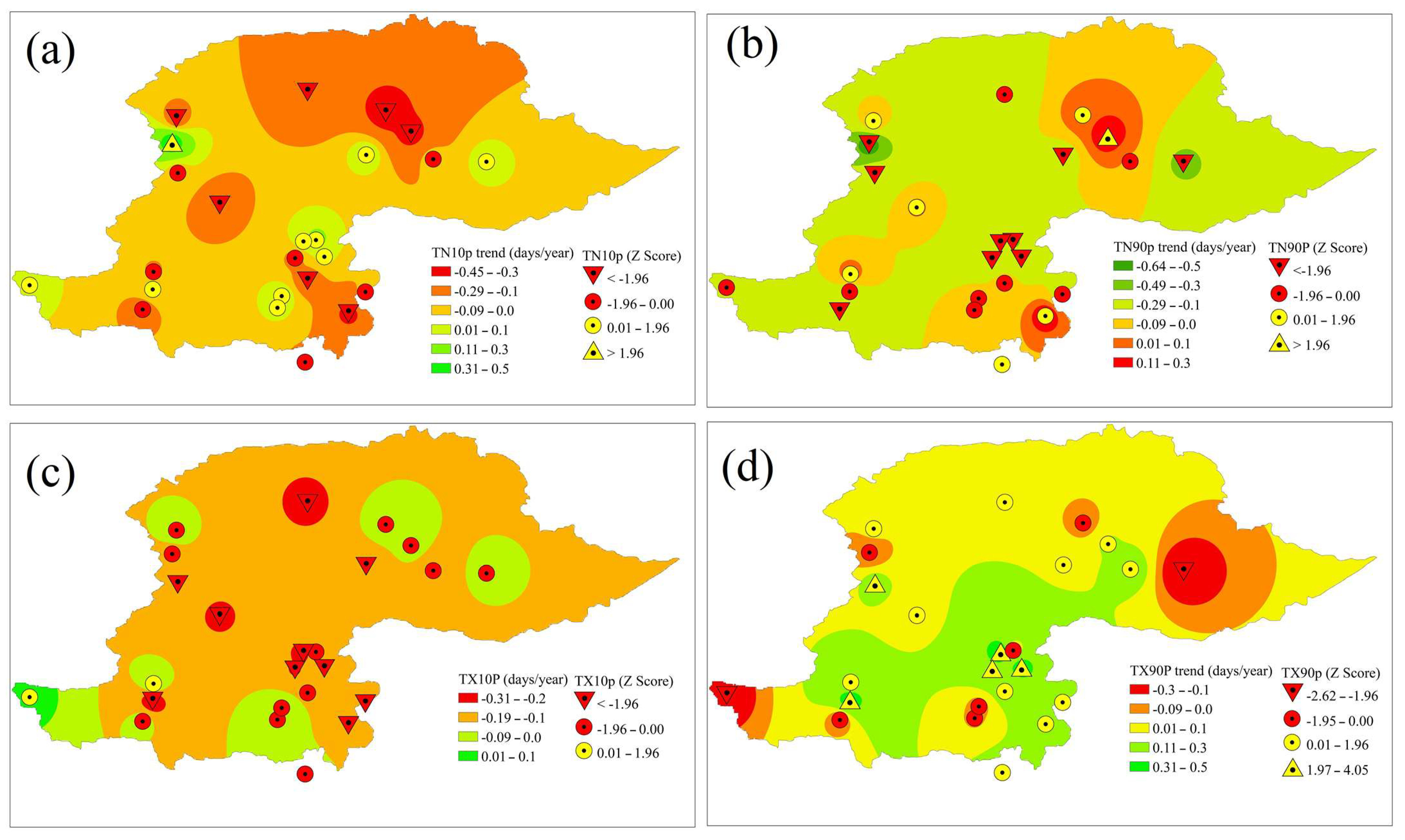
3.3. Spatial Changes in Percentile-Based Extreme Temperature Indices

By plotting the rate of change in TN10p values across northern Pakistan (Figure 6a), it was noticed that most stations exhibited a negative rate of change, suggesting a declining trend in the occurrence of cold nights over the last 30 years. This pattern was most pronounced in northern locations like Gilgit, Gupis, and Kotli. However, few locations indicated a positive rate of change, suggesting an increasing trend in the frequency of cold nights. The regional distribution of the rate of change in TN10p values indicated a general trend toward fewer cold nights across the study domain. However, a significant increase in the number of cold nights (indicated by a positive index value (p < 0.05)) was found at the Para Chinar station. There was no clear pattern in the increasing or decreasing frequency of cold nights at southern and central stations such as Islamabad, Jhelum, Kohat, Kotli, M. Abad, Murree, Peshawar, Rawalpindi, and Saidu Sharif. At these locations, a decline in the index value indicated a corresponding decline in the trend of cold nights, while an increase in the index value indicated an equivalent increase in the trend of cold nights. It was deduced that the frequency of cold nights was decreased in the northern areas, while mixed patterns were found in the central and southern areas.
The regional distribution of the TN90p index values revealed considerable variation in the occurrence of extremely hot nights at various locations. Over the reference period, the frequency of extremely hot temperatures increased at some locations. The majority of the sites with positive TN90p values, such as Bunji, Gilgit, and Kotli, were located in the northern parts of the NHP. The highest positive value of the MMK test results (p < 0.05) was found at the Bunji station, where the increasing rate was 0.30 days/year. The southern parts of the study area, including Islamabad, Rawalpindi, and Murree, were experiencing a decreasing trend for TN90p. The highest decreasing rate (0.64 days/year) of the TN90p index was found at the Drosh station in the northwestern part of the NHP. The spatial distribution of the TN90p index values suggested that the annual percentage of hot nights was increasing in the northeastern parts of the study domain, while in most of the other parts of the NHP.
The frequency of cold days (TX10p) was decreased at most of the stations in the entire study area, as reflected by the spatial distribution of the values of the MMK test and the TS estimator for the TX10p index (Figure 6c). Most of the stations in the study area showed positive values for the MMK test and the TS estimator for the TX90p index, suggesting a rise in the frequency of hot days in the NHP, as seen by the spatial distribution of the index. However, the results of the MMK test showed that the TX90p index was significantly decreasing at two locations, indicating that hot days were becoming less frequent in the northeastern and southwestern parts of the NHP. Some stations in the southern parts of the study area showed negative values for the index, showing a similar trend of decreasing extremely hot days.

3.4. Spatial Changes in Absolute Extreme Temperature Indices

Figure 7 explains the spatial distributions of the magnitude of changes in six absolute indices in northern Pakistan. The spatial distribution of the trend rate in the TNn index (Figure 7a) showed that most stations had negative values, suggesting a declining trend in the coldest nights in northern Pakistan. Most of the negative values (at the rate of −0.09 °C to 0.0 °C) were found in the northern sites, indicating a decreasing minimum (nighttime) temperature in that part. The opposite was true for some of the stations in the southwestern parts, where positive values indicated that the minimum temperature was rising. The spatial distribution of the rate of TNx (Figure 7b) trend revealed that the annual average temperature of the hot nights was generally decreasing. The maximum decreasing rate was −0.18 °C/year.
The spatial distribution of the annual minimum value of the maximum temperature (TXn) was increasing at most of the locations (Figure 7c). Conversely, the annual maximum value of the maximum temperature (TXx) was decreasing at most of the locations in the study area, as indicated by the spatial distribution of the TXx index (Figure 7d). The annual average of the minimum temperature index (TNmean) was decreasing at most the stations, with the maximum decreasing rate of −0.12 °C/year. In contrast, the annual average of the maximum temperature index (TXmean) was increasing at most the stations, with maximum increasing rate of 0.1 °C/year.

4. Discussion

We analyzed the temporal and spatial evolution of extreme climate events in the northern highlands of Pakistan during 1991–2020 by selecting the indices of extreme temperature. Our study built on previous research conducted in different geographical areas around the world, which documented a rise in both the frequency and severity of the events of hot days [8,35,36,37]. By analyzing these indices, we found that the northern highlands of Pakistan have experienced an increase in hot days over the past 30 years. This finding was consistent with the results of Saleem et al. [27]. The results of our investigation exhibited that the daily maximum temperature increased over the NHP during the past three decades, which was in line with the findings of Hussain et al. [37] in the Karakoram region of Pakistan. Another study by Syed et al. [38] analyzed the trends in extreme temperatures in Pakistan and reported an increase in the frequency and severity of heatwaves. Our findings were consistent with their results, as we also found an increase in the frequency of extremely hot days at some stations.
Although two hot indices (hot days and the mean of the daily maximum temperature) were increasing over the past three decades, the other hot indices (hot nights, the hottest nights, the hottest days, and the warm spell duration index) were decreasing over the same study duration in the NHP. This can be explained by the distinct dynamics that mountain climates exhibit, as well as the complex interactions that take place between atmospheric and geographical aspects. The terrain and altitudes of mountainous areas are distinctive. Variations in the warming tendencies between the day and night can be caused by an elevation effect on the temperature patterns. While global warming may cause an increase in the average daily maximum temperature, the nighttime cooling impact of higher elevations may lead to a reduced number of annual average hottest days. Radiative cooling may be another potential explanation for this pattern. Radiative cooling at night increases in the mountains due to the clear sky and low humidity [39]. Therefore, it is possible for nighttime surface and air temperatures to dramatically drop, mitigating the general warming trend and resulting in a reduced number of the hottest nights.
Despite the fact that the coldest days were increasing over the past three decades in the NHP, it was found that the coldest nights, cold nights, cold days, and average of daily minimum temperature decreased over the same study period. The results of the MMK test showed that several stations, such as Garhi Dupatta, Muzaffarabad, and Islamabad, experienced a decreasing trend in the annual minimum temperature. These findings were in line with those found in an earlier study carried out by Yaseen et al. [40], which showed that the minimum temperature has decreased in northern Pakistan over the past few decades. This decreasing trend of the minimum temperature, cold nights, cold days, and cold spell duration might be due to a combination of general climate trends and mountain-specific mechanisms. The overall cooling tendencies and increased temperature variability associated with higher elevations might be the reasons for the increase in the coldest days. In addition, high-pressure systems and atmospheric blockage, both of which occur on a continental scale, can have an impact on temperature extremes in mountainous regions. The spatial variations and strength of these systems can result in changes in the air masses and the temperature characteristics that are connected with these air masses. The length of cold spells, the coldest days, and the number of cold nights may have all decreased over the previous two decades due to changes in circulation patterns. A probable additional factor in the recent downward trend of cold nights, cold days, and cold spell duration is the diminishing snow cover in the northern parts of Pakistan [11]. During the winter months, considerable snow cover is prevalent in mountainous areas. The local energy balance and temperature profiles can be affected by changes in snow cover and surface albedo (reflectivity). Reduced snow cover or altered snow qualities, like a lower albedo from dust deposition, can increase surface heating and decrease the length of cold nights, cold days, and cold spells.
This study is important because it applies the cold and hot matrices to a particular highland regional setting. As a result, it provides distinctive insights into the processes that govern the occurrence of severe temperatures. It is important to be aware of the study’s limitation, which is the relatively short 30-year period record of temperature. The reported rise in the frequency of hot days and cold spell patterns is the practical ramifications. Despite noting this limitation, which includes the use of a case study approach and the limitation imposed by the length of the record, this research emphasizes its importance in highlighting the formation of strategies for climate adaptation and resilience. This study emphasizes the need for constant monitoring and well-informed decision making in the local context and similar situations.

5. Conclusions

The following findings were drawn from the investigation of temperature extremes in northern Pakistan over the period of the last three decades (1991–2020):
  • The number of hot days significantly increased in the study domain. Therefore, it was deduced that the hot weather events in northern Pakistan have become more frequent and severe in the past 30 years.
  • The annual maximum value of minimum temperature was significantly decreased in the study area during the past three decades.
  • The difference between the maximum temperature and minimum temperature was significantly increased in the northern highlands of Pakistan during 1991–2020.
  • Overall, a decreasing trend in the annual average number of cold days and cold nights was detected in the NHP.
  • Only two hot indices (TXmean and TX90p) showed increasing tendencies, although their trends were not statistically significant.
  • The decadal averages of all the hot indices, except for TNx, were highest in the second decade (2001–2010) and consistently lowest in the last decade (2011–2020).
  • Most of the stations installed in the study domain demonstrated a decreasing trend in the level of heatwave intensity, which is reflected by the TXx index.
  • The duration and frequency of cold spells increased at the Dir, Drosh, and Para Chinar locations but decreased in the central and southern parts of the study domain. These changes might be attributed to changes in large-scale atmospheric circulation patterns.
  • Most of the locations in the NHP indicated an increase in the number of days with below-average temperatures. Nevertheless, there were indications of a decrease in cold weather in some areas.
Overall, this study shows significant changes in the extreme weather patterns in northern Pakistan, including longer periods of cold weather in some regions and an increase in both the severity and frequency of hot extreme weather events. The results of this investigation have important implications for regional disaster risk reduction strategies, particularly for the China Pakistan Economic Corridor (CPEC). The trends observed in the extreme temperature indices emphasize the critical importance of taking immediate action to adapt to and mitigate the effects of climate change. The combination of the slightly increasing trend in the annual maximum temperature and the downward trend in the annual minimum temperature may have far-reaching effects on a variety of sectors, including food production, human health, and the environment. In addition, an increase in the number of days with extremely high temperatures and a decrease in the number of nights with extremely high temperatures emphasize the significance of developing effective strategies to maintain resilience and sustainability in the face of shifting climatic trends. In light of these results, we urge decision makers and relevant parties in northern Pakistan to act decisively to mitigate the effects of climate change.

Author Contributions

Conceptualization, A.A.J.G., M.N.A., G.R. and S.; data curation, M.N.A., M.I., M.A. and U.M.N.; formal analysis, M.N.A. and G.R.; funding acquisition, A.A.J.G., M.I., M.A. and S.R.; investigation, M.N.A.; methodology, M.N.A., G.R. and S.; project administration, A.A.J.G., M.N.A., M.I. and M.A.; resources, S.R. and U.M.N.; software, M.N.A. and G.R.; supervision, M.N.A. and A.A.J.G.; validation, G.R. and S.; visualization, A.A.J.G., M.I., M.A. and S.R.; writing—original draft, M.N.A.; writing—review and editing, A.A.J.G. and M.N.A. All authors have read and agreed to the published version of the manuscript.

Funding

This research was funded by the Institutional Funding Committee at Najran University, the Kingdom of Saudi Arabia.

Institutional Review Board Statement

Not applicable.

Informed Consent Statement

All authors have consented to the acknowledgment.

Data Availability Statement

Not applicable.

Acknowledgments

The authors would like to acknowledge the support of this research by the Deputy for Research and Innovation Ministry of Education, the Kingdom of Saudi Arabia, through grant number (NU/IFC/2//SERC/-/2) under the Institutional Funding Committee at Najran University, the Kingdom of Saudi Arabia.

Conflicts of Interest

The authors declare no conflict of interest.

References

  1. Intergovernmental Panel on Climate Change. Climate Change 2021: The Physical Science Basis: Summary for Policymakers Working Group I Contribution to the Sixth Assessment Report of the Intergovernmental Panel on Climate Change; IPCC: Geneva, Switzerland, 2021; ISBN 9789291691586. [Google Scholar]
  2. Ghanim, A.A.J.; Anjum, M.N.; Rasool, G.; Saifullah; Irfan, M.; Rahman, S.; Mursal, S.N.F.; Niazi, U.M. Assessing Spatiotemporal Trends of Total and Extreme Precipitation in a Subtropical Highland Region: A Climate Perspective. PLoS ONE 2023, 18, e0289570. [Google Scholar] [CrossRef] [PubMed]
  3. Abbas, S.; Kousar, S.; Khan, M.S. The Role of Climate Change in Food Security; Empirical Evidence over Punjab Regions, Pakistan. Environ. Sci. Pollut. Res. 2022, 29, 53718–53736. [Google Scholar] [CrossRef] [PubMed]
  4. Goddard, L.; Gershunov, A. Guidelines on Analysis of Extremes in a Changing Climate in Support of Informed Decisions for Adaptation; World Meteorological Organization: Geneva, Switzerland, 2009; WMO-TD No. 1–55; Available online: https://library.wmo.int/index.php?lvl=notice_display&id=138 (accessed on 2 January 2023).
  5. Anjum, M.N.; Ghanim, A.A.J.; Farid, H.U.; Zaman, M.; Niazi, U.M.; Rahman, S.; Alsaiari, M.A.; Irfan, M. Assessment of Climate Change and Its Impacts on the Flows of a Subtropical River Basin in the Hindu-Kush Mountain, South Asia. Pure Appl. Geophys. 2022, 179, 3841–3857. [Google Scholar] [CrossRef]
  6. Tahir, A.A.; Chevallier, P.; Arnaud, Y.; Ashraf, M.; Tousif, M. Snow Cover Trend and Hydrological Characteristics of the Astore River Basin (Western Himalayas) and Its Comparison to the Hunza Basin (Karakoram Region). Sci. Total Environ. 2015, 505, 748–761. [Google Scholar] [CrossRef]
  7. Muhammad Qasim, S.K. Hydro-Meteorological Characteristics of Indus River Basin at Extreme North of Pakistan. J. Earth Sci. Clim. Chang. 2014, 5, 170. [Google Scholar] [CrossRef]
  8. Xu, D.; Liu, D.; Yan, Z.; Ren, S.; Xu, Q. Spatiotemporal Variation Characteristics of Precipitation in the Huaihe River Basin, China, as a Result of Climate Change. Water 2023, 15, 181. [Google Scholar] [CrossRef]
  9. Abbas, S.; Yaseen, M.; Latif, Y.; Waseem, M.; Muhammad, S.; Leta, M.K.; Sher, S.; Imran, M.A.; Adnan, M.; Khan, T.H. Spatiotemporal Analysis of Climatic Extremes over the Upper Indus Basin, Pakistan. Water 2022, 14, 1718. [Google Scholar] [CrossRef]
  10. Khan, F.; Ali, S.; Mayer, C.; Ullah, H.; Muhammad, S. Climate Change and Spatio-Temporal Trend Analysis of Climate Extremes in the Homogeneous Climatic Zones of Pakistan during 1962–2019. PLoS ONE 2022, 17, e0271626. [Google Scholar] [CrossRef]
  11. Anjum, M.N.; Ding, Y.; Shangguan, D.; Liu, J.; Ahmad, I.; Ijaz, M.W.; Khan, M.I. Quantification of Spatial Temporal Variability of Snow Cover and Hydro-Climatic Variables Based on Multi-Source Remote Sensing Data in the Swat Watershed, Hindukush Mountains, Pakistan. Meteorol. Atmos. Phys. 2018, 131, 467–486. [Google Scholar] [CrossRef]
  12. Waseem, M.; Ajmal, M.; Ahmad, I.; Khan, N.M.; Azam, M.; Sarwar, M.K. Projected Drought Pattern under Climate Change Scenario Using Multivariate Analysis. Arab. J. Geosci. 2021, 14, 544. [Google Scholar] [CrossRef]
  13. Aslam, A.Q.; Ahmad, S.R.; Ahmad, I.; Hussain, Y.; Hussain, M.S. Vulnerability and Impact Assessment of Extreme Climatic Event: A Case Study of Southern Punjab, Pakistan. Sci. Total Environ. 2017, 580, 468–481. [Google Scholar] [CrossRef] [PubMed]
  14. Ali, S.; Liu, Y.; Ishaq, M.; Shah, T.; Abdullah; Ilyas, A.; Din, I. Climate Change and Its Impact on the Yield of Major Food Crops: Evidence from Pakistan. Foods 2017, 6, 39. [Google Scholar] [CrossRef] [PubMed]
  15. Bolch, T.; Kulkarni, A.; Kääb, A.; Huggel, C.; Paul, F.; Cogley, J.G.; Frey, H.; Kargel, J.S.; Fujita, K.; Scheel, M.; et al. The State and Fate of Himalayan Glaciers. Science 2012, 336, 310–314. [Google Scholar] [CrossRef] [PubMed]
  16. Liu, Y.; Hu, X.; Wu, F.; Chen, B.; Liu, Y.; Yang, S.; Weng, Z. Quantitative Analysis of Climate Change Impact on Zhangye City’s Economy Based on the Perspective of Surface Runoff. Ecol. Indic. 2019, 105, 645–654. [Google Scholar] [CrossRef]
  17. Yang, T.; Li, Q.; Chen, X.; De Maeyer, P.; Yan, X.; Liu, Y.; Zhao, T.; Li, L. Spatiotemporal Variability of the Precipitation Concentration and Diversity in Central Asia. Atmos. Res. 2020, 241, 104954. [Google Scholar] [CrossRef]
  18. Burić, D.; Doderović, M. Trend of Percentile Climate Indices in Montenegro in the Period 1961–2020. Sustainability 2022, 14, 12519. [Google Scholar] [CrossRef]
  19. Chen, A.; He, X.; Guan, H.; Cai, Y. Trends and Periodicity of Daily Temperature and Precipitation Extremes during 1960–2013 in Hunan Province, Central South China. Theor. Appl. Climatol. 2018, 132, 71–88. [Google Scholar] [CrossRef]
  20. Toll, V.; Post, P. Daily Temperature and Precipitation Extremes in the Baltic Sea Region Derived from the BaltAn65+ Reanalysis. Theor. Appl. Climatol. 2018, 132, 647–662. [Google Scholar] [CrossRef]
  21. Meseguer-Ruiz, O.; Ponce-Philimon, P.I.; Quispe-Jofré, A.S.; Guijarro, J.A.; Sarricolea, P. Spatial Behaviour of Daily Observed Extreme Temperatures in Northern Chile (1966–2015): Data Quality, Warming Trends, and Its Orographic and Latitudinal Effects. Stoch. Environ. Res. Risk Assess. 2018, 32, 3503–3523. [Google Scholar] [CrossRef]
  22. Insaf, T.Z.; Lin, S.; Sheridan, S.C. Climate Trends in Indices for Temperature and Precipitation across New York State, 1948–2008. Air Qual. Atmos. Health 2013, 6, 247–257. [Google Scholar] [CrossRef]
  23. Caloiero, T. Trend of Monthly Temperature and Daily Extreme Temperature during 1951–2012 in New Zealand. Theor. Appl. Climatol. 2017, 129, 111–127. [Google Scholar] [CrossRef]
  24. Touré Halimatou, A.; Kalifa, T.; Kyei-Baffour, N. Assessment of Changing Trends of Daily Precipitation and Temperature Extremes in Bamako and Ségou in Mali from 1961–2014. Weather Clim. Extrem. 2017, 18, 8–16. [Google Scholar] [CrossRef]
  25. Croitoru, A.E.; Piticar, A. Changes in Daily Extreme Temperatures in the Extra-Carpathians Regions of Romania. Int. J. Climatol. 2013, 33, 1987–2001. [Google Scholar] [CrossRef]
  26. Chapagain, D.; Dhaubanjar, S.; Bharati, L. Unpacking Future Climate Extremes and Their Sectoral Implications in Western Nepal. Clim. Chang. 2021, 168, 8. [Google Scholar] [CrossRef]
  27. Salman, S.A.; Shahid, S.; Ismail, T.; Ahmed, K.; Chung, E.S.; Wang, X.J. Characteristics of Annual and Seasonal Trends of Rainfall and Temperature in Iraq. Asia-Pac. J. Atmos. Sci. 2019, 55, 429–438. [Google Scholar] [CrossRef]
  28. Khan, A.J.; Koch, M.; Tahir, A.A. Impacts of Climate Change on Thewater Availability, Seasonality and Extremes in the Upper Indus Basin (UIB). Sustainability 2020, 12, 1283. [Google Scholar] [CrossRef]
  29. Du, H.; Xia, J.; Yan, Y.; Lu, Y.; Li, J. Spatiotemporal Variations of Extreme Precipitation in Wuling Mountain Area (China) and Their Connection to Potential Driving Factors. Sustainability 2022, 14, 8312. [Google Scholar] [CrossRef]
  30. Zhang, X.; Zwiers, F.W.; Li, G.; Wan, H.; Cannon, A.J. Complexity in Estimating Past and Future Extreme Short-Duration Rainfall. Nat. Geosci. 2017, 10, 255–259. [Google Scholar] [CrossRef]
  31. Anjum, M.N.; Irfan, M.; Waseem, M.; Leta, M.K.; Niazi, U.M.; Rahman, S.U.; Ghanim, A.; Mukhtar, M.A.; Nadeem, M.U. Assessment of PERSIANN-CCS, PERSIANN-CDR, SM2RAIN-ASCAT, and CHIRPS-2.0 Rainfall Products over a Semi-Arid Subtropical Climatic Region. Water 2022, 14, 147. [Google Scholar] [CrossRef]
  32. Wu, S.; Hu, Z.; Wang, Z.; Cao, S.; Yang, Y.; Qu, X.; Zhao, W. Spatiotemporal Variations in Extreme Precipitation on the Middle and Lower Reaches of the Yangtze River Basin (1970–2018). Quat. Int. 2021, 592, 80–96. [Google Scholar] [CrossRef]
  33. Zhang, X.; Alexander, L.; Hegerl, G.C.; Jones, P.; Tank, A.K.; Peterson, T.C.; Trewin, B.; Zwiers, F.W. Indices for Monitoring Changes in Extremes Based on Daily Temperature and Precipitation Data. Wiley Interdiscip. Rev. Clim. Chang. 2011, 2, 851–870. [Google Scholar] [CrossRef]
  34. Alexander, L.V.; Zhang, X.; Peterson, T.C.; Caesar, J.; Gleason, B.; Klein Tank, A.M.G.; Haylock, M.; Collins, D.; Trewin, B.; Rahimzadeh, F.; et al. Global Observed Changes in Daily Climate Extremes of Temperature and Precipitation. J. Geophys. Res. Atmos. 2006, 111, D05109. [Google Scholar] [CrossRef]
  35. Hidalgo García, D.; Arco Díaz, J.; Martín Martín, A.; Gómez Cobos, E. Spatiotemporal Analysis of Urban Thermal Effects Caused by Heat Waves through Remote Sensing. Sustainability 2022, 14, 12262. [Google Scholar] [CrossRef]
  36. Saleem, F.; Zeng, X.; Hina, S.; Omer, A. Regional Changes in Extreme Temperature Records over Pakistan and Their Relation to Pacific Variability. Atmos. Res. 2021, 250, 105407. [Google Scholar] [CrossRef]
  37. Hussain, A.; Cao, J.; Hussain, I.; Begum, S.; Akhtar, M.; Wu, X.; Guan, Y.; Zhou, J. Observed Trends and Variability of Temperature and Precipitation and Their Global Teleconnections in the Upper Indus Basin, Hindukush-Karakoram-Himalaya. Atmosphere 2021, 12, 973. [Google Scholar] [CrossRef]
  38. Syed, A.; Liu, X.; Moniruzzaman, M.; Rousta, I.; Syed, W.; Zhang, J.; Olafsson, H. Assessment of Climate Variability among Seasonal Trends Using in Situ Measurements: A Case Study of Punjab, Pakistan. Atmosphere 2021, 12, 939. [Google Scholar] [CrossRef]
  39. Xiao, Z.; Duan, A.; Wang, Z. Atmospheric Heat Sinks over the Western Tibetan Plateau Associated with Snow Depth in Late Spring. Int. J. Climatol. 2019, 39, 5170–5180. [Google Scholar] [CrossRef]
  40. Yaseen, M.; Ahmad, I.; Guo, J.; Azam, M.I.; Latif, Y. Spatiotemporal Variability in the Hydrometeorological Time-Series over Upper Indus River Basin of Pakistan. Adv. Meteorol. 2020, 2020, 5852760. [Google Scholar] [CrossRef]
Figure 1. The spatial extent of the study area and location of the included weather stations.
Sustainability 15 12753 g001
Figure 2. Spatial variability of annual average (a) precipitation and (b) temperature (during 1990–2020) in the study area.
Sustainability 15 12753 g002aSustainability 15 12753 g002b
Figure 3. Linear trends in the annual average time series of hot indices. The blue dashed line represents the linear trend, while the solid red line represents the indices’ decadal means.
Sustainability 15 12753 g003
Figure 4. Linear trends in the annual average time series of maximum and minimum temperature. The linear trends are represented by dashed lines (blue color), while solid red lines represent the decadal means of indices.
Sustainability 15 12753 g004
Figure 5. Spatial distribution of the magnitude of trends in duration-based extreme temperature indices ((a) CSDI and (b) WSDI) in northern Pakistan.
Sustainability 15 12753 g005
Figure 6. Spatial variability of percentile-based extreme temperature indices including (a) TN10p, (b) TN90p, (c) TX10p, and (d) TX90p.
Sustainability 15 12753 g006
Figure 7. Spatial distributions of (a) TNn, (b)TNx, (c) TXn, (d) TXx, (e) TMINmean, and (f) TMAXmean.
Sustainability 15 12753 g007
Table 1. Details of considered weather stations.
Sr. No.Weather StationLongitudeLatitudeAltitude Average Annual TemperatureAverage Annual Precipitation
(dd)(dd)(m)(°C)(mm)
1Astore74.9035.37216810.1459.7
2Bagh74.0933.78220020.71165.6
3Balakot73.3534.38995.418.81475.0
4Bunji74.6335.67147017.7160.7
5Cherrat71.5533.811497.816.9663.2
6Chilas74.1035.42125120.4196.8
7Chitral71.8335.85150016.2466.0
8Dir71.8535.20137515.71364.9
9Drosh71.7835.57146517.7549.5
10Garhi Dupatta73.6034.2081419.71339.0
11Gilgit74.3335.92146016.0145.6
12Gupis73.4036.17215612.3248.9
13Islamabad73.0933.7356921.81262.5
14Jhelum73.3732.94287.223.9862.1
15Kakul73.2534.18130916.91312.2
16Kohat71.4333.5751320.1616.3
17Kotli73.8933.5261421.91183.7
18Muzaffarabad73.5034.4083820.51377.7
19Murree73.4033.91212713.41694.6
20Parachinar70.0833.86177521.11114.8
21Peshawar71.5634.0236023.1530.3
22Rawalpindi73.0433.5954021.71248.6
23Saidu Shrif72.3534.8297026.31036.6
24Skardu75.5435.34231711.9228.1
Table 2. Details of the 13 minimum and maximum temperature indices used in this study.
IndexDefinitionSymbolUnit
Duration Indices
Cold spell duration“Annual count of days with at least 6 consecutive days when TMIN < 10th percentile”CSDIDays
Warm spell duration index“Annual count of days with at least six consecutive days when TMAX > 90th percentile”WSDIDays
Percentile-Based Extreme Temperature Indices
Cold night“Annual count of days when TMIN < 10th percentile”TN10pDays
Hot night“Annual count of days when TMIN > 90th percentile”TN90pDays
Cold days“Annual count of days when TMAX < 10th percentile”TX10pDays
Hot days“Annual count of days when TMAX > 90th percentile”TX90pDays
Absolute Indices
Coldest night“Annual minimum value of TMIN”TNn°C
Hottest night“Annual maximum value of TMIN”TNx°C
Coldest day“Annual minimum value of TMAX”TXn°C
Hottest day“Annual maximum value of TMAX”TXx°C
Maximum temperature means“Annual mean daily maximum temperature”TXmean°C
Minimum temperature means“Annual mean daily minimum temperature”TNmean°C
Diurnal temperature range“Annual mean difference between TMAX and TMIN”DTR°C
Table 3. Rate of change in extreme temperature indices on decadal scale in the northern highlands of Pakistan.
Index1991–20002001–20102011–2020
Hot Indices
TXmean (°C)1.70−0.78−0.33
WSDI (days)23.33−8.000.00
TN90p (days)5.15−7.730.22
TX90p (days)13.81−6.61−0.78
TNx (°C)0.50−0.50−1.00
TXx (°C)−0.14−1.25−3.17
Cold Indices
TNmean (°C)0.85−0.750.32
CSDI (days)−13.3316.250.00
TN10p (days)−8.286.05−4.60
TX10p (days)−9.65−0.331.50
TNn (°C)0.40−1.570.75
TXn (°C)0.291.000.00
DTR (°C)1.080.08−0.11
The bold (italics) values show statistically significant trends.
Table 4. MMK test statistics values for the extreme hot indices. Bold values indicate a statistically significant trend.
Sr. No.StationWSDITX90pTN90PTXxTNxTXmean
1Astore1.891.50−0.071.692.321.84
2Bagh1.500.80−1.94−1.16−2.251.55
3Bala Kot1.873.37−2.87−0.39−2.253.64
4Bunji0.901.172.842.911.201.26
5Cherat3.014.05−1.741.72−1.584.66
6Chilas1.000.97−2.14−0.39−0.662.04
7Chitral−0.060.540.56−0.66−0.640.83
8Dir1.362.01−2.12−0.23−1.851.80
9Drosh0.60−1.17−4.30−3.06−4.290.54
10Garhi Dupatta2.103.38−2.55−0.05−3.132.67
11Gilgit−0.29−0.991.43−2.39−0.39−0.51
12Gupis−0.440.31−1.72−3.47−1.371.43
13Islamabad −0.16−0.68−0.68−0.78−0.320.27
14Jhelum0.001.630.17−0.26−1.161.07
15Kakul1.472.92−2.450.87−2.102.41
16Kohat−0.32−0.99−2.40−2.27−2.10−0.43
17Kotli−1.010.781.77−0.321.722.33
18Muzaffarabad−0.36−0.48−2.53−1.81−2.28−0.46
19Murree0.441.31−0.08−0.27−1.231.00
20Para Chinar0.43−1.97−1.900.260.151.00
21Peshawar−0.930.990.99−2.83−1.71−2.19
22Rawalpindi−0.59−0.07−1.09−0.82−0.73−0.25
23Saidu Sharif−0.280.140.270.070.030.00
24Skardu0.00−2.62−3.13−2.232.001.39
Table 5. MMK test statistics values for the extreme cold indices along with DTR index. Bold values indicate a statistically significant trend.
Sr. No.StationCSDITX10pTN10PTXnTNnTNmeanDTR
1Astore−0.95−1.38−0.652.430.601.091.89
2Bagh−1.32−2.40−0.951.94−2.88−0.122.67
3Bala Kot0.37−3.200.832.21−1.38−2.764.49
4Bunji−1.09−0.87−4.081.620.553.65−2.70
5Cherat0.00−4.390.291.871.52−0.853.83
6Chilas1.65−2.631.241.34−1.98−0.854.50
7Chitral0.00−0.88−2.62−0.580.422.07−0.09
8Dir2.22−2.21−0.851.892.22−0.261.94
9Drosh2.22−1.903.500.14−2.04−3.715.32
10Garhi Dupatta1.38−2.260.081.02−3.24−1.143.61
11Gilgit−2.34−0.22−4.081.820.923.49−2.58
12Gupis−1.08−1.97−1.991.300.320.241.24
13Islamabad 0.94−0.611.330.84−2.67−0.780.85
14Jhelum−3.13−0.68−1.56−0.87−2.180.461.72
15Kakul−0.48−2.21−1.361.180.00−1.112.69
16Kohat−0.48−0.85−1.360.270.00−1.09−0.14
17Kotli−2.42−2.53−3.432.15−0.261.951.05
18Muzaffarabad0.70−0.991.630.31−3.141.242.50
19Murree−0.84−1.19−3.501.462.08−1.99−1.10
20Para Chinar2.590.540.582.643.23−2.163.83
21Peshawar−1.240.03−1.22−0.96−0.761.00−0.85
22Rawalpindi−0.18−0.120.070.90−1.00−0.731.38
23Saidu Sharif1.19−2.11−2.550.270.121.463.94
24Skardu−1.02−0.730.732.370.50−2.401.89
Disclaimer/Publisher’s Note: The statements, opinions and data contained in all publications are solely those of the individual author(s) and contributor(s) and not of MDPI and/or the editor(s). MDPI and/or the editor(s) disclaim responsibility for any injury to people or property resulting from any ideas, methods, instructions or products referred to in the content.

