1. Introduction
Based on their various backgrounds and focuses, people have different ways of understanding the concept and the role of an inland port. For people involved in transportation, an inland port is a transportation hub located inland and connected directly to a seaport by high-capacity transportation, such as rails, roads, or inland waterways; for people involved in commerce, an inland port is a location where products are loaded, unloaded, stored, and moved between transport modes and finally shipped to owners or buyers [
1]. Thus, an inland port serves as a hub for multimodal transportation and as a regional distribution node [
2].
As novel regional nodes both for transportation and logistics, inland ports have several roles of enhancing accessibility between seaports and the hinterland; strengthening port competitiveness; and extending supply chains from seaport to inland, providing maritime transportation services for inland customers; helping local economic growth [
3]; and, finally, developing the global supply chain. Therefore, an inland port improves the efficiency of both transportation flow and commodity flow. Inland ports strengthen the supply chain by reorganizing the transport chain with lower logistics costs, thereby improving the polarization and diffusion effects of the node with value-added activities and the structuring of transportation corridors [
4]. In these ways, inland port areas become integral parts of their urban logistics systems and contribute to significant growth for regional development.
Research on the impact of a transport node on regional development is mostly focused on seaports [
5,
6]. A common way to study seaports’ performance is to examine the effects of a port on the growth of a local economy. However, ports’ effects on urban areas are far more significant than the data suggest. Since Hoyle and Hilling [
7] discussed the spatial interaction between seaports, industries, and cities, showing ports as industrial agglomeration points and growth poles of city economies, many studies have been carried out on the economic impact of ports on their hosting cities. Empirical models have mainly been used to study the economic and spatial impacts of seaports on regional development [
8,
9]. However, the relationship between inland ports and regional development is still of limited interest to scholars, who have been more focused on the spatial interactions of inland ports. Beresford et al. [
10] showed Chinese inland ports’ role in local economic development. Nguyen et al. [
11] showed that inland ports’ patterns are developed according to the relationship between regional ports and the hinterland. Ng and Cetin [
12] found that inland ports in developing economies are beneficial for industry clustering.
Inland ports that connect the hinterland with maritime shipping via traffic corridors have functions of agglomeration and the diffusion of logistics, showing their value as nodes and even helping to reduce CO
2 emissions. Meanwhile, the various flows through a hub also promote the spatial development of the area, showing the impact of nodes on places. Inland ports may play an important role in regional development, and regional economic activities increase inland port traffic. For large seaports, inland ports are core elements in expanding the geographical effect of the regional land and for regional economic development. With inland ports, the advantages of seaport activities can extend further beyond a port city, even to regions that are far away from a seaport [
13]. Research has found that inland ports play important roles in regional economic development and help to reduce emissions and transportation costs [
4].
With the increasing attention on the relationship between inland ports and regional development, research about developing economies has also begun to increase. The understanding of the concept of and the functions of inland ports, learned from previous studies of advanced economies (such as the United States and Western Europe), is not necessarily applicable to developing economies. In recent years, only a handful of developing economies have empirically evaluated the impacts of inland ports on urban systems and provided evidence of benefits [
14,
15].
Considering these problems, the present study aims to theoretically analyze the spatial value of inland ports and their immediate neighborhoods within the urban fabric of inland cities. The primary objective of this study is to discuss the spatial value of inland ports in different models. Additionally, this paper discusses the efficiency of inland ports on urban development. In other words, based on the spatial value of inland ports, this study focuses on the extent to which node values contribute to the place values in order to evaluate the efficiency of inland ports. Therefore, this paper uses a node-place model to analyze the node value of inland ports and the place values of their adjacent urban areas. The impact of an inland port on the surrounding area is estimated using a data envelopment analysis (DEA) model. The outcome confirms the importance of inland ports for regional development, not only in qualitative terms but also in quantitative terms. As a result, the government may carry out appropriate inland port construction and investment to support regional development.
2. Literature Review
Scholars provide various definitions of inland ports. Although its name originally referred to a port on an inland waterway, the term now primarily denotes an inland intermodal terminal directly connected by road or rail to a seaport, serving as a hub for the transshipment of sea cargo to or from inland destinations. Ng et al. [
16] view an inland port as a unique dimension for port development, an extension of and connection to seaports. Witte et al. [
4] propose the multilayered nature of inland ports, encompassing four dimensions of infrastructure and spatial, governance, and economic structure. The involvement of diverse stakeholders in inland port operations further complicates their understanding, especially across geographical contexts.
The definition of inland ports can be categorized based on the countries and stages of development in which they are used [
17,
18,
19]. In Italy, they may be referred to as “interporti”, in Germany as “inland freight villages”, in France as “logistics platform”, and in the United States as “inland intermodal terminals”. In developing nations like India, Nigeria, and Vietnam, they may be called “inland customs clearance stations” (ICDs) or “central freight terminals” (CFS).
Table 1 illustrates the diverse meanings and features of inland ports in various regions.
In earlier research, the attention towards inland ports stemmed from their pivotal role in seaport regionalization and their function as regional transport nodes for port–hinterland networks [
20,
21]. Monios and Wilmsmeier [
22] expanded on this by demonstrating that the collaboration between inland ports and seaports, as well as the institutional arrangement, profoundly influence port regionalization. Traditionally, studies on inland ports have primarily focused on their conceptual underpinnings, business operations, and logistic or seaport-centered transportation network planning [
23,
24]. Based on the driving factors, inland ports can be categorized into inside–out and outside–in models. The outside–in model is predominantly shaped by the proactive involvement of seaport authorities and operators [
25], while the inside–out model highlights the leading role played by the inland port itself and/or its host city in its development [
26]. Moreover, inland ports can be classified into three distinct categories based on their spatial positioning, particularly their proximity to the seaports [
10].
Table 2 summarizes the key features of these three categories.
Inland ports are viewed more as integral components of logistics and transportation systems, drawing considerable attention to their interplay with seaports, thus emphasizing the visibility of their node value. Recognizing the well-established advantage of leveraging transport and logistics to bolster regional development in both developed and developing countries [
24,
26], several scholars have delved into the interaction between inland ports and regional growth. For instance, Ng and Tongzon [
27] identified inland ports as catalysts for regional development in India. Montwi et al. [
28] examined the multifaceted role of inland ports in regional advancement, encompassing transportation, industrial development, logistics and distribution, and the augmentation of logistics flows within urban areas. The Paris metropolitan area exhibited a robust correlation between inland ports and urban development [
29], underscoring the potential utilization of inland ports as public tools for logistics-driven regional planning and governance. Notably, the development of inland ports can be influenced by various regional factors, including container terminals, cargo diversity and highway system accessibility, and urban governance policies [
30,
31]. Conversely, inland ports also shape urban policies related to logistics development, with the establishment of new dry ports contributing to regional development, as evidenced by increased development indices [
32]. Furthermore, the role of inland ports in stimulating regional growth constitutes a key factor in evaluating the efficiency and productivity of these hubs through the coordination of physical infrastructure and logistical systems [
33]. However, it is evident that there has been limited quantitative analysis of their place value, the relationship between node and place values, and the evaluation of the efficiency of inland ports as transportation nodes contributing to their place value.
3. Methodology and Data
3.1. Node–Place Model
The node–place (NP) model, initially introduced by Bertolini, embodies the principle of harmonizing transport and land use to achieve cooperative development [
34]. This model delineates the dual attributes of a transport hub: its role as a node within the transport network and its significance as a place within the urban fabric. The NP model elucidates how the spatial arrangement of various land uses (such as residential, commercial, or industrial) influences the location and pattern of human activities [
35]. Within NP model’s conceptual framework, a comprehensive quantitative indicator is established to gauge the integration level of transportation and land use [
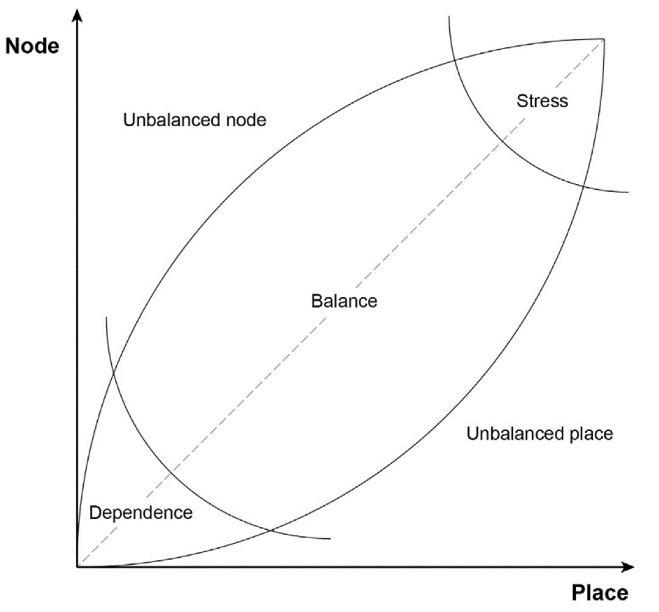
36]. Bertolini’s original model revolves around the dual axis of node and place indexes, which facilitate the identification of five ideal, typical situations—namely dependence, balance, pressure, unbalanced node, and unbalanced place—depicting potential distinctions among hubs (
Figure 1).
The NP model probes into the potential relationship between node function and place function, revealing that the two functions of a hub attain balance at specific value. In case of imbalance, balance can be achieved through two approaches: firstly, in unbalanced node state, by augmenting its place value or diminishing its node value; secondly, in an unbalanced place state, by enhancing connectivity to elevate its node value or adopting more locally orientated strategies.
In this model, the hub station areas are conceptualized as both the ‘node’ within the transportation network and ‘place’ within the city. This study accentuates two primary dimensions that can be evaluated when extending the original model of the station areas [
38,
39]: (i) the node index, relating to accessibility and connectivity of the station area with diverse transportation modes, and (ii) the place index, relating to quantity and diversity of potential activities within the station areas (such as their density and variety). Utilizing this model, it becomes feasible to pinpoint terminals that require an augmentation of their place dimension (classified as unbalanced nodes) and those that necessitate a bolstering of their node dimension (classified as unbalanced places).
Previous research has applied the model to various railway and subway stations, further exploring their relationships with the surrounding regions where the relevant hubs are situated [
40,
41]. While most applications of the model have focused on passenger terminals [
42,
43], fewer applications extended to cargo hubs and inland ports. Transportation terminals are commonly recognized as pivotal nodes for regional spatial, social, and economic activities, serving as the key drivers for national and regional development. Inland ports possess robust node functions that support port regionalization, facilitating the creation of transport network encompassing both global and local connections. The significance of their place functions is greatly augmented by factors such as cargo flow, information flow, and others. In this study, we have made certain adaptations to the original node-place model and implemented it on an urban scale, concentrating on China’s inland port system to assess the applicability of this model.
Transportation terminals like airports, ports, railway stations, and subway stations hold vital roles as nodes within transportation networks of varying scales. They are generally acknowledged as nuclei for regional spatial, social, and economic interactions. While seaports function as international transportation hubs, forming a global yet local link network enriched with robust node and location value, inland ports have exhibited comparable strong node value and industrial aggregation functions. They connect with seaports, contributing to the creation of transport networks spanning both global and local dimensions. The spatial extent and influence of this hub area are significantly amplified by factors such as cargo flow, information exchange, and others, which underscore their exceptional node and place functions.
This study aims to quantify the spatial impact of inland ports on regional development and evaluate their place and node functions. Utilizing the NP model, we measure the services provided by transport facilities (e.g., train service frequency) in the node dimension and assess the land use characteristics of an urban area (e.g., population density) in the place dimension, thereby reflecting the potential demand for transportation services. Furthermore, this paper examines the factors influencing the spatial value of the inland ports, identifies the specific situation types of each inland port, and discusses potential approaches to enhance the node value and place value, aiming to achieve a balanced situation of the two aspects. The evaluation of the spatial value of inland ports in this study, along with the associated influencing factors, is outlined in
Table 3.
3.2. Data Envelopment Analysis Model
Data envelopment analysis (DEA) stands as a well-established statistical technique that gauges relative efficiencies, especially in cases where straightforward efficiency is challenging to derive. This non-parametric method for assessing efficiency employs linear programming tools and was initially introduced by Charnes. It hinges on connecting technical efficiency with production frontiers [
44]. A notable advantage of DEA is its capability to handle multiple inputs and outputs. The units under assessment within the DEA model generally need to exhibit homogeneity and independence.
The fundamental DEA model, often referred to as DEA-CCR, is used to evaluate the efficiency of inland ports. The entities evaluated, known as decision-making units (DMUs), are typically characterized by several inputs utilized for the production of various outputs. If a DMU’s efficiency falls below 1, it is considered relatively inefficient. However, a DMU can only be described as relatively efficient rather than absolutely efficient. Numerous studies have adopted variations of the DEA model to assess seaport efficiency and performance. Tonzon [
45], for instance, compared the efficiency of several container ports, identifying potential for efficiency improvement by optimizing factors like the size and number of container berths, labor inputs, and total terminal area. Similarly, Cullinane and Wang [
46] assessed the relative efficiency of 69 European container terminals, concluding that larger terminals were more likely to exhibit higher efficiency. Based on previous research, Krmac and Mansouri [
47] conducted a systematic review, affirming DEA as a good assessment tool for scrutinizing port performance and proposing future applications.
Compared to seaports, the efficiency of inland ports has received little attention, and there is a scarcity of research on application of DEA in this context. Abdoulkarim et al. [
48] evaluated inland port competitiveness by analyzing the efficiencies of five inland ports in Africa. Haralambides and Gujar [
49] introduced a novel eco-DEA model to evaluate port service production, considering CO
2 emissions from container traffic originating from inland ports. However, these studies do not extensively explore inland ports’ effect on their area or region. Here, inland port efficiency is defined as the degree to which its node value contributes to its place value, and an evaluative indicator system is established. This paper employs the CCR model to assess the dynamic influence and effective contribution of inland ports to their region, utilizing the variables listed in
Table 4 for the DEA-CCR model of inland ports.
The CCR model addresses the limitations of the traditional efficiency calculation model of single input and single output by employing a multi-index system to assess relative efficiency. It is considered a comprehensive and well-suited approach for analyzing port production and performance evaluation. Initially, the inland port and its corresponding region are designated as decision-making units; each unit has
m input variables and
s output variables. These input and output variables can be represented as follows:
where
i = 1, 2, ...,
m;
j = 1, 2, ...,
n;
r = 1, 2, ...,
s;
n is the number of decision units;
Xij signifies the input variables of type
i for the
j decision unit; and
Ysj denotes the output variable of type
r for the
j decision unit. Then,
X is the (
i,
j) matrix of inputs, and
Y constitutes the (
r,
j) matrix of outputs. In the CCR model, the criterion for efficiency evaluation involves minimizing input while maintaining constant output. Inland port efficiency scores can be measured using the CCR model in envelopment form depicted by Equation (1):
where
j = 1, 2,
...,
n represents decision unit, and
X and
Y represent input and output variables, respectively.
is the optimal solution for decision unit
j;
X0 and
Y0 are the initial values of the input and output variables;
and
denote the input–output slack variables.
θ is the efficiency value, with
θ ≥ 1 indicating an efficient decision unit and 0 ≤
θ < 1 signifying the need for improvements to achieve optimal efficiency.
3.3. Data Collection
The study involves 12 inland ports of different development models, which are used to explore the spatial value, the interplay between node and place values, and, in particular, the efficiency of transportation nodes contributing to their place value in various regions. These 12 representative inland ports encompass a range of geographical disparities, spanning eastern, central, and western China (
Figure 2), thereby illustrating the diversity in their spatial value and efficiency across different inland port contexts. The particulars of these 12 inland ports in China are presented in
Table 5. Due to variations in their construction years, data input spans from 2016 to 2022. The foundational data were sourced from official websites, China Statistical Yearbooks, local government statistic yearbooks, and city-specific statistical bulletins.
Most of the inland ports fall under the category of long-distance, mid-range, or close-distance types. Each of them contributes to the expansion of logistical economies of scale through enhanced inland rail container shipping. In our categorization, inland ports are grouped into 3 distinct types: import distribution, export distribution, and import and export comprehensive. Each of these categories corresponds to a specific type of inland port classified according to their distance characteristics. As a result, the examples examined in this study are drawn from the 12 inland ports and their cities, each having connections with various seaports (as illustrated in
Table 6).
4. Results
4.1. Analysis of the NP Model
4.1.1. Correlation between the Two Natures of an Inland Port
This study analyzes the characteristics of the 12 inland ports, elucidating their function in the host cities based on the node-place model. It shows an intrinsic correlation between its characteristics as a node and a place, underscoring a noteworthy interplay between their development models and space value.
Table 7 offers insights into these correlations:
- (i)
Distinct Attributes: The dual natures of an inland port, both as a node and a place, manifest distinct attributes. The attributes of the 12 inland ports are outlined in
Table 7.
- (ii)
Interrelation of Attributes: The correlation between the attributes of the node and the place is evident. For example, in the case of Shijiazhuang Inland Port, its node attributes as a multimodal transportation hub are intrinsically linked to its place-based feature as a logistics growth pole in the mid and south regions of the province.
- (iii)
Impact of Development Model: There is a discernible relationship between an inland port’s development model and its space value. For example, under the seaport-based model, Yiwu Inland Port shows “traffic flow” attributes that integrate maritime, highway, and rail systems, thereby amplifying the inland port’s role as a cluster of international trade and procurement endeavors.
As a strategy for regional transportation planning, the site of an inland port is intricately intertwined with the broader logistics fabric of the city. The inland port becomes a focal point for economic and logistics activities, necessitating substantial land allocation within the urban landscape while simultaneously accommodating diverse spatial facilities. As the inland port upgrades its functional capacity, it concurrently strengthens the host city’s role in supporting the broader regional framework. Its place value that stems from its role as a node conversely underscores the impetus to enhance its node function, subsequently fostering concerted efforts toward improvement.
4.1.2. Evaluation of the Node Value with the Place Value
To facilitate comparison, the standardization method (Equation (2)) was used to normalize raw data within the [0, 1] range. Coupled with the entropy weighting method, this approach assigns weights to each indicator. Subsequently, evaluation levels for node value and place value corresponding to each inland port can be obtained.
where
and
denote the original and normalized data, respectively.
The outcomes are shown in
Figure 3 and
Table 8.
Figure 3 graphically illustrates the relative positioning of each inland port in terms of its node and place values, with emphasis on the most influential indices identified in
Table 3.
The analysis of
Figure 3 reveals the following observations:
- (i)
Half of the 12 inland ports exhibit a balanced situation, while approximately 25% are in an unbalanced place situation, and another 25% are in a dependency situation.
- (ii)
Balanced Inland Ports: This category includes all four of the city-based models and two of the seaport-based models (Yiwu and Shijiazhuang). These inland ports showcase a harmonious alignment between the node and the place values, a consequence of a well-orchestrated interplay between transportation and land use. For example, Lanzhou Inland Port has five international cargo railway lines that converge there, connecting to Europe, Central Asia, and South Asia, and the Land–Sea New Corridor in western China. This connectivity fosters robust trade for its agricultural resources and industry cluster in the city, thus contributing to a notable place value (0.75, as shown in
Table 8). A similar situation is observed in the case of Chengdu.
- (iii)
Dependent Inland Ports: All three inland ports adhering to the seaport and inland city cooperation model fall within this category. Dependent terminals exhibit a reliance on their host cities, indicating a low demand for transportation [
35]. Such a configuration is notably observed in the three inland ports of northeast China, where the node value remains considerably low and is not much helpful for stimulating its place value. Their efficacies are largely contingent upon their host cities which are provincial capital with large populations.
- (iv)
Unbalanced Place Inland Ports: Inland ports like Hefei, Ganzhou, and Kunming fall into this classification. In the NP model framework, this status denotes a scenario where the node value significantly outweighs the place value [
34]. For example, Kunming Inland Port has created a robust node value, mainly driven by its facilitation of the Sea–Land New Corridor in western China and its connectivity with the Association of Southeast Asian Nations (ASEAN). However, the corresponding place value remains comparatively modest.
A deeper understanding of the correlation between its values in the transportation network (node) and the value attributed to its surrounding region (place) is attained by closely comparing the balanced with the dependent scenarios. Balanced inland ports tend to exhibit high-density land use and superior node accessibility [
34], exemplified by Xi’an Inland Port’s distinction of hosting the highest annual number of Chinese–European trains. On the contrary, dependent inland ports are characterized by smaller nodes that rely heavily on the host city for cargo flow [
35]. A possible solution involves the integration of land use planning near the node [
39], fostering a synergistic alignment of transportation network and activity accumulation.
4.2. Analysis of the DEA Model
The above discussion about the 12 cases of various inland ports has underscored the disparities in node value, as well as the varying capacities of their node function, which contribute to place value. While it is a prominent trend in developing countries to utilize inland ports as a tool for regional development [
28,
33], a gap in the existing literature about the NP model lies in the evaluation of the efficiency of the node value’s contribution to place value. In this section, the technical efficiency of these 12 inland ports is compared and assessed using Equation (1) and
Table 4 via the DEAP 2.1 software.
The evaluation result of the efficiency of the 12 inland ports is presented in
Table 9. Out of the 12 decision-making units (DMUs), seven are considered to be efficient. These include the inland ports of Xi’an, Yiwu, Lanzhou, Chengdu, Ganzhou, Changchun, and Kunming. This implies that over 50% of the inland ports are operating efficiently and substantively, contributing to regional economic growth. Remarkably, most of these seven efficient inland ports align with the balance situation within the NP model. For instance, Yiwu Inland Port is strategically positioned within the Yiwu–Ningbo–Zhoushan transport corridor, connected to the hinterland through an integrated rail and road network with Ningbo–Zhoushan Port, enabling it to significantly impact the surrounding area.
Conversely, the remaining five inland ports in
Table 9 exhibit efficiency scores below 1.0. These five are deemed to be operating inefficiently and are not optimally supporting the regional economy. Their comparatively lower efficiency could be partially attributed to the lack of inadequate collaboration with seaports and suboptimal integration with the transport system of their host cities. While seaports vie for collaboration with inland ports, the latter stand to gain from upgraded facilities and improved efficiency. The lower efficiency scores indicate the suboptimal alignment of input and output factors in
Table 4, alongside inadequate support and coordination with their node function within the host cities. For instance, Harbin Inland Port exhibits low efficiency, stemming from insufficient investment and limited collaboration, despite its association with a seaport.
In
Table 9, the collective average efficiency score derived from the CCR model is 0.786. It indicates a relatively high level of efficiency among the inland ports. Those inland ports achieving perfect efficiency scores of 1.0 owe their success to key factors, such as extensive operational areas and high throughput volumes, coupled with effective resource management, strong transport connectivity, and well-developed infrastructure. On the other hand, the less efficient inland ports can attribute their inefficiency to similar factors within their urban logistics systems. This analysis emphasizes the potential path for improving the efficiency of inland ports.
5. Discussion
Inland ports are gaining recognition not only as transport nodes but also as pivotal components of the socio-economic landscape. In China, local governments increasingly emphasize their place value and consider them as nodes within logistics supply chains and catalysts for regional development and urban expansion. This study delves into the influence of inland port activities on regional development, focusing on the selection of 12 inland ports across various regions of China. The node–place (NP) model and data envelopment analysis (DEA) model are employed to explore the spatial value and efficiency. The ensuing discussion draws several key insights:
- (1)
Balancing Node and Place Values: Inland ports encompass two intertwined dimensions—the node value as transportation hubs and the place value within the urban fabric. These dual functions have competing goals, and striking a balance between them is a complex endeavor. While inland ports may prioritize their node value to enhance transportation capabilities, competition for land and other urban activities can pose challenges. This conflict necessitates strategies to align inland port development with urban planning objectives.
- (2)
Sufficient Land Allocation for Future Expansion: With the conceptual framework of the node and place values of an inland port and the interplay between the two values, it is imperative to contemplate how an inland port of diverse development type can attain a more balanced equilibrium of the two values. In the context of Chinese inland ports, due to their significant role in regional logistics and the distribution of urban goods, they usually are located within densely populated areas in urban centers. Given the scarcity of available land, it is important to assess whether the host city can consistently provide land for its future expansion or sustain its logistic operations, especially when faced with heightened land demands from various stakeholders. Besides favorable tax policies, ensuring a secure land allocation is a pivotal guarantee for its development. Even at the beginning of its development, it is essential to allocate a certain amount of land to ensure its core operational activities, with the added benefit of favorable tax policies to attract investors and service providers.
- (3)
Stakeholder Dynamics: Inland ports are subject to diverse stakeholders, ranging from national governments prioritizing node value to local governments focusing on place value, the input of local lands, and economic benefit or social welfare for the local community.
Because their functions and effects differ from those of metro and railway stations, inland ports require more extensive land and exert a greater economic impact on the urban region and even broader areas. A noticeable trend is emerging wherein the role and function of inland ports in regional development are garnering increased attention. Moreover, the spatial value of inland ports varies across geographical spaces and scales. For instance, the host city, the provincial governments, and the central government may each have distinct concerns and interests regarding the inland port.
- (4)
Cooperation for Spatial Value Coordination: Effectively coordinating the simultaneous development of the inland port, both as a node and place, is of paramount importance for a hub area and has an impact on the spatial structure. For example, when a seaport company invests in an inland port, its primary focuses tend to be on maximizing its node value, thus optimizing its efficiency of bringing cargo to the seaport quickly and efficiently. Conversely, local governments are primarily concerned with their efficiency in promoting and fostering regional growth.
Considering these varying interests and the growing focus on using the inland port to catalyze local development, it may inspire further discussion involving multiple stakeholders. This could lead to the exploration of policy innovation aimed at improving spatial value efficiency. Furthermore, it is imperative to consider the impact on the social network of the stakeholders in order to facilitate regional and local business. This may possibly result in co-investment and a more effective governance structure, aligning objectives with national strategies. Striving for a harmonious equilibrium between the node value and place value of inland ports becomes crucial in this context.
- (5)
Cooperation for Spillover Effects: Positive spillover effects that surpass direct effects offer a rationale for collaboration among neighboring cities in terms of investment and management. Adhering to the beneficiary pay principle, adjacent cities shall be engaged for co-investment or mutual equity participation in inland port development. This approach is justified by the fact that beneficiary cities may have to collectively bear the expenses associated with the establishment and operation of the transportation facilities. Leveraging inland ports as economic hubs that link coastal ports and extend their influence to the surrounding region can change the traditional pattern of trade and logistics route orientation that predominantly targets the movement between coastal to inland areas.
6. Conclusions
Inland ports not only function as a location node but also encompass the spatial dimension of socio-economic phenomena. They are generally recognized as transportation hubs and nodes, and more recently, they have been acknowledged as integral components of the logistics supply chain system. Furthermore, they play a pivotal role within the regional system. This study examines the impact of inland port activities on regional development, focusing on a sample of 12 inland ports situated in China’s eastern, central, and western regions. The node-place model and DEA model are used to explore the spatial value and efficiency of these inland ports. This study yields the following conclusions: (1) The inland ports are intricately interconnected with the city’s logistics network and are an important facilitator for regional transportation planning. (2) Among the 12 studied inland ports, half exhibit a balanced relationship between their node and place values. (3) Over 50% of inland ports demonstrate efficiency, contributing positively to regional economic growth during the phases of robust expansion. Notably, the most efficient inland ports tend to maintain a balanced interplay between their node and place values.
The findings advocate for collaboration strategies, wherein inland ports and urban regions cooperate to maximize benefits. Due to the multifaceted functions of inland ports, their impact on regional development has become increasingly prominent. Inland ports contribute to the regionalization of the hinterlands, reducing distribution costs and enhancing transportation efficiency, thereby expanding their spatial value. The establishment of multimodal transport networks will attract investment to inland ports and urban areas. As the inland ports continue to grow and develop, their association with urban locales intensifies, consequently fostering the expansion and proliferation of urban places.
Several aspects need further consideration. It would be interesting to extend the study by utilizing the established model and its applications. The present study, while insightful, is subject to certain limitations, focusing primarily on specific inland port modes and samples, with a primary concern on the node and place values. Future research endeavors may use a multi-dimensional mixed approach, potentially yielding deeper insights into inland ports. Furthermore, incorporating additional efficiency measures and integrating them with diverse DEA methods could prove beneficial. Future research avenues include further exploration of the proposed model’s capabilities and applications, considering additional inland port modes, and extending the temporal and spatial scope. These endeavors can contribute to a more comprehensive understanding of the multifaceted impacts and potential of inland ports on regional development.
Author Contributions
Conceptualization, P.Z. and X.L.; writing—original draft preparation, X.L.; data collection and data curation, X.L. and J.W.; methodology: X.L. and J.W.; formal analysis, X.L.; visualization: X.L.; funding acquisition, project administration, supervision, result analysis, and validation, P.Z.; investigation, X.L. and J.W.; writing—second and final draft, translation, and review and editing, P.Z. All authors have read and agreed to the published version of the manuscript.
Funding
This research was funded by the National Social Science Fund of China (No. 19BJL041).
Institutional Review Board Statement
Not applicable.
Informed Consent Statement
Not applicable.
Data Availability Statement
Not applicable.
Acknowledgments
We would like to extend our gratitude for the support provided by the National Social Science Found of China towards the publication.
Conflicts of Interest
The authors declare no conflict of interest.
References
- Khaslavskaya, A.; Roso, V. Dry ports: Research outcomes, trends, and future implications. Marit. Econ. Logist. 2020, 22, 265–292. [Google Scholar] [CrossRef]
- Miraj, P.; Berawi, M.A.; Zagloel, T.Y.; Sari, M.; Saroji, G. Research trend of dry port studies: A two-decade systematic review. Marit. Policy Manag. 2020, 48, 563–582. [Google Scholar] [CrossRef]
- Roso, V.; Lumsden, K. A review of dry ports. Marit. Econ. Logist. 2010, 12, 196–213. [Google Scholar] [CrossRef]
- Witte, P.; Wiegmans, B.; Ng, A.K. A critical review on the evolution and development of inland port research. J. Transp. Geogr. 2019, 74, 53–61. [Google Scholar] [CrossRef]
- Zhao, D.; Li, Z.; Zhou, Y.; Xiao, C.; Liang, S.-S. Measurement and spatial spillover effects of port comprehensive strength: Empirical evidence from China. Transp. Policy 2020, 99, 288–298. [Google Scholar] [CrossRef]
- Sakalayen, Q.; Chen, P.S.-L.; Cahoon, S. A place-based approach for ports’ involvement in regional development: A mixed-method research outcome. Transp. Policy 2022, 119, 16–31. [Google Scholar] [CrossRef]
- Hilling, D.; Hoyle, B.S. Seaport Systems and Spatial Change: Technology, Industry, and Development Strategies; Wiley: Chichester, UK, 1984; pp. 83–96. [Google Scholar]
- Guo, J.; Qin, Y.; Du, X.; Han, Z. Dynamic measurements and mechanisms of coastal port–city relationships based on the DCI model: Empirical evidence from China. Cities 2020, 96, 102440. [Google Scholar] [CrossRef]
- Somu, R.; Jeevan, J.; Mohd Salleh, N.H.; Othman, M.R.; Mokhtar, K.; Ngah, A.H. The role of seaports in regional development in the East Coast of Peninsular Malaysia: An evaluation through an exploratory factor analysis. J. Supply Chain Manag. 2022, 16, 617. [Google Scholar] [CrossRef]
- Beresford, A.; Pettit, S.; Xu, Q.; Williams, S. A study of dry port development in China. Marit. Econ. Logist. 2012, 14, 73–98. [Google Scholar] [CrossRef]
- Nguyen, L.C.; Notteboom, T. The relations between dry port characteristics and regional port-hinterland settings: Findings for a global sample of dry ports. Marit. Policy Manag. 2018, 46, 24–42. [Google Scholar] [CrossRef]
- Ng, A.K.Y.; Cetin, I.B. Locational Characteristics of Dry Ports in Developing Economies: Some Lessons from Northern India. Reg. Stud. 2012, 46, 757–773. [Google Scholar] [CrossRef]
- Talley, W.K.; Ng, M. Hinterland transport chains: A behavioral examination approach. Transp. Res. Part E Logist. Transp. Rev. 2018, 113, 94–98. [Google Scholar] [CrossRef]
- Ng, A.Y.; Gujar, G.C. Government policies, efficiency and competitiveness: The case of dry ports in India. Transp. Policy 2009, 16, 232–239. [Google Scholar] [CrossRef]
- Khaslavskaya, A.; Roso, V. Outcome-driven supply chain perspectives on dry ports. Sustainability 2019, 11, 1492. [Google Scholar] [CrossRef]
- Ng, A.K.; Ducruet, C.; Jacobs, W.; Monios, J.; Notteboom, T.; Rodrigue, J.-P.; Slack, B.; Tam, K.-C.; Wilmsmeier, G. Port geography at the crossroads with human geography: Between flows and spaces. J. Transp. Geogr. 2014, 41, 84–96. [Google Scholar] [CrossRef]
- Lam, N.C. Defining dry port characteristics: Insights from a global sample. J. Marit. Sci. Technol. 2018, 77, 78–93. [Google Scholar]
- Lamii, N.; Bentaleb, F.; Fri, M.; Douaioui, K.; Mabrouki, C.; Semma, E.A. Systematic review of literature on dry port concept evolution. Trans. Marit. Sci. 2020, 9, 248–270. [Google Scholar] [CrossRef]
- Rozic, T.; Rogic, K.; Bajor, I. Research trends of inland terminals: A literature review. Promet-Traffic Transp. 2016, 28, 539–548. [Google Scholar] [CrossRef]
- Notteboom, T.E.; Rodrigue, J.-P. Port regionalization: Towards a new phase in port development. Marit. Policy Manag. 2005, 32, 297–313. [Google Scholar] [CrossRef]
- Behdani, B.; Wiegmans, B.; Roso, V.; Haralambides, H. Port-hinterland transport and logistics: Emerging trends and frontier research. Marit. Econ. Logist. 2020, 22, 1–25. [Google Scholar] [CrossRef]
- Monios, J.; Wilmsmeier, G. Giving a direction to port regionalisation. Transp. Res. Part A Policy Pract. 2012, 46, 1551–1561. [Google Scholar] [CrossRef]
- Zheng, S.; Zhang, Q.; van Blokland, W.B.; Negenborn, R.R. The development modes of inland ports: Theoretical models and the Chinese cases. Marit. Policy Manag. 2020, 48, 583–605. [Google Scholar] [CrossRef]
- Wilmsmeier, G.; Monios, J.; Rodrigue, J.-P. Drivers for Outside-In port hinterland integration in Latin America: The case of Veracruz, Mexico. Res. Transp. Bus. Manag. 2015, 14, 34–43. [Google Scholar] [CrossRef]
- Witte, P.; Wiegmans, B.; Roso, V.; Hall, P.V. Moving beyond land and water: Understanding the development and spatial organization of inland ports. J. Transp. Geogr. 2020, 84, 102676. [Google Scholar] [CrossRef]
- Monios, J.; Wang, Y. Spatial and institutional characteristics of inland port development in China. GeoJournal 2013, 78, 897–913. [Google Scholar] [CrossRef]
- Ng, A.K.; Tongzon, J.L. The transportation sector of India’s economy: Dry ports as catalysts for regional development. Eurasian Geogr. Econ. 2010, 51, 669–682. [Google Scholar] [CrossRef]
- Montwiłł, A.; Pietrzak, O.; Pietrzak, K. The role of Integrated Logistics Centers (ILCs) in modelling the flows of goods in urban areas based on the example of Italy. Sustain. Cities Soc. 2021, 69, 102851. [Google Scholar] [CrossRef]
- Wiegmans, B.; Witte, P.; Spit, T. Characteristics of European inland ports: A statistical analysis of inland waterway port development in Dutch municipalities. Transp. Res. Part A Policy Pract. 2015, 78, 566–577. [Google Scholar] [CrossRef]
- Flämig, H.; Hesse, M. Placing dryports. Port regionalization as a planning challenge–The case of Hamburg, Germany, and the Süderelbe. Res. Transp. Econ. 2011, 33, 42–50. [Google Scholar] [CrossRef]
- Raimbault, N. From regional planning to port regionalization and urban logistics. The inland port and the governance of logistics development in the Paris region. J. Transp. Geogr. 2019, 78, 205–213. [Google Scholar] [CrossRef]
- Lovrić, I.; Bartulović, D.; Steiner, S. Influence of Dry Port Establishment on Regional Development Through Regional Development Index. Trans. Marit. Sci. 2020, 9, 293–315. [Google Scholar] [CrossRef]
- Song, Y.; Liu, H. Internet development, economic level, and port total factor productivity: An empirical study of Yangtze River ports. Int. J. Logist. Res. Appl. 2020, 23, 375–389. [Google Scholar] [CrossRef]
- Bertolini, L. Nodes and places: Complexities of railway station redevelopment. Eur. Plan. Stud. 1996, 4, 331–345. [Google Scholar] [CrossRef]
- Bertolini, L. Station area redevelopment in five European countries: An international perspective on a complex planning challenge. Int. Plan Stud. 1998, 3, 163–184. [Google Scholar] [CrossRef]
- Liao, C.; Scheuer, B. Evaluating the performance of transit-oriented development in Beijing metro station areas: Integrating morphology and demand into the node-place model. J. Transp. Geogr. 2022, 100, 103333. [Google Scholar] [CrossRef]
- Bertolini, L. Spatial development patterns and public transport: The application of an analytical model in the Netherlands. Plan. Pract. Res. 1999, 14, 199–210. [Google Scholar] [CrossRef]
- Vale, D.S.; Viana, C.M.; Pereira, M. The extended node-place model at the local scale: Evaluating the integration of land use and transport for Lisbon’s subway network. J. Transp. Geogr. 2018, 69, 282–293. [Google Scholar] [CrossRef]
- Hynynen, A.J.N. Node-Place-Model; A Strategic Tool for Regional Land Use Planning. Nordisk Arkitekturforskning 2013, 18, 3–4. [Google Scholar]
- Kim, J.-S.; Shin, N. Planning for Railway Station Network Sustainability Based on Node–Place Analysis of Local Stations. Sustainability 2021, 13, 4778. [Google Scholar] [CrossRef]
- Peek, G.-J.; Bertolini, L.; De Jonge, H. Gaining insight in the development potential of station areas: A decade of node-place modelling in The Netherlands. Plann. Pract. Res. 2006, 21, 443–462. [Google Scholar] [CrossRef]
- Gui, W.; Zhang, X.; Wang, A. Research on spatial planning evaluation of Beijing Shanghai high speed railway station based on node-place model. J. Intell. Fuzzy Syst. 2021, 40, 733–743. [Google Scholar] [CrossRef]
- Olaru, D.; Moncrieff, S.; McCarney, G.; Sun, Y.; Reed, T.; Pattison, C.; Smith, B.; Biermann, S. Place vs. Node Transit: Planning Policies Revisited. Sustainability 2019, 11, 477. [Google Scholar] [CrossRef]
- Charnes, A.; Cooper, W.; Lewin, A.Y.; Seiford, L.M. Data envelopment analysis theory, methodology and applications. J. Oper. Res. Soc. 1997, 48, 332–333. [Google Scholar] [CrossRef]
- Tongzon, J. Efficiency measurement of selected Australian and other international ports using data envelopment analysis. Transp. Res. Part A Policy Pract. 2001, 35, 107–122. [Google Scholar] [CrossRef]
- Cullinane, K.P.; Wang, T.-F. The efficiency of European container ports: A cross-sectional data envelopment analysis. Int. J. Logist. Res. Appl. 2006, 9, 19–31. [Google Scholar] [CrossRef]
- Krmac, E.; Mansouri Kaleibar, M. A comprehensive review of data envelopment analysis (DEA) methodology in port efficiency evaluation. Marit. Econ. Logist. 2022, 24, 1–65. [Google Scholar] [CrossRef]
- Abdoulkarim, H.T.; Fatouma, S.H.; Hassane, H.T. Assessment of dry Port efficiency in Africa using data envelopment analysis. J. Transp. Technol. 2019, 9, 193–203. [Google Scholar] [CrossRef][Green Version]
- Haralambides, H.; Gujar, G. On balancing supply chain efficiency and environmental impacts: An eco-DEA model applied to the dry port sector of India. Marit. Econ. Logist. 2012, 14, 122–137. [Google Scholar] [CrossRef]
| Disclaimer/Publisher’s Note: The statements, opinions and data contained in all publications are solely those of the individual author(s) and contributor(s) and not of MDPI and/or the editor(s). MDPI and/or the editor(s) disclaim responsibility for any injury to people or property resulting from any ideas, methods, instructions or products referred to in the content. |
© 2023 by the authors. Licensee MDPI, Basel, Switzerland. This article is an open access article distributed under the terms and conditions of the Creative Commons Attribution (CC BY) license (https://creativecommons.org/licenses/by/4.0/).


