
Framework for the Design of a Small Transport Hub as an Interdisciplinary Challenge to Implement Sustainable Solutions

 ,
,  , , ,
, , ,
Abstract
1. Introduction
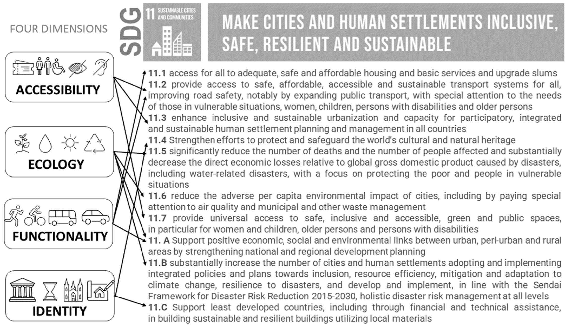
1.1. Sustainable Development Goals in the Literature
1.2. Sustainability Solutions in Small Transport Hub Design
1.3. Objective of the Study

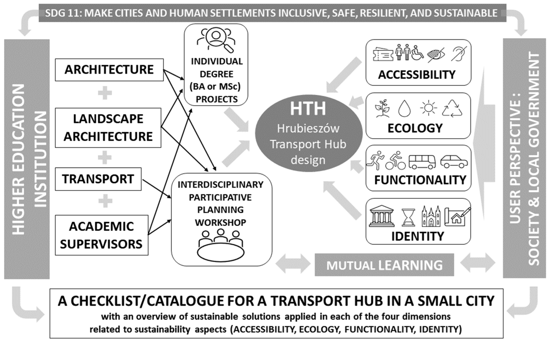
2. Materials and Methods
2.1. Methodology
- Master’s degree in either Architecture and Urban Design, Landscape Architecture, or Transport,
- A Ph.D. degree,
- Participation in sustainability-focused research projects.
2.2. Case Presentation
- Workshop-based consultations with students from two of Hrubieszów’s high schools. The high-school students expressed their opinions of the current state of the transport hub site and their wishes and expectations concerning the area and its potential future redevelopment;
- Public consultations with local stakeholder groups: persons with special needs and representatives of local passenger transport companies who operated bus lines that made use of the transport hub;
- A design workshop section, during which students prepared their projects under the supervision of expert tutors;
- A final presentation, during which a summary of the consultations and the projects were shown to the public in Hrubieszów and feedback was collected from stakeholders.
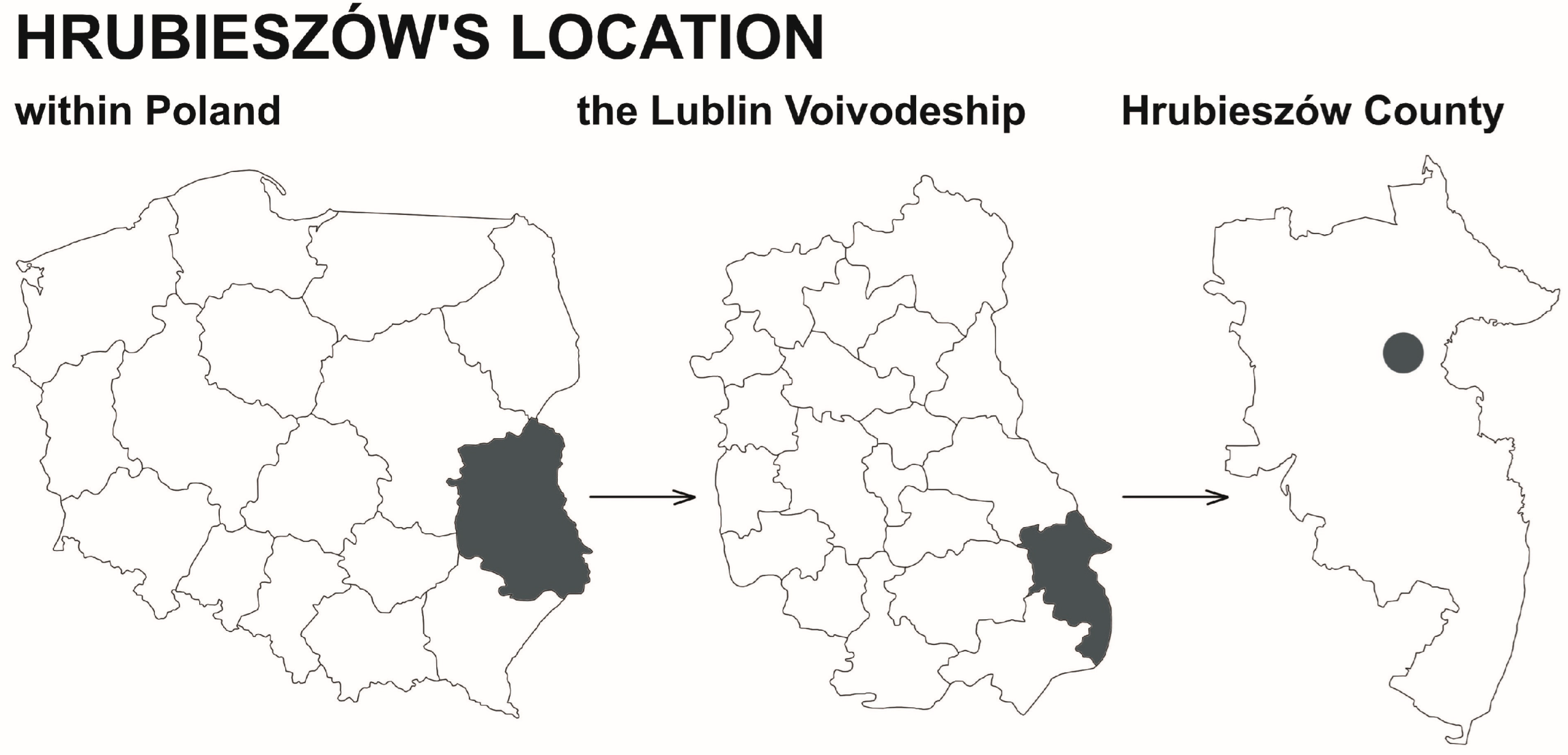
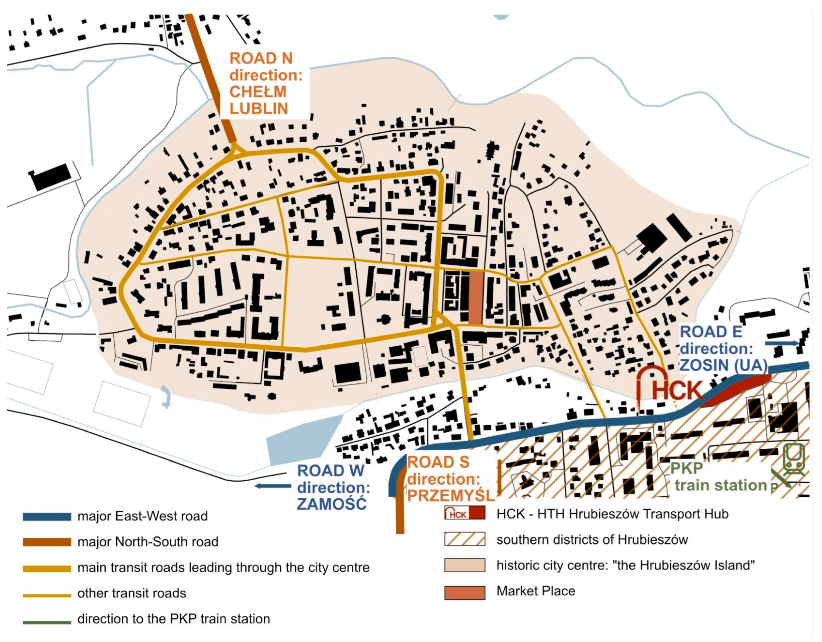
2.2.1. The City of Hrubieszów—Local Context
2.2.2. Accessibility
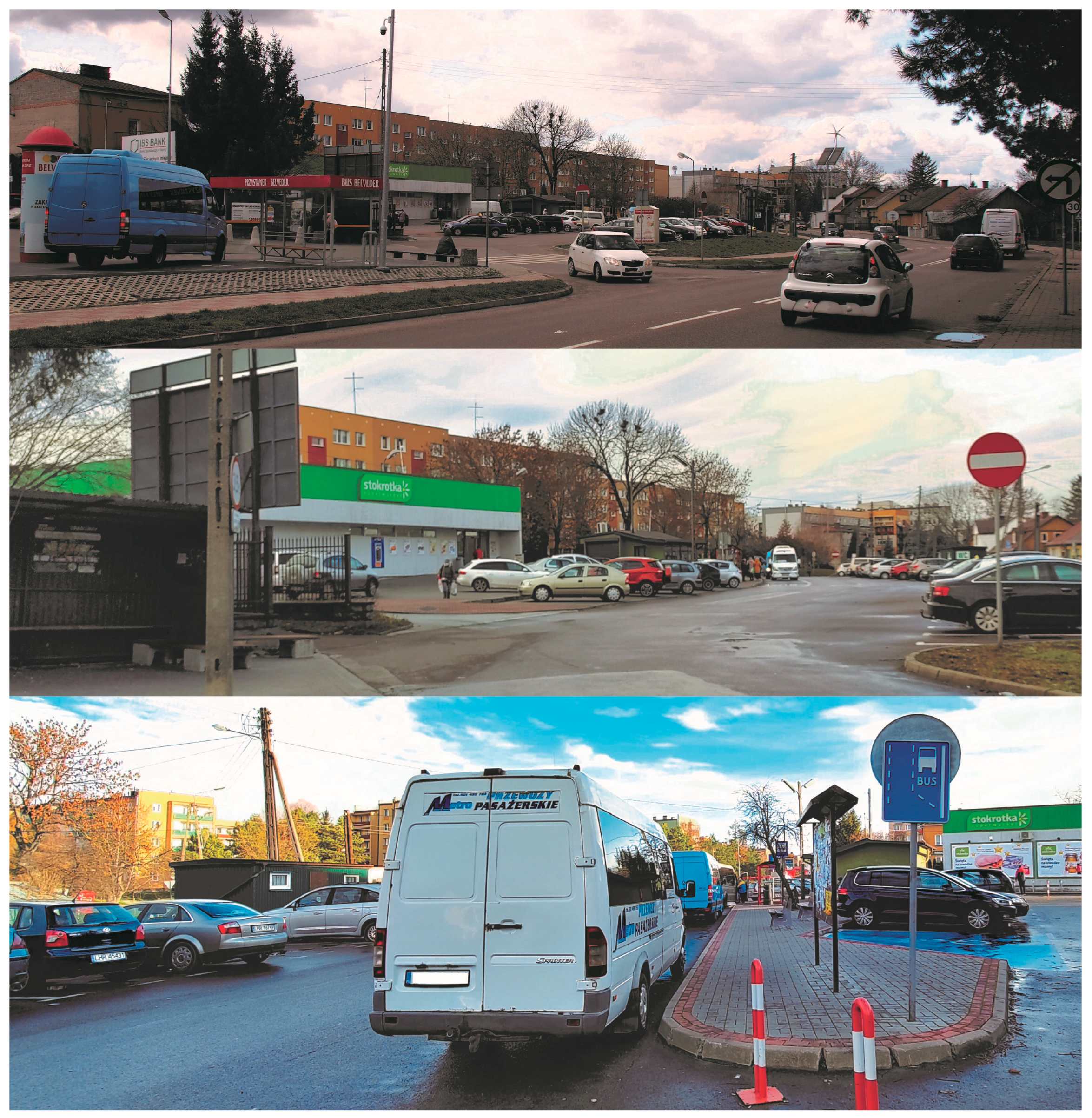
2.2.3. Project Site
- Minimum share of biologically active surfaces—20%;
- Maximum share of land occupied by building footprints—40%;
- Development density—0.1–1.5;
- Maximum development height—11 m.
2.3. Sustainability-Focused Solutions
2.3.1. Accessibility
2.3.2. Ecology
2.3.3. Functionality
2.3.4. Identity
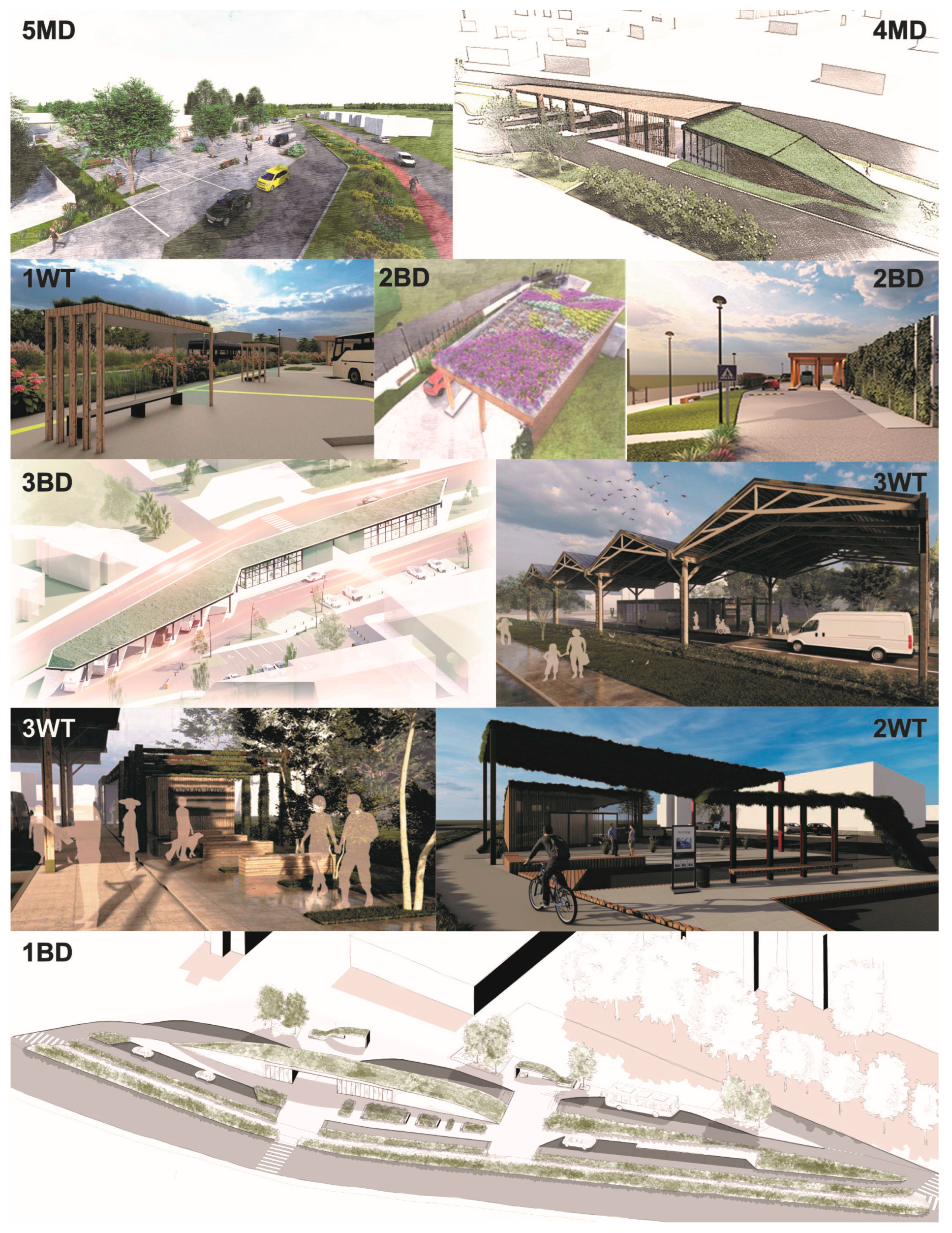
3. Results
Presentation of Results


| Students’ Designs of HTH | Application of Sustainable Solutions in II Dimension—ECOLOGY | ||||||||||||||
|---|---|---|---|---|---|---|---|---|---|---|---|---|---|---|---|
| project type | degree of studies 1B/2M curriculum A/LA/T | RG | RT | BAI | GR | GW | GS | TG | MG | LV | CP | SF | RW | number of sustainable solutions depending on the project type | |
| BD—bachelor diploma design/MD—master diploma design | out of 9 | ||||||||||||||
| 1BD | 1B/LA | ✓ | ✓ | ✓ | ✓ | ✓ | ✓ | ✓ | ✓ | 8 | |||||
| 2BD | 1B/LA | ✓ | ✓ | ✓ | ✓ | ✓ | ✓ | ✓ | ✓ | 8 | |||||
| 3BD | 1B/A | ✓ | ✓ | ✓ | ✓ | ✓ | ✓ | 7 | |||||||
| 4MD | 2M/LA | ✓ | ✓ | ✓ | ✓ | ✓ | ✓ | ✓ | ✓ | ✓ | 9 | ||||
| 5MD | 2M/LA | ✓ | ✓ | ✓ | ✓ | ✓ | ✓ | ✓ | ✓ | ✓ | ✓ | 10 | |||
| 6MD | 2M/A | ✓ | ✓ | ✓ | ✓ | ✓ | ✓ | ✓ | ✓ | ✓ | ✓ | 10 | |||
| WD—workshop designs | |||||||||||||||
| 1WD | 1B/2M A/LA/T | ✓ | ✓ | ✓ | ✓ | ✓ | ✓ | ✓ | ✓ | 8 | |||||
| 2WD | ✓ | ✓ | ✓ | ✓ | ✓ | ✓ | ✓ | ✓ | ✓ | ✓ | 10 | ||||
| 3WD | ✓ | ✓ | ✓ | ✓ | ✓ | ✓ | ✓ | ✓ | 8 | ||||||

| Students’ Designs of HTH | Application of Sustainable Solutions in III Dimension—FUNCTIONALITY | ||||||||||||||
|---|---|---|---|---|---|---|---|---|---|---|---|---|---|---|---|
| project type | degree of studies 1B/2M curriculum A/LA/T | PP | RC | BP | SV | RP | TM | WC | SB | PC | CS | WF | LG | number of sustainable solutions depending on the project type | |
| BD—bachelor diploma design/MD—master diploma design | out of 9 | ||||||||||||||
| 1BD | 1B/LA | ✓ | ✓ | ✓ | ✓ | ✓ | ✓ | ✓ | ✓ | 8 | |||||
| 2BD | 1B/LA | ✓ | ✓ | ✓ | ✓ | ✓ | ✓ | ✓ | 7 | ||||||
| 3BD | 1B/A | ✓ | ✓ | ✓ | ✓ | ✓ | ✓ | ✓ | ✓ | 8 | |||||
| 4MD | 2M/LA | ✓ | ✓ | ✓ | ✓ | ✓ | ✓ | ✓ | ✓ | ✓ | ✓ | 10 | |||
| 5MD | 2M/LA | ✓ | ✓ | ✓ | ✓ | ✓ | ✓ | ✓ | 7 | ||||||
| 6MD | 2M/A | ✓ | ✓ | ✓ | ✓ | ✓ | ✓ | ✓ | ✓ | ✓ | 9 | ||||
| WD—workshop designs | |||||||||||||||
| 1WD | 1B/2M A/LA/T | ✓ | ✓ | ✓ | ✓ | ✓ | ✓ | ✓ | ✓ | 8 | |||||
| 2WD | ✓ | ✓ | ✓ | ✓ | ✓ | ✓ | ✓ | ✓ | ✓ | ✓ | 10 | ||||
| 3WD | ✓ | ✓ | ✓ | ✓ | ✓ | ✓ | ✓ | ✓ | ✓ | ✓ | ✓ | 11 | |||
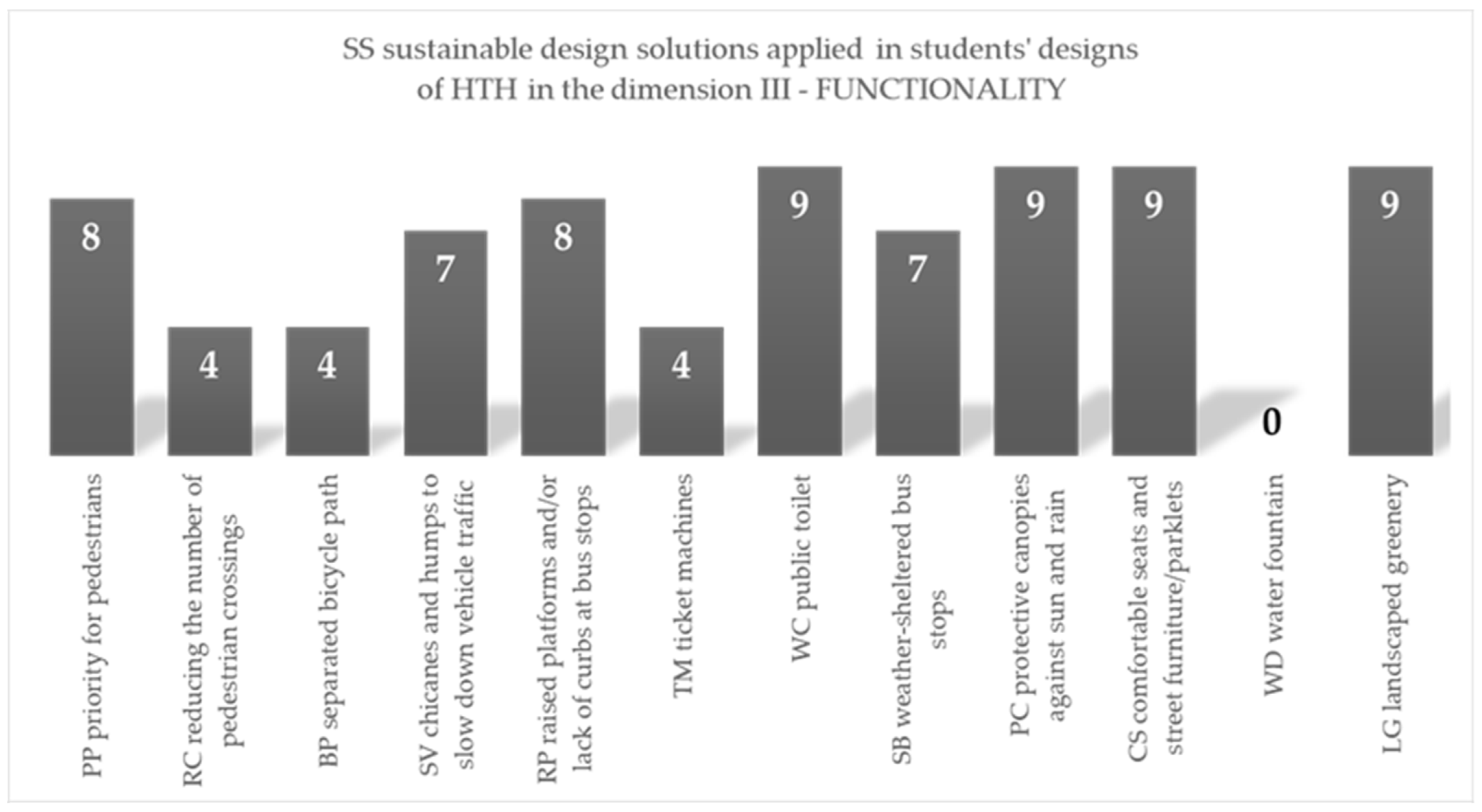
| summary of results —number of applied sustainable solutions | 8 | 4 | 4 | 7 | 8 | 4 | 9 | 7 | 9 | 9 | 0 | 9 | |||
| out of 12 | |||||||||||||||

| Students’ Designs of HTH | Application of Sustainable Solutions in III Dimension—FUNCTIONALITY | ||||||||||||||
|---|---|---|---|---|---|---|---|---|---|---|---|---|---|---|---|
| project type | degree of studies 1B/2M curriculum A/LA/T | CC | CF | CI | GT | CG | MC | WA | LM | CW | RB | VK | NV | number of sustainable solutions depending on the project type | |
| BD—bachelor diploma design/MD—master diploma design | out of 9 | ||||||||||||||
| 1BD | 1B/LA | ✓ | ✓ | ✓ | 3 | ||||||||||
| 2BD | 1B/LA | ✓ | ✓ | ✓ | 3 | ||||||||||
| 3BD | 1B/A | ✓ | ✓ | ✓ | 3 | ||||||||||
| 4MD | 2M/LA | ✓ | ✓ | ✓ | ✓ | ✓ | ✓ | ✓ | 7 | ||||||
| 5MD | 2M/LA | ✓ | ✓ | ✓ | ✓ | ✓ | ✓ | ✓ | ✓ | 8 | |||||
| 6MD | 2M/A | ✓ | ✓ | ✓ | ✓ | ✓ | ✓ | 6 | |||||||
| WD—workshop designs | |||||||||||||||
| 1WT | 1B/2M A/LA/T | ✓ | ✓ | ✓ | ✓ | ✓ | ✓ | ✓ | ✓ | ✓ | 9 | ||||
| 2WT | ✓ | ✓ | ✓ | ✓ | ✓ | ✓ | 6 | ||||||||
| 3WT | ✓ | ✓ | ✓ | ✓ | ✓ | ✓ | ✓ | ✓ | ✓ | ✓ | 10 | ||||
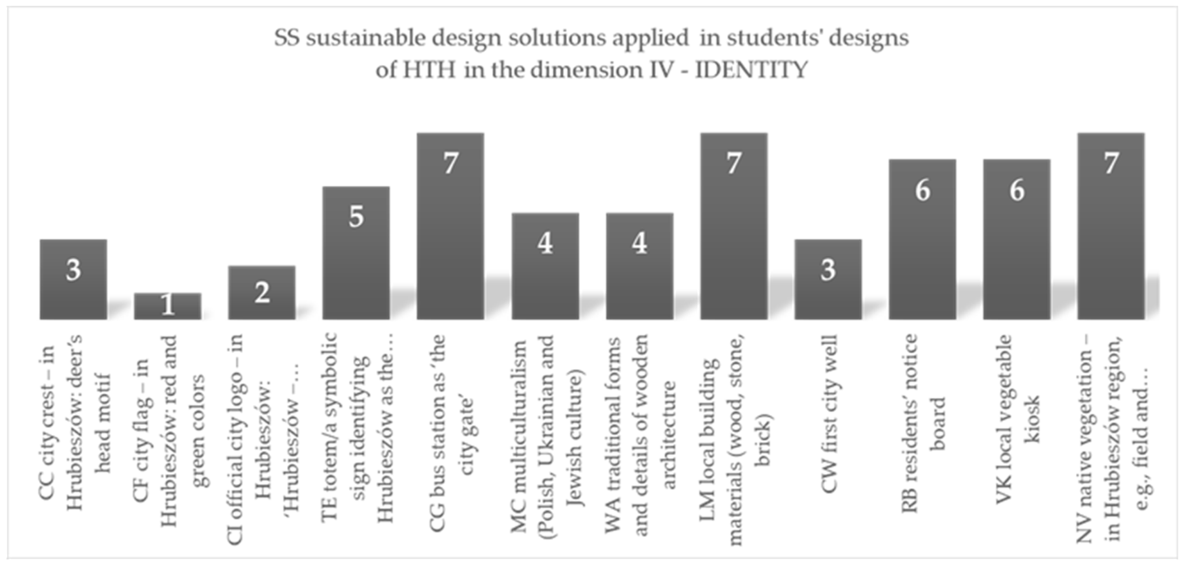
| summary of results —number of applied sustainable solutions | 3 | 1 | 2 | 5 | 7 | 4 | 4 | 7 | 3 | 6 | 6 | 7 | |||
| out of 12 | |||||||||||||||

- The lowest number of applications was observed in first cycle (bachelor’s) thesis projects, prepared at the very start of the HTH development project, when the knowledge of students and tutors/supervisors concerning site-specific conditions was incomplete, namely based only on one site inspection, or was not preceded by such an inspection;
- A greater number of applications was observed in the projects prepared as part of the participation workshop held in May 2022 in Hrubieszów, during which students worked in interdisciplinary groups under the supervision of tutors who represented three design specializations (architecture, landscape architecture, transport), and participated in site inspections and consultations with representatives of persons with disabilities and special needs and with representatives of municipal services;
- The greatest number of instances of sustainable design solution application was observed in second cycle (master’s) thesis designs, whose authors had participated in the workshop;
- A notably greater number of application instances was observed for projects whose co-authors included landscape architecture students. In addition, it was noted that the LA program curriculum featured sustainable design solutions in a greater number of instances than the curricula for the other two programs.
- Most of the sustainable solutions applied by students referred to features often required in contemporary design, such as green technologies, ergonomic efficiency, proper space arrangement, public transport priority, cycling, and e-mobility. The novelty of the approach lies in solutions applied only to a limited extent, such as the careful choice of planting material adjusted to local environment specifics (only native plants), arrangement of space for non-neurotypical users, and varied interpretations of cultural identity.
4. Discussion
4.1. Possible Influence Factors
| Factors That May Have Contributed to SS Application Rates in HTH Design Proposals | |||||
|---|---|---|---|---|---|
| 1 | SS featured in Architecture, Landscape Architecture, or Transport program curricula | ||||
| Architecture | Landscape architecture | Transport | |||
| 2 | Site- and project-specific factors | ||||
| Mandatory element, featured in the HTH use program | |||||
| Biological area index specified | |||||
| Discussed during tutor presentations in the workshop | |||||
| Discussed during consultations with PwDs | |||||
| Discussed during consultations with transport operators | |||||
| Local problem visible/explained during site visit | |||||
| Factors that may have negatively contributed to SS application | |||||
| 3 | Excessive generality (multidimensionality) or level of detail (complicatedness) or a given solution requiring disproportionate attention relative to design task duration | ||||
| Excessive vagueness/difficulty to apply in the project | |||||
| Problem much too detailed/difficult to apply in the project | |||||
| Analysis of Factors that May Have Affected SS Application Rate in Design Proposals | |||||||||||||
|---|---|---|---|---|---|---|---|---|---|---|---|---|---|
| % of SS | pillar | SS application in design proposals in the four pillars: I—accessibility, II—ecology, III—functionality, IV—identity | Factors that may have affected SS application in HTH design proposals | ||||||||||
| 1 | 2 | 3 | |||||||||||
| 78–89% | SSs APPLIED IN MOST HTH DESIGN PROPOSALS | ||||||||||||
| I | OB possibility to observe bus stands from the waiting room | ||||||||||||
| RS roofed bus shelters | |||||||||||||
| BP bicycle or pedestrian and bicycle path | |||||||||||||
| WCD/WCC toilet adapted to the needs of PwD/a parent with a child | |||||||||||||
| TP tactile pavements and guidance lanes | |||||||||||||
| IC infrastructure for cyclists | |||||||||||||
| II | GR green roofs | ||||||||||||
| TG tall greenery | |||||||||||||
| MG medium-high greenery | |||||||||||||
| CP climbing plants | |||||||||||||
| III | PP priority for pedestrians | ||||||||||||
| SV chicanes and humps to slow down vehicle traffic | |||||||||||||
| RP raised platforms & pedestrian crossing/lack of curbs | |||||||||||||
| SB weather-sheltered bus stops | |||||||||||||
| IV | CG bus station as ‘the city gate’ | ||||||||||||
| NV native vegetation | |||||||||||||
| Analysis of Factors That May Have Affected SS Application Rate in Design Proposals | |||||||||||||
|---|---|---|---|---|---|---|---|---|---|---|---|---|---|
| % of SS | pillar | SS application in design proposals in the four pillars: I—accessibility, II—ecology, III—functionality, IV—identity | Factors that may have affected SS application in HTH design proposals | ||||||||||
| 1 | 2 | 3 | |||||||||||
| 56–67% | SSs APPLIED IN MORE THAN HALF HTH DESIGN PROPOSALS | ||||||||||||
| I | K&R kiss & ride stands | ||||||||||||
| SN space for non-neurotypical persons and accompanying persons | |||||||||||||
| TI tourist information point/tactile city plan | |||||||||||||
| II | RG rain garden | ||||||||||||
| GW green walls | |||||||||||||
| GS green bus shelters/green canopies | |||||||||||||
| IV | TE totem/a symbolic sign | ||||||||||||
| RB residents’ notice board | |||||||||||||
| VK local vegetable kiosk | |||||||||||||
| Analysis of Factors That May Have Affected SS Application Rate in Design Proposals | |||||||||||||
|---|---|---|---|---|---|---|---|---|---|---|---|---|---|
| % of SS | pillar | SS application in design proposals in the four pillars: I—accessibility, II—ecology, III—functionality, IV—identity | Factors that may have affected SS application in HTH design proposals | ||||||||||
| 1 | 2 | 3 | |||||||||||
| 11–44% | SSs APPLIED IN LESS THAN HALF HTH DESIGN PROPOSALS | ||||||||||||
| I | PD parking lots for the disabled | ||||||||||||
| II | RT retention tank/basin | ||||||||||||
| SF solar or photovoltaic panels/rooftops | |||||||||||||
| III | RC reducing the number of pedestrian crossings | ||||||||||||
| BP separated bicycle path | |||||||||||||
| TM ticket machines | |||||||||||||
| IV | CC city crest | ||||||||||||
| CF city flag | |||||||||||||
| CI official city logo | |||||||||||||
| MC multiculturalism | |||||||||||||
| WA traditional architectural forms and details | |||||||||||||
| CW first city well | |||||||||||||
| 0% | SSs NOT APPLIED IN ANY HTH DESIGN PROPOSAL | ||||||||||||
| III | WF water fountains | ||||||||||||
4.2. Limitations
4.3. Potential Applications
5. Conclusions
Supplementary Materials
Author Contributions
Funding
Institutional Review Board Statement
Informed Consent Statement
Data Availability Statement
Acknowledgments
Conflicts of Interest
References
- Hensel, M.; Santucci, D.; Sunguroğlu Hensel, D.; Auer, T. The Lampedusa Studio: A Multimethod Pedagogy for Tackling Compound Sustainability Problems in Architecture, Landscape Architecture, and Urban Design. Sustainability 2020, 12, 4369. [Google Scholar] [CrossRef]
- Hauberg, J. Research by Design–A research strategy. AE Rev. Lusófona Archit. E Educ. 2011, 5, 46–56. [Google Scholar]
- Roggema, R. Research by Design: Proposition for a Methodological Approach. Urban Sci. 2017, 1, 2. [Google Scholar] [CrossRef]
- Giorgi, E.; Cattaneo, T.; Serrato Guerrero, K.P. The Principles of Design for Vulnerable Communities: A Research by Design Approach Overrunning the Disciplinary Boundaries. Buildings 2022, 12, 1789. [Google Scholar] [CrossRef]
- Hensel, M.; Sunguroğlu Hensel, D. Performance of Architectures and Environments–A Framework. In The Routledge Companion to Performativity in Design and Architecture: Using Time to Craft an Enduring, Resilient and Relevant Architecture; Kanaani, M., Ed.; Routledge: London, UK, 2020; pp. 1–17. [Google Scholar]
- Vasconcelos, C.; Silva, J.; Calheiros, C.S.C.; Mikusiński, G.; Iwińska, K.; Skaltsa, I.G.; Krakowska, K. Teaching Sustainable Development Goals to University Students: A Cross-Country Case-Based Study. Sustainability 2022, 14, 1593. [Google Scholar] [CrossRef]
- Iwińska, K.; Jones, M.; Kraszewska, M. Widening Interdisciplinary Sustainability Education; Collegium Civitas: Warszawa, Poland, 2018; pp. 1–289. [Google Scholar]
- Dangermond, J. Geodesign and GIS–designing our futures. In Peer Reviewed Proceedings of Digital Landscape Architecture; Buhmann, E., Pietsch, M., Kretzler, E., Eds.; Wichman: Berlin, Germany, 2010; pp. 502–514. [Google Scholar]
- Steinitz, C. Beginnings of Geodesign. In Geo-Design: Advances in Bridging Geo-Information Technology, Urban Planning and Landscape Architecture; Nijhuis, S., Zlatanova, S., Dias, E., van der Hoeven, F., van der Spek, S., Eds.; TU Delft Open: Delft, The Netherlands, 2016; pp. 9–24. [Google Scholar]
- Činčera, J.; Mikusiński, G.; Binka, B.; Calafate, L.; Calheiros, C.; Cardoso, A.; Hedblom, M.; Jones, M.; Koutsouris, A.; Vasconcelos, C.; et al. Managing Diversity: The Challenges of Inter-University Cooperation in Sustainability Education. Sustainability 2019, 11, 5610. [Google Scholar] [CrossRef]
- Sustainable Development Goals Knowledge Platform. Available online: https://sustainabledevelopment.un.org/?menu=1300 (accessed on 5 November 2022).
- Estoque, R.C. A review of the sustainability concept and the state of SDG monitoring using remote sensing. Remote Sens. 2020, 12, 1770. [Google Scholar] [CrossRef]
- Allen, C.; Metternicht, G.; Wiedmann, T. Prioritising SDG targets: Assessing baselines, gaps and interlinkages. Sustain. Sci. 2019, 14, 421–438. [Google Scholar] [CrossRef]
- Pradhan, P.; Costa, L.; Rybski, D.; Lucht, W.; Kropp, J.P. A systematic study of sustainable development goal (SDG) interactions. Earth’s Future 2017, 5, 1169–1179. [Google Scholar] [CrossRef]
- Porada, K.; Zachariasz, A. Innovative methods for supporting the environment in the education of landscape architects. World Trans. Eng. Technol. Educ. 2020, 18, 456–461. [Google Scholar]
- Jiménez-Aceituno, A.; Peterson, G.D.; Norström, A.V.; Wong, G.I.; Downing, A.S. Local lens for SDG implementation: Lessons from bottom-up approaches in Africa. Sustain. Sci. 2020, 15, 729–743. [Google Scholar] [CrossRef]
- Satterthwaite, D. Who can implement the sustainable development goals in urban areas? In Urban Planet: Knowledge towards Sustainable Cities; Elmqvist, T., Bai, X., Frantzeskaki, N., Griffith, C., Maddox, D., McPhearson, T., Eds.; Cambridge University Press: Cambridge, UK, 2018; pp. 408–410. [Google Scholar]
- Veidemane, A. Education for Sustainable Development in Higher Education Rankings: Challenges and Opportunities for Developing Internationally Comparable Indicators. Sustainability 2022, 14, 5102. [Google Scholar] [CrossRef]
- Leal Filho, W.; Simaens, A.; Paço, A.; Hernandez-Diaz, P.M.; Vasconcelos, C.R.P.; Fritzen, B.; Mac-Lean, C. Integrating the Sustainable Development Goals into the strategy of higher education institutions. Int. J. Sustain. Dev. World Ecol. 2023, 30, 564–575. [Google Scholar] [CrossRef]
- Ferguson, T.; Roofe, C.G. SDG 4 in higher education: Challenges and opportunities. Int. J. Sustain. High. Educ. 2020, 21, 959–975. [Google Scholar] [CrossRef]
- Maruna, M. Toward the Integration of SDGs in Higher Planning Education: Insights from Integrated Urbanism Study Program in Belgrade. Sustainability 2019, 11, 4519. [Google Scholar] [CrossRef]
- Abdul Azis, A.; Yusof, K.; Udin, K.; Yatim, J.M. Development of students’ knowledge-behavioural changes in relation to sustainability through a case study. Procedia Soc. Behav. Sci. 2013, 102, 568–576. [Google Scholar]
- Del Serrone, G.; Peluso, P.; Moretti, L. Evaluation of Microclimate Benefits Due to Cool Pavements and Green Infrastructures on Urban Heat Islands. Atmosphere 2022, 13, 1586. [Google Scholar] [CrossRef]
- Carlorosi, C.; Pugnaloni, F.; Filippini, G. Eco-infrastructural labs for urban utopias Moscow as slow metropolis. GSTF J. Eng. Technol. 2015, 3, 25. [Google Scholar]
- Barbier, E.B.; Burges, J.C. The Sustainable Development Goals and the systems approach to sustainability. Economics 2017, 11, 28. [Google Scholar] [CrossRef]
- Sachs, J.D.; Lafortune, G.; Kroll, C.; Fuller, G.; Woelm, F. Sustainable Development Report. From Crisis to Sustainable Development: The SDGs as Roadmap to 2030 and Beyond; University Printing House: Cambridge, UK, 2022; Available online: https://s3.amazonaws.com/sustainabledevelopment.report/2022/2022-sustainable-development-report.pdf (accessed on 20 June 2023).
- Koch, F.; Krellenberg, K. How to Contextualize SDG 11? Looking at Indicators for Sustainable Urban Development in Germany. ISPRS Int. J. Geo-Inf. 2018, 7, 464. [Google Scholar] [CrossRef]
- Petrillo, A.; Bellaviti, P. (Eds.) Sustainable Urban Development and Globalization: New Strategies for New Challenges–with the Focus on the Global South; Springer International Publishing: Cham, Switzerland, 2018. [Google Scholar]
- Conti, M.E.; Battaglia, M.; Calabrese, M.; Simone, C. Fostering Sustainable Cities through Resilience Thinking: The Role of Nature-Based Solutions (NBSs): Lessons Learned from Two Italian Case Studies. Sustainability 2021, 13, 12875. [Google Scholar] [CrossRef]
- Geekiyanage, D.; Fernando, T.; Keraminiyage, K. Mapping Participatory Methods in the Urban Development Process: A Systematic Review and Case-Based Evidence Analysis. Sustainability 2021, 13, 8992. [Google Scholar] [CrossRef]
- Schemel, S.; Niedenhoff, C.; Ranft, G.; Schnurr, M.; Sobiech, C.; Mobility Hubs of The Future. Towards a New Mobility Behaviour, Arup/RISE, Berlin-Goteborg 2020. Available online: https://www.ri.se/sites/default/files/2020-12/RISE-Arup_Mobility_hubs_report_FINAL.pdf (accessed on 5 May 2023).
- Marando, F.; Heris, M.P.; Zulian, G.; Udias, A.; Mentaschi, L.; Chrysoulakis, L.; Parastatidis, D.; Maes, J. Urban heat island mitigation by green infrastructure in European Functional Urban Areas. Sustain. Cities Soc. 2022, 77, 103564. [Google Scholar] [CrossRef]
- Amsterdam Zuid. Available online: https://www.ns.nl/reisinformatie/stationsvernieuwing/amsterdam-zuid.html (accessed on 5 May 2023).
- ZJA. Zuidasdok Amsterdam. Available online: https://www.zja.nl/en/zuidasdok-amsterdam (accessed on 6 May 2023).
- Mecanoo, Kaohsiung Station. Available online: https://www.mecanoo.nl/Projects/project/170/Kaohsiung-Station?d=0&t=20 (accessed on 6 May 2023).
- UNECE. Recommendations for Green and Healthy Sustainable Transport–“Building Forward Better”, United Nations, Geneva 2021. Available online: https://thepep.unece.org/sites/default/files/2021-04/2101940_E_PDF_WEB.pdf (accessed on 6 May 2023).
- Charnavalau, A.; Szymańska, E.J.; Czapski, G. The Impact of Transport Exclusion on the Local Development of Biała County. Sustainability 2022, 14, 5674. [Google Scholar] [CrossRef]
- Shergold, I.; Parkhurst, G. Transport-related social exclusion among older people in rural Southwest England and Wales. J. Rural Stud. 2012, 28, 412–421. [Google Scholar] [CrossRef]
- Weustenenk, A.G.; Mingardo, G. Towards a typology of mobility hubs. J. Transp. Geogr. 2023, 106, 103514. [Google Scholar] [CrossRef]
- Rasca, S.; Saeed, N. Exploring the factors influencing the use of public transport by commuters living in networks of small cities and towns. Travel Behav. Soc. 2022, 28, 249–263. [Google Scholar] [CrossRef]
- Tennøy, A. Patronage effects of changes to local public transport services in smaller cities. Transp. Res. Part D Transp. Environ. 2022, 106, 103276. [Google Scholar] [CrossRef]
- Baran, M.; Augustyn, D.J. The Evaluation of Transport Exclusion in the Peripheral Cross-Border Areas of Central Europe in the Context of Applicability of Information-Based Carpooling. Sustainability 2021, 13, 3440. [Google Scholar] [CrossRef]
- Tiwari, G.; Phillip, C. Development of public transport systems in small cities: A roadmap for achieving sustainable development goal indicator 11.2. IATSS Res. 2021, 45, 31–38. [Google Scholar] [CrossRef]
- Gao, Q.-L.; Yue, Y.; Zhong, C.; Cao, J.; Tu, W.; Li, Q.-Q. Revealing transport inequality from an activity space perspective: A study based on human mobility data. Cities 2022, 131, 104036. [Google Scholar] [CrossRef]
- Stanley, J.; Stanley, J. Everyone Aboard: Integrating Social Inclusion Values into Planning Transport Projects; The Global Infrastructure Hub: Sydney, NSW, Australia, 2022; Available online: https://www.gihub.org/articles/everyone-aboard-integrating-social-inclusion-values-into-planning-transport-projects/ (accessed on 27 June 2023).
- Gmiterek, H.W. Czasach staropolskich (XVI–XVIII wieku). In Dzieje Hrubieszowa. Od pradziejów do 1918 roku; Szczygieł, R., Ed.; Urząd Miejski: Hrubieszów, Poland, 2006; Volume 1, pp. 119–147. [Google Scholar]
- Zakościelna, A.; Gurba, J. Okolice Hrubieszowa w epoce kamienia i starszego brązu. In Dzieje Hrubieszowa. Od pradziejów do 1918 roku; Szczygieł, R., Ed.; Urząd Miejski: Hrubieszów, Poland, 2006; Volume 1, pp. 31–47. [Google Scholar]
- Szczygieł, R. Lokacja miasta na prawie niemieckim i jego dzieje do końca XV w. In Dzieje Hrubieszowa. Od pradziejów do 1918 roku; Szczygieł, R., Ed.; Urząd Miejski: Hrubieszów, Poland, 2006; Volume 1, pp. 87–102. [Google Scholar]
- Suchecka, K. Hrubieszów 1939–44. Kwart. “Karta” 2020, 105, 68–81. [Google Scholar]
- Polska w Liczbach. Hrubieszów w Liczbach. Available online: https://www.polskawliczbach.pl/Hrubieszow (accessed on 23 June 2023).
- Załoga, E.; Kwarciński, T. Pasażerski Transport Regionalny; Wydawnictwo Naukowe PWN: Warszawa, Poland, 2019; pp. 1–222. [Google Scholar]
- Rudnicki, A. Jakość komunikacji miejskiej. Zesz. Nauk. Tech. Oddziału SITK W Krakowie 1999, 71, 1–384. [Google Scholar]
- Grzelec, K.; Hebel, K.; Wyszomirski, O. Zarządzanie Zbiorowym Transportem Miejskim w Warunkach Polityki Zrównoważonej Mobilności; Wydawnictwo Uniwersytetu Gdańskiego: Gdańsk, Poland, 2020; pp. 1–246. [Google Scholar]
- Uchwała nr XLIV/343/2017 Rady Miejskiej w Hrubieszowie z Dnia 30 Października 2017 r. w Sprawie Uchwalenia Miejscowego Planu Zagospodarowania Przestrzennego Miasta Hrubieszowa–„Polna–Basaja”. Available online: https://miasto.hrubieszow.pl/node/337 (accessed on 9 November 2022).
- Accessibility: Principles and Guidelines, Council of Europe, Strasbourg 2004. Available online: https://rm.coe.int/CoERMPublicCommonSearchServices/DisplayDCTMContent?documentId=09000016805a2a24 (accessed on 27 January 2023).
- Mace, R.L.; Hardie, G.J.; Place, J.P. Accessible Environments: Toward Universal Design; The Center of Universal Design: Raleigh, NC, USA, 1991; pp. 1–44. [Google Scholar]
- Artieda, L.; Mackenzie, A.; Cruz, R.; Shah, S.; Pineda, V.S. Access and Persons with Disabilities in Urban Areas, Institute for Transportation and Development Policy (ITDP). Available online: https://www.itdp.org/wp-content/uploads/2022/02/Full-Report-jun21.pdf (accessed on 27 January 2023).
- United Nations General Assembly. Transforming Our World: The 2030 Agenda for Sustainable Development (A/RES/70/1); United Nations: New York, NY, USA, 2015. [Google Scholar]
- Dutton, J.; Tomaselli, C.; Koshy, M.; Agnello, K.; Johnston-Zimmerman, K.; Morphet, C.; Horwood, K. Feminist Planning and Urbanism: Understanding the Past for an Inclusive Future. In The Palgrave Encyclopedia of Urban and Regional Futures; Palgrave Macmillan: Cham, Switzerland, 2022; pp. 1–19. [Google Scholar]
- Kern, L. Feminist City: Claiming Space in a Man-Made World; Verso Books: Brooklyn, NY, USA, 2020. [Google Scholar]
- Abualghaib, O.; Groce, N.; Simeu, N.; Carew, M.T.; Mont, D. Making Visible the Invisible: Why Disability-Disaggregated Data is Vital to “Leave No-One Behind”. Sustainability 2019, 11, 3091. [Google Scholar] [CrossRef]
- Kauark-Fontes, B.; Marchetti, L.; Salbitano, F. Integration of nature-based solutions (NBS) in local policy and planning toward transformative change. Evidence from Barcelona, Lisbon, and Turin. Ecol. Soc. 2023, 28, 25. [Google Scholar] [CrossRef]
- Mandal, D.; Labhasetwar, P.; Dhone, S.; Dubey, S.A.; Shinde, G.; Wate, S. Water conservation due to greywater treatment and reuse in urban setting with specific context to developing countries. Resour. Conserv. Recycl. 2011, 55, 356–361. [Google Scholar] [CrossRef]
- Crosson, C.; Tong, D.; Zhang, Y.; Zhong, Q. Rainwater as a renewable resource to achieve net zero urban water in water stressed cities. Resour. Conserv. Recycl. 2021, 164, 105203. [Google Scholar] [CrossRef]
- Li, S.; Liu, L.; Peng, C. A review of performance-oriented architectural design and optimization in the context of sustainability: Dividends and challenges. Sustainability 2020, 12, 1427. [Google Scholar] [CrossRef]
- Jo, J.H.; Gero, J.S. Space layout planning using an evolutionary approach. Artif. Intell. Eng. 1998, 12, 149–162. [Google Scholar] [CrossRef]
- Helne, T.; Hirvilammi, T. Wellbeing and sustainability: A relational approach. Sustain. Dev. 2015, 23, 167–175. [Google Scholar]
- United Cities and Local Governments. Culture: Fourth Pillar of Sustainable Development, (Statement), 17 November 2010. Available online: https://www.agenda21culture.net/sites/default/files/files/documents/en/zz_culture4pillarsd_eng.pdf (accessed on 28 January 2023).
- Radziszewska-Zielina, E.; Śladowski, G. Supporting the selection of a variant of the adaptation of a historical building with the use of fuzzy modelling and structural analysis. J. Cult. Herit. 2017, 26, 53–63. [Google Scholar] [CrossRef]
- Zheng, X.; Wang, R.; Hoekstra, A.Y.; Krol, M.S.; Zhang, Y.; Guo, K.; Sanwal, M.; Sun, Z.; Zhu, J.; Zhang, J.; et al. Consideration of culture is vital if we are to achieve the Sustainable Development Goals. One Earth 2021, 4, 307–319. [Google Scholar] [CrossRef]
- Lerario, A. The Role of Built Heritage for Sustainable Development Goals: From Statement to Action. Heritage 2022, 5, 2444–2463. [Google Scholar] [CrossRef]
- Orr, S.A.; Richards, J.; Fatorić, S. Climate Change and Cultural Heritage: A Systematic Literature Review (2016–2020). Hist. Environ. Policy Pract. 2021, 12, 434–477. [Google Scholar] [CrossRef]
- Cervera, M.; de Medina, A. (Eds.) A Landscape Architecture Guide to the 17 Sustainable Development Goals. Available online: https://blueberry-blackbird-k4lh.squarespace.com/s/SDG-FINAL.pdf (accessed on 29 January 2023).
- Mossin, N. (Ed.) Architecture Guide to the UN 17 Sustainable Development Goals. Available online: https://www.uia-architectes.org/wp-content/uploads/2022/03/sdg_commission_un17_guidebook.pdf (accessed on 29 January 2023).
- Sustainable Deveplopment Goals. Goal 11: Make Cities Inclusive, Safe, Resilient and Sustainable. Available online: https://www.un.org/sustainabledevelopment/cities (accessed on 23 June 2023).
- Steinitz, C. On Landscape Architecture Education and Professional Practice and Their Future Challenges. Land 2020, 9, 228. [Google Scholar] [CrossRef]
- Egebjerg, U.; Friis, P.; Lützen, N.; Tørsløv, N.; Wandall, B. Beautiful Roads: A Handbook of Road Architecture; Danish Road Directorate: Copenhagen, Denmark, 2002; pp. 1–64. [Google Scholar]
- Sétra. Landscape and Road Legibility: Some Ideas for an Approach That Brings Together Road Safety and Landscape; Sétra, Service D’Etudes Techniques des Routes et Autoroutes: Vénissieux, France, 2006; pp. 1–24. [Google Scholar]
- Dharmasena, S.; Edirisooriya, S. Impact of Roadside Landscape to Driving Behaviour; Lessons from Southern Highway, Sri Lanka. Cities People Places Int. J. Urban Environ. 2018, 3, 66–86. [Google Scholar] [CrossRef]
- Jiang, B.; He, J.; Chen, J.; Larsen, L. Moderate is optimal: A simulated driving experiment reveals freeway landscape matters for driving performance. Urban For. Urban Green. 2021, 58, 126976. [Google Scholar] [CrossRef]
- Naderi, J.R. Landscape Design in Clear Zone: Effect of Landscape Variables on Pedestrian Health and Driver Safety. Transp. Res. Rec. J. 2003, 1851, 119–130. [Google Scholar] [CrossRef]
- Habibi, M.; Chitsazzadeh, E.; Mosavi, A. Green Resources for Safety Improvement and Sustainable Landscape Design: The Case of a Dangerous Tehran-Dizin Road Bend. Resources 2022, 11, 19. [Google Scholar] [CrossRef]
- Badami, A.A. Management of the image of the city in urban planning: Experimental methodologies in the colour plan of the Egadi Islands. Urban Des. Int. 2022, 1–16, online first. [Google Scholar] [CrossRef]
- Creighton, J.L. The Public Participation Handbook: Making Better Decisions Through Citizen Involvement, 1st ed.; Yossey-Bass: San Francisco, CA, USA, 2005; p. 17. [Google Scholar]
- Vian, F.D.; Martínez, M.S.; Pons Izquierdo, J.J. Citizen participation as a social shift tool in projects of urban fluvial space recovery: A case study in Spain. Urban For. Urban Green. 2018, 31, 252–260. [Google Scholar] [CrossRef]
- Paszkowski, Z.W.; Gołębiewski, J.I. International design workshops as an intensive form of architectural education. World Trans. Eng. Technol. Educ. 2020, 18, 51–56. [Google Scholar]
- Schneider-Skalska, G. Interdisciplinary education of architects both globally and locally. World Trans. Eng. Technol. Educ. 2018, 16, 356–361. [Google Scholar]
- Jagiełło-Kowalczyk, M. The role of international student workshops in the process of educating architects-conceptual design and the development of preliminary energy objectives. Glob. J. Eng. Educ. 2017, 19, 262–266. [Google Scholar]
- Sas-Bojarska, A.; Rembeza, M. International architectural-urban-landscape design workshops to strengthen students’ education, capabilities and mobility. World Trans. Eng. Technol. Educ. 2020, 18, 190–196. [Google Scholar]
- Börjesson, M.; Fung, C.M.; Proost, S.; Yan, Z. Do Small Cities Need More Public Transport Subsidies Than Big Cities? J. Transp. Econ. Policy 2019, 53, 275–298. [Google Scholar]
- Thondoo, M.; Marquet, O.; Marquez, S.; Nieuwenhuijsen, M.J. Small cities, big needs: Urban transport planning in cities of developing countries. J. Transp. Health 2020, 19, 100944. [Google Scholar] [CrossRef]
- Żukowska, S.; Chmiel, B.; Połom, M. The Smart Village Concept and Transport Exclusion of Rural Areas—A Case Study of a Village in Northern Poland. Land 2023, 12, 260. [Google Scholar] [CrossRef]
- Ciechański, A. 30 years of the transformation of non-urban public transport in Poland’s peripheral areas—What went wrong? J. Mt. Sci. 2021, 18, 3025–3040. [Google Scholar] [CrossRef]
- Thompson, K.; Schofield, P. An investigation of the relationship between public transport performance and destination satisfaction. J. Transp. Geogr. 2007, 15, 136–144. [Google Scholar] [CrossRef]


| Dimension I—ACCESSIBILITY | |||
|---|---|---|---|
| TA | transport accessibility | PS | passenger service |
| BS | allocated bus stands | WR | waiting room building |
| CS | cab stands | OB | possibility to observe bus stands from the waiting room |
| DP | diversified parking lots, incl.: | ||
| PP | public parking lots | WC | toilet for travelers |
| K&R | kiss and ride stands | TS | traveler service point |
| P&R | park and ride parking | TO | ticket office |
| PP | pedestrian priority, incl.: | TM | ticket machines |
| PS | pedestrian sidewalks | IB | information board with timetables |
| PC | designated and marked pedestrian crossings | ||
| RS | roofed bus shelters | ||
| IC | infrastructure for cyclists, incl.: | LL | luggage lockers |
| BP | bicycle or pedestrian & bicycle path | CS | comfortable seats and street furniture |
| BR | bicycle rugs | OL | outdoor lighting |
| CB | city/electric bicycle/scooter stations | MO | monitoring |
| OS/ TA | other solutions to improve transportation accessibility | WG | waste garbage cans |
| OS/PS | other solutions to improve passenger service | ||
| FD | assistive technologies and facilities forPwDand PwSN | IA | inclusive and interactive activities |
| MT | multimedia info terminal adapted to the needs of PwD 1) | TI | tourist information point |
| TF | tactile city plan | ||
| SN | dedicated space for non-neurotypical persons and accompanying persons | AE | advertising and outdoor exhibition stands |
| HS | horizontal stripes on glazing to protect the visually impaired | SF | street furniture/seats/benches/parklet |
| WF | water fountain | ||
| WC D | toilet adapted to the needs of PwD | FP | kiosk/food service point |
| LG | landscaped greenery | ||
| WC C | toilet adapted to the needs of a parent with a child | OS/IA | other solutions to improve inclusive and interactive activities |
| SD | signage adapted to the needs of PwD, incl.: | ||
| TM | tactile markings of pedestrian crossings/bus stands | ||
| TP | tactile pavements and guidance lanes | ||
| BS | signage in Braille | ||
| AD | audio description signage | ||
| AI | information/audible signals | ||
| IL | induction loop | ||
| LC | no or lowered curbs | ||
| PD | parking lot for the disabled | ||
| OS/FD | other solutions to improve assistive technologies and facilities for PwD and PwSN | ||
| Dimension II—ECOLOGY | |||
|---|---|---|---|
| GS | ‘green’ solutions | RS | retention of stormwater |
| BAI | biologically active area increase 1) | RG | rain garden |
| RT | retention tank/basin | ||
| GP | ‘green’ partitions, incl.: | RR | RP use of rainwater for watering plants, RR use of water from green roofs in the building’s water cycle (e.g., greywater, rainwater, and stormwater reuse) 2) |
| GR | green roofs | ||
| GW | green walls | ||
| GS | green bus shelters/green canopies | RP | use of rainwater for watering plants |
| GL | greening and landscaping incl.: | PP | permeable or unsealed pavements (overgrown with vegetation) |
| TG | tall greenery (trees) | ||
| MG | medium-high greenery (shrubs, tallgrasses, etc.) | ||
| LG | low vegetation (lawns, flower meadows, perennial plants, grasses, etc.) | OS/RS | other solutions conducive to retention |
| CP | climbing plants | ||
| PC | plants in containers | ||
| OS/GS | other solutions to increase the amount of greenery | ||
| RE | energy efficiency/renewable energy sources | RC | recycling |
| SF | solar or photovoltaic panels/rooftops | RM | recycled and/or recyclable building materials |
| SL | solar lighting | RW | recycled waste containers |
| EI | energy-efficient electrical/thermal installations | OS/RC | other recycling solutions |
| OS/RE | other solutions to foster energy efficiency and self sufficiency | ||
| III Dimension—FUNCTIONALITY | |||
|---|---|---|---|
| TS | safety of travelers | TC | comfort of travelers |
| PP | priority for pedestrians | TM | ticket machines |
| RC | reducing the number of pedestrian crossings | WC | public toilet |
| SB | weather-sheltered bus stops | ||
| RP | raised platforms/lack of curbs/raised pedestrian crossing | PC | protective canopies against sun and rain |
| NS | non-slip pedestrian surfaces and pavements | CS | comfortable seats and street furniture |
| BP | separated bicycle path | LG | landscaped greenery |
| SV | chicanes and humps to slow down vehicle traffic | CI | infrastructure for cyclists (stands, city cycle station) |
| OS/TS | other solutions to improve safety of travelers | WF | water fountains |
| OS/TC | other solutions to improve comfort of travelers | ||
| Dimension IV—IDENTITY | |||
|---|---|---|---|
| CSI | city symbols and identification | GL | geographic location |
| CC | city crest (in Hrubieszów: deer head motif) | GT | geographical positioning/identifying ‘totem’ sign (in Hrubieszów: the easternmost city in Poland, ‘eastern gate of Poland’) |
| CF | city flag (in Hrubieszów: red and green colors) | ||
| CI | city logo/official identification of the city (in Hrubieszów: ‘Hrubieszów—Miasto z Klimatem’—a City with Climate) | CG | bus station as ‘the city gate’ |
| HT | history | AT | architectural and building traditions |
| MC | Multiculturalism (in Hrubieszów: Polish, Ukrainian, and Jewish culture—‘Hrubieszów—Polish city of three cultures’) | WA | traditional architectural forms and details (in Hrubieszów: wooden architecture) |
| HR | historic roads (in Hrubieszów: wooden architecture) | LM | local building materials (in Hrubieszów: wood, brick, natural plasters) |
| TC | traditional colors in architecture (in Hrubieszów: white, green, a range of earth colors) | ||
| LT | local traditions (listed here in the context of HTH location) | LL | local landscape |
| CW | first city well | NV | native vegetation, including: |
| RB | residents’ notice board | MV | field and meadow vegetation |
| VK | local vegetable kiosk | RV | roadside vegetation |
| GP | garden plants | ||
| TH | trees compatible with the natural habitat | ||
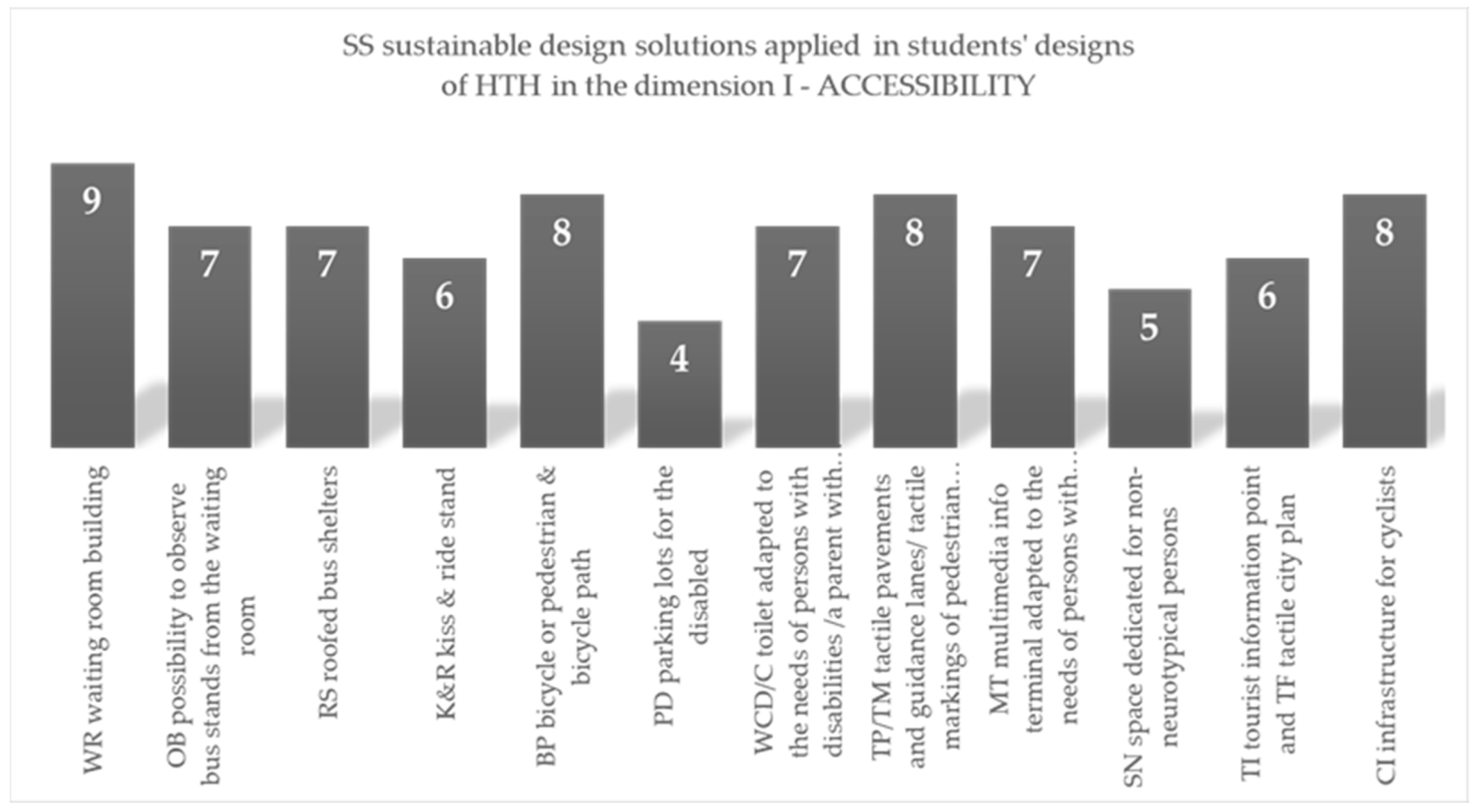
| Students’ Designs of HTH | Application of Sustainable Solutions in I Dimension—ACCESSIBILITY | ||||||||||||||
|---|---|---|---|---|---|---|---|---|---|---|---|---|---|---|---|
| project type | degree of studies 1B/2M curriculum A/LA/T 1) | WR | OB | RS | K&R | BP | PD | WC D/C | TP/TM | MT | SN | TI/TF | IC | number of sustainable solutions depending on the project type | |
| BD—bachelor thesis design/MD—master thesis design | |||||||||||||||
| 1BD | 1B/LA | ✓ | ✓ | ✓ | ✓ | ✓ | ✓ | ✓ | ✓ | 9 | out of 9 | ||||
| 2BD | 1B/LA | ✓ | ✓ | ✓ | ✓ | 4 | |||||||||
| 3BD | 1B/A | ✓ | ✓ | ✓ | ✓ | ✓ | ✓ | ✓ | 7 | ||||||
| 4MD | 2M/LA | ✓ | ✓ | ✓ | ✓ | ✓ | ✓ | ✓ | ✓ | ✓ | ✓ | ✓ | 11 | ||
| 5MD | 2M/LA | ✓ | ✓ | ✓ | ✓ | ✓ | ✓ | ✓ | ✓ | ✓ | ✓ | ✓ | 11 | ||
| 6MD | 2M/A | ✓ | ✓ | ✓ | ✓ | ✓ | ✓ | ✓ | ✓ | ✓ | ✓ | ✓ | 11 | ||
| WD—workshop designs | |||||||||||||||
| 1 WD | 1B/2M A/LA/T | ✓ | ✓ | ✓ | ✓ | ✓ | ✓ | ✓ | ✓ | ✓ | ✓ | 10 | |||
| 2 WD | ✓ | ✓ | ✓ | ✓ | ✓ | ✓ | ✓ | ✓ | ✓ | ✓ | ✓ | 11 | |||
| 3 WD | ✓ | ✓ | ✓ | ✓ | ✓ | ✓ | ✓ | ✓ | ✓ | 9 | |||||
| summary of results —number of applied sustainable solutions | 9 | 7 | 7 | 6 | 8 | 4 | 7 | 8 | 7 | 5 | 6 | 8 | |||
| out of 12 | |||||||||||||||
| Sustainable Solution (SS) Applied in Students’ Designs of HTH | Frequency of Application | |||
|---|---|---|---|---|
| Number | % | |||
| dimensions | I—ACCESSIBILITY | WR waiting room building | 9 | 100 |
| OB possibility to observe bus stands from the waiting room | 7 | 78 | ||
| RS roofed bus shelters | 7 | 78 | ||
| K&R kiss & ride stand | 6 | 67 | ||
| BP bicycle or pedestrian & bicycle path | 8 | 89 | ||
| PD parking lots for the disabled | 4 | 44 | ||
| WCD toilet adapted to the needs of persons with disabilities WCC toilet adapted to the needs of a parent with a child | 7 | 78 | ||
| TP tactile pavements and guidance lanes TM tactile markings of pedestrian crossings/bus stands | 8 | 89 | ||
| MT multimedia info terminal adapted to the needs of persons with disabilities | 7 | 78 | ||
| SN space dedicated for non-neurotypical persons | 5 | 56 | ||
| TI tourist information point TF tactile city plan | 6 | 67 | ||
| CI infrastructure for cyclists | 8 | 89 | ||
| II—ECOLOGY | RG rain garden | 5 | 56 | |
| RT retention tank/basin | 1 | 11 | ||
| BAI an index of biologically active area equal or higher than that specified in the local development plan (20%) | 9 | 100 | ||
| GR ‘green’ roofs | 8 | 89 | ||
| GW ‘green’ walls | 6 | 67 | ||
| GS ‘green’ bus shelters/‘green’ canopies | 5 | 56 | ||
| TG tall greenery (trees) | 8 | 89 | ||
| MG medium-high greenery (shrubs, tallgrasses, etc.) | 8 | 89 | ||
| LG law vegetation (lawns, flower meadows, perennials, grasses, etc.) | 9 | 100 | ||
| CP climbing plants | 7 | 78 | ||
| SF solar or photovoltaic panels/rooftops | 3 | 33 | ||
| RW recycled waste containers | 9 | 100 | ||
| III—FUNCTIONALITY | PP priority for pedestrians | 8 | 89 | |
| RC reducing the number of pedestrian crossings | 4 | 44 | ||
| BP separated bicycle path | 4 | 44 | ||
| SV chicanes and humps to slow down vehicle traffic | 7 | 78 | ||
| RP raised platforms and/or lack of curbs at bus stops | 8 | 89 | ||
| TM ticket machines | 4 | 44 | ||
| WC public toilet | 9 | 100 | ||
| SB weather-sheltered bus stops | 7 | 78 | ||
| PC protective canopies against sun and rain | 9 | 100 | ||
| CS comfortable seats and street furniture/parklets | 9 | 100 | ||
| WD water fountain | 0 | 0 | ||
| LG landscaped greenery | 9 | 100 | ||
| IV—IDENTITY | CC city crest—in Hrubieszów: deer’s head motif | 3 | 33 | |
| CF city flag—in Hrubieszów: red and green colors | 1 | 11 | ||
| CI official city logo—in Hrubieszów: ‘Hrubieszów—Miasto z Klimatem’ | 2 | 22 | ||
| TE totem/a symbolic sign identifying Hrubieszów as the easternmost city in Poland, ‘eastern gate of Poland’ | 5 | 56 | ||
| CG bus station as ‘the city gate’ | 7 | 78 | ||
| MC multiculturalism (Polish, Ukrainian and Jewish culture) | 4 | 44 | ||
| WA traditional forms and details of wooden architecture | 4 | 44 | ||
| LM local building materials (wood, stone, brick) | 7 | 78 | ||
| CW first city well | 3 | 33 | ||
| RB residents’ notice board | 6 | 67 | ||
| VK local vegetable kiosk | 6 | 67 | ||
| NV native vegetation—in Hrubieszów region, e.g., field and meadow vegetation, trees compatible with the natural habitat, etc. | 7 | 78 | ||
| Analysis of Factors That May Have Affected SS Application Rate in Design Proposals | |||||||||||||
|---|---|---|---|---|---|---|---|---|---|---|---|---|---|
| % of SS | pillar | SS application in design proposals in the four pillars: I—accessibility, II—ecology, III—functionality, IV—identity | Factors that may have affected SS application in HTH design proposals | ||||||||||
| 1 | 2 | 3 | |||||||||||
| 100% | SSs APPLIED IN ALL HTH DESIGN PROPOSALS—7 SS | ||||||||||||
| I | WR waiting room building | ||||||||||||
| II | BAI an index of biologically active area in the local development plan | ||||||||||||
| LV low vegetation | |||||||||||||
| RW recycled waste containers | |||||||||||||
| III | WC public toilet | ||||||||||||
| PC protective canopies against sun and rain | |||||||||||||
| LG landscaped greenery | |||||||||||||
Disclaimer/Publisher’s Note: The statements, opinions and data contained in all publications are solely those of the individual author(s) and contributor(s) and not of MDPI and/or the editor(s). MDPI and/or the editor(s) disclaim responsibility for any injury to people or property resulting from any ideas, methods, instructions or products referred to in the content. |
© 2023 by the authors. Licensee MDPI, Basel, Switzerland. This article is an open access article distributed under the terms and conditions of the Creative Commons Attribution (CC BY) license (https://creativecommons.org/licenses/by/4.0/).
Share and Cite
Staniewska, A.; Sykta, I.; Ozimek, A.; Barnaś, K.; Dudek, M.; Marasik, M.; Racoń-Leja, K. Framework for the Design of a Small Transport Hub as an Interdisciplinary Challenge to Implement Sustainable Solutions. Sustainability 2023, 15, 10975. https://doi.org/10.3390/su151410975
Staniewska A, Sykta I, Ozimek A, Barnaś K, Dudek M, Marasik M, Racoń-Leja K. Framework for the Design of a Small Transport Hub as an Interdisciplinary Challenge to Implement Sustainable Solutions. Sustainability. 2023; 15(14):10975. https://doi.org/10.3390/su151410975
Chicago/Turabian StyleStaniewska, Anna, Izabela Sykta, Agnieszka Ozimek, Krzysztof Barnaś, Mariusz Dudek, Magdalena Marasik, and Kinga Racoń-Leja. 2023. "Framework for the Design of a Small Transport Hub as an Interdisciplinary Challenge to Implement Sustainable Solutions" Sustainability 15, no. 14: 10975. https://doi.org/10.3390/su151410975
APA StyleStaniewska, A., Sykta, I., Ozimek, A., Barnaś, K., Dudek, M., Marasik, M., & Racoń-Leja, K. (2023). Framework for the Design of a Small Transport Hub as an Interdisciplinary Challenge to Implement Sustainable Solutions. Sustainability, 15(14), 10975. https://doi.org/10.3390/su151410975