1. Introduction
Disasters have triggered damages and losses around the world and claimed lives throughout the centuries, and continue to do so. Population growth, migration to urban areas, lack of experience, inadequate land use norms, poverty, and climate change are among the stressors that are increasing those impacts and losses worldwide. While developing countries suffer the greatest impacts, history shows time and time again that natural hazards also trigger disasters in developed countries. Between the years 2000 and 2019, the Center for Research on the Epidemiology of Disasters (CRED) reported that there were 7348 events worldwide, claiming 1.23 million lives, and leading to nearly 3 trillion US dollars in economic losses [
1].
Institutionalized approaches to confront the impacts of disasters at the national level began to take shape many decades ago through the establishment of national emergency management agencies or national disaster management committees. The aim of these institutions has been to facilitate the coordination of inter-institutional efforts to respond to the impacts of disasters. Such efforts include the immediate response via search and rescue operations, taking care of those injured or killed, setting up temporary shelters to host those affected, rehabilitating lifelines, and subsequently enabling reconstruction efforts.
While efforts to minimize the impacts of natural hazards were implemented in developed nations several decades ago, efforts to promote such a goal at the international level of the United Nations began with the launch of the International Decade for Natural Disaster Reduction by the United Nations General Assembly during its forty-second session in December 1987 [
2]. The General Assembly requested the organizations and agencies of the United Nations to focus on this issue.
Since then, the United Nations established the Office for the Coordination of Humanitarian Affairs (UNOCHA) to coordinate response efforts on behalf of the United Nations system when a country is impacted by a disaster. In addition, since 1994 the United Nations has launched several international frameworks to advocate for efforts to reduce the risks associated with disasters [
3,
4,
5].
Several decades ago, the space community recognized the benefits of the use of space-based data and information to contribute to disaster response and recovery efforts. It has been facilitating the use of satellite imagery and information generated from that imagery and advocating for an increased use of such space-based information worldwide. At the end of the year 2000, several space agencies joined forces to establish the International Charter Space and Major Disasters [
6]. Since then, this emergency mechanism has been activated more than 800 times to support disaster response efforts worldwide.
In April 2012, the Copernicus Program launched its Copernicus Emergency Management Service that is contributing to disaster response efforts worldwide [
7]. The usefulness of space technologies has been recognized and explicitly included in the Hyogo and the Sendai Frameworks for Action.
Convinced of the usefulness of space-based information in disaster management efforts worldwide, the United Nations General Assembly (UNGA) launched the United Nations Platform for Space-based Information for Disaster Management and Emergency Response (UN-SPIDER) in December 2006 as a program under the United Nations Office for Outer Space Affairs (UNOOSA) [
8].
In recent years, the Copernicus program launched three very useful services: the Global Flood Awareness System (GLOFAS), the Global Drought Observatory (GDO), and the Global Wildland Fire Information System (GWIS). These three services, under the umbrella of the Copernicus Emergency Management Service, are contributing to an improved understanding of these natural hazards and their impacts on urban and rural areas worldwide. Much of the information provided through these services is generated using space-based data. To show UN-SPIDER’s advisory role, this contribution is divided as follows. First, it informs on the efforts carried out by the program and its Regional Support Offices (RSOs) to develop step-by-step procedures to use space-based data to generate maps and information that are tailored to the needs of the disaster management community. Second, it illustrates the efforts carried out by the program to facilitate the link between NDMAs and the International Charter Space and Major Disasters. Finally, it presents information on the advisory support provided by the program to developing countries through national and regional training courses.
2. Materials and Methods
As stated earlier, UN-SPIDER encourages the use of space-based applications and information in developing countries. It works in coordination with UNDRR, UNOCHA, and other UN agencies and organizations in the provision of advisory support to developing countries, and in coordination with the national offices of the Resident Coordinators of the United Nations in the countries it is supporting.
UN-SPIDER tailors its advisory support using the conceptual frameworks of disaster risk management and the disaster management cycle that were developed by the disaster management community a couple of decades ago [
9]. Satellite imagery provides useful information on surface features including built infrastructure, land use, and land cover, which can be used to assess some hazards. In addition, it provides the most up-to-date information on all elements exposed to hazards. In a complementary fashion, digital elevation models developed by the space community provide geospatial information that can be used in combination with in-situ data to assess hazards such as floods, tsunamis, landslides, and storm surges.
The disaster management cycle has been structured in terms of several phases that include prevention, mitigation, preparedness, response, and recovery. Disaster risk reduction efforts are implemented in the prevention, mitigation, and preparedness phases to minimize the level or risk. In a complementary fashion, disaster risk reduction efforts are implemented during the recovery phase to avoid the reconstruction of risks after a disaster. Considering the recurrence of hazards, these phases have been structured as a cycle.
Since its establishment, and with the support of its RSOs and other Centers of Excellence, UN-SPIDER has advocated for the use of space-based information to address those challenges posed by natural hazards and provides advisory support to developing countries. As mandated by the UNGA, the program focuses on developing countries.
As part of its duty to provide advisory support, UN-SPIDER carries out technical advisory missions and surveys to identify the constraints identified by the disaster management community regarding access to data, information, products, and services offered by the space community. Some of the constraints identified by disaster managers in developing countries include the difficulty to access scientific and technical articles in peer-reviewed journals, the lack of step-by-step procedures to process satellite imagery to generate geospatial information in the format used by the disaster management community, and the incapacity to acquire specialized commercial software to process satellite imagery to generate relevant space-based information in a timely manner. Additional challenges identified by UN-SPIDER in these same countries include the lack of awareness of decision makers regarding the wide variety of solutions developed by the space community that can be used in disaster management applications and the lack of training opportunities for technical staff engaged in the generation and use of geospatial information in applications in all phases of the disaster management cycle.
To address these challenges, in 2014 UN-SPIDER began to work with experts from its RSOs and from Centers of Excellence to develop step-by-step procedures to process satellite imagery to generate specific types of space-based information, and to facilitate access to websites that host data, products, and software that can be used to access or generate geospatial information on natural hazards. The information has been incorporated in the UN-SPIDER Knowledge Portal (
https://www.un-spider.org/ accessed on 4 June 2023).
In addition, and as part of its advisory support, the program trains specialists and professionals working in national disaster management agencies, other government agencies, and ministries in developing countries on the use of these step-by-step procedures developed by UN-SPIDER, called recommended practices. In a complementary fashion, it presents to decision makers the benefits of the use of solutions developed by the space community to encourage their use in disaster management and other government agencies.
The impact of these efforts is manifested through the requests for additional advisory support solicited by developing countries. Between 2008 and 2022, UN-SPIDER carried out advisory missions to 50 developing countries in Africa, Asia, Asia Pacific, Latin America, and the Caribbean. Several of these were fact-finding missions, while others focused on training activities or for institutional strengthening. Another way of tracking this impact is through the statistics of visitors to the UN-SPIDER Knowledge Portal. The number of visitors to the site has increased steadily since it was launched in 2009. The Knowledge Portal offers an array of links to websites that host satellite imagery, products and services, and the explicit pages that present the recommended practices are among the most visited monthly. Such impacts serve as a reference for the program to continue facilitating the discovery of space-based data, information, products, and services, and the development of additional recommended practices and additional content than can be used to confront the challenges posed by such hazards.
This process requires information regarding the data, products, procedures, and services offered by the space community; regarding the conceptual frameworks employed by the disaster management community; and an understanding regarding how the disaster management community uses geospatial information.
Information regarding the data, products, procedures, and services provided by the space community and the conceptual frameworks employed by the disaster management community can be extracted from the institutional webpages of space agencies and regional and national disaster management agencies, as well as from the literature published by many institutions and regional and international organizations. In a complementary fashion, the understanding regarding how the disaster management community uses space-based and geospatial information is derived from the findings that emerge from technical advisory missions carried out by UN-SPIDER to developing countries and from continuous communication with the staff of NDMAs in Africa, Asia, Asia Pacific, Latin America, and the Caribbean.
This understanding allows UN-SPIDER to shape what the space community is offering in a format that can be used more easily by the disaster management community.
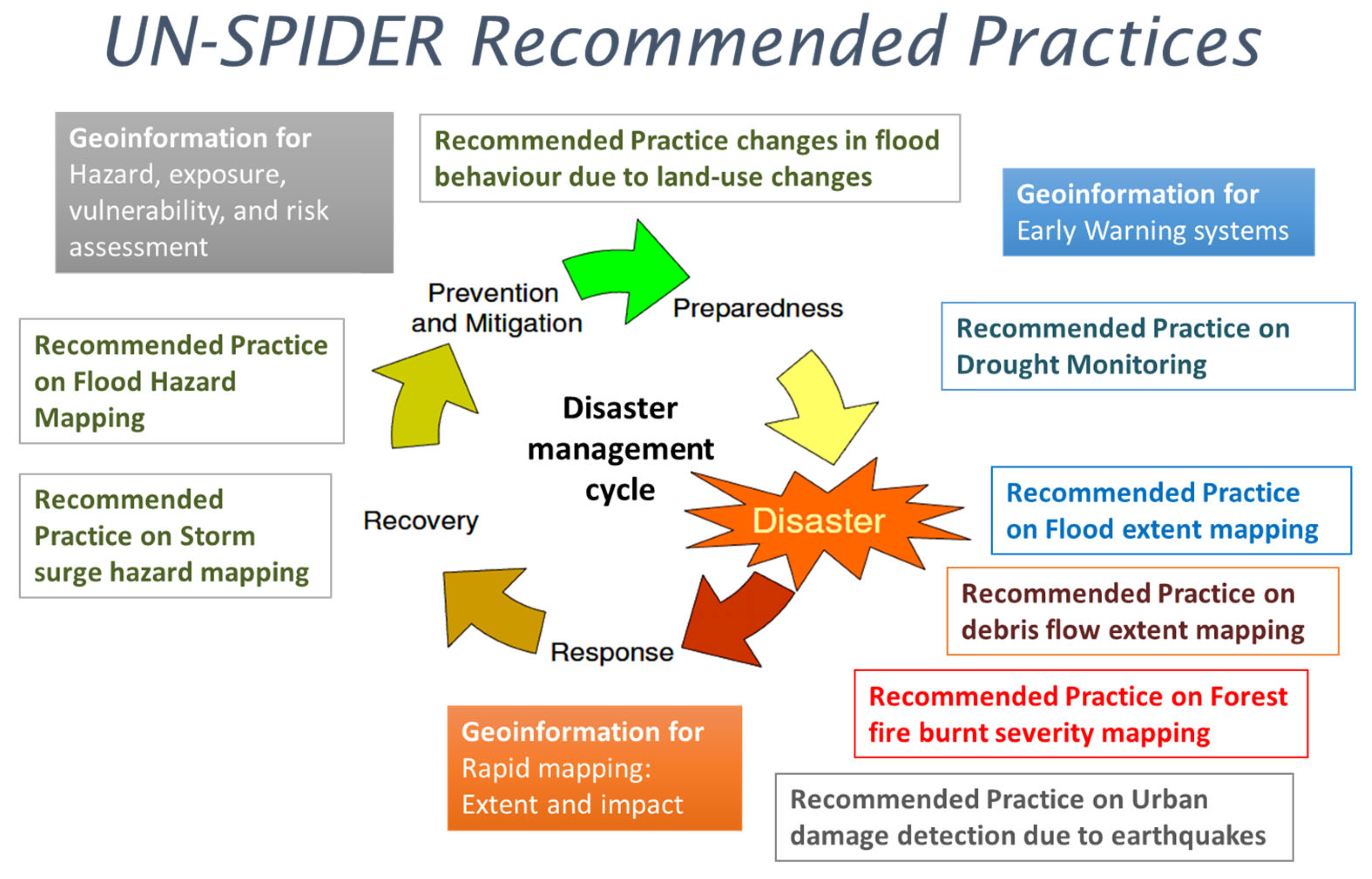
Most of the recommended practices are developed to be used with open software packages such as R Studio, ESA’s Sentinel Applications Platform (SNAP), Quantum GIS, or Python. The recommended practices are developed to be used with satellite imagery that is available free of charge. In addition, each recommended practice includes an example of its use in a specific region of a country. Currently, the UN-SPIDER Knowledge Portal contains 17 recommended practices [
10]. These can be used to assess hazards or exposure of elements to hazards in early warning systems and disaster preparedness, and to map the geographical extent of floods, debris flows, burn severity in case of forest fires, and damages to infrastructure due to earthquakes. With very few exceptions, all of these recommended practices make use of open software languages or tools, and facilitate the use of satellite imagery that is available free of charge.
Figure 1 presents examples of recommended practices and their use in different phases of the disaster management cycle.
In recent years, efforts have been carried out to implement some of these using Google Earth Engine to take advantage of the faster computer speed of cloud-based processing and smaller internet bandwidth requirements. The following sections present information on these recommended practices. The sections are structured to follow the sequence of the disaster management cycle.
2.1. Assessing Hazards
Being aware of the procedures developed by hydrologists, geologists, and other experts to elaborate hazard maps, and of the characteristics of satellite imagery and products developed by the space community, UN-SPIDER has worked with its network of RSOs and other partners to develop recommended practices that can be used to elaborate specific types of hazard maps.
In the case of floods, hydrologists have developed hydraulic equations to model how floods propagate along the channels of rivers and their banks over time [
11]. Computer programs have been developed to facilitate the processing of these equations [
12].
Noting that floods are the more frequent type of hazard in many countries around the world, the space community has developed sensors and procedures to differentiate the presence of water from land [
13,
14,
15]. In addition, the space community has developed digital elevation models that contribute in determining how water may flow in the banks of rivers during floods, or in case of storm surges and tsunamis.
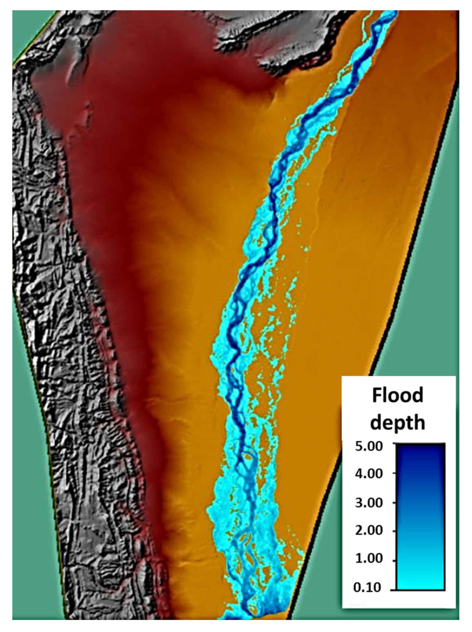
In its role as one of the UN-SPIDER Regional Support Offices, the Space Application Center for Response in Emergency and Disasters (SACRED) of Pakistan’s Space and Upper Atmosphere Research Commission (SUPARCO) developed a recommended practice to assess flood hazard. This recommended practice is available in the UN-SPIDER Knowledge Portal [
16]. It shows the use of digital elevation models such as the World DEM
TM of Airbus Defense and Space to elaborate flood hazard maps employing the Hydrologic Engineering Center’s River Analysis System (HEC-RAS) which has been developed by the United States Army Corps of Engineers [
17]. The recommended practice presents an example of its use in a segment of the Hindus River in the area of the Swat valley in Pakistan. Data from the 2010 flood were used in this example. More information on the 2010 floods is available in the report from the Asian Development Bank (ADB), the World Bank, and the United Nations [
18].
Figure 2 presents the modelled flood depth for this segment of the river.
Storm surge hazard mapping requires precise information on bathymetry and coastal morphology, data on astronomical tides, information on the meteorological conditions of storms triggering surges, and precise digital elevation models of coastal areas. Complex models have been developed to predict storm surges. However, such data may not be available in developing countries, nor experts who may have the skills to use such models to develop storm surge hazard maps.
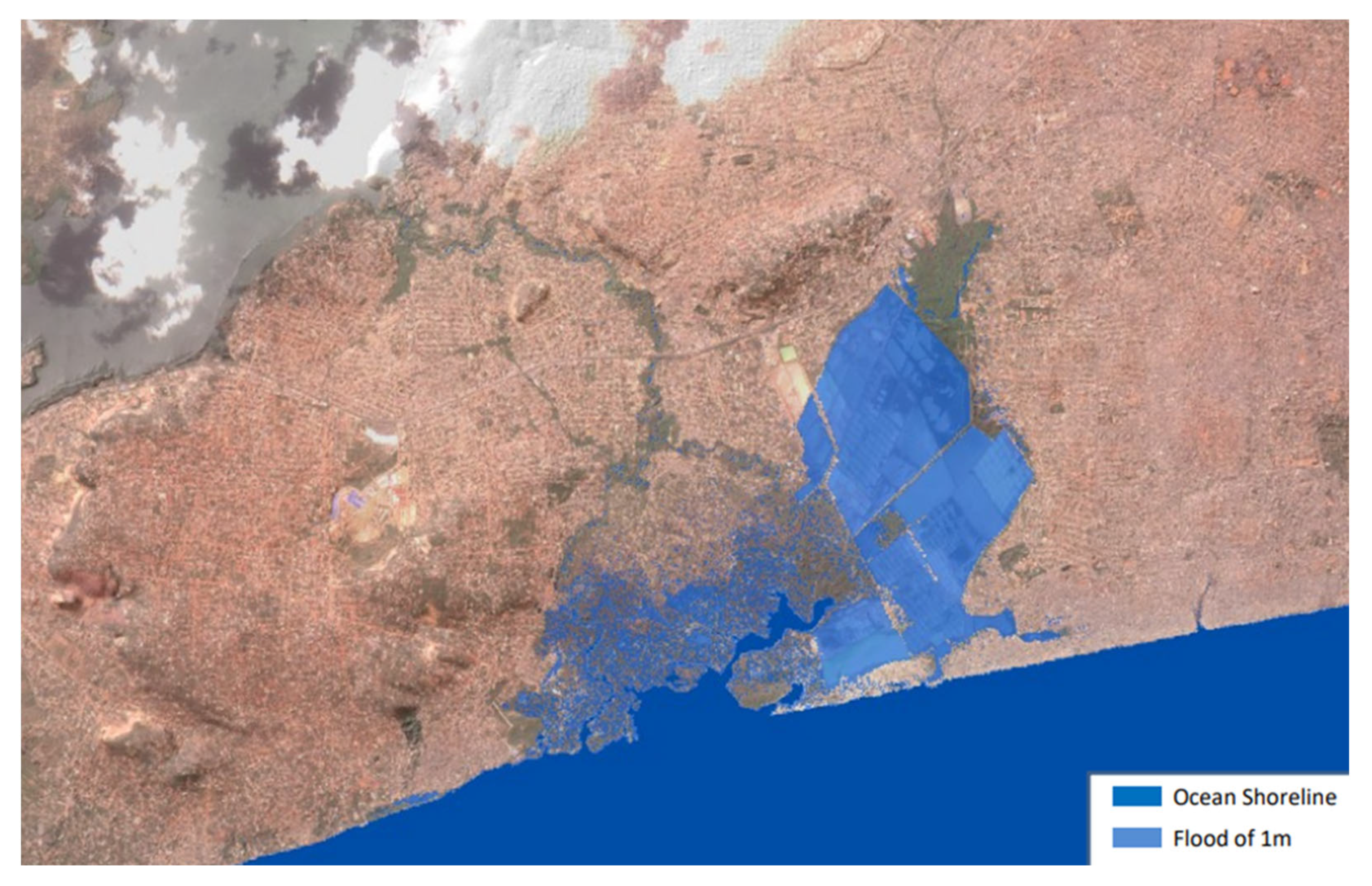
In the year 2018, UN-SPIDER requested Airbus Defense and Space to develop a recommended practice to use the World DEM
TM digital elevation model as an initial approximation to estimate the geographical extent of storm surges in coastal areas [
19]. The procedure was developed using the Quantum GIS software, and a segment of the coastal area of Ghana near Accra was selected for this demonstration. The selection of this coastal area in Ghana stemmed from storm surges which impacted Ghana in recent years.
Figure 3 presents a map of the coastal area of Ghana with the polygon showing the geographic areas which could be flooded in case a storm surge triggers a flood of an elevation up to one meter above sea level.
2.2. Drought Early Warning
Droughts are some of the worst natural phenomena in the world, affecting rural communities engaged in agricultural activities, and in some cases, the supply of electricity in case of energy generated using hydroelectric plants. In extreme cases, droughts may lead to famine, displacement, and even conflict [
20]. They are described as extended periods of time spanning from a season to several years with deficits in rainfall in comparison to a statistical, multi-year average. In recent years, experts have defined three types of droughts: meteorological, hydrological, and agricultural.
Meteorological droughts are currently assessed using parameters such as the standard precipitation index, which compares the amount of current rainfall with historic data on rainfall. In a similar fashion, hydrological drought can be monitored in rivers comparing current and historic discharges in rivers, and well as levels of lakes and other bodies of water. In the case of agricultural droughts, several indices have been developed by the space community that compare the reflection of vegetation in normal periods when the vegetation is green, and in periods where droughts are present, when the vegetation becomes dry.
These indices can be used to monitor the effects of drought on vegetation [
21]. For example, the Normalized Difference Vegetation Index (NDVI) compares the intensity of reflected light in the red and near-infrared bands to determine the degree of dryness of vegetation. Another index commonly used is the Enhanced Vegetation Index (EVI) which includes the blue band in addition to the red and near-infrared bands to better control the effects of atmospheric noise.
In recent years, the Copernicus program of the European Commission introduced the Global Drought Observatory (GDO) that provides useful information on the current state of droughts worldwide. Its geoviewer displays information on the impact of droughts in countries, and includes information on precipitation, temperature, soil moisture, hydrology, and vegetation response [
22]. The frequent updates included in the GDO make it a useful tool to monitor the spatial and temporal evolution of droughts, which is essential in drought early warning systems.
Being aware of the conceptual and operational frameworks developed by the disaster management community regarding early warning systems, UN-SPIDER has requested several of its RSOs to develop recommended practices which are useful in early warning systems related to droughts.
In 2014, the Space Agency of the Islamic Republic of Iran developed a recommended practice to elaborate a series of maps of the Vegetation Condition Index (VCI) that can be used to assess how severe a current drought is with respect to historic droughts which may have taken place in the last two decades. This recommended practice [
23] compares the values of the Normalized Difference Vegetation Index (NDVI) over many years in the same pixels for the same periods of time throughout the year. Through this comparison, one can assess if a current drought is worse than historic droughts in the last two decades, or not as severe as the worst drought in those two decades. UN-SPIDER updated this recommended practice to be used with R Studio and introduced a similar recommended practice using the Enhanced Vegetation Index (EVI). The advantage of using the EVI is that it can better handle the noise due to atmospheric contamination. The pilot area selected to demonstrate this recommended practice is Guatemala, in Central America, which has been experiencing frequent droughts in recent years. The 2009 droughts in the Eastern region of the country led to the definition of the “Dry Corridor” as the region of the country characterized by semi-arid lands, with low agricultural yields, experiencing frequent drought periods [
24].
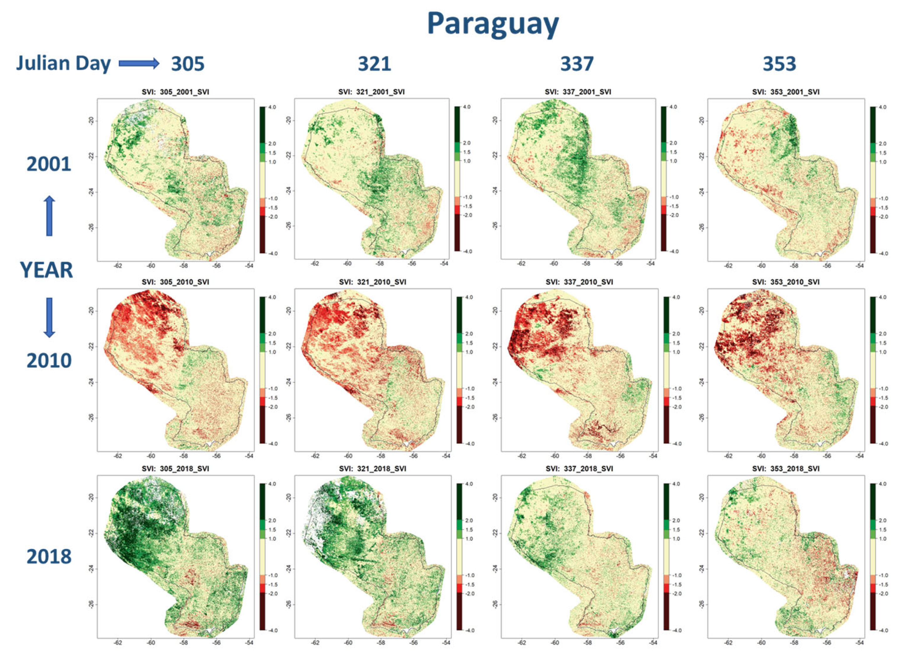
Experts at the Federal University of Santa Maria in Brazil, which is another of UN-SPIDER’s RSOs, developed a similar procedure to assess the Standard Vegetation Index (SVI). This recommended practice can be used to elaborate a similar set of maps of the impacts of drought on vegetation, using as a basis the Enhance Vegetation Index (EVI) that is calculated every 16 days [
25]. The series of EVIs generated every 16 days in the last 22 years can be used to generate the SVI. This index is similar to the Standard Precipitation Index (SPI) that is used by national and regional meteorological institutes. This recommended practice was developed as part of the efforts by UN-SPIDER to implement a project to strengthen drought early warning systems in Central America and the Dominican Republic [
26].
Figure 4 presents some of the maps extracted with this recommended practice for Paraguay covering the period from 1 November to 31 December for the years 2001, 2010, and 2018. An analysis of the entire data series from the year 2000 to the year 2022 suggests that in the year 2010, the vegetation in the northern region of the country was extremely dry when compared to other years. This dry condition is presented with pixels in red-to-dark-red color. In contrast, at the end of the year 2018, the vegetation in the northern region was much greener than the average. This situation is represented with pixels with green-to-dark-green color. The maps for the year 2001 present results that may be representative of vegetation that is neither too green, nor too dry.
Taking into consideration the fact that NDVI and EVI composite products are updated every 16 days, the maps of the VCI and the SVI can be updated every 16 days to track the temporal and spatial effects of drought in any region of any country of the world using data from the MODIS sensors on board the Aqua and Terra satellites. These recommended practices facilitate the visualization of those regions in the countries most affected by droughts, and the severity of such droughts in comparison to historic droughts in the same region.
2.3. Exposure and Disaster Preparedness
Satellite images provide the most up-to-date information on elements exposed to hazards and on the road network which can be used for evacuation to safe areas. For example, in the case of a tsunami, information on the type of infrastructure exposed, the type of people inside buildings which may be exposed, and the layout of the geographic area where the infrastructure is located is essential to assess whether evacuations to safe areas far away from the coast are feasible, or whether vertical evacuation alternatives need to be identified. The information on the most up-to-date infrastructure allows for the determination of evacuation routes to safe areas.
Several years ago, the space community began developing geospatial information on the location of urban areas and estimates of the number of people living in such areas. The Joint Research Center of the European Commission (EC-JRC) developed the Global Human Settlement Layer [
27]. Very recently, the German Aerospace Center (DLR) launched its World Settlement Footprint 3D that already includes information on average building height, total area, and fraction of building in urban areas [
28]. This novel geospatial tool is a follow-up to the previous version launched by the German Aerospace Center (DLR) called the Global Urban Footprint (GUF).
Experts from UN-SPIDER developed a recommended practice that can be used in disaster preparedness to identify several types of exposed elements such as the estimated number of people exposed, as well as different types of vegetation (cultivated land, forest, grassland), bare land, and artificial surfaces which may be exposed to hazards such as floods, tsunamis, or forest fires [
29]. This recommended practice uses geospatial data on population provided by WorldPop [
30], and data on land cover from the Globe Land 30 tool developed by the National Geomatics Center of China (NGCC) [
31]. Taking into consideration the frequent floods that Malawi has been experiencing in recent years, this recommended practice used the geographic area of the Shire River in Malawi including areas of the Nsanje district around Chiromo as an example. The example addressed the floods which impacted this area in January 2015 [
32].
2.4. Disaster Response
Noting the usefulness of the detection and mapping of areas affected by hazards such as floods, landslides, debris flows, oil spills, lava flows, forest fires, or tsunamis with satellite imagery, UN-SPIDER has supported National Disaster Management Agencies (NDMAs) in their request for the activation of the International Charter Space and Major Disasters. In a complementary fashion, since 2014 UN-SPIDER has encouraged NDMAs to become authorized users of this mechanism so that they can request the activation directly. Through its efforts, the program has engaged 23 NDMAs in countries in Africa, Asia, Asia Pacific, Latin America, and the Caribbean as authorized users. Many of these NDMAs have directly activated the Charter as needed. Furthermore, since its establishment UN-SPIDER has requested the activation of the International Charter on 69 occasions at the request of NDMAs and organizations of the United Nations.
In the case of floods, a few decades ago the space community began to launch satellites with Synthetic Aperture Radar (SAR) sensors that use specific bands of the microwave portion of the electromagnetic spectrum [
33]. SAR sensors emit signals to the ground and receive the backscattered signals. The backscatter intensity depends on multiple factors [
34].
To contribute to the mapping of the geographical extent of floods, the Space Research Institute of the National Academy of Sciences of Ukraine and National Space Agency of Ukraine (SRI-NASU-SSAU) developed a recommended practice on radar-based flood mapping [
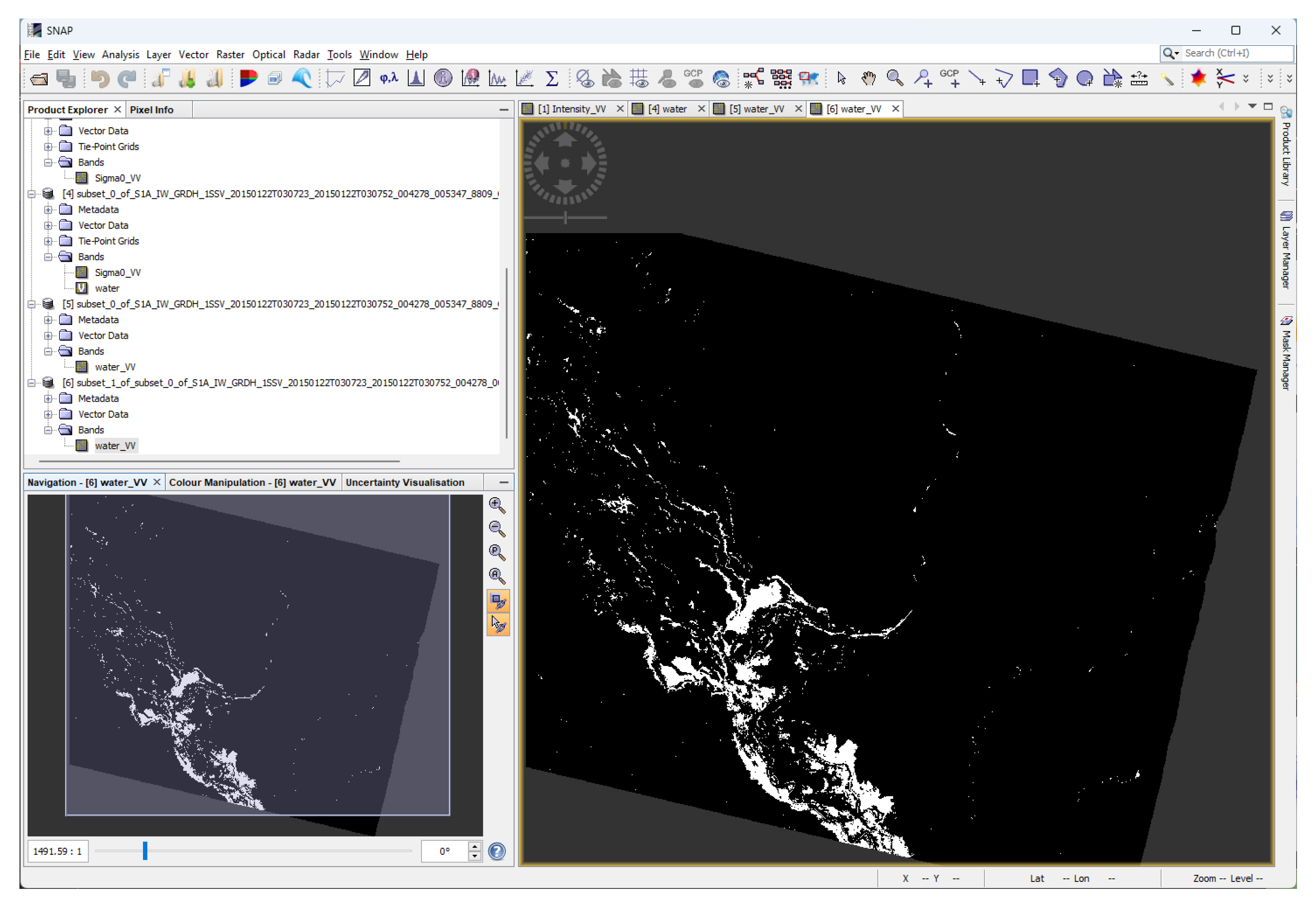
35]. This recommended practice uses the Sentinel Application Platform (SNAP) to process radar imagery such as the one acquired with the Sentinel 1 satellites to extract the geographical extent of flooded areas. This recommended practice was updated by UN-SPIDER to be used in the environment of Google Earth Engine to speed up the extraction of flooded areas by taking advantage of processing in the cloud [
36]. This recommended practice uses as an example the floods which impacted the southern region of the Nsanje district in Malawi in January 2015.
Figure 5 presents a screenshot of the SNAP software with the demarcation of the flooded areas in the region of Nsanje. Additional information on these floods is available in the Copernicus Emergency Management Service on the Rapid Mapping Service webpage [
37].
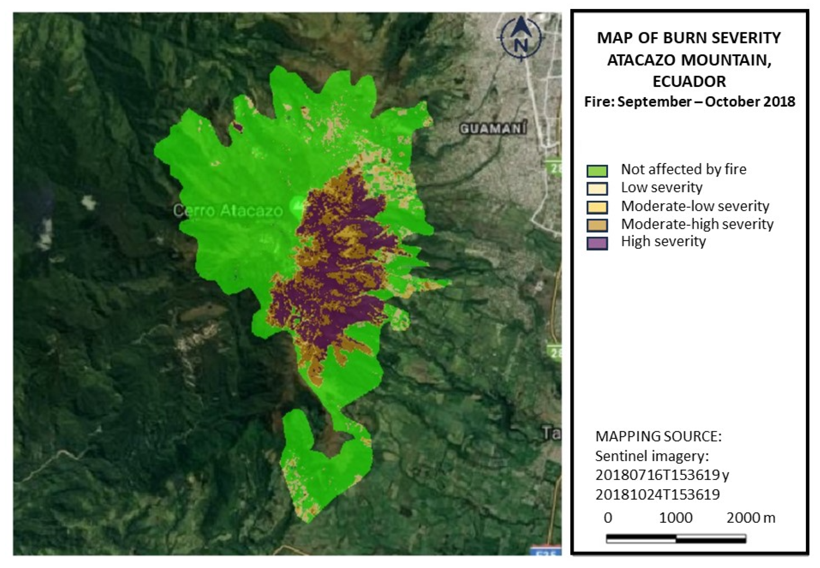
Experts from the Agustin Codazzi Geographic Institute of Colombia (IGAC) developed another recommended practice to map the burn severity of forest fires [
38]. Burn severity is assessed using the Normalized Burn Ratio (NBR), which is calculated employing a similar formula to the one used to calculate the NDVI. The difference between the NBR and NDVI is that in the NBR is based on the difference in the reflectance of the vegetation in the near-infrared (NIR) and the shortwave infrared (SIR) bands of the electromagnetic spectrum. In contrast, the NDVI compares the reflectance of the vegetation in the red and the near-infrared bands of the electromagnetic spectrum. The burn severity is calculated by comparing NBR values before and after the fire [
39].
This recommended practice uses satellite imagery from the Sentinel 2 or the Landsat satellites and Quantum GIS software or Google Earth Engine. The example used to present this recommended practice is the forest fire which took place in the Atacazo mountain in the Pichincha province in Ecuador in September and October 2018. The burn severity was extracted using Sentinel 2 images before and after the forest fire. More information on this forest fire is available from the Risk Management Secretariat of Ecuador [
40].
Figure 6 presents the map elaborated with this recommended practice.
In recent years, the Copernicus program joined forces with the National Aeronautics and Space Administration (NASA) of the United States and the Group of Earth Observation (GEO) to launch the Global Wildfire Information System (GWIS) [
41]. One interesting feature of GWIS is the database of historical fires which is available for every country and spans from 2002 to 2019 at the time this contribution was elaborated. This database allows forest fire managers to compare historical and more recent information on forest fires at national, provincial, or district levels. The database includes data on burnt areas extracted using the Moderate Resolution Imaging Spectroradiometer (MODIS) on board the Terra and Aqua satellites.
2.5. Training Activities to Promote the Use of Recommended Practices
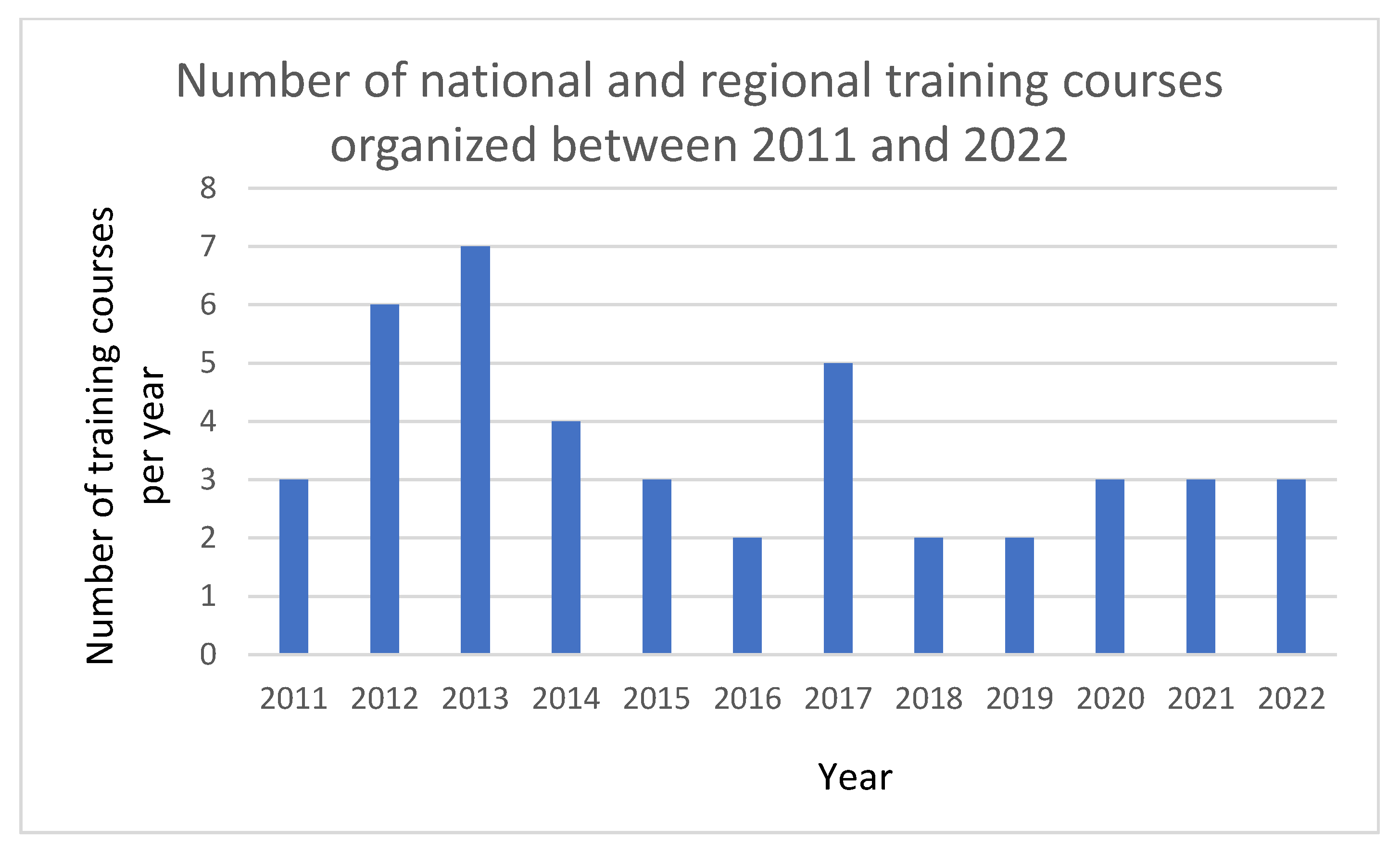
Responding to the needs manifested by NDMAs regarding training activities, UN-SPIDER organizes national and regional training courses on the use of these recommended practices and other solutions developed by the space community. Experts from the UN-SPIDER RSOs contribute as instructors and participants including specialists and professionals working in NDMAs and other government agencies. As shown in
Figure 7, between 2011 and 2022 the program organized 43 national and regional training courses.
The program likewise raises awareness about initiatives developed by the space community through its advisory missions to developing countries and during the conferences and expert meetings organized by the program.
3. Results and Discussion
Through its efforts, the program has enhanced the use of data, products, and services offered by the space community in developing countries in Africa, Asia, Latin America, and the Caribbean.
3.1. Use of Recommended Practices
Using Google Analytics, UN-SPIDER has been able to note that several of these recommended practices are among the most visited pages in its Knowledge Portal over the years. These results encourage the program to continue developing and uploading new recommended practices so that they can be used worldwide.
3.2. Bridging the Space and the Disaster Management Communities
Efforts by UN-SPIDER to link the International Charter Space and Major Disasters with NDMAs of developing countries have led to the activation of the International Charter by many NDMAs over the years and the incorporation of 23 NDMAs as authorized users of this mechanism. Since 2007, the program has been requested to activate the International Charter on 69 occasions to support disaster response efforts. Efforts are underway to encourage NDMAs to also benefit from the space-based information provided by the Copernicus Emergency Management Service.
Challenges faced by technical staff at the NDMAs and other government agencies and ministries in developing countries include the lack of awareness of high-ranking authorities on the benefits of the use of such tools, the lack of scientific and technical libraries to become aware of procedures developed by the space and the geospatial communities, the lack of access to training opportunities, and the lack of resources to acquire high-resolution satellite imagery and commercial software. In addition, there are few procedures using open software to elaborate space-based information for use in disaster management applications. Furthermore, scientific and technical articles do not often really present the step-by-step procedures, or refer to the use of expensive, commercial software programs or packages used in such procedures.
Building on the efforts of the space community and with the support of its RSOs, UN-SPIDER has been able to enhance the use of space-based data, information, and products by NDMAs and other government agencies and ministries that must address the challenges posed by disasters in developing countries. The approach taken by UN-SPIDER includes the implementation of several efforts in parallel:
The set-up of a webpage called the UN-SPIDER Knowledge Portal that serves as a gateway to the information, data, products, and services offered by the space community. The Knowledge Portal also contains the recommended practices and other relevant information on activities carried out by UN-SPIDER and the space community.
The institutional strengthening of NDMAs and other government agencies in developing countries through the provision of advisory support on a continuous basis, mobilizing experts for training courses, and for awareness-raising efforts targeting decision makers.
One of the key issues that UN-SPIDER addresses is the continuous communication and engagement of technical staff in the NDMAs and other government agencies and ministries to institutionalize the use of the solutions developed by the space community. As a result, more NDMAs and other government agencies are using the UN-SPIDER recommended practices and are requesting additional advisory support from the program to institutionalize the use of space-based information.
Based on the experience of UN-SPIDER, one can foresee several additional lines of research to enhance the use of space-based data. For example, there is a need to carry out research on:
Procedures to facilitate the combination of archived and up-to-date information to monitor geological and geomorphological hazards such as slow-moving landslides and volcanic activity. Once developed and tested, these procedures could be used in early warning systems addressing these hazards.
The combined and complementary use of satellite imagery of different resolutions.
The combined and complementary use of satellite imagery and data from Global Navigation Satellite Systems (GNSS) to monitor hazards and for improved disaster response efforts.
The use of novel satellite imagery, data, and products to address the challenges posed by climate change, which are exacerbating natural hazards.
UN-SPIDER transmits these needs to the space community and to its RSOs so that such institutions can then carry out the proposed research and develop solutions that can be promoted by the program.


