Article

Planning Recreation around Water Bodies in Two Hard Coal Post-Mining Areas in Southern Poland

by
Iwona Kantor-Pietraga
*,
Robert Krzysztofik
and
Maksymilian Solarski
Institute of Social and Economic Geography and Spatial Management, Faculty of Natural Sciences, University of Silesia, Będzińska 60, 41-200 Sosnowiec, Poland
*
Author to whom correspondence should be addressed.
Sustainability 2023, 15(13), 10607; https://doi.org/10.3390/su151310607
Submission received: 27 April 2023 / Revised: 29 June 2023 / Accepted: 3 July 2023 / Published: 5 July 2023

Abstract

:
Green and blue infrastructure is a unique aspect of sustainable development in post-industrial and post-mining cities. The article examines the issue of the characteristic post-mining lake district in one of Europe’s largest urban and hard coal mining regions—the Katowice Conurbation in Southern Poland. This article aims to clarify the conditions and problems of developing post-mining water bodies as an element of blue and green infrastructure, with a particular focus on the issue of developing recreational functions. The latter aspect was analyzed using extensive CAVI (Computer-Assisted Web Interview)/CATI (Computer-Assisted Telephone Interviewing) surveys conducted among residents, in-depth stakeholder interviews, and strategic and planning document analysis. This research confirmed that residents and local authorities treat post-mining reservoirs as necessary for creating green and blue infrastructure. Recreational functions were perceived as one of the elements of urban policy, in which the preservation of valuable ecosystems created around reservoirs has the same place. An essential element of the research findings is also the typology of post-mining reservoirs presented here, which allows for a better understanding of the development dilemmas of these areas in a highly urbanized and post-mining area.

1. Introduction

The urban landscape results from overlapping social and economic endogenous (intra-urban) and exogenous (external) functions [1,2,3]. Undoubtedly, the most notable transformations involve spaces whose development changes from one based on exogenous functions to one based on endogenous functions. A significant example of such a transformation concerns functional changes that lead to the disappearance of mining and industrial functions and the formation of a space with recreational functions in this location [4,5,6]. An industrial or mining space that used to function thanks to the interaction with the whole world (the export of raw materials) or just a given country becomes a space whose beneficiaries are mainly the inhabitants of the city or, less often, the region. The discourse on the transformation of post-mining and post-industrial areas in the urban landscape is one of the essential elements of the discourse on contemporary cities [7,8,9]. However, a gap exists in these studies, namely the issue of post-mining water reservoirs located in large cities that are considered potential spaces for developing leisure functions. Even more evident is the problem of research on post-mining lake districts in metropolitan cores. The research gap mentioned above has two sources. Firstly, more often than not, such reservoirs are single objects constituting a part of larger zones within a post-mining derelict area [10]. Therefore, they are discussed when analyzing the derelict area as a whole [11,12,13,14,15,16]. The second issue is the relatively small number of large cities and agglomerations within which the scale of this phenomenon would be evident. However, there are large cities and regions in the global space where post-mining reservoirs at various stages of their development form the core of recreational functions in the urban landscape. However, scientific work has focused on environmental issues related to possible water pollution or decontamination, the relative transformation from gray infrastructure to green and blue infrastructure [17]. The existence of water bodies in urban spaces, regardless of their genesis, constitutes an original element of the landscape of these cities. However, it remains a challenge to policymaking and planning [18,19].
The role of the water of post-mining water bodies within the boundaries of large metropolitan areas has grown in importance in recent years for two reasons. The most recent is related to the COVID-19 pandemic. Undoubtedly, the restrictions on movement stemming from lockdowns boosted interest in recreation in open recreational and green areas [20,21]. Moreover, the health-promoting role of green and blue infrastructure has broader dimensions than those associated with the recent pandemic [22,23,24].
Undoubtedly, the role of water bodies as part of the development of recreational functions grows in places where they can enhance residents’ quality of life and even make living in this neighborhood a more attractive proposition [17,25]. The group of cities where these needs are coming to the fore are post-industrial and post-mining cities that are shrinking.
However, spatial planning in post-mining and shrinking cities at the same time located on several developable water bodies poses many challenges—organizational, financial, political, or social [26,27,28,29,30]. This article aims to clarify the conditions and problems of developing post-mining water bodies as an element of blue and green infrastructure, with a particular focus on the issue of developing recreational functions. We conducted the analysis based on multifaceted research and a proposed typology of recreational areas around post-mining water bodies. This typology will be an element of further research, showing a cross-section of types of post-mining reservoirs in the study area.
The study considered water bodies developed to varying degrees located in the two largest cities at the core of the Katowice Conurbation in Southern Poland—Katowice and Sosnowiec. Alongside Germany’s Ruhr region, the Nord-Pas-de-Calais in the French–Belgian border region and the Ostrava region of the Czech Republic, the Katowice Conurbation is one of the European Union’s largest post-mining areas related to hard coal mining and is a place where anthropogenic water bodies have formed.

2. Research Overview

Research on the role and functions of water bodies in the city refers to several essential discourses. From the point of view of this article, there are three such essential discourses. The first concerns water bodies in terms of their urban and ecological role. The second concerns water bodies as a form of brownfield development, and the third concerns the recreational function of city water bodies [31].
Water bodies’ urban and ecological context has already been the subject of significant amounts of the scientific literature, mainly on the discourse on ecosystem services and green and blue infrastructure (GBI) [32,33,34,35]. Research primarily focuses on the direct interaction of social and economic activity concerning water bodies as a landscape or natural component, and sustainable development in broader terms [36].
From the ecological point of view, what is undoubtedly essential is the division of water bodies proposed by Forman [37] (p. 179), who distinguished 16 types with varying degrees of oxygenation: natural ponds, ponds, oxbow lakes in floodplains, beaver ponds, dam ponds, ponds in former gravel pits, ponds on golf courses, ponds in municipal parks, public swimming pools, swimming pools in backyard plots, backyard ponds in backyard plots, ponds at institutions or economic centers, congestion ponds, ponds with rainwater runoff, ponds at sewage treatment plants, and ponds at industrial sewage treatment plants.
Interesting earlier typologies of water bodies considering various environmental and development attributes were proposed by Bernhardt in 1991, Peterken in 1996, and Peterken and Moss in 1988–1996. Their synthetic discussion with additions was presented by O’Sullivan [38]. In Bernhardt’s typology, lake and reservoir use was juxtaposed against trophic status. The author based his typology on the trophic state of water. Individual trophic types refer to drinking water, bathing, recreation (non-bathing), water sport (non-bathing), fish cultures, commercial fisheries, landscaping, irrigation, industrial processes, transport, energy (generation), and energy (cooling).
In terms of this typology, all types related to recreation (bathing, recreation (non-bathing), water sport (non-bathing), and fish cultures are of interest in this article. Also of interest is O’Sullivan’s project based on Peterken’s research from the 1990s. This typology refers to the issue of naturalness as applied to lakes. It distinguishes original, present, past, potential, and future naturalness. In the case of post-mining regions, such as the one analyzed in the article, water bodies can paradoxically cover all five types. On the edge of a heavily urbanized area, where mining was not carried out, there are small reservoirs with the features that O’Sullivan indicates for original naturalness. Due to their being created at various times, the remaining types of reservoirs can be referred to as the other four types. Equally interesting is O’Sullivan’s typology based on research by Moss and Peterken. In this case, the type of lake is very closely related to the type of forest area. There are six types of forests (1—virgin forests; 2—primary/ancient near-natural forests and woodlands; 3—primary/ancient near-natural or semi-natural forests and woodlands; 4—secondary, primary-disturbed, and semi-natural woodlands; 5—secondary, semi-natural woodlands; and 6—plantations) that determine the type and environmental characteristics of the reservoir located within each. The Katowice Conurbation has green areas of Types 4, 5, and 6. Types 2 and 3 are rare and tend to occur on the region’s outskirts in post-mining regions.
From the point of view of research on the urban planning role of water bodies, it is vital to mention how water reservoirs and GBI, in a broader sense, impact on the attractiveness of the location of new residential functions. For example, it is manifested in higher property prices near permanent water reservoirs [39].
Undoubtedly, the issue of post-mining lakes addressed in the article relates chiefly to the issue of brownfield site development. The type of reservoirs was brownfield or part of them for a longer or shorter time. Due to formally different definitions of this type of area in master plans, some of the reservoirs and their surroundings still constitute a brownfield. A characteristic feature of studies on post-mining inner-city reservoirs as a revitalization challenge to date is the relatively limited scientific output. This also applies to hard-coal post-mining regions [40,41,42,43], including the Katowice region, which is analyzed in this article. The context of spatial planning and urban policymaking can be found in the studies by Dulias [44] and Krzysztofik et al. [45]. Studies conducted so far on post-mining areas highlight the role of large opencast mines in the urban landscape and the complex problems of land-use directions/conflicts and the flexibility of key stakeholders or financial and organizational shortcomings [46,47]. The issue of residents’ participation in planning post-mining areas is also of undoubted importance. In post-socialist countries, which are marked by conditions of financial scarcity, public opinion often diverges from the vision of the local authorities, who organize urban space ‘tailored to fit’ or based on a grand coalition. This phenomenon is also evident in the creation of recreational areas in large cities, the development of which is based on the location of water bodies. In this case, researchers highlight issues such as residents’ needs for rest and recreation as a form of health promotion [48,49], social expectations regarding the development of recreational areas in the city; or the competition of in situ leisure merits with those of places requiring relocation [50]. In the case of the Katowice region, cognitive conflict is also significant, including whether a post-mining region can also be a recreational region at the same time and whether we can replace ‘black’ or ‘brown’ infrastructure with green and blue infrastructure [51,52,53]. The importance of problems related to water quality and the selected morphological features of lakes is evident in the study by Nelson et al. [54]. The authors of this large study point to the essential role of the summer depth of water bodies and, to a lesser extent, water purity. In the case of the latter issue, it was rightly pointed out that not all visits to a body of water involve bathing or fishing.

3. Methods, Materials and Study Area

3.1. Methods and Materials

In this section, we want to draw attention to the diverse materials and methods used to investigate the recreational functions of water bodies in post-mining areas in the core of the Katowice Conurbation. As this is the first study of the recreational functions of intra-urban reservoirs in such a highly urbanized area, diverse research methods make it possible to look at the problem holistically.
The article uses the authors’ own materials and those obtained from registry data. The former materials concern the results of Computer-Assisted Web Interviews and Computer-Assisted Telephone Interviewing (CAVI/CATI) surveys. Six hundred questionnaires were collected, three hundred for each city analyzed (Katowice and Sosnowiec). These anonymous questionnaires took account of the gender (women and men) and age range of adult respondents: 18–29, 30–49, 50–64, and over 64.
We asked respondents three questions (Q) and offered several response options (A).
(1)
(Q): How often do you visit water bodies in and around the city?
(A): Every day/a few times a week/a few times a month/a few times a year/not at all.
(2)
(Q): Should poorly developed water bodies be left to experience using their natural values or rather be developed to strengthen their recreational functions?
(A): Leave to nature/enhance recreational functions/try to balance/do not know.
(3)
(Q): What problems do you see concerning water bodies and their surroundings?
(A): Poor accessibility by public transport/poor accessibility by car, including lack of car parks/no possibility of swimming/no possibility for recreational use of the water in other ways/poor infrastructure around the reservoir/too-intensive development/devastation or littering/overabundance of visitors/no information about the reservoir and attractions/nature threats—wild animals, ticks (infected with Lyme disease), vipers/none of the above (other).
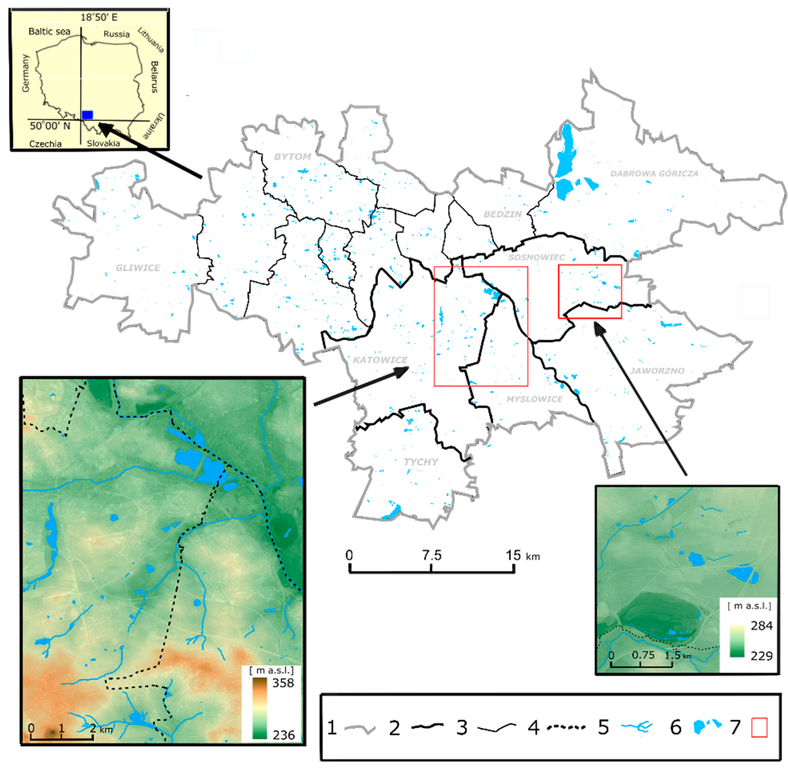
The results of the CAVI/CATI survey were processed using statistical methods, and the calculations were prepared using the Statistica 13 software package. The Chi-Square Test [55] of independence was used to study the associations in the data on the features analyzed.
Moreover, the authors’ materials included interviews with 20 stakeholders on local government policy regarding the areas in question. Representatives of municipal authorities, angling associations, local entrepreneurs, and people active in the media for pro-ecological development spoke about the role of post-mining water bodies. In-depth interviews were conducted in person or by telephone. Representatives of the municipality of Katowice gave written responses to questions.
GIS technology was used in the study primarily to produce an inventory of water bodies based on cartographic studies at a scale of 1:10,000, dating from the end of the 20th century. These were updated based on aerial photographs taken in the second decade of the 21st century (for this purpose commercial Map Info 10 software was used). Thanks to the vectorization of the reservoirs, it was possible to determine their number and other surface characteristics.
The following GIS tools were used in the study: SAGA GIS 7.8.2 application, QGIS, and MapInfo Professional 10.0. SAGA GIS software was used to analyze raster maps of contemporary terrain models, using the LIDAR method. In the QGIS and MapInfo software, based on cartographic materials and aerial and satellite photos, we digitized water bodies in the survey area at the beginning of the second decade of the 21st century. A DJI Phantom 4 uncrewed aerial vehicle was used for two purposes in this research. Firstly, this was the matter of establishing the shoreline in areas of strong eutrophication of water bodies. Other methods, especially those based on cartographic material, do not provide benefits related to updating the facts. In many places, there has also been human interference with the coastline. In hard-to-reach places, it would not be possible to determine the most up-to-date scale of changes. Secondly, we used a drone to take a series of photos, some of which are presented in the article.
In the research, we included an analysis we also conducted of the records of the strategies of the two hard-coal post-mining cities located in the core of the Katowice Conurbation (Katowice—Master Plan—Study of the Conditions and Directions for Spatial Development [56]; Strategy for the Development of City “Katowice 2030” [57]; Strategy for the Development of City Sosnowiec until 2020 [58]; Sosnowiec—Master Plan—Study of the Conditions and Directions for Spatial Development [59] and regional strategies—Program of strategic activities of the Upper Silesian—Zagłębie Metropolis until 2022 [60]; Silesian Voivodeship Development Strategy “Śląskie 2020+” [61]). This information provided significant findings for developing recreational functions around post-mining water bodies. We also conducted an analysis based on press articles from local websites concerning the types of water bodies in question and their use for recreational purposes (e.g., [62]). In addition, the surveyed towns’ websites were analyzed [63,64] for institutions and businesses directly related to managing water bodies and their surroundings.

3.2. Study Area

The relationship between water bodies and urban areas varies. It depends primarily on the size of the city and the water bodies and whether there is a single water body or a more significant number of them, including a post-mining lake district. The distribution of post-mining water bodies in the study area is shown in Figure 1. The study area was water bodies in the largest two cities in the core Katowice Conurbation in Southern Poland. The total area of the cities of the conurbation amounts to 1270.4 km2.
The geomorphological form of the water bodies is also important. The most general distinction is between those formed by continuous denudation (subsidence troughs) and discontinuous denudation (opencast pits and sinkholes around former mine shafts) [65]. It is also essential because of the type of raw material exploited in connection with which the water body was forming—coal, sand, dolomite, or limestone.
In the research area, we distinguish post-working reservoirs in subsidence basins, dam reservoirs, dike reservoirs formed in artificial bowls, and polygenetic water bodies formed due to the interaction of several factors. Reservoirs in the study area are characterized by small surfaces and depths, which translate into relatively small amounts of water [66]. Due to the morphometric characteristics (Table 1) of water bodies in the Katowice Conurbation, most are classified as polymictic reservoirs (whose waters are mixed to the bottom several times a year). Dimictic and meromictic reservoirs constitute a small group [67]. The water quality of the vast majority of water bodies located in the Katowice Conurbation is bad. Most are reservoirs with varying degrees of eutrophication process development, usually from eutrophic to hyper peat [68,69], which stems from the influx of phosphates and nitrates from various sources of pollution (industrial, agricultural, and municipal) [68]. Sediments are a very good indicator of water status in reservoirs. Based on the elements in these water bodies, it is possible to determine the quality of their water and their suitability for recreational purposes [70,71].
Water bodies used for recreation in the Katowice Conurbation and on its outskirts do not meet the geo-ecological conditions for safe use for recreational and leisure purposes. Due to repeated crossings of the regional levels of the geochemical background of metals, non-metals, and metalloids in their bottom sediments, using them for recreational activities directly affects the participants’ health. In order to eliminate the threat to the environment and human health, it is necessary to take reclamation measures to remove bottom sediments [70].
The presence of metals, non-metals, and metalloids in bottom sediments should be considered when classifying water bodies as suitable for recreational use, regardless of the hydrochemical indicators used to assess this suitability [70].
This is crucial for the land use near the water bodies. This paper presents a fragment of an anthropogenic lake district in the Katowice Conurbation, one of the EU’s three most distinct hard-coal post-mining areas. Interestingly, the common coal genesis of these regions distinguishes them in terms of the specificity of the largest anthropogenic water bodies. The large water bodies were created in the Ruhr by gravel extraction (Sechs-Seen-Platte in Duisburg) and the reclamation of post-mining areas (Phoenix-See in Dortmund or Krupp Park in Essen). Water bodies created due to the direct activity of hard-coal mining are relatively small and most often naturalized. There are fewer of them compared to the Katowice Conurbation. The post-mining lake district on the Franco-Belgian border is in direct contrast to the Ruhr. All the largest reservoirs of water and most of the smaller ones were created here by subsidence. Water-filled depressions have formed a network of reservoirs of water resembling natural lakes.
The Ostrava region in the Czech Republic has the characteristics of post-mining lakes formed both in Germany and in the Franco-Belgian border region. On the one hand, one can see large riverside water bodies in the Ostrava area, and on the other, there is a large reservoir in a post-mining sinkhole in Karvinské Moře. A feature of the Ostrava region is the large proportion of natural reservoirs not formed due to mining activity. Many of these reservoirs are located in clusters along rivers [73].
The genesis of anthropogenic lakes in these three regions was determined by the method of technical coal exploitation. In France and Belgium, this was the “cave-in” method, causing extensive land depressions to fill with water. This model is partly evident in the Katowice Conurbation and the Ostrava region. Small water bodies resulting from subsidence are also characteristic of the Ruhr. In the Katowice Conurbation, however, a characteristic feature is the flooded large outcrops of sand used as part of the liquid backfill mixture to fill the depleted shafts and tunnels of underground coal mines [44,45]. A mining railway system transported this sand to the shafts of the coal mines. These mines were often located near the city centers and had no connection with the flowing rivers of today which are so characteristic of the Ruhr and Ostrava regions. The sand deposits in coal mines originate from glacial accumulation [44]. These are undoubtedly unique features of the genesis of the anthropogenic water bodies in the Katowice Conurbation compared to the hard-coal post-mining regions in other EU countries (Table 2).
The location of the Katowice Conurbation in the northern part of the Upper Silesian Anthropogenic Lake District was described by Rzętała [10] and covers 6766 km2. At the beginning of the 21st century, the number of water bodies within this lake district was 4773, and its lake density was 2.74% [66]. These values are presented in Table 3.
The difference between the lake density in the Upper Silesian Anthropogenic Lake District and the highly urbanized Katowice Conurbation area results from the fact that many of the reservoirs outside the cities are concentrated in complexes of medium-sized breeding ponds. The upland topography within the Katowice Conurbation and the infiltration of surface waters related to mining operations are not always favorable factors.

4. Results

Planning with regard to using anthropogenic reservoirs created from the original mining activity addressed two key questions: whether to try to rehabilitate these areas and, if not, to what extent to convert them into areas serving recreational functions. Previously, such decisions were a matter for the regional (provincial) authorities and the large operators managing post-mining areas and facilities. Since 1990, the essential stakeholders in this issue have been the authorities of individual cities; economic entities; institutions such as the State Forests or the Polish Angling Association; and, in some cases, developers. The Upper-Silesia Metropolis (GZM), which includes Katowice and Sosnowiec, plays a relatively minor role, as do voivodeship authorities. The article adopts four research directions, the results of which are presented in the following subsections. The first brings together knowledge about the essence of the issues being discussed and is based on a study of the literature and cartographic sources. In the second, the opinions of the two most important social groups—municipal representatives and social groups (anglers, NGO’s representatives)—are presented. The third subchapter is devoted to the presentation of the results of the research, including the opinions of the inhabitants of Katowice and Sosnowiec. The fourth subsection contains a synthesis of the authors’ own research and the findings; this section is called “Findings”.

4.1. Results of Research on the Development of Post-Mining Reservoirs in the Katowice Conurbation

Water bodies associated with mining emerged in the region as early as the 19th century. They were for recreation, mainly as “wild” bathing places. An area worth mentioning is the Kachla Park in Bytom, dating from 1840 and created on post-mining land, an integral part of which were artificial water bodies reservoirs [74,75]. In the interwar period, the most exciting example of transforming post-mining areas into recreational areas around water infrastructure was the Forest Pond and later the Forest Bathing Ground in Zabrze (1936). During this period, recreational zones around water bodies were also created, including those in Katowice [76].
A real breakthrough in this respect came after the Second World War. The socialist authorities embarked on numerous revitalization activities to develop post-mining water bodies. This activity manifested itself in two directions of transformation. The first consisted of filling large mining basins with water and creating an accompanying green belt and recreational and leisure infrastructure elements. Large open sand mines were developed to this end. In the case of water bodies created due to hard-coal mining, the resulting reservoirs were incorporated into larger parks or green areas intended for recreation and leisure (including allotment gardens). The largest investment of this type was the creation of Silesian Park, covering an area of 535 ha in Chorzów (in 1951), on its borders with Katowice and Siemianowice Śląskie [77]. Water bodies where the continuity of the ground surface was not interrupted by mining had a different development pattern. These were created due to subsidence, mostly in forest areas, meadows, or agricultural land [78,79].
The diverse nature and location of water bodies meant that they and their surroundings were accounted for differently in the Master Plans. This variation is still evident today. During the socialist period, mining enterprises managed reservoirs and their surroundings. They initiated the creation of a recreational zone in the water body, often with the participation of municipal authorities. Some water bodies and their recreational surroundings were linked directly to a particular mining company; e.g., the Wesoła Fala recreation center located on the border of Katowice and Mysłowice was connected with the Wesoła mine (Figure 2).
Interestingly, some mining plants developed areas unrelated to their core activity. After the socioeconomic transformation, the patronage of large industrial plants mostly disappeared. These areas were mainly taken over by local governments and sometimes by other private entities not related to mining. However, many forest areas around the water bodies belong to the State Forests. The lack of patronage was associated with the liquidation of mines (there are no longer any coal mines in Sosnowiec, although five existed in 1990) or restructuring.
The period of the free-market economy has guided the development of recreational areas around water bodies in three directions. In the first two, municipal authorities are the primary stakeholders. First, as part of urban management, decisions were made to include some water bodies and their surroundings in the crucial-urban-recreation-areas group. In the second case, water bodies managed by municipal authorities are stagnating or limited investments oriented towards the most urgent needs (maintaining cleanliness) or relatively low-cost undertakings (delineating cycle and pedestrian paths around water bodies and adjacent green areas). The third development direction mainly concerns reservoirs outside municipal authorities’ management. Some are owned either in part or totally by private individuals. A large part is under the management of the State Forests or the Mine Restructuring Company.

4.2. Results of Opinion Polls of Representatives of Social Stakeholders

Today, the long-standing good practice of using post-mining brownfields in the region in question is based on the need for sustainable development, which fits in with the strategies of all municipalities in the Katowice Conurbation (program of strategic activities of the Upper Silesian and Zagłębie Metropolis until 2022 [60]). The idea relates to four main principles in the development of brownfields regarding land-use policy—renaturalization, recreational areas, residential areas, and restoration of economic functions [80,81,82]. The development of water bodies and their surroundings in post-mining areas fits into the first and second directions. In geographical space, this is seen in establishing new parks with ponds or the lack of active measures on brownfields, resulting in vegetation succession (Figure 3). The surveyed stakeholders indicated the need for even greater attention to be paid to developing and managing areas located by water bodies. The municipal authorities emphasized their involvement primarily in the following reservoirs: “Dolina 5 Stawów”, “Starganiec” (in the case of Katowice), “Balaton”, and reservoirs in the Park Kuronia (in the case of Sosnowiec). Attention was also drawn to the need to develop and protect these areas, resulting from the provisions of planning documents and the growing need to invest in green and blue infrastructure. A group of representatives of angling associations also pointed out the need to leave part of the surrounding water bodies as a relatively poorly developed area, where the welfare of nature is more important than overly developed recreational needs.
Municipal government representatives, who are the crucial actors in regional governance on the issue of recreation development around water bodies in post-mining areas, are optimistic about developing these areas. Interestingly, in almost all opinions obtained during the interviews (in Katowice and Sosnowiec), attention was drawn to the need for a polarization of functions, i.e., designating some water bodies definitely for recreational functions and some as areas of natural value, with only walking, cycling, and angling activities allowed (Figure 4).
In the case of sites located in the most urbanized zones, these include the problem of the overdevelopment of neighboring areas with residential buildings (Katowice; see Figure 5), the too-close proximity of cemeteries to the water bodies (Katowice), and the exhaustion of recreational land development opportunities with limited opportunities to invest elsewhere (Sosnowiec).
In both cities, challenges are posed by the increasing costs of maintaining recreational areas and sometimes difficult discussions with other entities. One specific problem is the co-management of these water bodies by the local governments of two or more cities (water bodies on the administrative borders of cities). Legal and organizational difficulties create some financial constraints here, and the management of these facilities is not always in line with social expectations (Park Kuronia in Sosnowiec on the border with Dąbrowa Górnicza and the Wesoła Fala reservoir area in Katowice on the border with Mysłowice). A crucial role of the local government in creating new functions in post-mining areas is also to act in line with residents’ expectations.
The supra-local and local constraints and problems pointed out by stakeholders in their statements and comments are as follows:
(a) The need for the region’s inhabitants to travel for leisure purposes, along with the geographic proximity of many valuable regions (e.g., the Beskidy and Tatra Mountains); this means that interest in spending leisure time in local recreation areas is declining;
(b) Poland’s temperate climate of Poland also limits recreational functions, especially in terms of infrastructure, which means that a more significant number of people visit these areas for five months at most;
(c) The lack of visitors from outside the region severely limits the possible profitability of accommodation operators or catering providers;
(d) Some water bodies or their surroundings are within two cities’ boundaries, causing many organizational, financial, and image problems. Such areas are often crucial for one city and of secondary importance to the other;
(e) Intercity competition. As mentioned, the Katowice Conurbation has many water bodies in municipalities. Although small- and medium-sized water bodies exist in all municipalities, larger ones are only located in selected ones. However, the largest reservoirs of over 100 ha are not present in the cities of Katowice and Sosnowiec.
(f) Problem of ownership. Some water bodies are owned by entities not interested in developing leisure functions (State Forests and Mine Restructuring Company, Bytom, Poland). Even cooperation conducive to taking over these areas for use involves time-consuming procedures and costs;
(g) In many municipalities, there is little funding for the revitalization and development of waterfronts; hence, the potential of these areas is not utilized;
(h) The contamination of reservoirs occurs incidentally (e.g., chemical contamination of Bolina Pond in Katowice or bacteriological contamination of Balaton Pond in Sosnowiec).
Individual stakeholders drew attention to other groups of problems. While the representatives of local government authorities mainly pointed to the problems listed in Points (a), (d), (e), (f), and (h), business representatives, for example, pointed to issues from Points (a), (b), (c), and (g). On the other hand, representatives of social groups—mainly anglers and NGOs—emphasized (d), (f), (g), and (h).

4.3. Social Needs Concerning Urban Water Bodies in Post-Mining Areas in the Katowice Conurbation

In this part of the work, the compliance of the local government’s policy towards post-mining water bodies and their surroundings concerning new recreational functions was contrasted with inhabitants’ opinions. Table 4 shows the number of respondents by gender and age in Katowice and Sosnowiec.
(a) A majority of male respondents consider the overdevelopment of areas surrounding water bodies in post-mining brownfields to be unnecessary [χ2 (1, N = 600) = 6.14, p = 0.0132] (Table 5). The predominance of males among total respondents is due to factors such as a greater sense of safety in less developed forests and parks (they confirm it in another study [83]) and the fact that, in both cities, most of these types of water bodies have highly developed angling communities.
(b) More significant than gender in terms of the management of water bodies in and around post-mining areas was the frequency with which residents of the two towns surveyed the water bodies in question [χ2 (12, N = 600) = 31.21, p = 0.0018] (Table 6). As many as 40% of those who visited these areas rarely or not at all had no opinion on whether these areas should be more developed for recreational functions. Among those who visit the area often or very often, the prevailing attitude was one of balancing the natural value of the water bodies with investment in infrastructure. There were also similarly sized groups who firmly favored one or the other solution. For urban policy, the following attention may be of interest. According to the survey, the most active group of residents comprises those aged 30–49. Their share in responses regarding the frequency of visits was, in each case, the highest and reached 37% (a few times a week), 34% (a few times a month), and 37% (a few times a year). The lowest was in the 18–29 age group, ranging from 7% (not at all) to about 20% (a few times a month). These values indicate that there is still a need for intelligent management of the areas around these reservoirs, especially given the depopulation and decline observed in the proportion of residents in both age groups in Katowice and Sosnowiec.
(c) Another finding relates to the threats, constraints, and inconveniences that residents of the two towns perceive in the vicinity of the water bodies. The biggest challenge is littering in the vicinity of these water bodies, and sometimes litter in the water itself [χ2 (4, N = 600) = 14.69, p = 0.0054] (Table 7). It is important to note that the people who pay the most incredible attention to this are those visiting these places rarely or with moderate frequency. Another question arises: does this issue sometimes cause them to visit the post-mining lake region less frequently than those who are bothered by it?
(d) It was also crucial for the research to highlight other inconvenience-related aspects. Statistical significance by place of residence in Katowice or Sosnowiec was noted for the following responses to the question ‘What problems do you see concerning water bodies and their surroundings?’: poor infrastructure around the reservoir [χ2 (1, N = 600) = 4.51, p = 0.0338] (Table 8), an overabundance of visitors [χ2 (1, N = 600) = 4.67, p = 0.0307] (Table 9), and no information about the reservoir and attractions [χ2 (1, N = 600) = 6.10, p = 0.0136] (Table 10). Statistical significance also applied to other answers given (none of the above) [χ2 (4, N = 600) = 23.54, p = 0.0001] (Table 11). Respondents indicated the following answers in the CATI/CAVI survey: noise from the roads, bad behavior and lack of personal culture of some visitors, or difficulties with mobility or parents with prams.

4.4. Findings

This subsection indicates the arrangements for developing the surroundings of post-mining reservoirs in the context of their functions, with particular emphasis on recreational functions. The findings are based on the research carried out, which is included in the previous three subsections, and existing scientific achievements. This typology is strictly related to the region, where the following applies:
(a) Hard coal was extracted using the deep-seated method less frequently and only until the mid-twentieth century, using the opencast method;
(b) Sand was mined and used as a component of liquid backfill when filling empty mine shafts and tunnels (see [38,44,84]);
(c) Other raw materials were exploited on a smaller scale, using the deep-sea method (mainly zinc, lead, limestone, dolomite, and others);
(d) A significant part of the core is urban and highly urbanized.
The above attributes are important because other types of mining, raw materials, and spatial development may create other types of post-mining reservoirs considered in their recreational use.
From the functional point of view, there are three models of water body formation in such a post-mining region and several types of land-use around the reservoirs. We distinguished ten types of post-mining reservoirs with regard to their recreational functions in the urban landscape. The order here relates to their relationship with greening and natural areas. These are as follows:
(a) Water bodies formed in the (natural) forest due to land subsidence or extraction;
(b) Water bodies created in so-called post-mining forests (forests in post-mining areas created by natural succession) due to subsidence or extraction;
(c) Water bodies created in landscaped parks in post-mining areas, where the dominant element is the greening of certain areas rather than the reservoir itself;
(d) Water bodies that are the dominant element of a post-mining park (50% or more of the park area);
(e) Water bodies resulting from land subsidence or extraction and located in a meadow or arable field;
(f) Water bodies within allotment gardens resulting from land subsidence or extraction;
(g) Water bodies in multifunctional zones resulting from land subsidence or extraction;
(h) Water bodies in residential development zones resulting from land subsidence or extraction;
(i) Water bodies on fresh heaps or excavations;
(j) Post-flotation tank, abandoned settling ponds, bayou, and contaminated water bodies.
Water reservoirs in Groups (a) and (b) are characterized by initial recreational development (paths and informal angling sites). Next, visible recreational development characterizes the water bodies in Groups (c)-(h) most often. The scale of investment varies significantly with regard to the type of surroundings and the degree to which recreational functions are developed. Water bodies in Groups (i) and (j) require a specific investment to make them available for recreational functions. The types of selected water bodies covered by detailed research according to the division proposed above are presented in Table 12.
From the proposed typology’s perspective, the type of spatial development is also essential for developing recreational functions in the vicinity of post-mining reservoirs. It was indicated above that the basis of the typology was the location surrounded by a forest or a green area. However, the proximity of other types of spatial development is not without significance. As mentioned, some of them may enhance the recreational potential of a water body (large housing estates and entertainment centers). Others, such as the vicinity of an industrial plant, motorway, or cemetery, exclude the reservoir from recreational functions or significantly limit them. Figure 6 shows the main types of land use around post-mining reservoirs.

5. Discussion

The scientific literature presents arguments for developing water bodies within the built-up environment and in urban areas [17,85,86]. Biophilicity in urban areas is a win-win situation for residents and animate nature. Undoubtedly, a functional economic factor related to leisure also supports the development of blue and green infrastructure [87]. Its role is growing, especially in smaller cities or those with enhanced natural and scenic value. In geographical spaces, what should be considered is that, in certain circumstances, the existence of water bodies may also lead to negative phenomena [88]. In the case of cities, the existence of green spaces and water bodies can, in turn, lead to spatial barriers, ones that are impossible to overcome or, as is more often the case, result in increased local transport costs. Moreover, this can consequently intensify point congestion of displacements and pollution from transport. Another crucial issue related to competition for space also becomes apparent. Whether to develop workplaces or leisure cities is complicated, especially in those cities where expectations apply to both [45].
Post-mining cities are in a distinctive situation in this respect. On the one hand, they are striving for sustainable development that considers the role of green and blue infrastructure. On the other hand, they must fulfill specific economic and social functions in the local settlement system. What is also emphasized in the research [54,89] and is important in the region studied is the suitability of water bodies for recreational purposes. To be more specific, these are activities related to the issue of water quality (water bathing, water sports, and fishing). As mentioned previously, striving to balance both development paths is not always easy. Post-mining towns face another problem—a negative image. This is also one of the factors behind the shrinking of the region’s cities. Recreational areas, parks, water bodies, and their surrounding areas are necessary, though still insufficient, elements in the image renewal of cities. Large natural forest complexes are located some distance from the most populated parts of Katowice and Sosnowiec. Due to its proximity to densely populated areas, a small park or so-called post-mining forest [83] has the same attraction potential as a significant natural forest complex 10 km away. The research for this article also noted such observations.
Another issue is that in post-mining towns, the recreational function is also new. Recreation will constitute an essential part of a large city’s functions, but it cannot dominate them, even if recreational areas occupy a relatively large area. The question arises as to whether/how recreational spaces functioning as an element of endogenous development causes them to marginalize the urban landscape. This question is legitimate in at least two contexts. Firstly, this is the development practice of post-mining brownfields in the region studied here (Strategy for the Development of the Upper Silesian and Zagłębie Metropolis for the years 2022–2027, with a longer-term perspective until 2035 [90]). Secondly, recreational functions compete with residential or industrial functions. Viewing the matter this way is apparent in the case of ‘waterless’ brownfields. In the case of post-mining water bodies and their surroundings, the differentiation of functions is limited for planning, organizational and financial reasons [40]. Above all, the existence of a water body autonomously redirects the attention of the decision-makers to preserving its natural potential. In the case of the Silesia region, Dulias [44] wrote about the importance of natural assets in former sand mines. In post-mining regions, however, where these reservoirs of water are numerous and often created simultaneously, the challenge becomes even more pronounced. The need for sustainable development and the promotion of biodiversity, as well as the lack of organizational and financial capacity to turn most of these water bodies into developed recreational centers, results in their secondary renaturalization. The development of green and blue infrastructure around this water varies in quantity and quality. In the Katowice and Sosnowiec, this phenomenon manifests itself in two ways:
(a) ‘Infrastructural built to suit’ as a guideline for responding to residents’ needs,
(b) The polarization of the functions of water bodies.
As indicated in the studies carried out in Katowice and Sosnowiec, on the one hand, both decisionmakers and residents want the post-mining water bodies and their surroundings to be adapted to their needs. On the other, however, they indicate that some of these water bodies should not develop for recreational purposes. In both cities, the development model of this type of area was directed in this way. Nevertheless, the inclusion of different types of development in the Master Plan and the fact that these areas belong to different entities causes some complications. This problem of greening brownfields has been pointed out previously by researchers such as Pediaditi, Doick, and Moffat [91]. In post-socialist countries, the issue of ‘flexibility’ in planning brownfields is particularly profound [45].
Recently, a conflict of interests arose due to the rapid increase in areas earmarked for tree felling. The conflict is between the State Forests that manage some water bodies and their surroundings and the local government, for whom these forests constitute an essential element of the landscape composition in plans for developing recreational functions or protecting biodiversity. The plans of the State Forests assume that, in the coming years, about 30–40% of the forest areas in the two cities surveyed (Maps. Before They Cut Your Forest—Forests and Citizens [92]) will potentially be felled (so-called cutting). In the areas surrounding some of the water bodies, the possible loss of forest areas will range from 20% to over 90% (e.g., Balaton and Maczki in Sosnowiec; Barbara, Bolina, Janina, Upadowa, and Wesoła Fala in Katowice). All of these reservoirs are of high natural, landscape, and recreational value.

6. Conclusions

Reservoirs of water with recreational functions created in post-mining areas are essential in the functional space of post-mining cities and play an important social role. Surveys in two of Europe’s largest post-mining areas indicate that these cities’ local authorities and residents see these areas as places that improve and diversify recreation and leisure opportunities. The belief in the need to protect valuable ecosystems and to look at the issue from a broader perspective—climate protection—is also significant.
What differentiates local communities, however, is the particular vision of how to shape these functions and whom they should serve. From the research conducted here in the areas around post-mining reservoirs, we determined that the land may be used in various ways. On the one hand, there is a need to develop some of this land further, and on the other hand, in the case of others, there is a need to preserve valuable ecosystems.
The problem is that some of these areas are located in zones with solid urbanization pressure, although they have simultaneously retained all or part of their landscape or nature value. Another problem is that these reservoirs and their clusters have different managers and even lie within the boundaries of two or more municipalities. The fact that they are not empowered in Master Plans as specific components of the urban landscape results in a somewhat uncoordinated policy towards them, most often based on the idea of a grand coalition. On the other hand, a policy of introducing cautious changes in the degree of land use of water bodies is visible, which coincides with the opinions of residents and the well-being of lakeside ecosystems.

Author Contributions

Conceptualization, I.K.-P. and R.K.; methodology, I.K.-P., R.K. and M.S.; software, M.S.; validation, M.S.; formal analysis, I.K.-P., R.K. and M.S.; investigation, I.K.-P., R.K. and M.S.; data curation, I.K.-P. and M.S.; writing—original draft preparation, I.K.-P. and R.K.; writing—review and editing, I.K.-P. and M.S.; visualization, M.S.; supervision, I.K.-P. All authors have read and agreed to the published version of the manuscript.

Funding

Project: Green Horizon—University of Silesia in Katowice: EMHuMen. The impact of long-term emission of pollutants—environmental, health, and socio-cultural effects of non-ferrous metallurgy, 2021–2023. University of Silesia in Katowice.

Institutional Review Board Statement

Ethical review and approval were waived for this study, due to the compliance of the research carried out in the article with the applicable Statute of the University of Silesia in Katowice and the practice standardized in the Regulations of the Ethics Committee of the University of Silesia in Katowice for scientific research conducted with the participation of humans.

Informed Consent Statement

Informed consent was obtained from all subjects involved in the study.

Data Availability Statement

The data presented in this study are available upon request from the corresponding author.

Conflicts of Interest

The authors declare no conflict of interest.

References

  1. Pacione, M. Urban Geography: A Global Perspective, 3rd ed.; Routledge: New York, NY, USA, 2009. [Google Scholar]
  2. Schneider-Sliwa, R. Exogenous and Endogenous Concepts of Urban Planning: Urban Revitalization in Kingston, Jamaica. Erde 1991, 122, 3–22. Available online: https://edoc.unibas.ch/dok/A6289158 (accessed on 26 June 2023).
  3. Verma, L.N. Urban Geography; Publisher Rawat Publications: Jaipur, India, 2006. [Google Scholar]
  4. Marot, N.; Harfst, J. Post-mining landscapes and their endogenous development potential for small- and medium-sized towns: Examples from Central Europe. Extr. Ind. Soc. 2021, 8, 168–175. [Google Scholar] [CrossRef]
  5. Wirth, P.; Chang, J.; Syrbe, R.-U.; Wende, W.; Hu, T. Green infrastructure: A planning concept for the urban transformation of former coal-mining cities. Int. J. Coal. Sci. Technol. 2018, 5, 78–91. [Google Scholar] [CrossRef] [Green Version]
  6. Derek, M. Urban recycling. Spaces for leisure in Polish urban brownfield sites. Geogr. Polonica 2016, 89, 555–561. Available online: https://rcin.org.pl/Content/61199/WA51_80336_r2016-t89-no4_G-Polonica-Derek.pdf (accessed on 26 June 2023).
  7. Duží, B.; Jakubínský, J. Brownfield dilemmas in the transformation of post-communist cities: A case study of Ostrava, Czech Republic. Hum. Geogr.–J. Stud. Res. Hum. Geogr. 2013, 7, 53–64. [Google Scholar] [CrossRef] [Green Version]
  8. Hula, R.C.; Reese, L.A.; Jackson-Elmoore, C. Reclaiming Brownfields. A Comparative Analysis of Adaptive Reuse of Contaminated Properties; Routledge: New York, NY, USA, 2016. [Google Scholar]
  9. Oei, P.-Y.; Brauers, H.; Herpich, P. Lessons from Germany’s hard coal mining phase-out: Policies and transition from 1950 to 2018. Clim. Policy 2020, 20, 963–979. [Google Scholar] [CrossRef] [Green Version]
  10. Rzętała, M. Funkcjonowanie Zbiorników Wodnych Oraz Przebieg Procesów Limnicznych w Warunkach Zróżnicowanej Antropopresji na Przykładzie Regionu Górnośląskiego [Functioning of Water Bodies and the Course of Limnic Processes under Conditions of Varied Anthropopression a Case Study of Upper Silesian Region]; Wydawnictwo Uniwersytetu Śląskiego [University of Silesia Publishing House]: Katowice, Poland, 2008. [Google Scholar]
  11. Fleming, G. (Ed.) Recycling Derelict Land; Thomas Telford: London, UK, 1991. [Google Scholar]
  12. Gonzalez, J.J., III; McGalliard, T.; Dayrit, I. (Eds.) Brownfields Redevelopment: Case Studies and Concepts in Community Revitalization; McFarland & Company: Jefferson, NC, USA, 2021. [Google Scholar]
  13. Krzysztofik, R.; Kantor-Pietraga, I.; Spórna, T. A Dynamic Approach to the Typology of Functional Derelict Areas (Sosnowiec, Poland). Morav. Geogr. Rep. 2013, 21, 20–35. [Google Scholar] [CrossRef] [Green Version]
  14. Mahammedi, C.; Mahdjoubi, L.; Booth, C.; Bowman, R.; Butt, T.E. Criteria for Preliminary Risk Assessment of Brownfield Site: An International Survey of Experts. Environ. Manag. 2022, 70, 681–696. [Google Scholar] [CrossRef] [PubMed]
  15. Hawkins, A.B.; Tomlinson, D. Investigation procedure evolved during a large development on the Bristol Coalfield. In Building on Marginal and Derelict Land: Proceedings of a Conference Organized by the Institution of Civil Engineers and Held in Glasgow on 7–9 May 1986; Telford: London, UK, 1987; pp. 197–212. [Google Scholar]
  16. Dragan, W.; Zdyrko, A. The spatial dimension of coal phase-out: Exploring economic transformation and city pathways in Poland. Energy Res. Soc. Sci. 2023, 99, 103058. [Google Scholar] [CrossRef]
  17. Brears, R.C. Blue and Green Cities. In The Role of Blue-Green Infrastructure in Managing Urban Water Resources; Palgrave Macmillan: London, UK, 2018. [Google Scholar]
  18. Sasidharan, V.; And, F.W.; Godbey, G. Cultural differences in urban recreation patterns: An examination of park usage and activity participation across six population sub-groups. Manag. Leisur. 2005, 10, 19–38. [Google Scholar] [CrossRef]
  19. Schneider, I.E. Urban Water Recreation: Experiences, Place Meanings, and Future Issues. In The Water Environment of Cities; Baker, L.A., Ed.; Springer: Boston, MA, USA, 2009; pp. 125–140. [Google Scholar]
  20. Day, B.H. The Value of Greenspace Under Pandemic Lockdown. Environ. Resour. Econ. 2020, 76, 1161–1185. [Google Scholar] [CrossRef]
  21. Venter, Z.S.; Barton, D.N.; Gundersen, V.; Figari, H.; Nowell, M. Urban nature in a time of crisis: Recreational use of green space increases during the COVID-19 outbreak in Oslo, Norway. Environ. Res. Lett. 2020, 15, 104075. [Google Scholar] [CrossRef]
  22. Beute, F.; Davies, Z.; de Vries, S.; Glanville, J.; Keune, H.; Lammel, A.; Marselle, M.; O’Brien, L.; Olszewska-Guizzo, A.; Remmen, R.; et al. Blue space in urban and peri-urban areas and mental health: Which blue space types and characteristics are most beneficial? In Green and Blue Spaces and Mental Health: New Evidence and Perspectives for Action; WHO Regional Office for Europe: Copenhagen, Denmark, 2021; pp. 24–27. Available online: https://eprints.glos.ac.uk/id/eprint/10028 (accessed on 26 June 2023).
  23. Brückner, A.; Falkenberg, T.; Heinzel, C.; Kistemann, T. The Regeneration of Urban Blue Spaces: A Public Health Intervention? Reviewing the Evidence. Front. Public Health 2022, 9, 782101. [Google Scholar] [CrossRef]
  24. Smith, N.; Georgiou, M.; King, A.C.; Tieges, Z.; Webb, S.; Chastin, S. Urban blue spaces and human health: A systematic review and meta-analysis of quantitative studies. Cities 2021, 119, 103413. [Google Scholar] [CrossRef]
  25. Lindsey, G.; Man, J.; Payton, S.; Dickson, K. Property values, recreation values and urban greenways. J. Park Recreat. Adm. 2004, 22, 69–90. [Google Scholar]
  26. Franz, M.; Güles, O.; Prey, G. Place-Making and ‘Green’ Reuses of Brownfields in the Ruhr. Tijdschr. Voor Econ. En Soc. Geogr. 2008, 99, 316–328. [Google Scholar] [CrossRef]
  27. Harfst, J.; Wirth, P. Structural Change in former mining regions: Problems, potentials and capacities in multi-level governance systems. Procedia Soc. Behav. Sci. 2011, 14, 167–176. [Google Scholar] [CrossRef] [Green Version]
  28. Rizzo, E.; Pesce, M.; Pizzol, L.; Alexandrescu, F.M.; Giubilato, E.; Critto, A.; Marcomini, A.; Bartke, S. Brownfield regeneration in Europe: Identifying stakeholder perceptions, concerns, attitudes and information needs. Land Use Policy 2015, 48, 437–453. [Google Scholar] [CrossRef]
  29. Wirth, P.; Cernic-Mali, B.; Fischer, W. (Eds.) Post-Mining Regions in Central Europe–Problems, Potentials, Possibilities; Oekom: Munich, Germany, 2012. [Google Scholar]
  30. Wong, M.H.; Bradshaw, A.D. (Eds.) The Restoration and Management of Derelict Land. Modern Approaches; World Scientific Publishing Company: Singapore, 2003. [Google Scholar]
  31. Khomitch, S.; Ramanchuk, A.; Daniltchenko, A.; Rzętała, M. Key factors for tourist and recreational use of quarry ponds of Belarus and Poland. Geoj. Tour. Geosites 2019, 27, 1114–1133. [Google Scholar] [CrossRef]
  32. Albert, C.; Von Haaren, C. Implications of applying the green infrastructure concept in landscape planning for ecosystem services in peri-urban areas: An expert survey and case study. Plan. Pract. Res. 2017, 32, 227–242. [Google Scholar] [CrossRef]
  33. Rosa, J.C.S.; Sánchez, L.E.; Morrison-Saunders, A. Getting to ‘agreed’ post-mining land use–An ecosystem services approach. Impact Assess. Proj. Apprais. 2018, 36, 220–229. [Google Scholar] [CrossRef]
  34. Valente de Macedo, L.S.; Barda Picavet, M.E.; Puppim de Oliveira, J.A.; Shih, W.Y. Urban green and blue infrastructure: A critical analysis of research on developing countries. J. Clean. Prod. 2021, 313, 127898. [Google Scholar] [CrossRef]
  35. Vallecillo, S.; Polce, C.; Barbosa, A.; Perpiña Castillo, C.; Vandecasteele, I.; Rusch, G.M.; Maes, J. Spatial alternatives for Green Infrastructure planning across the EU: An ecosystem service perspective. Landsc. Urban Plan. 2018, 174, 41–54. [Google Scholar] [CrossRef]
  36. Kretschmann, J. Post-Mining—A Holistic Approach. Min. Metall. Explor. 2020, 37, 1401–1409. [Google Scholar] [CrossRef]
  37. Forman, R.T.T. Urban Ecology. Science of Cities; University Press: Cambridge, UK, 2016. [Google Scholar]
  38. O’Sullivan, P.E. On The Value of Lakes. In The Lakes Handbook, Volume 2: Lake Restoration and Rehabilitation; O’Sullivan, P.E., Reynolds, C.S., Eds.; John Wiley & Sons, Inc: Hoboken, NJ, USA, 2008; pp. 3–24. [Google Scholar]
  39. Żółtaszek, A.; Stodulska, M. Blue and Green Infrastructure and the Real Estate Market. Acta Univ. Lodz. Folia Oecon. 2022, 6, 24–38. [Google Scholar] [CrossRef]
  40. Kaufman, M.M.; Rogers, D.T.; Murray, K.S. Urban Watersheds: Geology, Contamination and Sustainable Development; CRC Press: Boca Raton, FL, USA, 2011. [Google Scholar]
  41. Klusáček, P.; Alexandrescu, F.; Osman, R.; Malý, J.; Kunc, J.; Dvořák, P.; Frantal, B.; Havlíček, M.; Krejčí, T.; Martinát, S.; et al. Good governance as a strategic choice in brownfield regeneration: Regional dynamics from the Czech Republic. Land Use Policy 2018, 73, 29–39. [Google Scholar] [CrossRef]
  42. Siikamäki, J.; Wernstedt, K. Turning brownfields into greenspaces: Examining incentives and barriers to revitalization. J. Health Polit. Policy Law 2008, 33, 559–593. [Google Scholar] [CrossRef] [Green Version]
  43. Syrbe, R.U. Recultivation and sustainable development of post-mining landscapes. In Legislation, Technology and Practice of Mine Land Reclamation; Hu, Z.Q., Ed.; CRC Press: London, UK, 2015; pp. 489–492. [Google Scholar]
  44. Dulias, R. Landscape planning in areas of sand extraction in the Silesian Upland, Poland. Landsc. Urban Plan. 2010, 95, 91–104. [Google Scholar] [CrossRef]
  45. Krzysztofik, R.; Dulias, R.; Kantor-Pietraga, I.; Spórna, T.; Dragan, W. Paths of urban planning in a post-mining area. A case study of a former sandpit in southern Poland. Land Use Policy 2020, 99, 104801. [Google Scholar] [CrossRef]
  46. Clinch, J.P. (Ed.) Greening the Budget: Budgetary Policies for Environmental Improvement; Edward Elgar Publishing: Cheltenham Glos, UK, 2002. [Google Scholar]
  47. Rydvalova, P.; Zizka, M. Redevelopment Strategy of Brownfield Sites in the Czech Republic. In Reclaiming Brownfields. A Comparative Analysis of Adaptive Reuse of Contaminated Properties; Reese, L.A., Hula, R.C., Eds.; Routledge: London, UK; New York, NY, USA, 2012; pp. 89–120. [Google Scholar]
  48. Bowler, D.E.; Buyung-Ali, L.; Knight, T.M.; Pullin, A.S. Urban greening to cool towns and cities: A systematic review of the empirical evidence. Landsc. Urban Plan. 2010, 97, 147–155. [Google Scholar] [CrossRef]
  49. Twohig-Bennett, C.; Jones, A. The health benefits of the great outdoors: A systematic review and meta-analysis of greenspace exposure and health outcomes. Environ. Res. 2018, 166, 628–637. [Google Scholar] [CrossRef] [PubMed]
  50. Bertram, C.; Meyerhoff, J.; Rehdanz, K.; Wüstemann, H. Differences in the recreational value of urban parks between weekdays and weekends: A discrete choice analysis. Landsc. Urban Plan. 2017, 159, 5–14. [Google Scholar] [CrossRef]
  51. Blanchette, M.L.; Lund, M.A. Pit lakes are a global legacy of mining: An integrated approach to achieving sustainable ecosystems and value for communities. Curr. Opin. Environ. Sustain. 2016, 23, 28–34. [Google Scholar] [CrossRef]
  52. Langer, P. Contemporary identity of mining towns–example of bavarian mines in Oberpfalz region. Czas. Tech. 2015, 2-A, 119–134. [Google Scholar] [CrossRef]
  53. McCullough, C.D.; Lund, M.A. Opportunities for Sustainable Mining Pit Lakes in Australia. Mine Water Environ. 2006, 25, 220–226. [Google Scholar] [CrossRef]
  54. Nelson, E.; Rogers, M.; Wood, S.A.; Chung, J.; Keeler, B. Data-driven predictions of summertime visits to lakes across 17 US states. Ecosphere 2023, 14, e4457. [Google Scholar] [CrossRef]
  55. Wheeler, D.; Shaw, G.; Barr, S. Statistical Techniques in Geographical Analysis; A David Fulton Book; Routledge: London, UK; New York, NY, USA, 2005. [Google Scholar]
  56. Studium Uwarunkowań i Kierunków Zagospodarowania Przestrzennego Miasta Katowice [Katowice—Master Plan—Study of the Conditions and Directions for Spatial Development]; Municipal Office in Katowice: Katowice, Poland, 2012.
  57. Strategia Rozwoju Miasta “Katowice 2030” [Strategy for the Development of City “Katowice 2030”]; Municipal Office in Katowice: Katowice, Poland, 2015.
  58. Strategia Rozwoju Miasta Sosnowca do 2020, r. [Strategy for the Development of City Sosnowiec until 2020]; Municipal Office in Sosnowiec: Sosnowiec, Poland, 2007.
  59. Studium Uwarunkowań i Kierunków Zagospodarowania Przestrzennego Miasta Sosnowca [Sosnowiec—Master Plan—Study of the Conditions and Directions for Spatial Development]; Municipal Office in Sosnowiec: Sosnowiec, Poland, 2016.
  60. Program Działań Strategicznych Górnośląsko-Zagłębiowskiej Metropolii Do Roku 2022 [Program of Strategic Activities of the Upper Silesian and Zagłębie Metropolis until 2022], Załącznik Do Uchwały XII/73/2018 Zgromadzenia Górnośląsko-Zagłębiowskiej Metropolii z Dnia 30 Listopada 2018 r., Katowice. Available online: https://bip.metropoliagzm.pl/artykul/34552/125421/program-dzialan-strategicznych-gornoslasko-zaglebiowskiej-metropolii-do-roku-2022 (accessed on 29 July 2022).
  61. Strategia Rozwoju Województwa Śląskiego “Śląskie 2020+” [Silesian Voivodeship Development Strategy “Śląskie 2020+”]; Wydział Planowania Strategicznego i Przestrzennego Urząd Marszałkowski Województwa Śląskiego: Katowice, Poland, 2013.
  62. Dziennik Zachodni-Wiadomości Śląsk, Wiadomości Śląskie. Available online: https://dziennikzachodni.pl/ (accessed on 3 December 2022).
  63. Urząd Miasta Katowice [Municipal Office in Katowice]. Available online: www.katowice.eu (accessed on 20 October 2022).
  64. Sosnowiec Łączy–Oficjalny Serwis Internetowy Sosnowca [Sosnowiec Connects–The Official Website of Sosnowiec]. Available online: www.sosnowiec.pl (accessed on 29 October 2022).
  65. Dulias, R. Denudacja Antropogeniczna na Obszarach Górniczych na Przykładzie Górnośląskiego Zagłębia Węglowego [Anthropogenic Denudation in Mining Areas on the Example of the Upper Silesian Coal Basin]; Wydawnictwo Uniwersytetu Śląskiego [University of Silesia Publishing House]: Katowice, Poland, 2013. [Google Scholar]
  66. Rzętała, M.; Jaguś, A. New lake district in Europe: Origin and hydrochemical characteristics. Water Environ. J. 2012, 26, 108–117. [Google Scholar] [CrossRef]
  67. Molenda, T. Impact of Saline Mine Water: Development of a Meromictic Reservoir in Poland. Mine Water Environ. 2014, 33, 327–334. [Google Scholar] [CrossRef]
  68. Rzętała, M.A.; Solarski, M.; Rzętała, M.; Pradela, A. Eutrophication of water reservoirs under anthropogenic, agricultural and industrial impacts (example of Southern Poland). Res. J. Chem. Environ. 2014, 18, 49–55. [Google Scholar]
  69. Solarski, M.; Pradela, A.; Rzetala, M. Oxygen conditions in anthropogenic lakes of the Silesian Upland (Southern Poland). In Proceedings of the 12th International Multidisciplinary ScientificGeoconference (SGEM), Albena, Bulgaria, 17–23 June 2012; Volume III, pp. 785–792. [Google Scholar]
  70. Rzetala, M.A.; Machowski, R.; Solarski, M.; Bakota, D.; Płomiński, A.; Rzetala, M. Toxic Metals, Non-Metals and Metalloids in Bottom Sediments as a Geoecological Indicator of a Water Body’s Suitability for Recreational Use. Int. J. Environ. Res. Public Health 2023, 20, 4334. [Google Scholar] [CrossRef]
  71. Machowski, R.; Rzetala, M.A.; Rzetala, M.; Solarski, M. Anthropogenic enrichment of the chemical composition of bottom sediments of water bodies in the neighborhood of a non-ferrous metal smelter (Silesian Upland, Southern Poland). Sci. Rep. 2019, 9, 14445. [Google Scholar] [CrossRef] [Green Version]
  72. Rzętała, M.A. Wybrane Przemiany Geomorfologiczne Mis Zbiorników Wodnych i Ocena Zanieczyszczeń Osadów Zbiornikowych w Warunkach Zróżnicowanej Antropopresji (Na Przykładzie Regionu Górnośląsko-Zagłębiowskiego) [Selected Geomorphological Transformations of Water Basins and Assessment of Reservoir Sediment Pollution under Conditions of Various Anthropopressure (on the Example of the Upper Silesian-Zagłębie Region)]; Uniwersytet Śląski: Katowice, Poland, 2014. [Google Scholar]
  73. Popelková, R.; Mulková, M. The mining landscape of the Ostrava-Karviná coalfield: Processes of landscape change from the 1830s to the beginning of the 21st century. Appl. Geogr. 2018, 90, 28–43. [Google Scholar] [CrossRef]
  74. Krawczyk, J.A.; Nadolski, P. Atlas Geograficzny Bytomia [Geographical Atlas of City of Bytom]; Rococo—J. Krawczyk: Bytom, Poland, 2007. [Google Scholar]
  75. Solarski, M.; Krzysztofik, R. Is the Naturalization of the Townscape a Condition of De-Industrialization? An Example of Bytom in Southern Poland. Land 2021, 10, 838. [Google Scholar] [CrossRef]
  76. Czaja, S. Zmiany Stosunków Wodnych w Warunkach Silnej Antropopresji (Na Przykładzie Konurbacji Katowickiej) [Changes in Water Relations under the Conditions of Strong Anthropopression (a Case Study of Katowice Conurbation)]; Wydawnictwo Uniwersytetu Śląskiego [University of Silesia Publishing House]: Katowice, Poland, 1999. [Google Scholar]
  77. Borowik, A. Park Śląski w Chorzowie. Projekty i Realizacje z Lat 1950–1989 [Silesian Park in Chorzów. Projects and Realizations from 1950–1989]; Neriton: Warsaw, Poland, 2020. [Google Scholar]
  78. Jankowski, A.T.; Molenda, T.; Rzętała, M. Reservoirs in subsidence basins and depression hollows in the Silesian Upland–selected hydrological matters. Limnol. Rev. 2001, 1, 143–150. [Google Scholar]
  79. Machowski, R.; Rzetala, M.A.; Rzetala, M.; Solarski, M. Geomorphological and Hydrological Effects of Subsidence and Land use Change in Industrial and Urban Areas. Land Degrad. Dev. 2016, 27, 1740–1752. [Google Scholar] [CrossRef]
  80. De Sousa, C.A.; Wu, C.; Westphal, L.M. Assessing the Effect of Publicly Assisted Brownfield Redevelopment on Surrounding Property Values. Econ. Dev. Q. 2009, 23, 95–110. [Google Scholar] [CrossRef] [Green Version]
  81. Kaufman, D.A.; Cloutier, N.R. The Impact of Small Brownfields and Greenspaces on Residential Property Values. J. Real Estate Financ. Econ. 2006, 33, 19–30. [Google Scholar] [CrossRef]
  82. Turečková, K.; Martinát, S.; Nevima, J.; Varadzin, F. The Impact of Brownfields on Residential Property Values in Post-Industrial Communities: A Study from the Eastern Part of the Czech Republic. Land 2022, 11, 804. [Google Scholar] [CrossRef]
  83. Krzysztofik, R.; Rahmonov, O.; Kantor-Pietraga, I.; Dragan, W. The Perception of Urban Forests in Post-Mining Areas: A Case Study of Sosnowiec-Poland. Int. J. Environ. Res. Public Health 2022, 19, 3852. [Google Scholar] [CrossRef]
  84. Krzysztofik, R.; Dragan, W.; Soida, K. A unique type of industrial railway–the sand railways of southern Poland. Environ. Socio-Econ. Stud. 2022, 10, 1–11. [Google Scholar] [CrossRef]
  85. Lovell, S.T.; Taylor, J.R. Supplying urban ecosystem services through multifunctional green infrastructure in the United States. Landsc. Ecol. 2013, 28, 1447–1463. [Google Scholar] [CrossRef]
  86. Wagner, I.; Krauze, K.; Zalewski, M. Blue aspects of green infrastructure. Sustain. Dev. Appl. 2013, 4, 145–155. [Google Scholar]
  87. Solís, A.F.; Zhu, X. Water Markets: Insights from an Applied General Equilibrium Model for Extremadura, Spain. Water Resour. Manag. 2015, 29, 4335–4356. [Google Scholar] [CrossRef]
  88. Larraz, B.; San-Martin, E.A. Tale of Two Dams: The Impact of Reservoir Management on Rural Depopulation in Central Spain. Water Resour. Manag. 2021, 35, 4769–4787. [Google Scholar] [CrossRef]
  89. Keeler, B.L.; Wood, S.A.; Polasky, S.; Kling, C.; Filstrup, C.T.; Downing, J.A. Recreational demand for clean water: Evidence from geotagged photographs by visitors to lakes. Front. Ecol. Environ. 2015, 13, 76–81. [Google Scholar] [CrossRef] [Green Version]
  90. Strategia Rozwoju Górnośląsko-Zagłębiowskiej Metropolii na Lata 2022–2027, z Perspektywą do 2035 r. [Strategy for the Development of the Upper Silesian and Zagłębie Metropolis for the Years 2022–2027, with a Perspective until 2035]; The Upper Silesian-Zagłębie Metropolis: Katowice, Poland, 2022.
  91. Pediaditi, K.; Doick, K.J.; Moffat, A.J. Monitoring and evaluation practice for brownfield, regeneration to greenspace initiatives: A meta-evaluation of assessment and monitoring tools. Landsc. Urban Plan. 2010, 97, 22–36. [Google Scholar] [CrossRef]
  92. Mapy. Zanim Wytną Twój Las-Lasy i Obywatele [Maps. Before They Cut Your Forest-Forests and Citizens]. Available online: http://mapy.lasyiobywatele.pl/zanim-wytna-twoj-las (accessed on 5 December 2021).
Figure 1. Distribution of post-mining water bodies in the core of the Katowice Conurbation in Southern Poland. Source: Authors. Explanations: 1—outer border of the conurbation; 2—borders between cities covered by the research; 3—borders between other cities of the conurbation; 4—borders between cities in the area of detailed studies; 5—hydrographic network in the area of detailed studies; 6—water bodies; and 7—areas of detailed studies.
Sustainability 15 10607 g001
Figure 2. The border of two cities, Katowice and Mysłowice, crosses the recreational zone of the Wesoła Fala post-mining water bodies (photo from June 2022). Source: Authors. Explanation: Red line presents administrative boundary between cities Katowice and Mysłowice.
Sustainability 15 10607 g002
Figure 3. The succession of vegetation in the water bodies and their surroundings in the post-mining area in Eastern Sosnowiec (photo from June 2022). Source: Authors.
Sustainability 15 10607 g003
Figure 4. Post-mining water bodies of varying degrees of development (Hubertus, Morawa, and Stawiki) on the border of Katowice, Sosnowiec, and Mysłowice (photo from June 2022). Source: Authors. Explanation: Red line presents administrative boundary between cities Katowice and Sosnowiec.
Sustainability 15 10607 g004
Figure 5. Three Ponds water bodies in Katowice, near which a housing estate was expanded in 2000 (photo from June 2022). Source: Authors.
Sustainability 15 10607 g005
Figure 6. Main types of land use around post-mining reservoirs in the core of the Katowice Conurbation in Southern Poland. Source: Authors on the basis of [56,59]. Explanations: 1—outer border of the conurbation; 2—borders between cities covered by the research; 3—borders between other cities of the conurbation; 4—hydrographic network in the area of detailed studies; 5—water bodies; 6—areas of detailed studies; 7—forests, parks, trees, and bushes; 8—built-up areas; 9—agricultural lands; 10—industrial and post-industrial areas; 11—airport; 12—barren.
Sustainability 15 10607 g006
Table 1. Morpho- and hydrometric parameters of selected water bodies covered by detailed research. Source: Authors’ work on the basis of [72].
Water Body NameGeographical CoordinatesTotal
Capacity
Maximum
Area
Electrolytic ConductivityNitrates (NO3)Phosphates (PO43−)
LatitudeLongitude(dam3)(ha)(μS/cm)(mg/dm3)(mg/dm3)
Stawiki50°16′25.56″ N19°06′35.59″ E1317.6784.526.00.09
Morawa50°16′24.56″ N19°07′19.57″ E69334.7380.037.83.49
Hubertus I50°15′46.37″ N19°06′41.59″ E1426.71102.021.00.14
Gliniak50°15′53.55″ N19°07′00.54″ E82438.7512.12.20.06
Hubertus II50°15′37.59″ N19°07′23.27″ E1406.7165.06.6No data
Pekin50°17′02.44″ N19°14′05.59″ E10.81326.00.90.07
Milicyjny50°14′07.58″ N19°02′31.56″ E434.7730.05.10.09
Mały50°14′25.57″ N19°02′42.59″ E91.0689.011.60.09
Łąka50°15′00.58″ N19°02′42.00″ E29012.7774.519.10.12
Ozdobny50°14′46.29″ N19°02′34.24″ E61.2401.03.80.06
Wesoła-Fala50°19′33.45″ N19°08′47.24″ ENo data9.0No dataNo dataNo data
Table 2. Features of post-mining reservoirs in the Katowice Conurbation, the Ostrava Region, and the Ruhr Conurbation. Source: Authors’ work.
The Katowice ConurbationThe Ostrava RegionThe Ruhr Conurbation
Hard coal mines and sand minesHard coal mines and gravel minesHard coal mines
A large number of post-mining reservoirsAn average number of post-mining reservoirsA small number of post-mining reservoirs
Large- and medium-sized reservoirs predominate in the total areaSmall- and medium-sized reservoirs predominate in the total areaSmall reservoirs predominate in the total area
Most reservoirs in moderately urbanized surroundingsMost reservoirs in poorly urbanized surroundingsMost reservoirs in highly urbanized surroundings
Table 3. Number and size of water bodies in the analyzed administrative units. Source: Authors’ work on the basis of [10,66].
AreaNumber of Water
Bodies
Area in km2Average Area in haPercentage of
Administrative Unit Area
Conurbation292020.40.71.6
City of Katowice3552.00.61.2
City of Sosnowiec2600.80.30.9
Table 4. Number of respondents by sex and age in Katowice and Sosnowiec. Source: Authors.
Age RangeKatowiceTotal
Katowice
SosnowiecTotal
Sosnowiec
Total
FemaleMaleFemaleMale
NP%NP%NP%NP%NP%NP%NP%
18–29 1911.91913.63812.71811.31913.63712.37512.5
30–49 5433.85539.310936.35333.15539.310836.021736.2
50–64 3723.13424.37123.73723.13222.96923.014023.3
>64 5031.33222.98227.35232.53424.38628.716828.0
Total160100.0140100.0300100.0160100.0140100.0300100.0600100.0
Explanations: NP—number of persons. CAVI/CATI surveys conducted in June 2022 in Katowice and Sosnowiec highlight several significant findings. However, only those findings that showed a significant statistical relationship are introduced below.
Table 5. Results of the Chi-Square Test: gender and too-intensive development. Source: Authors.
StatisticStatistics: M1. Gender (2) × 3.06. pw. Too-Intensive
Development (2) (BASE)
Chi-Squaredfp
Pearson Chi-Square6.144763df = 1p = 0.01318
M-L Chi-Square6.138778df = 1p = 0.01322
M1. GenderSummary Frequency Table: M1. Gender (2) × 3.06. pw. Too-Intensive Development (2) (Base in BASE)
3.06. pw. Too-Intensive Development
0
3.06. pw. Too-Intensive Development
1
Row
Totals
Female27644320
Column %55.65%42.31%
Male22060280
Column %44.35%57.69%
Totals496104600
Table 6. Results of the Chi-Square Test: age and frequency of visiting water bodies in and around the city. Source: Authors.
StatisticStatistics: M2. Age (4) × 1. pw. How Often Do You Visit Water Bodies in and around the City? (BASE)
Chi-Squaredfp
Pearson Chi-Square31.21179df = 12p = 0.00183
M-L Chi-Square31.64071df = 12p = 0.00157
M2. AgeSummary Frequency Table: M2. Age (4) × 1. pw. How Often Do You Visit Water Bodies in and around the City? (Base in BASE)
1. pw. How Often Do You Visit Water Bodies
in and around the City?
4. A Few Times a Year
1. pw. How Often Do You Visit Water Bodies
in and around the city?
3. A Few Times a Month
1. pw. How Often Do You Visit Water Bodies
in and around
the city?
5. Not at All
1. pw. How Often Do You Visit Water Bodies
in and around the City?
2. A few Times a Week
1. pw. How Often Do You Visit Water Bodies
in and around the city?
1. Every Day
Row Totals
4. >64664233243168
Column %26.51%25.15%36.26%34.29%13.04%
3. 50–6469342593140
Column %27.71%20.36%27.47%12.86%13.04%
2. 30–499358272613217
Column %37.35%34.73%29.67%37.14%56.52%
1. 18–292133611475
Column %8.43%19.76%6.59%15.71%17.39%
Totals249167917023600
Table 7. Results of the Chi-Square Test: frequency of visiting water bodies in and around the city and devastation or littering. Source: Authors.
StatisticStatistics: 1. How Often Do You Visit Water Bodies in and around the City? × 3.07. pw. Devastation or Littering (2) (BASE)
Chi-Squaredfp
Pearson Chi-Square14.69088df = 4p = 0.00539
M-L Chi-Square13.90903df = 4p = 0.00759
1. How Often Do You Visit Water Bodies in and around the City?Summary Frequency Table: 1. How Often Do You Visit Water Bodies in and around the City? × 3.07. pw. Devastation or Littering (2) (Base in BASE)
3.07. pw. Devastation
or Littering
0
3.07. pw. Devastation
or Littering
1
Row
Totals
4. A few times a year66183249
Column %39.05%42.46%
3. A few times a month38129167
Column %22.49%29.93%
5. Not at all375491
Column %21.89%12.53%
2. A few times a week175370
Column %10.06%12.30%
1. Every day111223
Column %6.51%2.78%
Totals169431600
Table 8. Results of the Chi-Square Test: living in Katowice or Sosnowiec and poor infrastructure around the reservoir. Source: Authors.
StatisticStatistics: M3. Do You Live in Katowice or Sosnowiec? (2) × 3.05. pw. Poor Infrastructure around the Reservoir (2) (BASE)
Chi-Squaredfp
Pearson Chi-Square4.506667df = 1p = 0.03376
M-L Chi-Square4.512325df = 1p = 0.03365
M3. Do You Live in Katowice or Sosnowiec?Summary Frequency Table: M3. Do You Live in Katowice or Sosnowiec? (2) × 3.05. pw. Poor Infrastructure around the Reservoir (2) (Base in BASE)
3.05. pw. Poor Infrastructure around the Reservoir
0
3.05. pw. Poor Infrastructure around the Reservoir
1
Row
Totals
I live in Katowice137163300
Column %45.67%54.33%
I live in Sosnowiec163137300
Column %54.33%45.67%
Totals300300600
Table 9. Results of the Chi-Square Test: living in Katowice or Sosnowiec and the overabundance of visitors. Source: Authors.
StatisticStatistics: M3. Do You Live in Katowice or Sosnowiec? (2) × 3.08. pw. The Overabundance of Visitors (2) (BASE)
Chi-Squaredfp
Pearson Chi-Square4.669368df = 1p = 0.03071
M-L Chi-Square4.676327df = 1p = 0.03058
M3. Do You Live in Katowice or Sosnowiec?Summary Frequency Table: M3. Do You Live in Katowice or Sosnowiec? (2) × 3.08. pw. The Overabundance of Visitors (2) (Base in BASE)
3.08. pw. Overabundance
of Visitors
0
3.08. pw. Overabundance
of Visitors
1
Row
Totals
I live in Katowice191109300
Column %53.65%44.67%
I live in Sosnowiec165135300
Column %46.35%55.33%
Totals356244600
Table 10. Results of the Chi-Square Test: living in Katowice or Sosnowiec and no information about the reservoir and attractions. Source: Authors.
StatisticStatistics: M3. Do You Live in Katowice or Sosnowiec? (2) × 3.09. pw. No Information about the Reservoir and Attractions (2) (BASE)
Chi-Squaredfp
Pearson Chi-Square6.096044df = 1p = 0.01355
M-L Chi-Square6.110062df = 1p = 0.01344
M3. Do You Live in Katowice or Sosnowiec?Summary Frequency Table: M3. Do You Live in Katowice or Sosnowiec? (2) × 3.09. pw. No Information about the Reservoir and Attractions (2) (Base in BASE)
3.09. pw. No Information about the Reservoir and Attractions
0
3.09. pw. No Information about the Reservoir and Attractions
1
Row
Totals
I live in Katowice178122300
Column %46.23%56.74%
I live in Sosnowiec20793300
Column %53.77%43.26%
Totals385215600
Table 11. Results of the Chi-Square Test: How often do you visit water bodies in and around the city? and none of the above (other)—what problems do you see concerning water bodies and their surroundings? Source: Authors.
StatisticStatistics: 1. How Often Do You Visit Water Bodies in and around the City? × 3.12. pw. None of the Above (Other) (2) (BASE)
Chi-Squaredfp
Pearson Chi-Square23.53905df = 4p = 0.00010
M-L Chi-Square18.72184df = 4p = 0.00089
1. How often Do You Visit Water Bodies in and around the City?Summary Frequency Table: 1. How Often Do You Visit Water Bodies in and around the City? × 3.12. pw. None of the Above (Other) (2) (Base in BASE)
3.12. pw. None of the Above (Other)
0
3.12. pw. None of the Above (Other)
1
Row
Totals
4. A few times a year2418249
Column %42.36%25.81%
3. A few times a month1616167
Column %28.30%19.35%
5. Not at all771491
Column %13.53%45.16%
2. A few times a week67370
Column %11.78%9.68%
1. Every day23023
Column %4.04%0.00%
Totals56931600
Table 12. Types of selected water bodies covered in detailed research. Source: Authors’ work on the basis of [72].
Water Body
Name
Year of CreationOriginType of Water Body
by Authors
Stawiki1955Flooded mineral workingWater body in residential development zones resulting from land subsidence or extraction
Morawa1965Flooded mineral workingWater body in residential development zones resulting from land subsidence or extraction
Hubertus I1928Flooded mineral workingWater body resulting from land subsidence or extraction and located in a meadow or arable field
Gliniak1928Flooded mineral workingWater body resulting from land subsidence or extraction and located in a meadow or arable field
Hubertus II1928Flooded mineral workingWater body resulting from land subsidence or extraction and located in a meadow or arable field
PekinMid-20th centuryWater body
in subsidence basin
Water body resulting from land subsidence or extraction and located in a meadow or arable field
Milicyjny1920Water body with multiple originsWater body created in so-called post-mining forests (forests in post-mining areas created by natural succession) due to subsidence or extraction
Mały1920Water body with multiple originsWater body formed in the (natural) forest due to land subsidence or extraction
Łąka1920Water body with multiple originsWater body in multifunctional zones resulting from land subsidence or extraction
Ozdobny1920Water body with multiple originsWater body in multifunctional zones resulting from land subsidence or extraction
Wesoła Fala1963Water body with multiple originsWater body formed in the (natural) forest due to land subsidence or extraction
Disclaimer/Publisher’s Note: The statements, opinions and data contained in all publications are solely those of the individual author(s) and contributor(s) and not of MDPI and/or the editor(s). MDPI and/or the editor(s) disclaim responsibility for any injury to people or property resulting from any ideas, methods, instructions or products referred to in the content.

