Rational Allocation of Water Resources in the Arid Area of Northwestern China Based on Numerical Simulations
Abstract
1. Introduction
2. Materials and Methods
2.1. Study Area
2.2. Model and Data
2.2.1. Model Introduction
2.2.2. Model Data Processing
3. Results and Discussion
3.1. Model Calibration and Validation
3.2. Water System Balance Analysis
3.2.1. Recharge and Discharge Items Analysis
3.2.2. Irrigated Area Water Balance Analysis
3.3. Water Resource Allocation plans
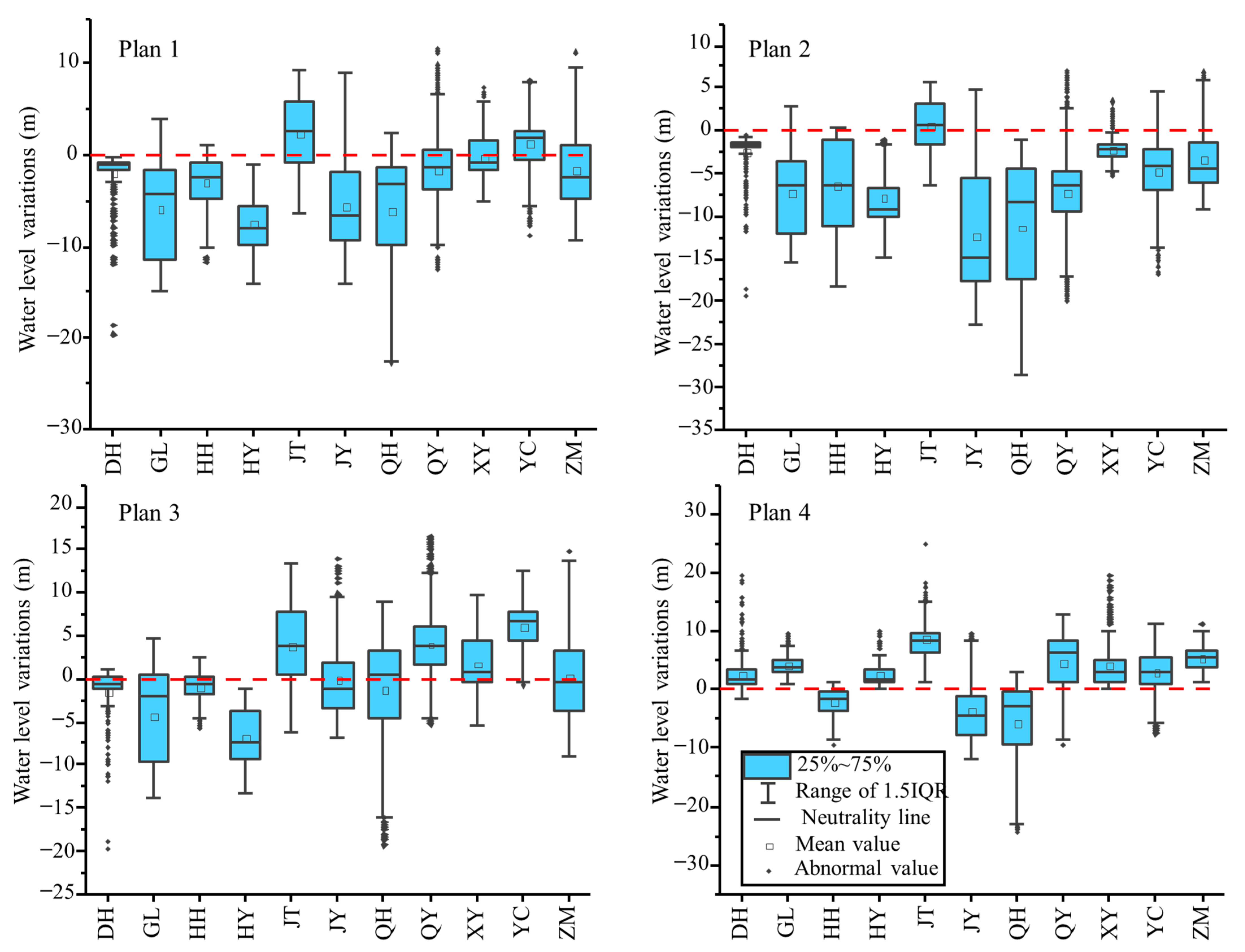
- The surface-water transfer volume has been stable in recent years. The average transfer volume was 49,216.0 × 104 m3·yr−1 in the past five years. When formulating the plans, the volume of surface water transferred was assumed to be stable from 2020 to 2050. Plan 1: maintain the current groundwater exploitation in each irrigated area. Plan 2: the groundwater exploitation should be 80% of the current situation in each irrigated area. Plan 3: the groundwater exploitation should be 60% of the current situation in each irrigated area (Table 2).
- Plan 4: the amount of water saved was 1.5 × 10⁴ m3·km−2·yr−1 to ensure food security and economic stability, according to the average level of farmland water saving in the basin in the last five years. The average irrigation water per square kilometer was reduced from the current 69 × 104 m3·km−2 to around 60 × 104 m3·km−2 by 2025. Saving water during farmland irrigation means reducing groundwater exploitation. The current average irrigation water applied per square kilometer is 55.2 × 10⁴ m3·km−2 in China. Considering the arid climate conditions in northwestern China, the irrigation quota was maintained at 60 × 104 m3·km−2·yr−1 from 2025 to 2035 to stabilize the grain output. From 2030 to 2035, according to the planned project to transfer water from the Datong River to the Qinwangchuan Basin, the surface-water allocation of the Wuwei Basin was 8300 × 104 m3·yr−1 (including 3400 × 104 m3·yr−1 in the Liangzhou District and 4900 × 104 m3·yr−1 in Gulang County). After the surface water completely displaced the groundwater in the Gulang irrigated area, the remaining water could be transported to the Qingyuan irrigated area where serious overexploitation exists downstream. The groundwater exploitation was reduced by 3400 × 104 m3·yr−1. The groundwater exploitation in other irrigated areas was maintained at the level in 2030 to prevent the groundwater exploitation in the irrigated areas from falling below the recoverable amount and to prevent the groundwater level in the northern urban area of Wuwei from being too high. After 2035, the water allocation in the Wuwei Basin, based on the planned project to transfer water from the Datong River to the Qinwangchuan Basin, was increased to 2.07 × 10⁸ m3·yr−1. The remaining surface water could be used for industry or ecology or transferred to the Minqin Basin downstream (Table 3).
3.4. Plan Comparison

4. Conclusions and Prospects
Author Contributions
Funding
Institutional Review Board Statement
Informed Consent Statement
Data Availability Statement
Acknowledgments
Conflicts of Interest
References
- Gleeson, T.; Cuthbert, M.; Ferguson, G.; Perrone, D. Global Groundwater Sustainability, Resources, and Systems in the Anthropocene. Annu. Rev. Earth Planet. Sci. 2020, 48, 431–463. [Google Scholar] [CrossRef]
- Grönwall, J.; Danert, K. Regarding Groundwater and Drinking Water Access through A Human Rights Lens: Self-Supply as a Norm. Water 2020, 12, 419. [Google Scholar] [CrossRef]
- UNESCO. World’s Groundwater Resources Are Suffering from Poor Governance; UNESCO Publishing: Paris, France, 2012. [Google Scholar]
- Siebert, S.; Burke, J.; Faures, J.M.; Frenken, K.; Hoogeveen, J.; Döll, P.; Portmann, F.T. Groundwater use for irrigation—A global inventory. Hydrol. Earth Syst. Sci. 2010, 14, 1863–1880. [Google Scholar] [CrossRef]
- Giordano, M. Global groundwater? Issues and solutions. Annu. Rev. Environ. Resour. 2009, 34, 153–178. [Google Scholar] [CrossRef]
- Giordano, M.; Villholth, K.G. The Agricultural Groundwater Revolution: Opportunities and Threats to Development; CABI: Wallingford, UK, 2007; Volume 3. [Google Scholar]
- Wang, H.; Chen, M.; Qin, D. Study on Rational Allocation and Carrying Capacity of Water Resources in Northwest China; The Yellow River Water Conservancy Press: Zhengzhou, China, 2003. [Google Scholar]
- Wang, P.; Zhang, F.E.; Chen, Z. Characterization of recharge processes and groundwater flow paths using isotopes in the arid Santanghu basin, Northwest China. Hydrogeol. J. 2020, 28, 1037–1051. [Google Scholar] [CrossRef]
- Shiyang River Basin Management Bureau. Research and Practice of Water Resources Development and Utilization in Shiyang River Basin; Shiyang River Basin Management Bureau: Wuwei, China, 2015. [Google Scholar]
- Li, F.; Chen, H.; Wang, K.; Chen, X. Comprehensive review of groundwater-dependent ecosystems. Adv. Earth Sci. 2018, 29, 750–758. (In Chinese) [Google Scholar] [CrossRef]
- Hu, H.; Ding, H.; He, B. Dynamic variation of groundwater level in the middle lower reaches of Shiyanghe River Basin for nearly 40 years. Northwestern Geol. 2016, 49, 164–174. (In Chinese) [Google Scholar]
- Feng, Q.; Li, Z.; Gao, Q.; Si, J. Ecosystem water needs and ecosystem rehalibitation of Minqin oasis in Shiyang River Basin. Adv. Earth Sci. 2012, 27, 806–814. (In Chinese) [Google Scholar]
- Ji, X.; Kang, E.; Chen, R.; Zhao, W.; Zhang, Z.; Jin, B. The impact of the development of water resources on environment in arid inland river basins of Hexi region, Northwestern China. Environ. Geol. 2006, 50, 793–801. [Google Scholar] [CrossRef]
- Cui, H.; Zhang, G.; Wang, Q.; Wang, J.; Liu, M.; Yan, M. Study on Index of Groundwater Ecological Function Crisis Classification and Early Warning in Northwest China. Water 2022, 14, 1911. [Google Scholar] [CrossRef]
- Zhu, G.F.; Su, Y.H.; Feng, Q. The hydrochemical characteristics and evolution of groundwater and surface water in the Heihe River Basin, northwest China. Hydrogeol. J. 2008, 16, 167–182. [Google Scholar] [CrossRef]
- Feng, S.; Huo, Z.; Kang, S.; Tang, Z.; Wang, F. Groundwater simulation using a numerical model under different water resources management scenarios in an arid region of China. Environ. Earth Sci. 2011, 62, 961–971. [Google Scholar] [CrossRef]
- Qi, X.; Huang, Z.; Qiao, D.; Zhang, X.; Li, P.; Mathias, N.A. Research advances on the reasonable water resources allocation in irrigation district. Adv. Earth Sci. 2015, 26, 287–295. (In Chinese) [Google Scholar]
- Gu, J.; Li, M.; Guo, P.; Huang, G. Risk Assessment for Ecological Planning of Arid Inland River Basins Under Hydrological and Management Uncertainties. Water Resour. Manag. 2016, 30, 1415–1431. [Google Scholar] [CrossRef]
- Zhang, J.; Zhang, Y.; Pu, R.; Chen, R.; Cheng, Z.; Wang, M. Safety analysis of water resources and eco-environment in Shiyang River Basin. Chin. Geogr. Sci. 2005, 15, 238–244. [Google Scholar] [CrossRef]
- Zhu, X.; Wu, J.; Nie, H.; Guo, F.; Wu, J.; Chen, K.; Liao, P.; Xu, H.; Zeng, X. Quantitative assessment of the impact of an inter-basin surface-water transfer project on the groundwater flow and groundwater-dependent eco-environment in an oasis in arid northwestern China. Hydrogeol. J. 2018, 26, 1475–1485. [Google Scholar] [CrossRef]
- Wang, Z.; Yang, J.; Deng, X.; Lan, X. Optimal Water Resources Allocation under the Constraint of Land Use in the Heihe River Basin of China. Sustainability 2015, 7, 1558–1575. [Google Scholar] [CrossRef]
- Nel, J.B.; Mativenga, P.T.; Marnewick, A.L. A Framework to Support the Selection of an Appropriate Water Allocation Planning and Decision Support Scheme. Water 2022, 14, 1854. [Google Scholar] [CrossRef]
- Yan, D.; Wang, H.; Yang, S.; Liu, M.; Huo, Z. Some opinions on the eco-hydrological processes simulation and regulation in arid basin. Adv. Earth Sci. 2008, 23, 773–778. (In Chinese) [Google Scholar]
- Su, X.; Kang, S.; Shi, P. Reasonable water resources deployment model considering the demand of ecosystem in arid area. J. Hydraul. Eng. 2008, 39, 1111–1117. (In Chinese) [Google Scholar]
- Wang, H.; Qin, D.; Guo, M.; Wang, J. Mode and calculation method for rational water resources allocation in arid zone. Adv. Earth Sci. 2004, 15, 689–694. (In Chinese) [Google Scholar]
- Xie, X.; Zhao, W.; Pei, Y. Study on Optimal Allocation and Sustainable Utilization Strategy of Water Resources in Ningxia; The Yellow River Water Conservancy Press: Zhengzhou, China, 2002. [Google Scholar]
- Chen, H.; Wang, Q.; Li, X.; Wang, Z.; Li, C. Optimal water resources planning based on interval-parameter two-stage robust stochastic programming model. Trans. Chin. Soc. Agric. Mach. 2019, 50, 10. (In Chinese) [Google Scholar]
- Liu, H.; Zhao, Y.; Li, H.; Wang, L.; Chang, H.; Peng, P. Optimal water resources allocation based on interval two-stage stochastic programming in Beijing. South North Water Transf. Water Sci. Technol. 2020, 18, 34–41. (In Chinese) [Google Scholar] [CrossRef]
- Zhao, D.; Shao, D.; Liu, B. Method of disposition on water resources of irrigation district and its applications. Trans. Chin. Soc. Agric. Eng. 2004, 20, 5. (In Chinese) [Google Scholar]
- Zhao, Z.; Hou, G.; Wang, D.; Tao, Z.; Li, Y. Characters of groundwater flow system-taking cretaceous groundwater basin as example. Ground Water 2007, 29, 14–16. (In Chinese) [Google Scholar]
- Su, X.; Song, Y.; Liu, J.; Dang, Y.; Tian, Z. Spatiotemporal optimize allocation of water resources coupling groundwater simulation model in canal-well irrigation district. Trans. Chin. Soc. Agric. Eng. 2016, 32, 9. (In Chinese) [Google Scholar]
- Cheng, X.; Jin, X.; Liu, W. Study on functions and rational allocation of Shule River basin groundwater resources. J. Groundw. Sci. Eng. 2017, 5, 140–151. [Google Scholar]
- César, E.; Wildemeersch, S.; Orban, P.; Carrière, S.; Brouyère, S.; Dassargues, A. Simulation of spatial and temporal trends in nitrate concentrations at the regional scale in the Upper Dyle basin, Belgium. Hydrogeol. J. 2014, 22, 1087–1100. [Google Scholar] [CrossRef]
- Dai, F.; Cai, H.; Liu, X. Analysis of suitable irrigation water ratio of well to channel based on groundwater model. Trans. Chin. Soc. Agric. Eng. 2012, 15, 45–51. (In Chinese) [Google Scholar]
- Safavi, H.R.; Darzi, F.; Mariño, M.A. Simulation-optimization modeling of conjunctive use of surface water and groundwater. Water Resour. Manag. 2010, 10, 1965–1988. [Google Scholar] [CrossRef]
- Lu, H.; Xie, X.; Guo, K.; Wang, J. Study on exploitable quantity of groundwater based on water resources optimal allocation. J. Hydraul. Eng. 2013, 44, 1182–1188. (In Chinese) [Google Scholar]
- Bejranonda, W.; Koch, M.; Koontanakulvong, S. Surface water and groundwater dynamic interaction models as guiding tools for optimal conjunctive water use policies in the central plain of Thailand. Environ. Earth Sci. 2013, 70, 2079–2086. [Google Scholar] [CrossRef]
- Ding, H.; Zhang, H.; Wei, Y. Report of Groundwater Exploration in Hexi Corridor; Gansu Geological Survey of China: Lanzhou, China, 2003. [Google Scholar]
- Chen, C. Water resource in Qilian Mountainous region and its influence on eco-environment of Hexi Corridor. Chin. Geogr. Sci. 1996, 6, 247–258. [Google Scholar] [CrossRef]
- Yi, L.; Xu, H. Groundwater Numerical Simulation: GMS Application Foundation and Example; Chemical Industry Press: Beijing, China, 2009. [Google Scholar]
- Meteorological Data, China Meteorological Administration. Available online: https://www.cma.gov.cn/ (accessed on 1 December 2019).
- Li, W. The underground run-off mould of the plain area in the Shiyanghe River valley. J. Hebei Coll. Geol. 1990, 013, 121–126. [Google Scholar] [CrossRef]
- Wang, J.; Zhang, G.; Cui, H.; Wang, Q.; Dong, H.; Hao, J. System index attribute and application of groundwater function zoning in northwest inland area of China. J. Hydraul. Eng. 2020, 51, 796–804. (In Chinese) [Google Scholar] [CrossRef]
- Cappucci, S.; de Cassan, M.; Grillini, M.; Proposito, M.; Screpanti, A. Multi-source water characterisation for water supply and management strategies on a small Mediterranean island. Hydrogeol. J. 2020, 28, 1155–1171. [Google Scholar] [CrossRef]
- Li, F.; Wang, Y.; Zhao, Y.; Qiao, J. Modelling the response of vegetation restoration to changes in groundwater level, based on ecologically suitable groundwater depth. Hydrogeol. J. 2018, 26, 2189–2204. [Google Scholar] [CrossRef]
- Wang, W.; Yang, Z.; Cheng, D.; Wang, W.; Yang, H. Methods of ecology-oriented groundwater resource assessment in arid and semi-arid area. J. Jilin Univ. Earth Sci. Ed. 2011, 41, 159–167. (In Chinese) [Google Scholar]
- Harvey, J.W.; McCormick, P.V. Groundwater’s significance to changing hydrology, water chemistry, and biological communities of a floodplain ecosystem, Everglades, South Florida, USA. Hydrogeol. J. 2009, 17, 185–201. [Google Scholar] [CrossRef]
- Yang, Z.Y.; Wang, W.K.; Wang, Z.; Jiang, G.H.; Li, W.L. Ecology-oriented groundwater resource assessment in the Tuwei River watershed, Shaanxi Province, China. Hydrogeol. J. 2016, 24, 1939–1952. [Google Scholar] [CrossRef]
- Liu, M.; Nie, Z.; Cao, L. Comprehensive evaluation on the ecological function of groundwater in the Shiyang River watershed. J. Groundw. Sci. Eng. 2021, 4, 326–340. [Google Scholar]
- Cao, L.; Nie, Z.; Liu, M.; Lu, H.; Wang, L. Changes in natural vegetation growth and groundwater depth and their relationship in the Minqin oasis in the Shiyang River Basin. Hydrogeol. Eng. Geol. 2020, 47, 25–33. (In Chinese) [Google Scholar] [CrossRef]
- Cao, L.; Nie, Z.; Liu, M.; Wang, L.; Wang, J.; Wang, Q. The ecological relationship of groundwater–soil–vegetation in the Oasis–Desert transition zone of the Shiyang River Basin. Water 2021, 13, 1642. [Google Scholar] [CrossRef]

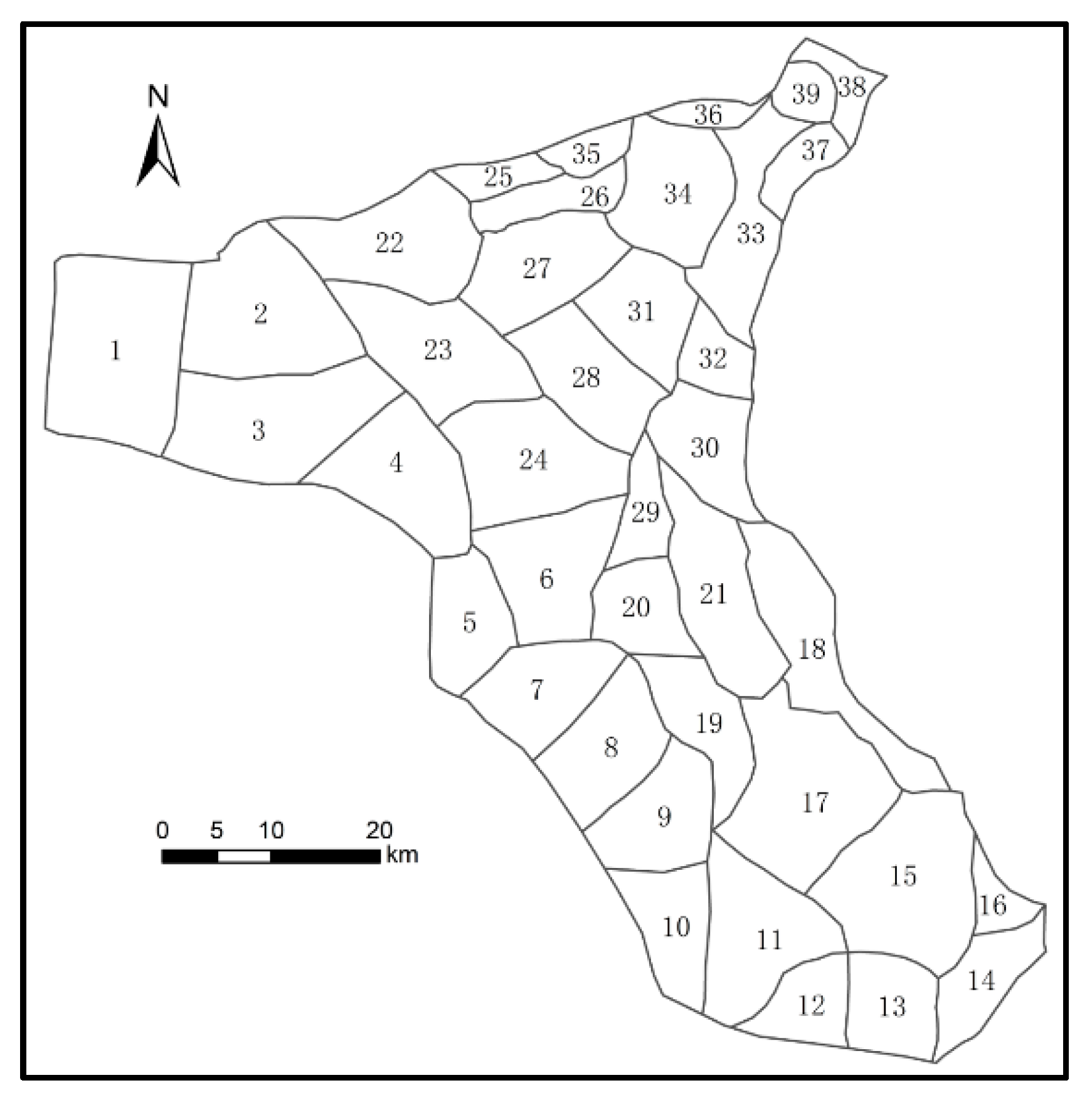
| Zone | K (m·d−1) | μ | Zone | K (m·d−1) | μ | Zone | K (m·d−1) | μ |
|---|---|---|---|---|---|---|---|---|
| 1 | 20 | 0.18 | 14 | 6.5 | 0.2 | 27 | 9.8 | 0.12 |
| 2 | 14 | 0.18 | 15 | 7.6 | 0.12 | 28 | 15 | 0.1 |
| 3 | 12 | 0.18 | 16 | 6.3 | 0.2 | 29 | 18 | 0.12 |
| 4 | 22 | 0.2 | 17 | 10.5 | 0.1 | 30 | 12.4 | 0.14 |
| 5 | 6 | 0.16 | 18 | 6.5 | 0.12 | 31 | 8.5 | 0.15 |
| 6 | 14 | 0.08 | 19 | 6.1 | 0.12 | 32 | 6.5 | 0.14 |
| 7 | 19 | 0.15 | 20 | 4 | 0.12 | 33 | 9.2 | 0.15 |
| 8 | 10 | 0.15 | 21 | 10.7 | 0.15 | 34 | 3.2 | 0.12 |
| 9 | 21 | 0.15 | 22 | 7.8 | 0.15 | 35 | 5.5 | 0.13 |
| 10 | 15 | 0.15 | 23 | 11.5 | 0.12 | 36 | 4 | 0.15 |
| 11 | 12 | 0.1 | 24 | 20 | 0.1 | 37 | 4 | 0.12 |
| 12 | 13 | 0.14 | 25 | 6 | 0.19 | 38 | 7.2 | 0.1 |
| 13 | 8.5 | 0.14 | 26 | 8.4 | 0.12 | 39 | 3 | 0.15 |
| Irrigated Area | Surface Water | Plan 1 (Datum Year) | Plan 2 (80%) | Plan 3 (60%) | |||
|---|---|---|---|---|---|---|---|
| Groundwater | Total | Groundwater | Total | Groundwater | Total | ||
| Donghe | 7903.8 | 606.0 | 8509.8 | 484.8 | 8388.6 | 363.6 | 8267.4 |
| Gulang | 3106.1 | 599.8 | 3705.9 | 479.8 | 3585.9 | 359.9 | 3466.0 |
| Huanhe | 0.0 | 1848.1 | 1848.1 | 1478.5 | 1478.5 | 1108.8 | 1108.8 |
| Huangyang | 8707.0 | 1343.3 | 10,050.3 | 1074.7 | 9781.7 | 806.0 | 9513.0 |
| Jinta | 5710.2 | 624.5 | 6334.7 | 499.6 | 6209.8 | 374.7 | 6084.9 |
| Jinyang | 0.0 | 7508.0 | 7508.0 | 6006.4 | 6006.4 | 4504.8 | 4504.8 |
| Qinghe | 0.0 | 11,671.7 | 11,671.7 | 9337.3 | 9337.3 | 7003.0 | 7003.0 |
| Qingyuan | 0.0 | 9298.1 | 9298.1 | 7438.4 | 7438.4 | 5578.8 | 5578.8 |
| Xiying | 12,087.2 | 581.7 | 12,669.0 | 465.4 | 12,552.6 | 349.0 | 12,436.3 |
| Yongchang | 0.0 | 8700.5 | 8700.5 | 6960.4 | 6960.4 | 5220.3 | 5220.3 |
| Zamu | 11,701.7 | 16,56.7 | 13,358.4 | 13,25.3 | 13,027.0 | 994.0 | 12,695.7 |
| Whole | 49,216.0 | 44,438.3 | 93,654.3 | 35,550.7 | 84,766.7 | 26,663.0 | 75,879.0 |
| Irrigated Area | 2020 | 2021 | 2022 | 2023 | 2024 | 2025 | 2026–2030 | 2031–2050 | |
|---|---|---|---|---|---|---|---|---|---|
| Donghe | Groundwater | 216.0 | 0.0 | 0.0 | 0.0 | 0.0 | 0.0 | 0.0 | 0.0 |
| Surface water | 8353.3 | 8295.8 | 8113.5 | 7931.1 | 7748.8 | 7566.5 | 7566.5 | 7566.5 | |
| Gulang | Groundwater | 911.2 | 807.1 | 737.6 | 668.2 | 598.8 | 529.4 | 529.4 | 0.0 |
| Surface water | 2351.2 | 2351.2 | 2351.2 | 2351.2 | 2351.2 | 2351.2 | 2351.2 | 2880.6 | |
| Huanhe | Groundwater | 1810.7 | 1810.7 | 1810.7 | 1810.7 | 1810.7 | 1810.7 | 1810.7 | 1810.7 |
| Surface water | 0.0 | 0.0 | 0.0 | 0.0 | 0.0 | 0.0 | 0.0 | 0.0 | |
| Huangyang | Groundwater | 115.4 | 0.0 | 0.0 | 0.0 | 0.0 | 0.0 | 0.0 | 0.0 |
| Surface water | 8631.1 | 8467.3 | 8281.2 | 8095.1 | 7909.0 | 7722.9 | 7722.9 | 7722.9 | |
| Jinta | Groundwater | 1435.7 | 1214.8 | 1067.6 | 920.3 | 773.1 | 625.8 | 625.8 | 625.8 |
| Surface water | 5484.8 | 5484.8 | 5484.8 | 5484.8 | 5484.8 | 5484.8 | 5484.8 | 5484.8 | |
| Jinyang | Groundwater | 4746.4 | 4594.9 | 4493.9 | 4392.9 | 4291.9 | 4190.9 | 4190.9 | 4190.9 |
| Surface water | 0.0 | 0.0 | 0.0 | 0.0 | 0.0 | 0.0 | 0.0 | 0.0 | |
| Qinghe | Groundwater | 11,106.9 | 10,752.4 | 10,516.1 | 10,279.8 | 10,043.5 | 9807.2 | 9807.2 | 9807.2 |
| Surface water | 0.0 | 0.0 | 0.0 | 0.0 | 0.0 | 0.0 | 0.0 | 0.0 | |
| Qingyuan | Groundwater | 10,050.2 | 9729.5 | 9515.6 | 9301.8 | 9088.0 | 8874.1 | 8874.1 | 5474.1 |
| Surface water | 0.0 | 0.0 | 0.0 | 0.0 | 0.0 | 0.0 | 0.0 | 3400.0 | |
| Xiying | Groundwater | 2319.5 | 1859.1 | 1552.1 | 1245.2 | 938.3 | 631.3 | 631.3 | 631.3 |
| Surface water | 12,106.4 | 12,106.4 | 12,106.4 | 12,106.4 | 12,106.4 | 12,106.4 | 12,106.4 | 12,106.4 | |
| Yongchang | Groundwater | 7561.1 | 7319.8 | 7158.9 | 6998.1 | 6837.2 | 6676.3 | 6676.3 | 6676.3 |
| Surface water | 0.0 | 0.0 | 0.0 | 0.0 | 0.0 | 0.0 | 0.0 | 0.0 | |
| Zamu | Groundwater | 2514.8 | 2062.0 | 1760.1 | 1458.2 | 1156.3 | 854.4 | 854.4 | 854.4 |
| Surface water | 11,673.5 | 11,673.5 | 11,673.5 | 11,673.5 | 11,673.5 | 11,673.5 | 11,673.5 | 11,673.5 | |
| Whole | 91,387.9 | 88,529.1 | 86,623.2 | 84,717.3 | 82,811.4 | 80,905.5 | 80,905.5 | 80,905.5 | |
| Irrigated Area | DH | GL | HH | HY | JT | JY | QH | QY | XY | YC | ZM | |
|---|---|---|---|---|---|---|---|---|---|---|---|---|
| Groundwater Depth in 2018 | 234.2 | 139.5 | 7.9 | 174.1 | 75.0 | 15.0 | 39.2 | 37.5 | 96.4 | 14.9 | 75.7 | |
| Groundwater level variations to 2050 | Plan 1 | −2.5 | −7.2 | −6.4 | −7.9 | 0.6 | −12.3 | −11.3 | −7.2 | −2.2 | −4.7 | −3.4 |
| Plan 2 | −1.9 | −5.9 | −3.0 | −7.4 | 2.5 | −5.7 | −6.0 | −1.6 | −0.2 | 1.3 | −1.6 | |
| Plan 3 | −1.4 | −4.3 | −1.0 | −6.7 | 3.7 | −0.1 | −1.2 | 4.0 | 1.7 | 6.0 | 0.3 | |
| Plan 4 | 2.7 | 4.1 | −2.2 | 2.4 | 8.6 | −3.8 | −5.7 | 4.7 | 4.1 | 2.9 | 5.3 | |
 9 m.
9 m.Disclaimer/Publisher’s Note: The statements, opinions and data contained in all publications are solely those of the individual author(s) and contributor(s) and not of MDPI and/or the editor(s). MDPI and/or the editor(s) disclaim responsibility for any injury to people or property resulting from any ideas, methods, instructions or products referred to in the content. |
© 2022 by the authors. Licensee MDPI, Basel, Switzerland. This article is an open access article distributed under the terms and conditions of the Creative Commons Attribution (CC BY) license (https://creativecommons.org/licenses/by/4.0/).
Share and Cite
Wang, L.; Nie, Z.; Liu, M.; Cao, L.; Zhu, P.; Yuan, Q. Rational Allocation of Water Resources in the Arid Area of Northwestern China Based on Numerical Simulations. Sustainability 2023, 15, 55. https://doi.org/10.3390/su15010055
Wang L, Nie Z, Liu M, Cao L, Zhu P, Yuan Q. Rational Allocation of Water Resources in the Arid Area of Northwestern China Based on Numerical Simulations. Sustainability. 2023; 15(1):55. https://doi.org/10.3390/su15010055
Chicago/Turabian StyleWang, Lifang, Zhenlong Nie, Min Liu, Le Cao, Pucheng Zhu, and Qinlong Yuan. 2023. "Rational Allocation of Water Resources in the Arid Area of Northwestern China Based on Numerical Simulations" Sustainability 15, no. 1: 55. https://doi.org/10.3390/su15010055
APA StyleWang, L., Nie, Z., Liu, M., Cao, L., Zhu, P., & Yuan, Q. (2023). Rational Allocation of Water Resources in the Arid Area of Northwestern China Based on Numerical Simulations. Sustainability, 15(1), 55. https://doi.org/10.3390/su15010055


