1. Introduction
The high frequency of earthquakes in Mexico City is due to the fact that the country is located on the limit of the North American plate, which creates a subduction zone with the Cocos plate in the Pacific Ocean. It is also part of the Pacific Ring of Fire and forms spreading zones at the boundaries of the North American and Pacific plates [
1]. In the last 50 years, two earthquakes have marked Mexican society, both with devastating material consequences, in 1985 and 2017, both on 19 September, in a gloomy way. The earthquakes were of a similar magnitude (8.1 on the Richter scale). However, the number of deaths was diametrically different; in 1985 it was estimated at around 50,000 deaths, while in 2017, it was only 370 [
2]. This is because the way humans react and prepare for an emergency is no longer the same. Education on civil protection is part of cross-cutting and civic education at all levels of education in Mexico City. This education consists of having training sessions on evacuation in the event of an earthquake, use of evacuation nomenclature, identification of risk areas and safe areas, meeting points, and formation of committees in charge of some particular action for the correct response to large-scale events. In fact, progress in the Information and Communication Technologies (ICT) have produced multiple tools, such as a communication system for a seismic alert system located on the Pacific coast that sounds at least 30–45 s before the seismic wave reaches Mexico City. Other examples of relevant tools during the 2017 earthquake were the use of the WhatsApp instant messaging platform or the city evacuation systems [
3,
4].
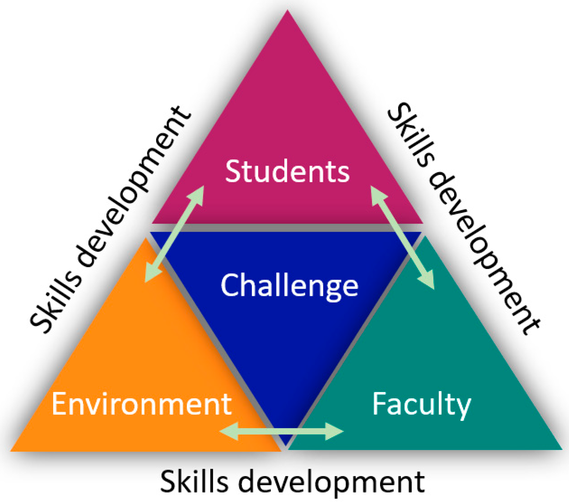
In emergency situations, it is essential to have adequate alternatives to evacuate people in real or potential danger. Taking this context into account, the question that arises is: how can we address social problems through higher education? Since 2015, the Tecnologico de Monterrey has been implementing the Tec21 educational model, which is based on four fundamental pillars:
Inspiring Faculty
A comprehensive and memorable students experience
Flexibility in when and where the learning experience takes place and
Challenge-Based Learning (CBL) didactic technique for students’ competencies development.
CBL is an educational technique that engages students in current, relevant, and real-world problems so that they can propose solutions working in multidisciplinary teams, managing uncertainty, and with the focus on competency development [
5]. The focus is on how the students tackle the challenge and the process they follow to apply their knowledge and skills, research and learn new information, and propose possible solutions to the assigned problem. This process is part of the immersive learning experience and matters more than the proposed solution itself. CBL has been applied in K-12 education combined with the engineering design process to foster students’ creativity and entrepreneurship skills [
6]. Teachers have integrated engineering and CBL into their instruction for the development of decision-making competency [
7].
Tecnologico de Monterrey has had a very active role implementing CBL in its undergraduate programs. Some examples of relevant CBL experiences implementation at our university include challenges with Mechatronics and Biotechnology Engineering students, and the impact of digital technology tools on the competence development; this research suggests the use of checklists and clear rubrics for an objective and transparent evaluation process in CBL courses [
8]. A key element within the CBL experience is the educational partner, which is an entity, company, or organization from the manufacturing or service sector, civil society, or community groups, with which Tecnologico de Monterrey has built a connection for long-term collaboration and opens their doors to propose real and relevant problems to immerse students and professors in a real context, with its advantages and constraints. A successful example of this collaboration involves an automotive company and students from our Computer Science, Business and Technology, Digital Systems, and Mechatronics engineering programs to propose solutions to innovative challenges on the digital transformation journey of the company [
9]. As faculty, evaluating competencies development is a challenge by itself. Studies have shown that having adequate evaluation instruments, for instance, checklists and rubrics, promote an objective and fair assessment [
10]. When presenting the challenge to the students, it becomes relevant to clearly state the competencies to be evaluated and the performance indicators, as well as the corresponding diagnostic, formative, and summative assessment instruments that would be used during the CBL experience [
5].
Moved by the painful experiences lived at Mexico City Campus during the 2017 earthquake when a pedestrian bridge between two buildings collapsed, killing 5 students and injuring 30 others, a challenge was established to create a device that could help in the event of a disaster. Students and faculty from the Telecommunications and Electronic Systems engineering program at our university were involved in the challenge. The educational partner was the emergency response coordinators (ERCs) from the university since the device should consider the specific requirements of the campus to be integrated within the existing evacuation protocols. This proposal was designed in terms of developing a system that represents both a technology-based tool to improve evacuation times and a tool for measuring certain academic skills in the participants involved to encourage them in the development process, such as the resolution of real problems, integration of state-of-the-art technology, and social impact according to the Tec21 educational model. The hypothesis of this research work is that students can develop skills and competencies by being immersed in a real-life context, working on a relevant challenge, and having constant interaction between students, faculty, and the related stakeholders (
Figure 1).
2. Literature Review
This section does not attempt to summarize the entire scope of the literature, but rather identifies key research-related themes and provides a descriptive overview of the evidence from the last ten years (2013–2022) to contextualize the decisions made in designing this research. In particular, the literature available until 2022 was carefully studied to show the relevance and pertinence of the use of cutting-edge technologies for the development of evacuation systems and protection against natural disasters.
The work of Vilar et al., in 2013, aimed to investigate the influence of external information presented on a lower level of consciousness during route selection. The experiment provided a means of improving interior orientation and predicting user movements within buildings. The study made it possible to evaluate the influence of environmental characteristics, such as corridor width, corridor luminosity, and corridor intersection configuration, on the selection of emergency routes that people make during interactions with an unknown environment [
11].
In 2014, Shimura and Yamamoto presented a generic multi-objective evacuation route search algorithm that solves the problem of optimizing evacuation routes in case of seismic disasters by treating it as an optimization problem with multiple objectives, such as the evacuation distance and the evacuation time. The study reported that searching for evacuation routes based on information about real-time conditions allowed them to derive updated evacuation routes based on the locations of different corridors and buildings [
12].
In 2016, Han et al. developed a method of emergency communication and rapid investigation of seismic damage based on a smartphone is proposed. For this, an application is developed on the iOS platform with an emergency communication module, so that communication is available even without an external network. The study provided an interesting solution since it is very common for communications in the area affected by an earthquake to be cut from the outside after the earthquake, which makes emergency rescue work difficult [
13]. Another important work of 2016 is that of Annadata et al., in which the design of the automation of evacuation assistance systems is studied to help in drills and in real evacuations in order to save costs, time, and human lives. The study proposed an Internet of Things (IoT)-based evacuation assistance system to improve the response to an emergency and provide the number of people in a building from their last known locations in an automated way, and even automate the reconciliation process using multiple channels, such as Wi-Fi and motion detection [
14].
A year later, in 2017, Penmetcha et al. introduced an Android-based app that used the Wi-Fi fingerprint technique to locate a person in an indoor environment with an accuracy of up to 1 m. This app could run in the background and let rescuers know the exact location of the person in distress, along with an image of the floor map via SMS [
15]. Xu et al., in their work presented in 2018, focused on the rapid and systematic evacuation of high densities of people after natural disasters, such as earthquakes and fires, to reduce losses effectively. The work included the design of a system based on an Internet of Things (IoT) scenario using a mobile cloud computing platform to develop the Crowd Life Oriented Tracking and Helping Optimization (CLOTHO) system. The application is based on an evacuation planning algorithm that uses the artificial potential field (APF), which guides the evacuees in relation to moving to the same shelter to calm the victims and perform a more humanitarian evacuation [
16].
Zualkerman et al. presented a study in 2019 on a system that uses IoT technologies to track the location of a fire and the occupants of the building, and then intelligently directs the occupants to a safe exit. The system uses Bluetooth Low Energy (BLE) beacons for indoor location using occupants’ mobile phones. The system also tracks danger areas using smoke and temperature sensors. The system uses multiple networks, including Wi-Fi and DigiMesh, to enable smart exit signs to be deployed throughout the building that dynamically change their state based on the location of the fire to guide occupants to safety [
17]. In response to this point by the expert reviewer, a new paragraph was added to the text describing very recent quotes:
In June 2021, He [
18] presented a network-based pedestrian dynamics simulation model that included a simplified probabilistic structural damage assessment and random structural vibration analysis, with the aim of creating a completely random evacuation model to simulate and analyze processes of seismic evacuation of pedestrians from multi-story buildings during earthquakes. The model simplified the simulation of three-dimensional pedestrian dynamics by coupling emergency evacuation processes and structure damage processes and considered the magnitude of seismic excitation. In the same year, Ooi et al. developed an evacuation drill system to improve the awareness of pupils or students as an evacuation drill in school education. The study highlighted the importance of disaster prevention education, especially that which uses virtual reality (VR) technology to provide correct evacuation knowledge not only to teachers and emergency coordinators, but also to visitors and students [
19].
As for the most recent literature, a comprehensive review in the Scopus database (
www.scopus.com (accessed on 30 March 2022)) in 2022, there are four articles related to the topic of building evacuation emergency assistance systems:
Sun et al. proposed algorithms that consider dynamic conditions using queuing theory and graph theory. They characterize the disaster evacuation network as a directed acyclic graph and exploit a queuing model MMPP/M/l/N to derive the optimal route in terms of minimum driving time using high-end sensors for dynamic acquisition of data. The experimental results validate the accuracy of their algorithms and compare them with the Dijkstra-based shortest-path route [
20].
Hassanpour et al. presented a novel comprehensive approach to consider the variable of human behavior in evacuation strategies and the design of the interior design of a building, focusing mainly on non-structural damage. The project included a hybrid hierarchical agent-based model (ABM) framework integrated with a cellular automaton (CA) and a 2D building information model (BIM) to consider a non-structural damage approach. The study incorporates learning mechanisms and human psychological aspects that influence the behavior of evacuees during the pedestrian evacuation process [
21].
Finally, Lorusso et al. demonstrated how to integrate a virtual reality platform with numerical simulation tools to reproduce evolving fire emergency scenarios. Although this work analyzes an emergency that is different from the main topic of the other studies in this literature review, its inclusion in this section is important, since it analyzes evacuation scenarios in real time, based on building information models. The authors use specific software to simulate, in real time, the crowd dynamics in the virtual environment during the emergency evacuation process in an existing school building [
22].
3. Background Information
Earthquakes happen unexpectedly (there is no way to predict them) and can be catastrophic in terms of material and human losses. Although this type of natural disaster cannot be avoided, it is essential to be prepared to minimize casualties and injury to people. Preparation for emergency evacuations in medium- to large-scale corporations with high-density buildings and hundreds of students, teachers, and administrative staff, must be performed according to emergency preparedness plans with evacuation procedures by conducting regular drills.
Educational institutions generally have teams of volunteer employees who are formally trained in disaster management procedures and are called emergency response coordinators (ERCs) [
23]. Generally, these teams ensure that, in the event of a disaster, at least one ERC provides coverage in each building and on each floor. The ERCs oversee protocols that broadly consists of several tasks: The first task of an ERC is to direct people to calmly leave the building and meet at a predetermined meeting point far enough from the building. Second, ERCs also ensure that the disaster is reported to the appropriate ER or emergency services as soon as possible. The third task, once at the assembly point, is the process called reconciliation, which means accounting for all the people who were in the building before the disaster [
14]. To carry out reconciliation, the ERCs must have the real-time updated attendance list on hand and bring it with them to the meeting point. Using the attendance list and the list of reconciled people prepared at the meeting point, they can produce a list of people who are still not accounted for: these persons are the ones who are supposedly trapped in the building.
How many people were in the building? The process of accounting for all the people at the meeting point is still a manual task in most cases and, therefore, error prone; even a small number of false negatives (the person erroneously counted as not trapped) can be dangerous to trapped people, and too many false positives (too many people mistakenly reported as trapped) can mean losing valuable response time. In the case of earthquakes, another problem is that centralized electronic assistance systems can go offline or become inaccessible, forcing rescuers to search from room to room. Finally, in the case of evacuations on university campuses with many buildings, multiple assembly points, multiple ERCs, and multiple exit points are also involved. The concatenation of the exposed problems results in the need to develop more complex and reliable assistance strategies.
Proposed emergency evacuation systems, some of which have been included in the Literature Review section, suggest automation through assistive systems using technologies such as RFID, NFC, etc., which provide rescuers with a baseline number of people who actually were in the building before the disaster [
13,
14,
15,
16,
17]. For registered users (e.g., employees, teachers, and students) who adhere to the check-in process (e.g., card swipe) to classrooms and offices, these systems are highly accurate. However, most assistance systems are useless in accounting for “non-swipers”, such as visitors, or even the people who come and go from the cafeteria, gym, library, learning commons, and laboratories, and those who are in transit in corridors, stairs, or toilets, where the count becomes imprecise. These inaccuracies in attendance systems cause two problems: The first problem is not having an accurate count to know precisely how many people were in the building; second, there is the problem related to the inability to automatically reconcile those not accounted for in a certain assembly point—such as visitors or those who were in transit—that is, not being able to know how many people are still not accounted for. Finally, the evacuees’ safety is affected by dynamic and changing weights of influencing factors, such as Crowding, Obstructions, Vulnerability, Danger, and Visibility [
4].
4. Proposed System
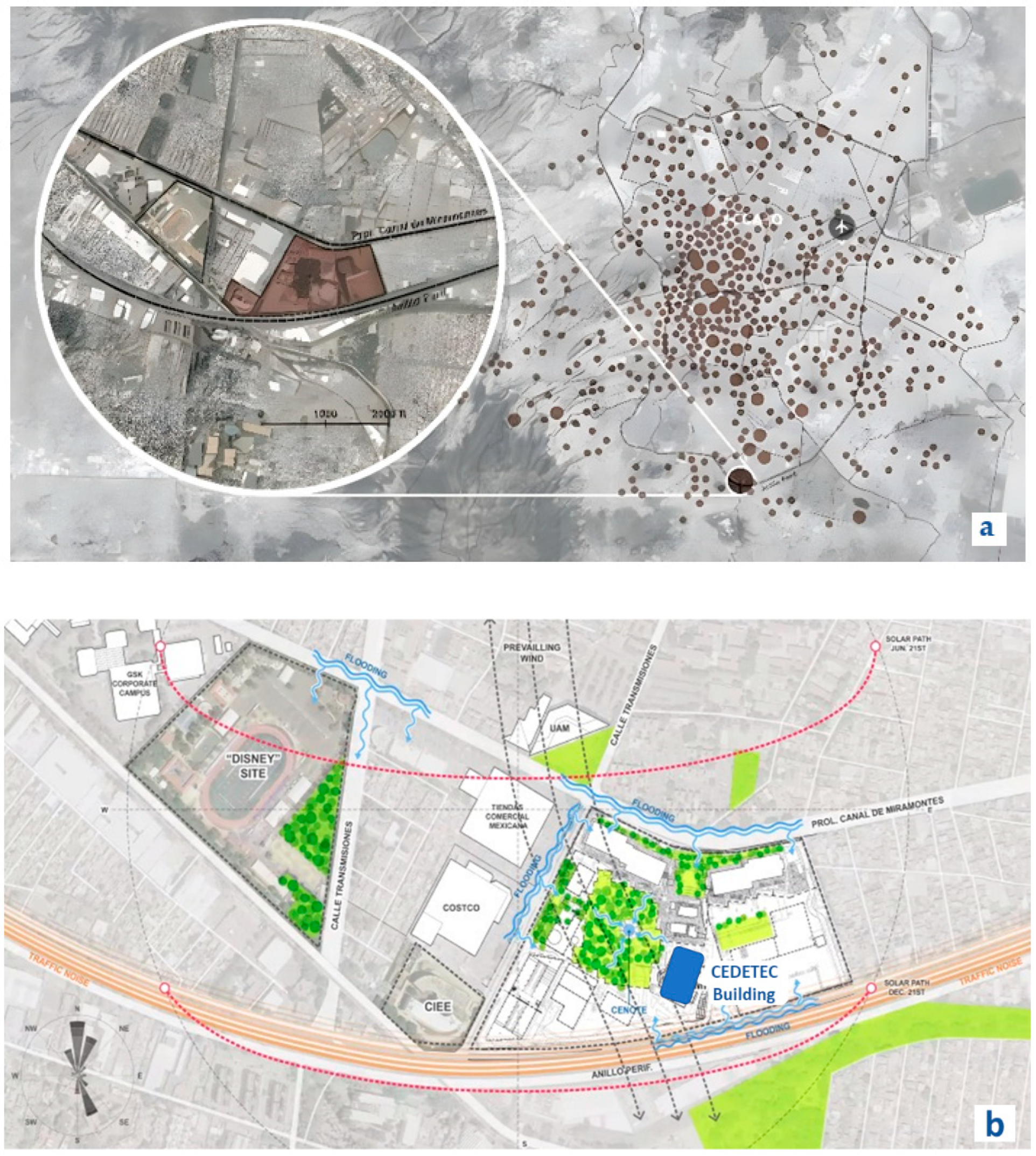
The proposed system was implemented in the Research and Development Center (CEDETEC) at Tecnologico de Monterrey, Mexico City Campus.
Figure 2 shows (a) the location of the campus within Mexico City and (b) the location of the CEDETEC building within the campus. One of the main reasons to choose this building was because, although it has trained assistance personnel and evacuation protocols, they may be insufficient in the event of a large-scale seismic emergency, such as the one experienced on 19 September 2017. In addition, intelligent evacuation systems are not yet implemented in Mexico at the industrial level, which leads to a total dependence on the protocols’ liabilities (alarms, signaling, evacuation protocols) of the institutions and the community in general.
The challenge in which the students participated was the design of an evacuation assistance system (TECuidamos) to function in the geographic and structural limitations of this building.
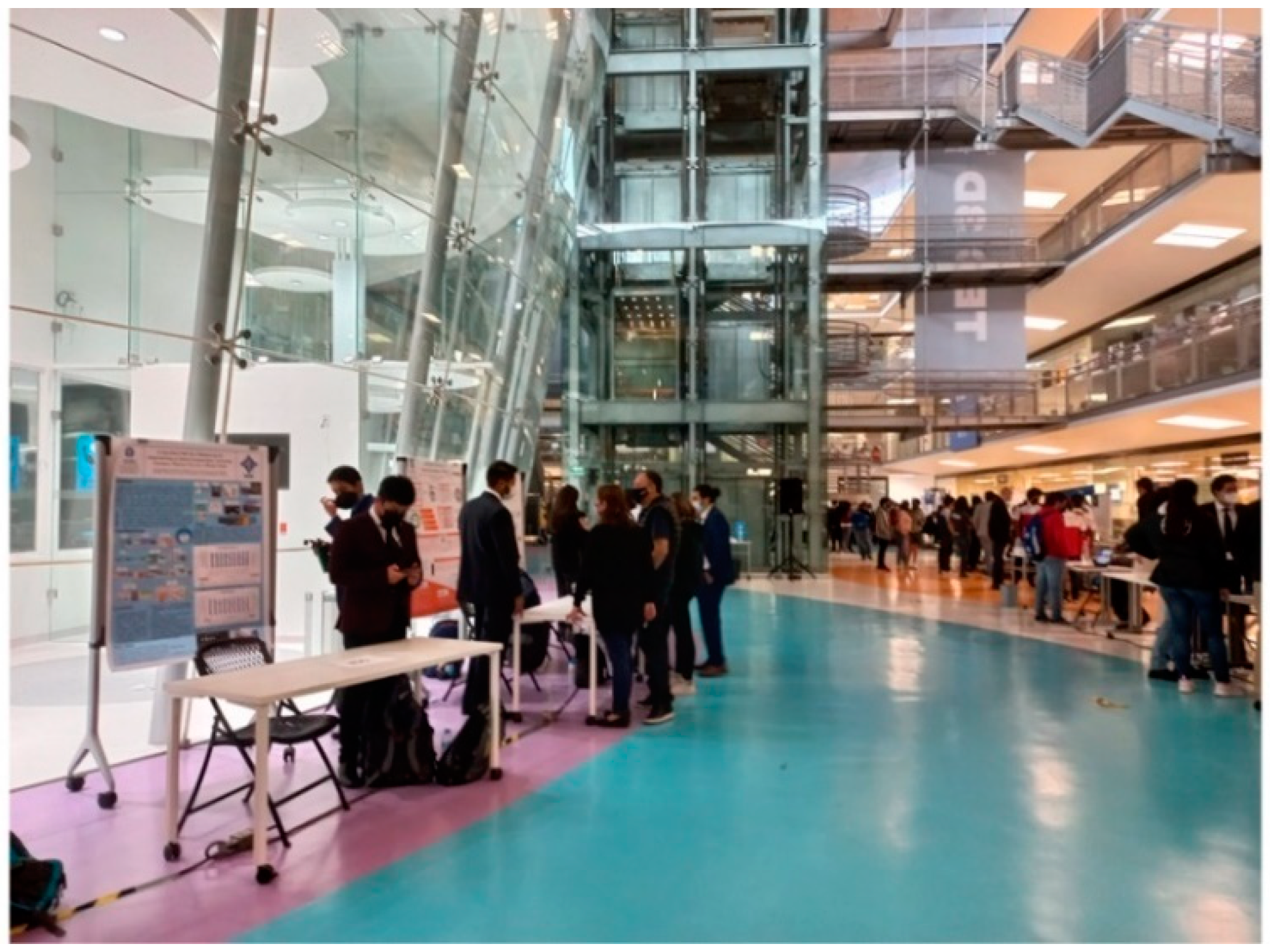
Figure 3 shows the interior of the CEDETEC building with large glass walls, floating staircases, and a multi-story high Central Exhibition Hall. It is important to mention that the current protocol in an emergency (earthquake, fire, landslide) indicates leaving the facility as quickly as possible, following the instructions of the authorities, evacuation signals, leaving in an orderly behavior, and arriving and staying in the designated safe zones. People evacuated are then manually counted and recorded by campus civil protection officers. The lack of evaluation and selection of environments and routes, the automatic evacuation by selecting the best route, and monitoring and taking the census of the population in danger are the motivation of this challenge. Senior students of the Telecommunications and Electronic Systems engineering program were immersed in the challenge to design the electronic system that could help in the event of a disaster (in the exercise, an earthquake was established like the one experienced in 2017 of 8.1 on the Richter scale). The challenge consisted of developing a system that allows people to evacuate the CEDETEC building in the shortest possible time in case of emergency.
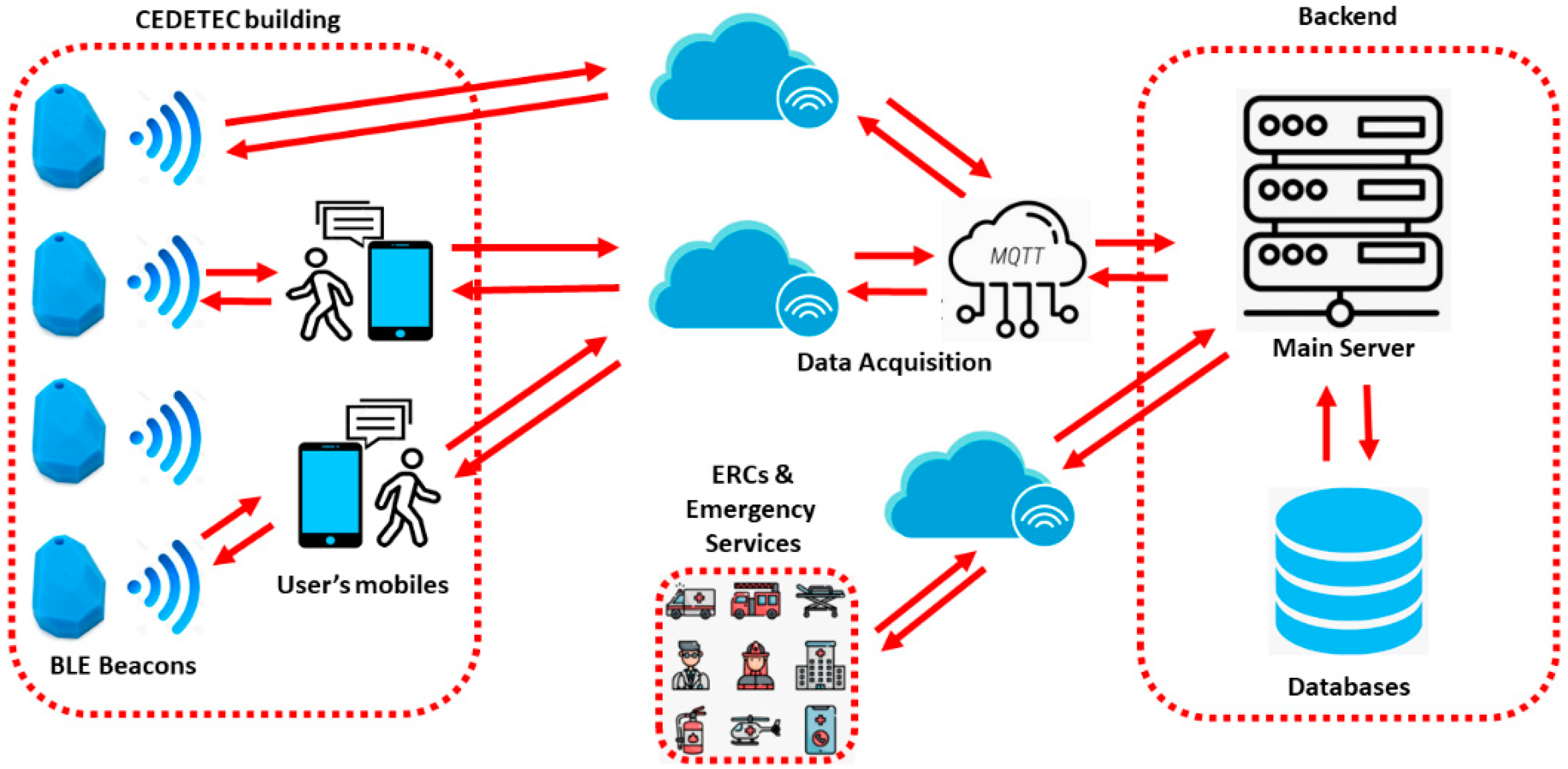
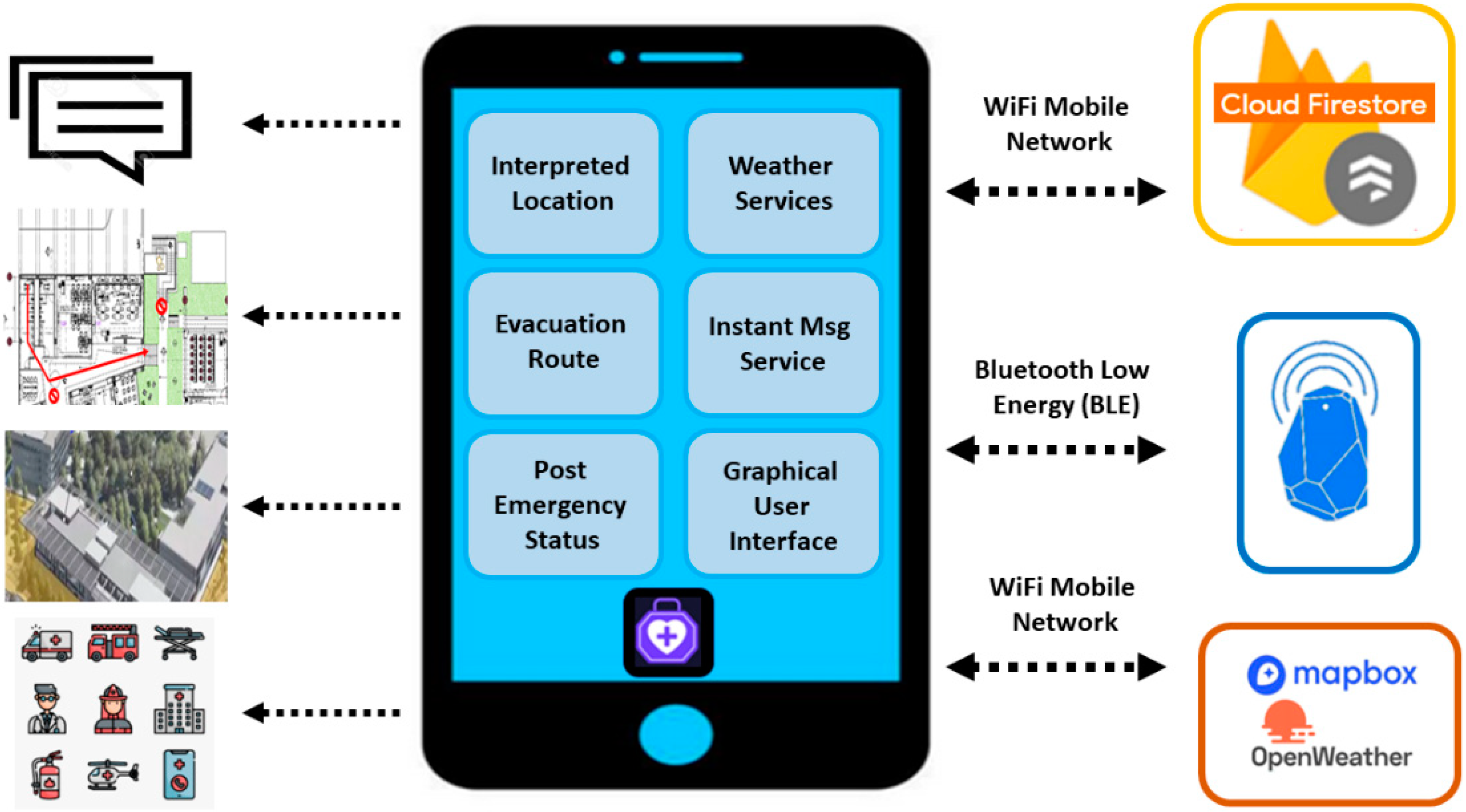
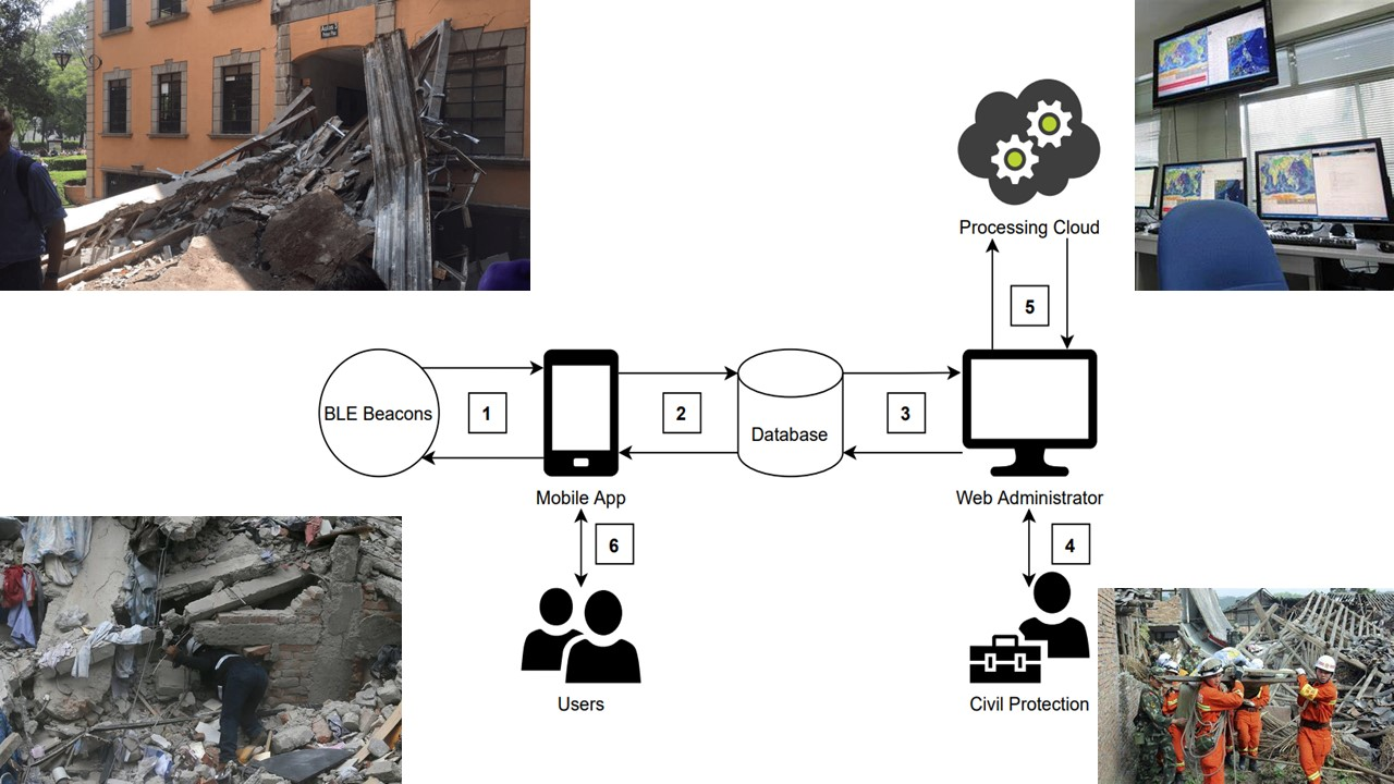
4.1. System Architecture
TECuidamos has four main modules: Data Acquisition, Wireless Transmission Network, Cloud Server, and User Access, as shown in
Figure 4.
Data Acquisition module. This is primarily responsible for collecting location information and personal information (name and email) through the smartphones of people who enter the CEDETEC building.
Wireless Transmission Network module. This allows bidirectional communications between smartphones and the Cloud Server and is based on Bluetooth Low Energy (BLE) devices known as beacons. As shown in
Figure 5, these beacons were installed at certain points of interest in rooms, corridors, and stairs to know the updated location of people inside the building, the number of users per location, the number or evacuees, so that the ERC authorities are always aware of how many people are in each spot, before and after evacuation.
Cloud Server module. This receives the data from the Data Acquisition module and provides data storage and processing services. The main tasks of the cloud services module are to manage the information of the trapped people, and through a route planning algorithm, considering the degree of risk and the weights of influencing factors, as mentioned in the previous section, determine the safest evacuation path and the spots that can serve as temporary shelter.
User Access module. This is used as an interactive interface for people to obtain the evacuation services of the Cloud Server module, including the browser-based access interface for ERCs and the visualized evacuation planning for the smartphones.
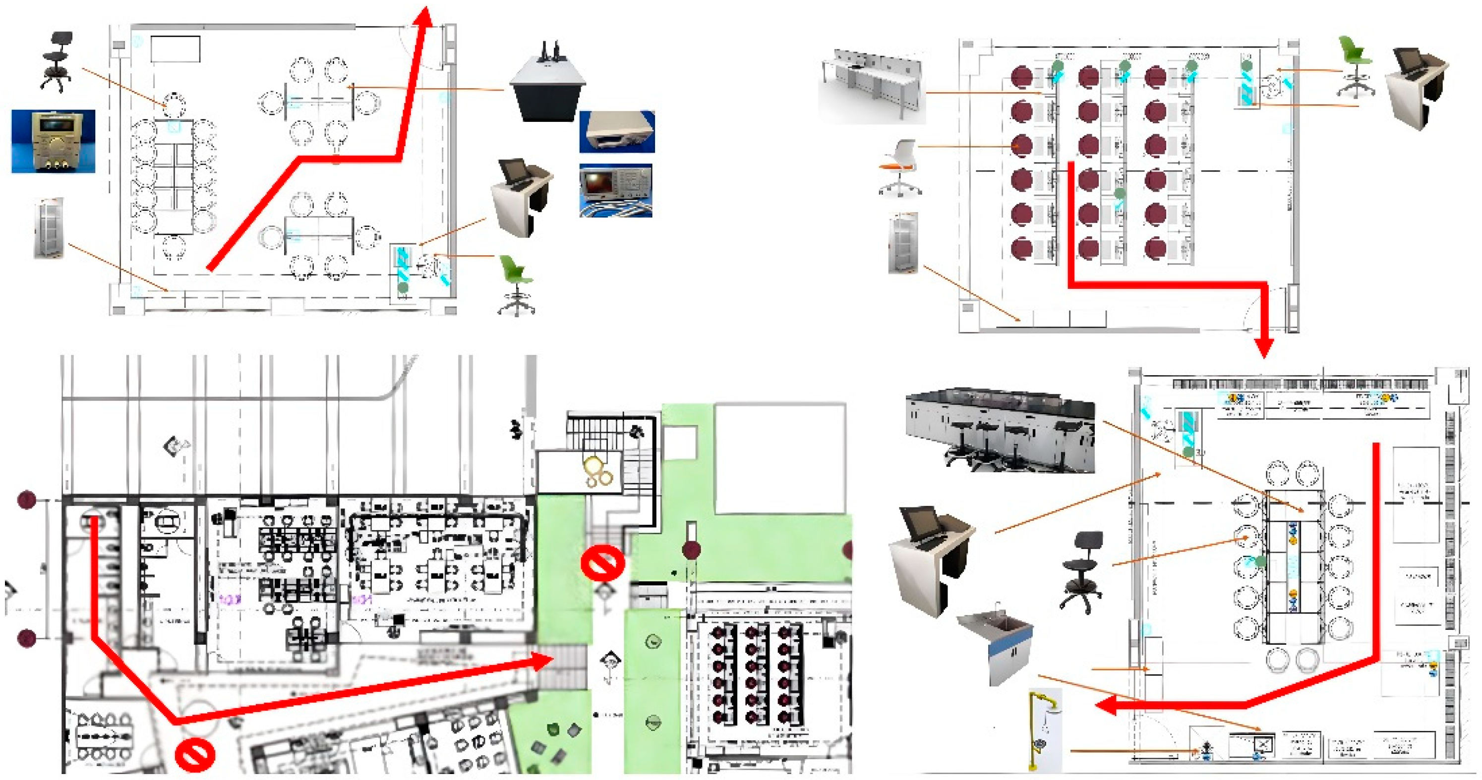
Figure 6 shows some plans of laboratories, with the type of furniture, location of the instruments, number of chairs and tables, and other data necessary to know the situation of the people trapped near each beacon. It is very important to know the exact structural characteristics, the exact location, and the amount of furniture and appliances in each room of the building for the calculation of the level of safety variables: Crowding, Obstructions, Vulnerability, Danger, and Visibility [
4], which determine the changing real-time display of the safe exit routes and the corridors/exits that should be avoided due to the risk of collapse or blockage. The safety variables considered and their levels were the following:
Crowding is related to the influence of human densities on respective escaping velocities within each classroom and laboratory of the network. The danger level can vary from pedestrian space >3.7 m2/p (with sufficient area to bypass other pedestrians and avoid crossing conflicts), to pedestrian space <0.75 m2/p (where walking speeds are severely restricted).
Obstructions are related to the possible presence of debris (from damaged walls and ceilings) along the corridors. The danger level can vary from corridors/exits without blocked sections to corridors/exits with almost one blocked section.
Vulnerability is related with the tendency of built elements along the escape path (e.g., floating staircases, monuments, glass walls, large metal shelves, and pedestrian bridges) to suffer earthquake-induced damages. The danger level can vary from Low to High.
Danger is related to effects due to fires, toxic smoke or dust, and explosions provoked by flammable liquids stored in chemical laboratories, transformer oil leaks in electrical cabinets, broken gas pipes in kitchens, etc. The danger level can vary from no threat along the corridors/exits, to mortal threat in the case of the presence of toxic smoke, widespread fires, and toxic substances leaks.
Visibility affects the individuals’ perception of the surrounding environment and can provoke a deceleration of a pedestrian’s escaping motion. The danger level can vary from absence of visibility interferences to presence of dense smoke, thick dust, and even a total blackout situation.
4.2. Mobile Application Tool
The main challenge of the CBL strategy was to integrate multiple ICT tools in a mobile application, which aims to provide personalized assistance for the location, evacuation, and help of people in an emergency. The TECuidamos application was made up of the following operating modules:
Interpreted location. The user’s location within the building is shown according to parameters established within the application and with the help of Bluetooth Low Energy (BLE) devices.
Evacuation Route. Once the emergency signal is activated, the user will be shown the ideal evacuation route for them, according to certain parameters contemplated in an algorithm.
Weather Services. Current weather and forecasts are displayed based on the user’s location.
Instant Messaging Service. Platform through which users can communicate internally, having the possibility of communicating relevant information to the community.
User survey. Tool that allows users to communicate their post-emergency status.
Figure 7 shows an overview of the mobile app’s block diagram that summarizes the features that are included in the App and the other technologies that work together to provide the information needed for the feature to work well.
5. Methodology
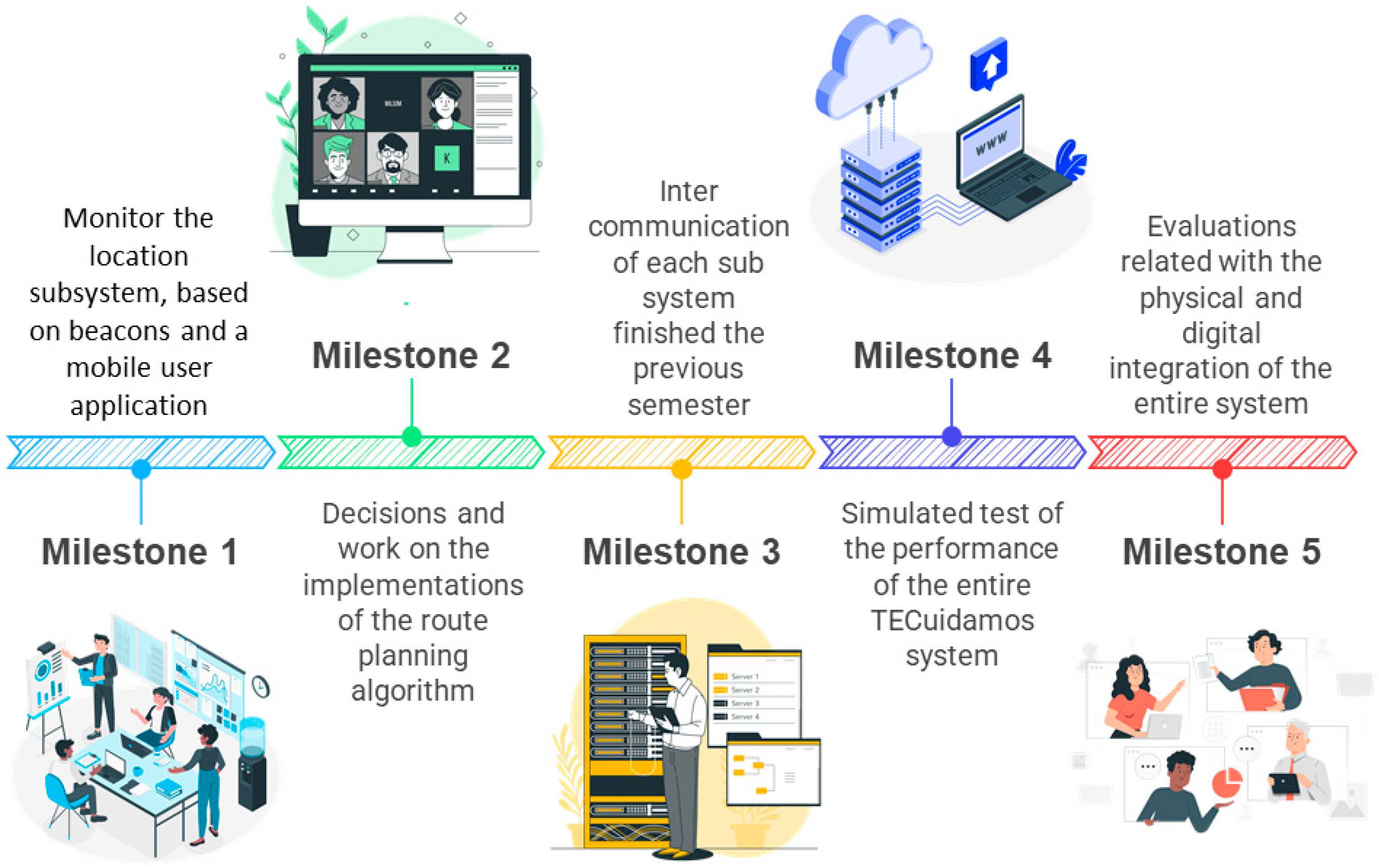
This project was developed considering the achievement of different milestones throughout the roadmap, as shown in
Figure 8. The project was divided into tasks that represented a challenge for each team. In this way, throughout the semester, milestones were reached, and the progress obtained was verified. Three teams of students were appointed to perform each partial challenge separately over a year, because it was also necessary to be aligned with the academic terms at the university.
Semester #1: Spring 2020
In this period, students were in charge of the choice and implementation of the route planning algorithm. This decision was made based on the investigation of various evacuation systems that implemented differ rent technologies, such as evaluation systems based on sensors, a central processing unit, and actuators [
4,
11]; different procedures and guidelines, such as generation of random routes [
12]; and extensive hazard evaluation routes and route planning algorithms. All these works used the Dijkstra algorithm [
24]. It was also found that most of these systems were developed considering open space circumstances.
Team #1: 6 students
Milestone #1: Oversaw the location subsystem, performed an investigation, a beacon-based implementation, and a mobile user application to locate and enable interaction between users and the entire system through sensors.
Team #2: 6 students
Milestone #2: Oversaw the evacuation subsystem, performed the research, made decisions and worked on the implementations of the route planning algorithm and cloud processing to effectively evacuate users, as well as the web administrator to manage and visualize the system data flow.
Semester #2: Fall 2021
In this period, students worked on the modifications in the route planning algorithm to adapt it to the needs of the entire system and its users (real-time location and map distribution). The deployment of a web page (Web Administrator) to manage the distribution of available routes during an emergency and function as a User Interface (UI) to monitor events after, during, and before the evacuation was also considered. This project followed a busy schedule and methodology and contributed to the students’ competences development according to the Telecommunications and Electronic Systems engineer profile [
14]. Some examples of these skills and competences are the creation of state-of-the-art electronics and technology applications; design, analysis, and implementation of telecommunications systems using computer tools and instrumentation equipment; and knowing and understanding the economic, social and political reality of the environment, acting with solidarity and responsibility to improve the quality of life in the communities.
Team #3: 6 students
Milestone #3: Integration, interconnection, and intercommunication of each of the sub-systems finished the previous semester.
Milestone #4: System Testing and Maintenance. Simulated test of the performance of the entire TECuidamos system with fictitious user data injected into the Firebase control site to test the communication and the correct flow of information from the database, the web manager, and the processing cloud.
Milestone #5: The second evaluation is a field test, always following the health protocols established by the educational institution. These two evaluations involved the physical and digital integration of the entire system, recovering the location of some real users through the beacons, and generating the relevant routes that these users can view with the mobile application.
6. Results
6.1. Results Related to the Skills Assessment
Among the student outcomes declared by ABET (Accreditation Board for Engineering and Technology), the authors find: “an ability to identify, formulate, and solve complex engineering problems by applying principles of engineering, science, and mathematics”. ABET defines a complex engineering problem when it includes at least one of the following characteristics: involving wide-ranging technical issues, having no obvious solution, addressing problems not encompassed by current standards, having a diverse group of stakeholders, involving many components, being multidisciplinary, or having significant consequences [
25]. The challenge presented in this work was, by definition, a complex problem. The student outcomes of this challenge-based course are quite relevant to the project. The students must identify and formulate alternative solutions to real problems with logically structured procedures and state-of-the-art technologies; this allows students to act responsibly in the improvement of different sectors of the economy and society.
The CBL experience developed in this project required some essential conditions, which were the responsibility of the teacher during both semesters (Spring 2020 and Fall 2021) [
5]:
The learning experiences included periodic activities of reflection, critical analysis, and synthesis [
26]. These experiences were performed coinciding with the assessment moments in each semester.
Learning experiences were structured in ways that promoted decision-making and student responsibility for results. These experiences were performed in five moments of the project, in the three weeks prior to the moments foreseen for the achievement of the milestones.
The experience engaged all participants not only intellectually but also emotionally and socially. This was performed by conducting awareness sessions on the importance of the project, beyond the academic [
27]. In these sessions, interviews, webinars, and panels were shared with special guests who were experts in evacuation management and emergency response coordinators.
The instructor and the students were able to experience success, failure, uncertainty, and risk taking because the results of the experience were not entirely predictable [
28]. This was achieved by inviting students to be co-authors of the publications that emerged from the project, as in the case of this paper.
The experience promoted self-awareness in students, empathy with colleagues on their own campus, and greater engagement in their active role in facing engineering challenges in their community.
Skills and competencies development in the CBL context involve gathering evidence in a systematic way to observe each of the skills and apply well-designed evaluation instruments for their assessment. Some examples of these evaluation instruments are rubrics, checklists, argumentative tests, interviews, and oral presentations. A key component in competency development is the punctual and detailed continuous feedback, used as a formative input to the student along the course
6.2. Results Related to Project Deliverables
The two most important deliverables to accredit the course are the Final Report and the Simulation of an Emergency Evacuation in a functional app developed by the students.
This project is considered a complex engineering problem since it is multidisciplinary, involves wide-ranging technical issues, has a diverse group of stakeholders, and has significant consequences if not implemented properly. The project is a useful tool to save lives in the context of an emergency. Engineering students tend to jump straight away to solution proposals to a given problem and fail to spend time understanding the context in which the project takes place, and its relevance and constraints. The final technical report for this project ensures that students go through this reflective process to have in mind the relevance and impact of the project.
Regarding the Final Report, the document should include:
- (1)
Project Summary
- (2)
Background of the problem (Context) (Indicate: why did the project arise? What were the previous events that led to the proposal to carry out the project? Describe the context of the problem that was solved with the project?).
- (3)
Technical justification (Identify and analyze the technical problem that was resolved when developing the project and mention concisely why it is considered that there was technical and engineering merit in its solution).
- (4)
Objectives (Clearly establish the general objectives (related to the context of the problem) and the specific objectives (related to the technical aspects of the project)).
- (5)
Scope and deliverables of the project (Describe the deliverables of the project and their scope).
- (6)
Impacts of the Project (Indicate the scientific, economic, social, ecological, learning, and/or ethical impacts, among others, that were obtained).
- (7)
Activity plan (Show the final Gantt Chart of the project, detailing all the stages and sub-stages in the time they were performed. Mention the milestones where the reports and progress were delivered).
Other details of the document are the cover with the data of the project, the names of the members of the group, the name of the advisor, and the names of the synodal members who evaluated the project. It is also requested that the list of bibliographical references be in APA format.
Regarding the Simulation of an Emergency Evacuation:
During the period of execution of this project, and due to the COVID-19 pandemic, the earthquake evacuation drills that used to be registered every semester were not performed in the institution, therefore it was not possible to take advantage of a real exercise to test the TECuidamos system. Instead, a simulation was performed, and this was considered a valid deliverable for the course accreditation.
Simulations are standard practice in evaluating emergency evacuation assistance system applications, so the evidence was considered valid. The elements requested from the students for the evaluation of the functionality of the system were the following:
- (1)
Video demonstration (with screencasting technique) of the evacuation sequence. Video of no less than five minutes showing all the features of the app on a cell phone.
- (2)
Simulation protocol in a document attached to the Final Report.
- (3)
Operating manual for all the system modules, including the physical components, data sheets, application notes, and the software licenses used, computer programs, wired and wireless communication protocols and all those details necessary to reproduce the draft.
Realistic simulated data was used, assigning a variable number of devices to people, and ensuring that people’s arrivals and departures imitate typical business days of CEDETEC building occupancy. Most people were assigned two or three identifiers. People were assumed to enter the CEDETEC building through a single point of entry. Rooms, corridors, and laboratories of the building were simulated considering that there were no restrictions on having several people in one place. The devices were evenly placed in the locations. Each device was supposed to be able to detect IDs carried by people at locations between itself and its neighboring devices.
The movement of people was performed randomly using a uniform distribution with a slight bias towards forward movement. Although there was only one entry point (the main access to CEDETEC), multiple exit points (the side exits of the building on the ground floor) and several assembly points were simulated to include reconciliation process in the simulation.
As people entered the building and moved around randomly, the devices correctly detected the IDs. It was verified that the techniques worked satisfactorily, even in scenarios with high movement and large crowds of people (which is the case when the laboratories are very busy, there are rooms with the maximum capacity of students or in a massive event like conferences or exhibitions). This detection process was optimized by tracking locations as string sequences and available optimizations. It was verified that the values of safety factors, especially the crowding with pedestrian space <0.75 m2/p, correctly considered that the walking speeds were severely restricted and therefore the evacuation slowed down. Several simulations with variable values of the parameters were carried out to guarantee that the algorithm did not produce false negatives (persons erroneously counted as not trapped). The last result shared in this section is the evidence presented by the students to verify the functionality of the mobile application on a cell phone.
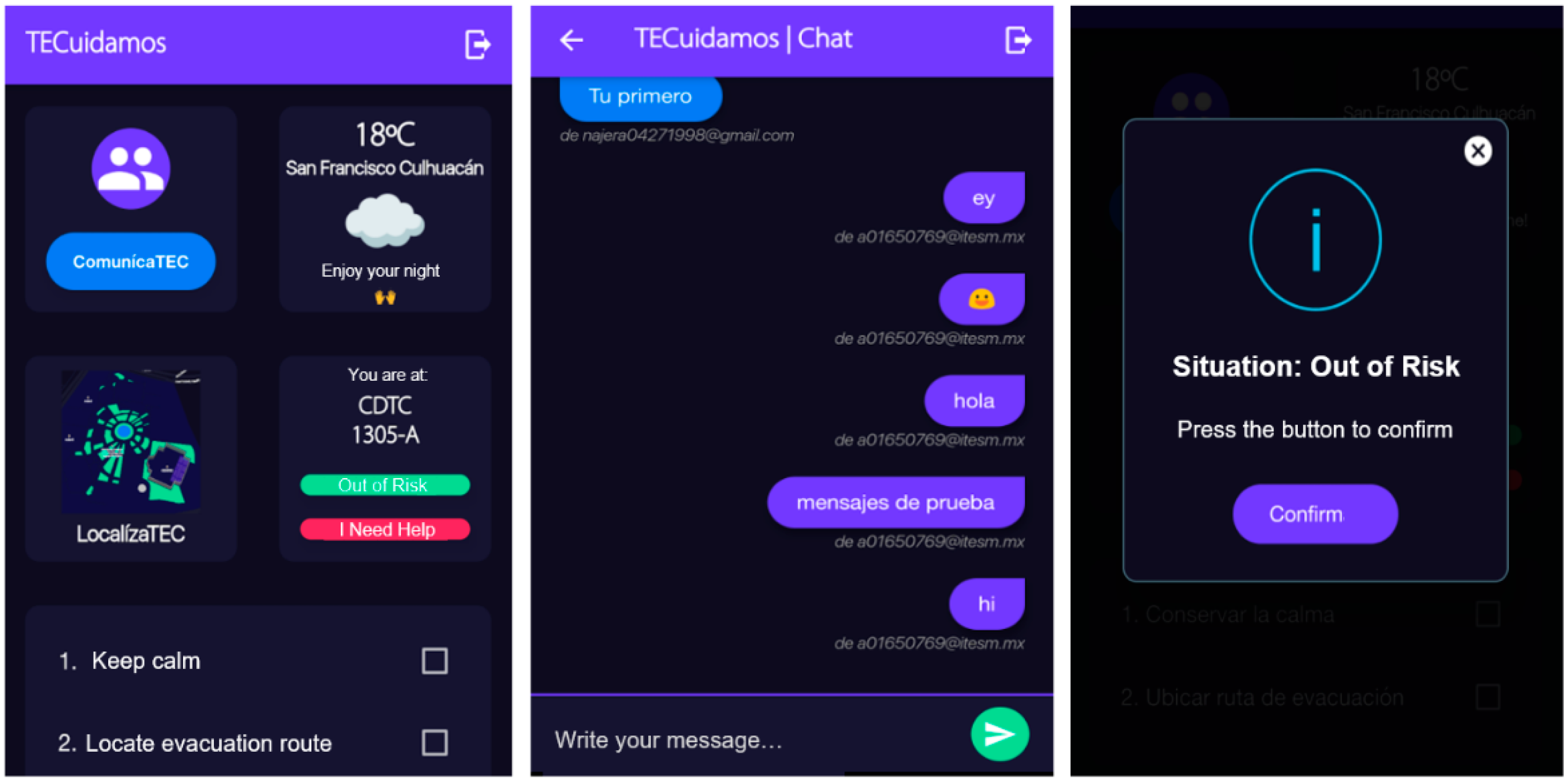
Figure 9 shows three windows of the TECuidamos user interface. The window on the left shows the starting TECuidamos user interface menu. The second window shows the TECuidamos chat window with evidence of a test of the communication function between the user and the administrator with the main objective of reporting any emergency. In the interface menu, there are two buttons to communicate the user status: the green button with the legend “Out of risk” and the red button with the legend “I need help”. If the user presses the “Out of Risk” button, then the window shown on the right window will be displayed where the user needs to confirm that he/she is ok. However, if the user presses the “I need button” and confirms the status, then an alarm is set up, notifying the user’s exact location within the building.
It is observed that the route planning algorithm known as A* (searching algorithm that searches for the shortest path between the initial and the final state), developed during the first stage of work, successfully finds the shortest route between a start point and an end point. The output of the algorithm provides a custom path according to a topological distribution of cells, which makes it easy to render maps in closed spaces. The execution time of the algorithm to obtain the most efficient evacuation route was measured based on the two most distant points on the map, achieving a time of 500 milliseconds. It is important to note that when filling in the topology data, care must be taken not to make mistakes, since any incorrect data that is valid can lead to a malfunction or, in this case, the null functioning of the algorithm at the time of route generation. evacuation
7. Discussion
The CBL strategy is an educational technique that can be applied towards real problems that are recurrent and relevant for the society. Specifically, Mexico City suffers from constant telluric movements because it is in the Cocos plate belt. Tragic events have marked this society, and there is a record of two earthquakes that claimed thousands of lives. One was in 1985, where more than 50 thousand citizens perished, and another was in 2017, where society with an advanced civil protection culture avoided a high number of deaths, and there were only around 400 casualties, many of them being people who perished trapped in the rubble of buildings or did not know the least dangerous way to escape from the event.
In this report, we describe how Telecommunications and Electronic Systems engineering students designed, through CBL, a functional device to prevent a disaster in university buildings during emergency, for instance, earthquakes. It was shown that the system has a student counter per classroom and this function is very helpful because it allows the system to identify the concentration of people in one place. Additionally, the system monitors and analyzes evacuation dynamics and suggests alternate routes. The solution enables real-time communication with the users within the building of the emergency and is a useful tool for the potential victims to receive help in a timely manner.
This experimental development was a multi-semester project, which implies that the challenges are segmented so that students are assigned a grade each semester, depending on their participation. Within this, there are satisfaction surveys and proposals for improvement that are considered for the redesign of the next segment of the challenge, and thus will help improve the experience. Additionally, in this type of course called Engineering Projects, certain graduation competencies are declared for Electronic Engineers, of which we evaluate two of the most important for this challenge:
Design, develop, and implement electronic systems and their embedded software to provide solutions to telecommunications and signal processing problems.
Identify and formulate alternative solutions to real problems, with logically structured procedures and cutting-edge technologies, that allows it to act responsibly in the improvement of the different sectors of the economy and society.
These competencies are monitored by the advisor and professors involved in solving the challenge and are discussed in the final presentation of the project, in addition to the departmental rubric that is designed in a collegiate manner by all the professors of the program. This type of evaluation detects if there is any clear deficiency that needs to be addressed in a specific student and to work together with specialized personnel to improve the acquisition of skills.
Through this kind of challenge, students can apply their knowledge and learn new things by themselves with the objective of proposing a feasible solution for the assigned challenge to have a positive impact in their community and their environment. By engaging students in these relevant challenges, students are motivated to own their learning process and be agents of change prepared with the skills and competencies that the workforce demands. This in fact, is a demonstration that Socially-Oriented Interdisciplinary STEM education is a tool that can solve future problems, as manifested by the device shown in this study.
Author Contributions
Conceptualization, E.L.-C., J.M.-H., V.L.-P. and P.C.; methodology, A.C., S.R., B.N., D.C., D.R., J.L., V.V. and I.L.; software, E.L.-C., A.C., S.R., B.N., J.L., V.V. and I.L.; validation, P.C., V.L.-P. and J.M.-H.; formal analysis, A.C., S.R., B.N., J.L., V.V. and I.L.; investigation, E.L.-C., J.M.-H., P.C., V.L.-P.; resources, E.L.-C., J.M.-H.; writing—original draft preparation, E.L.-C., J.M.-H., V.L.-P. and P.C. All authors have read and agreed to the published version of the manuscript.
Funding
This research was partially funded by the NOVUS [Tecnologico de Monterrey] Projects PHHT085-21ZZNV016 and FN-132002-001, and by the Writing Lab [Institute for the Future of Education, Tecnologico de Monterrey].
Institutional Review Board Statement
Not applicable.
Informed Consent Statement
Not applicable.
Data Availability Statement
Not applicable.
Conflicts of Interest
The authors declare no conflict of interest.
References
- Singh, S.K.; Reinoso, E.; Arroyo, D.; Ordaz, M.; Cruz-Atienza, V.; Pérez-Campos, X.; Iglesias, A.; Hjörleifsdóttir, V. Deadly Intraslab Mexico Earthquake of 19 September 2017 (M w 7.1): Ground Motion and Damage Pattern in Mexico City. Seismol. Res. Lett. 2018, 89, 2193–2203. [Google Scholar] [CrossRef] [Green Version]
- Galvis, F.; Miranda, E.; Heresi, P.; Dávalos, H.; Silos, J.R. Preliminary Statistics of Collapsed Buildings in Mexico City in the September 19, 2017 Puebla-Morelos Earthquake; John, A., Ed.; Blume Earthquake Engineering Center and Department of Civil and Environmental Engineering Stanford University: Stanford, CA, USA, 2017. [Google Scholar]
- Amiresmaili, M.; Zolala, F.; Nekoei-Moghadam, M.; Salavatian, S.; Chashmyazdan, M.; Soltani, A. Role of Social Media in Earthquake: A Systematic Review. Iran. Red Crescent Med. J. 2021, 23, e477. [Google Scholar]
- Bernardini, G.; Santarelli, S.; Quagliarini, E.; D’orazio, M. Dynamic Guidance Tool for a Safer Earthquake Pedestrian Evacuation in Urban Systems. Comput. Environ. Urban Syst. 2017, 65, 150–161. [Google Scholar] [CrossRef]
- Caratozzolo, P.; Membrillo-Hernández, J. Evaluation of Challenge Based Learning Experiences in Engineering Programs: The Case of the Tecnologico de Monterrey, Mexico. In Proceedings of the Visions and Concepts for Education 4.0, McMAster University, Hamilton, ON, Canada, 14–16 October 2020; Auer, M.E., Centea, D., Eds.; Springer International Publishing: Cham, Switzerland, 2021; pp. 419–428. [Google Scholar]
- Kukreti, A.R.; Broering, J. An Entrepreneurship Venture for Training K-12 Teachers to Use Engineering as a Context for Learning. Educ. Sci. 2019, 9, 54. [Google Scholar] [CrossRef] [Green Version]
- Meyer, H. Teachers’ Thoughts on Student Decision Making During Engineering Design Lessons. Educ. Sci. 2018, 8, 9. [Google Scholar] [CrossRef] [Green Version]
- Membrillo-Hernández, J.; de Jesús Ramírez-Cadena, M.; Ramírez-Medrano, A.; García-Castelán, R.M.G.; García-García, R. Implementation of the Challenge-Based Learning Approach in Academic Engineering Programs. Int. J. Interact. Des. Manuf. 2021, 15, 287–298. [Google Scholar] [CrossRef]
- Lara-Prieto, V.; Flores-Garza, G.E. IWeek Experience: The Innovation Challenges of Digital Transformation in Industry. Int. J. Interact. Des. Manuf. 2022, 16, 81–98. [Google Scholar] [CrossRef]
- Membrillo-Hernández, J.; García-García, R. Challenge-Based Learning (CBL) in Engineering: Which Evaluation Instruments Are Best Suited to Evaluate CBL Experiences? In Proceedings of the 2020 IEEE Global Engineering Education Conference (EDUCON), Porto, Portugal, 27–30 April 2020; pp. 885–893. [Google Scholar]
- Vilar, E.; Rebelo, F.; Noriega, P.; Teles, J.; Mayhorn, C. The Influence of Environmental Features on Route Selection in an Emergency Situation. Appl. Ergon. 2013, 44, 618–627. [Google Scholar] [CrossRef] [PubMed]
- Shimura, Y.; Yamamoto, K. Method of Searching for Earthquake Disaster Evacuation Routes Using Multi-Objective GA and GIS. J. Geogr. Inf. Syst. 2014, 6, 492–525. [Google Scholar] [CrossRef] [Green Version]
- Han, R.; Yu, Y.; Zhao, X.; Peng, D.; Guan, Q.; Li, M.; Ou, J. Emergency Communication and Quick Seismic Damage Investigation Based on Smartphone. Adv. Mater. Sci. Eng. 2016, 2016, 7456182. [Google Scholar] [CrossRef] [Green Version]
- Annadata, P.; Eltarjaman, W.; Thurimella, R. Person Detection Techniques for an IoT Based Emergency Evacuation Assistance System. In Proceedings of the 13th International Conference on Mobile and Ubiquitous Systems: Computing Networking and Services, Hiroshima, Japan, 28 November–1 December 2016; Association for Computing Machinery: New York, NY, USA, 2016; pp. 77–82. [Google Scholar]
- Penmetcha, M.; Samantaray, A.; Min, B.-C. SmartResponse: Emergency and Non-Emergency Response for Smartphone Based Indoor Localization Applications. In HCI International 2017—Posters’ Extended Abstracts; Stephanidis, C., Ed.; Springer International Publishing: Cham, Switzerland, 2017; pp. 398–404. [Google Scholar]
- Xu, X.; Zhang, L.; Sotiriadis, S.; Asimakopoulou, E.; Li, M.; Bessis, N. CLOTHO: A Large-Scale Internet of Things-Based Crowd Evacuation Planning System for Disaster Management. IEEE Internet Things J. 2018, 5, 3559–3568. [Google Scholar] [CrossRef]
- Zualkernan, I.A.; Aloul, F.A.; Sakkia, V.; Noman, H.A.; Sowdagar, S.; Hammadi, O.A. An IoT-Based Emergency Evacuation System. In Proceedings of the 2019 IEEE International Conference on Internet of Things and Intelligence System (IoTaIS), Bali, Indonesia, 5–7 November 2019; pp. 62–66. [Google Scholar]
- He, J. Earthquake Evacuation Simulation of Multi-Story Buildings during Earthquakes. Earthq. Spectra 2021, 37, 95–113. [Google Scholar] [CrossRef]
- Ooi, S.; Kikuchi, A.; Goto, T.; Sano, M. Development and Verification of Mixed Disaster Training System in Virtual Reality Based on Experience Learning. In Proceedings of the 2021 10th International Conference on Educational and Information Technology (ICEIT), Chengdu, China, 18–20 January 2021; pp. 29–33. [Google Scholar]
- Sun, T.; Lin, J.; Xiong, K.; Xiao, C. Route Recommendation for Evacuation Networks Using MMPP/M/1/N Queueing Models. Comput. Commun. 2022, 185, 23–39. [Google Scholar] [CrossRef]
- Hassanpour, S.; Gonzalez, V.; Liu, J.; Zou, Y.; Cabrera-Guerrero, G. A Hybrid Hierarchical Agent-Based Simulation Approach for Buildings Indoor Layout Evaluation Based on the Post-Earthquake Evacuation. Adv. Eng. Inform. 2022, 51, 101531. [Google Scholar] [CrossRef]
- Lorusso, P.; De Iuliis, M.; Marasco, S.; Domaneschi, M.; Cimellaro, G.P.; Villa, V. Fire Emergency Evacuation from a School Building Using an Evolutionary Virtual Reality Platform. Buildings 2022, 12, 223. [Google Scholar] [CrossRef]
- Tipler, K.; Tarrant, R.; Tuffin, K.; Johnston, D. Learning from Experience: Emergency Response in Schools. Nat. Hazards 2018, 90, 1237–1257. [Google Scholar] [CrossRef]
- Zhang, Z.; Zhao, Z. A Multiple Mobile Robots Path Planning Algorithm Based on A-Star and Dijkstra Algorithm. Int. J. Smart Home 2014, 8, 75–86. [Google Scholar] [CrossRef] [Green Version]
- ABET. Criteria for Accrediting Engineering Programs, 2022–2023; ABET: Baltimore, MD, USA, 2019. [Google Scholar]
- Caratozzolo, P.; Alvarez-Delgado, A.; Hosseini, S. Fostering Specific Dispositions of Critical Thinking for Student Engagement in Engineering. In Proceedings of the 2019 IEEE Global Engineering Education Conference (EDUCON), Dubai, United Arab Emirates, 9–11 April 2019; pp. 221–226. [Google Scholar]
- Caratozzolo, P.; Alvarez-Delgado, A.; Hosseini, S. Improving Creative Thinking in Engineering Students through Art Appreciation. In Proceedings of the 2019 ASEE Annual Conference & Exposition (ASEE), Tampa, FL, USA, 15 June 2019. [Google Scholar]
- Caratozzolo, P.; Alvarez-Delgado, A.; Hosseini, S. Metacognitive Awareness and Creative Thinking: The Capacity to Cope with Uncertainty in Engineering. In Proceedings of the 2020 IEEE Global Engineering Education Conference (EDUCON), Porto, Portugal, 27–30 April 2020; pp. 638–643. [Google Scholar]
| Publisher’s Note: MDPI stays neutral with regard to jurisdictional claims in published maps and institutional affiliations. |
© 2022 by the authors. Licensee MDPI, Basel, Switzerland. This article is an open access article distributed under the terms and conditions of the Creative Commons Attribution (CC BY) license (https://creativecommons.org/licenses/by/4.0/).


 ,
, 


