
Landscape Design for Flood Adaptation from 20 Years of Constructed Ecologies in China

Abstract
:1. Introduction
- Clarify how and where landscape architecture integrates flood mitigation responses in relation to various floodplain landforms and local micro-climates.
- Generate new understanding to support urban and landscape design to define optimal design responses to flood according to distinctive contexts.
- Define a framework to assist future systematic monitoring of flood tolerant infrastructures.
2. Materials and Methods
2.1. Case Study Method and Research-by-Design
2.2. China Sponge City Initiative

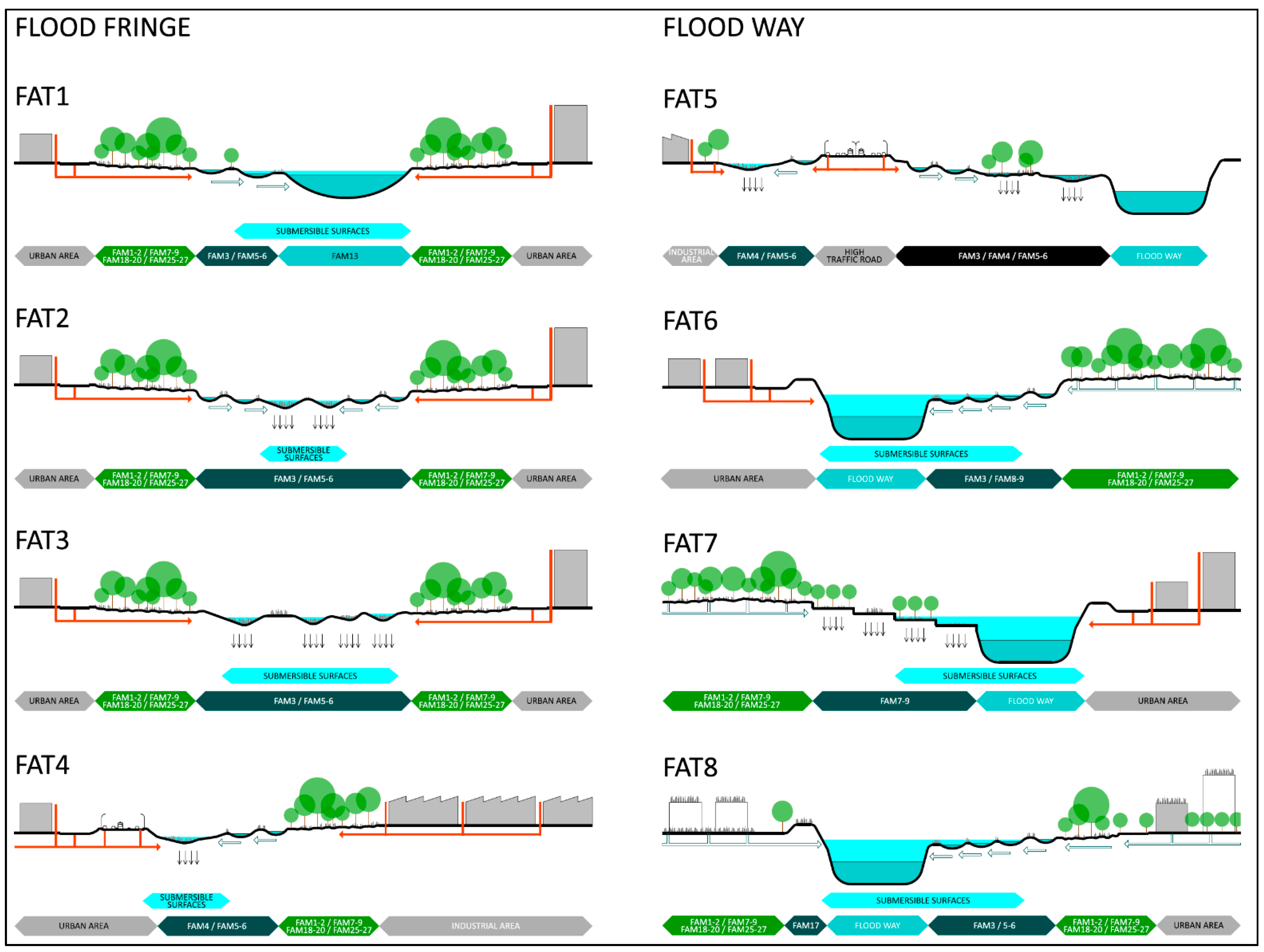
| FLOOD ADAPTATION TYPE | FAT1 | FAT2 | FAT3 | FAT4 | FAT5 | FAT6 | FAT7 | FAT8 | |
|---|---|---|---|---|---|---|---|---|---|
| Flood Adaptive Developments | Wetlands Parks | Bioretention Corridors | Stormwater Sponges | Blue-Green Buffers | Floodable Wetlands | Terraced Wetlands | Water Sensitive Networks | ||
| Flood Fringe (FF) Flood Way (FW) | FF | FF | FF | FF | FW | FW | FW | FW | |
| Flood Adaptation function | INFILTRATION | X | X | X | |||||
| PURIFICATION | X | X | X | X | X | X | |||
| CONVEYANCE | X | X | X | ||||||
| RETENTION | X | X | X | X | |||||
| DETENTION | X | X | X | X | X | X | |||
| ATTENUATION | X | X | X | ||||||
| CLIMATE ZONE | A (Aw) | X | |||||||
| B (Bsk) | X | X | X | X | X | ||||
| C (Cfa, Cwa, Cwb) | X | X | X | X | X | ||||
| D (Dwa) | X | X | X | ||||||
| size | L | M | L | S | L/M | L/M | S/M | L | |
| PROJECT # | P12, P13 | P10, P18 | P1, P20 | P2, P14, P16, P17, P22, P24, P29 | P3, P9, P16, P23, P27 | P5, P6, P11, P19, P21 | P4, P7, P15, P25, P28 | P8, P30 | |
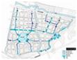
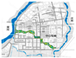
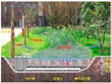
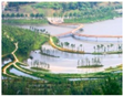
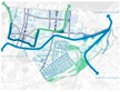
| Example of project | P12—Ningbo Cicheng New District | P10—Qunli Yuhong Wetlands Park | P1—Xixian New District Central Green Corridor | P29—Western cloud Valley, Xixian New Area, Xi’an | P9—Kunshan Green-blue-grey buffer | P6—Liupanshan Minghu wetland park | P27—Meishe River Greenway and Fengxiang Park | P30—Qinhuai district, Nanjing | |
 |  |  |  |  |  |  |  |
3. Designed Ecologies for Flood Resilience: Foundational Principles
Flood Adaptation Measures
- infiltration (to recharge aquifers)
- purification (to clean runoff)
- conveyance (to move stormwater)
- retention (to reuse rainwater)
- detention (to delay stormwater)
- attenuation (to slow down flood water)
4. Results: Flood Adaptation Types
Flood Adaptation Types
5. Discussion
- Both conveyance and retention objectives can include purification, but infiltration is associated only with retention.
- Purification functions are typically associated with stormwater retention if the final aim is reuse in the public space.
- Detention usually include infiltration to allow stormwater to seep through the ground before discharge and decreases runoff, such as in large scale stream daylighting catchment corridors.
- Ecological functions associated with purification and infiltration of stormwater are not always compatible with public recreation functions and they need to be excluded from accessible areas.
6. Conclusions
Author Contributions
Funding
Institutional Review Board Statement
Informed Consent Statement
Data Availability Statement
Conflicts of Interest
References
- O’Donnell, E.C.; Thorne, C.R. Drivers of future urban flood risk. Philos. Trans. R. Soc. A 2020, 378, 20190216. [Google Scholar] [CrossRef] [Green Version]
- Fernando, N.S.; Shrestha, S.; Saurav, K.C.; Mohanasundaram, S. Investigating major causes of extreme floods using global datasets: A case of Nepal, USA & Thailand. Prog. Disaster Sci. 2022, 13, 100212. [Google Scholar]
- Miller, J.D.; Hutchins, M. The impacts of urbanisation and climate change on urban flooding and urban water quality: A review of the evidence concerning the United Kingdom. J. Hydrol. Reg. Stud. 2017, 12, 345–362. [Google Scholar] [CrossRef] [Green Version]
- Liao, K. A theory on urban resilience to floods—A basis for alternative planning practices. Ecol. Soc. 2012, 17, 48. [Google Scholar] [CrossRef]
- Centre for Liveable Cities. The Active, Beautiful, Clean Waters Programme: Water as an Environmental Asset; Centre for Liveable Cities: Singapore, 2017. [Google Scholar]
- Vojinovic, Z. Nature-Based Solutions for Flood Mitigation and Coastal Resilience: Analysis of EU-Funded Projects; European Commission: Brussels, Belgium, 2020. [Google Scholar]
- Liu, H.; Jia, Y.; Niu, C. “Sponge city” concept helps solve China’s urban water problems. Environ. Earth Sci. 2017, 76, 473. [Google Scholar] [CrossRef]
- Ahern, J. From Fail-Safe to Safe-to-Fail: Sustainability and Resilience in the New Urban World. Available online: https://scholarworks.umass.edu/larp_grad_research/8/ (accessed on 12 March 2022).
- Lennon, M.; Scott, M.; Neill, E.O. Urban design and adapting to flood risk. In The Role of Green Infrastructure Urban Design and Adapting to Flood Risk; Taylor Francis Group: Abingdon, UK, 2014; Volume 4809. [Google Scholar] [CrossRef]
- Cahill, T.H. Low Impact Development and Sustainable Stormwater Management; John and Wiley and Sons: Hoboken, NJ, USA, 2012. [Google Scholar]
- Wang, S.; Palazzo, E. Sponge City and social equity: Impact assessment of urban stormwater management in Baicheng City, China. Urban Clim. 2021, 37, 100829. [Google Scholar] [CrossRef]
- Intergovernmental Panel on Climate Change. Annex I: Glossary. In Climate Change and Land: An IPCC Special Report on Climate Change, Desertification, Land Degradation, Sustainable Land Management, Food Security, and Greenhouse Gas Fluxes in Terrestrial Ecosystems; Shukla, P.R., Van Diemen, S., Eds.; Intergovernmental Panel on Climate Change: Geneva, Switzerland, 2019; pp. 803–829. [Google Scholar]
- Wagenaar, D.J.; Dahm, R.J.; Diermanse, F.L.M.; Dias, W.P.S.; Dissanayake, D.M.S.S.; Vajja, H.P.; Gehrels, J.C.; Bouwer, L.M. Evaluating adaptation measures for reducing flood risk: A case study in the city of Colombo, Sri Lanka. Int. J. Disaster Risk Reduct. 2019, 37, 101162. [Google Scholar] [CrossRef]
- Verburg, P.H.; Koomen, E.; Hilferink, M. An assessment of the impact of climate adaptation measures to reduce flood risk on ecosystem services. Landsc. Ecol. 2012, 27, 473–486. [Google Scholar] [CrossRef] [Green Version]
- Shaw, J.K.E.; Watt, W.E.; Marsalek, J.; Anderson, B.C.; Crowder, A.A. Flow pattern characterization in an urban stormwater detention pond and implications for water quality. Water Qual. Res. J. 1997, 32, 53–72. [Google Scholar] [CrossRef]
- Schwartz, D.; Sample, D.J.; Grizzard, T.J. Evaluating the performance of a retrofitted stormwater wet pond for treatment of urban runoff. Environ. Monit. Assess. 2017, 189, 256. [Google Scholar] [CrossRef]
- Fowdar, H.; Payne, E.; Deletic, A.; Zhang, K.; McCarthy, D. Advancing the Sponge City Agenda: Evaluation of 22 plant species across a broad range of life forms for stormwater management. Ecol. Eng. 2022, 175, 106501. [Google Scholar] [CrossRef]
- Matos Silva, M.; Costa, J.P. Flood adaptation measures applicable in the design of urban public spaces: Proposal for a conceptual framework. Water 2016, 8, 284. [Google Scholar] [CrossRef] [Green Version]
- Le, T.Q.; Devisch, O.; Trinh, T.A. Flood-resilient urban parks: Toward a framework. Area 2019, 51, 804–815. [Google Scholar] [CrossRef]
- Palazzo, E. From water sensitive to floodable: Defining adaptive urban design for water resilient cities. J. Urban Des. 2019, 24, 137–157. [Google Scholar] [CrossRef]
- Prominski, M. Design research as a non-linear interplay of five moments. In Design Research for Urban Landscapes; Prominski, M., Von Saggern, H., Eds.; Taylor Francis Group: Abingdon, UK, 2019. [Google Scholar]
- Psarra, I.; Altınkaya Genel, Ö.; Van Spyk, A. A research-by-design strategy for climate adaptation solutions: Implementation in the low-density, high flood risk context of the lake district, UK. Sustainability 2021, 13, 11847. [Google Scholar] [CrossRef]
- Brasch, J. Floodable urban landscapes for a resilient city: Potential for the City of Seattle. University of Washington, Washington, WA, USA, 2019. ProQuest Dissertations Publishing. 13900476. Water Res. 2019, 42, 3930–3940. [Google Scholar]
- Von Saggern, H. Crossing fields: Designing and researching Raumgeschehen. In Design Research for Urban Landscapes; Prominski, M., Von Saggern, H., Eds.; Taylor Francis Group: Abingdon, UK, 2019. [Google Scholar]
- Moneo, R. On typology. In Oppositions; MIT Press: Cambridge, MA, USA, 1978; pp. 23–45. [Google Scholar]
- Garzino, G.; Bocconcino, M.M.; Vozzola, M.; Mazzone, G. Dalla rappresentazione della vulnerabilità urbana: Il disegno di abachi grafici per il Progetto. Disegno 2021, 8, 221–232. [Google Scholar] [CrossRef]
- Yu, K.; Chen, Y. Research progress on traditional agricultural water-adaptive landscapes in abroad. China Water Resour. 2014, 3, 13–16. [Google Scholar]
- Chen, Y.; Yu, K. Thought of ancient “sponge city”: Experiences of applying water-adaptive landscape. China Water Resour. 2015, 17, 19–22. [Google Scholar]
- Wu, Y.C. Analysis of frequent urban waterlogging disasters in China. Flood Prev. Drought Relief China 2011, 21, 7–8. [Google Scholar]
- Qi, Y.; Chan, F.K.S.; Thorne, C.; O’Donnell, E.; Quagliolo, C.; Comino, E.; Pezzoli, A.; Li, L.; Griffiths, J.; Sang, Y.; et al. Addressing challenges of urban water management in Chinese sponge cities via nature-based solutions. Water 2020, 12, 2788. [Google Scholar] [CrossRef]
- Millennium Ecosystem Assessment. Ecosystems and Human Well-Being: Synthesis; Island Press: Washington, WA, USA, 2005. [Google Scholar]
- Qiao, X.J.; Liao, K.H.; Randrup, T.B. Sustainable stormwater management: A qualitative case study of the Sponge Cities initiative in China. Sustain. Cities Soc. 2020, 53, 101963. [Google Scholar] [CrossRef]
- Yu, K.; Xu, T.; Li, D.; Wang, C. A river urban water resilience. Urban Plan. Rev. 2015, 1, 75–83. [Google Scholar]
- Li, F.; Zhang, J. A review of the progress in Chinese Sponge City programme: Challenges and opportunities for urban stormwater management. Water Supply 2022, 22, 1638–1651. [Google Scholar] [CrossRef]
- Chen, S.; Van De Ven, F.H.M.; Zevenbergen, C.; Verbeeck, S.; Ye, Q.; Zhang, W.; Wei, L. Revisiting China’s Sponge City planning approach: Lessons from a case study on Qinhuai District, Nanjing. Front. Environ. Sci. 2021, 9, 428. [Google Scholar] [CrossRef]
- Steiner, F. Frontiers in urban ecological design and planning research. Landsc. Urban Plan. 2014, 125, 304–311. [Google Scholar] [CrossRef]
- Holling, C.S.; Gunderson, L.H. Panarchy: Understanding Transformations in Human and Natural Systems; Gunderson, L.H., Holling, C.S., Eds.; Island Press: Washington, WA, USA, 2002. [Google Scholar]
- Caldarice, O.; Brunetta, G.; Tollin, N. The challenge of urban resilience: Operationalization. In Urban Resilience for Risk and Adaptation Governance. Resilient Cities (Re-Thinking Urban Transformation); Brunetta, G., Caldarice, O., Tollin, N., Rosas-Casals, M., Morató, J., Eds.; Springer: Berlin/Heidelberg, Germany, 2019. [Google Scholar] [CrossRef]
- Ahern, J. Urban landscape sustainability and resilience: The promise and challenges of integrating ecology with urban planning and design. Landsc. Ecol. 2013, 28, 1203–1212. [Google Scholar] [CrossRef]
- Brandt, J.; Vejre, H. Multifunctional landscapes—Motives, concepts and perceptions. In Multifunctional Landscapes: Theory, Values and History; Brandt, J., Vejre, H., Eds.; WIT Press: Southampton, UK, 2004; Volume 1, pp. 3–32. [Google Scholar]
- Naveh, Z. Ten major premises for a holistic conception of multifunctional landscapes. Landsc. Urban Plan. 2001, 57, 269–284. [Google Scholar] [CrossRef]
- O’Farrell, P.J.; Anderson, P.M.L. Sustainable multifunctional landscapes: A review to implementation. Environ. Sustain. 2010, 2, 59–65. [Google Scholar] [CrossRef]
- Ferreira, C.S.S.; Potočki, K.; Kapović-Solomun, M.; Kalantari, Z. Nature-based solutions for flood mitigation and resilience in urban areas. In The Handbook of Environmental Chemistry; Springer: Berlin/Heidelberg, Germany, 2021. [Google Scholar] [CrossRef]
- Quinn, P.; O’Donnell, G.; Nicholson, A.; Wilkinson, M.; Owen, G.; Jonczyk, J.; Barber, N.; Hardwick, M.; Davies, G. Potential Use of Runoff Attenuation Features in Small Rural Catchments for Flood Mitigation: Evidence from Belford, Powburn and Hepscott; Joint Newcastle University: Newcastle, UK, 2013. [Google Scholar]
- Nicholson, A.; Wilkinson, M.; O’Donnell, G.; Quinn, P. Runoff attenuation features: A sustainable flood mitigation strategy in the Belford catchment, UK. Area 2012, 44, 463–469. [Google Scholar] [CrossRef]
- Li, C.; Wang, S.; Fang, X.; Yuan, D.; Li, H. Analysis on the reduction effect and influence factors of the sunken green space on stormwater runoff pollutant. Sci. Technol. Eng. 2018, 18, 215–224. [Google Scholar]
- Public Utilities Board. Active, Beautiful, Clean Waters Design Guidelines, 4th ed.; Public Utilities Board: Singapore, 2018. Available online: https://www.pub.gov.sg/Documents/ABC_Waters_Design_Guidelines.pdf (accessed on 15 January 2022).
- Ferguson, B.K. Stormwater Infiltration; CRC Press: Boca Raton, FL, USA, 1994. [Google Scholar]
- Davis, A.P.; Traver, R.G.; Hunt, W.F. Improving urban stormwater quality: Applying fundamental principles. J. Contemp. Water Res. Educ. 2010, 146, 3–10. [Google Scholar] [CrossRef]
- Bratieres, K.; Fletcher, T.D.; Deletic, A.; Zinger, Y. Nutrient and sediment removal by stormwater biofilters: A large-scale design optimisation study. Water Res. 2008, 42, 3930–3940. [Google Scholar] [CrossRef] [PubMed]
- Tsihrintzis, V.A.; Hamid, R. Modelling and management of urban stormwater runoff quality: A review. Water Resour. Manag. 1997, 11, 136–164. [Google Scholar] [CrossRef]
- Wanielista, M.P.; Youssef, Y.A. Stormwater Management; John and Wiley and Sons: New York, NY, USA, 1993. [Google Scholar]
- Centre for Watershed Protection. Maryland Stormwater Design Manual, Volumes I and II; Centre for Watershed Protection: Baltimore, MD, USA, 2000. Available online: https://mde.maryland.gov/programs/Water/StormwaterManagementProgram/Documents/www.mde.state.md.us/assets/document/sedimentstormwater/Glossary.pdf (accessed on 21 February 2022).
- Nicholson, A.R.; O’Donnell, G.M.; Wilkinson, M.E.; Quinn, P.F. The potential of runoff attenuation features as a Natural Flood Management approach. J. Flood Risk Manag. 2020, 13, e12565. [Google Scholar] [CrossRef] [Green Version]
- Palazzo, E.; Wan, N. Regenerating urban areas through climate sensitive urban design. Adv. Sci. Lett. 2017, 23, 6394–6398. [Google Scholar] [CrossRef]
- Arnfield, A.J. Köppen Climate Classification. 2020. Available online: https://www.britannica.com/science/Koppen-climate-classification (accessed on 19 February 2022).
- Encyclopedia Britannica. Floodplain. 2018. Available online: https://www.britannica.com/science/floodplain (accessed on 19 February 2022).

| FLOOD ADAPTATION FUNCTIONAL OBJECTIVES | |||||||||
|---|---|---|---|---|---|---|---|---|---|
| F.A.M. | Sub-Category | F.A.M. NAME | F.A.M. Description | INFILTRATION | PURIFICATION | CONVEYANCE | RETENTION | DETENTION | ATTENUATION |
| LARGE (SCALE OF THE CATCHMENT) | |||||||||
| FAM1 | Stream recovery | Stream restoration or rehabilitation | Improvement of ecological functions of rivers or streams, to support biodiversity, that allows a range of ecosystem services including public recreation, leisure and play, flood management and landscape regeneration. | X | X | X | |||
| FAM2 | Stream recovery | Stream daylighting | The process of removing concrete pipes, culverts or pavements concealing a water way such as in canals or drainage systems and restoring them to more natural conditions. | X | X | X | X | ||
| FAM3 | Bioretention | Wet bioretention basins/constructed wetland | A system of shallow depressions in the ground or ponds, often planted, designed to retain, detain, and purify stormwater before it is infiltrated or discharged downstream. | X | X | X | X | ||
| FAM4 | Bioretention | Dry bioretention basins/grass bioswales | A shallow depression in the ground, sometimes planted, designed to facilitate stormwater infiltration and water table recharge, mimicking dry riverbeds found in nature. | X | X | X | X | ||
| MEDIUM (SCALE OF THE SITE) | |||||||||
| FAM5 | Infiltration techniques | Bioswales | A shallow and narrow planted channel designed to filter and purify stormwater runoff by removing debris and pollution before conveying it to designated infiltration areas. | X | X | X | |||
| FAM6 | Infiltration techniques | Infiltration trenches | A shallow excavated trench filled with gravel or aggregates designed to filtrate stormwater before releasing it to groundwater aquifers. | X | |||||
| FAM7 | Flood proof surfaces | Submersible parks and gardens | Green areas accessible to the public designed to periodically flood retain stormwater and prevent flooding elsewhere. They provide a range of ecosystem services including recreational and ecological functions. | X | X | X | X | ||
| FAM8 | Flood proof surfaces | Submersible planting | Landscape interventions in floodplains to reduce surface Runoff flow velocities using wooden barriers, weirs, temporary storage basins, riparian woodland, and vegetation patches. | X | X | X | |||
| FAM9 | Flood proof surfaces | Submersible pathways | Pathways accessible to the public designed to be periodically inundated to facilitate stormwater infiltration. | X | X | ||||
| FAM10 | Open drainage systems | Street channels | Paved concrete or stone surfaces along roads designed to collect and convey stormwater. | X | X | ||||
| FAM11 | Open drainage systems | Stream channel enlargement | Enlargement of streams capacity in response to changing flow regimens for instance accompanying urbanization and new impervious development. | X | X | ||||
| FAM12 | Open drainage systems | Check dams | Small, or sometimes temporary, dams, dykes or breakwater constructed across a swale, drainage ditch, or waterway to reduce soil erosion by slowing down flow velocity. | X | X | ||||
| FAM13 | Reservoirs | Artificial detention basins | Artificial lakes or ponds to harvest and store rainwater for later uses. | X | X | ||||
| FAM14 | Reservoirs | Water plazas | Public places aimed at reducing water logging in urban areas. Usually integrate a mix of paved and planted surfaces for harvest, infiltration, and storage in basins to collect runoff. Disconnected from centralized drainage systems they can accommodate different volumes of flood. | X | |||||
| FAM15 | Reservoirs | Underground reservoirs | Underground water storage built to retain stormwater and gradually release it to the water table. | X | |||||
| FAM16 | Reservoirs | Cisterns | External tanks for harvesting and storing water for later reuse. | X | |||||
| FAM17 | Floodwalls/green levees | Green embankments and levees | Planted soft embankments of rivers and gullies designed to improve flood storage capacity and ecological functions. | X | X | X | X | ||
| SMALL (SCALE OF THE FACILITY) | |||||||||
| FAM18 | Raised structures | Elevated promenades | Pathways for pedestrian access and cycling mobility that are on a higher level than surrounding terrain. Usually built on stilts to avoid inundation. | X | |||||
| FAM19 | Floating structures | Floating pathways and platforms | Pathways and platforms floating over a water body to allow pedestrian and cycling access across lakes, rivers, and canals. They allow water conveyance and are not disrupted by flood as they move with different water levels. | X | |||||
| FAM20 | Floating structures | Floating islands | Floating aquatic plants, mud, and peat ranging in thickness from several centimeters to a few meters floating on water bodies. They enable ecological functions and may attenuate flood velocity and impact. | X | |||||
| FAM21 | Ground detention | Bioretention planters | Curbside containers designed for stormwater retention and infiltration. Constructed with walled vertical sides and a large surface capacity to capture, treat, and manage runoff from streets. | X | X | X | X | ||
| FAM22 | Ground detention | Rain gardens | Shallow depression designed and planted to detain stormwater before it is infiltrated or discharged in the drainage network. | X | X | X | |||
| FAM23 | Rooftop detention | Green roofs | A roof of a building that is partially or completely covered with vegetation and a growing medium, planted over waterproofed and root barrier membranes. | X | X | ||||
| FAM24 | Rooftop detention | Blue roofs | A roof of a building that is expressly designed to provide temporary water detention and gradual release of stored water. It may or may not be planted and typically presents a sand or mineral aggregates layer for retention. | X | X | X | |||
| FAM25 | Pervious paving | Open cell/grass pavers | Pavers designed to create an open hollows pattern filled with gravel or turf to increase permeability up to 50%. | X | X | ||||
| FAM26 | Pervious paving | Interlocking pavers | Interlocking concrete blocks laid on a loose sand layer and open joints to increase permeability up to 30%. | X | X | X | |||
| FAM27 | Pervious paving | Porous paving | Paving made of special porous concrete or aggregate with a high porosity that allows rainwater seepage and conveyance. | X | X | ||||
| PROJECT # | PROJECT NAME | LOCATION | YEAR OF CONSTRUCTION | DESIGN INSTITUTE | SIZE (Ha) | Flood Way (FW) and Flood Fringe (FF) | CLIMATE CLASSIFICATION (KOPPEN): A (Tropical) B (Dry) C (Temperate) D (Continental) | FAMs |
|---|---|---|---|---|---|---|---|---|
| P1 | Xixian New District Central Green Corridor | Xi’an, Shaanxi Province | 2015 | Beijing Turenscape Urban Planning and Design Co., LTD. | 180 | FF | Bsk-Cwa/cold semi-Arid temperate | 3, 4, 5, 6, 13, 18, 22, 25, 27 |
| P2 | Beijing Yizhuang Multifunctional Stormwater Park | Beijing | 2009 | Beijing University of Civil Engineering and Architecture, Urban Planning and Environmental Design Research Center of Beijing Economic and Technological Development Zone, Beijing Municipal Design and Research Institute | 7.6 | FF | BSk-Cold semi-arid | 3, 7, 9, 17, 20, 22 |
| P3 | Railway Station Bridge Rainwater Sponge Park | Guyuan, Ningxia Hui Autonomous Region | 2018 | Ningxia Capital Sponge City Construction and Development Co., LTD., China Municipal Engineering Northwest Design and Research Institute Co., LTD. | S | FW | Bsk-Dwb/cold semi-Arid continental | 1, 3, 4, 13 |
| P4 | Yinma River Wetland Park | Guyuan, Ningxia Hui Autonomous Region | 2018 | Ningxia Capital Sponge City Construction and Development Co., LTD., Beijing Normal University, Beilin Landscape Garden Planning and Design Institute Co., LTD., Yellow River Survey planning and Design Co., LTD. | 16.6 | FW | Bsk-Dwb/cold semi-Arid continental | 3, 4, 7, 11, 12, 13, 17 |
| P5 | Jinhua Yanweizhou Park | Jinhua, Zhejiang Province | 2014 | Beijing Turenscape Urban Planning and Design Co., LTD. | 26 | FW | Cfa-Humid Subtropical | 3, 5, 7, 8, 9, 11, 12, 13, 14, 17, 18, 20, 22, 27 |
| P6 | Liupanshui City Minghu Wetland Park | Liupanshui, Guizhou Province | 2012 | Beijing Turenscape Urban Planning and Design Co., LTD. | 90 | FW | Cwb-Subtropical highland climate | 1, 3, 7, 9, 12, 13, 14, 16, 17, 20, 22, 27 |
| P7 | Nakao River Park | Nanning, Guangxi Zhuang Autonomous Region | 2017 | Anhui Dongjin Garden Co., LTD. | 72.9 | FW | Cwa-Monsoon-influenced humid subtropical | 1, 3, 4, 5, 13, 17, 22, 25, 27 |
| P8 | Qianan Sanlihe Park | Qianan, Hebei Province | 2010 | Beijing Turenscape Urban Planning and Design Co., LTD. | 135 | FW | Dwa-Monsoon-influenced hot-summer humid continental | 1, 2, 5, 7, 9, 11, 12, 13, 17, 22 |
| P9 | Kunshan Ring Road | Kunshan, Jiangsu Province | 2016 | China Academy of Urban Planning and Design, CRC for Water Sensitive Cities | 4420 | FF | Cfa-Humid Subtropical Climate | 3, 13, 21, 22 |
| P10 | Qunli Yuhong Park | Harbin, Heilongjiang Province | 2011 | Beijing Turenscape Urban Planning and Design Co., LTD. | 34.2 | FF | Dwa-Monsoon-influenced hot-summer humid continental | 3, 5, 13, 18, 22, 27 |
| P11 | Sponge City Adaptive Design in Weihe Floodplain | Xi’an, Shaanxi Province | 2017 | Beijing Tiandi Environment Landscape Planning and Design Consulting Co., LTD. | 125 | FW | Bsk-Cwa/cold semi-Arid temperate | 1, 3, 7, 9, 12, 13, 14, 17 |
| P12 | Ningbo Cicheng New District | Ningbo, Zhejiang Province | 2015 | Ningbo Urban Construction Design and Research Institute Co., LTD., CRC for Water Sensitive Cities | 550 | FF | Cfa-Humid Subtropical | 3, 5, 11, 13, 17 |
| P13 | Oriental Sun City | Beijing | 2003 | SAASAKI, Beijing University of Civil Engineering and Architecture | 234 | FF | BSk-Cold semi-arid | 1, 3, 4, 5, 6, 11, 15, 17, 20, 22 |
| P14 | Hebei Xianghe Happiness Park | Langfang, Hebei Province | 2005 | U.P.Space Landscape Architecture Design Consultants Co., LTD. | 8.5 | FF | BSk-Dwa/Cold semi-arid continental | 4, 5, 14, 22 |
| P15 | Yichang Yunhe Park | Yichang, Hubei Province | 2010 | Beijing Turenscape Urban Planning and Design Co. LTD. | 11.36 | FW | Cwa = Monsoon-influenced humid subtropical | 3, 5, 11, 13, 17, 18, 22 |
| P16 | Sustainable Stormwater Management in ZhejiangLi Industrial Park | Wenling, Zhejiang Province | 2015 | Beijing Tiandi Environment Landscape Planning and Design Consulting Co., LTD. | 34 | FF | Cfa-Humid Subtropical Climate | 3, 5, 10, 11, 13, 15, 16, 21, 22, 23, 25 |
| P17 | Jinglin Ecological Garden | Beijing | 2016 | Beijing Jinglin Landscape Engineering Co., LTD. | 1.79 | FF | BSk-Cold semi-arid | 3, 4, 5, 12, 13, 15, 17, 20, 22, 25, 26, 27 |
| P18 | Tianjin Qiaoyuan Park | Tianjin | 2008 | Beijing Turenscape Urban Planning and Design Co., LTD. | 22 | FF | BSk-Cold semi-arid | 3, 13, 22, 27 |
| P19 | Yongning Jiang Park, Huangyan | Taizhou, Zhejiang Province | 2004 | Beijing Turenscape Urban Planning and Design Co., LTD. | 21.3 | FW | Cfa-Humid Subtropical | 3, 5, 7, 9, 11, 13, 14, 17, 22 |
| P20 | Dong’an Wetland Park | Sanya, Hainan Province | 2012 | Beijing Turenscape Urban Planning and Design Co., LTD. | 66.77 | FF | Aw-Tropical wet | 1, 3, 4, 5, 11, 13, 18, 20, 22 |
| P21 | Harbin Cultural Center Wetland Park | Harbin, Heilongjiang Province | 2013 | Beijing Turenscape Urban Planning and Design Co., LTD. | 118 | FW | Dwa-Monsoon-influenced hot-summer humid continental climate | 3, 5, 17, 18, 20, 22, 27 |
| P22 | Public Housing Exhibition Center at Sino-Singapore Eco-City | Tianjin | 2012 | Tianjin Architectural Design Institute | 0.8 | FF | BSk-Cold semi-arid | 6, 10, 13, 15, 25 |
| P23 | Daguan Wetland Park, Tianhe Smart City | Guangzhou, Guangdong Province | 2015 | Beijing Turenscape Urban Planning and Design Co., LTD. | 46.8 | FF | Cfa-Humid subtropical | 3, 11, 12, 13, 15, 7 |
| P24 | Chinese People’s Political Consultative Conference (CPPCC) Office Area Sponge Project | Nanning, Guangxi Zhuang Autonomous Region | 2017 | Guangxi Hualan Design (Group) Co., LTD. | 1.35 | FF | Cwa-Monsoon-influenced humid subtropical | 5, 16, 22, 23, 27 |
| P25 | Meishe River Greenway and Fengxiang Park | Haikou, Hainan Province | 2017 | Beijing Turenscape Urban Planning and Design Co., LTD. | 78.5 | FW | Aw-Tropical wet | 1, 3, 5, 8, 11, 12, 13, 17, 22 |
| P26 | 10th China International Garden Expo Park | Wuhan, Hubei Province | 2015 | Wuhan landscape architecture planning and Design Institute Co., LTD. | 176 | FF | Cfa-Humid Subtropical | 3, 5, 11, 12, 13, 15, 17, 22, 23, 27 |
| P27 | Changshuitang, Changyantang Ecological Corridor | Jiaxing, Zhejiang Province | 2016 | Zhejiang Urban and Rural Planning Design Institute CO., LTD. | 370 | FW | Cfa-Humid Subtropical | 3, 13, 21, 22 |
| P28 | Zhang jia xi, Yuelai Ecological Improvement Project | Chongqing City | 2016 | Chongqing Landscape Architecture Planning and Research Institute | 43.13 | FW | Cfa-Humid Subtropical | 1,3, 4, 8, 14, 17, 22, 27 |
| P29 | Western cloud Valley, Information Technology Industrial Park in Xixian New Area | Xi’an, Shaanxi Province | 2016 | Zhang Lei United Architectural Firm | 12.3 6.8 | FF | Bsk-Cwa/cold semi-Arid temperate | 5, 10, 13, 15, 22, 23,25, 27 |
| P30 | Qinhuai District Sponge City Planning | Nanjing | in progress | Nanjing Municipal Government, Qinhuai District Government, and Nanjing Hydraulic Research Institute (NHRI) | 4900 | FW | Cfa-Humid Subtropical | 3, 4, 5, 6, 13, 18, 22, 25, 27 |
Publisher’s Note: MDPI stays neutral with regard to jurisdictional claims in published maps and institutional affiliations. |
© 2022 by the authors. Licensee MDPI, Basel, Switzerland. This article is an open access article distributed under the terms and conditions of the Creative Commons Attribution (CC BY) license (https://creativecommons.org/licenses/by/4.0/).
Share and Cite
Palazzo, E.; Wang, S. Landscape Design for Flood Adaptation from 20 Years of Constructed Ecologies in China. Sustainability 2022, 14, 4511. https://doi.org/10.3390/su14084511
Palazzo E, Wang S. Landscape Design for Flood Adaptation from 20 Years of Constructed Ecologies in China. Sustainability. 2022; 14(8):4511. https://doi.org/10.3390/su14084511
Chicago/Turabian StylePalazzo, Elisa, and Sisi Wang. 2022. "Landscape Design for Flood Adaptation from 20 Years of Constructed Ecologies in China" Sustainability 14, no. 8: 4511. https://doi.org/10.3390/su14084511
APA StylePalazzo, E., & Wang, S. (2022). Landscape Design for Flood Adaptation from 20 Years of Constructed Ecologies in China. Sustainability, 14(8), 4511. https://doi.org/10.3390/su14084511