Article

Living Amidst the Ruins in Rome: Archaeological Sites as Hubs for Sustainable Development

by
Alessandra Capuano
Dipartimento di Architettura e Progetto, Facoltà di Architettura, Sapienza Università di Roma, 00196 Rome, Italy
Sustainability 2022, 14(6), 3180; https://doi.org/10.3390/su14063180
Submission received: 25 January 2022 / Revised: 26 February 2022 / Accepted: 2 March 2022 / Published: 8 March 2022
(This article belongs to the Special Issue Constructed Natures: Shaping Ecology through Landscape Design)

Abstract

:
In Rome, the intertwining of natural and built environments is structural, and has consolidated over the centuries. In the contemporary fabric, the overabundant presence of archaeology, always in symbiosis with vegetation, plays an important role for the image of the city and has helped maintain the alternation of voids and solids. Porosity can be seen therefore as a permanent morphological urban character of the city, particularly significant nowadays for environmental considerations. Ruins, which only a few years ago were perceived more as a brake to urban transformation, in recent years are emerging as an interesting potential in terms of biodiversity spots and social catalysts to implement more sustainable development. Out of the concept of sustainability, we can in fact recognize new and more cutting-edge ways of planning and designing heritage territory. This article describes a different approach to the enhancement of archaeological areas, through three case studies—The Appian Way Park, Rome’s City Walls and ArchaeoGRAB—that consider heritage as a sustainable integrated system. These projects present, through a holistic and multidisciplinary perspective, possible ways in which landscape design can contribute to the preservation of natural and heritage environments, as well as the development of healthier lifestyles and strengthening of local culture for the communities that dwell therein.

1. Introduction

1.1. Antecedent

The extraordinary and unique abundance of archaeological areas that characterizes Rome, within and outside the city walls, not only represents an unparalleled historical and cultural resource but also acts as a deterrent in modernity to the transformation of the city; so much so that the ruins were perceived as a “nightmare” in the construction of the subway in the film Roma by Federico Fellini. For this reason, in Roma Città Mediterranea [1] archaeology was described as the “blessing and curse” of the capital’s development and, together with porosity, the construction of enclaves and the radial network was considered as one of the four “ecologies of the city”, reinterpreting Reyner Banham’s famous description of Los Angeles [2].
In that essay, the word “ecology” was intended as the product of the interaction of “geography, climate, economy, demography, technology, and culture” [2]. The four ecologies into which the angeleno territory was compartmentalized—“Surfurbia” (the beach system), “The Plains”, “Foothills”, and “Autopia” (the freeways)—were intended as “inclusive units” capable of revealing and thematizing urban form and structure, the habitat or the city’s spirit (Lebensraum) as Patrick Geddes [3] would name it.
If for Reyner Banham, the lack of qualification and the topographical flatness determined the extreme ease with which the territory of Los Angeles could be built, in Rome the hilly nature of the ground and the presence of vestiges influenced, on the contrary, the need to adapt the built environment to the difficulties encountered, by overwriting and layering the past, or often even by destroying it. The whole Roman territory is, in fact, characterized by these “constellations of archaeological outcrops” that strongly connote the image of the city.
Archaeology, which over the centuries has evolved from an antiquarian passion to scientific knowledge, becoming an inalienable asset to be preserved, has determined new ways of occupying the land. Protection legislation has, for instance, established the un-buildability of some areas in the city, whose transformation was instead foreseen by the 1962 Masterplan (for e.g., in the eastern sector). In this frame, wilderness has regained ground and returned to the city. A city that nowadays is a hybrid where the natural and the urban dimensions coexist.
Therefore, the four paradigms mentioned above (archaeology, porosity, enclaves, network) to describe Rome are still valid tools for reasoning on the relations between nature and culture, the use of resources and their conservation, the scientific positivist thinking and creative thought, willing to consider these issues not as dichotomies but as concurrent concepts for new settlements or transformations of the space.
This article presents, therefore, three case studies in which the development of cultural landscapes and the maintenance of seminatural sites is crucial for our anthropogenic era [4]. For these areas, a holistic research approach [5] was conceived through the tools of landscape design, and it is described here from an architect’s perspective. The aim is to show how crucial the landscapes of the past are for the development of the future [6].

1.2. Archaeology, Porosity, Networks and Enclaves: The Four Ecologies of Rome

Going back to Roma Città Mediterranea [1], we can indicate a few topicalities of that essay, and the reasons why those “ecologies” are valid theoretical and practical instruments for a landscape design approach in Rome.

1.2.1. Archaeology for the Re-Semantization of the Past

The narrative value of the past constitutes, according to the Egyptologist Assmann [7], a fundamental “retrospective” that makes possible a “perspective” capable of configuring the future. We must therefore ask ourselves how to perform this re-semantization, that is, the attribution of a new sense to a historical city that has an important capacity to act on the collective imagination. This continuous reinterpretation of the past is, in fact, what keeps it alive. When we speak of archaeology, which is a specific form of the past that has lost not only its original use but also often its form and urban role, the new perspective will forcefully need to express different narratives and relations. Archaeology in Italy has awakened memories, supported ideologies or, on the contrary, become an accomplice of psychological removals. In the time of the Renaissance, during the Unification of Italy, in the Fascist period or in the post-war era, an instrumental use of the past has been made and new interventions have erased evidence of other eras. This attitude no longer belongs to us nowadays, but it reminds us that the past is always reinterpreted [8]. Archaeology can have an important cultural and educational impact on society, but its values need to stimulate local communities as well as social innovation [9] to help society address issues such as sustainable development and climate change [10,11].

1.2.2. Porosity for Nature Conservation and Biodiversity

The city of Rome is rich in voids and open spaces that play an important role in urban morphology in terms of a livable, healthy and inclusive city [12]. Porosity is in fact an important element in the environmental metabolism of the city [13]. Life breathes in archaeological soils that have remained undeveloped due to the presence of heritage. The areas of ancient archaeology, more in general protected monumental sites, play an important role in the conservation of natural biodiversity, especially if they are located in anthropogenic environments strongly modified by man. Hence, these areas become an important component of the urban green infrastructure [14], constituting fundamental patches of spontaneous vegetation in the urban mosaic and concurring in the improvement of the connectivity of the ecological network [15].
As Lucchese and Pignatti state [16]:
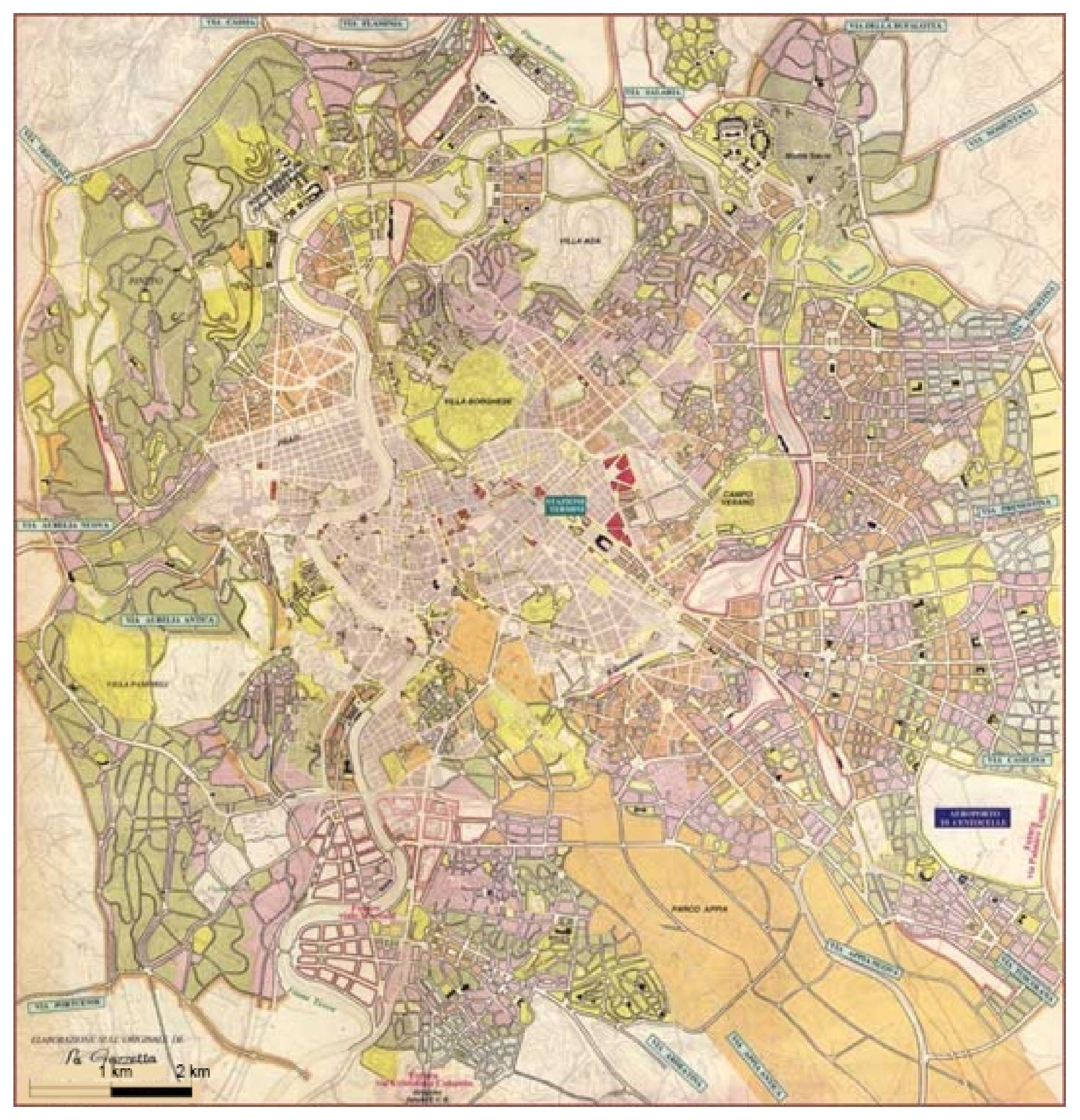
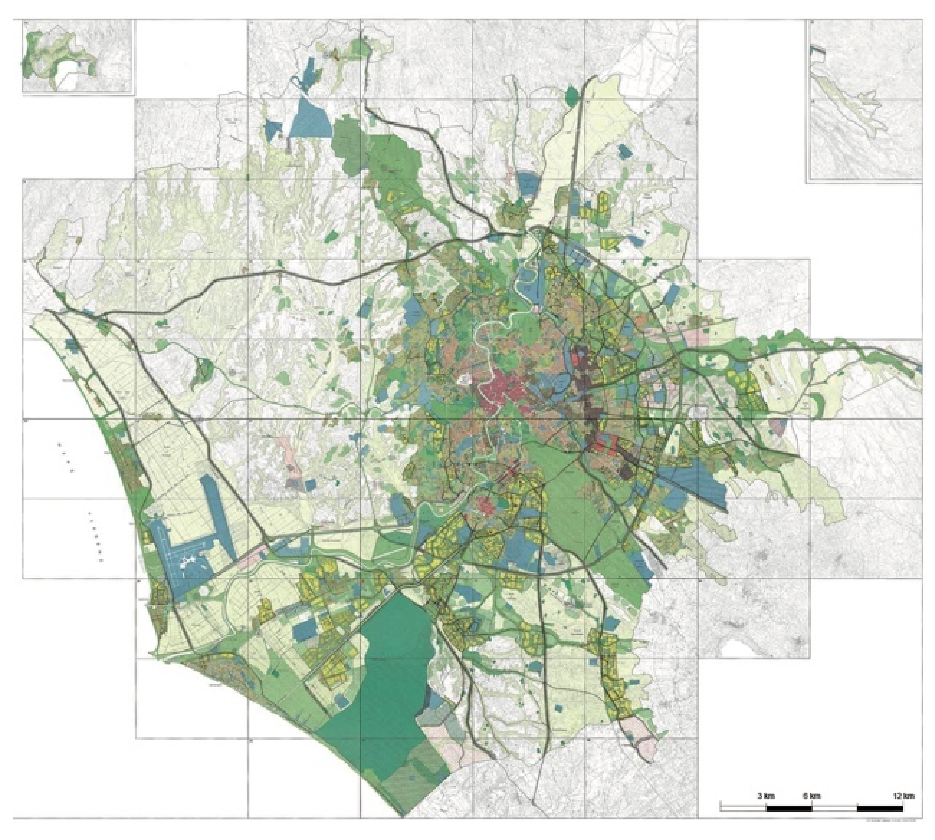
(…) the natural environment has played an important role in conditioning the urban development of Rome, already from the republican era. Later the monuments have often had the effect of preserving green areas, protected from the intense urban development of the last two centuries; these green areas (in particular the large parks of the patrician villas) join the course of the Tiber and therefore the archaeological wedge that develops from the Roman Forum to the Appian Way. In this manner, the whole city is crossed by a green belt that allows faunistic (e.g., for mammals) and also floristic exchanges. Inside the city a sort of urban ecological network is maintained, which is unusual in large European and Mediterranean cities, and which has an important focal point in the archaeological areas.

1.2.3. Networks and Green Corridors as Wellness Infrastructures

Precisely because they participate in the patchwork of terrains vagues and open spaces of the urban fabric, archaeological areas contribute to the making of green corridors that are now highly regarded for citizens’ wellbeing. [17]. These landscapes can be used as networks for soft mobility formed by pedestrian trails and bicycle routes for daily transport [18]. These often-abandoned areas can therefore be transformed into interesting neighborhood spaces, besides infrastructure for sport and leisure, cultural events, relaxation, sustainable mobility, etc.

1.2.4. Enclaves for Sociality and Culture

The city center of Rome is rich in important archaeological sites, much exploited for tourism. Outside the historical center, archaeological sites, even if very copious, are hardly frequented by tourists or citizens. However, these areas can represent an important element of reference for local communities, ensuring a better future for the heritage structures and providing residents with an indispensable sense of belonging [19]. These peripheral sites are often occupied by other abandoned historical artefacts such as nineteenth century forts, farmhouses, mills and factories, offering rich and fascinating conditions. Moreover, these areas, being free, are often used for urban gardens. Urban gardens are more or less large green spaces on the outskirts of the city, they are owned by the municipalities, which give them in management to non-professional growers, who request it. The Urban Gardens are intended primarily for the production of fruit, vegetables and flowers, for the personal use of the grower. These spaces have an important role in the functioning of ecosystems and in providing ecosystems’services, see [20].
Hence, these places can represent a strong social and economic potential for sustainable growth, as public spaces of culture for the practices of reuse and reactivation of sociality. “Third places”, as Ray Oldenburg defined them 20 years ago [21], decisive for the formation and maintenance of civic virtues [22]. Places that could also be defined “infinite” in the sense expressed by the display of the French Pavilion in the 16th International Architecture Exhibition of the Venice Biennale [23], where “infinite” meant open to possibilities, non-finite, processual, capable of suggesting new lifestyles, ways of using and sharing space in dialogue with local communities.

1.2.5. Rome and Its Morphology

Hence, these four ecologies—Archaeology, Porosity, Networks and Enclaves—fit well in the city of Rome and its urban morphology, which belongs, as described by Christian Norberg-Schulz [24], on one hand to the world of the “forre”, the tufa hills and gorges of this volcanic region to the west, and on the other to the classical landscape of the Alban Hills to the east. This phenomenological condition describes Rome’s permanent landscape and character, and it was the point of departure for the basic analysis conducted on its territory in our academic design research. Like in any projection, it is necessary to study the predominant features of a place, the potentials to be exploited, and the criticalities to be improved to establish any possible change. Therefore, these four aspects represent at the same time the strengths and the weaknesses of the city from which we departed.

1.3. Rome: New Lifestyles for a More Sustainable City

Rome is a city in Europe with the greatest quantity of green areas per capita, the largest archaeological park, and the highest amount of archaeological sprawl, but at the same time, it is also a western city that suffers from an unsustainable mobility approach, lack of quality of services in the periphery, and an overwhelming impact of tourism. The protected areas form an impressive system that covers 83,000 hectares. It is a green belt with two wedges—the Veio and the Appia Antica parks—that penetrate the building fabric. Nevertheless, this has not translated into a program for uses, culture and sports, or the development of an urban idea that takes advantage of their presence to have a livable and qualified city.
In the last two years, life in cities has been put on hold several times. There were silent streets, empty skies and deserted parks because restaurants, bars, schools, production sites, gyms, cinemas and museums were all closed. We all experienced a new lifestyle suddenly imposed by the COVID 19 crisis. If by chance there was any doubt, the pandemic has shown with sudden acceleration how much the urban context and the environment affect our health. The density of the population, the quality of public space, the transportation systems, the localization of proximity services, the presence of green areas and biodiversity, the relationship with sociality, are all aspects that have an impact on our lifestyles and therefore our health. Health is a human condition that means foremost the absence of illness, but according to a much broader concept established by the World Health Organization, the state of mental psycho-physical well-being as well.
In recent years, urban studies have been focusing on topics that express the need to make metropolises more livable and suitable for outdoor living, in order to encourage citizens to take back public space, administrations to have better ecological wisdom, and all of us to rethink our relationship with the environment. We need to look not only to our health, but also to the health of the ecosystems in which we live. The health approach based on such considerations has been called, for some years now, One Health. One Health is “the collaborative efforts of multiple disciplines working locally, nationally, and globally, to attain optimal health for people, animals and our environment”, as defined by [25]. As WHO explains, it is a question of tackling these problems with a multidisciplinary public health strategy in which different disciplines such as epidemiology, climate science, species protection, environmental risk and sustainable mobility are brought together.
The COVID crisis has shown, with absolute evidence, the distorting effects of current lifestyles on urban areas. The renewed possibility for people to stroll in quiet parks, children to play ball games in the streets, wild animals to return to the cities, and huge tourist flows to be stemmed has made us think that we can change our habits and return to a more balanced lifestyle. The only way to limit these disfunctions and reverse the trend is to modify our ways of inhabiting the planet, which means to reestablish an equilibrium with nature, diversify mobility, rethink tourism strategies, and reinforce residential accommodation in city centers, thereby ensuring stronger benefits from heritage, nature and soft mobility to the more peripheral areas.
For Rome, this means addressing the issue of the quality of contemporary public space. The city is living off its glorious past without being able to tackle a project for the future. In spite of the territory’s potential, problems continue to be dealt with in a sectorial manner. Traffic engineers think about the question of mobility. Archaeologists are concerned with uncovering the vestiges of the past. Biologists deal with biodiversity and ecological network matters. Physicians advocate healthy lifestyles to prevent disease. But all these issues need to be approached jointly, in complex projects that bring specialisms together.
In addition, urban regeneration projects are often focused on individual areas of the city without considering the effect that a single intervention may have on urban structure as a whole. The reasons for these aporias are probably to be found in the outdated and segmented system of city governance.
The role of a project and the task of an architect are precisely this: to try to coordinate different aspects and find a balance between disparate demands. The university’s research, because of the several specializations that cooperate, is able to holistically address issues that can then be realized over time through specific individual projects, as long as they are part of an overall concept. It is, in fact, a matter of providing a vision for the city, which is usually the main shortcoming of our municipal administration. We illustrate in this paper three Roman cases that concern archaeological areas and green spaces, for which we propose a different design approach not only oriented towards the mere preservation of historical and natural places but also aimed at overlapping uses, functions, and the symbolic and social aspects that these areas have to offer. Some of these areas are highly studied from a sectoral point of view. However, none of the studies offer multifaceted readings. We have tried to combine these individual aspects into a single project and a complex vision to be presented at public debates and displayed in exhibitions, serving to stimulate the city’s cultural discussion concerning future strategic issues.

2. Materials and Methods

New ways of planning and designing heritage territories have emerged from the concept of sustainability. Landscape architecture can play a decisive role in the inclusion of these archeological sites in the urban system. Not closed monofunctional places separated from the urban fabric, but green oases with multiple activities and living spaces with services and facilities. Places that are in connection with the city and form part of the urban system. It is in fact crucial for the city of Rome to create systemic actions. The three case studies were therefore selected to ponder not only on the conservation of archaeological sites but also to think of these areas as lively urban places. They are important areas for the surrounding neighborhoods to not only maintain the biodiversity of the natural variety of species but also ensure their functional diversification, and introduce activities of sociality, soft mobility paths, leisure facilities, etc. These three cases are either vast areas or a set of areas to be connected together, which can be proposed as green infrastructures and elements of urban connection. This reflection therefore requires an interdisciplinary approach, capable of capturing the heterogeneity of the issues at stake and providing a strategic vision for the future of the city. The university’s research offers a multidisciplinary approach (we worked with archaeologists, landscape architects, sociologists, economists and botanists) that is able to foster changes in lifestyles and modes of transforming the city with nature-based solutions, a great opportunity to bring about a different enhancement of heritage.
As Marc Schoonderbeek [26] wrote: “The territorial and urban contexts are the primary forces that both influence and determine to a large extent the contemporary production of architectural construct and that the underlying philosophical, cultural, political and aesthetic value systems both influence and determine to a large extent the meaning/significance of architectural production”. In this framework, one of the most important aspects of the research is spatial analysis to inform architectural design, and one of the principal tools used in this respect is mapping to investigate and explore the multiplicity of social constructs and representations. The acts of observation via interpretation to notation are the basic principles of this research process.

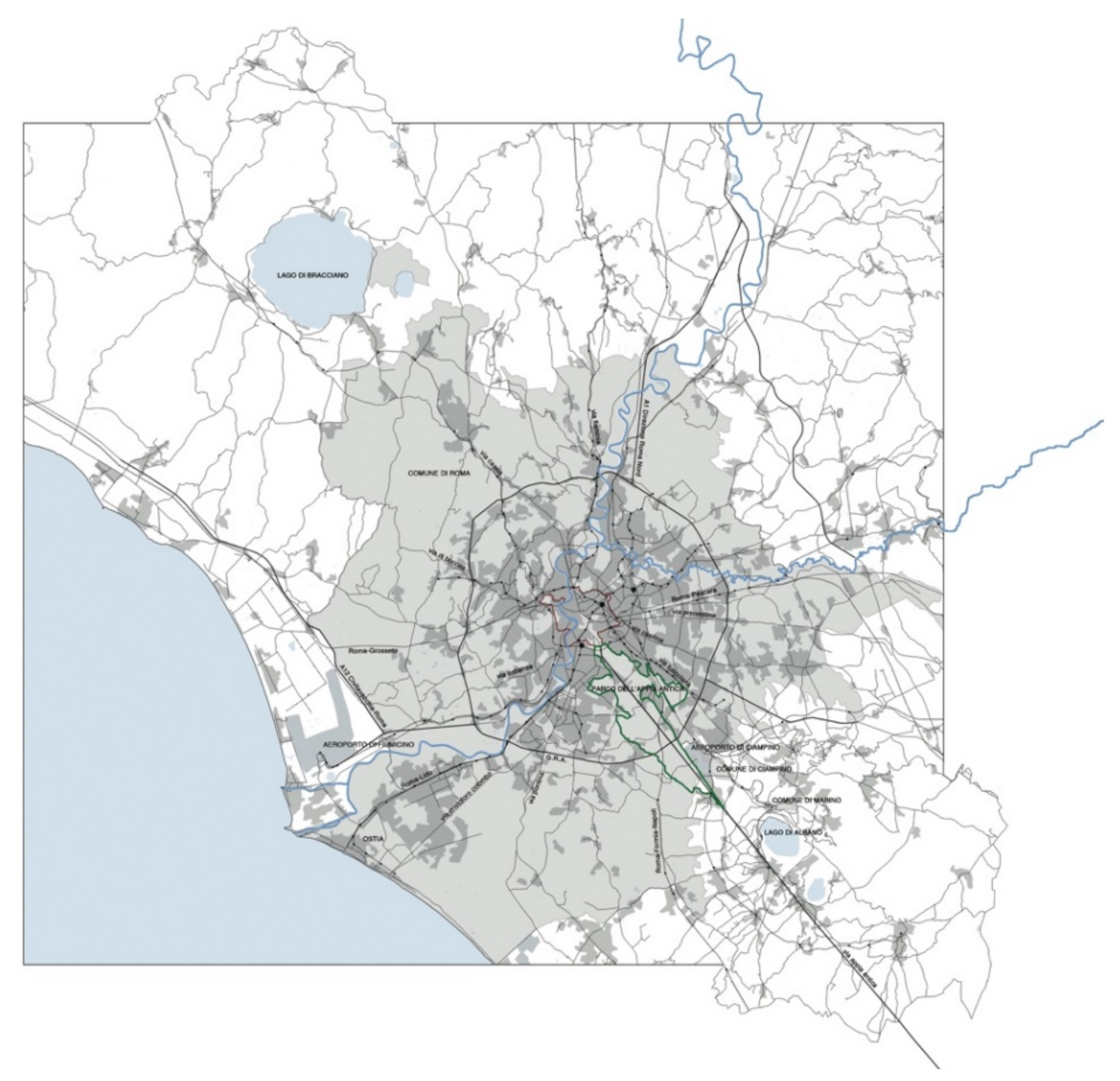
2.1. Three Case Studies in Rome

The Appian Way Park, Rome’s city walls and the ArchaeoGRAB represent three opportunities to propose a systemic approach and a holistic enhancement method through mapping. In the European Cultural Heritage Strategy for the twenty-first century [27], cultural heritage, natural environment and sustainable mobility play a crucial role in building more inclusive and just societies and improving the quality of life and performance of ecosystems [28]. In addition, these projects respond to the principles of the FARO convention in “recognizing the need to put people and human values at the center of an enlarged and cross-disciplinary concept of cultural heritage” and “emphasizing the value and potential of cultural heritage wisely used as a resource for sustainable development and quality of life in a constantly evolving society” [29].
The three studies are currently in different stages of development:
  • The investigation on the Appia Antica Park is part of a national research on archaeological areas in metropolitan contexts, and has matured through on-site visits and data collection, archival research, public conferences, design workshops, students’ thesis, theory seminars, and work sessions to produce interpretative maps. The research was developed in parallel, following the same research methodology in two other case studies: the University of Napoli progressed on the archeological area of Campi Flegrei, and the University of Siracusa on Piazza Armerina [30]. The results of these investigations are compiled in four books [8,31,32,33].
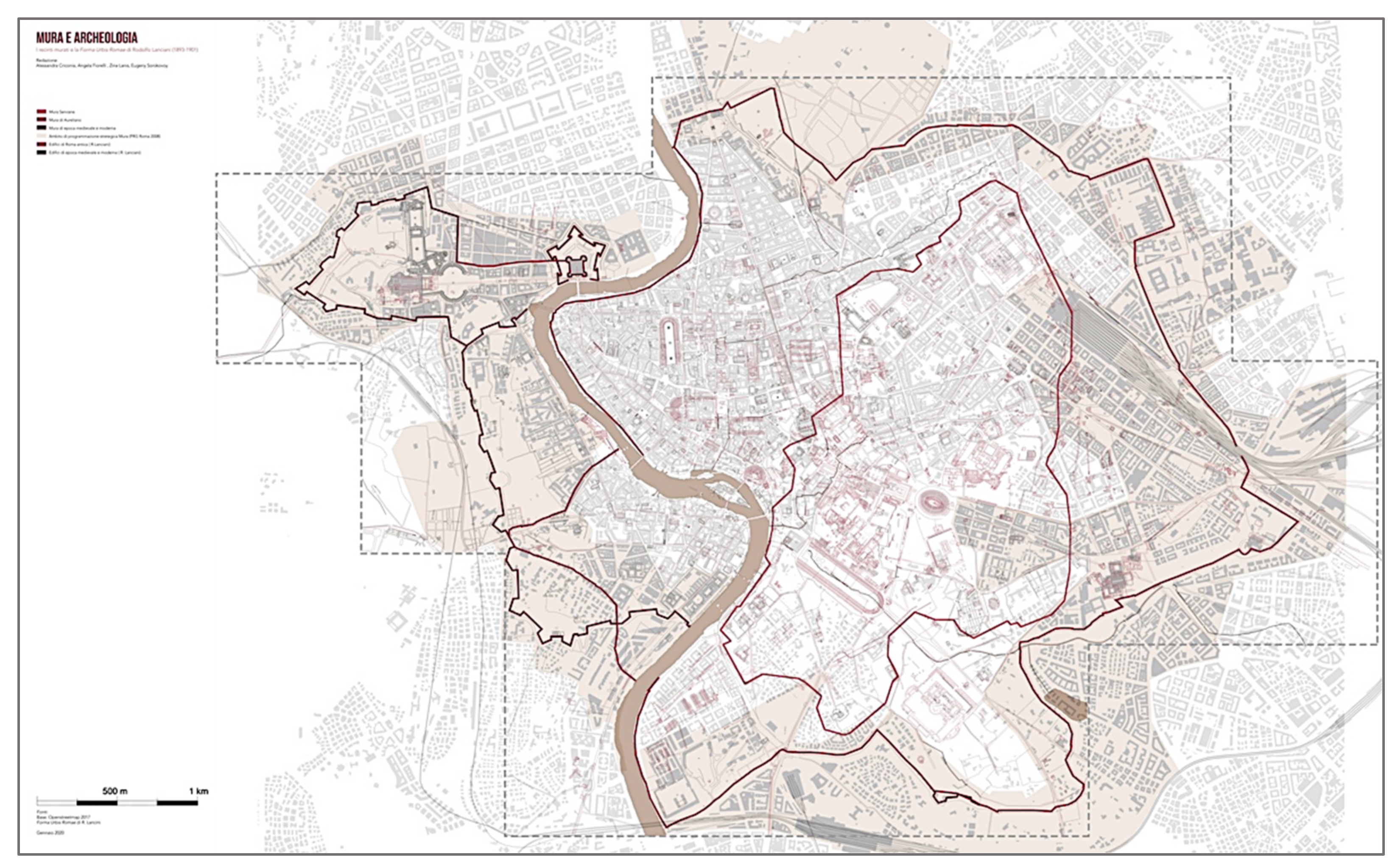
  • The study on Rome’s city walls [34] is ongoing. The research team is operating in thematic groups. Dialogue and interaction are provided through theoretical seminars and design workshops actively involving significant actors (administrators, citizens’ associations, foundations) towards concrete prospects of social, economic and administrative feasibility. The research will be compiled in a publication titled “The Walls of Rome. An ecological and cultural infrastructure for the contemporary city”.
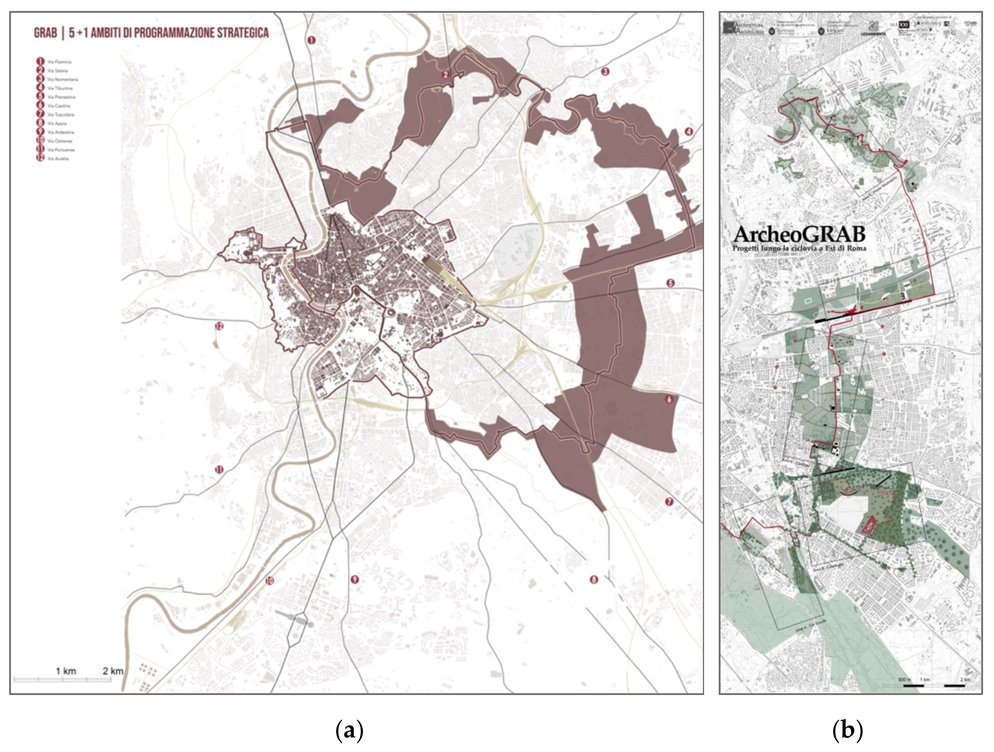
  • The research on the ArchaeoGRAB [35] is starting, and so far, has produced a design workshop and preliminary study seminars. An exhibition at the Galleria Nazionale di Arte Moderna in Rome and publications are under development.
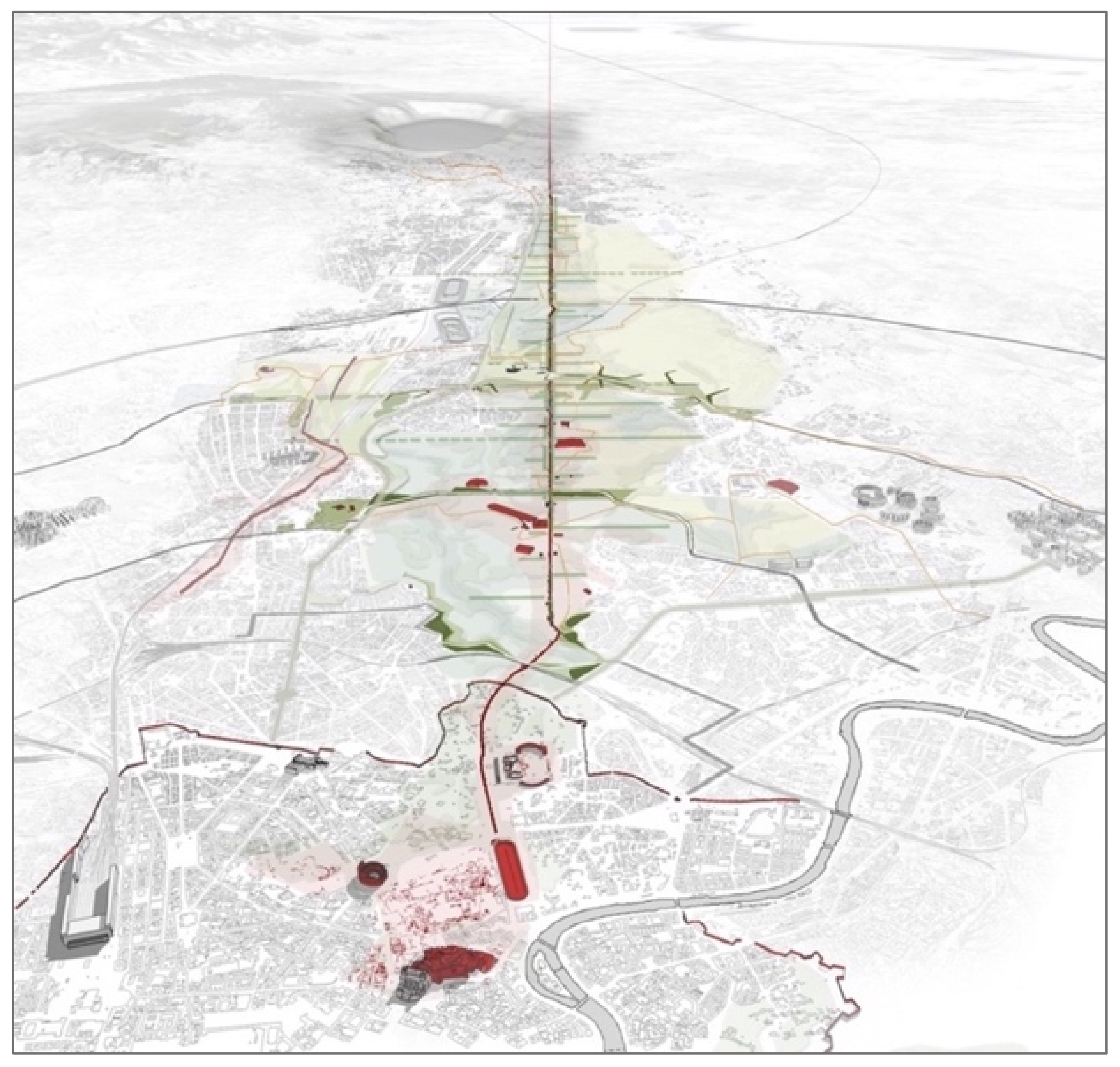
We briefly describe the three case studies.
  • The Appian Way Park
The Antique Appian Way Regional Park was established in 1988, around the first consular road of the Appia Antica. More recently, in 2016, the Ministry of Cultural Heritage identified the Appia Antica Archaeological Park to protect the archaeological remains around the ancient road as a whole, and not only as individual monuments. This vast area of more than 4500 hectares is crucial for the city of Rome in terms of its identity, history, imaginary and environmental quality. It is an area that has been extensively studied for its heritage, being one of the favorite destinations of the Grand Tour, but also for its indubitable environmental and ecological qualities that have remained intact thanks to archaeology and the fact that actions to preserve it were put in place since the time of Pope Paul III Farnese. However, these studies usually had a single-disciplinary focus.
Our research has instead tried to put in relation the different environmental and cultural aspects of the Appia Antica Park in the context of the metropolitan area of Rome, attempting to consider them in a holistic prospect for their interaction and reciprocity. Above all, the research, which has a proactive and projectual character, sought to place the Appian Park in the future perspective of the city, considering it as a cultural and sustainable resource aimed at creating better livability for Rome and the metropolitan area (Figure 1). Although of the three case studies, the Appia Antica is the one that to all intents and purposes is a park, it is considered nowadays more as a tourist destination than environmental infrastructure for the city that can be used for cycling, achieving connections between parks, and introducing sport and leisure resources in a systemic vision. Our research wanted to emphasize the unexpressed potential of the Appia Antica park to act as environmental infrastructure at the daily service of the city and an element of connection between the historical center and the area of the Roman castles.
b.
Rome’s City Walls
The walls of Rome are composed of six distinct defensive systems (Mura Romulee, Serviane, Aureliane, Leonine, Vaticane, Gianicolensi) developed over the centuries, from the city’s origins until the seventeenth century, that are still largely visible today. Rome, in fact, is the only European capital to have preserved almost entirely the circuit of its walls and gates. This research’s aim is to reconnect Rome’s wall system and the Central Archaeological Area to the city’s vital circuits in order to build complex infrastructure that can generate new cultural and historical meanings, and encourage urban accessibility and innovative functions for citizen activities and tourism in ecological, pedestrian, cyclable and social inclusion terms.
Different disciplines are involved within the same intervention strategy. The city’s walls and the Fora area are considered simultaneously as: (1) Historical–archaeological infrastructures capable of supporting new excavation and documentation campaigns; (2) Ecological infrastructures able to connect and enhance the network of green spaces, envisioned as precious pools of biodiversity and environmental comfort; (3) Urban infrastructures, intended as multiple, complex spaces that involve different scales of the architectural project, suggesting new public and collective uses, such as sustainable mobility; (4) Infrastructures of technological innovation, proposed as labs for experimenting with new techniques and technologies specialized for cultural heritage; (5) Infrastructure of imaginary, conceived as spaces that can communicate the extraordinary stratification of literary, cinematographic, pictorial, photographic and design images.
The walls, in their double nature of monuments and material texts, are the object of thematic investigations to understand their role from the past to the future. In the hypothesis of the re-establishment of the entire “walkability” of the walls’ circuit at the top and in the reservoir that surrounds them, a new “breathing space” is designed. The goal is to develop a linear park meant for accessibility to the areas and the permeability through the monuments. This green infrastructure will weave new urban routes and public spaces generated in relation to the needs of the city: the walls, as cultural and environmental infrastructure, become a ring park and an open-air museum of the city for the enhancement of all the cultural and archeological activities (Figure 2) that are connected to this system.
c.
The ArchaeoGRAB
The GRAB (Grande Raccordo Anulare Biciclette) is an annular bicycle path proposed by Legambiente that develops for 44 km connecting spontaneous routes frequented by cyclists (Figure 3a). This ring is an opportunity not to be missed to offer alternative mobility for daily use, and not only for touristic or leisure purposes. Most importantly, the GRAB is an occasion to use it not just as a track but make it the triggering element of a profound transformation of Rome, considering how it traverses a territory full of historical and environmental richness that is partially in a state of emergency and neglect.
Our research is studying the potential of this path, which we have renamed ArchaeoGRAB (Figure 3b) because of the abundance of archaeological remains. We envision it as a complex infrastructure that can generate new cultural meanings and encourage healthy lifestyles through surgical interventions aimed at re-functionalizing the entire urban system. Nature, heritage, housing, social services and mobility can build a unified whole, involving different goals in the intervention strategy.
The ring develops westward, mostly along the existing Tiber bicycle track, and eastward in the unbuilt territories of the so-called “Asse Attrezzato”, or Eastern Directional System (SDO), an urban sector never realized and dedicated in the 1962 Masterplan of Rome to the relocation and expansion of the administrative structures of the capital in the form of a central business district. The oversized provisions of the masterplan as well as the presence of archaeology determined the abandonment of these terrains. Nowadays, this leftover porosity represents a potential wealth.
In 2017, within the Sapienza University Master in Architecture for Archaeology, we developed a design workshop identifying five sites in Tor Fiscale, Centocelle, Casilino, Serenissima and Ponte Mammolo, with the aim of enhancing, in a holistic vision, historical and natural heritage, and developing an urban regeneration program of public spaces, as well as promoting soft mobility. The municipality of Rome was invited to participate in the educational experiment. In 2020, the Town Planning Department prepared a path of confrontation and participation with the citizens and both public and private operators for the sharing of objectives and for defining adequate tools for the implementation of a General Arrangement Scheme of the so-called Green Ring to be developed in ex-SDO areas and around the railway loop [36]. On the basis of four major objectives, namely (1) Environment and climate change; (2) Intelligent and alternative mobility; (3) City gates; and (4) “Zero balance” development, the city administration fixed specific goals concerning intermodal mobility (railway ring and bicycle tracks), refurbishment of the squares in front of the main railway stations as gates of access to urban space, replanning of the four districts of the Eastern Directional System (Pietralata, Tiburtino, Casilino e Centocelle-Quadraro) from the perspective of protection and enhancement of the historical and environmental system, the redevelopment of open spaces, the provision of proximate services, and the widespread regeneration of existing building stock.

2.2. Methodologies

For these three landscape projects, similar methodologies are applied. The scientific method adopted is a body of techniques for investigating phenomena and acquiring new knowledge, as well as for correcting and integrating previous comprehension concerning these areas. It is based on gathering observable, empirical and measurable evidence, subject to the principles of reasoning. The collection of scientific data and social matters were combined and balanced to obtain responses that can address users’ needs. As in all design proposals, the process is complex: part of the answer is based on rational data that need to be interpreted, another part needs instead to be a creative outcome based on compositional capacity and poetics. In addition, “the orchestration between art and science involves discipline in both the lateral and linear thought processes. Lateral thinking utilizes analogies and links ideas across a spectrum to create something imaginative. Linear thought is a step-by-step ideation that keeps us grounded and leads to a specific result. In architecture, as in music, to compose is to order different elements. As with music, in architecture, the art of composing is the art of knowing how to “construct”: constructing form is the objective of compositional activity. All the procedures and techniques that are adopted during composition assume an “aesthetic” value and function, if they are able to order the elements such that the “whole” has a form and a meaning.
In our case study, factors such as scarcity of resources, uncertainty about future scenarios, and the need to act quickly to improve the quality of life of the peripheral areas suggested that we proceed not with large but small mending interventions. So, our philosophy was to act through sewing operations that propose low-cost solutions, and are open to additional future transformations such as healthy corridors for slow mobility, implementation of “third places”, reuse of existing buildings, and networking. Possible strategies of regeneration were therefore imagined for mapping existing elements and potentials of the territory that needed be connected and enhanced. Most of the resources are already present, but they need to be known. Grounded on these assumptions, the projects were developed in three phases:
Phase 1/Expansion and integration of knowledge
To be carried out through surveys, collection of existing data, compendium of projects and publications, interviews with experts.
  • Retrieving and recomposing the fragmented territory.
These territories are full of interesting structures, services and activities that, however, act individually and not as part of a system. Therefore, the first operation to be carried out is primarily one of identification of information and data collection. The understanding of the topography and the data concerning the conservation and use of archaeological and historical heritage, as well as the identification of the environmental potentials and criticalities of the context (evaluation of the biodiversity, connectivity, environmental efficiency and comfort, resilience for climate adaptation, landscape legibility, walkability and existing cycling paths and capacity) are at the base of these studies. More specifically, data collection of:
  • cartographies (historical, updated, ecological networks, land covers, uses, etc.);
  • historical images;
  • photographic campaign to explore the current image of the territory;
  • survey of criticalities and potentials of the area examined;
  • interviews to understand collective needs, lifestyles;
  • systematization of the collected data on a georeferenced basis.
b.
Documentation Regarding Existing National and International Integrated Programs and Pilot Projects (Healthy Corridors, Slow Mobility and Heritage).
Monitoring of national and international initiatives that can serve as best practices to inspire interventions:
  • on healthy corridors, green mobility and regeneration of public spaces;
  • on tactical urbanism, flexible interventions on public space;
  • on cultural itineraries and eco-tourism;
  • on the «post-COVID-19 city»;
  • on the reuse of existing buildings.
Phase 2/Pilot Projects
To be carried out through critical analysis, discussion with local authorities, identification of strategies, workshops and mapping, and design activities.
c.
Analyzing the urban dynamics that can be triggered by the rehabilitation and integration of infrastructural systems.
Paths, natural environment, archaeological remains and abandoned buildings are a composite morphology that can be reconnected through the construction of new cycle and pedestrian paths and the realization of public spaces. The creation of sports and play activities and the facilitation of community initiatives can establish new geographies of movement and active life in the city, more linked to the so-called local centralities. These areas are in fact a system of public spaces identified by the Rome 2003 General Master Plan, and are considered as “the driving forces behind the local social identity around which to organize the qualification processes of the many “cities” in which Rome is recognized, through the enhancement of existing public services and spaces and the creation of the missing centrality”. The project took into consideration:
  • thematic studies to understand current and future social dynamics;
  • identification of alternative strategies.
d.
Selection of specific areas and goals to implement pilot projects.
In connection with local authorities and organizations, the aim of the research was to identify concrete strategies and areas to develop specific landscape designs to be carried out through workshops:
  • meetings with heritage superintendencies, archaeological sites, municipalities, environmental organizations, transportation bodies;
  • meetings involving local communities and associations operating in the area to discuss strategic objectives;
  • detection of the interventions and their capacity to build thematic networks;
  • elaboration of interpretative maps and schemes;
  • synthesis of data collected to develop design ideas.
Phase 3/Dissemination
The main spreading tools are: conferences, workshops, educational activities, exhibitions and publications. The three case studies taken into consideration are at different stages of development. Therefore, dissemination is still an ongoing process, of which this article is a part.

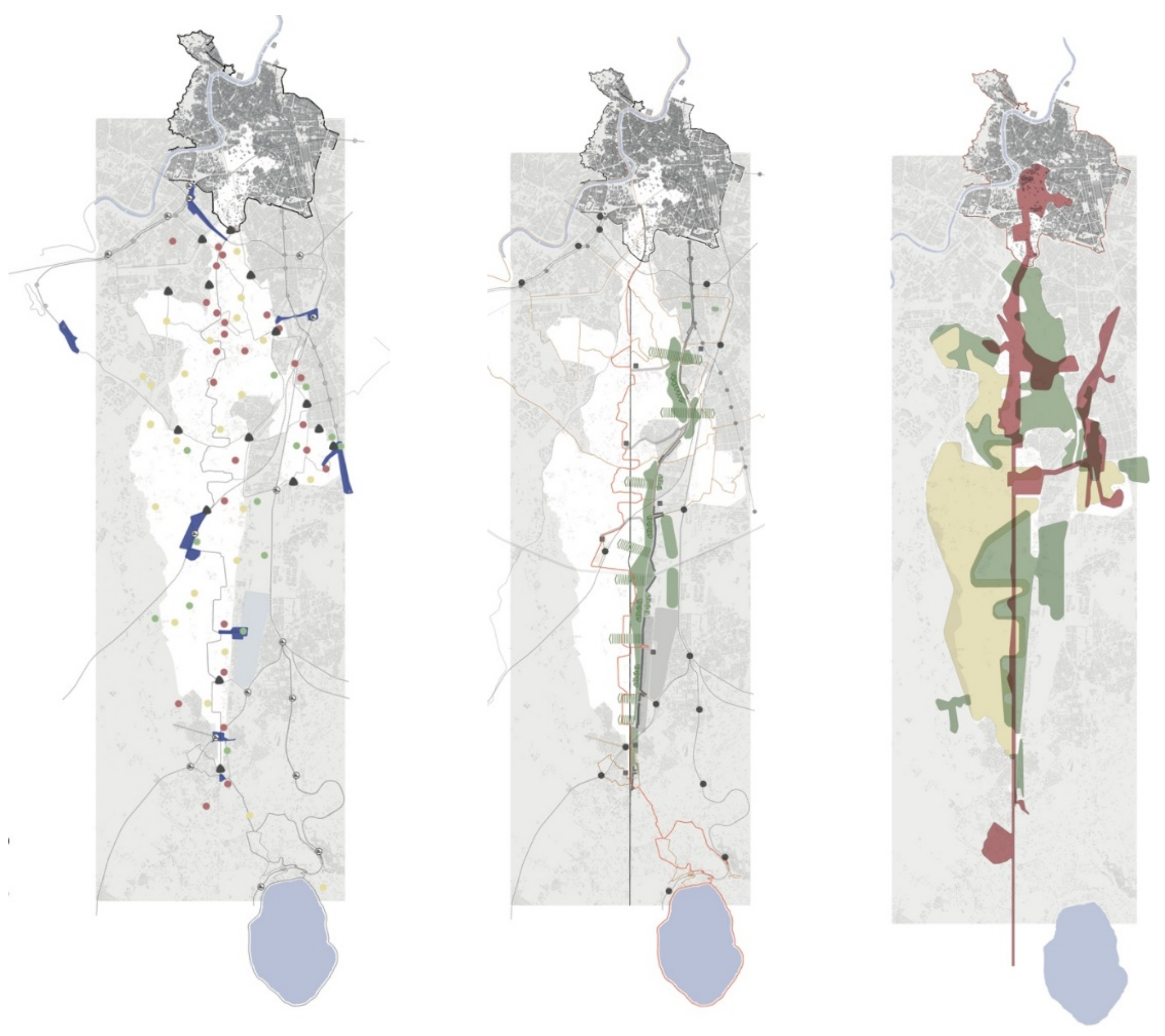
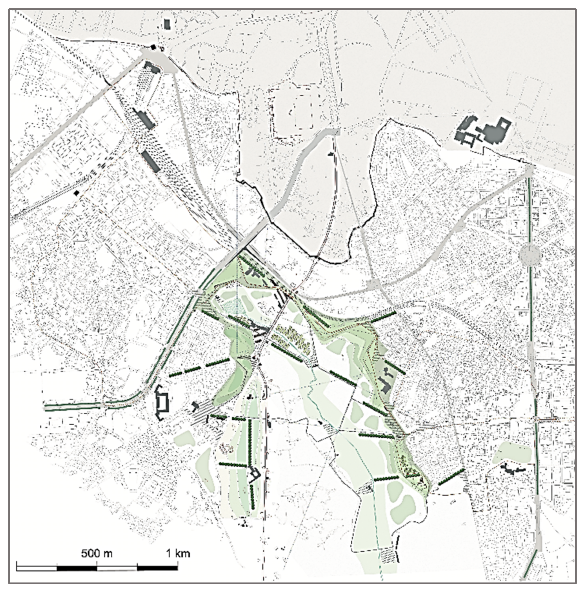
3. From the Road to the “Superpark”: A Project for the Appian Way

This section of the article focuses on the Appia Antica, with the aim of partially retracing and disseminating in English the results of the published research and in particular the history of the area and the role that the past can play in the future of the city.

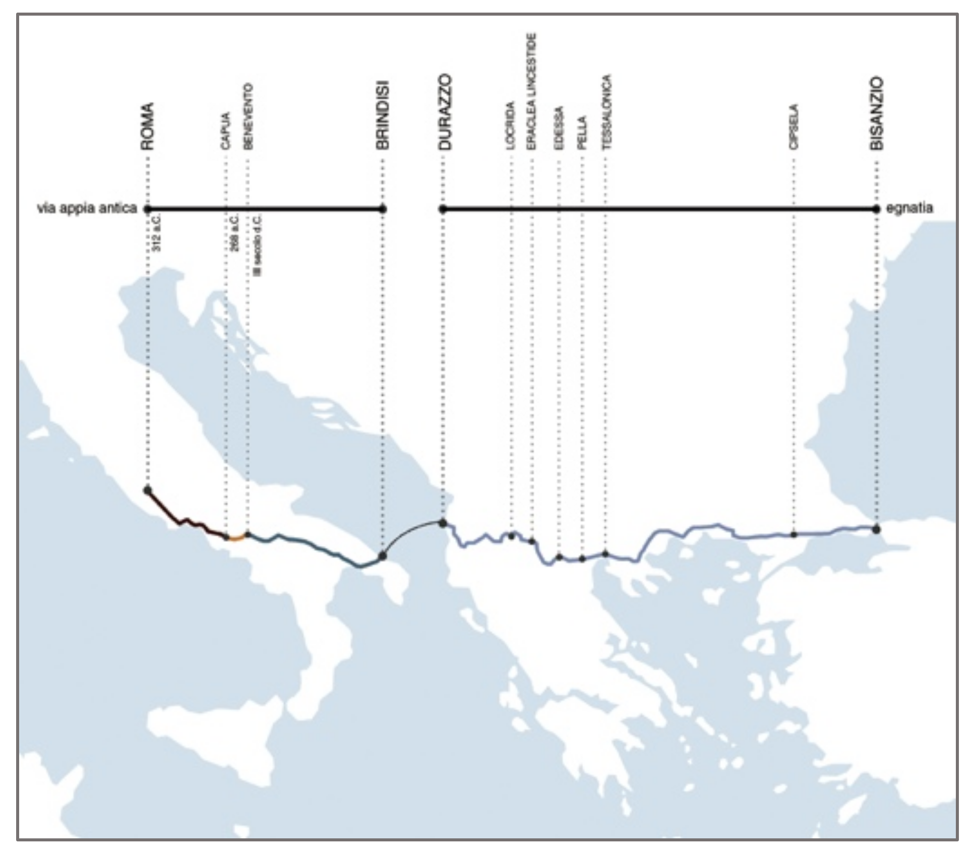
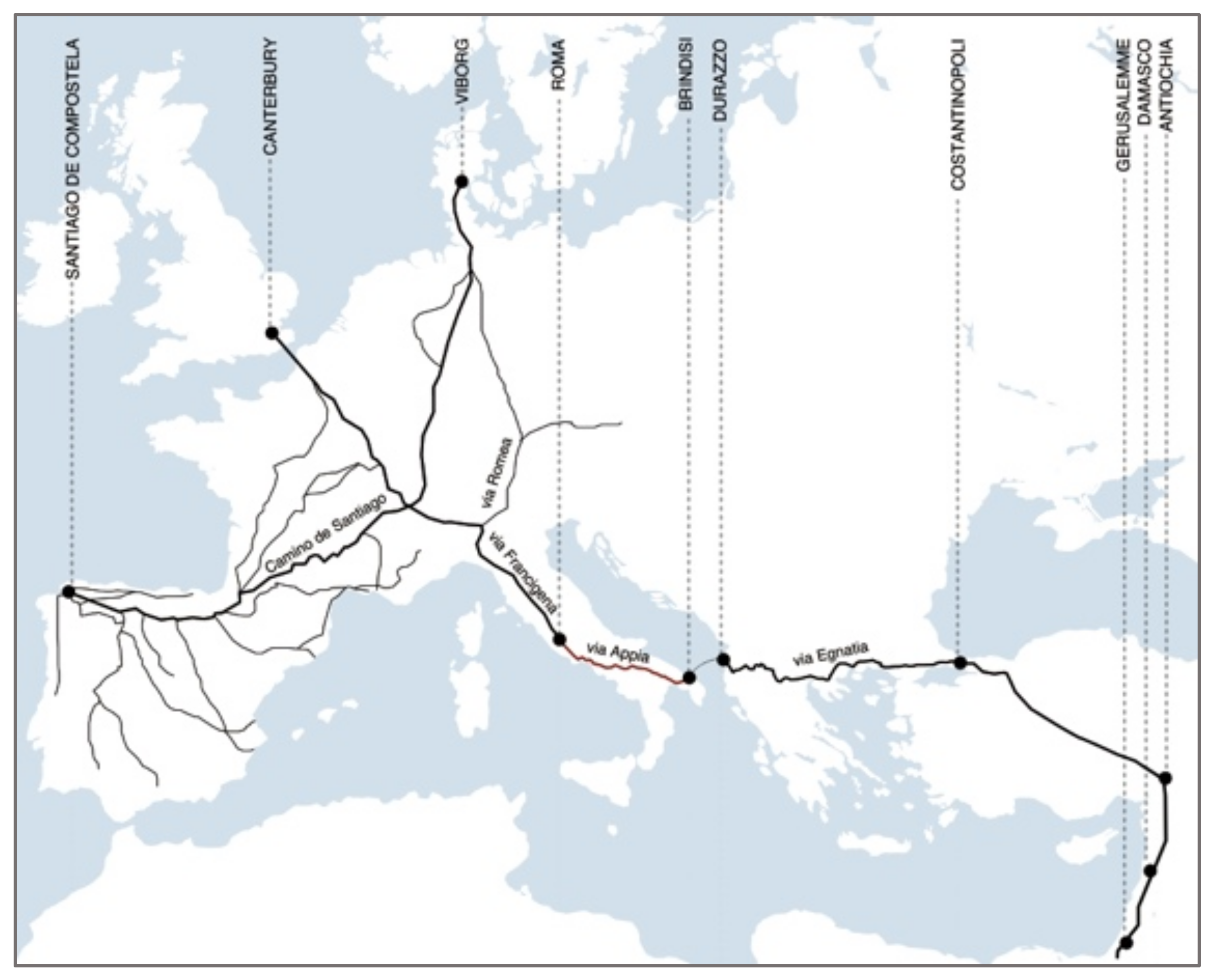
3.1. Historical Elements

The regional park located between the Tiber plain and the Lazio Volcano is named after the Via Appia Antica (see Figure 4).
The street was built in 312 BC by the censor Appio Claudio, who also constructed the first aqueduct of Rome, two structures which were part of a vast program of territorial equipment that still strongly characterizes this metropolitan area. An impressive straight line was built by exploiting the morphological conditions of the territory, made by the formidable underlayment of the lava flow of the Lazio Volcano. The Appia has always had a structuring and representative role. For the Romans, the road was a territorial project that marked the domain of that civilization in a physical and symbolic way. Built initially up to Capua, it was then extended to Brindisi to become, by crossing the Ionian Sea, the Via Egnatia, the main connection to Byzantium (see Figure 5).
Later, during the medieval period, the Appia was part of the Via Francigena, a pilgrimage network of routes that connected to the main holy places of Santiago de Compostela, Rome and Jerusalem (see Figure 6). The Appia was also the main access to the city for the triumphal entry of Charles V in Rome, after the conquest of Tunis. A symbolic axial arrival much celebrated by Paolo III Farnese, who undertook for that occasion a grandiose program of preservation of some important monuments along the way. The road crossing the southern part of the Roman Campagna became iconic and paradigmatic at the time of the Grand Tour, the study trip that scholars and artists of the European aristocracy undertook since the seventeenth century in Italy and Greece, the cradle of the ancient classical civilizations. To testify to the persistent importance of the road, there is cartography from the first half of the seventeenth century focusing on the Appia’s linear extension and the buildings along it.
At the time of Napoleon, Camille de Tournon, the prefect of Rome, started a reconnaissance campaign of the area with the idea of promoting restoration and enhancement of the main Roman consular road, commissioning to Antonio Canova to start archaeological excavations. From the Campidoglio to the Appia Antica, a vast park would have surrounded the area of the Fora and the Colosseum: a project that aimed to adapt Rome to the new role of the second imperial French capital, a city with large green spaces that responded to modern criteria of representativeness and beauty, as well as hygiene (see Figure 7).
At the end of the nineteenth century, this intervention stimulated the creation of an archaeological promenade between Porta Capena and Porta S. Sebastiano and aspired to recompose the urban and extra-urban sections of the Via Appia. In the same period, Gustavo Giovannoni began his studies on the new city masterplan, welcoming the proposal formulated by Marcello Piacentini two years prior, in 1916 (see Figure 8), to form a Ring of Parks and to consider the unity and intangibility of the archaeological area. The latter was to be welded to a ring of parks and gardens that surrounded the city and, in particular, connected to the urban stretch of the Appia Antica and to the “romantic” system of green spaces immediately outside the Aurelian Walls.
The 1931 Master Plan takes up the Napoleonic idea of a park and the subsequent Piacentini propositions (see Figure 9). A large wedge-shaped area fits into the southern fabric, joining with the archaeological promenade and the Fora area. Mapped as a “zone of respect”, it is the first act for the establishment of a “huge park including all the vast area dotted with antiquities and whose axis is the ancient Appian Way”. The 1962 Master Plan allocated more than half of this area to a public park, but also granted the construction of approximately two-and-a-half million cubic meters (see Figure 10). Thus, the public park vocation had definitely matured, but the policy of compromises was also established, making it clear that the implementation of the Appia Park wasn’t without obstacles. Antonio Cederna, archaeologist, journalist and environmentalist ante litteram, denounced the assets of vandalism or decadence of the heritage on the territory and conducted a strong battle for the establishment of the Appia Antica Park, which finally led to a large archaeological protected area in the center of Rome in 1979 meant to be connected with that of the Appia Antica. In 1988, the Appia Antica Regional Park was finally established, and 10 years later, a park authority was put in charge of its management. The Culture Ministry established in 2014 a few archaeological parks and museums of relevant national interest, endowed with special autonomy (scientific, financial, accounting and administrative), among which the Appia Antica Archaeological Park was also identified [37,38]. This coexistence of institutions running in the same area obviously created management difficulties. For what concerns the Municipality of Rome, the 2003 Master Plan defines the so-called Strategic Areas, five unitary systems that structure the city, two of which have naturalistic contexts: the Tiber and the Appian Way.

3.2. The Appia Antica Park as a Park of the 21st Century

The identification of the five Strategic Areas was the most innovative and interesting part of the 2003 plan. It placed the Appia Park in the right crucial dimension for the city. But no action followed this choice, specifying a real project for the park. What is evident is that there is not yet a contemporary vision of what this great protected area should be for the city of Rome and its future. Starting from the 1931 Master Plan, that is to say from the inclusion of the area in a protected legislation, the only evident concept developed is that of being a safeguarded area. Renato Nicolini wrote in 2011 that the Appia Antica Park is “a paradox… because it presents the maximum symbolic values and, at the same time, the evident depression of its actual use“. How can we live—wondered Nicolini—in an area of the city that preserves the memory of the Roman Campagna but still belongs to the contemporary city [39]?
The conservation of this area has been debated since the Napoleonic era, but what role do these 4580 hectares have today in the city’s structure? In recent decades, architecture has gradually abandoned one of its most important and traditional operational fields: the territory that has been uniquely developed through planning and infrastructural engineering tools, disciplines that tend to simplify the complexities by responding to singular objectives. The territories of “continuity”—such is the Appian Way—are those that show characters of “long duration”. Permanencies characterize these landscapes, so the relationship of the territory with time and memory and the interpretation of historical and archaeological signs is of great importance [40]. Landscape architecture can be an interesting tool for governing these processes.
In this vast green area, 85% private and very important in the city ecosystem, archaeology represents one of the components of the context, which is actually heterogeneous. Residential, agricultural and productive areas coexist together with protected natural and cultural heritage. Many of them are qualified hot spots and contribute to the implementation of uses that are indispensable to keep such a vast territory alive. The city of Rome, in about 200 years, has grown intensely around the Appian Way, surrounding the margins of the park established approximately 30 years ago. Today, the area south of Rome represents, as Piacentini had foreseen, one of the most populated areas of the hinterland. The Appian Way Park is therefore at the center of a metropolitan context that gives to the park even more significance. This large “void” is actually the heart of a potential green infrastructure for sustainable mobility, for sport and culture, for urban agriculture, for the provision of services, which could represent an important resource for neighboring districts if linked to the rest of the city’s networks.
As Rosario Pavia [41] has pointed out, the drawing imprinted on the cover of our book [32] (see Figure 11) gives a sense of the role of the park today. It represents, as in a logo, the diagram plan of the Roman metropolitan area. Few signs on the urbanized contour: the two volcanos, the rivers Tiber and Aniene, the coastline, the walls and the Grande Raccordo Anulare (GRA), and the axis of the Appia Antica with the outline of the park. The sign of the Regina Viarum immediately arises as geographical and urban infrastructure, and it is part of the identity of the city since it belongs to the past, affects the present, but, above all, projects into the future the outline of a “concrete utopia” for the city. The Appian Way is basically a unit of measurement, a radius that intersects the rings of the Aurelian walls and the Grande Raccordo Anulare (the motorway that surrounds the city), and goes further into southern territory. Rome, in its disorder, finds in the Appia Antica a geometric and spatial reference: the linearity of the ancient Roman road and the great emptiness of the park both affect the unshaped metropolis, crossing it from the center to the extreme periphery. Looking closely at this artery of the past, it becomes evident that it determines the contemporary city. The Appian Way Park can have a similar role in Rome as Central Park in New York, a park that is at the center of the city, becoming its symbolic and pulsating heart. The enhancement of this great territory must be conceived starting from the connections that it can establish with the surroundings.
The general objective of the research and the landscape project was to make the park, currently closed and introverted and scarcely accessible, an interconnected urban centrality, enhancing its exchanges with the city. We envisaged designing new gates, redefining the margins, and tracing the mobility network to fashion a system of public spaces and equipment located in nodal points. We identified all the important available services already present in the park and we put them in connection.
Our work, therefore, wanted to measure itself with a non-sectorial view, trying to think of the Appia Park as a part of Rome, a place that can be lived and used by its citizens, and become a resource instead of just another tourist destination. The global vision overcomes sectorial projects and acts by systemizing resources, skills and abilities.
Three different systems were identified (see Figure 12):
  • The Points (The Hotspots)
Heritage (Historical and naturalistic)
Knots and Uses (doors/services/park usability)
Relocations (Restoration and transformation)
  • The Lines (The Sustainable Mobility)
Cycle Promenade (from the Aurelian walls to Frattocchie)
Parkway (Via Appia Nuova as a window on the park for accessibility and parking)
The Iron Lines (Railways and subways as privileged connections and gateways)
  • The Surfaces (The Park Landscapes)
Palimpsest (The historical linear landscape)
Loisir (Areas of culture, sport and leisure, and public parks)
Agriculture (The agricultural landscape)
We also redefined the role of transversal roads as specific infrastructures to access the park, and not just high-speed axes for cars as they are nowadays. Three major crossings have a significant and diversified function in equipping the park:
The first passage of Via della Travicella (see Figure 13). aims to strengthen the relationship between the park’s head by the Aurelian Walls and the eastern and western neighborhoods of Appio Latino and Via Cristoforo Colombo, and includes an electric bus rail and a cycle path. This area is conceived as a “gateway” from the city center, with the creation of the “Appia Antica” railway station and a parking area for tourist buses.
The second crossing in Via dell’Almone (see Figure 14). aims to serve the main monumental area with the Catacombs, the Circus of Maxentius, the Mausoleum of Cecilia Metella, and the Villa Capo di Bove. This is the stretch of the Appian Way where Canova’s and Canina’s archaeological installations are located. A light tramway infrastructure, the “Archaeotram”, intercepts the A, B and C lines of the Metro, making the archaeological, monumental and naturalistic areas fully accessible.
The third route, conceived as a parkway on Via di Tor Carbone (see Figure 15). connects the consular roads of Laurentina and Tuscolana, burying twice at the Villa dei Quintili and the Parco degli Acquedotti. The trackline is designed as a device to enjoy the landscape and capture wind energy while gaining access to many agricultural farms.

4. Discussion

Our work has sought to address a few questions, imagining the Appian Way Park as a part of today’s Rome, offering not only touristic attractions but also spaces for Romans to make the most of their everyday life. We also tried to make the Appian Way Park an understandable morphology of the city, one of its structural and recognizable elements. Similarly, we are now working on the city walls and the ArchaeoGRAB, intended as urban systems providing available and usable historical and natural environments as well as clear uniqueness and identity and urban connections.
Preliminary research is a crucial tool that architects master in order to effectively address the technical, aesthetic and behavioral issues that arise in their work. The scientific method we used in these case studies includes understanding the surrounding context from environmental, historic, formal and infrastructural perspectives and determining program areas required by users, such as pedestrian areas, bicycle paths, sports facilities, leisure equipment and museological devices. To work on these diverse aspects, we need to apply a design methodology based on a trans-disciplinary approach, integrating the use of the tools, techniques and methods from various disciplines. Spatial analysis was conducted through the collection of data and mapping interpretations. Design research was frequently based on the observation of best practices. We need synthetic interpretations that suggest uses and capture the identity of places [41].
The principal questions we addressed in these three sites are:
  • Archaeological parks are usually enclosed areas separated from the city fabric although their ruins belong to the palimpsest of the city. What role do we want to give to this specific form of the past nowadays, especially in more peripherical areas?
These places can be occupied and used by citizens, and become a hope for the sustainable future of Rome. Local communities can manage, control and protect their heritage and natural resources, aimed at creating new ecosystems in urban and peri-urban contexts. These places could stimulate social innovation, encourage different lifestyles, motivate creativity, presenting not only opportunities for touristic visits of the ruins but also including different cultural genres and activities.
2.
What kind of infrastructure does the city of the twenty-first century need?
These areas can contribute to the implementation of sustainable mobility, the provision of urban forestry and agriculture, sports facilities for citizens’ wellbeing; they should be rich in biodiversity, and not just in the botanical sense. They are spaces intended for the community, where social alternatives can be expressed. Several studies show that landscape architecture is a highly strategic and operative tool to govern key issues related to the social, sustainable, ecological and environmental aspects of these archaeological sites [42]. It is an indispensable instrument to achieve innovative and effective solutions. As Mueller et al. state: “Landscape research must generate knowledge, innovations and responsible decision rules for achieving these aims. Big data gathering and scenario modelling are important for knowledge generation in a globalized world [4]”.
3.
What actions and strategies do we need in Rome today?
It is the city as a whole at the center of such a program. These projects try to overcome sectorial visions and act by systemizing resources, facilities and spaces.
The goal is to link the fragmented pieces of the territory and the segmented paths of the cycle system, and implement them with renewed spaces in novel circuits. We have tried to bring in a connection with the abandoned or underused voids of the city, still full of biodiversity and heritage richness, and create what we could call a landscaped urbanity. This means putting together existing and new routes, ancient and renovated spaces, in a way that is not unfamiliar in Rome. The whole city is the paradigm of such a palimpsest, and many infrastructures such as the Aurelian Walls and the Via Olimpica were built by reusing fragments of existing structures. The Appia Antica Park, Rome’s city walls and the ArchaeoGRAB represent factors that can turn the capital’s decay into an opportunity for the future.

Funding

These studies were funded by Sapienza University Grants (grant number RG120172B477D20D and grant number RG11816436AC27FA) and Ministry of Education Grant (grant number 2009S9X7M7).

Institutional Review Board Statement

Not applicable.

Informed Consent Statement

Not applicable.

Data Availability Statement

The data presented in this study are available on request from the author.

Acknowledgments

We are grateful to the academic researchers whose teamwork made it possible to develop the three case-studies: (1) For the Appian Way: PRIN 2009, Paesaggi dell’archeologia, Regioni e Città Metropolitane. Strategie del progetto urbano contemporaneo per la tutela e la trasformazione. National Coordinator: Alessandra CAPUANO; Research units: 1. Università degli Studi di ROMA “La Sapienza”, Dipartimento di Architettura e Progetto: “The case-study of the Appia Antica Park in the metropolitan area of Rome”, Principal Investigator Alessandra CAPUANO, 2. Università degli Studi di ROMA “La Sapienza”, Dipartimento di Scienze Storiche, Archeologiche e Antropologiche dell’antichità: “From archaeological ruins to musealization”, Principal Investigator Marcello BARBANERA; 3. Università degli Studi di NAPOLI “Federico II”, Dipartimento di Progettazione Urbana e Urbanistica: “Archaeology as landscape infrastructure: the Campi Flegrei”, Principal Investigator Pasquale MIANO; 4. Università degli Studi “Mediterranea” di REGGIO CALABRIA, Dipartimento di Architettura e Analisi della Città Mediterranea: “Landscape of archaeology, cities and metropolitan regions: Magna Graecia”, Principal Investigator Marcello SESTITO; 5. Università degli Studi di CATANIA, Dipartimento di Architettura, Storia, Strutture, Territorio, Rappresentazione e Restauro e Ambiente: “From the Roman Villa del Casale to the Territorial Park of the Gela River. Strategies for the government of territorial transformations”, Principal Investigator Fausto Carmelo NIGRELLI. (2) For the Aurelian Wall: Sapienza University Research Grants 2018/Large Projects: Roman infrastructure. The urban walls and the central archaeological area in new vital cycles of cultural promotion, technological innovation, socioecological reactivation and new competitiveness for the city of Rome, Principal Investigator Orazio CARPENZANO, team: Alessandra Capuano, Lucina Caravaggi, Alessandra Criconia, Giovanni De Bellis, Mihaela Gavrika, Anna Giovannelli, Cristina Imbroglini, Filippo Lambertucci, Giovanni Ragone, Manuela Raitano, Guendalina Salimei, Alessandra Ten. (3) For the ArchaeoGRAB: Sapienza University Research Grants 2020/Large Projects: ARCHAEOGRAB. Green network for sustainable mobility and public space projects for the enhancement of archaeological and natural heritage in the suburbs of the city of Rome, Principal Investigator Alessandra CAPUANO, team: Stefano Catucci, Alessandra Criconia, Fabio Di Carlo, Laura Valeria Ferretti, Alfonso Giancotti, Anna Giovannelli, Federica Morgia.

Conflicts of Interest

The author declares no conflict of interest.

References

  1. Capuano, A. Habitat romano: La periferia sud. In Roma Città Mediterranea. Continuità e Discontinuità Nella Storia; Terranova, A., Capuano, A., Criconia, A., Feo, A., Toppetti, F., Eds.; Gangemi Editore: Roma, Italy, 2007; pp. 72–95. [Google Scholar]
  2. Banham, R. Los Angeles. The Architecture of Four Ecologies; Harper & Row Publishers: Austin, TX, USA, 1971. [Google Scholar]
  3. Geddes, P. Cities in Evolution: An Introduction to the Town Planning Movement and to the Study of Civics; Williams & Norgate: London, UK, 1915. [Google Scholar]
  4. Mueller, L.; Eulenstein, F.; Mirschel, W.; Antrop, M.; Jones, M.; McKenzie, B.M.; Dronin, N.M.; Kazakov, L.K.; Kravchenko, V.V.; Khoroshev, A.V.; et al. Landscapes, Their Exploration and Utilisation: Status and Trends of Landscape Research. In Current Trends in Landscape Research. Innovations in Landscape Research; Mueller, L., Eulenstein, F., Eds.; Springer: Cham, Switzerland, 2019. [Google Scholar]
  5. Antrop, M.; Van Eetvelde, V. Landscape Perspectives. The Holistic Nature of Landscape; Landscape Series 23; Springer: Dordrecht, The Netherlands, 2017. [Google Scholar]
  6. Antrop, M. Why landscapes of the past are important for the future. Landsc. Urban Plan. 2005, 70, 21–34. [Google Scholar] [CrossRef]
  7. Assmann, J. Cultural Memory and Early Civilization. Writing, Remembrance, and Political Imagination; Cambridge University Press: Boston, MA, USA, 2011; (originally published in 2007). [Google Scholar]
  8. Capuano, A. Paesaggi di Rovine Paesaggi Rovinati; Quodlibet: Macerata, Italy, 2014. [Google Scholar]
  9. Atalay, S.; Clauss, L.R.; McGuire, R.H.; Welch, J.R. Transforming Archaeology: Activist Practices and Prospects; Routledge: London, UK, 2014. [Google Scholar]
  10. Reher, G. Heritage as Action Research. Sustainability 2022, 14, 282. [Google Scholar] [CrossRef]
  11. Fabbri, K.; Ugolini, A.; Canuti, G. A methodology to evaluate outdoor microclimate of the archaeological site: A case study of the Roman Villa in Russi (Italy). Sustain. Cities Soc. 2017, 35, 107–133. [Google Scholar] [CrossRef]
  12. Balletto, G.; Ladu, M.; Milesi, A.; Borruso, G. A Methodological Approach on Disused Public Properties in the 15-Minute City Perspective. Sustainability 2021, 13, 593. [Google Scholar] [CrossRef]
  13. Tadi, M.; Biraghi, C.; Zadeh, M.; Brioschi, L. Urban Porosity. A morphological Key Category for the optimization of the CAS’s environmental and energy performance. J. Eng. Technol. 2017, 4, 138. [Google Scholar] [CrossRef]
  14. Celesti-Grapow, L.; Ricotta, C. Plant invasion as an emerging challenge for the conservation of heritage sites: The spread of ornamental trees on ancient monuments in Rome, Italy. Biol. Invasions 2021, 23, 1191–1206. [Google Scholar] [CrossRef]
  15. Ricotta, C.; Grapow, L.; Avena, G.; Blasi, C. Topological analysis of the spatial distribution of plant species richness across the city of Roma (Italy) with the chelone approach. Landsc. Urban Plan. 2001, 57, 69–76. [Google Scholar] [CrossRef]
  16. Lucchese, F.; Pignatti, E. La vegetazione nelle aree archeologiche di Roma e della Campagna Romana. Quad. Bot. Ambient. Appl. 2009, 20, 3–89. [Google Scholar]
  17. Ashworth, G.J. In Search of the Place-Identity Dividend: Using Heritage Landscapes to Create Place Identity, Sense of Place, Health and Quality of Life; pp. 185–199. Available online: http://www.muf.co.uk/ahorsestale/2008 (accessed on 13 December 2013).
  18. Canto Moniz, G.; Ferreira, I. Healthy Corridors for Inclusive Urban Regeneration. Rass. Archit. Urban. 2019, 158, 51–59. [Google Scholar]
  19. Ashworth, G.J.; Graham, B.J.; Tunbridge, J.E. Pluralizing Pasts: Heritage, Identity and Place in Multicultural Societies; Pluto Press: London, UK, 2007. [Google Scholar]
  20. European Commission. Toward a Green Infrastructure for Europe. Developing new concepts for Integration of Nature 2000 into the Wider Countryside. 2010. Available online: https://ec.europa.eu/environment/nature/ecosystems/docs/green_infrastructure_integration.pdf (accessed on 24 January 2022).
  21. Oldenburg, R. The Great Good Place: Cafes, Coffee Shops, Bookstores, Bars, Hair Salons, and Other Hangouts at the Heart of a Community; Da Capo Press Books: New York, NY, USA, 1989. [Google Scholar]
  22. Lasch, C. La Conversazione e le Arti Civiche. In La Ribellione delle Élite; Feltrinelli: Milano, Italy, 2001. [Google Scholar]
  23. Encore Heureux; Delon, N.; Choppin, J.; Eymard, S. Infinite Places. Constructing Buildings or Places? Editions B42: Paris, France, 2018. [Google Scholar]
  24. Norberg-Schulz, C. Genius Loci. Paesaggio, Ambiente, Architettura, Documenti di Architettura; Electa: Milano, Italy, 1979. [Google Scholar]
  25. One Health Initiative Task Force (OHITF), 2021. One Health Commission. Available online: https://www.onehealthcommission.org/en/why_one_health/what_is_one_health/ (accessed on 24 January 2022).
  26. Schoonderbeek, M. Theory of “Design by Research”; Mapping Experimentation in Architecture and Architectural Design. Ardeth 2017, 1, 63–79. [Google Scholar] [CrossRef]
  27. Recommendation of the Committee of Ministers to Member States on the European Cultural Heritage Strategy for the 21st century (Adopted by the Committee of Ministers on 22 February 2017 at the 1278th Meeting of the Ministers’ Deputies). Available online: https://rm.coe.int/16806f6a03 (accessed on 24 January 2022).
  28. Nieto, M.J.T.; Roura, F.I.; Garcia, J.M.R.; Puentes, E.R. The Galician Archaeological Heritage Network. In Landscapes as Cultural Heritage in the European Research, Proceedings of the Open Workshop, Madrid, Spain, 29 October 2004; Consejo Superior de Investigaciones Cientificas: Madrid, Spain, 2006; pp. 133–144. [Google Scholar]
  29. Council of Europe. Council of Europe Framework Convention on the Value of Cultural Heritage for Society; Council of Europe Treaty Series—No. 199; Council of Europe: Faro, Portugal, 2005; 9p, Available online: https://rm.coe.int/1680083746 (accessed on 24 January 2022).
  30. PRIN 2009, Paesaggi dell’Archeologia, Regioni e Città Metropolitane. Strategie del Progetto Urbano Contemporaneo per la Tutela e la Trasformazione. Available online: https://prin.mur.gov.it/Ricerca?Filtro.Anno=%25&Filtro.Ateneo=Universit%C3%A0+degli+Studi+di+ROMA+%22La+Sapienza%22&Filtro.Argomento=&Filtro.Cognome=CAPUANO (accessed on 24 January 2022).
  31. Capuano, A.; Carpenzano, O.; Toppetti, F. Il Parco e la Città. Il Territorio dell’Appia nel Futuro di Roma; Quodlibet: Rome, Italy, 2013; pp. 1–312. [Google Scholar]
  32. Capuano, A.; Toppetti, F. Roma e l’Appia. Rovine Utopia Progetto; Quodlibet: Macerata, Italy, 2017. [Google Scholar]
  33. Miano, P.; Izzo, F.; Pagano, L. I Campi Flegrei. L’Architettura per i Paesaggi Archeologici; Quodlibet: Macerata, Italy, 2016. [Google Scholar]
  34. Sapienza University Research Grants 2018/Large Projects: Roman Infrastructure. The Urban Walls and the Central Archaeological Area in New Vital Cycles of Cultural Promotion, Technological Innovation, Socioecological Reactivation and New Competitiveness for the City of Rome. Available online: https://web.uniroma1.it/dip_diap/dipdiap/ricerca/ricerche (accessed on 24 January 2022).
  35. Sapienza University Research Grants 2020/Large Projects: ARCHAEOGRAB. Green Network for Sustainable Mobility and Public Space Projects for the Enhancement of Archaeological and Natural Heritage in the Suburbs of the City of Rome. Available online: https://bandiricerca.uniroma1.it/sigeba/#/proposte/2235823/view (accessed on 24 January 2022).
  36. Resolution of the Capitoline Junta, n. 143 July 17, 2020, Approvazione dello Schema di Assetto Generale dell’Anello Verde, a Valere Quale Atto-Strumento di Indirizzo Programmatico per la Riqualificazione Sostenibile dell’Anello Ferroviario e del Settore Orientale del Territorio di Roma Capitale. Available online: https://www.urbanistica.comune.roma.it/anello-verde.html (accessed on 24 January 2022).
  37. DM 44 23/01/2016 Reorganization of the Ministry of Cultural Heritage and Activities. 2016. Available online: http://www.regioni.it/news/2016/03/14/d-m-23-01-2016-riorganizzazione-ministero-beni-culturali-e-turismo-448487/ (accessed on 24 January 2022).
  38. DM 198 09/04/2016 Dispositions Regarding Archaeological Areas and Parks and Institutes and Places of Culture of Relevant National Interest Pursuant to Article 6 of Ministerial Decree 23 January 2016. Available online: http://pompeiisites.org/wp-content/uploads/Decreto-ministeriale-9-aprile-2016-n.-198-1.pdf (accessed on 24 January 2022).
  39. Nicolini, R. Il paradosso del Parco dell’Appia. In Il Parco e la Città. Il Territorio Storico dell’Appia nel Futuro di Roma; Capuano, A., Carpenzano, O., Toppetti, F., Eds.; Quodlibet: Rome, Italy, 2014; p. 101. [Google Scholar]
  40. National Conference “I Territori dell’Architettura”, 31 May–1 June 2019. Available online: https://www.unica.it/unica/it/news_notizie_s1.page?contentId=NTZ172929 (accessed on 22 January 2022).
  41. Pavia, R. Questo Parco s’ha da Fare, Oggi Più che Mai. Commento al libro di Alessandra Capuano e Fabrizio Toppetti; (Città Bene Comune); Casa della Cultura: Milan, Italy, 2019; Available online: https://www.casadellacultura.it/887/questo-parco-s-ha-da-fare-oggi-piu-che-mai (accessed on 22 January 2022).
  42. Latini, L.; Matteini, T. Manuale di Coltivazione Pratica e Poetica. Per la Cura dei Luoghi Storici e Archeologici nel Mediterraneo; Il Poligrafo: Padova, Italy, 2017. [Google Scholar]
Figure 1. The area of the Appia Antica from the Aurelian Walls to the Vulcano Laziale, with the scheme of the equipped traversal system for the functions of the park. A. Capuano, F. Toppetti with D. Luca, A. Lanzetta and F. Morgia, E. Tomassini. Drawing by the research team, reprinted with permission from Ref. [32]. Copyright 2022 Quodlibet Editore.
Sustainability 14 03180 g001
Figure 2. The area of the Rome’s City Walls and the archaeological areas. Drawing by the research team.
Sustainability 14 03180 g002
Figure 3. The area of the GRAB in (a) a general plan of Rome (Drawing by the research team, reprinted with permission from Ref. [32]. Copyright 2022 Quodlibet Editore) and (b) a detail of the Masterplan of the ArchaeoGRAB developed during the Master in Architecture for Archaeology workshop in 2017.
Sustainability 14 03180 g003
Figure 4. The Regional Appia Antica Park and the city of Rome in the Tiber plain. We can perceive the straight line of the Appian Way. Interpretative map of the region. Drawing by the research team, reprinted reprinted with permission from Ref. [32]. Copyright 2022 Quodlibet Editore.
Sustainability 14 03180 g004
Figure 5. The Appian way reaching Byzantium through the Egnatia road. Reprinted with permission from Ref. [32]. Copyright 2022 Quodlibet Editore.
Sustainability 14 03180 g005
Figure 6. The Appian way as part of the circuit of the via Francigena, pilgrim’s way. Drawing by the research team, reprinted reprinted with permission from Ref. [32]. Copyright 2022 Quodlibet Editore.
Sustainability 14 03180 g006
Figure 7. L.M. Berthault, Plan of the Capitol Garden, 1813. From the Campidoglio to the Appia Antica, a huge park would have surrounded the area of the Forums and the Colosseum. Reprinted with permission from Ref. [32]. Copyright 2022 Quodlibet Editore.
Sustainability 14 03180 g007
Figure 8. M. Piacentini, Project of the Ring of Parks in Rome, 1916. Reprinted with permission from Ref. [32]. Copyright 2022 Quodlibet Editore.
Sustainability 14 03180 g008
Figure 9. Rome Masterplans of 1931. Reprinted with permission from Ref. [32]. Copyright 2022 Quodlibet Editore.
Sustainability 14 03180 g009
Figure 10. Rome Masterplans of 1962. Reprinted with permission from Ref. [32]. Copyright 2022 Quodlibet Editore.
Sustainability 14 03180 g010
Figure 11. The cover of the book by A. Capuano and F. Toppetti, Roma e l’Appia. Rovine Utopia Progetto, with the diagram of the Appia Antica Park in the metropolitan context of the city. Drawing by the research team, reprinted with permission from Ref. [32]. Copyright 2022 Quodlibet Editore.
Sustainability 14 03180 g011
Figure 12. The three different systems that characterize the Appia Antica Park: Points/Hotspots, Lines/Mobility, Surfaces/Landscapes. Drawings by the research team, reprinted with permission from Ref. [32]. Copyright 2022 Quodlibet Editore.
Sustainability 14 03180 g012
Figure 13. The first transversal connection on Via della Travicella. Drawing by the research team, reprinted with permission from Ref. [32]. Copyright 2022 Quodlibet Editore.
Sustainability 14 03180 g013
Figure 14. The second transversal connection on Via dell’Almone. Drawing by the research team, reprinted with permission from Ref. [32]. Copyright 2022 Quodlibet Editore.
Sustainability 14 03180 g014
Figure 15. The third transversal connection on Via di Tor Carbone. Drawing by the research team, reprinted with permission from Ref. [32]. Copyright 2022 Quodlibet Editore.
Sustainability 14 03180 g015
Publisher’s Note: MDPI stays neutral with regard to jurisdictional claims in published maps and institutional affiliations.

