
Groundwater in Crisis? Addressing Groundwater Challenges in Michigan (USA) as a Template for the Great Lakes

 , , ,
, , , 
Abstract
:1. Introduction
2. Summit Description and Methodology
3. Results
3.1. General Findings
3.1.1. Scientific Issues
- Groundwater budgets: there is a pressing need for better information on aquifer recharge and withdrawals throughout Michigan, but especially in regions where groundwater pressures already exist or are anticipated to soon become worse.
- Contamination: this concern has been highlighted and exacerbated recently by the discovery of PFAS in many groundwater systems, but it has been an issue for decades with other pollutants such as excess nitrate from fertilizer applications, excess phosphorus from septage, and trichloroethylene from manufacturing processes [34], as well as other human-produced contaminants from commercial and manufacturing operations and processes.
- Forecasting: although we must gain a better understanding of the current state of Michigan’s groundwater, we also need to envision the future state of supply and demand. This has multiple considerations, including, but certainly not limited to, the potential impacts of climate, land use/cover, and demographic shifts that may change withdrawal and recharge rates [35,36]. These factors can influence and exacerbate the movement of pollutants lurking in the groundwater (those already known), as well as those not yet discovered.
- Connectivity: the notion of hydrologic connectivity was a consistent thread in our discussions with respect to both surface water and groundwater. Concerns were expressed about the public’s general lack of understanding of this concept, as well as the lack of geological information regarding connectivity because of limited three-dimensional (3D) geologic mapping in many areas.
- Information Tools and Gaps: these two issues are related, as we have significant information gaps on the 3D extent of glacial aquifers, aquifer water budgets (see above), and groundwater quality, but conveying this complex, technical information in an intuitive and easily digestible manner is equally difficult. Increased efforts to complete 3D mapping of the geologic substrata, as well as other visualization tools will allow us to share complex information efficiently, display information effectively, and communicate the information intuitively. Although better information and science is a critical step forward, it does little good without effective decision-support systems and information/visualization tools.
3.1.2. Management-Oriented Issues
- Public Education: anecdotal evidence suggests there is a substantial portion of society that perceives groundwater as vast pools of “underground lakes and rivers”; there is a pressing need to better educate the public, including elected officials, on groundwater science. The W.K. Kellogg Foundation, in association with the Institute of Water Research at Michigan State University, developed the Groundwater Education in Michigan (GEM) Program in 1987. This program demonstrated that successful source water protection programs must be persistent and depend upon strategic partnerships among federal and state agencies, universities, local and district health departments, watershed groups, conservation districts, and others. Similar efforts need to be reconstituted and maintained into the future.
- Water Use Conservation: how do you convince the Michigan public to conserve water, whether it be from the surface or ground, when they are surrounded by four of the largest lakes on the planet and live in a state with over 10,000 inland lakes? This conundrum was termed the “fallacy of universal ubiquity” by one of the summit participants.
- Land and Water Management: although “conservation” frequently refers to reductions in the use of groundwater, the term may apply also to practices that benefit keeping or maintaining groundwater in the system, including multiple agricultural and urban best management practices (cover crops, green infrastructure), as well as legal mechanisms that restrict development or land use change in high groundwater recharge areas. The benefits of such practices must continually be documented, and subsequently, incentives for implementation will need to be established.
- Environmental Justice: there was an acknowledgment that important segments of our society were not represented at the summit, including representatives from BIPOC communities. Clearly, this limits the scope of our findings and recommendations but highlights that additional efforts, strategies, and capacities are needed to engage with, and understand, this issue from multiple perspectives.
- Advocacy: considerable discussion was devoted to the need to lobby more effectively on behalf of groundwater. This “Sixth Great Lake” [37] deserves increased attention, but there was no clear consensus on how this should be accomplished, especially given the mix of NGO, academic, and government actors at the summit. Each of these groups has perspectives that in some way must comport with their institutions’ guidelines and codes of conduct. However, there was general agreement regarding the need for more effective strategies to garner the resources and attention on groundwater as a growing Great Lakes issue. A few of the ideas that were discussed included: (1) using the GLRI (Great Lakes Restoration Initiative) to create a new Focus Area devoted to groundwater or the Great Lakes Water Quality Annex (GLWQA) Annex 8 update; (2) an annual MI conference devoted to groundwater (although concerns were expressed about preaching to the choir); (3) conducting a study estimating the economic value derived from groundwater use in the state through the agricultural, manufacturing, drinking water, etc. sectors; and (4) utilizing the Water Use Advisory Council as a vehicle for greater advocacy.
3.2. Groundwater in the Agricultural Sector
3.2.1. Key Challenges
- (1)
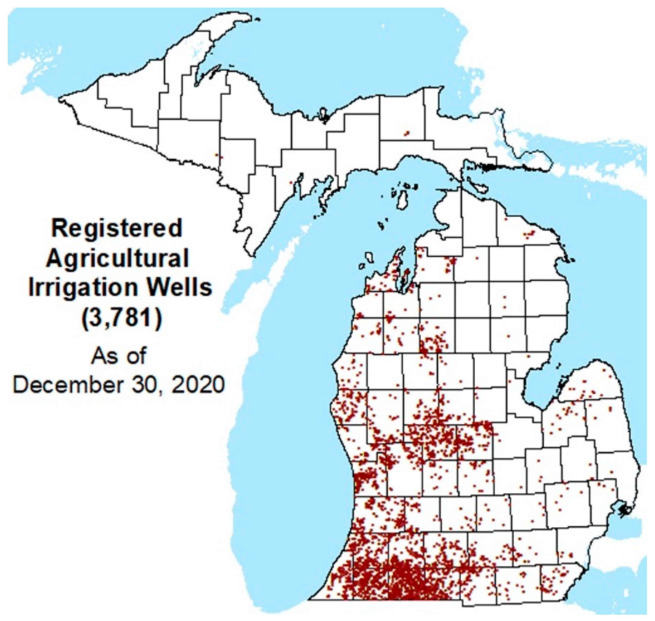
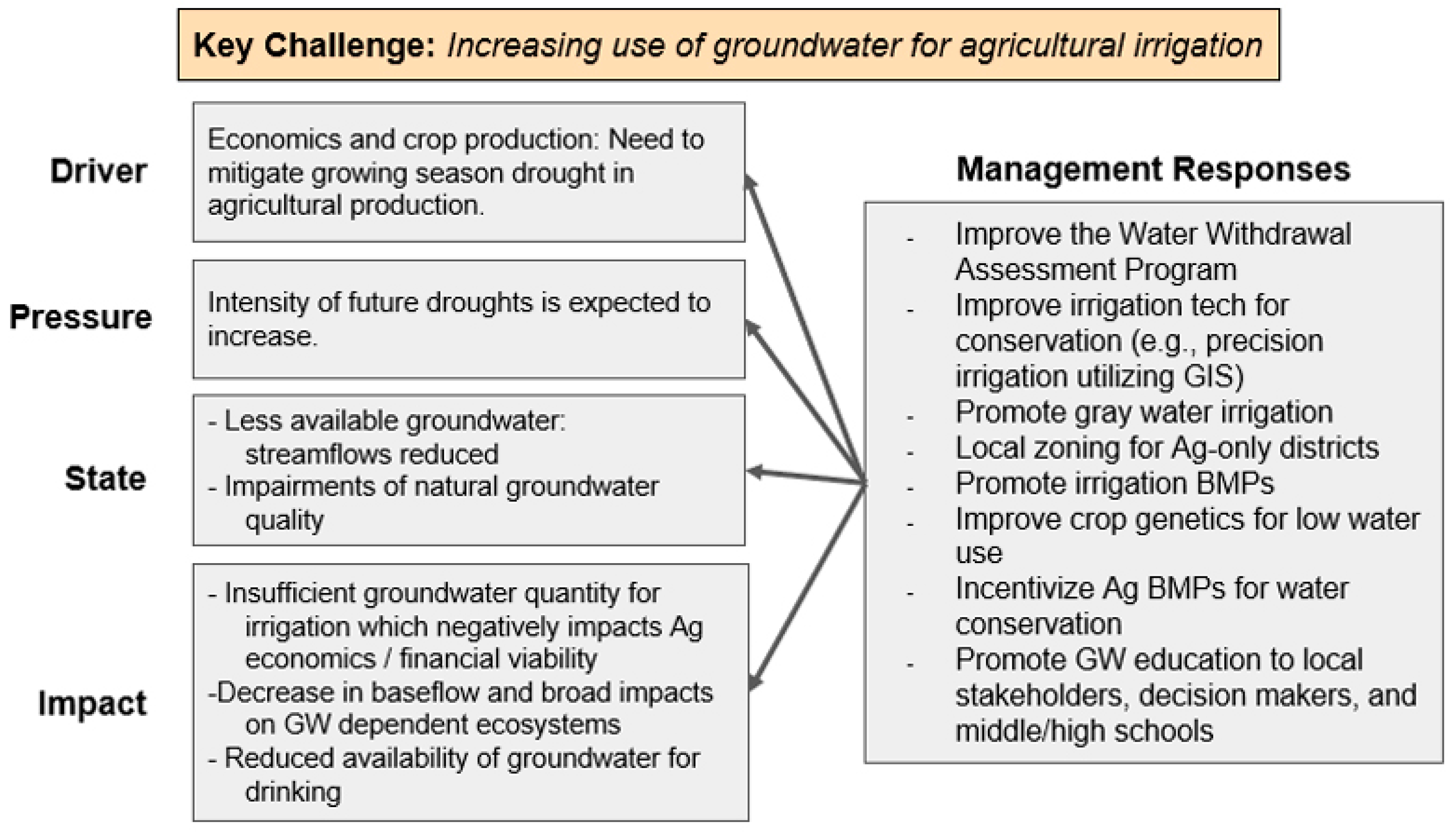
- The increasing use of groundwater for agricultural irrigation—the need to irrigate, primarily using groundwater sources, has dramatically increased in Michigan over the last two decades. Between 1997 and 2017, the amount of irrigated cropland in Michigan expanded by ~51,175 ha—a 64.6% increase [40,41]. In the period 2008–2020, the number of agricultural irrigation wells in Michigan more than doubled, increasing by 152% [38,42,43]. Over 3600 high-capacity agricultural irrigation wells have been developed in Michigan over the past decade (Figure 1). The irrigation sector (dominated by agriculture) withdrew an average of 154.3 MGD (million gallons per day) of groundwater in 2010 and 208.5 MGD in 2019 [14,44], and questions are being asked about sustainability [45].
- (2)
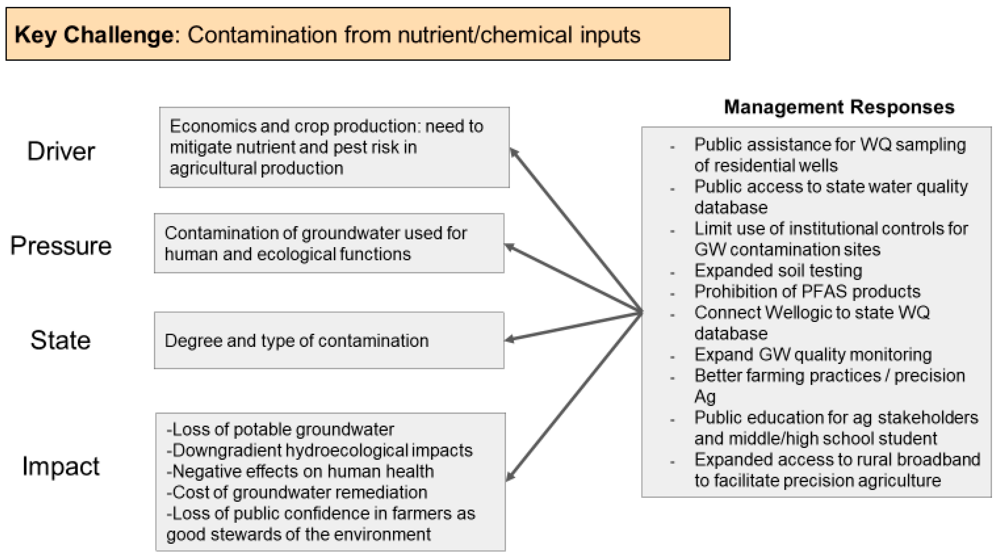
- The increasing contamination of groundwater from agricultural nutrients and chemicals—fertilizer use in Michigan increased steadily from the 1930s, when commercial fertilizers first became available, to the early 2000s when total consumption of fertilizers in Michigan leveled off [46]. According to USEPA [47], the amount of N fertilizer purchased in Michigan in 2007 contained 243.6 million kg of N. The longer-term trend shows an 8% decrease in N fertilizer sales in Michigan, comparing 2002–2006 with 2007–2011 [47]. Virtually all agricultural commodities produced in Michigan require treatment with pesticides to prevent serious yield losses from disease and insect, nematode, vertebrate, or weed pests [48].
- (3)
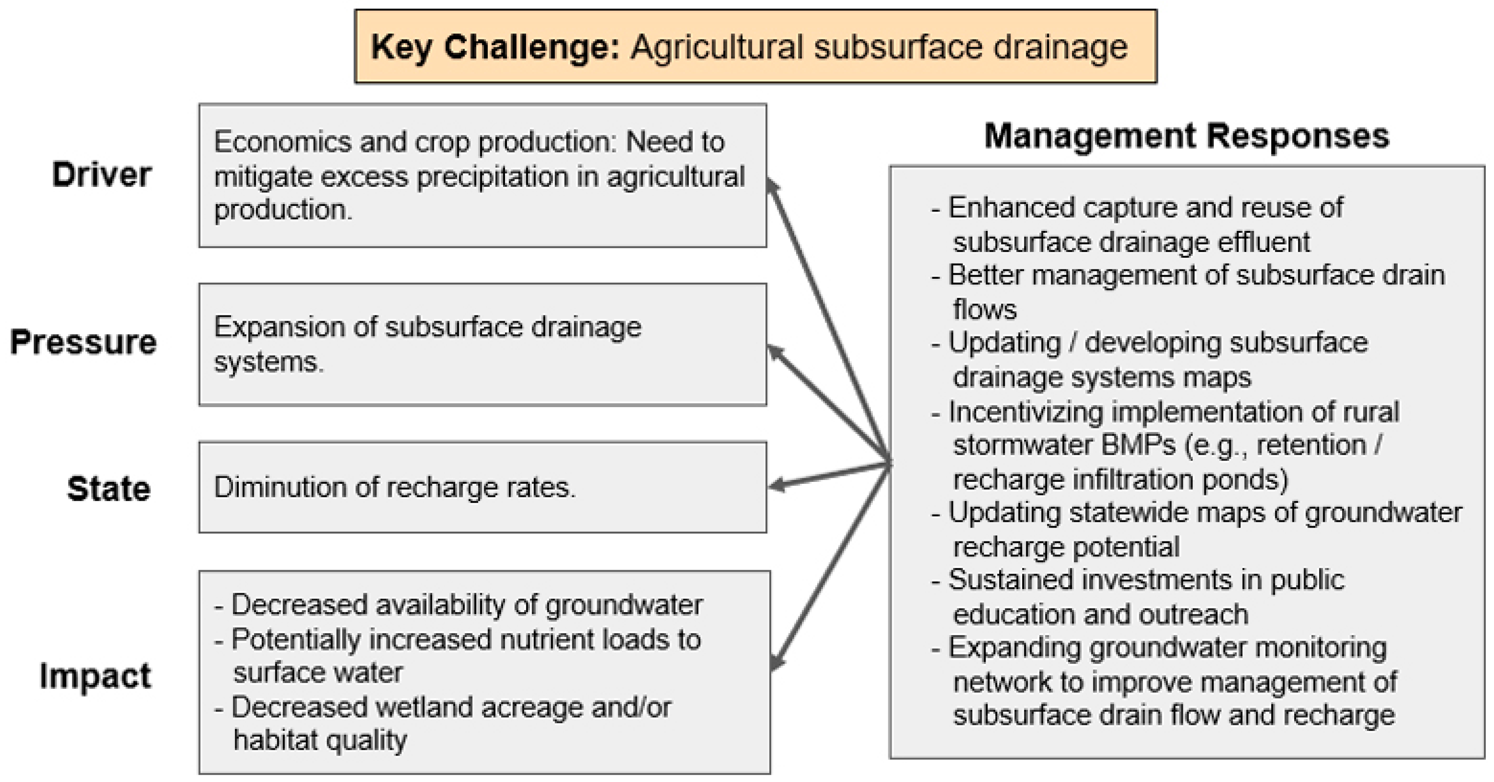
- Groundwater Recharge and Drainage Best Management Practices (BMPs)—in general, agricultural producers deal with excessive soil moisture nine months out of a year, with the remaining three months committed to irrigating crops during periods of limited precipitation. Although traditional practices of subsurface drainage have proven successful in reducing excessive soil moisture, thereby creating optimal conditions for crop production, a detrimental impact of such practices is a decrease in groundwater recharge [49]. Subsurface drainage systems, in general, transport surplus water in the soil’s root zone to surface drainage ditches, and ultimately into rivers and lakes. Over time, this removal of water from agricultural fields negatively impacts localized groundwater recharge rates, resulting in a decline in available groundwater from shallow aquifers, and also contributes to downstream eutrophication [50,51].
3.2.2. DPSIR Models
Groundwater and Irrigation Model
- Improve the Michigan Water Use Program and the Water Withdrawal Assessment Tool by funding and implementing the recommendations of the Water Use Advisory Council [30]; see below.
- Improve the efficiency of low-loss irrigation technology and conservation measures.
- Promote precision irrigation technologies utilizing GIS and in-situ monitoring.
- Advocate for gray water irrigation technologies and adoption.
- Improve local zoning by adopting “ag only” zones and open space uses of regional groundwater recharge areas.
- Incentivize the widespread adoption of irrigation BMPs [58].
- Advocate for enhanced research funding of drought-tolerant/low-water-use crop genetics.
- Promote and sustainably fund groundwater education to local stakeholders, decision-makers, and middle/high school students.
Groundwater Contamination Model
Groundwater Recharge and Drainage Best Management Practices (BMPs)
3.2.3. Discussion
Policy and Practice
- Develop techniques to recycle/reuse drain tile water and residential gray water;
- Advance precision agriculture, including the enabling conditions such as expanding soil testing and expanding access to broadband;
- Assess local and state ordinances as well as regional planning efforts that protect and conserve groundwater;
- Employ new approaches to improving irrigation efficiencies; and
- Connect Wellogic to the state water quality database to increase consistent and accessible data.
Science and Infrastructure
- Assess groundwater connectivity, with a focus on movement of groundwater from one system to another;
- Update statewide groundwater recharge maps;
- Develop and/or update tile drain maps;
- Assess groundwater changes via techniques such as calibrating GRACE (https://grace.jpl.nasa.gov/applications/groundwater/ (accessed on 4 February 2022)) to the Great Lakes region;
- Invest in core development of precision irrigation, broadband availability, real time collaborative monitoring networks, and use of satellite imagery to guide agricultural practices; and
- Assess the benefit of agricultural best management practices for groundwater quality and quantity.
Education and Outreach
- Continued communication with and among the agricultural community on groundwater issues, especially utilizing farmer-led watershed groups;
- General education with the public (i.e., where does your water come from?);
- Training for water well drillers for consistency to improve the accuracy of lithology data;
- Improve/develop new water conservation programming through existing programs like MAEAP or others; and
- Stronger and more intentional engagement between various governmental, academic, NGO and business communities.
3.3. Groundwater in the Urban Sector
3.3.1. Key Challenges
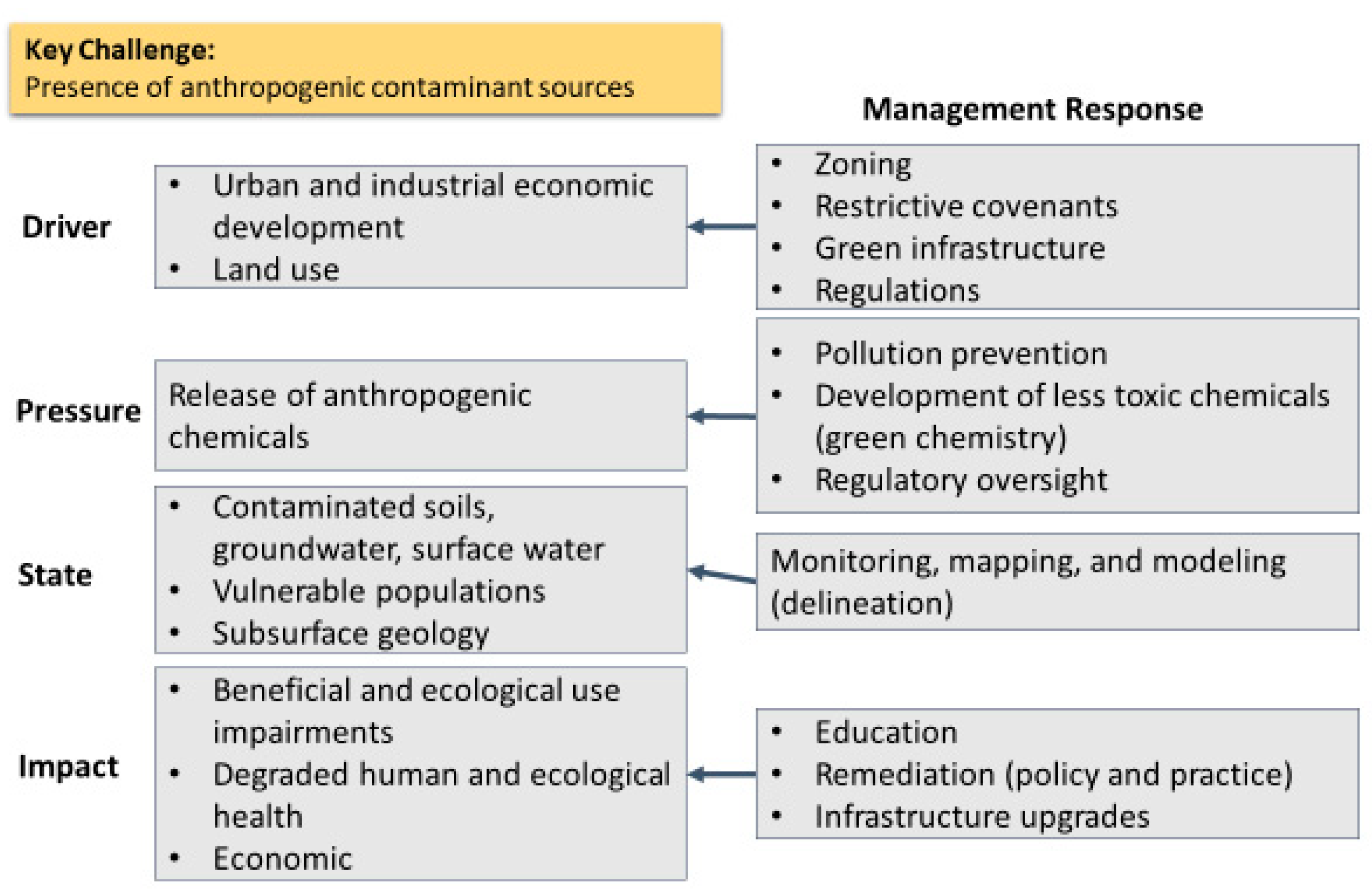
- Presence of anthropogenic contaminant sources
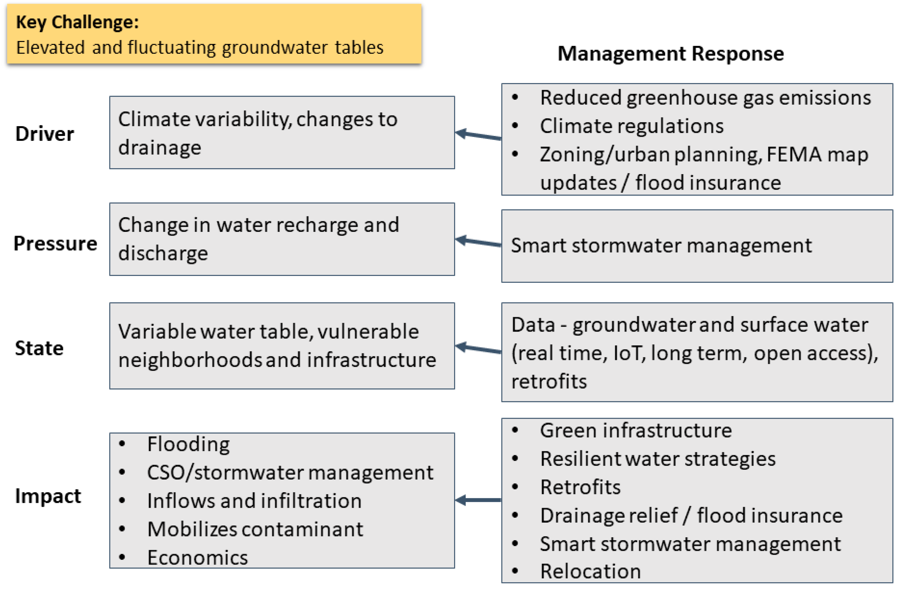
- Elevated and fluctuating groundwater tables
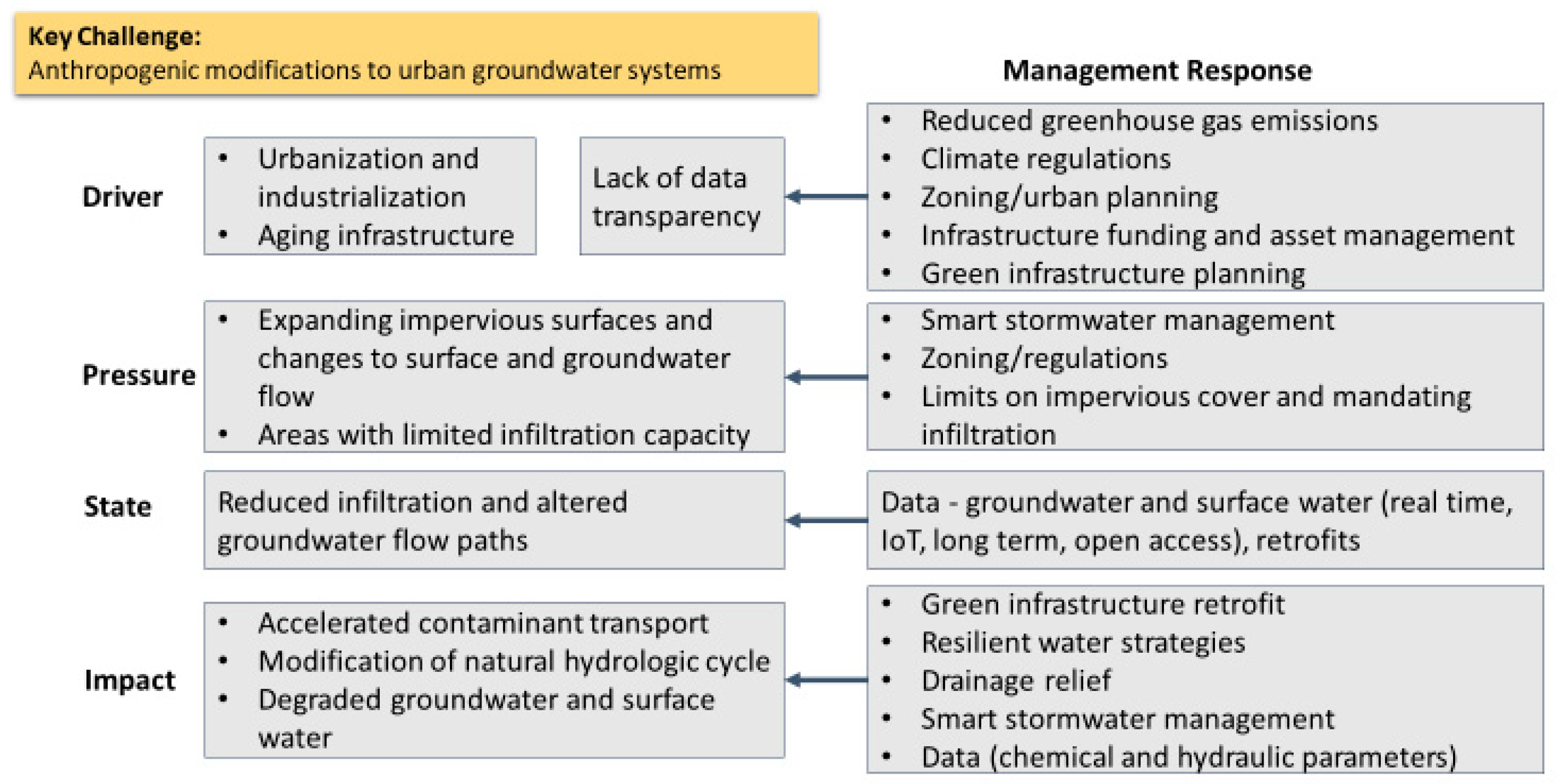
- Anthropogenic modifications to urban groundwater systems
3.3.2. DPSIR Models
Anthropogenic Contaminant Sources Model
Groundwater Table Model
Anthropogenic Modifications Model
3.3.3. Discussion
Policy and Practice
- Address urban land use concerns: zoning, restrictive covenants, regulations
- Increase the use of green infrastructure to manage urban water
- Prevent anthropogenic pollutant releases in urban areas: pollution prevention, development of less toxic chemicals (green chemistry), regulatory oversight
- Manage urban water in a changing climate: climate regulations, zoning, urban planning, FEMA map updates, flood insurance, infrastructure funding and asset management, green infrastructure planning
Science/Info Gaps/Infrastructure
- Need for better stormwater management in urban centers: green infrastructure, resilient water strategies, retrofits, drainage relief, smart stormwater management, relocation, flood insurance.
- Address urban land use concerns: zoning/regulations, limits on impervious cover and mandating infiltration where feasible, alternative de-icers to minimize salinization of groundwater and surface water.
- Data—groundwater and surface water (real-time, IOT, long-term, open-access), retrofits.
Education and Outreach
- Education ideas:
- ∘
- Pollution prevention, development of less toxic chemicals (green chemistry)
- ∘
- Stormwater management
- ∘
- Salinization reduction
- ∘
- Infrastructure upgrades
- ∘
- Climate impacts
- ∘
- Scientific process
- Outreach ideas:
- ∘
- Green infrastructure
- ∘
- Flood insurance
- ∘
- Citizen science
- ∘
- Environmental justice
- ∘
- Data translation
- ∘
- Conservation
- ∘
- Native plants/grasses
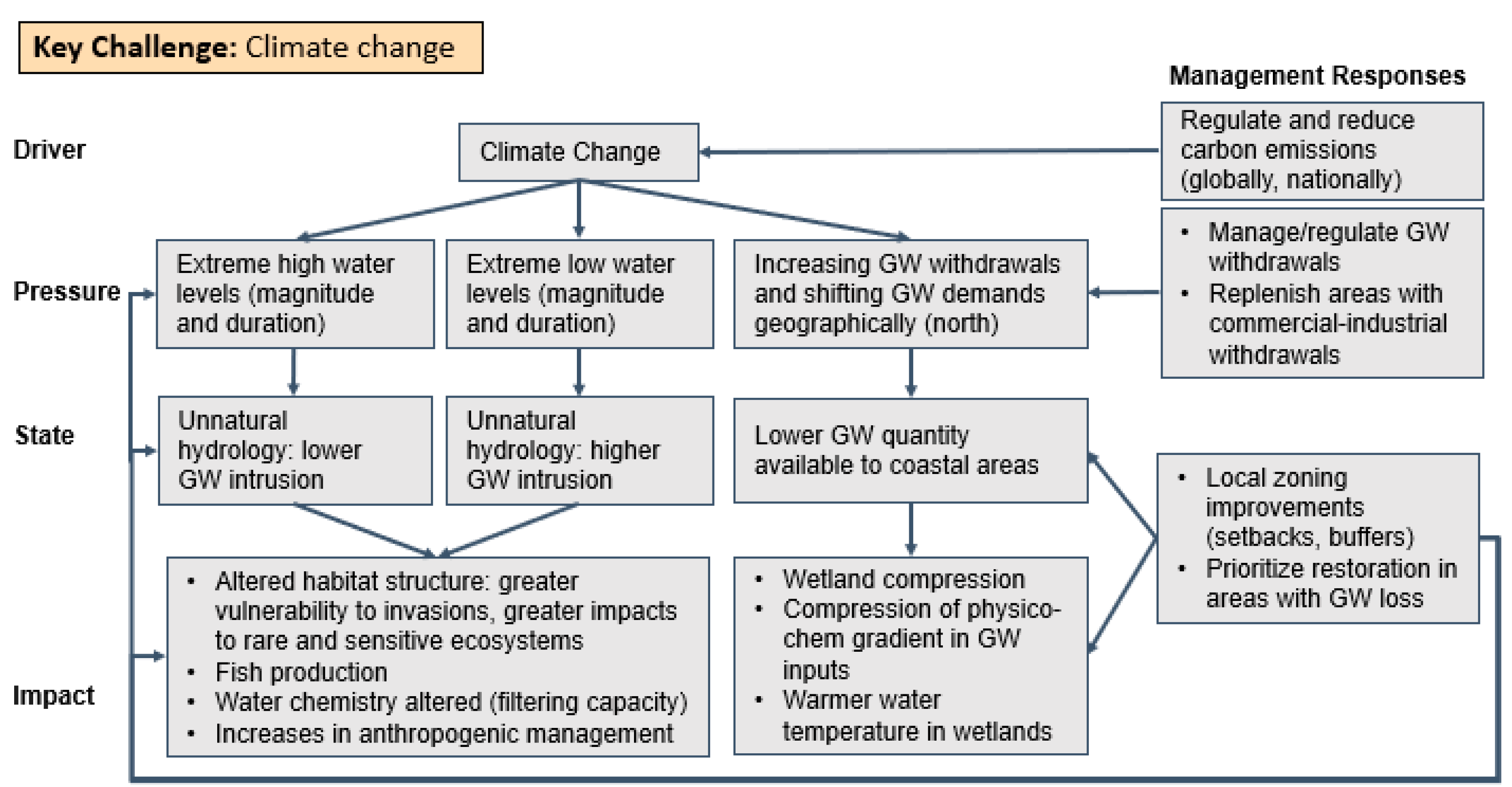
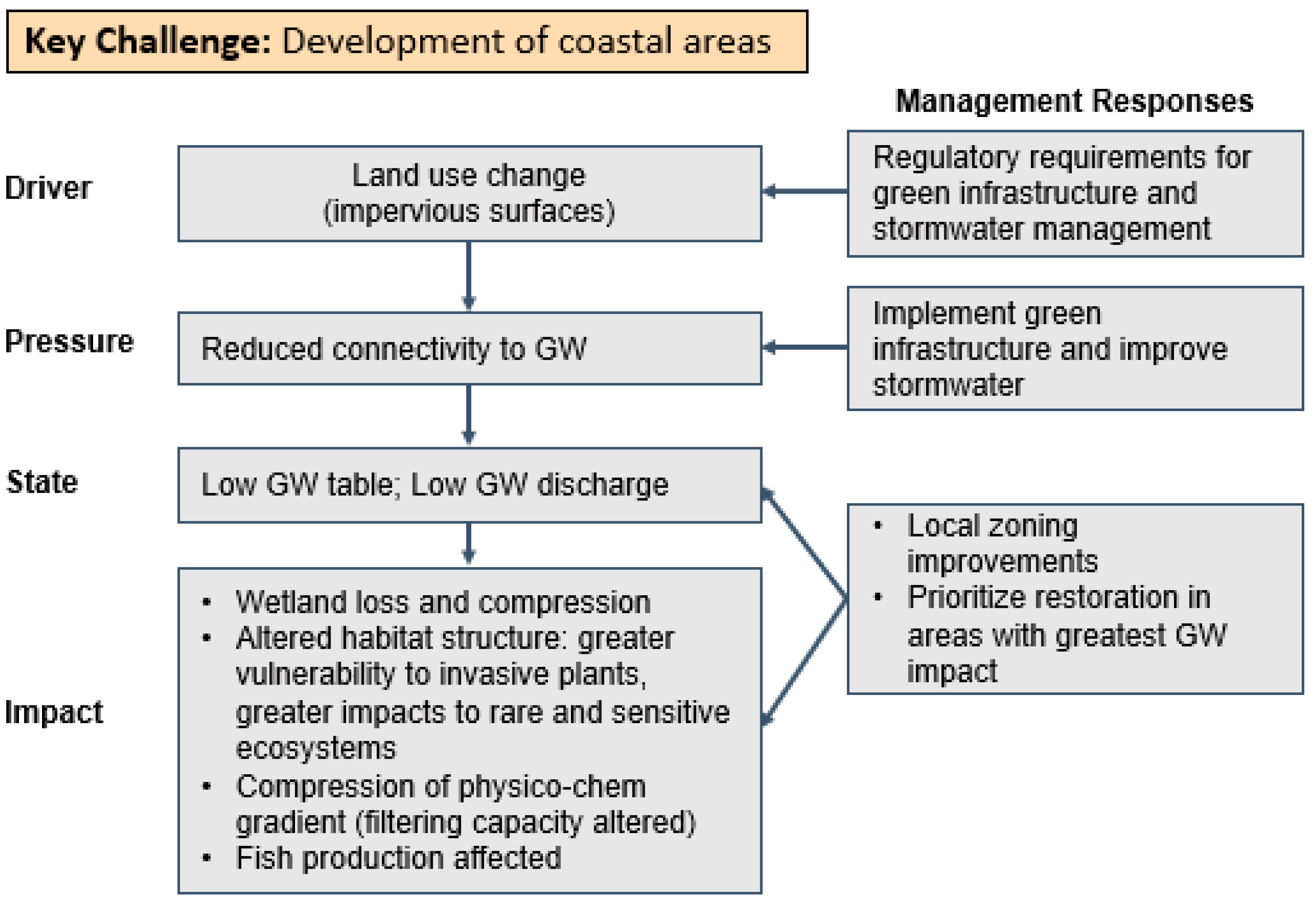
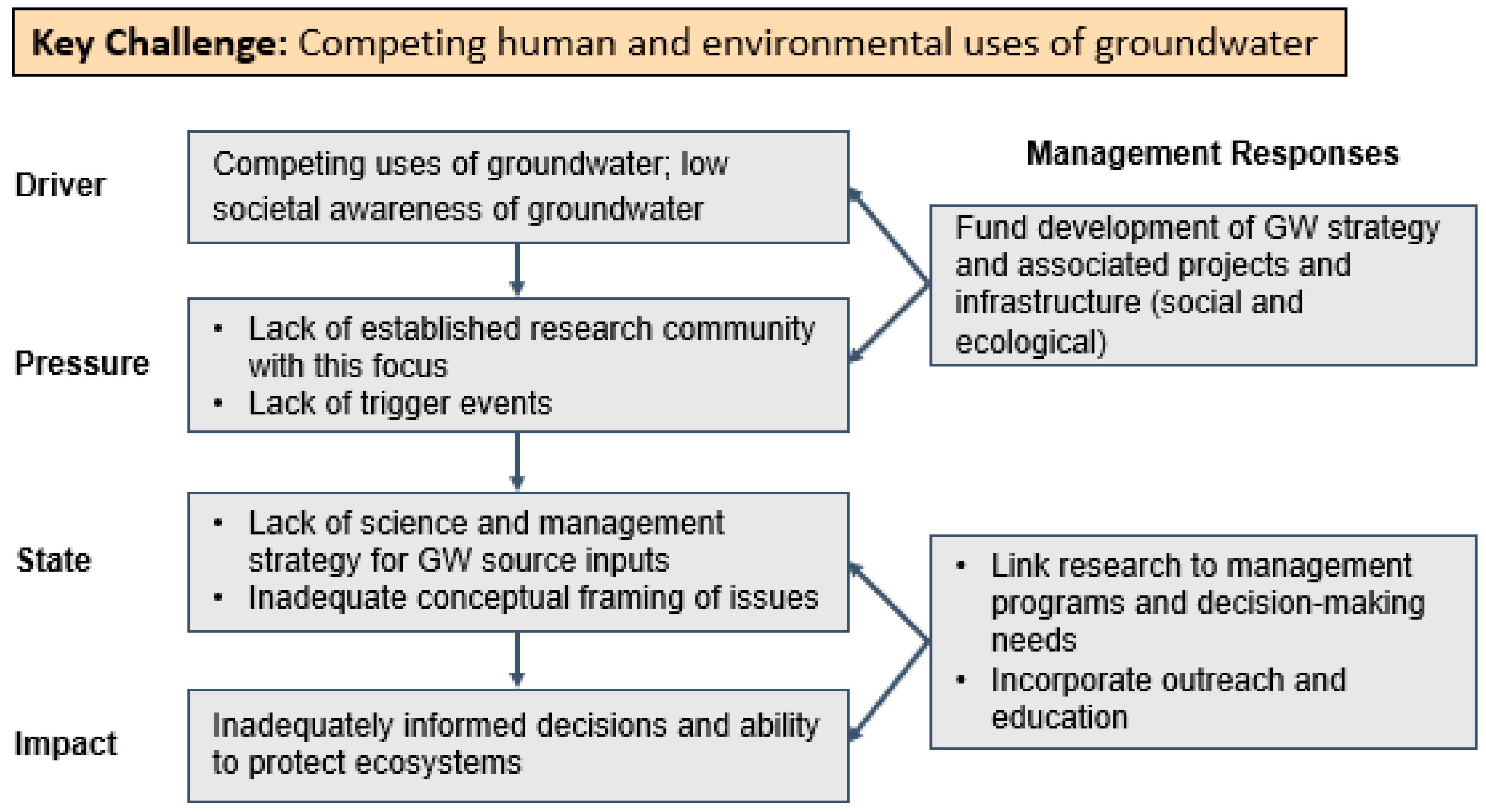
3.4. Groundwater in the Coastal Wetland Sector
3.4.1. Key Challenges
3.4.2. DPSIR Models
Climate Change Model
Development Model
Competing Human and Ecological Uses of Groundwater Model
3.4.3. Discussion
4. Summary and Recommendations
- Develop a statewide groundwater budget
- Coordinate data collection/management activities into a coordinated information management system
- Enhance and refine the Michigan Water Use Program and the Water Withdrawal Assessment Tool
- Develop a statewide groundwater monitoring program focused on contaminants
- Develop an early warning system to envision the future state of supply and demand
- Develop an interactive decision-making tool to quantify the impact of potential new withdrawals based on real-time groundwater monitoring data and enhanced geologic mapping data
- Improve our public education and outreach efforts to improve the public’s general lack of understanding of groundwater, and especially its connectivity to surface water
- Create new information and visualization tools to explain groundwater science and policy
- Instill the importance of water conservation
- Garner more input from underrepresented communities to obtain multiple perspectives
- Although we did not reach a consensus on how we should advocate on behalf of groundwater as a resource, there was general agreement regarding the need for more effective strategies to garner the resources and attention on groundwater as a growing Great Lakes issue
- The Michigan WUAC is statutorily charged to report and make recommendations biennially to the Legislature. It can be an effective advocate for groundwater in Michigan given its diverse membership, with appointees representing: business and manufacturing, public utilities, anglers, agricultural and non-agricultural irrigators, well drillers, local units of government, wetlands conservation, municipal water supplies, riparian landowners, professional hydrogeologists, Indian tribes, the aggregate industry, environmental organizations, and local watershed councils.
Supplementary Materials
Author Contributions
Funding
Acknowledgments
Conflicts of Interest
References
- Giordano, M. Global groundwater? Issues and solutions. Annu. Rev. Environ. Resour. 2009, 34, 153–178. [Google Scholar] [CrossRef]
- Siebert, S.; Burke, J.; Faures, J.M.; Frenken, K.; Hoogeveen, J.; Döll, P.; Portmann, F.T. Groundwater use for irrigation—A global inventory. Hydrol. Earth Syst. Sci. 2010, 14, 1863–1880. [Google Scholar] [CrossRef] [Green Version]
- Scanlon, B.R.; Faunt, C.C.; Longuevergne, L.; Reedy, R.C.; Alley, W.M.; McGuire, V.L.; McMahon, P.B. Groundwater depletion and sustainability of irrigation in the US High Plains and Central Valley. Proc. Natl. Acad. Sci. USA 2012, 109, 9320–9325. [Google Scholar] [CrossRef] [PubMed] [Green Version]
- Schewe, J.; Heinke, J.; Gerten, D.; Haddeland, I.; Arnell, N.W.; Clark, D.B.; Dankers, R.; Eisner, S.; Fekete, B.M.; Colón-González, F.J.; et al. Multimodel assessment of water scarcity under climate change. Proc. Natl. Acad. Sci. USA 2014, 111, 3245–3250. [Google Scholar] [CrossRef] [Green Version]
- Jasechko, S.; Perrone, D. Global groundwater wells at risk of running dry. Science 2021, 372, 418–421. [Google Scholar] [CrossRef]
- Levy, Z.F.; Jurgens, B.C.; Burow, K.R.; Voss, S.A.; Faulkner, K.E.; Arroyo-Lopez, J.A.; Fram, M.S. Critical aquifer overdraft accelerates degradation of groundwater quality in California’s Central Valley during drought. Geophys. Res. Lett. 2021, 48, e2021GL094398. [Google Scholar] [CrossRef]
- Safaie, A.; Litchman, E.; Phanikumar, M.S. Decreasing Groundwater Supply Can Exacerbate Lake Warming and Trigger Algal Blooms. J. Geophys. Res. Biogeosci. 2021, 126, e2021JG006455. [Google Scholar] [CrossRef]
- Zhang, Z.; Wang, W. Managing aquifer recharge with multi-source water to realize sustainable management of groundwater resources in Jinan, China. Environ. Sci. Poll. Res. 2021, 28, 10872–10888. [Google Scholar] [CrossRef]
- Saito, L.; Christian, B.; Diffley, J.; Richter, H.; Rohde, M.M.; Morrison, S.A. Managing groundwater to ensure ecosystem function. Groundwater 2021, 59, 322–333. [Google Scholar] [CrossRef]
- Varela-Ortega, C.; Blanco-Gutiérrez, I.; Swartz, C.H.; Downing, T.E. Balancing groundwater conservation and rural livelihoods under water and climate uncertainties: An integrated hydro-economic modeling framework. Glob. Environ. Chang. 2011, 21, 604–619. [Google Scholar] [CrossRef] [Green Version]
- Lall, U.; Josset, L.; Russo, T.A. snapshot of the world’s groundwater challenges. Annu. Rev. Environ. Resour. 2020, 45, 171–194. [Google Scholar] [CrossRef]
- Carl, L.M.; Hortness, J.E.; Strach, R.M. U.S. Geological Survey Great Lakes Science Forum—Summary of Remaining Data and Science Needs and Next Steps: U.S. Geological Survey Open-File Report 2021-1096. 2021. Available online: https://pubs.er.usgs.gov/publication/ofr20211096 (accessed on 1 February 2022).
- Solley, W.B.; Pierce, R.R.; Perlman, H.A. Estimate of Water Use in the United States; U.S. Geological Survey, Circular, 1200; U.S. Dept. of the Interior: Denver, CO, USA, 1998; p. 71.
- EGLE-Water Use Program. Annual Water Use Volumes by County and by Sector. 2019. Available online: https://www.michigan.gov/documents/egle/egle-wrd-wateruse-2019_county_water_use_data_712929_7.xlsx (accessed on 1 February 2022).
- Holtschlag, D.J.; Nicholas, J.R. Indirect Ground-Water Discharge to the Great Lakes USGS Open-File Report 98-579; U.S. Geological Survey: Lansing, MI, USA, 1998; p. 25.
- Grannemann, N.G.; Hunt, R.J.; Nicholas, J.R.; Reilly, T.E.; Winter, T.C. The Importance of Ground Water in the Great Lakes Region (No. 2000-4008); U.S. Geological Survey: Lansing, MI, USA, 2000.
- Wehrly, K.E.; Wiley, M.J.; Seelbach, P.W. Influence of Landscape Features on Summer Water Temperatures in Lower Michigan Streams. In American Fisheries Society Symposium; American Fisheries Society: New York, NY, USA, 2006; Volume 48, pp. 113–127. [Google Scholar]
- Sampath, P.V.; Liao, H.S.; Curtis, Z.K.; Doran, P.J.; Herbert, M.E.; May, C.A.; Li, S.G. Understanding the Groundwater Hydrology of a Geographically-Isolated Prairie Fen: Implications for Conservation. PLoS ONE 2015, 10, e0140430. [Google Scholar] [CrossRef] [Green Version]
- Sampath, P.V.; Liao, H.S.; Curtis, Z.K.; Herbert, M.E.; Doran, P.J.; May, C.A.; Landis, D.A.; Li, S.G. Understanding fen hydrology across multiple scales. Hydrol. Proc. 2016, 30, 3390–3407. [Google Scholar] [CrossRef]
- Crowe, A.S.; Shikaze, S.G. Linkages between groundwater and coastal wetlands of the Laurentian Great Lakes. Aquat. Ecosyst. Health Manag. 2004, 7, 199–213. [Google Scholar] [CrossRef]
- Xu, S.; Frey, S.K.; Erler, A.R.; Khader, O.; Berg, S.J.; Hwang, H.T.; Callaghan, M.V.; Davison, J.H.; Sudicky, E.A. Investigating groundwater-lake interactions in the Laurentian Great Lakes with a fully-integrated surface water-groundwater model. J. Hydrol. 2021, 594, 125911. [Google Scholar] [CrossRef]
- Herbert, M.E.; McIntyre, P.B.; Doran, P.J.; Allan, J.D.; Abell, R. Terrestrial reserve networks do not adequately represent aquatic ecosystems. Conserv. Biol. 2010, 24, 1002–1011. [Google Scholar] [CrossRef]
- Forest, A. The Approval of Waukesha’s Diversion Application under the Great Lakes—St. Lawrence Basin Water Resources Compact—Bad Precedent for the Great Lakes. Can.-US L.J. 2017, 41, 70–95. [Google Scholar]
- Annin, P. The Great Lakes Water Wars; Island Press: Washington, DC, USA, 2018. [Google Scholar]
- Moshman, R. Limitations on the Right to Use Water: A Case of First Impression in Michigan. Sustain. Dev. Law Policy 2011, 5, 11. [Google Scholar]
- Reeves, H.W.; Hamilton, D.A.; Seelbach, P.W.; Asher, A. Ground-Water-Withdrawal Component of the Michigan Water-Withdrawal Screening Tool; U.S. Geological Survey: Reston, VS, USA, 2009.
- Steinman, A.D.; Luttenton, M.; Havens, K.E. Sustainability of surface and subsurface water resources: Case studies from Florida and Michigan, USA. Water Resour. 2004, 127, 100–107. [Google Scholar]
- Steinman, A.D.; Nicholas, J.R.; Seelbach, P.W.; Allan, J.W.; Ruswick, F. Science as a fundamental framework for shaping policy discussions regarding the use of groundwater in the State of Michigan: A case study. Water Policy 2011, 13, 69–86. [Google Scholar] [CrossRef]
- Talpos, S. They persisted. Science 2019, 364, 622–626. [Google Scholar] [CrossRef] [PubMed]
- Water Use Advisory Council. Michigan Water Use Advisory Council 2020 Report. 2020. Available online: https://www.michigan.gov/documents/egle/egle-wrd-wateruse-WUAC_2020_council_report_711968_7.pdf (accessed on 1 February 2022).
- Hamilton, D. Michigan Hydrologic Framework. Report. 2018. Available online: https://www.michigan.gov/documents/egle/egle-wrd-wateruse-WUAC_Michigan_Hydrologic_Framework_702219_7.pdf (accessed on 4 February 2022).
- Murray, M.W.; Steinman, A.D.; Allan, J.D.; Bratton, J.F.; Johnson, L.B.; Ciborowski, J.J.H.; Stow, C.A. Conceptual Frameworks and Great Lakes Restoration and Protection: A White Paper; National Wildlife Federation, Great Lakes Regional Center: Ann Arbor, MI, USA, 2019. [Google Scholar]
- Atkins, J.P.; Burdon, D.; Elliott, M.; Gregory, A.J. Management of the marine environment: Integrating ecosystem services and societal benefits with the DPSIR framework in a systems approach. Mar. Pollut. Bull. 2011, 62, 215–226. [Google Scholar] [CrossRef] [PubMed]
- FLOW (For Love of Water). Deep Threats to Our Sixth Great Lake. Traverse City, MI, USA, 2021. Available online: https://forloveofwater.org/wp-content/uploads/2021/03/FLOW-Deep-Threats-Groundwater-REPORT-FINAL-3-9-2021.pdf (accessed on 1 February 2022).
- Costa, D.; Zhang, H.; Levison, J. Impacts of climate change on groundwater in the Great Lakes Basin: A review. J. Great Lakes Res. 2021, 47, 1613–1625. [Google Scholar] [CrossRef]
- IJC (International Joint Commission). Development of a Great Lakes Groundwater and Surface Water Conceptual Framework. Final Report; LimnoTech: Ann Arbor, MI, USA, 2021. [Google Scholar]
- Cohen, A. The Sixth Great Lake: Groundwater in the Great Lakes-St. Lawrence Basin. Program on Water Governance. 2009. Available online: https://watergovernance.sites.olt.ubc.ca/files/2009/09/Groundwater_in_the_Great_Lakes.pdf (accessed on 29 December 2021).
- USDA National Agricultural Statistics Service. Irrigation and Water Management Survey. 2018. Available online: https://www.nass.usda.gov/Publications/AgCensus/2017/Online_Resources/Farm_and_Ranch_Irrigation_Survey/index.php (accessed on 4 February 2022).
- Michigan Farm Bureau. Michigan Agriculture Facts. 2021. Available online: https://new.michfb.com/agriculture/michigan-agriculture-facts (accessed on 9 October 2021).
- USDA National Agricultural Statistics Service. Census of Agriculture. 1997. Available online: https://agcensus.library.cornell.edu/census_year/1997-census/ (accessed on 4 February 2022).
- USDA National Agricultural Statistics Service. Census of Agriculture. 2017. Available online: https://www.nass.usda.gov/Publications/AgCensus/2017/ (accessed on 4 February 2022).
- USDA National Agricultural Statistics Service. Farm and Ranch Irrigation Survey. 2008. Available online: https://agcensus.library.cornell.edu/census_parts/2007-farm-and-ranch-irrigation-survey/ (accessed on 4 February 2022).
- EGLE (Michigan Department of Environment, Great Lakes, and Energy). Water Withdrawal Assessment Tool Registration Requests. 2021. Available online: https://www.michigan.gov/documents/egle/egle-wrd-wateruse-WWAT_registration_list_711274_7.xls (accessed on 1 February 2022).
- EGLE. Annual Water Use Volumes by County and by Sector. 2010. Available online: https://www.michigan.gov/documents/egle/egle-wrd-wateruse-2010_water_use_data_690400_7.xlsx (accessed on 1 February 2022).
- Schneider, K. As Drought Grips American West, Irrigation Becomes Selling Point for Michigan. Circle of Blue. 2021. Available online: https://www.circleofblue.org/2021/world/as-drought-grips-american-west-irrigation-becomes-selling-point-for-michigan/ (accessed on 1 February 2022).
- MDARD (Michigan Department of Agriculture and Rural Development). Generally Accepted Agricultural and Management Practices for Nutrient Utilization. 2022. Available online: https://www.michigan.gov/mdard/-/media/Project/Websites/mdard/documents/environment/rtf/2022-GAAMPs/2022-Nutrient-Utilization-GAAMPs.pdf?rev=a08ce9e09a1549caaa107b1c128ca5dd&hash=16376B27E8BEE00C772346C5A6F6AF6B (accessed on 4 February 2022).
- USEPA. Commercial Fertilizer Purchased. 2020. Available online: https://www.epa.gov/nutrient-policy-data/commercial-fertilizer-purchased (accessed on 1 February 2022).
- MDARD. Generally Accepted Agricultural and Management Practices for Pesticide Utilization and Pest Control. 2021; 26p. Available online: https://www.michigan.gov/documents/mdard/Pesticide_Utilization_and_Pest_Control_GAAMPs_2021_714233_7.pdf (accessed on 1 February 2022).
- Minnesota Groundwater Association. Drain Tiles and Groundwater Resources: Understanding the Relations. 2018. Available online: www.mgwa.org/documents/white-papers/Drain_Tiles_and_Groundwater_Resources.pdf (accessed on 28 January 2022).
- Clement, D.R.; Steinman, A.D. Phosphorus loading and ecological impacts from agricultural tile drains in a west Michigan watershed. J. Great Lakes Res. 2017, 43, 50–58. [Google Scholar] [CrossRef]
- Mrdjen, I.; Fennessy, S.; Schaal, A.; Dennis, R.; Slonczewski, J.L.; Lee, S.; Lee, J. Tile drainage and anthropogenic land use contribute to harmful algal blooms and microbiota shifts in inland water bodies. Environ. Sci. Technol. 2018, 52, 8215–8223. [Google Scholar] [CrossRef]
- MSUE (Michigan State University Extension). Value of Irrigation to the Southwest Michigan Economy. 2014. 16p. Available online: https://www.canr.msu.edu/uploads/235/67987/resources/SWMichiganValueOfIrrigation9-23-14.pdf (accessed on 4 February 2022).
- Wuebbles, D.; Cardinale, B.; Cherkauer, K.; Davidson-Arnott, R.; Hellmann, J.; Infante, D.; Johnson, L.; de Loë, R.; Lofgren, B.; Packman, A.; et al. An Assessment of the Impacts of Climate Change on the Great Lakes. Environmental Law & Policy Center. 2019. 74p. Available online: https://elpc.org/resources/the-impacts-of-climate-change-on-the-great-lakes/ (accessed on 4 February 2022).
- USGCRP (U.S. Global Change Research Program). Climate Science Special Report: Fourth National Climate Assessment; USGCRP: Washington, DC, USA, 2017; Volume I. [CrossRef] [Green Version]
- Byun, K.; Hamlet, A. Projected changes in future climate over the Midwest and Great Lakes region using downscaled CMIP5 ensembles. Int. J. Climatol. 2018, 38, e531–e553. [Google Scholar] [CrossRef]
- Hem, J. Study and Interpretation of the chemical characteristics of natural water. In U.S. Geological Survey Water-Supply Paper 2254, 3rd ed.; USGS: Reston, VA, USA, 1985; p. 264. [Google Scholar]
- Curtis, Z.; Liao, H.; Li, S.; Sampath, P.; Lusch, D.A. Multiscale assessment of shallow groundwater salinization in Michigan. Groundwater 2019, 57, 784–806. [Google Scholar] [CrossRef]
- MDARD. Generally Accepted Agricultural and Management Practices for Irrigation Water Use. 2021; 24p. Available online: https://www.michigan.gov/documents/mdard/Irrigation_Water_Use_2021_GAAMPS_714232_7.pdf (accessed on 4 February 2022).
- Warncke, D.; Dahl, J.; Jacobs, L.; Laboski, C. Nutrient Recommendations for Field Crops in Michigan. MSU Extension Bulletin No. E-2904. 2009. Available online: https://soils.msu.edu/wp-content/uploads/2014/06/MSU-Nutrient-recomdns-field-crops-E-2904.pdf (accessed on 4 February 2022).
- Warncke, D.D.; Dahl, J.; Zandstra, B. Nutrient Recommendations for Vegetable Crops in Michigan. MSU Extension Bulletin No. E-2934. 2004. Available online: https://soils.msu.edu/wp-content/uploads/2014/06/MSU-Nutrient-recomdns-veg-crops-E-2934.pdf (accessed on 4 February 2022).
- Sprague, C. 2020 Weed Control Guide for Field Crops. 2020. Available online: https://www.canr.msu.edu/weeds/extension/2020-weed-control-guide (accessed on 4 February 2022).
- Mikkelsen, R. Understanding Fertilizer and Its Essential Role in High-Yielding Crops. 2021. Available online: https://www.cropnutrition.com/resource-library/understanding-fertilizer-and-its-essential-role-in-high-yielding-crops (accessed on 4 February 2022).
- WSSA (Weed Science Society of America). Crop Loss. 2021. Available online: https://wssa.net/wssa/weed/croploss-2/ (accessed on 4 February 2022).
- Basso, B.; Ritchie, J.T. Impact of compost, manure and inorganic fertilizer on nitrate leaching and yield for a 6-year maize–alfalfa rotation in Michigan. Agric. Ecosyst. Environ. 2005, 108, 329–341. [Google Scholar] [CrossRef]
- Power, J.F.Y.; Schepers, J.S. Nitrate contamination of groundwater in North America. Agric. Ecosyst. Environ. 1989, 26, 165–187. [Google Scholar] [CrossRef]
- Hill, A.R. Nitrate distribution in the ground water of the Alliston region of Ontario, Canada. Groundwater 1982, 20, 696–702. [Google Scholar] [CrossRef]
- FLOW. The Sixth Great Lake. 2018. Available online: https://forloveofwater.org/sixth-great-lake/ (accessed on 8 June 2021).
- MDARD. MAEAP Water Monitoring Annual Report. 2020. Available online: https://www.michigan.gov/documents/mdard/2020_MAEAP_Water_Monitoring_Annual_Report_717929_7.pdf (accessed on 4 February 2022).
- Agency for Toxic Substances and Disease Registry, U.S. Department of Health and Human Services. WB2342: Case Study in Environmental Medicine (CSEM) Nitrate/Nitrite Toxicity. 2013. Available online: https://www.atsdr.cdc.gov/csem/nitrate_2013/docs/nitrite.pdf (accessed on 29 December 2021).
- Gilden, R.; Huffling, K.; Sattler, B. Pesticides and health risks. J. Obstet. Gynecol. Neonatal Nurs. 2010, 39, 103–110. [Google Scholar] [CrossRef] [PubMed]
- Michigan Office of the Great Lakes. Sustaining Michigan’s Water Heritage: A Strategy for the Next Generation. 2016; 76p. Available online: https://www.michigan.gov/documents/deq/deq-ogl-waterstrategy_538161_7.pdf (accessed on 1 February 2022).
- Fales, M.; Sowa, S.P.; Dell, R.; Herbert, M.; Asher, J.; O’Neil, G.; Doran, P.J.; Wickerham, B. Making the leap from science to implementation: Strategic agricultural conservation in the Saginaw Bay watershed. J. Great Lakes Res. 2016, 42, 1372–1385. [Google Scholar] [CrossRef] [Green Version]
- GLISA (Great Lakes Integrated Sciences and Assessments). Regional Integrated Sciences and Assessments. Precipitation. 2021. Available online: https://glisa.umich.edu/resources-tools/climate-impacts/precipitation/ (accessed on 4 February 2022).
- Hall, K.R.; Herbert, M.E.; Sowa, S.P.; Mysorekar, S.; Woznicki, S.A.; Nejadhashemi, P.A.; Wang, L. Reducing current and future risks: Using climate change scenarios to test an agricultural conservation framework. J. Great Lakes Res. 2017, 43, 59–68. [Google Scholar] [CrossRef] [Green Version]
- Zulauf, C.; Brown, B. Use of Drainage Tile up 14%, According to the 2017 U.S. Census of Agriculture. Michigan Farm News. 7 August 2019. Available online: https://www.michiganfarmnews.com/use-of-drainage-tile-up-14-according-to-the-2017-us-census-of-agriculture (accessed on 4 February 2022).
- Plach, J.M.; Macrae, M.L.; Ali, G.A.; Brunke, R.R.; English, M.C.; Ferguson, G.; Lam, W.V.; Lozier, T.M.; McKague, K.; O’Halloran, I.P.; et al. Supply and transport limitations on phosphorus losses from agricultural fields in the lower Great Lakes region, Canada. J. Environ. Qual. 2018, 47, 96–105. [Google Scholar] [CrossRef] [PubMed] [Green Version]
- Curtis, Z.; Liao, H.; Li, S. Ottawa County Water Resources Study—Phase 2 Final Report; Institute for Water Research: East Lansing, MI, USA, 2018; p. 166. [Google Scholar]
- Sharp, J.M. The impacts of urbanization on groundwater systems and recharge. Aqua PMundi 2010, 1, 51–56. [Google Scholar] [CrossRef]
- Vázquez-Suñé, E.; Sánchez-Vila, X.; Carrera, J. Introductory review of specific factors influencing urban groundwater, an emerging branch of hydrogeology, with reference to Barcelona, Spain. Hydrogeol. J. 2005, 13, 522–533. [Google Scholar] [CrossRef]
- Wong, C.I.; Sharp, J.M., Jr.; Hauwert, N.; Landrum, J.; White, K.M. Impact of urban development on physical and chemical hydrogeology. Elements 2012, 8, 429–434. [Google Scholar] [CrossRef]
- Howard, K.; Gerber, R. Impacts of urban areas and urban growth on groundwater in the Great Lakes Basin of North America. J. Great Lakes Res. 2018, 44, 1–13. [Google Scholar] [CrossRef]
- Kaufman, M.M.; Rogers, D.T.; Murray, K.S. Using soil and contaminant properties to assess the potential for groundwater contamination to the lower Great Lakes, USA. Environ. Geol. 2009, 56, 1009–1021. [Google Scholar] [CrossRef]
- Peche, A.; Graf, T.; Fuchs, L.; Neuweiler, I. Physically based modeling of stormwater pipe leakage in an urban catchment. J. Hydrol. 2019, 573, 778–793. [Google Scholar] [CrossRef]
- ASCE (American Society of Civil Engineers). 2017. Available online: https://csengineermag.com/asce-releases-2017-infrastructure-report-card/ (accessed on 10 September 2021).
- McGrane, S.J. Impacts of urbanisation on hydrological and water quality dynamics, and urban water management: A review. Hydrol. Sci. J. 2016, 61, 2295–2311. [Google Scholar] [CrossRef]
- Perles Roselló, M.J.; Vías Martinez, J.M.; Andreo Navarro, B. Vulnerability of human environment to risk: Case of groundwater contamination risk. Environ. Int. 2009, 35, 325–335. [Google Scholar] [CrossRef] [PubMed]
- Claessens, L.; Hopkinson, C.; Rastetter, E.; Vallino, J. Effect of historical changes in land use and climate on the water budget of an urbanizing watershed. Water Resour. Res. 2006, 42. [Google Scholar] [CrossRef] [Green Version]
- Joyce, J.; Chang, N.B.; Harji, R.; Ruppert, T.; Imen, S. Developing a multi-scale modeling system for resilience assessment of green-grey drainage infrastructures under climate change and sea level rise impact. Environ. Model. Softw. 2017, 90, 1–26. [Google Scholar] [CrossRef]
- Qi, S.; Luo, J.; O’Connor, D.; Cao, X.; Hou, D. Influence of groundwater table fluctuation on the non-equilibrium transport of volatile organic contaminants in the vadose zone. J. Hydrol. 2020, 580, 124353. [Google Scholar] [CrossRef]
- Bhaskar, A.S.; Beesley, L.; Burns, M.J.; Fletcher, T.D.; Hamel, P.; Oldham, C.E.; Roy, A.H. Will it rise or will it fall? Managing the complex effects of urbanization on base flow. Freshw. Sci. 2016, 35, 293–310. [Google Scholar] [CrossRef] [Green Version]
- Teimoori, S.; O’Leary, B.F.; Miller, C.J. Modeling Shallow Urban Groundwater at Regional and Local Scales: A Case Study in Detroit, MI. Water 2021, 13, 1515. [Google Scholar] [CrossRef]
- Filippelli, G.M.; Risch, M.; Laidlaw, M.A.S.; Nichols, D.E.; Crewe, J. Geochemical legacies and the future health of cities: A tale of two neurotoxins in urban soils. Elem. Sci. Anthr. 2015, 3, 000059. [Google Scholar] [CrossRef] [Green Version]
- Collins, M.B.; Munoz, I.; JaJa, J. Linking ‘toxic outliers’ to environmental justice communities. Environ. Res. Lett. 2016, 11, 015004. [Google Scholar] [CrossRef]
- Eckerd, A.; Keeler, A.G. Going green together? Brownfield remediation and environmental justice. Policy Sci. 2012, 45, 293–314. [Google Scholar] [CrossRef]
- Lee, S.; Mohai, P. Racial and socioeconomic assessments of neighborhoods adjacent to small-scale brownfield sites in the Detroit region. Environ. Pract. 2011, 13, 340–353. [Google Scholar] [CrossRef]
- Sampson, N.; Price, C.; Kassem, J.; Doan, J.; Hussein, J. “We’re Just Sitting Ducks”: Recurrent Household Flooding as An Underreported Environmental Health Threat in Detroit’s Changing Climate. Internat. J. Environ. Res. Public Health 2019, 16, 6. [Google Scholar] [CrossRef] [PubMed] [Green Version]
- Squillace, P.J.; Moran, M.J.; Price, C.V. VOCs in Shallow Groundwater in New Residential/Commercial Areas of the United States. Environ. Sci. Technol. 2004, 38, 5327–5338. [Google Scholar] [CrossRef]
- Voisin, J.; Cournoyer, B.; Vienney, A.; Mermillod-Blondin, F. Aquifer recharge with stormwater runoff in urban areas: Influence of vadose zone thickness on nutrient and bacterial transfers from the surface of infiltration basins to groundwater. Sci. Total Environ. 2018, 637–638, 1496–1507. [Google Scholar] [CrossRef] [PubMed]
- Yu, L.; Rozemeijer, J.C.; van der Velde, Y.; van Breukelen, B.M.; Ouboter, M.; Broers, H.P. Urban hydrogeology: Transport routes and mixing of water and solutes in a groundwater influenced urban lowland catchment. Sci. Total Environ. 2019, 678, 288–300. [Google Scholar] [CrossRef] [PubMed]
- GLCWC (Great Lakes Coastal Wetland Consortium). Great Lakes Coastal Wetland Inventory; A Geospatial Dataset; On Behalf of the Great Lakes Commission: Ann Arbor, MI, USA, 2004. [Google Scholar]
- Knights, D.; Parks, K.C.; Sawyer, A.H.; David, C.H.; Browning, T.N.; Danner, K.M.; Wallace, C.D. Direct groundwater discharge and vulnerability to hidden nutrient loads along the Great Lakes coast of the United States. J. Hydrol. 2017, 554, 331–341. [Google Scholar] [CrossRef]
- Trebitz, A.S. Characterizing seiche and tide-driven daily water level fluctuations affecting coastal ecosystems of the Great Lakes. J. Great Lakes Res. 2006, 32, 102–116. [Google Scholar] [CrossRef]
- Gronewold, A.D.; Rood, R.B. Recent water level changes across Earth’s largest lake system and implications for future variability. J. Great Lakes Res. 2019, 45, 1–3. [Google Scholar] [CrossRef]
- Gronewold, A.D.; Stow, C.A. Water loss from the great lakes. Science 2014, 343, 1084–1085. [Google Scholar] [CrossRef]
- Crowe, A.S.; Meek, G.A. Groundwater conditions beneath beaches of Lake Huron, Ontario, Canada. Aquat. Ecosyst. Health Manag. 2009, 12, 444–455. [Google Scholar] [CrossRef]
- Haack, S.K.; Neff, B.P.; Rosenberry, D.O.; Savino, J.F.; Lundstrom, S.C. An evaluation of effects of groundwater exchange on nearshore habitats and water quality of Western Lake Erie. J. Great Lakes Res. 2005, 31, 45–63. [Google Scholar] [CrossRef]
- King, M.; Altdorff, D.; Li, P.; Galagedara, L.; Holden, J.; Unc, A. Northward shift of the agricultural climate zone under 21st-century global climate change. Sci. Rep. 2018, 8, 7904. [Google Scholar] [CrossRef] [PubMed] [Green Version]
- Austin, J.; Steinman, A.D. Michigan Blue Economy. Making Michigan the World’s Freshwater and Freshwater Innovation Capital. 2015. Available online: https://michiganblueeconomy.org/ (accessed on 10 September 2021).
- EGLE. Great Lakes Coastal Wetlands. 2021. Available online: https://www.michigan.gov/egle/0,9429,7-135-3313_3687-11177--,00.html (accessed on 28 June 2021).
- Chen, J.Q.; Theller, L.; Gitau, M.W.; Engel, B.A.; Harbor, J.M. Urbanization impacts on surface runoff of the contiguous United States. J. Environ. Manag. 2017, 187, 470–481. [Google Scholar] [CrossRef]
- Erickson, T.O.; Stefan, H.G. Natural groundwater recharge response to urbanization: Vermillion River Watershed, Montana. J. Water Resour. Plan. Manag. 2009, 135, 512–520. [Google Scholar] [CrossRef]
- Morrice, J.A.; Trebitz, A.S.; Kelly, J.R.; Sierszen, M.E.; Cotter, A.M.; Hollenborst, T. Determining sources of water to Great Lakes coastal wetlands: A classification approach. Wetlands 2011, 31, 119–1213. [Google Scholar] [CrossRef]
- Barron, O.V.; Barr, A.D.; Donn, M.J. Effect of urbanization on the water balance of a catchment with shallow groundwater. J. Hydrol. 2013, 485, 162–176. [Google Scholar] [CrossRef]
- Ehrenfeld, J.G. Evaluating wetlands within an urban context. Urban Ecosyst. 2000, 4, 69–85. [Google Scholar] [CrossRef]
- Baer, S.; Robertson, W.; Spoelstra, J.; Schiff, S. Phosphorus and nitrogen loading to Lake Huron from septic systems at Grand Bend, ON. J. Great Lakes Res. 2019, 45, 642–650. [Google Scholar] [CrossRef]
- Brennan, A.K.; Hoard, C.J.; Duris, J.W.; Ogdahl, M.E.; Steinman, A.D. Water quality and hydrology of Silver Lake, Oceana County, Michigan, with emphasis on lake response to nutrient loading, 2012–2014. In U.S. Geological Survey Scientific Investigations Report 2015–5158; U.S. Geological Survey: Reston, VA, USA, 2016. [Google Scholar] [CrossRef] [Green Version]
- Robinson, C. Review on groundwater as a source of nutrients to the Great Lakes and their tributaries. J. Great Lakes Res. 2015, 41, 941–950. [Google Scholar] [CrossRef]
- Smith, I.M.; Fiorino, G.E.; Grabas, G.P.; Wilcox, D.A. Wetland vegetation response to record-high Lake Ontario water levels. J. Great Lakes Res. 2021, 47, 160–167. [Google Scholar] [CrossRef]
- Newman, S.; Grace, J.B.; Koebel, J.W. Effects of nutrients and hydroperiod on Typha, Cladium, and Eleocharis: Implications for Everglades restoration. Ecol. Appl. 1996, 6, 774–783. [Google Scholar] [CrossRef]
- Uzarski, D.G.; Burton, T.M.; Kolar, R.E.; Cooper, M.J. The ecological impacts of fragmentation and vegetation removal in Lake Huron coastal wetlands. Aquat. Ecosyst. Health Manag. 2009, 12, 45–62. [Google Scholar] [CrossRef]
- Wilcox, D.A.; Shedlock, R.J.; Hendrickson, W.H. Hydrology, water chemistry and ecological relations in the raised mound of Cowles Bog. J. Ecol. 1986, 74, 1127–1137. [Google Scholar] [CrossRef]
- GWCAC (Groundwater Conservation Advisory Council). Final Report to the Michigan Legislature in Response to Public Act 148 of 2003; Michigan Department of Environmental Quality: Lansing, MI, USA, 2006.
- Nilsson, M.; Griggs, D.; Visbeck, M. Policy: Map the interactions between Sustainable Development Goals. Nature 2016, 534, 320–322. [Google Scholar] [CrossRef]
- Xu, B.; Liu, S.; Zhou, J.L.; Zheng, C.; Weifeng, J.; Chen, B.; Zhang, T.; Qiu, W. PFAS and their substitutes in groundwater: Occurrence, transformation and remediation. J. Hazard. Mater. 2021, 412, 125159. [Google Scholar] [CrossRef] [PubMed]
- Cooper, M.J.; Lamberti, G.A.; Moerke, A.H.; Ruetz, C.R.; Wilcox, D.A.; Brady, V.J.; Brown, T.N.; Ciborowski, J.J.; Gathman, J.P.; Grabas, G.P.; et al. An expanded fish-based index of biotic integrity for Great Lakes coastal wetlands. Environ. Monit. Assess. 2018, 190, 580. [Google Scholar] [CrossRef] [PubMed] [Green Version]
- Davidson, N.C.; Van Dam, A.A.; Finlayson, C.M.; McInnes, R.J. Worth of wetlands: Revised global monetary values of coastal and inland wetland ecosystem services. Mar. Freshw. Res. 2019, 70, 1189–1194. [Google Scholar] [CrossRef]
- Flecker, A.S.; Shi, Q.; Almeida, R.M.; Angarita, H.; Gomes-Selman, J.M.; García-Villacorta, R.; Sethi, S.A.; Thomas, S.A.; Poff, N.L.; Forsberg, B.R.; et al. Reducing adverse impacts of Amazon hydropower expansion. Science 2022, 375, 753–760. [Google Scholar] [CrossRef]


Publisher’s Note: MDPI stays neutral with regard to jurisdictional claims in published maps and institutional affiliations. |
© 2022 by the authors. Licensee MDPI, Basel, Switzerland. This article is an open access article distributed under the terms and conditions of the Creative Commons Attribution (CC BY) license (https://creativecommons.org/licenses/by/4.0/).
Share and Cite
Steinman, A.D.; Uzarski, D.G.; Lusch, D.P.; Miller, C.; Doran, P.; Zimnicki, T.; Chu, P.; Allan, J.; Asher, J.; Bratton, J.; et al. Groundwater in Crisis? Addressing Groundwater Challenges in Michigan (USA) as a Template for the Great Lakes. Sustainability 2022, 14, 3008. https://doi.org/10.3390/su14053008
Steinman AD, Uzarski DG, Lusch DP, Miller C, Doran P, Zimnicki T, Chu P, Allan J, Asher J, Bratton J, et al. Groundwater in Crisis? Addressing Groundwater Challenges in Michigan (USA) as a Template for the Great Lakes. Sustainability. 2022; 14(5):3008. https://doi.org/10.3390/su14053008
Chicago/Turabian StyleSteinman, Alan D., Donald G. Uzarski, David P. Lusch, Carol Miller, Patrick Doran, Tom Zimnicki, Philip Chu, Jon Allan, Jeremiah Asher, John Bratton, and et al. 2022. "Groundwater in Crisis? Addressing Groundwater Challenges in Michigan (USA) as a Template for the Great Lakes" Sustainability 14, no. 5: 3008. https://doi.org/10.3390/su14053008
APA StyleSteinman, A. D., Uzarski, D. G., Lusch, D. P., Miller, C., Doran, P., Zimnicki, T., Chu, P., Allan, J., Asher, J., Bratton, J., Carpenter, D., Dempsey, D., Drummond, C., Esch, J., Garwood, A., Harrison, A., Lemke, L. D., Nicholas, J., Ogilvie, W., ... Yellich, J. (2022). Groundwater in Crisis? Addressing Groundwater Challenges in Michigan (USA) as a Template for the Great Lakes. Sustainability, 14(5), 3008. https://doi.org/10.3390/su14053008