Article

Measuring Cluster-Based Spatial Access to Shopping Stores under Real-Time Travel Time

1
College of Resources Environment and Tourism, Capital Normal University, Beijing 100048, China
2
Beijing Laboratory of Water Resources Security, Capital Normal University, Beijing 100048, China
3
3D Information Collection and Application Key Lab of Education Ministry, Capital Normal University, Beijing 100048, China
4
Beijing State Key Laboratory Incubation Base of Urban Environmental Processes and Digital Simulation, Capital Normal University, Beijing 100048, China
*
Author to whom correspondence should be addressed.
These authors contributed equally to this work and share the first author position.
Sustainability 2022, 14(4), 2310; https://doi.org/10.3390/su14042310
Submission received: 12 December 2021 / Revised: 6 February 2022 / Accepted: 9 February 2022 / Published: 17 February 2022

Abstract

:
Shopping stores are an important part of retail facilities and indispensable public facilities in a city. They are not only concentrated in shopping malls, but also distributed independently throughout the city, and often agglomerated in space. This paper attempts to measure the rationality of the spatial layout of all shopping stores in the city. Residents will visit multiple shopping stores in one trip to meet their demands. Based on this characteristic, this paper studies shopping store clusters and proposes a cluster two-step floating catchment area (C-2SFCA) method to analyze the accessibility differences of shopping stores in urban areas. Using the case of Beijing within the Fifth Ring Road, this paper implements the C-2SFCA method in a study unit of traffic analysis zones (TAZ) considering three transport modes (car, public transport, walking) with the support of real-time travel time collected from an internet map. The results show that spatial accessibility differed greatly under different transport modes and also had an uneven distribution pattern. Among these three results, the spatial variation of public transport accessibility was the highest. The results can provide references for urban planners in facility configuration and decision-making.

1. Introduction

Public service facilities are important places that meet the needs of residents’ daily life, and play a significant role in the daily life of urban residents. Shopping stores are a major part of the retail industry, as well as vital urban public service facilities. Even though online shopping is popular, physical shopping stores still play an irreplaceable role. They not only provide economic and social benefits for a city, but also serve as places for residents to socialize or relax after work. As commercial facilities, the formation and development of shopping stores play a vital role in the economic development of a city, especially that of the surrounding areas. From another aspect, access to them has a profound impact on the satisfaction of consumer demand, and further affects the happiness of city residents. However, shopping stores tend to be unevenly distributed in cities, and the convenience provided will have significant differences between different regions of a city. To explore the imbalance of such spatial allocation and promote rationality and fairness of facility allocation [1], researchers put forward the concept of accessibility and added accessibility evaluation to the study of shopping facilities [2].
The original definition of accessibility can be traced back to 1959. It measures how easy it is to obtain services in different places; that is, “potential interaction opportunities” [3]. Accessibility is a complex concept. It depends not only on the carrying capacity and fluency of the transportation system, but also on the allocation of facilities and the socioeconomic characteristics of consumers. Accessibility can be divided into spatial accessibility and non-spatial accessibility [4,5]. Spatial accessibility refers to the ability to overcome spatial obstacles to obtain specific resources from a certain place [6], which is affected by traffic issues and resource distribution. Non-spatial accessibility is defined as the degree to which free individuals participate in a certain activity [7]. It is often related to socioeconomic factors such as economic level, hobbies, age, and so on. For accessibility to shopping stores, the influencing factors involve many aspects including geographical location, transportation mode, mall scale, discount activities, personal preferences, and so on [8,9,10]. Based on the distribution of spatial accessibility, areas or populations that face opportunity shortages can be identified, and the equity in opportunities or resources can be evaluated. Accordingly, this paper studies the spatial accessibility of facilities, which is the main focus of existing research on accessibility. Accessibility measurement can be combined with various research projects on society and the humanities, and also can serve as input data to aid evaluation of other indicators, for example, the influence of shopping facility accessibility on housing prices [11,12], decisions on store location based on accessibility [13], the relationship between the accessibility of shops and place attractiveness [14], and the impact of accessibility on social space equity [15]. Thanks to the significant role of accessibility research in various fields, spatial accessibility research methods have gradually developed involving the cumulative model [16], gravity model [17], proximity model [18,19], the kernel density method [20], and their deformation and extension. Some of the literature is centered on finding the nearest facilities, assuming one service facility is sufficient to meet demand [21], but more recent studies have found that the nearest facilities will not always be selected in people’s shopping activities [22], and identifying the nearest independent available service (taking the shortest time) fails to reflect the multidimensional nature of accessibility [8]. The opportunity dimension has also been considered when studying shopping accessibility. Li et al. used the closest facility and cumulative opportunity method to measure the accessibility scores of super-regional and regional shopping centers, in an attempt to evaluate the rationality of shopping mall spatial layout and identify urban areas with poor mall accessibility, so as to provide references for planning and assist decision-making [23]. Thornton et al. measured the cumulative opportunity accessibility of large grocery stores in communities [24]. The differences between the closest facility method and cumulative opportunity accessibility method were discussed in medium-sized American cities in paper [21]. It considered the differences between car and bus passengers. Gravity-based methods are also frequently used. Paper [25] used a gravity-based model to evaluate the relative accessibility of retail to different age groups in sparsely populated areas. The accessibility of different travel modes also can be calculated by the gravity model; for example, it can calculate the accessibility of single-type transportation modes at once [15] or integrate multiple modes into the spatial accessibility index of stores [26]. The two-step floating catchment area (2SFCA) is a special form of gravity model [27]. This method preserves the advantages of the gravity model, and introduces spatial interaction into accessibility measurement, which has been neglected previously. It has been widely used in the measurement of accessibility of various facilities [28], long-time sequence difference analysis [29], and fairness research [30]. It is affected by the demand point, the supply point, and the spatial interval between them. Scholars have proposed various improvements on the floating catchment area [31], distance-decay effect [32,33], and object characteristics [34]. The two-step floating catchment area has become a relatively complete accessibility measurement method. Therefore, our paper adopts this method in researching shopping store accessibility.
At present, research on the accessibility of shopping stores takes large places such as super-regional or regional shopping centers as its research object. In this way, only the services provided by stores located in such shopping places are studied [23], and the supply points outside that shopping places are ignored. However, in reality, shopping stores are not only concentrated in such super-regional or regional shopping centers, but also exist in the form of independent stores or in small shopping malls. The above several parts of stores add up to form a complete urban shopping system, which should be all included in the scope of the study. Then, from using behavior characteristics of shopping facilities, residents’ access behavior to shopping stores is very different from other urban facilities, such as hospitals and parks. When visiting hospitals and parks, a travel to one facility at a time can usually meet demand. However, for shopping stores related to clothes/shoes type and so on, based on the principles of “do comparison shopping” and “suitability”, residents generally visit multiple stores or even multiple shopping malls. What’s more, in the study of accessibility, the tolerable travel threshold is an important factor to describe the accessibility value, which can be characterized by money, time and distance. With the development of information and communication technology, the influence of time cost on residents’ travel decisions is becoming more and more prominent. In the past, time-based accessibility measurement and evaluation are limited by road analysis methods. GIS network analysis tools are affected by road network accuracy and manually set empirical travel speed. However, the actual road conditions are complex. The traffic conditions of different roads at the same time are various, and the same road will have different congestion conditions at different times. Therefore, only manually setting the speed of simple roads may lead to data errors. It is also difficult to study the differences under different travel modes.
Shopping stores have a geographical agglomeration phenomenon in the city, which will form a certain spatial cluster. Each cluster consists of multiple facilities that are spatially adjacent to each other. Based on a large number of dataset, the spatial clusters of urban shopping stores can be identified and extracted. In view of this, this study improved the accessibility measurement method for shopping stores as follow:
  • The whole shopping stores within the study area are utilized as the research object.
  • The facility cluster is taken as the destination and a cluster-based experiment is carried out according to the cluster characteristics and residents’ shopping habits.
  • A Cluster-Two-step floating catchment area (C-2SFCA) is innovatively proposed, which modified the 2SFCA method combined with isochronous circle data to calculate accessibility.
  • The real time travel time collected from an Internet map are used as the travel cost between facility clusters and residents.
Taking the area within Fifth Ring Road in Beijing as a specific case study, we (1) Utilize a clustering algorithm to generate shopping store clusters. (2) Use the python crawling tool to obtain the real-time travel time under the mode of walking, driving and public transportation from Baidu map (3) Calculate the accessibility of walking, driving and public transportation, respectively, based on the C-2SFCA method and analyze their characteristics and spatial differences. The following sections are included: Section 2 briefly introduces the study area and dataset, and describes the cluster generation method and the resulting cluster. The Section 3 introduces the proposed C-2SFCA method used to measure accessibility, and the Section 4 analysis the results of accessibility. The Section 5 and Section 6 are the discussion and conclusion, respectively.

2. Materials and Methods

2.1. Study Area and Study Units

As the capital of China, Beijing is the political, economic, and cultural center of the country, as well as a world-famous ancient capital and modern international city. Beijing has a large population with a density of more than 1000 people [35]. It has abundant natural and humanistic resources and complete urban infrastructure and commercial facilities. Located at the core area of Beijing, Beijing’s Fifth Ring Road area is the most concentrated and complete area with commercial, service and road infrastructure. At the same time, Beijing has famous shopping malls and commercial centers in China, which have a strong attraction for people’s activities [36]. This paper selects the area within the fifth Ring Road of Beijing as the research area, as shown in Figure 1, which is the most densely populated area and also the area with the largest number of shopping facilities and the highest demand. Urban study and accessibility research based on big data usually uses districts or sub-districts as research units. However, according to [37], the larger the area unit used, the more errors in the 2SFCA measurement will be generated. Therefore, we use traffic analysis zones (TAZ) as a spatial unit to produce a detailed ac-accessibility distribution. They are plots generated after being cut by main roads on the basis of sub-districts administrative units. The demographic attributes are derived from the data of the sixth census, which is based on sub-districts. This paper calculates the population of the TAZ according to the area ratio of the TAZ to the sub-district and the population of the sub-district. The study area is divided into 280 TAZ.

2.2. Data Preparation

The data involved in the research of the cluster two-step floating catchment area include POI data, real-time travel time data, and isochronal circle data.
  • POI dataset
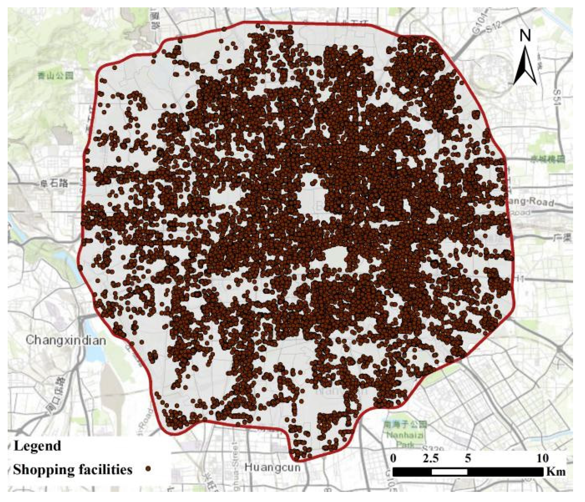
POI (point of interest) is called point of interest, also known as information points. The data used in this paper is collected from Baidu map open platform in 2019 [38], which is classified into three levels. Guided by the retail classification standard in the Industrial classification for national economic activities (GB/T 4754-2017), we select six secondary levels that are most closely related to residents’ daily shopping activities under the primary classification of POI data “shopping facilities” as our research data. They are clothing\shoes\hats\leather stores, personal goods\cosmetics stores, sporting goods stores, cultural goods stores, specialty stores, and shopping-related places. Each POI data contains name, category, address, longitude, latitude and administrative region information, this paper exhibits the distribution of shopping stores in Figure 2.
2.
Real-time travel time
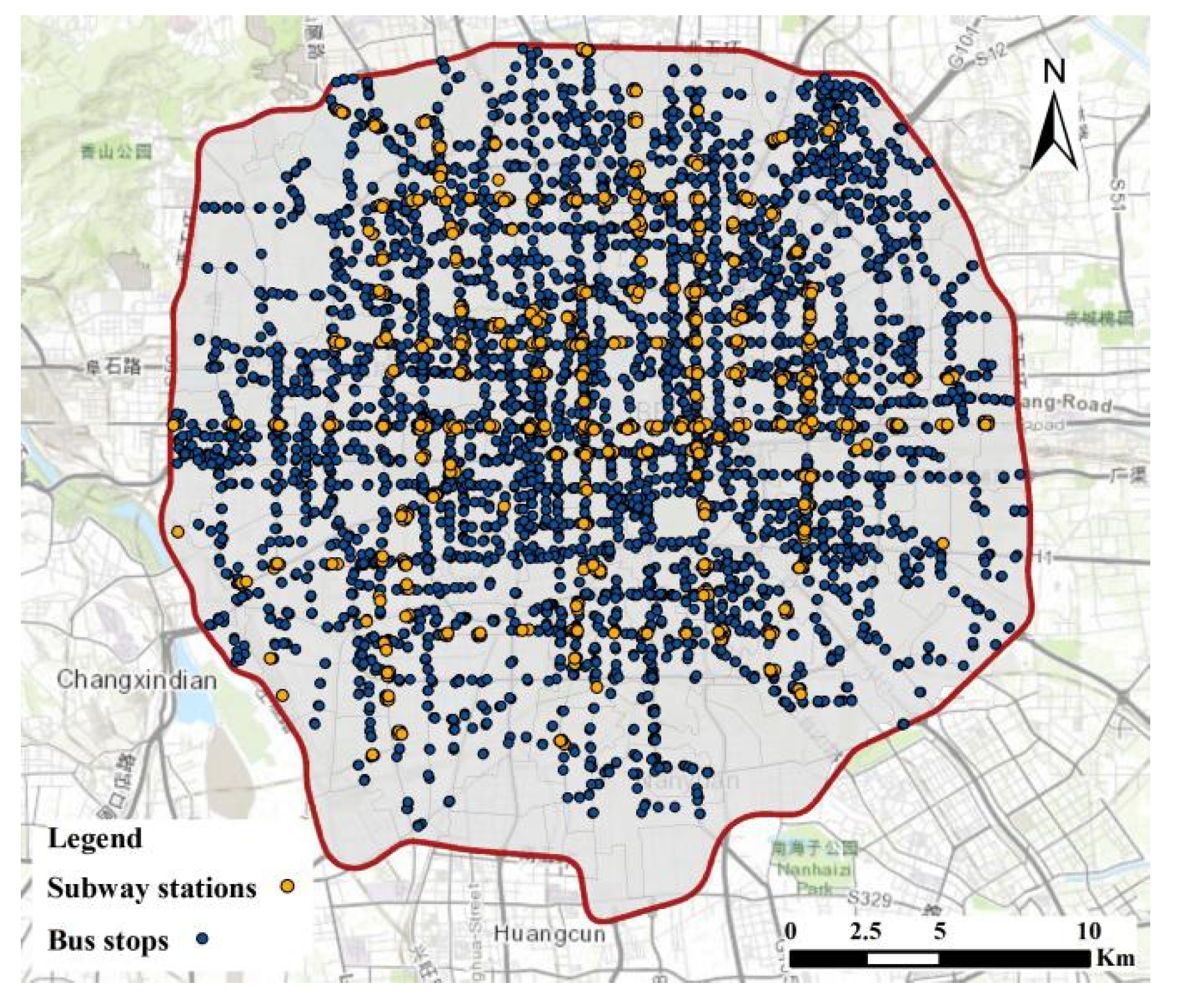
In this paper, real-time travel time is selected as travel cost to measure accessibility. Supported by machine learning and big data, Internet maps can simulate current travel times between two places based on road conditions and large amounts of historical data. Baidu map has become a popular navigation service provider in China with its mature technology. It provides an open API for users to obtain path planning in batch. The real-time travel time in this paper contains driving, public transportation and walking mode. The detailed information will be introduced in Section 3.1. Since the use of public transport is greatly affected by the distribution of public transport stations, this paper exhibits the distribution of bus stations and subway stations in Figure 3.

2.3. Data Preprocessing

The spatial clustering algorithm is a frequently-used method to identify geographical clusters [39]. According to the existing analysis of various clustering algorithms, this paper adopts the Cluster by fast search and find of density peaks (CFSFDP) algorithm, proposed by Alex Rodriguez et al., in 2014, to identify clusters [40]. This literature holds that the core of density based peak clustering algorithm is the characterization of clustering center, and the ideal cluster center needs to meet two conditions: (1) The clustering center has the local maximum density, that is, surrounded by points with lower density; (2) The relative distance between one cluster center and its higher local density points is far. In order to find the ideal clustering center, two values are calculated for each data point, one is the local density ρ i of data point i , and the other is the nearest distance δ i which is used to describe the distance between data point i and the nearest data point with a higher local density. The algorithm process includes: (1) calculating the local density and the nearest distance; (2) determining the cluster center; (3) assigning the remaining points to the cluster represented by the nearest cluster center.
Based on existing studies and the shortcomings of the CFSFDP algorithm, we carry out some thoughts with geographical significance in the original formula and make some settings for its parameters. (1) The calculation of ρ i in view of the concept of k-nearest neighbor (KNN), we reselect the local density calculation method with reference to the research of Xie et al. [41], let ρ i = j K I exp ( d i j ) . Where, d i j is the distance between point i and point j , K i is the number of the selected adjacent point of point i . (2) Search for candidate clustering centers. The candidate cluster centers are selected by quantitative calculation. First, defining variable γ i * and making it equal to the result of normalized ρ i multiply normalized δ i . Then, descending γ i * to create the “ γ i * descending arrangement diagram”. Last, the method proposed by Wang et al., to automatically obtain the cluster center by using the change of slope difference was introduced for operation [42]. (3) Determine the true cluster center. In the set of candidate cluster centers, points that should belong to the same cluster may be identified as candidate cluster centers, respectively, so it is necessary to filter the candidate cluster centers. Here, we set a truncation distance D, which represents the shortest distance between two candidate clustering centers. Huff (1963) pointed out [43] that the main object of any trade area analysis is consumers rather than retail enterprises. Therefore, the setting of the D centers should consider people’s shopping characteristics. Traditionally, the personal shopping behavior uses a walking time of 300 m or less than 6 min [40,44]. Considering the above information, D is set to 500 m. Then, the maximum point of γ i * in the candidate cluster centers is taken as the first true cluster center. If there are other candidate cluster centers within its D distance, they can be deleted from the candidate cluster center set. Other candidate clustering centers will be screened in descending order of γ i * to accurately select the true clustering centers.
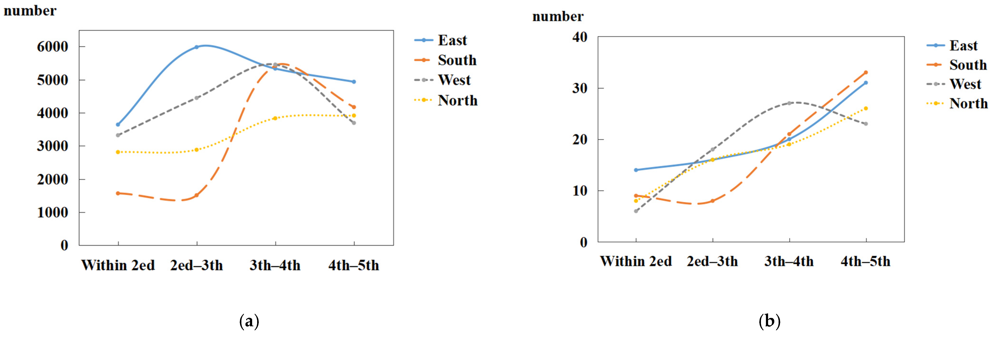
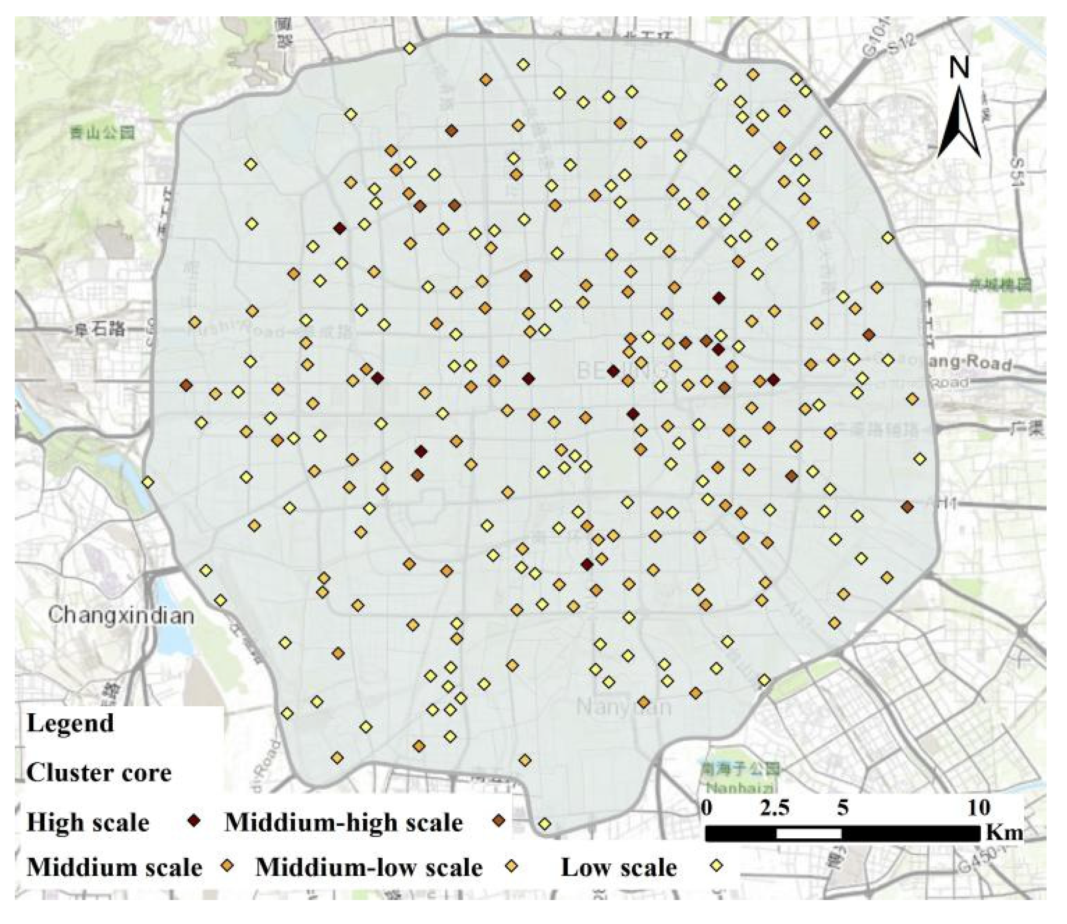
Using the CFSFDP algorithm, we obtain the cluster of shopping stores. For K in local density ρ i , it is set to 93 according to the spatial distribution characteristics of data points. A total of 295 clusters were formed, which were unevenly distributed in the whole study area. By comparing the number of clusters with the number of original data points, it is found that the variation trend of the two numbers is very different in each direction and all kinds of ring roads (The related pictures are shown in Appendix A, Figure A1). This phenomenon reflects the difference of cluster scale. Therefore, the clusters are classified according to the cluster scale using Natural Breaks (Jenks), and GVF (The Goodness of Variance Fit) is used to determine the best classification number (Figure A2 in Appendix A). Finally, clusters are divided into five categories. Its spatial distribution is shown in Figure 4 below. In order to show the spatial distribution of clusters better and clearly present the grade differences of clusters at different points, and avoid visual divergence caused by data clutter, we present clusters in the form of cluster center after classification.

3. Methods

3.1. Travel Time Analysis

Internet map is a platform integrating GIS, GPS and location-based services (LBS). Supported by the digital map and dynamic road conditions, Internet map provides users with intelligent and accurate navigation and other tourism-related services. In addition, Internet maps can generate intelligent route plans, derive travel times based on complex road network features (such as speed limits, restricted turns, overpasses, underpasses, waiting times) and historical data. The results are more objective and reliable.
This paper takes the facility cluster as the research object to measure the accessibility, so the travel time takes the TAZ centroid as the original point (O) and the cluster-center as the destination point (D), which are represented by TAZ centroid and cluster center, respectively. We acquire the travel time pairs between TAZ and the facility cluster. Specifically, according to the existing literature and residents’ shopping travel habits [45], we collected the driving travel time, public transport travel time (including underground transportation and ground transportation), and walking travel time of these OD pairs, respectively. Based on these, we first analyze the extreme value and mean value of all OD pairs. Then, the average travel time under each travel mode in the TAZ is calculated, which represents the average travel time from each TAZ to all its reachable clusters. This value can explain the cost consumption of obtaining facility clusters in the study units as is carried out in literature [46], which used travel time between supply and demand points to represent the accessibility of facilities. Its calculation formula is as follows:
AT i = 1 n j n T i , j
where AT is the abbreviation of average travel time, T i , j represents the time from TAZ i to cluster j , and n represents the number of clusters that TAZ i can reach.

3.2. Cluster-Two-Step Floating Catchment Area (C-2SFCA) Method

Derived from the gravity model, the two-step floating catchment area method plays an important role in the accessibility research of various urban public service facilities and is one of the most popular accessibility measurement methods. The two-step floating catchment area method conducts floating catchment area search at facility point and demand point, respectively, taking into account facility service capacity, demand degree of demand point and spatial barrier. Moreover, this method does not need to consider the boundaries of administrative divisions, breaking the barrier between administrative divisions. The evaluation results are more scientific, reasonable and easy to understand. Two following steps have consisted in this method [47].
The first step takes supply point j as the center, searches all demand points k within the catchment area d 0 of j , and dividing the capacity (service capacity) of supply point j by the sum of the population of demand point to calculate the supply/demand ratio V j .
V j = S j d k , j   < d 0 P k × f ( d k , j )
In this expression, S j represents the service capability of supply point j , d is the travel cost, usually represented by time or distance (The former is chosen in this article). d j , i is the travel cost between supply point j and demand point i and d 0 represents the travel threshold. P i is the demand degree of a certain demand point i within the search domain of supply point j . f ( x ) is the distance decay function.
The second step is to search all supply points in the same search domain d 0 for each demand point i , and sum the supply-demand ratio V j of these supply points to obtain the accessibility A i of demand point i .
A i = d i , j < d 0 V j × f ( d i , j )
where, A i is the accessibility value of demand point i . 2SFCA considers that a high A i value indicates that the demand point i has higher accessibility.
As one of the most popular methods to measure accessibility, the two-step floating catchment area method is widely used in the research of service facilities such as hospitals, schools, parks and scenic spots. In the facilities research, facility centroid point is usually used instead of facility whole area, or the entry point of facility surface edge is used as facility point. In the calculation, the 2SFCA algorithm considers that the facility is accessible only when the point can be reached within the preset resident travel threshold. However, there are obvious differences between shopping stores and hospitals, parks and other facilities, which are reflected in two aspects: (1) as described in Section 1, from the perspective of residents’ behavior towards the use of facilities, residents often choose one at a time when they need to go to medical facilities, scenic spots, while when they go to shopping facilities, residents’ travel habits are that they will go to multiple places in one travel; (2) Compared with medical facilities, scenic spots and other facilities, shopping facilities are large in number, widely distributed and unevenly distributed in the city. In view of this, it is not appropriate to use a single facility entrance or centroid as a supply point in the study of shopping stores. Combined with the analysis in the introduction, this paper takes the facility cluster as the supply unit to carry out the experiment.
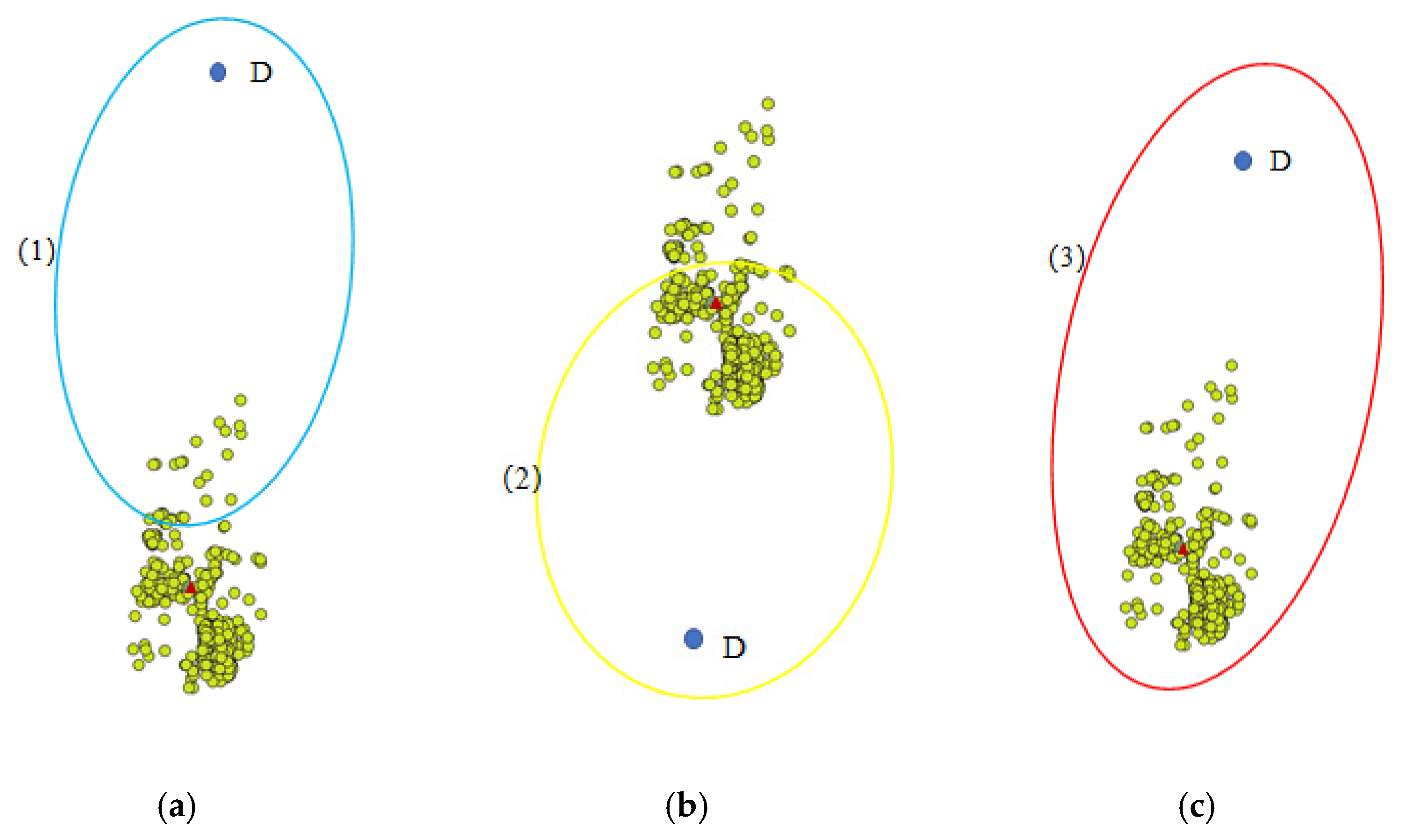
Under the perspective of the cluster, according to the residents’ shopping habits, when they can reach a store in a cluster, the shopping activity can be started. In addition, residents can obtain all the service functions of the cluster in the whole shopping process. So we set that when residents reach the scope of the cluster, they can enjoy the whole service capacity of the cluster. It is not necessary to include the cluster center or the entire cluster within the travel threshold. Figure 5 is a conceptual mapping to illustrate this. (1), (2) and (3) in Figure 5, respectively, represent the case that the cluster can be reached but not to the center within the travel threshold range, the case that the center can be reached but not fully covered by the cluster within the range, and the case that a certain cluster can be completely covered. In this paper, we all believe that demand point D can obtain all the service capabilities of the cluster in three cases.
Thus, we propose a Cluster-Two-step floating catchment area (C-2SFCA) method. In this method, when searching for the sum of supply/demand ratio of supply points starting from demand points, we no longer aim at the centroid (or center) of the facility point, but at the cluster itself to search all accessible clusters within the preset threshold range. In this paper, the travel threshold is defined by the travel time, so the reachable range within the trip threshold is essentially an isochronous circle range. In order to complete the above ideas, isochronous cycle data is introduced into the C-2SFDP method. Clusters falling within the isochronous circle are regarded as completely reachable whether they reach the cluster center or not. Secondly, in the research part of cluster generation, we classify the clusters based on the cluster scale. According to the characteristics of each level of clusters after classification, there should be differences in distance decay characteristics, which are reflected in the calculation formula, that is, in the decay function. On the basis of the obtained real-time travel time, we defined three travel modes: driving, public transport and walking. The improved formula is as follows:
Step 1: calculate the supply-demand ratio,
V j = S j d k , j < d 0 P k × f ( d k , j )
d 0 changes according to the change of travel mode. S is the number of shopping stores in the cluster j . P i is expressed as the population of demand point i .
Step 2: sum the supply and demand ratio and calculate the accessibility,
A i = V j × f ( d i , j ) = S j × f ( d i , j ) d k , j < d 0 P k × f ( d k , j )     { j | j   C i r c l e d 0 0 }

4. Analysis and Results

4.1. The Analysis of Travel Time

4.1.1. Travel Time between OD Paris

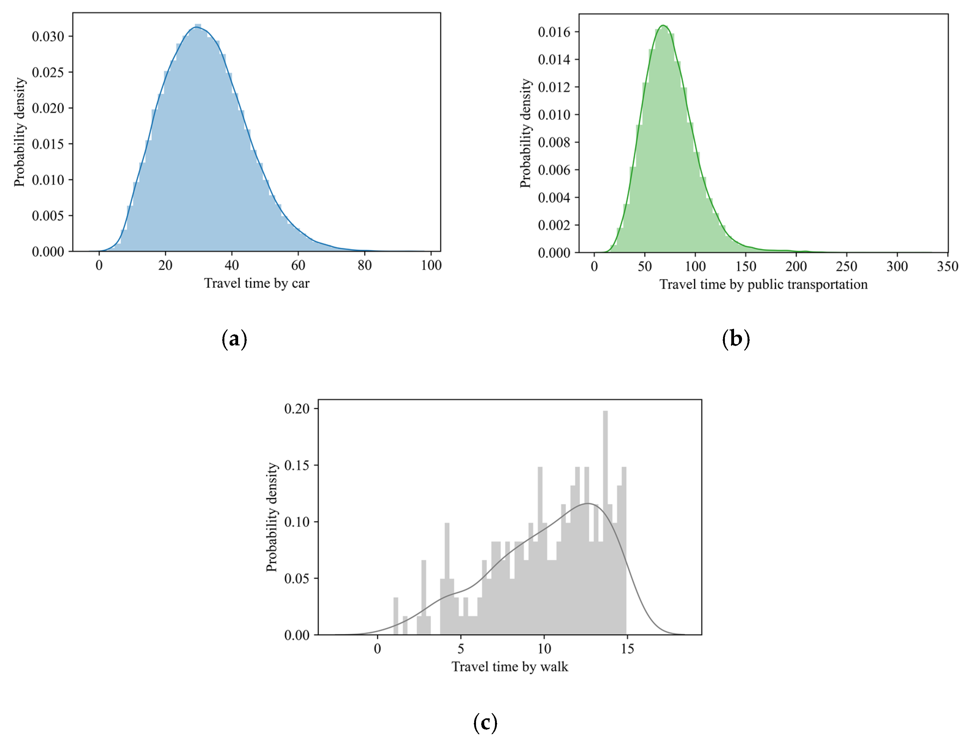
Taking the demand point (traffic analysis zone centroid) as the starting point (O point) and each supply point (cluster) as an endpoint (D point), this paper obtained the travel time pairs between traffic analysis zone and facility cluster, with a total of 82,600 pairs. Travel time is an essential factor affecting residents’ availability of facilities, so it is necessary to analyze travel time. We first analyze the travel time between all OD pairs under different travel modes (Figure 6). According to statistics, the average travel time between all obtained OD pairs under driving mode is 31 min, the minimum value is 1 min and the maximum value is 94 min. In contrast, the average travel time of public transport for OD pairs is 75 min, with the minimum value being 10 min and the maximum value being 325 min. It should be mentioned that OD pairs without public transport modes are excluded. In terms of average travel time, the value of public transport is about 2.42 times that of driving, indicating that driving mode has significant advantages in time efficiency. Walking is also a frequently-used travel mode by shopping activities in close distance and the long walking time can not be included in the research scope in this paper. In order to determine a suitable scope, this paper refers to the concept of 15-min life circle proposed in the standard for Standard for urban residential area planning and design (GB-50180-2018). Thus, we collect the travel time of walking mode within 15 min. It can be seen from Figure 6c that most OD pairs are concentrated in 6–15 min, and the peak value is around 13 min.
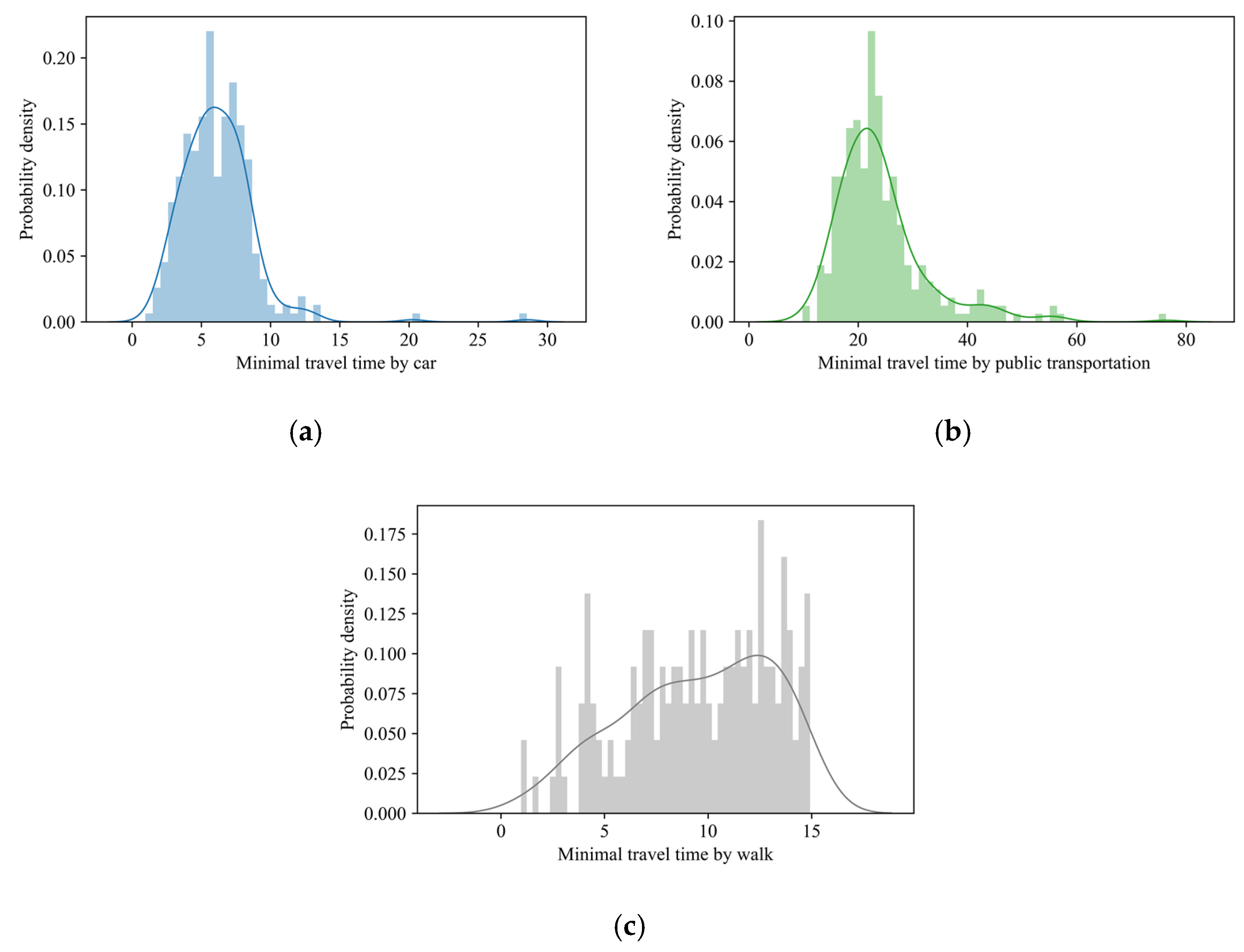
Figure 7 shows the shortest travel time to shopping clusters of each traffic analysis zone under different travel modes., which represents the time cost for the demand point to reach the nearest facility. In the case of driving, the shortest travel time is mainly concentrated within 4–8 min. While the shortest travel time of public transport mainly concentrates in the period of 18–27 min. For walking mode, most of the shortest travel time are within 4–15 min, which is wider than that of Figure 6c. Both graphs in Figure 6 and Figure 7 show an overall trend that probability density increases first and then decreases with time, which can be described as unimodal curve. The difference is that the columns in Figure 6a,b show obvious bell-shaped distribution, and the columns in Figure 6c are basically bell-shaped but flatter. However, in the three graphs of the shortest travel time (Figure 7), with the increase of time, the height variation of columns under each travel mode is not smooth, and there are many mutations. The height of the column represents the probability density in this period and reflects the number of traffic analysis zones. Therefore, there is an obvious difference in the number of traffic analysis zones in adjacent periods in the shortest travel time.

4.1.2. The Average Travel Time of Traffic Analysis Zones

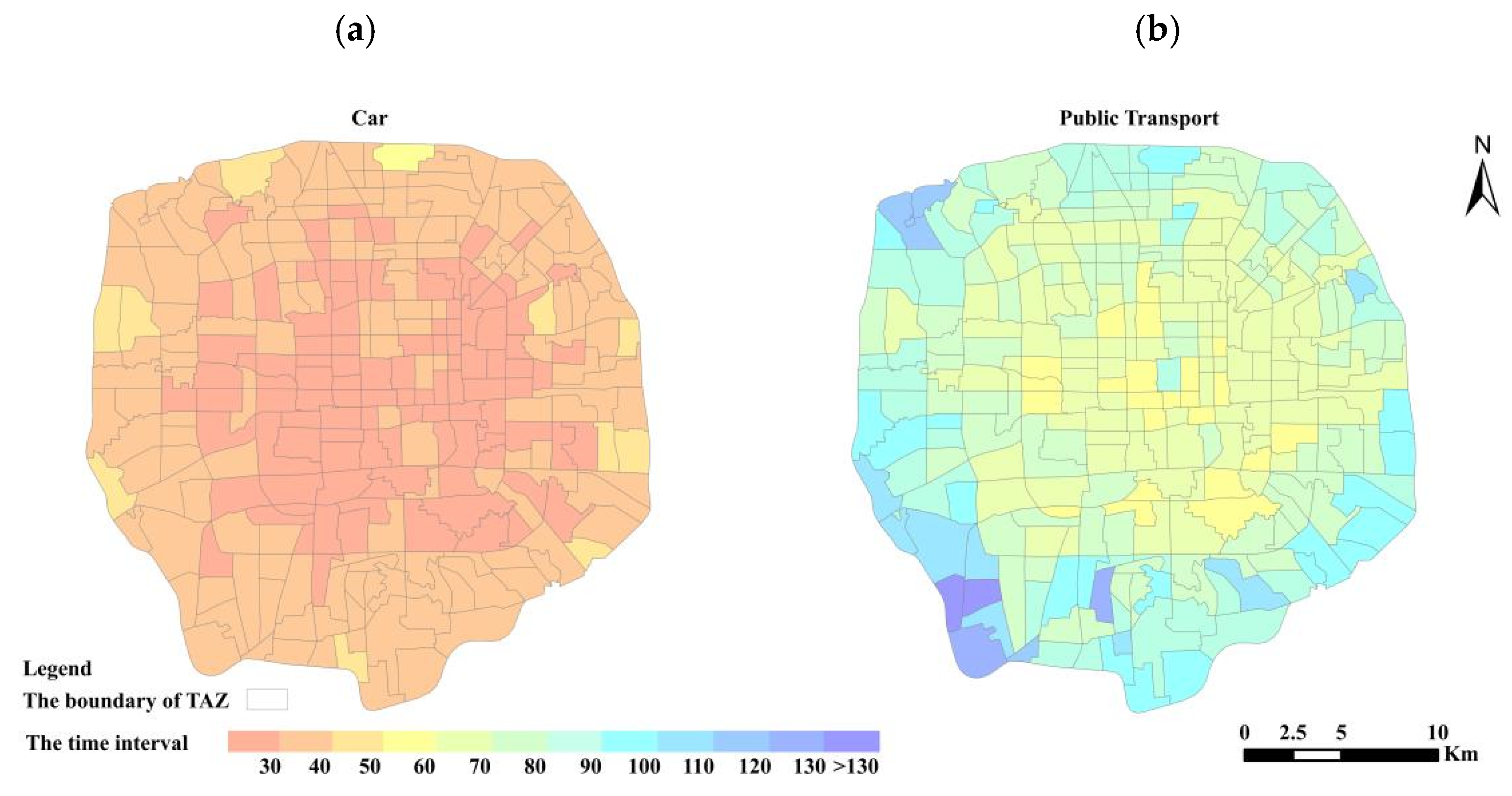
The average travel time on each traffic analysis zone is calculated to study the travel cost from the view of traffic analysis zones. This time represents the average time from each traffic analysis zone to all available shopping facilities clusters. Figure 5 shows the spatial distribution of the average real-time travel time of each research unit under different travel modes in a visual form. The left graph shows the calculated average driving time, and the right graph is calculated from the real-time travel time of public transport. This set of graphs is divided into 13 bands, starting from 30 min and taking 10 min as an interval. The color from warm to cold means the gradual increase of the average travel time. As can be seen from Figure 8, the variation of average travel time is basically distributed in a concentric circle, showing that the time period gradually increases from the center to the periphery in both modes of transportation. The average travel time of the traffic analysis zone under driving mode is within 60 min. Most of time periods are concentrated between 20 and 40 min (the cumulative probability is 0 within 20 min, while when the travel time reaches 40 min, the cumulative probability is about 96%). Under the mode of public transport, the average travel time range mainly concentrated within 60–90 min, with a large span and long tail distribution. The time period with the largest proportion is 60–70 min, accounting for 35.71% of the total number of TAZs. Followed by the time period 70–80 and 80–90, accounting for 28.57% and 14.64%, respectively. The proportion after 100 min is less than 5%. Therefore, although the overall span of time is larger, it is basically concentrated.
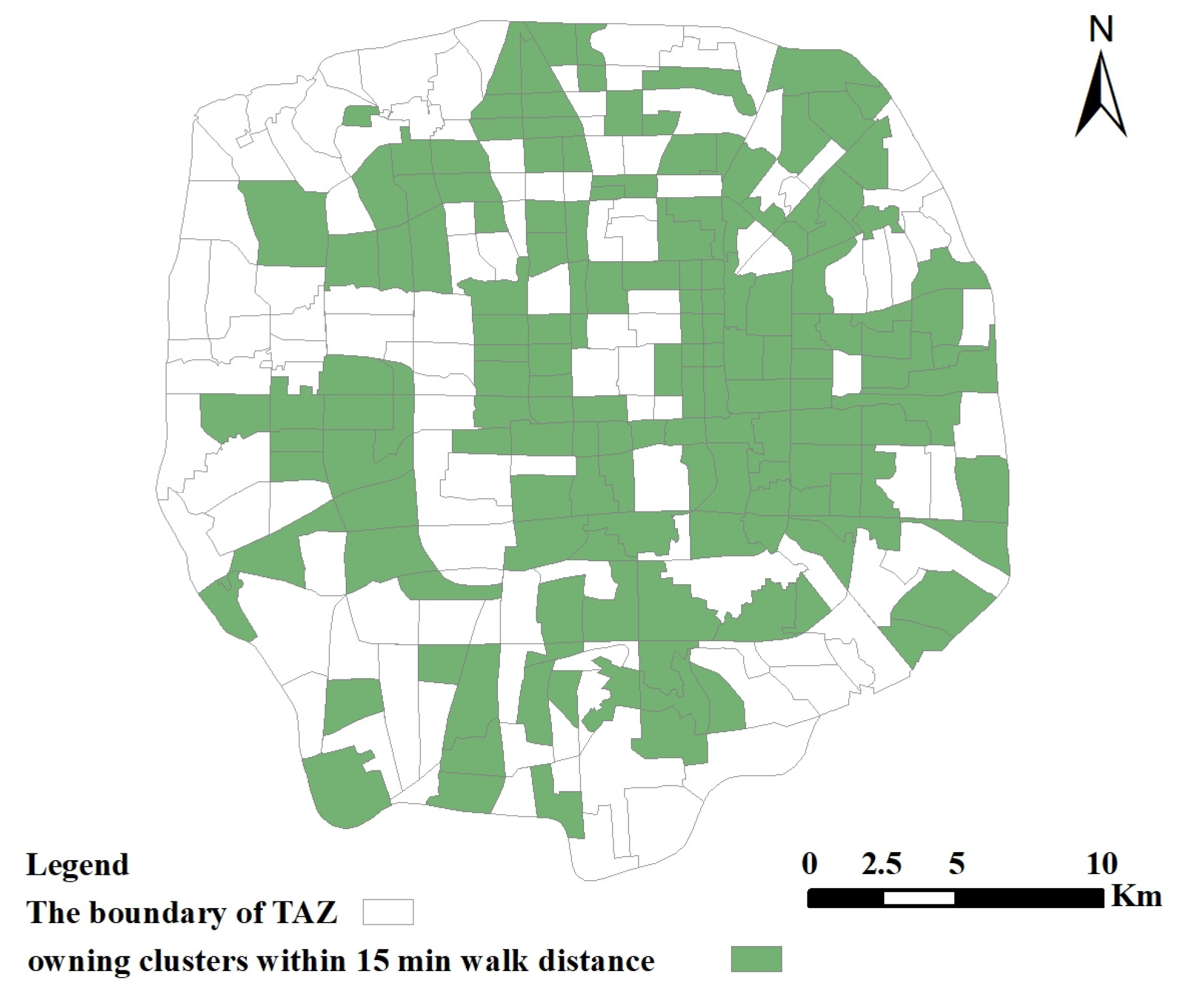
Only traffic analysis zones that can reach a facility cluster within 15 min walking travel time are studied. Since the number of research units in this time period is relatively small and this time range is short, the calculation of the mean value is not significant. Thus, here just demonstrates research units that can reach the cluster within 15 min of walking (Figure 9), which are unevenly distributed, mostly in the eastern and central areas within the Fifth Ring Road, and the scatter appears in a clump form.

4.2. Accessibility Results under Different Travel Modes

According to the distribution nature of shopping stores and characteristics of residents’ usage, this paper proposes a method called C-2SFCA, which from the perspective of facility cluster to study, and adds isochronal data into the traditional 2SFCA model. It is used to calculate the accessibility between traffic analysis zones and shopping clusters with the obtained real-time travel time. After making statistics on real-time travel time and referring to existing literature [46], we choose the average travel time between all OD pairs as the travel threshold value in driving and public transportation. Since it can represent the average travel situation of the research object from an overall perspective, while it takes 15 min for walking mode. The clusters have been divided into 5 levels in Section 2.3. The area represented by clusters of level 5 not only has a shopping function, but also has the nature of similar scenic spot due to its popularity, such as Sanlitun, Xidan and Wangfujing. The demand of residents will ignore the long-distance for this level due to the nature of class scenic spot. Therefore, we do not do distance decay for this level, and the Gaussian function is selected as the distance decay function of the remaining levels by referring to the existing literature [48].
We obtain the accessibility results of driving (Figure 10), public transportation (Figure 11) and walking (Figure 12), respectively. For giving consideration to efficiency and showing difference better at the same time, accessibility results are divided into four grades according to GVF method: high-accessibility, medium-high-accessibility, medium-accessibility and low-accessibility. The dark color indicates high accessibility and light color indicates low. The value indicates the number of facilities per 10,000 people.
Figure 10 shows the spatial distribution of accessibility results under the driving model and the statistical result of accessibility frequency at each grade. The number of traffic analysis zones corresponding to the four accessibility grades is relatively uniform, with medium-high and high grades slightly higher and low grades slightly lower. In the corresponding distribution map, the zonal regularity of accessibility distribution of the four grades is poor, which may be related to the different congestion degrees of each road at the same time. The high-accessibility region is distributed in a decentralized state. Compared with Figure 3, the relatively high-level cluster is generally distributed around them. In the study area, the number of high-accessibility areas in the south is significantly less than that in the north, and the number of high-accessibility areas in the east is significantly more than that in the west, which is similar to the result of cluster number distribution and the economic development of urban Beijing. There is a belt of high accessibility in the study area center, probably due to proximity to the urban motorway. Most of the low-accessibility areas are distributed between the Fourth ring and Fifth Ring Road, especially in the northwest, north and northeast. From the perspective of cluster distribution to analyze this feature, clusters in the northwest and north directions are rare and low-grade, while clusters in the northeast direction are relatively dense but have a relatively large population, resulting in low accessibility. By comparing the accessibility of public transport, it is discovered that the number of facilities available for driving accessibility per 10,000 people is relatively low. For example, the accessibility value range of high-accessibility of driving mode is 77–103 while that of public transport is 118–152. This is because the driving mode can obtain a larger travel range under the travel threshold. This means that more residents will become service objects, leading to a lower supply-demand ratio and ultimately lower accessibility.
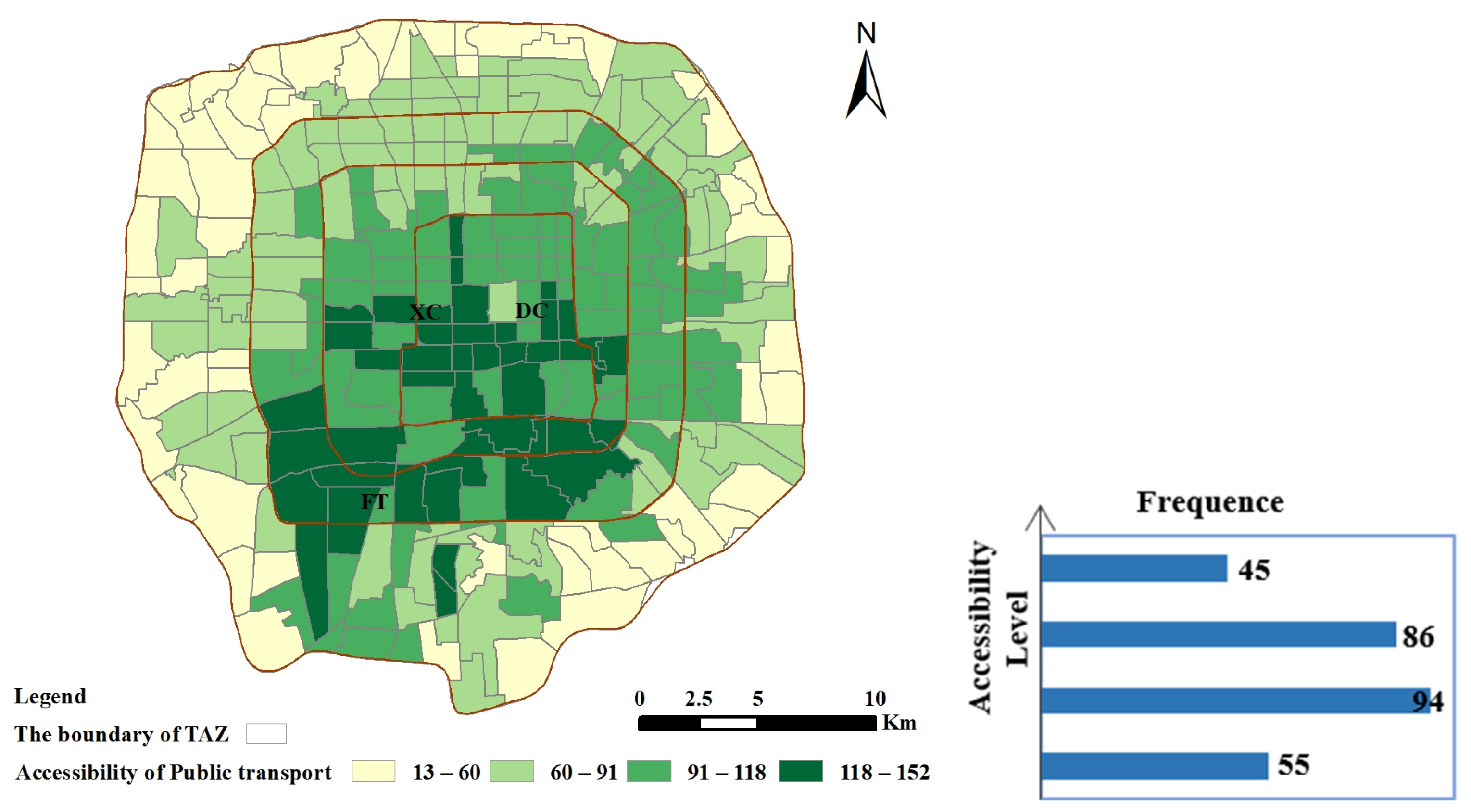
Compared with the driving mode, the difference in the number of traffic analysis zones corresponding to the four accessibility grades becomes larger in the result of public transport. The maximum number is in medium-accessibility with the number of 94, and the minimum number is in high-accessibility with the number of 43, which is 23 less than the driving mode. Figure 11 shows the spatial distribution of public transport modes, with obvious accessibility distribution characteristics. It is distributed in an obvious ring form, and the accessibility gradually decreases from the center to the periphery of the ring. High accessibility areas are mainly concentrated in Xicheng district, Dongcheng District, Fengtai District and their surrounding areas. Accessibility in public transport mode is closely related to the distribution of transport routes. Dense distribution of public transport routes leads to stronger accessibility and vice versa. Dongcheng and Xicheng districts are the agelong districts of Beijing and have the most intensive public transportation lines. Although Fengtai district does not have dense public transport stations but still has a large number of high-accessibility areas, which can be explained from two perspectives. The high-accessibility areas in the southwest of Fengtai are related to the low population density, while the high-accessibility areas in the east of Fengtai are due to the distribution of dense supply facilities.
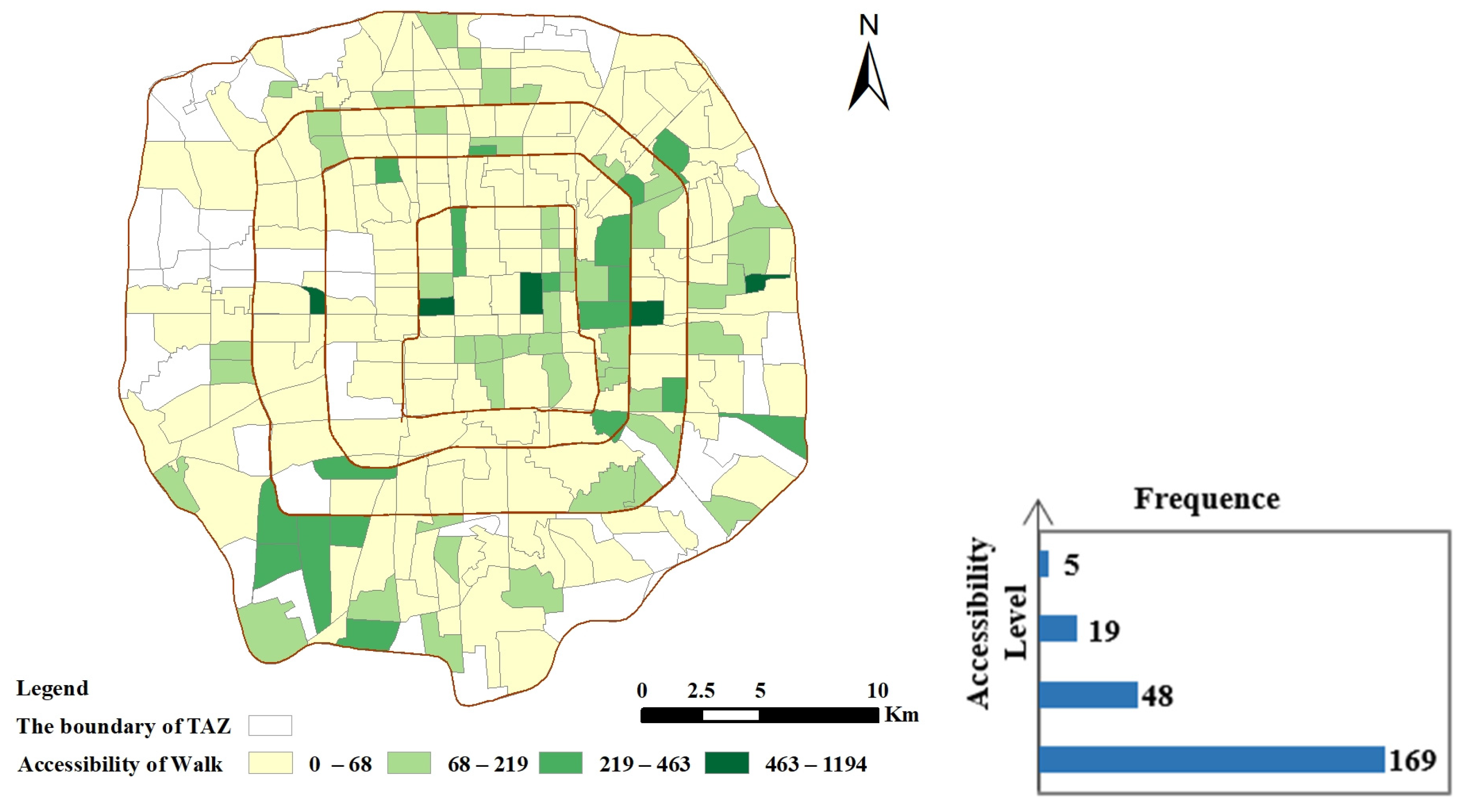
In the result of walking accessibility, the number of traffic analysis zones corresponding to the four accessibility grades is significantly different. The highest number is low-accessibility grade, accounting for 169 traffic analysis zones, while the lowest number is high-accessibility grade, accounting for only 5 traffic analysis zones. On the distribution map, the high-accessibility areas are scattered. Medium-high-accessibility, medium-accessibility are mainly distributed in the eastern part of the study area, and slightly distribute in the north and southwest part of the study area. Low-accessibility regions are distributed all over the whole region. The value difference of accessibility of walking is more obvious than of public transport, with the lowest accessibility value being 0 and the highest being 1193. Exploring the reasons, the distribution of walking accessibility is less affected by road conditions. It mainly relates to the number of nearby facilities, the distance between facilities and the number of people, among which the first two are the most important factors. The walking travel threshold is 15 min. When the traffic analysis zone is far from the supply facility, the accessibility is 0 (blank position in Figure 12), while when the traffic analysis zone is in or close with a high-facility-density area, the accessibility value will be very high. Compared with Figure 9, there are fewer blank areas in Figure 12. This is because the time described in Figure 9 is the time from the traffic analysis zones to the cluster center, while Figure 12 is the result of adding the isochronous circle idea. As long as the cluster can be reached within the time threshold, it is considered that the cluster service capability can be obtained, which is more in line with the actual situation of shopping activities. Therefore, there are fewer research units.

4.3. Further Analysis of Spatial Distribution of Accessibility

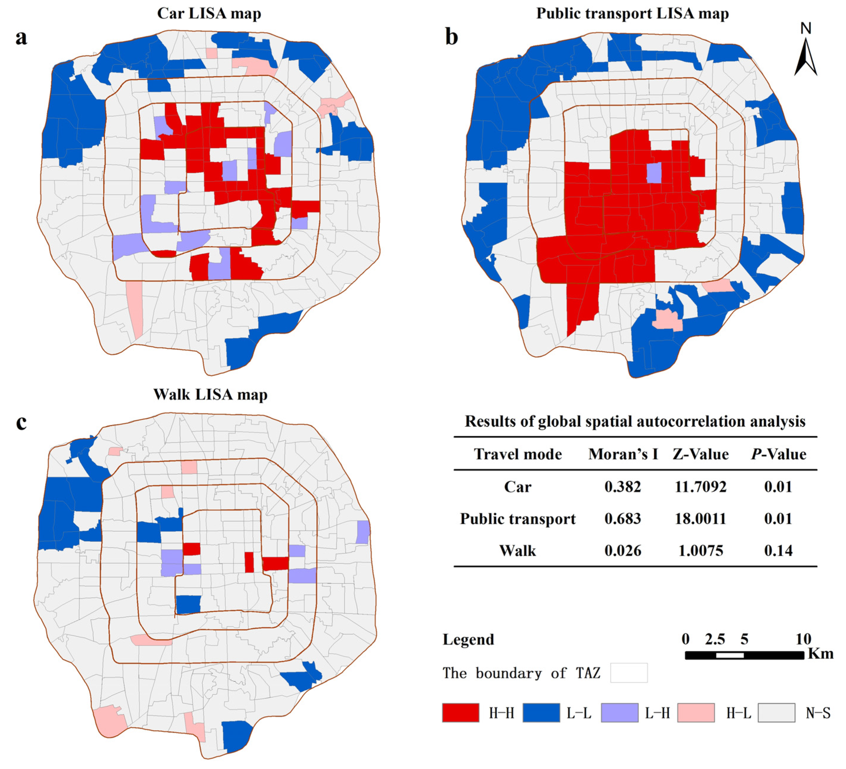
To further analyze the difference of spatial distribution of accessibility, we conduct spatial auto-correlation analysis on accessibility values, respectively [49]. This is carried out on the software GeoDa. The table in Figure 13 is the result of global spatial autocorrelation. Although Moran’s I value is greater than 0 in all three modes, the value in walking mode is 0.026, close to 0, and Z < 1.96, p > 0.05, which fails the Z test. Therefore, there is no global spatial autocorrelation, that is, the spatial distribution of research units with high accessibility and low accessibility is relatively random. The Z value of driving and public transport travel modes is greater than 1.96, and the calculation results pass the Z value test (p-value is 0.01 < 0.05). It can be seen that in these two modes, the accessibility in the study area is spatially positively correlated, which means that the accessibility results under these two travel modes are that the high accessibility unit is adjacent to the high accessibility unit, and the low accessibility unit is adjacent to the low accessibility unit.
Figure 13 shows the formed Local Indication of Spatial Association cluster map (LISA). In the car driving mode, the H-H value is mainly concentrated within the Third Ring Road, which is basically distributed along the northwest-southeast diagonal, most of the L-L values are distributed in the north of the fourth ring to the fifth ring area. In the LISA map formed by the accessibility results of public transport mode, the spatial differentiation characteristics of the H-H area and L-L area are obvious. H-H area is distributed in the center of the study area and extends to the southwest, L-L area is distributed in the peripheral research units, the transition zone between H-H and L-L was no-significant area. In the LISA map of walking mode, the distribution of high-value area, low-value area and outliers are relatively scattered, and there are many no significant areas.

4.4. Comparison with Traditional 2SFCA Method

In order to verify the improved method and the new perspective, in this section, a comparison is made between the results of the proposed C-2SFCA and that of the traditional 2SFCA. The difference between two methods is whether the centroid (or center) of the facility point is aimed at.
Figure 14 visualizes the differences of the three transport modes under the two methods. The values represent the result of our C-2SFCA method minus the result of the traditional 2SFCA method and are divided into five grades. A quick detailed comparison among these three types suggests some apparent differences between the accessibility by C-2SFCA and that by traditional 2SFCA. The difference value is more than 0 for most locations under three types, indicating that the accessibility by C-2SFCA is higher than that of traditional 2SFCA. This is because, compared to traditional 2SFCA, the C-2SFCA no longer aims at the centroid (or center) of the facility point, but at the cluster itself to search all accessible clusters within the preset threshold range, which is not restricted by centroid of the facility point. Therefore, the disparity of accessibility by C-2SFCA is larger than that by traditional 2SFCA, and the traditional methods would underestimate the disparities of accessibility. In particular, we find some interesting situations, among the three transport modes, the walking mode shows the greatest accessibility differences, with the lowest value being -6 and the highest being 353. The main reason for this result is that walking mode is less affected by road conditions; meanwhile, the C-2SFCA method which aims at the cluster itself to search all accessible clusters strengthens the accessibility difference.

5. Discussion

Travel time in real traffic is more reliable than a fixed distance between two places. Internet maps represented by Baidu Map provide users with objective travel times taking into account road congestion and traffic flow. So we choose this travel time as the cost metric. No matter the travel time of all OD pairs or of the shortest travel time, it can be found that the driving travel mode has an obvious time advantage. The statistical results of the average travel time in the traffic analysis zones of the driving mode are concentrated in 20–40 min, while the public transport mode is concentrated in 60–90 min. Thus, we can say that driving mode has an obvious space-time compression effect. This finding is similar to previous statistical features of travel time [51]. In the study area, the travel time presents a spatial feature of increasing from the center to the periphery. Walking is a travel mode limited by distance, so it is also included in this study because it is flexible, environmental-friendly and can be used as a form of exercise. Most of the study units can reach at least one store cluster within 15 min. Spatially, the distribution of reachable research units is uneven, and its distribution state is mainly affected by the spatial distribution of clusters.
Based on the collected real-time travel time, the proposed C-2SFCA method is implemented to measure the accessibility under the driving, public transport and walking modes under different travel thresholds. Firstly, it can be seen from the result figures that there are significant differences in the accessibility spatial pattern of shopping facilities under different travel modes. Even in the same mode, different area also has different accessibility value. Such as in car driving mode and public transport mode, the heterogeneity of their results deeply reflects the unbalanced distribution of urban transportation facilities. In addition, the result of walking indicates that cluster distribution is also an important factor that determines the accessibility of shopping stores. Moreover, in these three results, there are similar low-value aggregation areas, such as the northwest corner of the study area. This is because there are large parks around, which belong to landscape land. Therefore, there is a lack of shopping facilities, resulting in low accessibility. To sum up, in terms of shopping activities, facility density and transportation system are two important influencing factors. These results suggest that accessibility requires careful consideration rather than a simple process [14].
In the three LISA maps, the accessibility of peripheral areas is very low. To improve this situation from the perspective of facility configuration, the needs of residents in peripheral areas should be taken into account. Due to the high housing price in the city center, residents generally choose to live in the peripheral areas resulting that shopping demand will also increase in the peripheral areas. In this area, shopping stores can be selected near traffic stations and distributed in an aggregated form. This not only considers the convenience of public transport, but also expands the service area by virtue of the convenience of public transport. In addition, the low accessibility aggregation areas in the public transport LISA map are obviously distributed in a ring around the periphery. From the perspective of the transportation system, the relevant departments should pay attention to improving the traffic accessibility of these areas.

6. Conclusions

In cities, there are a large number of shopping stores with uneven spatial distribution, and residents’ use behavior of shopping facilities is different from other urban facilities. Therefore, we try to find a method to measure its accessibility. In this study, we propose a C-2SFCA method and apply it to the identification of spatial differences in accessibility. In the method, real-time travel data based on Baidu map is used as an accessibility evaluation factor for estimate, and traffic analysis zones divided according to main roads on the basis of sub-district administrative units are used as research units. Since travel time plays an important role in accessibility measurement, we firstly analyze real-time travel time from the perspective of OD pair and traffic analysis zones before implementing C-2SFCA, and determine the travel threshold in C-2SFCA according to the analysis results. The accessibility results show that there are significant differences in accessibility between different travel modes and between different regions under the same travel mode. The results are helpful for the identification of urban areas that need planning support. Urban planners and policymakers can promote spatial equity of urban public facilities by allocating shopping resources more reasonable through urban planning. In particular, the C-2SFCA method proposed in this study provides a deeper understanding for the spatial allocation of urban public facilities, which could be used as a reference for the spatial accessibility to other public facilities (e.g., markets and libraries).
However, its limitations should be recognized. First of all, due to the uneven distribution of facilities themselves, there will be a gap in the size of clusters formed, especially in peripheral areas. That may have affected the outcome. In the next research, we can do further research on the identification method. Secondly, although three types of travel modes are considered, we calculate the accessibility of a certain transportation mode separately. This is far different from the actual situation. The real travel situation is a mixed mode, not a single one. A variety of travel modes can be selected, which are related to the economic status and willingness of urban residents. This is a complex issue that deserves further discussion in the future. Thirdly, this paper selects six types of facilities that are most closely related to residents’ daily shopping activities and considers them as the same degree of demand. However, the diversity of residents’ preferences, age, income, experience and work demand will all have an impact on the selection of types, which can be used as a future research direction, combining with age, season, social needs and other non-spatial information for in-depth discussion. The last, the edge effect is not considered in this study. Thus, the accessibility value might be underestimated because residents can access to stores which just outside of the study area but can serve the study area under the time threshold. However, it is worth mentioning that such underestimation is almost global, which is only reflected in the size of the value, and has little impact on the variation of the overall accessibility distribution.

Author Contributions

Conceptualization, J.Q.; methodology, J.Q. and D.Y.; conceived the idea, J.Q. and S.L.; writing—original draft preparation J.Q.; writing—review and editing, S.L. and H.J.; funding acquisition, J.Z.; supervision, J.Z. All authors have read and agreed to the published version of the manuscript.

Funding

This research was funded by National Nature Science Foundation of China (grant number 41971331).

Institutional Review Board Statement

Not applicable.

Informed Consent Statement

Not applicable.

Data Availability Statement

Not applicable.

Conflicts of Interest

The authors declare no conflict of interest.

Appendix A

Figure A1. The variation trend of cluster number and original data number in each direction and all kinds of ring road ((a) Cluster number; (b) Original data number).
Sustainability 14 02310 g0a1
Figure A2. GVF values under different classification numbers.
Sustainability 14 02310 g0a2

References

  1. Lee, G.; Hong, I. Measuring spatial accessibility in the context of spatial disparity between demand and supply of urban park service. Landsc. Urban Plan. 2013, 119, 85–90. [Google Scholar] [CrossRef]
  2. Guy, C.M. The assessment of access to local shopping opportunities: A comparison of accessibility measures. Environ. Plan. B Plan. Des. 1983, l0, 219–237. [Google Scholar] [CrossRef]
  3. Hansen, W.G. How accessibility shapes land use. J. Am. Inst. Plann. 1959, 25, 73–76. [Google Scholar] [CrossRef]
  4. Tao, Z.L.; Cheng, Y.; Liu, J. Hierarchical two-step floating catchment area (2sfca) method: Measuring the spatial accessibility to hierarchical healthcare facilities in Shenzhen, China. Int. J. Equity Health. 2020, 19, 164. [Google Scholar] [CrossRef] [PubMed]
  5. Khan, A.A. An integrated approach to measuring potential spatial access to health care services. Socioecon. Plann Sci. 1992, 26, 275–287. [Google Scholar] [CrossRef]
  6. Dalvi, M.Q.; Martin, K.M. The measurement of accessibility: Some preliminary results. Transportation 1976, 5, 17–42. [Google Scholar] [CrossRef]
  7. Berechman, J. Transportation, temporal, and spatial components of accessibility, by Lawrence, D. Burns. Geogr. Anal. 2010, 13, 185–187. [Google Scholar] [CrossRef]
  8. Su, S.L.; Li, Z.K.; Xu, M.Y. A geo-big data approach to intra-urban food deserts: Transit-varying accessibility, social inequalities, and implications for urban planning. Habitat Int. 2017, 64, 22–40. [Google Scholar] [CrossRef]
  9. Charreire, H.; Casey, R.; Salze, P. Measuring the food environment using geographical information systems: A methodological review. Public Health Nutr. 2010, 13, 1773–1785. [Google Scholar] [CrossRef]
  10. Shearer, C.; Rainham, D.; Blanchard, C. Measuring food availability and accessibility among adolescents: Moving beyond the neighbourhood boundary. Soc. Sci. Med. 2015, 133, 322–330. [Google Scholar] [CrossRef]
  11. Zhang, L.; Zhou, J.; Hui, C.M. Which types of shopping malls affect housing prices? From the perspective of spatial accessibility. Habitat Int. 2020, 96, 102118. [Google Scholar] [CrossRef]
  12. Zhou, J.T. The Effects of Spatial Accessibility to Shopping Centers on Housing Prices: A Case of Hangzhou, China. Shopping Center Accessibility on Housing Prices. Ph.D. Thesis, Zhejiang University, Hangzhou, China, 2019. [Google Scholar]
  13. Lu, Y.W.; Hong, F.; Yan, K.W. Site selection of retail shops based on spatial accessibility and hybrid bp neural network. ISPRS Int. Geo-Inf. 2018, 7, 202. [Google Scholar]
  14. Ner, Z. Retail city: The relationship between place attractiveness and accessibility to shops. Work. Pap. Ser. 2015, 12, 1–20. [Google Scholar] [CrossRef] [Green Version]
  15. Arranz-López, A.; Soria-Lara, J.A.; Pueyo-Campos, N. Social and spatial equity effects of non-motorised accessibility to retail. Cities 2019, 86, 71–82. [Google Scholar] [CrossRef] [Green Version]
  16. Morris, J.M.; Dumble, P.L.; Wigan, M.R. Accessibility indicators for transport planning. Transport. Res. Part A Gen. 1979, 13, 91–109. [Google Scholar] [CrossRef]
  17. Batty, M. Urban Modelling: Algorithms, Calibrations, Predictions; Cambridge University Press: Cambridge, UK, 1976. [Google Scholar]
  18. Deboosere, R.; El-Geneidy, A. Evaluating equity and accessibility to jobs by public transport across Canada. J. Transp. Geogr. 2018, 73, 54–63. [Google Scholar] [CrossRef]
  19. Kwan, M.P. Space-time and integral measures of individual accessibility: A comparative analysis using a point-based framework. Geogr. Anal. 2010, 30, 191–216. [Google Scholar] [CrossRef]
  20. Tao, Z.L.; Cheng, Y.; Dai, T.Q. Measuring spatial accessibility to residential care facilities in Beijing. Progr. Geogr. 2014, 33, 616–624. (In Chinese) [Google Scholar]
  21. Widener, M.J. Comparing measures of accessibility to urban supermarkets for transit and auto users. Prof. Geogr. 2017, 69, 362–371. [Google Scholar] [CrossRef]
  22. Handy, S.L.; Clifton, K.J. Local shopping as a strategy for reducing automobile travel. Transportation 2001, 28, 317–346. [Google Scholar] [CrossRef]
  23. Li, A.; Chen, J.; Qian, T.; Zhang, W.; Wang, J. Spatial accessibility to shopping malls in Nanjing, China: Comparative analysis with multiple transportation modes. Chin. Geogr. Sci. 2020, 30, 710–724. [Google Scholar] [CrossRef]
  24. Thornton, L.E.; Pearce, J.R.; Kavanagh, A.M. Using geographic information systems (GIS) to assess the role of the built environment in influencing obesity: A glossary. Int. J. Behav. Nutr. Phys. Act. 2011, 8, 71. [Google Scholar] [CrossRef] [PubMed] [Green Version]
  25. Soria-Lara, J.A.; Arranz-López, A.; Badía-Lázaro, R. Evaluating relative accessibility to retail in depopulated areas: Case study of the Maestrazgo region in Spain. Adv. Transp. Policy Plan. 2018, 2, 81–106. [Google Scholar]
  26. Zhang, J.; Mao, L. Integrating multiple transportation modes into measures of spatial food accessibility. J. Transp. Health 2019, 13, 1–11. [Google Scholar] [CrossRef]
  27. Radke, J.; Mu, L. Spatial decompositions, modeling and mapping service regions to predict access to social programs. Geogr. Inf. Sci. 2000, 6, 105–112. [Google Scholar] [CrossRef]
  28. Xing, L.; Liu, Y.; Liu, X. Measuring spatial disparity in accessibility with a multi-mode method based on park green spaces classification in Wuhan, China. Appl. Geogr. 2018, 94, 251–261. [Google Scholar] [CrossRef]
  29. Xing, L.; Liu, Y.; Liu, X.; Wei, X.; Mao, Y. Spatio-temporal disparity between demand and supply of park green space service in urban area of Wuhan from 2000 to 2014. Habitat Int. 2018, 71, 49–59. [Google Scholar] [CrossRef]
  30. Xing, L.; Liu, Y.; Wang, B.; Wang, Y.; Liu, H. An environmental justice study on spatial access to parks for youth by using an improved 2SFCA method in Wuhan, China. Cities 2020, 96, 102405. [Google Scholar] [CrossRef]
  31. Luo, W.; Qi, Y. An enhanced two-step floating catchment area (E2SFCA) method for measuring spatial accessibility to primary care physicians. Health Place 2009, 15, 1100–1107. [Google Scholar] [CrossRef]
  32. Kanuganti, S.; Sarkar, A.K.; Singh, A.P. Evaluation of access to health care in rural areas using enhanced two-step floating catchment area (E2SFCA) method. J. Transp. Geogr. 2016, 56, 45–52. [Google Scholar] [CrossRef]
  33. Gong, S.Z.; Gao, Y.; Zhang, F.; Mu, L.; Liu, Y. Evaluating healthcare resource inequality in Beijing, China based on an improved spatial accessibility measurement. Trans. GIS. 2021, 25, 1504–1521. [Google Scholar] [CrossRef]
  34. Qin, J.H.; Liu, Y.S.; Yi, D.S.; Sun, S.; Zhang, J. Spatial accessibility analysis of parks with multiple entrances based on real-time travel: The case study in Beijing. Sustainability 2020, 12, 7618. [Google Scholar] [CrossRef]
  35. The People’s Government of Beijing Municipality. Available online: http://www.beijing.gov.cn/ (accessed on 10 June 2021).
  36. Lynch, K. Good City Form; MIT Press: Cambridge, MA, USA, 1984. [Google Scholar]
  37. Bryanat, J., Jr.; Delamater, P.L. Examination of spatial accessibility at micro- and macro-levels using the enhanced two-step floating catchment area (e2sfca) method. Ann. GIS 2019, 25, 219–229. [Google Scholar] [CrossRef] [Green Version]
  38. Baidu Map Open Platform. Available online: http://lbsyun.baidu.com/ (accessed on 10 June 2021).
  39. Xu, X.Y.; Li, M. Analysis on spatial distribution pattern of Beijing restaurants based on open source big data. Geogr. Sci. 2019, 21, 215–255. (In Chinese) [Google Scholar]
  40. Rodriguez, A.; Laio, A. Clustering by fast search and find of density peaks. Science 2014, 344, 1492–1496. [Google Scholar] [CrossRef] [Green Version]
  41. Xie, J.; Gao, H.; Xie, W.; Liu, X.; Grant, P.W. Robust clustering by detecting density peaks and assigning points based on fuzzy weighted k-nearest neighbors. Inf. Sci. 2016, 354, 19–40. [Google Scholar] [CrossRef]
  42. Wang, Y.; Zhang, G.Z. Automatically determine density of cluster center of peak algorithm. Comput. Eng. Appl. 2018, 54, 137–142. (In Chinese) [Google Scholar]
  43. Huff, D.L. A probabilistic analysis of shopping center trade areas. Land Econ. 1963, 39, 81–90. [Google Scholar] [CrossRef]
  44. Yue, Y.; Wang, H.; Hu, B.; Li, Q.; Li, G.; Yeh, A. Exploratory calibration of a spatial interaction model using taxi GPS trajectories. Comput. Environ. Urban Syst. 2012, 36, 140–153. [Google Scholar] [CrossRef]
  45. Mao, L.; Nekorchuk, D. Measuring spatial accessibility to healthcare for populations with multiple transportation modes. Health Place 2013, 24, 115–122. [Google Scholar] [CrossRef]
  46. Cheng, G.; Zeng, X.; Duan, L.; Lu, X.; Sun, H.; Jiang, T.; Li, Y. Spatial difference analysis for accessibility to high level hospitals based on travel time in Shenzhen, China. Habitat Int. 2016, 53, 485–494. [Google Scholar] [CrossRef] [Green Version]
  47. Luo, W.; Wang, F. Measures of spatial accessibility to health care in a GIS environment: Synthesis and a case study in the Chicago region. Environ. Plan. B Plan. Des. 2003, 30, 865–884. [Google Scholar] [CrossRef] [PubMed] [Green Version]
  48. Tao, Z.L.; Cheng, Y. Modelling the spatial accessibility of the elderly to healthcare services in Beijing, China. Environ. Plan. B Urban Anal. City Sci. 2019, 46, 1132–1147. [Google Scholar] [CrossRef]
  49. Moran, P.A. The interpretation of statistical maps. J. R. Stat. Soc. Ser. B-Stat. Methodol. 1948, 10, 243–251. [Google Scholar] [CrossRef]
  50. Wang, F.H. Quantitative Methods and Application in GIS; CRC Press: Boca Raton, FL, USA, 2006; Volume 60, pp. 434–435. [Google Scholar]
  51. Wang, L.; Cao, X.; Li, T.; Gao, X. Accessibility comparison and spatial differentiation of Xi’an scenic spots with different modes based on Baidu real-time travel. Chin. Geogr. Sci. 2019, 29, 848–860. [Google Scholar] [CrossRef] [Green Version]
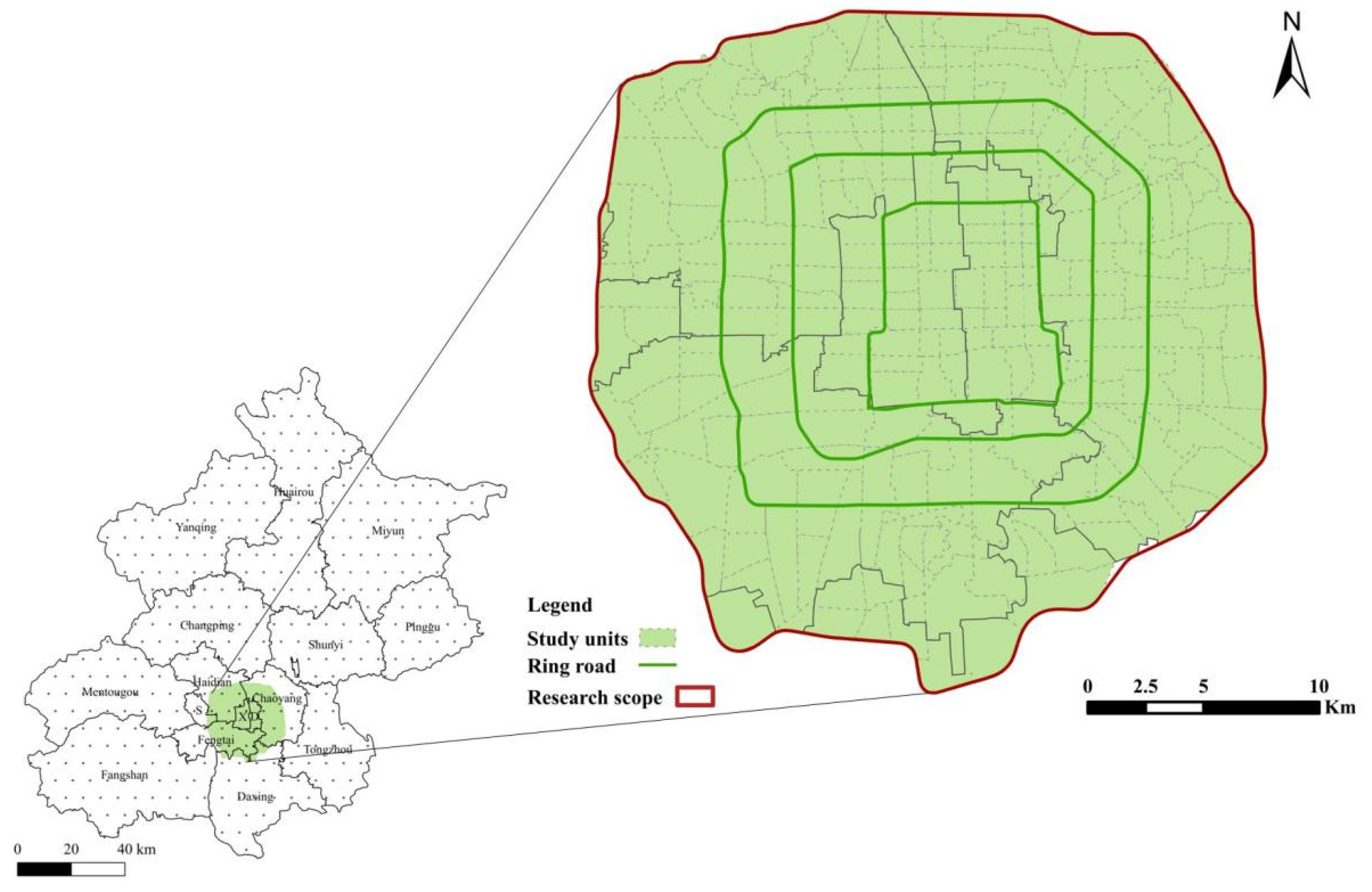
Figure 1. The scope of study area and the study unit.
Sustainability 14 02310 g001
Figure 2. Shopping stores within the Fifth Ring Road of Beijing.
Sustainability 14 02310 g002
Figure 3. Spatial distribution of public transport stations.
Sustainability 14 02310 g003
Figure 4. Cluster level distribution divided by Natural Breaks (Jenks).
Sustainability 14 02310 g004
Figure 5. Several conceptual maps: D is the demand point, circle (1) (2) (3) represent three different inclusion cases for clusters within the travel threshold range. (a) Note the cluster can be reached but not to the center within the travel threshold range; (b) Note the center can be reached but not fully covered; (c) Note a certain cluster can be completely covered.
Sustainability 14 02310 g005
Figure 6. Statistics of travel time under different travel modes of all OD pairs ((a) Driving mode; (b) Public transport mode; (c) Walking mode).
Sustainability 14 02310 g006
Figure 7. Statistics of the shortest travel time under different travel modes ((a) Driving mode; (b) Public transport mode; (c) Walking mode).
Sustainability 14 02310 g007
Figure 8. Average travel time in traffic analysis zones by driving and public transportation ((a) Driving mode; (b) Public transport mode).
Sustainability 14 02310 g008
Figure 9. Research units that can reach the cluster within 15 min of walking.
Sustainability 14 02310 g009
Figure 10. The accessibility result of driving mode.
Sustainability 14 02310 g010
Figure 11. The accessibility result of public transport mode.
Sustainability 14 02310 g011
Figure 12. The accessibility result of walking mode.
Sustainability 14 02310 g012
Figure 13. Results of spatial autocorrelation analysis [50] (H-H = High-High, L-L = Low-Low, L-H = Low-High, H-L = High-Low, N-S = No significant) ((a) Driving mode; (b) Public transport mode; (c) Walking mode).
Sustainability 14 02310 g013
Figure 14. The differences of three transport modes under the two methods ((a) Driving mode; (b) Public transport mode; (c) Walking mode).
Sustainability 14 02310 g014
Publisher’s Note: MDPI stays neutral with regard to jurisdictional claims in published maps and institutional affiliations.