1. Introduction
As the world faces and panics about a less frequent but high-impact new disaster like contagious disease COVID 19, more frequent disasters like floods are expected to continue with worse intensity, frequency and damages. The average data between 1990–2019 show flood-related disasters increased by 43% in 2020, compared to 30 years ago [
1].
Numerous reports focus on flood damages in Thailand [
2]. The 2011 floods were the worst flood event in at least the past five decades. They occurred between late July and early December across nearly every corner of the country. The World Bank estimates THB1.4 trillion (USD45.7 billion) economic losses, more than 884 people were killed, and 65 of Thailand’s 77 provinces were impacted [
3]. In November 2021, 15 Provinces of Thailand were flooding. Flooding is becoming a source of catastrophic disaster for the cities in Thailand, and there is a need for good management. Hence, flood risk reduction (FRR) applications for spatial planning (SP) and urban development need fresh thinking and consideration.
From the growing trend of disaster management, mainstreaming FRR into SP can provide a crucial tool to make management practices economically efficient, environmentally friendly, and sustainable [
4]. Urban flooding increases property losses exponentially. The risk of flooding is directly related to population density and depends on land use patterns in SP [
5]. Moreover, as land-use changes contribute to 21.3% – 35.8% of runoff changes [
6], more attention to runoff in the decision-making for land development may bring less risk. From a practitioner’s point of view, SP is a potential method for flood-risk management. It could fulfill a versatile role in reducing the chances of a flood, preventing urban developments in high-risk flood-prone areas, or planning some transformative SP.
The literature shows that many practical obstacles impede mainstreaming FRR into the spatial plan. Howe and White (2004) found that optimization of flood risk management by SP in the UK is limited by lack of integration between sectors and inadequate coordination [
7]. Further studies on Flood risk management in Dutch local SP practices, conducted by Neuvel and Brink (2009), suggest that some studies show why local planning officials do or do not use SP in advance to reduce flood risk. Moreover, in The Netherlands, a flood mitigation measure of SP is rarely considered, particularly adaptation and recovery from flood hazards. Most cases refer to requirements from other government agencies and local planning agencies’ perceived roles and responsibilities, previous disaster experiences, and previous experiences with SP [
8]. Quesada-román et al., (2020) said that historical natural disasters and public policies to urban sprawl in the Greater Metropolitan Areas are critical for land use planning and disaster risk reduction decision-makers [
9]. Improving regional flood risk assessment requires high-resolution baseline information on flood-frequency analyses, including hydrogeomorphic reconstructions and systematic discharge measurements [
10,
11], which are rarely found in Thailand. The relevant literature and research reviews show that flood risk management practice for Thailand needs to be improved [
12].
2. Spatial Planning, a Potential Method for Flood-Resilient Cities
Combining hazard risk reduction strategies into planning processes in all relevant sectors is necessary for achieving sustainable development. In response to natural disasters like floods, mainstreaming strategies for disaster risk reduction (DRR) have been widely discussed globally for over a decade. In Hyogo Framework for Action (HFA) 2005–2015, disaster-based development is the foundation for countries and communities to build awareness, adaptation, and resilience to disasters and make them sustainable [
13]. Benson et al., (2007) illustrated that mainstreaming DRR into development means considering and addressing risks emanating from natural hazards in medium-term strategic frameworks and institutional structures in national and sectoral strategies/policies and the design of individual projects in hazard-prone countries [
14]. According to the fifth meeting of the Regional Consultative Committee in the National Disaster Management systems of countries of the Asian region, prioritization and mainstreaming of DRR need to be initiated in the national development planning process as well as in six sectors, namely agriculture, urban planning and infrastructure, education, health, housing, and financial service. Moreover, the urban planning and infrastructure sector is discussed widely in disaster management [
15].
Mainstreaming DRR activities in a general land use planning process pertain to the various initiatives, which aim to build upon existing capabilities to initiate land use planning and integrate risk information. Moreover, this is about the content of the land use plan and implementing tools (e.g., zoning, investments, building regulations) that dictate land use, land management, and building design and development [
16]. In the context of preparing a Disaster Risk Management (DRM) Plan, the land use component of the DRM Plan provides for this mainstreaming framework, and its application results in policies, strategies, and investment programs that help build resilience.
In terms of floods, it can be said that MFRRSP is also the most effective solution. SP is considered an essential tool in reducing flood risk due to the strategic ability to prevent land use in flood-prone areas, regulatory ability to adjust land use in risky areas, and communication among various stakeholders. Since the late 1990s, SP has been instrumental in reducing flood risk [
17]. More than that, in the study of planning policy and flood risk: in the translation of national guidance into local policy, White and Richards (2007) described the power hierarchy in management between SP agencies and flood-risk agencies. They found that SP agencies are given more power than agencies that oversee flood risk regarding land use planning and development control in flood-prone areas [
18].
3. Flood Risk Reduction in Thailand’s Spatial Planning
Since the 2011 floods in Thailand, the Ministry of Finance and World Bank (2012) recommended awareness-raising and lessons sharing events within provinces, communities, institutions, and exchanges of good practices from other countries for the long-term FRR mainstreaming. After that, there has been a continuous development of FRR in Thailand’s urban planning [
19].
In the past, the Department of Public Works, Town & Country Planning (DPT) responded to the entire process of comprehensive planning. After the announcement of decentralization and government downsizing policies in 1953, the consultants have played an essential role in shaping Thailand’s urban and regional policies and plans. In terms of flood management, consulting firms provide specialized expertise. They are responsible for analyzing and proposing flood prevention plans based on all relevant information. However, Ratanawaraha (2010) expresses that hiring external consultants has profound implications for urban and regional planning [
20].
In 2014, the DPT set the working group to improve the integrated planning model to find out how to plan and prepare a new urban plan. The new urban planning concept emphasizes solving the flood problem in two phases. In the short term, it focuses on measures to guide the development, and proposes to increase technical support and financial measures to promote urban development in all aspects in the long run. In both the phases, relevant data to be analyzed are clearly defined, including contour and drainage directions, flood risk areas, open space/green area/catchment area, and surface water source.
In 2017, N. Singkran studied flood risk management in Thailand: shifting from a passive to a progressive paradigm. She examines the 2011 floods in Thailand, emphasizing the Chao Phraya River Basin, and analyzes the existing plans and measures relevant to the flood risk management of the country. It also highlights some deficiencies in current practices and suggests improvements using a strategic flood risk management framework. The results indicate the ineffectiveness of flood risk management in Thailand and the urgent need for improvement. Thailand’s flood risk management paradigm relied mainly on structural measures and emergency responses during a flood event through passive response strategies. In contrast, progressive response emphasizes non-structural measures, such as land-use planning, building controls, regulations, and participatory collaboration among government agencies and stakeholders, e.g., people, public, and private agencies in the affected areas [
21]. The novelty of this study is that it focuses on this aspect more closely in the context of Thailand.
Although SP and flood management have gradually evolved in Thailand, they still fall very short of the needs. Thailand’s SP cannot guarantee resilience against floods. The flood risk management framework is inefficient [
12], has no explicit consideration of climate change into urban flood management measures [
22], and lacks institutional arrangement in integrating land use planning and water management [
20,
22]. The SP and its relation to flood risk management of Thailand are conceptually becoming interrelated. However, it is not operational. For Bangkok and at the country level for Thailand, the relevant literature and research reviews show that the risk management practice for flooding is ineffective and needs improvement. Although the concept of urban planning in Thailand has been changed to give greater importance to flood management, there is no way to assess if it effectively guarantees flood prevention or management.
Thus, in this backdrop, the specific contributions of this study are to fill in the gaps in the literature by conducting (a) rapid assessment of how to improve flood risk management by strengthening FRR mainstreaming (b) how and what to consider in non-structural measures while the spatial plan is recommended for integration with flood risk management because of its environmental friendliness and financial sustainability (c) identification of many practical obstacles in integrating SP into the overall flood management plan (d) to provide a direction for the betterment of practices in Thailand and Bangkok in particular.
The paper is organized as follows: The Materials and Methods is in
Section 4.
Section 5 presents some details about the method followed. The results are in
Section 6, followed by discussions in
Section 7, and concluding remarks in
Section 8.
4. Materials and Methods
Keeping in view this study’s specific goals, it first attempts to identify and evaluate the recent trends in mainstreaming the FRR in Thailand’s land use planning. The methods used in this research are content analysis and in-depth interviews. The data sources, including official documents, laws, standards, and key informants involved in water management and country planning, are analyzed with the codes and keywords from the international MFRRSP guideline. The details are in the following subsections.
4.1. Study Area
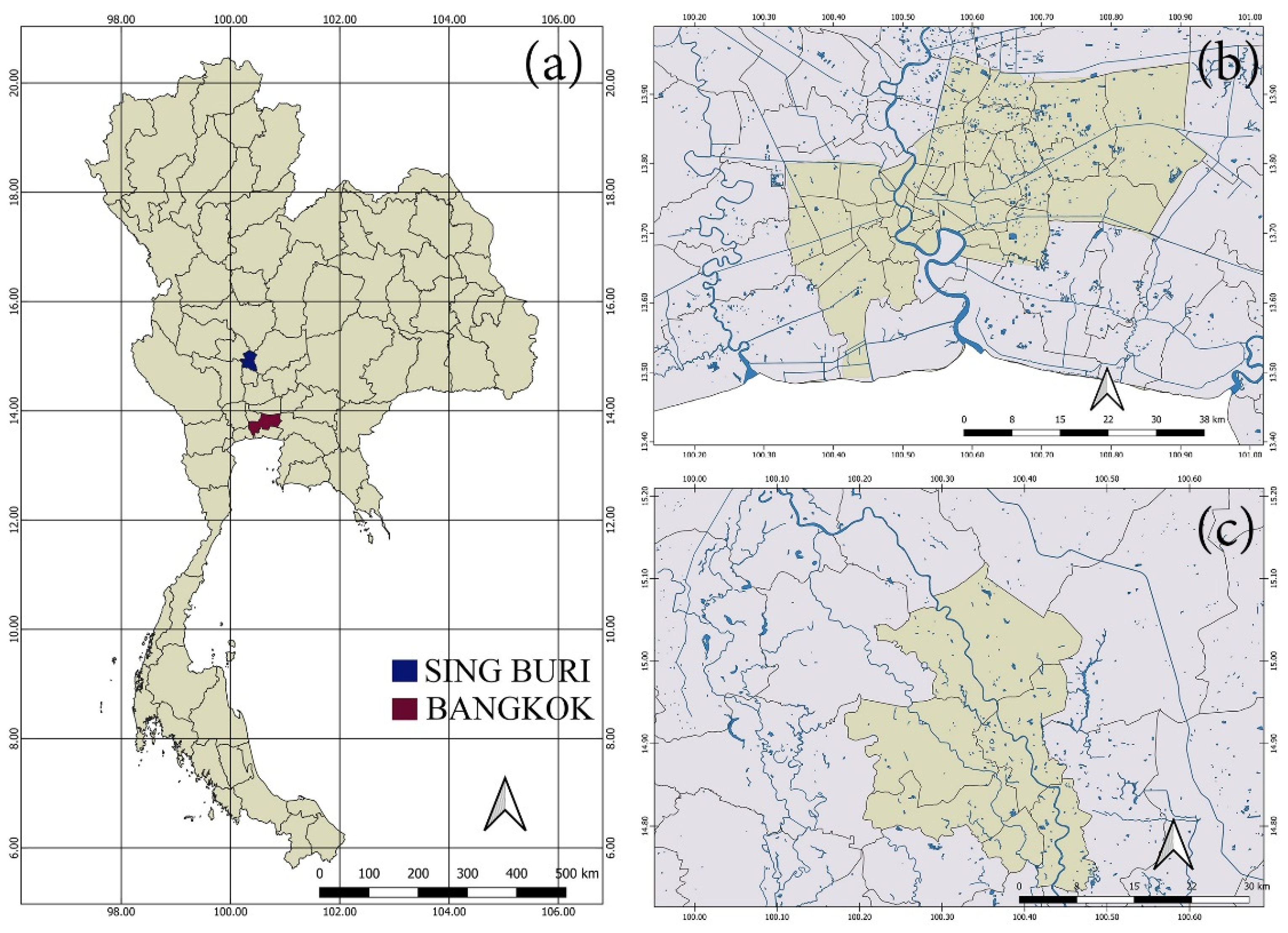
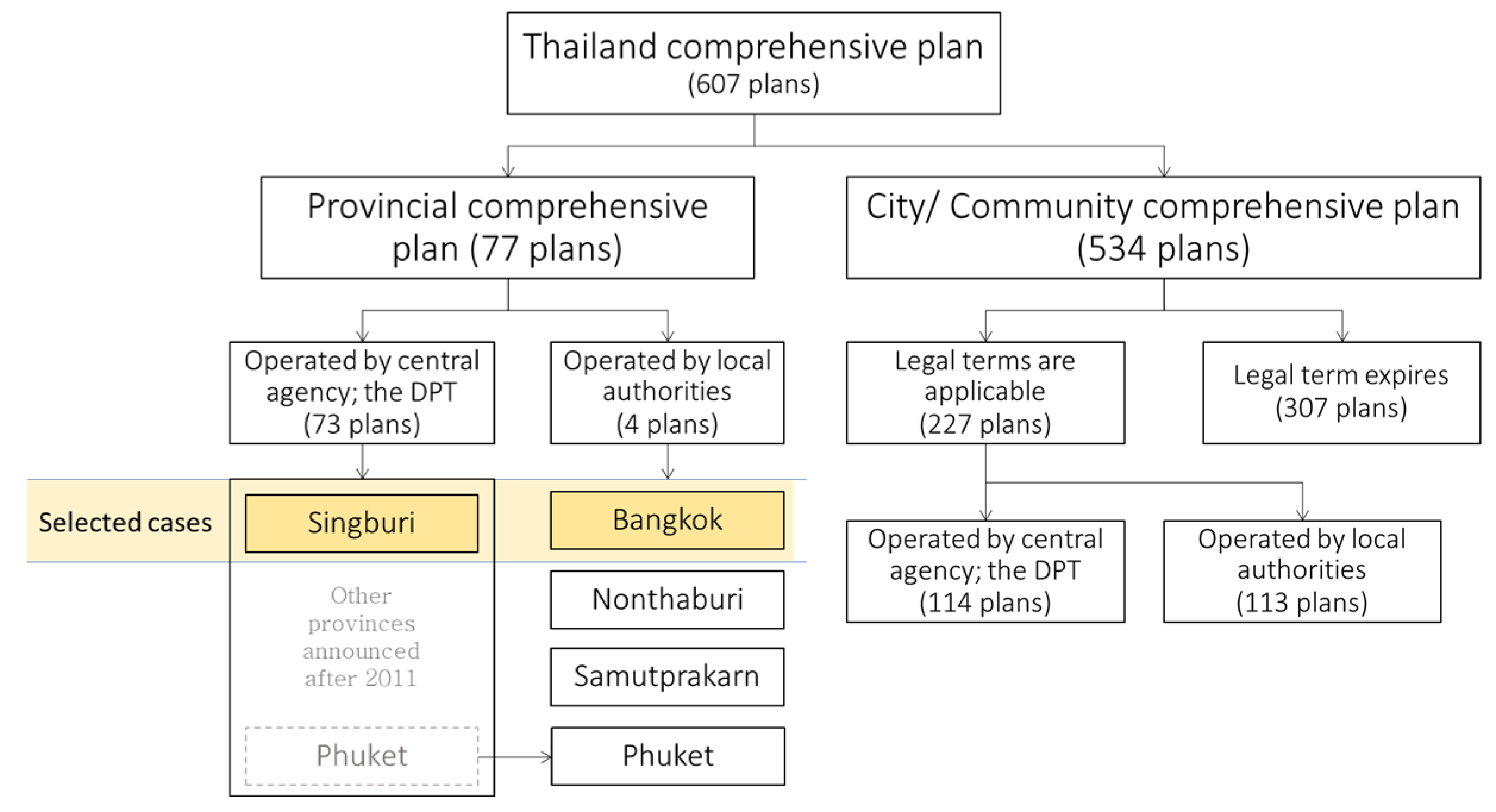
Under the national conceptual plan, law-enforced spatial plans are divided into two significant levels: provincial comprehensive plan and city/community comprehensive plan. Only the provincial level is studied in this paper because it is a complete legal plan covering the entire country, and it is also the plan that clearly shows concern for flood management. Most of Thailand’s provincial urban planning is managed by DPT. Still, four provinces of Thailand, namely Bangkok, Nonthaburi, Samut Prakan, and Phuket, prepare the plan with their local authority under the supervision of DPT. Therefore, the characteristics of provincial comprehensive planning can be divided into two main types: (1) provincial comprehensive plan operated by a central agency, DPT, and (2) provincial comprehensive plan operated by the local authority. Therefore, both types of Thailand’s SP are used as case studies. In addition, this paper presents the changes of FRR in town planning before and after the significant turning points in FM of Thailand. Therefore, the comprehensive planning before and after 2011 of selected cases are also compared. However, some of Thailand’s provincial comprehensive plans were promulgated before 2011 and updated after that. This paper focuses on Bangkok and Sing Buri as case studies (
Figure 1).
Bangkok FRR in SP is under the self-management of the local authority, the Bangkok Metropolitan Administration (BMA). Thailand has organized this style of SP in 4 out of 77 provinces. Bangkok is the capital with the highest population density and economic activity. They have established their own urban planning office providing developments of flood management in urban planning. Bangkok is a flood-prone area located just one meter above sea level. The 2011 floods in mid-October seriously impacted it. Despite the government’s efforts to protect downtown Bangkok, the flooded area was 995.2 square kilometers, i.e., 63.43% of the total area.
Sing Buri is a good case for representing flood management in urban planning managed by DPT. It is located on the floodplain, approximately one hundred kilometers upstream of Bangkok. Sing Buri has a total area of 748.8 square kilometers, or 91.04% of the total area flooded during the 2011 Great Flood. Many attempts came after that to cope with the flood risk in the future. These includes planning activities and flood risk management undertaken by local authorities (
Figure 2).
4.2. Data Sources
The data and information about planning are surveyed and gathered by private consulting companies financed by DPT and by BMA for the case of the Bangkok city plan. However, both cases follow legal planning procedures under the same act. The research materials used for this study are as follows.
(1) The comprehensive land-use plan that was enforced before or during 2011.
(2) The comprehensive land-use plan enforced after 2011 or will be enforced after the next level of changes incorporated.
Regarding the case of Bangkok, the process followed in the preparation of a city plan is analyzed based on the Bangkok Comprehensive Land Use Plan and various study reports. Some were done before 2011, such as the Bangkok Comprehensive Land Use Plan 2013, third revision, and the Bangkok comprehensive plan 2013 done by CPD and Krungthep Thanakom in 2011. Others were done after the flood event of 2011; the draft of the next Bangkok Comprehensive Land Use Plan, the fourth Revision and the study report of the Bangkok comprehensive Plan, the fourth Revision, done by CPD and CHOTICHINDA in 2019. These materials help provide a clear picture of how the SP process is considered in the context of the flood.
A case study in Sing Province, the primary sources of current data are the Sing Buri Comprehensive Land Use Plan 2011, the Sing Buri Comprehensive Land Use Plan (Some additional edits) 2016, the Study report on the Sing Buri Comprehensive Land Use Plan (DPT, 2005), the draft of the Sing Buri Comprehensive Land Use Plan (the upcoming plan), and the study report on the Sing Buri Comprehensive Land Use Plan (PTC, 2017).
4.3. Data and Method of Analysis
Data collection and analysis consist of two main parts: content analysis and interviews. Content analysis is a widely used qualitative research technique. There are three different approaches: common, suggestive, or summary. All three differ in coding schemes, origins of codes, and threats to trustworthiness [
23]. In this study, a summary approach is adopted. It relies on counting and comparing keywords or content followed by a basic contextual interpretation. However, analyzing the document alone may not cover the entire planning process, so in-depth interviews were undertaken to fill this gap.
A qualitative research method, content analysis is a leading tool and provides reliable data analysis for qualitative research. In the first part of this paper, content analysis is done through computer-aided qualitative data analysis software (CAQDS). CAQDS has a vital principle derived from the word “VISE”, an acronym for Visualization, Integration, Serendipity, and Exploration. We review flood resilient SP guidelines and their application to formulate the benchmarking or best practice identification leading to urban resilience through this method. It then examines and evaluates Thailand’s current practices by benchmarking international approaches. ATLAS.ti computer software is applied as a tool for this study. Paulus et al., (2016) argue that ATLAS.ti facilitates work with large datasets and supports more profound levels of analysis than is possible by hand [
24,
25]. Schebesta (2018) explores the value of ATLAS.ti software in conducting content analysis in law and conclude that it is an accessible and valuable tool [
26]. In this paper, the latest version of the software, ATLAS.ti 8, is applied. It is user-friendly and supports a broader range of applications [
27].
The second part of the paper carries out a gap analysis between Thailand’s practice and the international guideline. It will validate the results from the content analysis to explore the insights or detailed reasons for gaps that cannot be obtained from the empirical documentation. Thus, the paper also provides practical recommendations on future flood risk-sensitive land use planning in Thailand by in-depth interview. The relevant individual experts from agencies responsible for the comprehensive planning of DPT, and persons related to water management and SP of Bangkok, The City Planning Division (CPD), were interviewed.
Content analysis through the CAQDS is used for data analysis with the latest software version, ATLAS.ti 8. The mixed research method with a bias towards the qualitative analysis is used here. It consists of two data sources: document review and in-depth interview. An international MFRRSP guideline is created as code for content analysis. The next is coding the selected documents by relevant keywords and contexts.
5. Guidelines, Codes, and Protocols for Contents Analysis
Some practical guidelines for mainstreaming FRR into SP effectively solve the recurrent flooding problems in vulnerable urban areas, but each approach still has some differences. Moreover, the diversity of each area brings in different characteristics which need integration in practice. Therefore, it is necessary to have a standard point of reference that can be universal to understand relative variations in local contexts. Considering the direction of current practices in Thailand, SP can follow international guidelines for comparison in flood management.
In this paper, the guideline covers the mainstreaming FRR into SP based on three international agencies. Firstly, the World Bank and Earthquakes and Megacities Initiative (EMI) published the Risk-Sensitive Land Use Planning Guidebook in 2014, presenting 13 best actions under five assessment areas [
28]. Secondly, UNISDR set 10 actions under four assessment areas shown in 2017 [
29]. Lastly, ADB set four assessment areas with 15 measures presented in 2016 [
30].
After reviewing and analyzing all, we classify them into 22 essential codes as the international benchmarks on MFRRSP, under seven categories of assessment criteria:
Institutional framework and flood risk governance
Flood disaster preparedness
Land use planning process
Investment in FRR
Flood risk information
Stakeholder participation
Land-use tools
The content analysis begins with searching documents by keywords and classifying codes according to the context (
Table 1). After that, all keyword-related terms are defined in that context and words that might be relevant when the document is in Thai. Keywords and contexts are analyzed and assigned to the principles of each code. Therefore, each code is translated into a contextual and related keyword, directed to the realization frequency in the town planning document. Finally, the codes and keywords from MSFRR into spatial planning guidelines were reviewed by three experts specializing in flood and town planning management to find the level of consensus 6.
6. Results
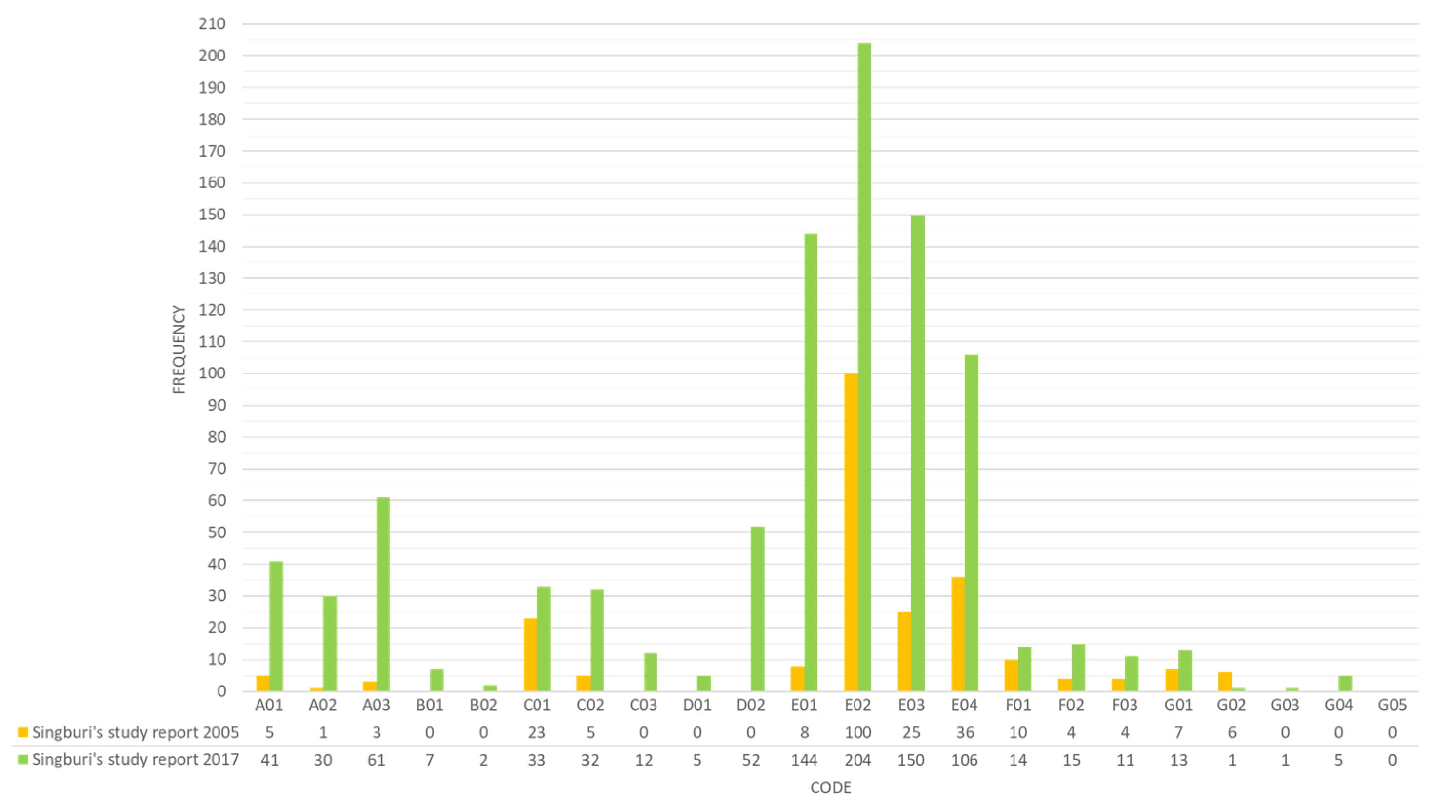
6.1. Sing Buri’s CLUP Case
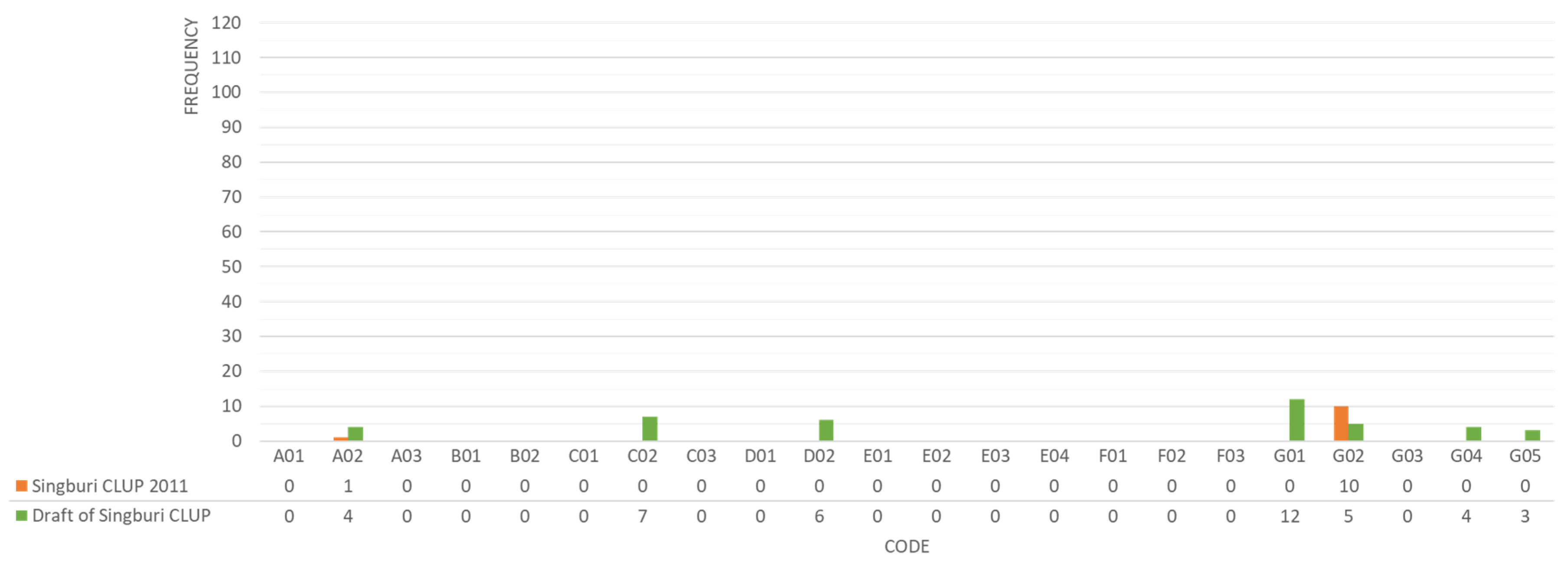
The 2017 Town Planning Report has mentioned the codes A01, A02, and A03, about 14.6-fold of the 2011 city planning report. There was no mention of Assessment B in the 2005 report, but in 2017 there were seven and two references to B01 and B02, respectively. Both reports have the most C01 code in Assessment C. The 2017 report represented 1.4-fold the 2005 report. Simultaneously, the 2005 report mentioned C02 less than 6.4-fold and did not mention C03. Codes D01 and D02 were repeated five and 52 times, respectively, in the 2017 report only. Assessment E was the most frequently cited segment, reaching 71.30% of the 2005 report, 64.32% of the 2017 report, and 2017 representing 3.6 times that of 2005. Assessment E is the most frequently cited segment, reaching 71.30% of the 2005 report, 64.32% of the 2017 report, and 2017 representing 3.6 times that of 2005. Assessment F is mentioned in the 2017 report 2.2 times that of the 2005 report. Finally, Assessment G, Land-use tools, has little practice repetitions in current and old reports. These accounted for 0.05 percent of the 2005 report and 0.02 percent of the 2017 report. Moreover, the G05 code was not shown (
Figure 3).
According to
Figure 4, the regulation documents only mention some codes: A02, C02, D02, G01, G01, G04, and G05. The A02 code was found just once in the 2005 papers, four times in the 2017 CLUP; the C02 code was found seven times in the 2017 CLUP; the D02 code was found six times in the 2017 CLUP. At the same time, Assessment G is most common, up to 4 out of 5 codes, as 90% of the 2005 Legal Requirements and Percentages 58.5 of 2017 CLUP, which is 2.4 times that of 2005.
6.2. Bangkok CLUP Case
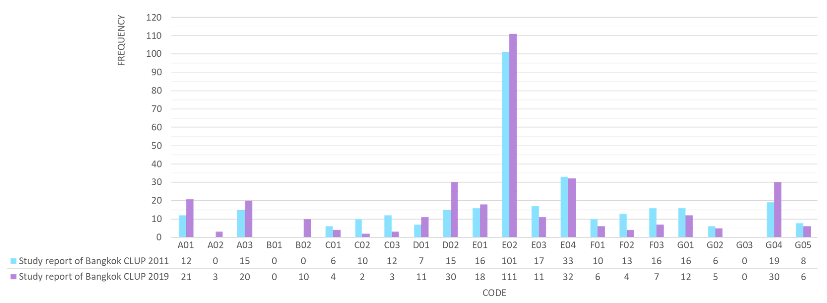
The content analysis of Bangkok’s comprehensive land-use planning report before and after the 2011 floods shows that codes in category A are mentioned 27 and 44 times in the 2005 and 2017 reports, respectively. In the latter, there is duplication of this code 1.63 times. The 2005 report finds no mention of Assessment code B, and there is no mention of code B01 in any of the documents. Assessment category C is different from others. It dropped in the 2017 report from 28 times to nine, or 310%. Assessment category D is mentioned 141% more in the 2017 report. Assessment E in both study reports has a close number of mentions: 167 and 172 times, respectively. Compared to other assessments, 50.3% of the total code number mentioned in the 2005 report and 51.19% of the 2017 report. The mention of Assessment F is reduced by 229%. Assessment G in the 2017 document represents 1.08 times that of 2005, a very close number. Moreover, the G03 code could not be found in any copies (
Figure 5).
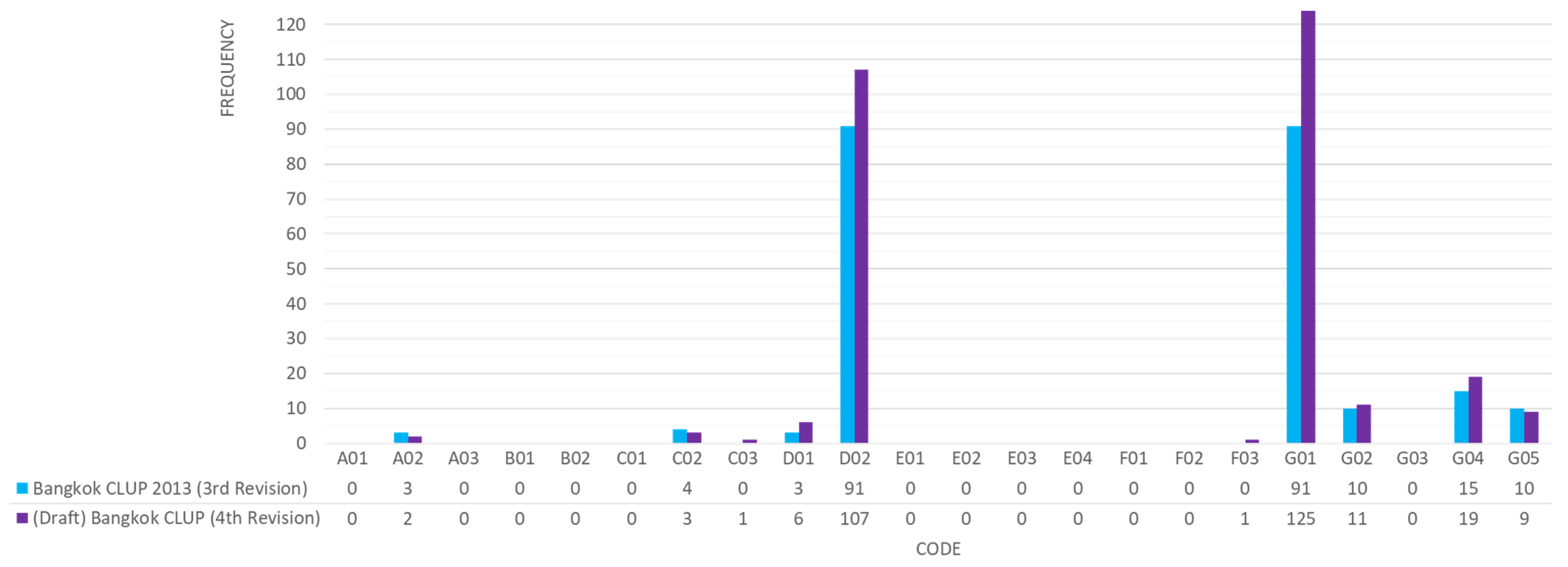
The regulation CLUP shows a tiny percentage of the A02, C02, C03, and F03 codes mentioned, but many iterations of D codes and G codes are mentioned. However, no mention of the G03 code is found, even though Assessment G is more than 50% of the total code count (
Figure 6).
6.3. Thailand MFRRSP Situations
The contents analysis result shows that seven MFRRSP’s assessment categories can summarize Thailand’s existing situation using the international benchmark. Firstly, the FRR in urban planning in the legal and institutional framework for planning is complete in all practices. However, Sing Buri has a higher frequency of mentioning the risk mitigation of floods in the national framework and responsible agencies than Bangkok.
Secondly, comprehensive land-use planning has low reference to flood preparedness actions. In Bangkok, programs and training on FRR are not mentioned. Thirdly, although Bangkok CLUP is low in mentioning FRR as codes are analyzed of different land-use areas, each citation is specific and noticeably clearer in the details of the content. Fourthly, there are many projects and budgets for flood prevention structures, but few incentive measures exist for the homeowners, low-income families, or the private sector to invest in FRR. Fifthly, FHVRA has become a piece of essential information in the urban planning of Thailand. Next, Sing Buri has a higher numbers of stakeholder involvement codes than Bangkok. However, Bangkok has a more specific process to mitigate flood risk. Lastly, open spaces or agricultural areas for flood prevention are the main non-structural measures for Thailand’s FRR in land use policy, planning, construction codes, and standards.
7. Discussions
The content analysis and the confirmation from the interviews and past research studies can be summarized to show trends and challenges in the MFRRSP of Thailand.
7.1. FRR in Thailand’s SP: Changing Phases
From the evidence analyzed based on the SP content of the case study sites, it appears that FRR mainstreaming process started significantly in Thailand only after the 2011 flood. Only three provinces: Bangkok, Sing Buri, and Phuket, had provincial CLUP promulgated before 2011. It is found that although flood management as part of city planning has always been a routine consideration, there is no clear and strict practical guideline. The past town plans emphasize existing water management rather than flood mitigation planning. As per the present data, 73 out of 77 provincial city plans have been announced. It is found that there is more mention of FRR principles in comprehensive land-use planning. Both case studies cited an average 157% greater reduction in flood risk than in the pre-2011 period plans (
Figure 7). In addition, all interviewees had shown consensus in reporting that the great 2011 flood-impacted their work structure. Currently, there are institutional arrangements that designate units responsible for flood management working in urban planning t at all levels. Agencies in water and disaster management need to be more involved in urban planning.
The study results are consistent with Singkran and Kandasamy’s (2017) study on Flood risk management in Thailand. They said that the country’s flood management relies mainly on structural measures and emergency responses which was not an exception during the 2011 floods. Effective programs need to emphasize land use planning, building and development controls, and regulations [
21]. Chitradon, Boonya-aroonnet, and Thanapakpawin (2009) present a risk management framework for the sustainable development of water resources based on flood and drought risks and climate change. They state that regional and sub-regional spatial strategies can be identified to ensure that the risks do not increase to prevent redundant investments [
31].
In addition, the MFRRSP on the part of implementing the BMA’s legal regulations is more apparent than those managed by the DPT. The following draft CLUP of Bangkok presents 217 FRR requirements, while in Sing Buri, only 44, which means the former is 4.93 times more. Khunwishit, Choosuk, and Webb (2018) underscore Thailand’s local government’s role in contributing to disaster risk reduction. The regression analysis revealed that local government leadership is statistically significant in disaster resilience with a positive effect on the progress of flood resilience building [
32]. In the same way, Marks and Lebel (2016) examine the decentralization of reforms and the associated power relations between government agencies at different levels that affected disaster risk outcomes during the 2011 floods in Thailand. The central government monopolized the power and performed poorly than BMA [
33].
7.2. Assessment of Weaknesses of Thailand’s MFRRSP and Recommendations for Strengthening Based on International Comparison
The international principle of MFRRSP guides the FRR in Thailand’s CLUP, but disaster preparedness and stakeholder participation deserve more attention. The FRR preparedness code shows 10 out of 407 in Bangkok’s future Land Use Planning Document and 9 out of 688 in Sing Buri. At the same time, the stakeholder participation code shows 18 out of 407 in Bangkok’s documents and 40 out of 688 in Sing Buri’s documents. There are only 0.011% and 0.035% mentions, respectively.
Bangkok and Sing Buri’s future comprehensive land-use planning has little reference to the flood preparedness actions. Sing Buri has invested in a water surveillance and warning network project. However, there is limited mention of the improvement of the water data system, forecasting, and warning systems in the country’s water management, such as (1) a water meter alarm construction in important rivers (2) CCTV systems installation at flood gates and various pumping stations, (3) optimizing satellite and remote monitoring systems for monitoring the country’s water situation, (4) organization and development of early warning system, etc. In contrast, Bangkok only mentioned early warning systems highly developed in the area. A flood prevention control center has been established to control the flood prevention system and collect various information. Education programs and training on FRR are not mentioned at all.
Although a flood risk map is confirmed as a valuable spatial tool in flood preparedness that should be developed, Thailand does not yet have this risk map. García-Soriano et al., (2020) also determined that a practical method of mapping geomorphological hazards is a useful tool for assessing disaster risk and expanding zoning at a detailed level to assist decision-makers in densely populated urban areas [
34]. It is the base for land use, landscape, and disaster risk planning [
35]. Luu et al., (2020) developed a flood risk assessment framework of the Quang Binh province. Vietnam is widely affected by floods and lacks the same methods and framework for flood risk assessment as Thailand. Vietnam’s government uses historical flood mark data and a high-resolution digital elevation model to create an inundation map, then combines with exposure and vulnerability data to develop a holistic flood risk assessment map [
36]. While there are many studies about flood risk areas of Thailand [
37,
38,
39,
40], no official flood risk map for the whole country is announced in conjunction with the comprehensive land-use plan. Regional and international comparison shows there is a need for a flood preparedness tool for Thailand which is context-specific. Various country-specific studies-Buchori et al. 2018 for Indonesia [
41], A Baky et al. 2019 [
42], Adnan et al. 2019 for Bangladesh [
43], Ziarh et al. 2019 for Malaysia [
44], Li et al. 2020 for Ghent city [
45], Tellman et al. [
46] show how a variety of context-specific spatial planning tool has been used to prepare flood risk reduction preparedness.
Although stakeholder participation has a clearly defined plan and process to understand the flood problem, there is no provision for expert participation in deciding possible causes and solutions through public hearings. The public hearing process thus lacks various solutions to problems. Although those affected were heard and the flood problem is identified, limited discussions are there on the solutions. The participation of experts in water management from relevant agencies such as the Royal Irrigation Department to attend the public hearing can help educate people to think through solutions. Although the public is aware of the flood problem that needs a solution, finding diverse solutions by the non-expert public without expert knowledge. People are familiar with and only think about protecting a particular area by building a flood barrier in their residence, but that might be creating problems elsewhere, so a larger systemic approach of the problem -cause-solution gets ignored. Therefore, if experts participate and explain the advantages and disadvantages of each solution, it will create more knowledge, understanding, and acceptance among the people. The interviewees from the Royal Irrigation Department agreed on this need for a systemic approach and expert engagement in public consultation.
This lack of engagement of experts appears to be the main problem in flood management in many countries. Ciampa et al., (2021) found that although flood mitigation in Mediterranean coastal regions should be performed closely with stakeholders, current involvement at the level of coordination or decision-making does not allow the full integration of local knowledge into flood mitigation projects [
47]. Weng Chan (2012) also said that participation is required, especially from non-governmental organizations (NGOs) at all levels in the disaster cycle [
48]. It is consistent with the in-depth interview results that Thailand requires the involvement of experts to propose solutions going beyond the structural solutions. Compared to flood disaster management in Malaysia, a Southeast Asian country experiencing repeated floods, there is also a need for more significant stakeholders’ participation [
49].
7.3. Limitations in Implementation
This paper found that open spaces or agricultural areas for flood prevention, G01code, are the main non-structural measures for Thailand’s FRR. The G code represents FRR implementation through regulations, incentives, infrastructure, emergency area designations, building codes, and density restrictions.
Figure 7 shows that G01 is the most frequently used code. This code is repeated 137 times in documents relating to Bangkok. For Sing Buri, agricultural land is used for flood prevention and open space for flood protection, divided into temporary high-flooded open areas along the riverbanks to maintain natural drainage capacity, mentioned 25 times. In contrast, two implementation problems are identified. There are no emergency management spatial requirements; rather, there is a tendency to reduce conservation areas for flood prevention.
Firstly, there is a lack of spatial planning methods for flood emergencies. There is a need to introduce this at the project and town planning levels through building code and land use plan. Code G03, related to emergency management that is dealt with using land-use methods such as assembly point, a safe area, and shelter, does not appear in any CLUP for Bangkok. Only one flood-safe place has been identified in Sing Buri for urgent evacuation. Kumar et al., (2021) show the losses due to disasters in a residential property in Mumbai could be minimized by mainstreaming emergency management requirements into the design tenets. Spatial tools used in the project include assembly points for emergencies and a natural drainage network within a km—radius from the project site [
50]. Luther et al., (2012) illustrate that the content of the risk maps often does not meet the end user’s needs. Therefore, emergency management information on existing or planned defenses, evacuation routes, and assembly points in flood risk maps should be mainstreamed into a management framework [
51].
Secondly, there is a tendency to reduce through development plans in the area preserved to prevent flood risks. This trend is evident in the upcoming CLUP of Bangkok. The number of G01 and G05 codes in the future CLUP is reduced from the current version. The open space for the conservation of natural drainage is reduced by approximately 181.96 sq km or 113,722.27 rai (equivalent local measurement unit). Floodways in the upper west side of Bangkok, such as Taling Chan, Phasi Charoen, and Bang Khae districts, have been modified to commercial, moderately dense, and low-density housing areas to support the development of suburban centers.
However, documents show a tendency to think that reduced preserved areas for flood protection will be guaranteed/replaced by optimizing the structure measure. Many investments have been in flood protection structures in the next Bangkok CLUP (107 times mentioned). While the investment in structural measures to prevent flooding and drainage in Sing Buri is less than in Bangkok, it is higher than the non-structured measures. Interview with flood management experts also shows that experts feel this idea remains questionable because it is challenging to evaluate the effectiveness of structural and non-structural measures comparatively. In the case of Dhaka city, Faisal et al., (1999) indicated that non-structural measures play an essential role in reducing flood damage and are proposed as part of a long-term flood mitigation strategy [
52]. Sun et al., (2012) systematically illustrate the main contents of the National Flash Flood Control Planning in 2006, where non-structural measures are recommended to prevent flash floods [
53].
Petry (2002) presents a balance between structural and non-structural measures to manage the flood. The acceptance of flooding conditions and fast return to normality is unavoidable in flood-exposed regions—the concept of flood risk management should not only depend on structural measures. Still, it should also consider non-structural measures [
54]. According to an economic evaluation of structural and non-structural flood risk management measures, examples from the Mulde River, Meyer et al., (2012) demonstrate that effectiveness and cost-effectiveness cannot consider all kinds of costs and benefits. Nonetheless, non-structural measures alone cannot be followed in full due to the market value of structural development. Some effects are not easily measurable in monetary terms [
55]. Therefore, it is very difficult for decision-makers and needs a different approach for awareness generation in local conditions through education and involvement of experts and academic institutions to find practical, workable solutions.
8. Conclusions and Recommendations
The 2011 great flood of Thailand could dramatically change the pattern of flood management in the country. International organizations recognize that integrating FRR into urban planning is the most effective tool to formulate guidelines for the implementation of flood management. For identifying the best practices of FRR in urban planning in Thailand, this study assesses the spatial planning documents related to flood management. It compares with international guidelines, which helps advance knowledge in the field to understand what makes local contexts vulnerable. The study areas are Bangkok, and Sing Buri, representing two different urban planning styles in Thailand and the areas experiencing recurring flood events.
Based on content analysis through CAQDS and in-depth interviews with experts, it appears FRR in Thailand needs appropriate efforts to be mainstreamed into spatial land-use planning following international requirements and principles in all areas. Both the case study sites show a change in official documents on an average 157% reduction potential in flood risk compared to the pre-2011 plans. However, it still has gaps in the implementation. First, there are few flood preparedness actions. The FRR preparedness code shows only 0.011% mention in all assessed documents. Next, the current stakeholder participation process in flood management is inadequate and lacks expert knowledge based on opinions towards solution planning and design as there is only 0.035% mentioned. Participants in public consultation are usually the affected groups who can identify problems but cannot provide solutions.
From the official documents, it appears that the future flood risk management in urban planning tends to rely on investment in flood protection structures, reduction in the conservation area for flood protection, and making more use of that land for urbanization. Thus, there are still arguments between conservationists and developers in land use planning.
Strengthening flood preparedness and stakeholder participation is the priority that should be considered for Thailand flood risk reduction in spatial management. As for flood disaster preparedness, a flood risk map is an essential tool available for city planners. As for stakeholder participation in every step of the town planning process, expert consultation from relevant agencies and academic institutions is necessary, especially in water management. Experts and NGOs should attend the public hearing to educate people on solving problems in the area.
Further studies should be done to compare the pros and cons of flood risk management for to decide on actions for future flood risk reduction. This study has focused more on top-down decision-makers’ perspective. The people on the ground enforcing the rules and regulations and beneficiaries’ perspectives to achieve the goal of integrating FRR into SP and urban planning need equal importance. Therefore, this research opens the possibility of bottom-up study. In addition, there is need for understanding consistency and preparation of a detailed workplan for integrating the processes for urban planning practices in Thailand, flood risk management and the 20-year National Water Management Master Plan (2018–2037).
Author Contributions
Conceptualization, A.C. and S.M.K.; methodology, A.C.; software, A.C.; validation, S.M.K., V.N., I.P. and J.R.; formal analysis, A.C.; investigation, S.M.K., V.N., I.P. and J.R.; resources, T.R.; data curation, A.C.; writing—original draft preparation, A.C.; writing—review and editing S.M.K., V.N., I.P., J.R. and T.R.; visualization, A.C.; supervision, S.M.K., V.N.; project administration, A.C.; funding acquisition, A.C. All authors have read and agreed to the published version of the manuscript.
Funding
This research was funded by the Royal Thai Government (RTG) Fellowships 2015 and the Asian Institute of Technology (AIT) scholarship scheme.
Institutional Review Board Statement
Not applicable.
Informed Consent Statement
Not applicable.
Data Availability Statement
Data sharing not applicable.
Acknowledgments
We want to thank the following organization, DPT, BMA, ONWR, RID, DDPM, RD, and Sing Buri Province VNRE, for the data support. We also would like to thank all the experts from many educational institutions and consulting firms.
Conflicts of Interest
The authors declare no conflict of interest.
References
- Global Natural Disaster Assessment Report. 2020. Available online: https://reliefweb.int/sites/reliefweb.int/files/resources/2020%20Global%20Natural%20Disaster%20Assessment%20Report-EN%282%29.pdf (accessed on 24 November 2021).
- Thailand Country Report. 2020. Available online: https://www.adrc.asia/countryreport/THA/2020/THA_CR2020.pdf (accessed on 24 November 2021).
- Aon Benfield. 2011 Thailand Floods Event Recap Report; Aon Corporation: Chicago, IL, USA, 2012. [Google Scholar]
- Dawson, R.J.; Ball, T.; Werritty, J.; Werritty, A.; Hall, J.W.; Roche, N. Assessing the effectiveness of non-structural flood management measures in the Thames Estuary under conditions of socio-economic and environmental change. Glob. Environ. Change 2011, 21, 628–646. [Google Scholar] [CrossRef]
- Lee, Y.; Brody, S.D. Examining the impact of land use on flood losses in Seoul, Korea. Land Use Policy 2018, 70, 500–509. [Google Scholar] [CrossRef]
- Li, B.; Shi, X.; Lian, L.; Chen, Y.; Chen, Z.; Sun, X. Quantifying the effects of climate variability, direct and indirect land use change, and human activities on runoff. J. Hydrol. 2020, 584, 124684. [Google Scholar] [CrossRef]
- Howe, J.; White, I. Like a fish out of water: The relationship between planning and flood risk management in the UK. Plan. Pract. Res. 2004, 19, 415–425. [Google Scholar] [CrossRef]
- Neuvel, J.M.M.; Brink, A.V.D. Flood risk management in dutch local spatial planning practices. J. Environ. Plan. Manag. 2009, 52, 865–880. [Google Scholar] [CrossRef]
- Quesada-Román, A.; Villalobos-Portilla, E.; Campos-Durán, D. Hydrometeorological disasters in urban areas of Costa Rica, Central America. Environ. Hazards 2021, 20, 264–278. [Google Scholar] [CrossRef]
- Quesada-Román, A.; Ballesteros-Cánovas, J.A.; Granados-Bolaños, S.; Birkel, C.; Stoffel, M. Improving regional flood risk assessment using flood frequency and dendrogeomorphic analyses in mountain catchments impacted by tropical cyclones. Geomorphology 2022, 396, 108000. [Google Scholar] [CrossRef]
- Quesada-Román, A.; Villalobos-Chacón, A. Flash flood impacts of Hurricane Otto and hydrometeorological risk mapping in Costa Rica. Geogr. Tidsskr.-Dan. J. Geogr. 2020, 120, 142–155. [Google Scholar] [CrossRef]
- Singkran, N.; Kandasamy, J. Developing a strategic flood risk management framework for Bangkok, Thailand. Nat. Hazards 2016, 84, 933–957. [Google Scholar] [CrossRef]
- United Nations. Hyogo Framework for Action 2005–2015: Building the Resilience of Nations and Communities to Disasters. In Proceedings of the World Conference on Disaster Reduction, Hyogo, Japan, 18–22 January 2005. [Google Scholar]
- Benson, C.; Twigg, J. Tools for Mainstreaming Disaster Risk Reduction: Guidance Notes for Development Organisations; The ProVention Consortium: Geneva, Switzerland, 2007. [Google Scholar]
- Yodmani, S. 5th Meeting of the ADPC Regional Consultative Committee on Disaster Management. In Proceedings of the Asia to the UN World Conference on Disaster Reduction (WCDR) 2005, Hanoi, Vietnam, 18–20 May 2005. [Google Scholar]
- March, B.; Benson, C.; Twigg, J. Mainstreaming Disaster Risk Reduction into Development: Challenges and Experience the Philippines Tools for Mainstreaming in Disaster Risk; The ProVention Consortium: Geneva, Switzerland, 2009. [Google Scholar]
- Restemeyer, B.; Brink, M.V.D.; Woltjer, J. Decentralized Implementation of Flood Resilience Measures—A Blessing or a Curse? Lessons from the Thames Estuary 2100 Plan and the Royal Docks Regeneration. Plan. Pract. Res. 2019, 34, 62–83. [Google Scholar] [CrossRef] [Green Version]
- White, I.; Richards, J. Planning policy and flood risk: The translation of national guidance into local policy. Plan. Pract. Res. 2007, 22, 513–534. [Google Scholar] [CrossRef]
- Thailand Flooding 2554 Rapid Assessment for Resilient Recovery and Reconstruction Planning. Available online: https://www.undp.org/content/dam/thailand/docs/UNDP_RRR_THFloods.pdf (accessed on 12 January 2021).
- Ratanawaraha, A. Institutional Issues in Integrating Land Use Planning and Water Management in Thailand; TDRI: Bangkok, Thailand, 2016. [Google Scholar]
- Singkran, N. Flood risk management in Thailand: Shifting from a passive to a progressive paradigm. Int. J. Disaster Risk Reduct. 2017, 25, 92–100. [Google Scholar] [CrossRef]
- Saito, N. Challenges for adapting Bangkok’s flood management systems to climate change. Urban Clim. 2014, 9, 89–100. [Google Scholar] [CrossRef]
- Hsieh, H.F.; Shannon, S.E. Three approaches to qualitative content analysis. Qual. Health Res. 2005, 15, 1277–1288. [Google Scholar] [CrossRef] [PubMed]
- Paulus, T.M.; Lester, J.N. ATLAS.ti for conversation and discourse analysis studies. Int. J. Soc. Res. Methodol. 2016, 19, 405–428. [Google Scholar] [CrossRef]
- Paulus, T.M.; Pope, E.M.; Woolf, N.; Silver, C. It will be very helpful once I understand ATLAS.ti: Teaching ATLAS.ti using the Five-Level QDA method. Int. J. Soc. Res. Methodol. 2019, 22, 1–18. [Google Scholar] [CrossRef]
- Schebesta, H. Content analysis software in legal research: A proof of concept using ATLAS.ti. Tilburg Law Rev. 2018, 23, 23–33. [Google Scholar] [CrossRef]
- Susanne, F. ATLAS.ti 8 Windows; ATLAS.ti Scientific Software Development GmbH: Berlin, Germany, 2017. [Google Scholar]
- World Bank; EMI. Risk-Sensitive Land Use Planning Guidebook: Bangladesh Urban Earthquake Resilience Project; Earthquakes and Megacities Initiative: Manila, Philippines, 2014. [Google Scholar]
- UNISDR. Implementation Guide for Local Authorities, Words into Action Guidelines, a Companion for Implementing Sendai Framework Priority 4; United Nations Office for Disaster Risk Reduction: Geneva, Switzerland, 2017. [Google Scholar]
- ADB. Reducing Disaster Risk by Managing Urban Land Use: Guidance Notes for Planners; Asian Development Bank: Mandaluyong City, PH, USA, 2016. [Google Scholar]
- Chitradol, R.; Boonya-aroonnet, S.; Thanapakpawin, P. Risk Management of Water Resources in Thailand in the Face of Climate Change. Sasin J. Manag. 2009, 15, 64–73. [Google Scholar]
- Khunwishit, S.; Choosuk, C.; Webb, G. Flood Resilience Building in Thailand: Assessing Progress and the Effect of Leadership. Int. J. Disaster Risk Sci. 2018, 9, 44–54. [Google Scholar] [CrossRef] [Green Version]
- Marks, D.; Lebel, L. Disaster governance and the scalar politics of incomplete decentralization: Fragmented and contested responses to the 2011 floods in Central Thailand. Habitat Int. 2016, 52, 57–66. [Google Scholar] [CrossRef]
- García-Soriano, D.; Quesada-Román, A.; Zamorano-Orozco, J.J. Geomorphological hazards susceptibility in high-density urban areas: A case study of Mexico City. J. S. Am. Earth Sci. 2020, 102, 102667. [Google Scholar] [CrossRef]
- Quesada-Román, A.; Castro-Chacón, J.P.; Feoli-Boraschi, S. Geomorphology, land use, and environmental impacts in a densely populated urban catchment of Costa Rica. J. S. Am. Earth Sci. 2021, 112, 103560. [Google Scholar] [CrossRef]
- Luu, C.; Tran, H.X.; Pham, B.T.; Al-Ansari, N.; Tran, T.Q.; Duong, N.Q.; Dao, N.H.; Nguyen, L.P.; Nguyen, H.D.; Ta, H.T.; et al. Framework of spatial flood risk assessment for a case study in Quang Binh province, Vietnam. Sustainability 2020, 12, 3058. [Google Scholar] [CrossRef] [Green Version]
- Duan, M.; Zhang, J.; Liu, Z.; Aekakkararungroj, A. Use of remote sensing and GIS for flood hazard mapping in Chiang Mai Province, northern Thailand. In Proceedings of the International Conference on Geo-spatial Solutions for Emergency Management and the 50th Anniversary of the Chinese Academy of Surveying and Mapping, Beijing, China, 14–16 September 2009; pp. 203–208. [Google Scholar]
- Vojinovic, Z.; Hammond, M.J.; Golub, D.; Hirunsalee, S.; Weesakul, S.; Meesuk, V.; Medina, N.; Sanchez, A.; Kumara, S.; Abbott, M. Holistic approach to flood risk assessment in areas with cultural heritage: A practical application in Ayutthaya, Thailand. Nat. Hazards 2016, 81, 589–616. [Google Scholar] [CrossRef] [Green Version]
- Arunyanart, N.; Limsiri, C.; Uchaipichat, A. Flood hazards in the chi river basin, Thailand: Impact management of climate change. Appl. Ecol. Environ. Res. 2017, 15, 841–861. [Google Scholar] [CrossRef]
- Seejata, K.; Yodying, A.; Wongthadam, T.; Mahavik, N.; Tantanee, S. Assessment of flood hazard areas using Analytical Hierarchy Process over the Lower Yom Basin, Sukhothai Province. Procedia Eng. 2018, 212, 340–347. [Google Scholar] [CrossRef]
- Buchori, I.; Sugiria, A.; Mussaduna, M.; Wadleyb, D.; Liub, Y.; Pramitasaric, A.; Pamungkas, I.T.D. A predictive model to assess spatial planning in addressing hydro-meteorological hazards: A case study of Semarang City. Indonesia. Int. J. Disaster Risk Reduct. 2018, 27, 415–426. [Google Scholar] [CrossRef]
- Baky, M.; Islam, M.; Paul, S. Flood Hazard, Vulnerability and Risk Assessment for Different Land Use Classes Using a Flow Model. Earth Syst. Environ. 2020, 4, 225–244. [Google Scholar] [CrossRef] [Green Version]
- Adnan, M.S.G.; Dewan, A.; Zannat, K.E.; Abdullah, A.Y.M. The use of watershed geomorphic data in flash flood susceptibility zoning: A case study of the Karnaphuli and Sangu river basins of Bangladesh. Nat. Hazards 2019, 99, 425–448. [Google Scholar] [CrossRef]
- Ziarh, G.F.; Asaduzzaman, M.; Dewan, A.; Nashwan, M.S.; Shahid, S. Integration of catastrophe and entropy theories for flood risk mapping in peninsular Malaysia. J. Flood Risk Manag. 2021, 14, 12686. [Google Scholar] [CrossRef]
- Li, L.; Uyttenhove, P.; Eetvelde, V. Planning green infrastructure to mitigate urban surface water flooding risk—A methodology to identify priority areas applied in the city of Ghent. Landsc. Urban Plan. 2020, 194, 103703. [Google Scholar] [CrossRef]
- Tellman, B.; Sullivan, J.A.; Kuhn, C.; Kettner, A.J.; Doyle, C.S.; Brakenridge, G.R.; Erickson, T.; Slayback, D.A. Satellite imaging reveals increased proportion of population exposed to floods. Nature 2021, 596, 7870. [Google Scholar] [CrossRef] [PubMed]
- Ciampa, F.; Seifollahi-Aghmiuni, S.; Kalantari, Z.; Ferreira, C.S.S. Flood mitigation in Mediterranean coastal regions: Problems, solutions, and stakeholder involvement. Sustainability 2021, 13, 10474. [Google Scholar] [CrossRef]
- Chan, N.W. Impacts of Disasters and Disasters Risk Management in Malaysia: The Case of Floods. In Economic and Welfare Impacts of Disasters in East Asia and Policy Responses; ERIA Research Project Report 2011-8; Sawada, Y., Oum, S., Eds.; ERIA: Jakarta, Indonesia, 2012; pp. 503–551. [Google Scholar]
- Chan, N.W.; Azizi, Z.N.; Aminuddin, A.G.; Foo, K.Y.; Lee, L.K. Review and study of current existing Standard Operation Procedures (SOPs) for flood disaster management in Malaysia. J. Teknol. 2015, 72, 1–11. [Google Scholar]
- Kumar, A.; Masane, Y.; Dhakhwa, S. Disaster management plan for residential-cum-commercial property in Mumbai: A case study. Environ. Dev. Sustain. 2021, 23, 12598–12614. [Google Scholar] [CrossRef]
- Luther, J.; Meyer, V.; Kuhlicke, C.; Scheuer, S.; Unnerstall, H. Improving Flood Risk Maps as a Capacity Building Activity: Fostering Public Participation and Raising Flood Risk Awareness in the German Mulde Region (project RISK MAP). In Proceedings of the EGU General Assembly 2012, Vienna, Austria, 22–27 April 2012; p. 12131. [Google Scholar]
- Faisal, I.M.; Kabir, M.R.; Nishat, A. Non-structural flood mitigation measures for Dhaka City. Urban Water 1999, 1, 145–153. [Google Scholar] [CrossRef]
- Sun, D.; Zhang, D.; Cheng, X. Framework of national non-structural measures for flash flood disaster prevention in China. Water 2012, 4, 272–282. [Google Scholar] [CrossRef]
- Petry, B. Keynote lecture: Coping with floods: Complementarity of structural and non-structural measures. In Flood Defence 2002; Wu, B.S., Wang, Z.Y., Wang, G.Q., Huang, G.H., Fang, H.W., Huang, J.C., Eds.; Science Press: New York, NY, USA, 2002; pp. 60–70. [Google Scholar]
- Meyer, V.; Priest, S.; Kuhlicke, C. Economic evaluation of structural and non-structural flood risk management measures: Examples from the Mulde River. Nat. Hazards 2012, 62, 301–324. [Google Scholar] [CrossRef]
| Publisher’s Note: MDPI stays neutral with regard to jurisdictional claims in published maps and institutional affiliations. |
© 2022 by the authors. Licensee MDPI, Basel, Switzerland. This article is an open access article distributed under the terms and conditions of the Creative Commons Attribution (CC BY) license (https://creativecommons.org/licenses/by/4.0/).


 ,
, 


