

Seismotectonics of Shallow-Focus Earthquakes in Venezuela with Links to Gravity Anomalies and Geologic Heterogeneity Mapped by a GMT Scripting Language


Abstract
1. Introduction
1.1. Background and Motivation
1.2. Contemporaneity and Objectives
2. Study Area
3. Methodology
3.1. Data
3.2. Methods
4. Results
5. Conclusions
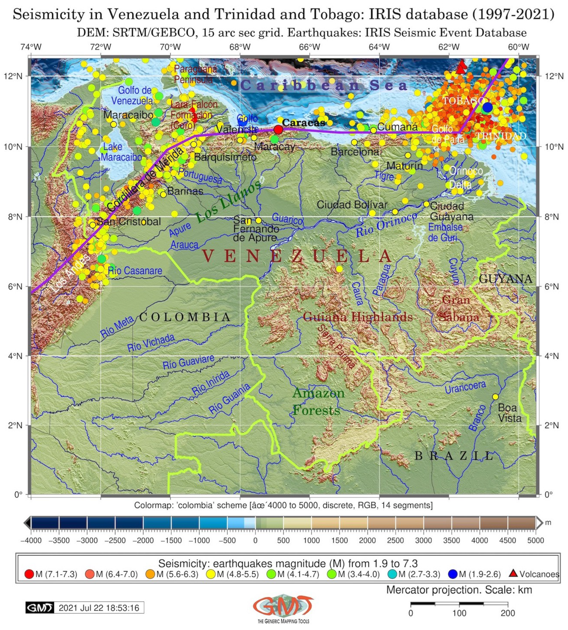
- Region: The region of Venezuela is at high risk of seismicity and earthquakes because it is located in the zone of the collision of the South American and Caribbean tectonic plates and the Andean orogeny. This requires spatial analysis of the regions that are at risk.
- Geohazard: The risk assessment of geophysical hazards was based on the effective integration and visualization of multi-source data, which provided detailed insights into the environmental and geological settings of Venezuela and supported complex investigations in seismically active regions of South America.
- Data: Geological disasters are related to high seismicity, exposure to hazards, and vulnerability of people at risk. This requires complex and detailed studies that summarize these factors and visualize regional geophysical settings, as shown in this paper.
- Methods: The combination of scripting for GMT and GIS is a solid foundation for cartographic data analysis. An efficient method for processing multi-format data ensures hazard mapping and geophysical and geological visualization with the aim of preventing and evaluating seismic hazards.
Author Contributions
Funding
Institutional Review Board Statement
Informed Consent Statement
Data Availability Statement
Acknowledgments
Conflicts of Interest
Abbreviations
| CSV | Comma-separated values |
| DCW | Digital Chart of the World |
| EGM | Earth Gravitational Models |
| GEBCO | General Bathymetric Chart of the Oceans |
| GIS | Geographic Information System |
| GMT | Generic Mapping Tools |
| GUI | Graphical User Interface |
| QGIS | Quantum GIS |
| IRIS | Incorporated Research Institutions for Seismology |
| NetCDF | Network Common Data Form |
| NGDC | National Geophysical Data Center |
| USGS | United States Geological Survey |
Appendix A. GMT Scripts
Appendix A.1. GMT Script for Topographic Mapping
| Listing A1: GMT code used to plot Figure 1 (topographic map). |
  |
Appendix A.2. GMT Script for Geoid Mapping
| Listing A2: GMT code used to plot Figure 4 (geoid modeling). |
  |
Appendix A.3. GMT Script for Free-Air Gravity Mapping
| Listing A3: GMT code used to plot Figure 5 (free-air gravity modeling). |
  |
Appendix A.4. GMT Script for Vertical Gradient of Gravity
| Listing A4: GMT code used to plot Figure 5 (free-air gravity modeling). |
  |
Appendix A.5. GMT Script for Seismic Mapping
| Listing A5: GMT codes used to plot Figure 7 (seismic mapping). |
  |
References
- Laffaille, J.; Ferrer, C.; Laffaille, K. Venezuela: The Construction of Vulnerability and Its Relation to the High Seismic Risk. Dev. Earth Surf. Process. 2009, 13, 99–114. [Google Scholar] [CrossRef]
- Schmitz, M.; Hernández, J.J.; Rocabado, V.; Domínguez, J.; Morales, C.; Valleé, M.; García, K.; Sánchez-Rojas, J.; Singer, A.; Oropeza, J.; et al. The Caracas, Venezuela, Seismic Microzoning Project: Methodology, results, and implementation for seismic risk reduction. Prog. Disaster Sci. 2020, 5, 100060. [Google Scholar] [CrossRef]
- Weber, J.C.; Saleh, J.; Balkaransingh, S.; Dixon, T.; Ambeh, W.; Leong, T.; Rodriguez, A.; Miller, K. Triangulation-to-GPS and GPS-to-GPS geodesy in Trinidad, West Indies: Neotectonics, seismic risk, and geologic implications. Mar. Pet. Geol. 2011, 28, 200–211. [Google Scholar] [CrossRef]
- Khan, A.; Gupta, S.; Gupta, S.K. Multi-hazard disaster studies: Monitoring, detection, recovery, and management, based on emerging technologies and optimal techniques. Int. J. Disaster Risk Reduct. 2020, 47, 101642. [Google Scholar] [CrossRef]
- Mesgar, M.A.A.; Jalilvand, P. Vulnerability Analysis of the Urban Environments to Different Seismic Scenarios: Residential Buildings and Associated Population Distribution Modelling through Integrating Dasymetric Mapping Method and GIS. Procedia Eng. 2017, 198, 454–466. [Google Scholar] [CrossRef]
- Nath, S.K. An initial model of seismic microzonation of Sikkim Himalaya through thematic mapping and GIS integration of geological and strong motion features. J. Asian Earth Sci. 2005, 25, 329–343. [Google Scholar] [CrossRef]
- Kwag, S.; Choi, E.; Hahm, D.; Eem, S.; Ju, B.S. On improving seismic risk and cost for nuclear energy facility based on multiobjective optimization considering seismic correlation. Energy Rep. 2022, 8, 7230–7241. [Google Scholar] [CrossRef]
- Kwag, S.; Choi, E.; Eem, S.; Ha, J.G.; Hahm, D. Toward improvement of sampling-based seismic probabilistic safety assessment method for nuclear facilities using composite distribution and adaptive discretization. Reliab. Eng. Syst. Saf. 2021, 215, 107809. [Google Scholar] [CrossRef]
- Liu, H.; Cui, X.; Yuan, D.; Wang, Z.; Jin, J.; Wang, M. Study of Earthquake Disaster Population Risk Based on GIS A Case Study of Wenchuan Earthquake Region. Procedia Environ. Sci. 2011, 11, 1084–1091, 2011 2nd International Conference on Challenges in Environmental Science and Computer Engineering (CESCE 2011). [Google Scholar] [CrossRef]
- Zheng, X.; Feng, C.; Ishiwatari, M. Examining the Indirect Death Surveillance System of The Great East Japan Earthquake and Tsunami. Int. J. Environ. Res. Public Health 2022, 19, 12351. [Google Scholar] [CrossRef]
- Peng, C.; Jiang, P.; Ma, Q.; Su, J.; Cai, Y.; Zheng, Y. Chinese Nationwide Earthquake Early Warning System and Its Performance in the 2022 Lushan M6.1 Earthquake. Remote Sens. 2022, 14, 4269. [Google Scholar] [CrossRef]
- Adu-Gyamfi, B.; Shaw, R. Risk Awareness and Impediments to Disaster Preparedness of Foreign Residents in the Tokyo Metropolitan Area, Japan. Int. J. Environ. Res. Public Health 2022, 19, 11469. [Google Scholar] [CrossRef] [PubMed]
- Yousuf, M.; Bukhari, S.K.; Bhat, G.R.; Ali, A. Understanding and managing earthquake hazard visa viz disaster mitigation strategies in Kashmir valley, NW Himalaya. Prog. Disaster Sci. 2020, 5, 100064. [Google Scholar] [CrossRef]
- Kamata, H.; Seto, S.; Suppasri, A.; Sasaki, H.; Egawa, S.; Imamura, F. A study on hypothermia and associated countermeasures in tsunami disasters: A case study of Miyagi Prefecture during the 2011 great East Japan earthquake. Int. J. Disaster Risk Reduct. 2022, 81, 103253. [Google Scholar] [CrossRef]
- Shao, Z.; Wu, Y.; Ji, L.; Diao, F.; Shi, F.; Li, Y.; Long, F.; Zhang, H.; Wang, W.; Wei, W.; et al. Assessment of strong earthquake risk in the Chinese mainland from 2021 to 2030. Earthq. Res. Adv. 2022, 2, 100177. [Google Scholar] [CrossRef]
- Yaghmaei-Sabegh, S.; Pavel, F.; Shahvar, M.; Qadri, S.T. Empirical frequency content models based on intermediate-depth earthquake ground-motions. Soil Dyn. Earthq. Eng. 2022, 155, 107173. [Google Scholar] [CrossRef]
- Wessel, P.; Luis, J.F.; Uieda, L.; Scharroo, R.; Wobbe, F.; Smith, W.H.F.; Tian, D. The Generic Mapping Tools version 6. Geochem. Geophys. Geosyst. 2019, 20, 5556–5564. [Google Scholar] [CrossRef]
- Castillo, A.; López-Almansa, F.; Pujades, L.G. Seismic risk analysis of urban non-engineered buildings: Application to an informal settlement in Mérida, Venezuela. Nat. Hazards 2011, 59, 891–916. [Google Scholar] [CrossRef]
- Salcedo, D.A. Behavior of a landslide prior to inducing a viaduct failure, Caracas–La Guaira highway, Venezuela. Eng. Geol. 2009, 109, 16–30. [Google Scholar] [CrossRef]
- Rodríguez, L.; Diederix, H.; Torres, E.; Audemard, F.; Hernández, C.; Singer, A.; Bohórquez, O.; Yepez, S. Identification of the seismogenic source of the 1875 Cucuta earthquake on the basis of a combination of neotectonic, paleoseismologic and historic seismicity studies. J. S. Am. Earth Sci. 2018, 82, 274–291. [Google Scholar] [CrossRef]
- Pousse Beltran, L.; Pathier, E.; Jouanne, F.; Vassallo, R.; Reinoza, C.; Audemard, F.; Doin, M.P.; Volat, M. Spatial and temporal variations in creep rate along the El Pilar fault at the Caribbean-South American plate boundary (Venezuela), from InSAR. J. Geophys. Res. Solid Earth 2016, 121, 8276–8296. [Google Scholar] [CrossRef]
- Lyu, H.M.; Shen, J.S.; Arulrajah, A. Assessment of Geohazards and Preventative Countermeasures Using AHP Incorporated with GIS in Lanzhou, China. Sustainability 2018, 10, 304. [Google Scholar] [CrossRef]
- Karymbalis, E.; Andreou, M.; Batzakis, D.V.; Tsanakas, K.; Karalis, S. Integration of GIS-Based Multicriteria Decision Analysis and Analytic Hierarchy Process for Flood-Hazard Assessment in the Megalo Rema River Catchment (East Attica, Greece). Sustainability 2021, 13, 10232. [Google Scholar] [CrossRef]
- Lemenkova, P. Handling Dataset with Geophysical and Geological Variables on the Bolivian Andes by the GMT Scripts. Data 2022, 7, 74. [Google Scholar] [CrossRef]
- He, B.; Bai, M.; Shi, H.; Li, X.; Qi, Y.; Li, Y. Risk Assessment of Pipeline Engineering Geological Disaster Based on GIS and WOE-GA-BP Models. Appl. Sci. 2021, 11, 9919. [Google Scholar] [CrossRef]
- Valkanou, K.; Karymbalis, E.; Papanastassiou, D.; Soldati, M.; Chalkias, C.; Gaki-Papanastassiou, K. Assessment of Neotectonic Landscape Deformation in Evia Island, Greece, Using GIS-Based Multi-Criteria Analysis. ISPRS Int. J. Geo-Inf. 2021, 10, 118. [Google Scholar] [CrossRef]
- González-Longatt, F.; Medina, H.; González, J.S. Spatial interpolation and orographic correction to estimate wind energy resource in Venezuela. Renew. Sustain. Energy Rev. 2015, 48, 1–16. [Google Scholar] [CrossRef]
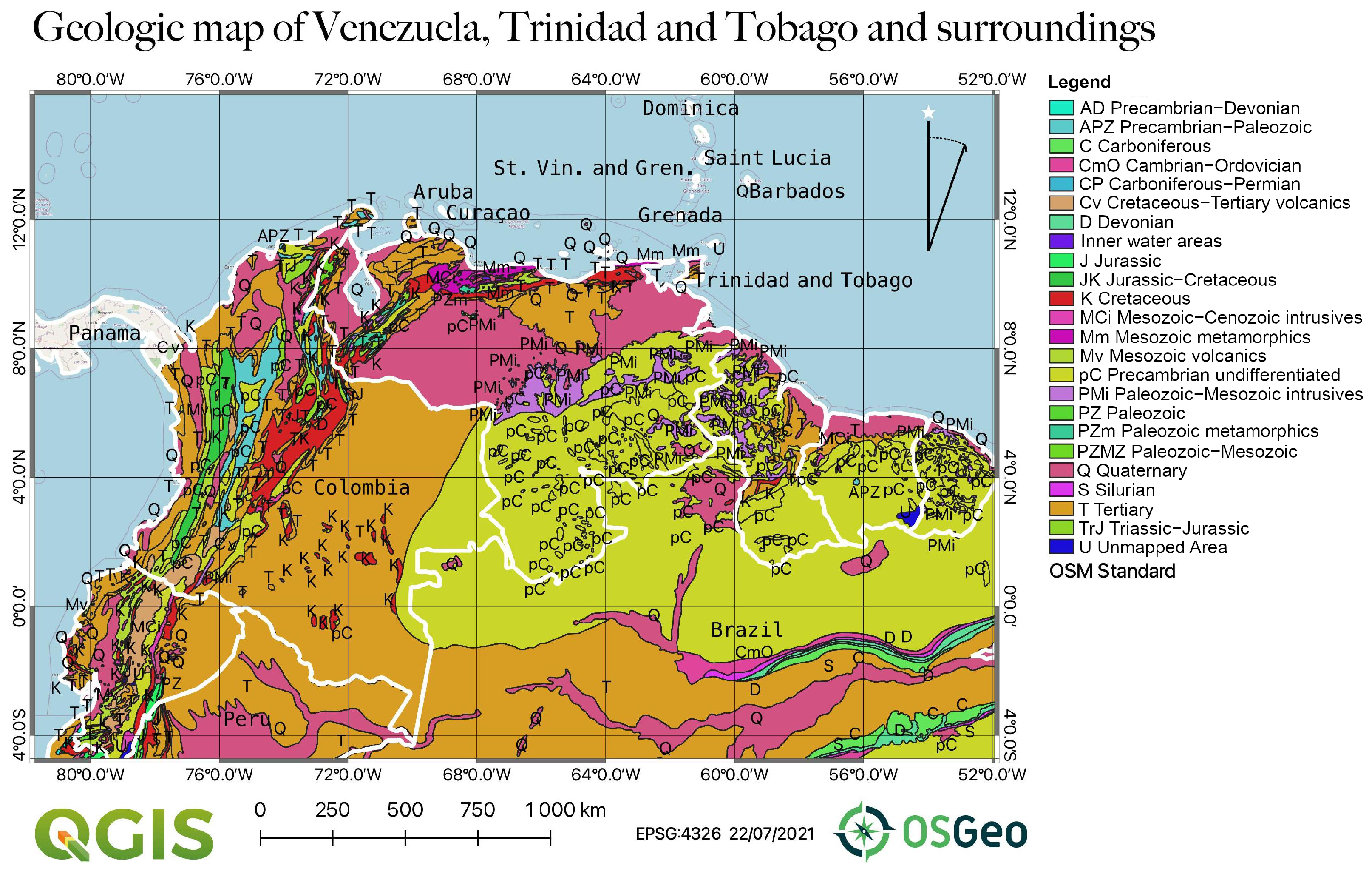
- Hackley, P.; Urbani, F.; Karlsen, A.W.; Garrity, C.P. Geologic Shaded Relief Map of Venezuela. U.S. Geological Survey, Open File Report 2005–1038, 2006. Available online: https://pubs.usgs.gov/of/2005/1038/index.htm (accessed on 1 November 2022).
- Schmitz, M.; Ramírez, K.; Mazuera, F.; Ávila, J.; Yegres, L.; Bezada, M.; Levander, A. Moho depth map of northern Venezuela based on wide-angle seismic studies. J. S. Am. Earth Sci. 2021, 107, 103088. [Google Scholar] [CrossRef]
- Sun, C.G.; Chun, S.H.; Ha, T.G.; Chung, C.K.; Kim, D.S. Development and application of a GIS-based tool for earthquake-induced hazard prediction. Comput. Geotech. 2008, 35, 436–449. [Google Scholar] [CrossRef]
- Escalona, A.; Mann, P. Tectonics, basin subsidence mechanisms, and paleogeography of the Caribbean-South American plate boundary zone. Thematic Set on: Tectonics, basinal framework, and petroleum systems of eastern Venezuela, the Leeward Antilles, Trinidad and Tobago, and offshore areas. Mar. Pet. Geol. 2011, 28, 8–39. [Google Scholar] [CrossRef]
- Dhont, D.; Monod, B.; Hervouët, Y.; Backé, G.; Klarica, S.; Choy, J.E. 3D geological modeling of the Trujillo block: Insights for crustal escape models of the Venezuelan Andes. J. Am. Earth Sci. 2012, 39, 245–251. [Google Scholar] [CrossRef]
- Masy, J.; Niu, F.; Levander, A.; Schmitz, M. Mantle flow beneath northwestern Venezuela: Seismic evidence for a deep origin of the Mérida Andes. Earth Planet. Sci. Lett. 2011, 305, 396–404. [Google Scholar] [CrossRef]
- Pérez, O.J.; Wesnousky, S.G.; De La Rosa, R.; Márquez, J.; Uzcátegui, R.; Quintero, C.; Liberal, L.; Mora-Páez, H.; Szeliga, W. On the interaction of the North Andes plate with the Caribbean and South American plates in northwestern South America from GPS geodesy and seismic data. Geophys. J. Int. 2018, 214, 1986–2001. [Google Scholar] [CrossRef]
- Suárez, G.; Nábělek, J. The 1967 Caracas Earthquake: Fault geometry, direction of rupture propagation and seismotectonic implications. J. Geophys. Res. 1990, 95, 17459–17474. [Google Scholar] [CrossRef]
- Audemard, F.A. Néotectonique, Sismotectonique et aléa Sismique du nord-ouest du Vénézuela (Système de Failles d’Oca-Ancón). Ph.D. Thesis, University of Montpellier I, Montpellier, France, 1993; 369p. [Google Scholar]
- Backé, G.; Dhont, D.; Hervouët, Y. Spatial and temporal relationships between compression, strike-slip and extension in the Central Venezuelan Andes: Clues for Plio-Quaternary tectonic escape. Tectonophysics 2006, 425, 25–53. [Google Scholar] [CrossRef]
- Marshall, J.L.; Russo, R.M. Relocated aftershocks of the March 10, 1988 Trinidad earthquake: Normal faulting, slab detachment and extension at upper mantle depths. Tectonophysics 2005, 398, 101–114. [Google Scholar] [CrossRef]
- Reinoza, C.; Jouanne, F.; Audemard, F.A.; Schmitz, M.; Beck, C. Geodetic exploration of strain along the El Pilar Fault in northeastern Venezuela. J. Geophys. Res. Solid Earth 2015, 120, 1993–2013. [Google Scholar] [CrossRef]
- Harbitz, C.B.; Glimsdal, S.; Bazin, S.; Zamora, N.; Løvholt, F.; Bungum, H.; Smebye, H.; Gauer, P.; Kjekstad, O. Tsunami hazard in the Caribbean: Regional exposure derived from credible worst case scenarios. Cont. Shelf Res. 2012, 38, 1–23. [Google Scholar] [CrossRef]
- Audemard, F.A. Revised seismic history of the El Pilar fault, Northeastern Venezuela, from the Cariaco 1997 earthquake and recent preliminary paleoseismic results. J. Seismol. 2007, 11, 311–326. [Google Scholar] [CrossRef]
- Pérez, O.J.; Sanz, C.; Lagos, G. Microseismicity, tectonics and seismic potential in southern Caribbean and northern Venezuela. J. Seismol. 1997, 1, 15–28. [Google Scholar] [CrossRef]
- Barr, K.G.; Robson, G.R. Seismic Delays in the Eastern Caribbean. Geophys. J. Int. 1963, 7, 342–349. [Google Scholar] [CrossRef][Green Version]
- Hayes, G.P.; Mcnamara, D.E.; Seidman, L.; Roger, J. Quantifying potential earthquake and tsunami hazard in the Lesser Antilles subduction zone of the Caribbean region. Geophys. J. Int. 2014, 196, 510–521. [Google Scholar] [CrossRef]
- Audemard, F.A. Surface rupture of the Cariaco July 09, 1997 earthquake on the El Pilar fault, northeastern Venezuela. Tectonophysics 2006, 424, 19–39. [Google Scholar] [CrossRef]
- Baumbach, M.; Grosser, H.; Romero Torres, G.; Rojas Gonzales, J.L.; Sobiesiak, M.; Welle, W. Aftershock pattern of the July 9, 1997 Mw=6.9 Cariaco earthquake in Northeastern Venezuela. Tectonophysics 2004, 379, 1–23. [Google Scholar] [CrossRef]
- Colón, S.; Audemard, F.A.; Beck, C.; Avila, J.; Padrón, C.; De Batist, M.; Paolini, M.; Leal, A.F.; Van Welden, A. The 1900 Mw 7.6 earthquake offshore north–central Venezuela: Is La Tortuga or San Sebastián the source fault? Mar. Pet. Geol. 2015, 67, 498–511. [Google Scholar] [CrossRef]
- Pousse-Beltran, L.; Vassallo, R.; Audemard, F.; Jouanne, F.; Oropeza, J.; Garambois, S.; Aray, J. Earthquake geology of the last millennium along the Boconó Fault, Venezuela. Tectonophysics 2018, 747–748, 40–53. [Google Scholar] [CrossRef]
- Rial, J.A. The Caracas, Venezuela, earthquake of July 1967: A multiple-source event. J. Geophys. Res. Solid Earth 1978, 83, 5405–5414. [Google Scholar] [CrossRef]
- Yamazaki, Y.; Audemard, F.; Altez, R.; Hernández, J.; Orihuela, N.; Safina, S.; Schmitz, M.; Tanaka, I.; Kagawa, H. Estimation of the seismic intensity in Caracas during the 1812 earthquake using seismic microzonation methodology. Revista Geográfica Venezolana 2005, 46, 199–216. [Google Scholar]
- Deville, E.; Guerlais, S.H. Cyclic activity of mud volcanoes: Evidences from Trinidad (SE Caribbean). Mar. Pet. Geol. 2009, 26, 1681–1691. [Google Scholar] [CrossRef]
- Latchman, J.L.; Ambeh, W.B.; Lynch, L.L. Attenuation of seismic waves in the Trinidad and Tobago area. Tectonophysics 1996, 253, 111–127. [Google Scholar] [CrossRef]
- Bucci, M.G.; Tuttle, M.P. Liquefaction Susceptibility and Hazard Mapping: Insights From Case Histories of Earthquake-Induced Liquefaction. Ref. Modul. Earth Syst. Environ. Sci. 2022, 2, 563–582. [Google Scholar] [CrossRef]
- Diebold, J.B.; Stoffa, P.L.; Buhl, P.; Truchan, M. Venezuela Basin crustal structure. J. Geophys. Res. Solid Earth 1981, 86, 7901–7923. [Google Scholar] [CrossRef]
- Fajardo, A.; Aubourg, C.; Nivière, B.; Regard, V.; Uzcátegui, R. Neotectonic evolution of Northeastern Venezuela. Geomorphological and seismic analysis in the Monagas Fold and Thrust Belt. J. S. Am. Earth Sci. 2020, 104, 102867. [Google Scholar] [CrossRef]
- Lemenkova, P. GRASS GIS for topographic and geophysical mapping of the Peru-Chile Trench. Forum Geogr. 2020, 19, 143–157. [Google Scholar] [CrossRef]
- Pérez, O.J.; Aggarwal, Y.P. Present-day tectonics of the southeastern Caribbean and northeastern Venezuela. J. Geophys. Res. Solid Earth 1981, 86, 10791–10804. [Google Scholar] [CrossRef]
- Avila-García, J.; Schmitz, M.; Mortera-Gutierrez, C.; Bandy, W.; Yegres, L.; Zelt, C.; Aray-Castellano, J. Crustal structure and tectonic implications of the southernmost Merida Andes, Venezuela, from wide-angle seismic data analysis. J. S. Am. Earth Sci. 2022, 116, 103853. [Google Scholar] [CrossRef]
- Gough, D.I.; Heirtzler, J.R. Magnetic Anomalies and Tectonics of the Cayman Trough. Geophys. J. Int. 1969, 18, 33–49. [Google Scholar] [CrossRef]
- Lemenkova, P. Geomorphology of the Puerto Rico Trench and Cayman Trough in the Context of the Geological Evolution of the Caribbean Sea. Ann. Univ. Mariae-Curie-Sklodowska, Sect. Geogr. Geol. Mineral. Petrogr. 2020, 75, 115–141. [Google Scholar] [CrossRef]
- Bezada, M.J.; Schmitz, M.; Jácome, M.I.; Rodríguez, J.; Audemard, F.; Izarra, C. Crustal structure in the Falcón Basin area, northwestern Venezuela, from seismic and gravimetric evidence. J. Geodyn. 2008, 45, 191–200. [Google Scholar] [CrossRef]
- Mazuera, F.; Schmitz, M.; Escalona, A.; Zelt, C.; Levander, A. Lithospheric structure of northwestern Venezuela from wideangle seismic data: Implications for the understanding of continental margin evolution. J. Geophys. Res. Solid Earth 2019, 124, 13124–13149. [Google Scholar] [CrossRef]
- Group, G.C. GEBCO 2020 Grid, 2020. Available online: https://www.bodc.ac.uk/data/published_data_library/catalogue/10.5285/a29c5465-b138-234d-e053-6c86abc040b9/ (accessed on 1 November 2022).
- Schenke, H. General Bathymetric Chart of the Oceans (GEBCO). In Encyclopedia of Earth Sciences Series; Chapter Encyclopedia of Marine Geosciences; Springer: Dordrecht, The Netherlands, 2016; pp. 268–269. [Google Scholar] [CrossRef]
- Mcmichael-Phillips, J. The Nippon Foundation-GEBCO Seabed 2030 Project: The Most Ambitious Seafloor Mapping Initiative in History. Mar. Technol. Soc. J. 2021, 55, 25–28. [Google Scholar] [CrossRef]
- Cortina, G.C.Z.; Wigley, R.; Pe’eri, S. The GEBCO and NOAA Chart Adequacy Workshop. In Abstracts of the International Cartographic Conference (ICA); ICA: Bern, Switzerland, 2019; Chapter 1; p. 51. [Google Scholar] [CrossRef]
- Lemenkova, P. Tanzania Craton, Serengeti Plain and Eastern Rift Valley: Mapping of geospatial data by scripting techniques. Est. J. Earth Sci. 2022, 71, 61–79. [Google Scholar] [CrossRef]
- Pavlis, N.K.; Holmes, S.; Kenyon, S.C.; Factor, J.K. The development and evaluation of the Earth Gravitational Model 2008 (EGM2008). J. Geophys. Res. 2012, 117, B04406. [Google Scholar] [CrossRef]
- Sandwell, D.T.; Müller, R.D.; Smith, W.H.F.; Garcia, E.; Francis, R. New global marine gravity model from CryoSat-2 and Jason-1 reveals buried tectonic structure. Science 2014, 7346, 65–67. [Google Scholar] [CrossRef]
- Lemenkova, P. Console-Based Mapping of Mongolia Using GMT Cartographic Scripting Toolset for Processing TerraClimate Data. Geosciences 2022, 12, 140. [Google Scholar] [CrossRef]
- Lemenkova, P. Mapping Climate Parameters over the Territory of Botswana Using GMT and Gridded Surface Data from TerraClimate. ISPRS Int. J. Geo-Inf. 2022, 11, 473. [Google Scholar] [CrossRef]
- Lemenkova, P. Topography of the Aleutian Trench south-east off Bowers Ridge, Bering Sea, in the context of the geological development of North Pacific Ocean. Baltica 2021, 34, 27–46. [Google Scholar] [CrossRef]
- Lemenkova, P. The visualization of geophysical and geomorphologic data from the area of Weddell Sea by the Generic Mapping Tools. Stud. Quat. 2021, 38, 19–32. [Google Scholar] [CrossRef]
- Callejón, A.F.; von der Dick, H.H. Numerical identification of microseeps insurface soil gases of western Venezuela, and its significance for hydrocarbon exploration. In Surface Exploration Case Histories: Applications of Geochemistry, Magnetics, and Remote Sensing; AAPG Studies in Geology 48 and SEG Geophysical References Series; AAPG: Tulsa, OK, USA, 2002; Volume 11, pp. 381–392. [Google Scholar]
- De Rodriguez, G. Fundamental Geological Characteristics of the Venezuelan Oil Basins. In Proceedings of the 3rd World Petroleum Congress, The Hague, The Netherlands, 28 May–6 June 1951. [Google Scholar]
- Mann, P.; Kroehler, M.; Escalona, A.; Magnani, B.; Christeson, G. Subduction Along the South Caribbean Deformed Belt: Age of Initiation and Backthrust Origin. In American Geophysical Union; Fall Meeting 2007; AGU: Washington, DC, USA, 2007; Chapter Abstract ID. T11D-02; p. 2. [Google Scholar]
- Rodríguez, I.; Bulnes, M.; Poblet, J.; Masini, M.; Flinch, J. Structural style and evolution of the offshore portion of the Sinu Fold Belt (South Caribbean Deformed Belt) and adjacent part of the Colombian Basin. Mar. Pet. Geol. 2021, 125, 104862. [Google Scholar] [CrossRef]
- Schubert, C. Origin of the Cariaco Basin, Southern Caribbean Sea. Mar. Geol. 1982, 47, 345–360. [Google Scholar] [CrossRef]
- Speed, R.; Torrini, R.; Smith, P.L. Tectonic evolution of the Tobago Trough forearc basin. J. Geophys. Res. 1989, 94, 2913–2936. [Google Scholar] [CrossRef]
- Dhont, D.; Backé, G.; Hervouët, Y. Plio-Quaternary extension in the Venezuelan Andes: Mapping from SAR JERS imagery. Tectonophysics 2005, 399, 293–312. [Google Scholar] [CrossRef]
- Gibbs, A.K.; Barron, C.N. Geology of the Guiana Shield; Clarendon Press: Oxford, UK, 1993; Volume 22, 246p. [Google Scholar]
- Hollowell, T.; Reynolds, R.P. Checklist of the Terrestrial Vertebrates of the Guiana Shield. In Bulletin of the Biological Society of Washington; Biological Society of Washington: Washington, DC, USA, 2005; Chapter 13; pp. 1–106. [Google Scholar]
- Hammond, D.S. Tropical Forests of the Guiana Shield; CABI Publishing: Wallingford, UK, 2005. [Google Scholar]
- Escalona, A.; Mann, P. An overview of the petroleum system of Maracaibo Basin. AAPG Bull. 2006, 90, 657–678. [Google Scholar] [CrossRef]
- Bockmeulen, H.; Barker, C.; Dickey, P.A. Geology and geochemistry of crude oils, Bolivar coastal fields, Venezuela. AAPG Bull. 1983, 67, 242–270. [Google Scholar] [CrossRef]
- Escobar, M.; Márquez, G.; Inciarte, S.; Rojas, J.; Esteves, I.; Malandrino, G. The organic geochemistry of oil seeps from the Sierra de Perijá eastern foothills, Lake Maracaibo Basin, Venezuela. Org. Geochem. 2011, 42, 727–738. [Google Scholar] [CrossRef]
- Memon, A.; Borman, C.; Mohammadzadeh, O.; Garcia, M.; Tristancho, D.J.R.; Ratulowski, J. Systematic evaluation of asphaltene formation damage of black oil reservoir fluid from Lake Maracaibo, Venezuela. Fuel 2017, 206, 258–275. [Google Scholar] [CrossRef]
- Li, X.; Götze, H.J. Ellipsoid, geoid, gravity, geodesy, and geophysics. Geophysics 2001, 66, 1660–1668. [Google Scholar] [CrossRef]
- Yilmaz, M.; Kozlu, B. The Comparison of Gravity Anomalies based on Recent High-Degree Global Models. Afyon Kocatepe Univ. J. Sci. Eng. 2018, 18, 981–990. [Google Scholar] [CrossRef]
- Guenther, F.B. Relations between Pasadena magnitude and vertical ground acceleration from long distance earthquakes, derived by gravity earthtide measurements at Caracas, Venezuela. Phys. Earth Planet. Inter. 1980, 21, 261–266. [Google Scholar] [CrossRef]
- Schmitz, M.; Avila, J.; Bezada, M.; Vieira, E.; Yáñez, M.; Levander, A.; Zelt, C.A.; Jácome, M.I.; Magnani, M.B. Crustal thickness variations in Venezuela from deep seismic observations. Tectonophysics 2008, 459, 14–26. [Google Scholar] [CrossRef]
- Ambeh, W.B.; Lynch, L.L. Coda Q in the Eastern Caribbean, West Indies. Geophys. J. Int. 1993, 112, 507–516. [Google Scholar] [CrossRef]


Publisher’s Note: MDPI stays neutral with regard to jurisdictional claims in published maps and institutional affiliations. |
© 2022 by the authors. Licensee MDPI, Basel, Switzerland. This article is an open access article distributed under the terms and conditions of the Creative Commons Attribution (CC BY) license (https://creativecommons.org/licenses/by/4.0/).
Share and Cite
Lemenkova, P.; Debeir, O. Seismotectonics of Shallow-Focus Earthquakes in Venezuela with Links to Gravity Anomalies and Geologic Heterogeneity Mapped by a GMT Scripting Language. Sustainability 2022, 14, 15966. https://doi.org/10.3390/su142315966
Lemenkova P, Debeir O. Seismotectonics of Shallow-Focus Earthquakes in Venezuela with Links to Gravity Anomalies and Geologic Heterogeneity Mapped by a GMT Scripting Language. Sustainability. 2022; 14(23):15966. https://doi.org/10.3390/su142315966
Chicago/Turabian StyleLemenkova, Polina, and Olivier Debeir. 2022. "Seismotectonics of Shallow-Focus Earthquakes in Venezuela with Links to Gravity Anomalies and Geologic Heterogeneity Mapped by a GMT Scripting Language" Sustainability 14, no. 23: 15966. https://doi.org/10.3390/su142315966
APA StyleLemenkova, P., & Debeir, O. (2022). Seismotectonics of Shallow-Focus Earthquakes in Venezuela with Links to Gravity Anomalies and Geologic Heterogeneity Mapped by a GMT Scripting Language. Sustainability, 14(23), 15966. https://doi.org/10.3390/su142315966