Article

Multi-Level Comprehensive Assessment of Constructed Wetland Ecosystem Health: A Case Study of Cuihu Wetland in Beijing, China

School of Ecology and Nature Conservation, Beijing Forestry University, Beijing 100083, China
*
Authors to whom correspondence should be addressed.
Sustainability 2022, 14(20), 13439; https://doi.org/10.3390/su142013439
Submission received: 21 September 2022 / Revised: 10 October 2022 / Accepted: 13 October 2022 / Published: 18 October 2022
(This article belongs to the Special Issue Sustainable Management and Conservation of Wetland Ecology)

Abstract

:
Wetlands are one of the world’s three major ecosystems. They not only maintain regional ecological balance but also provide an important guarantee for human survival. Wetland ecosystem health assessment serves as the foundation for wetland protection, management, and restoration. In this study, the method for wetland ecosystem health assessment proposed by the United States Environmental Protection Agency (US EPA) was selected and improved to systematically evaluate the health status of the Cuihu wetlands’ ecosystem at three levels. The results revealed that the Cuihu wetlands’ landscape development intensity index was 1.55, the total landscape pattern value was 10 points, and the total score for rapid evaluation was 0.79. Levels I and II indicated that the Cuihu wetlands’ ecosystem was in a good near-natural state. Additionally, level III revealed that ecosystem health is higher in area B than in area A. The Cuihu wetlands were characterized by low species diversity and low distribution of benthic animals and aquatic plants. The comprehensive evaluation results revealed that the Cuihu wetlands’ ecosystem is in a good health. In the future, the health status of the wetland ecosystem should be monitored regularly, the cultivation and propagation of aquatic plants should be strengthened, and effective methods to improve water quality and reduce soil salinity should be used to achieve the best health status of the Cuihu wetlands.

1. Introduction

Wetlands are the transition zone between terrestrial and aquatic ecosystems [1,2], and one of the most complex ecosystems on the planet [3,4], with irreplaceable ecological functions [5,6]. Wetlands are known as the earth’s kidneys because they play an important role in flood control and water storage, climate regulation, water purification, humidification, and cooling. Wetlands are also known as biological supermarkets because they provide a living environment for animals and plants [7,8]. Wetlands are one of the most valuable ecosystems, with services they provide per hectare per year valued at USD 14,785 [9,10,11]. Recently, with the increasing urbanization and human activities, wetlands around the world are facing severe challenges. Wetland ecosystems are suffering structural damage, gradual functional decline, significant reductions in wetland area, reduced biodiversity, severe water pollution, and eutrophication of water bodies [12,13,14]. All of these issues indicate that the health of the wetland ecosystem has been severely damaged [15,16]. This will undoubtedly affect the watershed’s ecological security, as well as pose a threat to the development of the regional economy and human survival. Consequently, it is important to diagnose and evaluate the health of wetland ecosystems [17,18].
The evaluation of wetland ecosystems was pioneered in the United States in the early twentieth century to establish protected areas for migratory birds and rare wetland plants [19,20]. The United States began cataloging and evaluating the major protected species of wetlands in the 1950s [21,22]. The first rapid wetland evaluation model was developed by Larson in the 1970s [17,23,24]. Subsequently, various countries have conducted exploratory and refinement work in studies of wetland health assessment. The Canadian Environmental Protection Agency primarily focuses on the health evaluation index system of lake wetlands and proposes an evaluation system that includes biodiversity indicators, chemical indicators, physical indicators, and social and economic status. Maitby et al. established a pan-European evaluation method of wetland ecosystem functions, conducting comparative studies in Ireland, the United Kingdom, Spain, and other countries and regions and establishing a sound evaluation system for riparian wetland systems [25,26,27]. The Australian environmental protection department has also established a set of evaluation systems applicable to the Australian watershed wetland ecosystem, which primarily selects various indicators from environmental change trends, environmental background quality, and social and economic benefits to constructing the system [28,29,30]. Previously, the United States conducted relevant research on wetland assessment and has achieved relatively fruitful results. With the advancement of wetland evaluation research in the United States, the three-level evaluation system established by the Environmental Protection Agency of the United States has gradually become a reference standard for researchers. The method has been used in Florida, Ohio, and other parts of the United States [31].
Recently, China has also made some advances in the assessment of wetland ecosystem health. Wu et al. created an evaluation system based on the Element–Landscape–Society conceptual model to evaluate the health of the Zoige wetlands [17]. Chen et al. used the integrated health index method to evaluate the ecosystem health of 19 wetlands in the Beijing–Tianjin–Hebei region in terms of water, soil, landscape, and social aspects [32]. Wu and Chen developed a set of wetland health evaluation systems consisting of 12 indicators using remote sensing data and experimental data and then applied the system to the Hongze Lake wetlands [33]. The ecosystem health of Chinese inland wetlands was assessed using the Pressure–State–Effect–Response model between 2010 and 2018 [34]. A Pressure–State–Response model was used to assess the ecosystem health of coastal wetland vegetation in the Liao River Estuary [35]. Furthermore, index of biotic integrity (IBI) methods began to be widely used in the health evaluation of wetlands [36,37,38,39,40]. Different types of wetlands have been studied, primarily river and lake wetlands, but the evaluations of constructed wetlands are scarce. Overall, China has yet to establish unified evaluation criteria for the various types of wetlands.
Based on the comprehensive review of the literature, it can be found that most of the wetland ecosystem health assessment studies are still in the stage of single-level assessment. The evaluation methods mainly include species indicator method, PSR model, integrated index method, landscape pattern index, etc. However, the accuracy of single-level evaluation results is often not verified and has certain shortcomings. Furthermore, the proportion of constructed wetland area in Beijing is 52.5%, and its function and role are becoming more and more important during the process of urban development. Currently, research on constructed wetlands is more focused on functional services, such as wastewater absorption, conversion, and treatment [4,41,42], and little research has been reported on the ecosystem health evaluation. Studies on the ecosystem health assessment of constructed wetlands need to be strengthened and advanced. The Cuihu wetland, as a typical case of an urban constructed wetland, has a wide range of promotional significance, based on the analysis of the research, and helps to promote the construction of urban wetland parks.
Therefore, this study adopted the three-level evaluation system proposed by the US EPA to comprehensively evaluate the health status of the Cuihu wetland ecosystem from different levels, in conjunction with the ecological environment of the study area. It is hoped that the results of the study will help enrich the evaluation system of urban constructed wetland ecosystem health and serve as a guide for the management of the Cuihu wetland.

2. Materials and Methods

2.1. Study Area

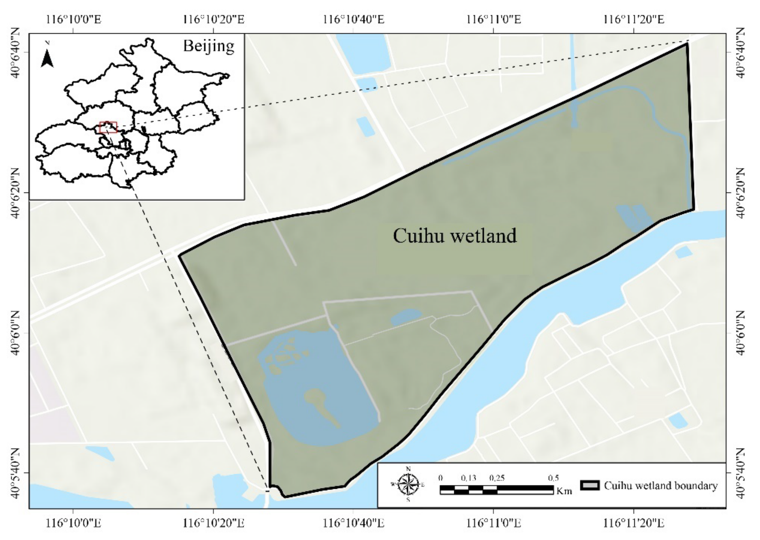
The Cuihu wetland is located in the Shangzhuang area in the northern part of the Haidian District, Beijing. The geographical coordinates are 116°10′ E and 40°06′ N. The terrain is high in the northwest and low in the southeast. The Cuihu wetland covers an area of 157.16 hm2, a length of 1.9 km from east to west, and a width of 1.2 km from north to south and is divided into three zones: a closed protection zone, a transitional buffer zone, and an open experience zone. The Cuihu wetland has a temperate continental monsoon climate, with cold and dry winters with mostly northwestern winds, and hot and rainy summers with prevailing southeastern winds. The artificially restored wetland is considered its distinguishing feature, with various functions such as biodiversity conservation, water environment protection, science education, and ecological viewing experience (Figure 1).

2.2. Level I: Landscape Comprehensive Assessment Method

2.2.1. Basic Data Sources and Processing

The basic data used in the comprehensive landscape evaluation method include the Cuihu wetland park planning map, 1:50,000 topographic map, and resources such as satellite III remote sensing images. The remote sensing images were obtained from secondary images provided by the resources of satellite III in October 2012. First, the land type of Cuihu wetland was determined through a field investigation. The characteristics and boundaries of various land types in the Cuihu wetland were then analyzed on the topographic map, and indoor interpretation signs were installed. Furthermore, remote sensing image processing software (ENVI 5.2) was used to cut out the image of the Cuihu wetland [43,44]. The cut image was then geometrically corrected using a 1:50,000 topographic map (the correction error was less than 0.5 image elements). Finally, the corrected remote sensing image was enhanced with 2% clipping and stretching.

2.2.2. Landscape Development Intensity Index (LDI)

The landscape development intensity index determines the LDI coefficient by dividing the study area’s land-use types and calculating the energy value. Brown and Vivas studied how to calculate the LDI coefficient using nonrenewable energy input and provided a detailed explanation [45]. This study also refers to the LDI coefficient proposed by Brown and Vivas to assign the LDI coefficient to each land-use type. The landscape-development-intensity composite index was calculated using the following formula:
LDItotal = ∑ %Lui * LDIi,
In the formula, LDItotal indicates the LDI value of a certain land type. %LUi denotes the percentage of the area of the i-th land type to the total area of the study area. LDIi represents the landscape development intensity coefficient of the i-th land type.

2.2.3. Landscape Pattern Assessment Method

First, using ArcView 3.1 and FRAGSTATS 3.3 software [46,47,48], the fused remote sensing image is used as the information source to interpret, which is interpreted by human–computer interaction, and data of each landscape type in the study area is obtained. The six landscape patterns are construction land, wetland vegetation, woodland, open space, water body, and grassland. The landscape Shannon’s diversity index (SHDI), dominance index (DI), patch fractal dimension (PFD), and fragmentation index (FI) of the study area were then calculated and analyzed. The four indicator calculation methods are shown in Table 1.
H = i = 1 m PilnPi
DI = H max + i = 1 m Pi 1 nPi
D = 2 ln p 4 / ln ( A )
FI = MPS   ( Nf 1 ) / Nc  

2.3. Level II: Rapid Assessment Method

The rapid evaluation method necessitates a combination of field investigation and indoor statistics to select some monitoring indicators for the assignment calculation of wetland conditions in the study area. Table 2 shows the specific rapid evaluation indices and evaluation methods. The total evaluation score is calculated by dividing the actual score sum of the seven indicators by their maximum possible score value. The calculation formula is as follows:
Htotal = ∑Hi/MN,
In the formula, Htotal represents the total score of rapid evaluation; Hi is the actual score value of the i-th evaluation index; M is the maximum score value of the i-th evaluation factor; and N is the total number of rapid evaluation indexes.

2.3.1. Qualitative Evaluation Index

The five independent qualitative evaluation indicators were scored using the scoring criteria shown in Table 3, and relevant attribute data were collected. A score of 3 represents a relatively natural state, whereas a score of 0 indicates that the wetland has been severely damaged and heavily influenced by humans.

2.3.2. Quantitative Evaluation Index

This study perfected the rapid evaluation method using two quantitative indices for birds and fish. Bird rarity and native bird index were chosen as indexes for birds. For the fish, the three indicators were selected: the number of indigenous fish species in Beijing, the number of Cypriniformes species, and the percentage of deformed and diseased fish in the total number of quadrats. Finally, each fish and bird index is empowered by experts to determine the final score of all the bird and fish indexes.
Furthermore, the most common methods of bird survey are line transect and sample point. Depending on the season, four surveys were conducted throughout the year. Data on species and numbers of all birds seen within the survey area were collected, and information on the presence of birds in the Cuihu wetland was summarized by reviewing birding records and the published literature. Moreover, the fish survey primarily entails interviewing the fish normally seen by the park staff, gaining a detailed knowledge of the area’s fish composition based on historical documents, and selecting appropriate sample sites to collect fish specimens.

2.4. Level III: Ecosystem Integrity Assessment

2.4.1. Vegetation Index of Biotic Integrity (V-IBI) Assessment

The vegetation integrity survey was conducted during the high biodiversity season to investigate the distribution of inland and aquatic plants in the study area. Quadrats were installed along the edge of each investigated lake, with each sample having a minimum area of 10 m2. The biodiversity of 20 monitoring sites was recorded in situ. As reference loci, four locations with few surrounding pollution sources, a high number of species, and a high vegetation cover were selected. Furthermore, SPSS 21.0 software was used to compare the overlap between the reference points and the damaged sites in the box, specifically the overlap in the 25–75% quantile range. A Pearson correlation analysis was performed on these indicators, and the core indicators were selected by choosing one of the two indicators with correlation |r| > 0.75. The final five core indicators were determined to be the number of wetland emergent plant species, the number of perennial plant species, the percentage of exotic species, the Shannon diversity index, and the flora quality index. Finally, the three-point assignment method was used to assign scores to each V-IBI evaluation indicator. Furthermore, the total value of V-IBI was calculated by adding all core indicators together.

2.4.2. Benthic Index of Biotic Integrity (B-IBI) Assessment

Six sampling sites were designated for collecting benthic organisms. A 1/16 Peterson mud picker is used to collect benthic animals. Samples were collected three times from each sample location. Benthic density and biomass data were collected in the laboratory. The reference sites were selected based on the distribution of benthic organisms during the investigation, as well as the sample locations with high water transparency and low pollution. SPSS 21.0 software was then used to compare the overlap between the reference points and the damaged sites in the box, specifically, the overlap in the 25–75% quantile range. When there is no overlap between the reference point and the damaged point, the box value is 3; when the boxes are partially overlapped but the median values of the reference point and the damaged point are both outside the range of the other box, the box value is 2; and when the median values are within the range of each other’s boxes, the box value is 1. Only the evaluation index with a box value greater than 1 can enter the next step of the analysis. After that, a Pearson correlation analysis was conducted on these indexes. The three core indicators finally screened were as follows: the Shannon diversity index, evenness index, and species richness index. Finally, the three B-IBI evaluation indicators were assigned and scored, and the sum of all indices was calculated to determine the total value of B-IBI.

2.4.3. Environmental Background Quality Assessment

The environmental background quality survey included the collection of 12 soil sample points and 6 water sample points. Soil samples were collected at three different depths (0–10 cm; 10–20 cm; 20–30 cm) using a tubular soil auger, and the collected soil samples were sealed in sealed bags and brought back to the laboratory for the determination of PH, organic matter, total phosphorus, and total nitrogen. Furthermore, six water quality sampling points were set up in Hehuatang, Tianehu, area A, area B, etc. The monitoring cycle was nine months, divided into three quarters: summer, spring and autumn. Finally, the indicators of dissolved oxygen, ammonia nitrogen, total phosphorus, and potassium permanganate index were measured with reference to the Analytical Methods for Water and Wastewater Monitoring.

3. Results

3.1. Level I: Landscape Comprehensive Assessment of Wetland Ecosystem

3.1.1. Assessment of the Landscape Development Intensity Index

The land types in the study area are classified into six categories, including construction land, wetland vegetation, woodland, open space, water body, and grassland. Table 4 shows the LDI coefficients for each land-use type. Additionally, Equation (1) was used to calculate the development intensity coefficient of the Cuihu wetland landscape as 1.55. According to the analysis of LDI values by Brown and Vivas [45], the range of LDI values represents various types of wetlands. The LDI values are in the range of 1.0–2.0, indicating that the wetland is a natural type of wetland with low anthropogenic disturbance; the LDI values in the range of 2.0–5.0 indicate that the wetland is agricultural; and if the LDI value is greater than 5.0, it indicates that the wetland is an urban type wetland with a high level of human disturbance. The Cuihu wetland’s LDI value was 1.55, indicating that it was less affected by human activities and maintained a healthy natural state. The Cuihu wetland is artificially constructed and, thus, belongs to the near-natural type of wetland.
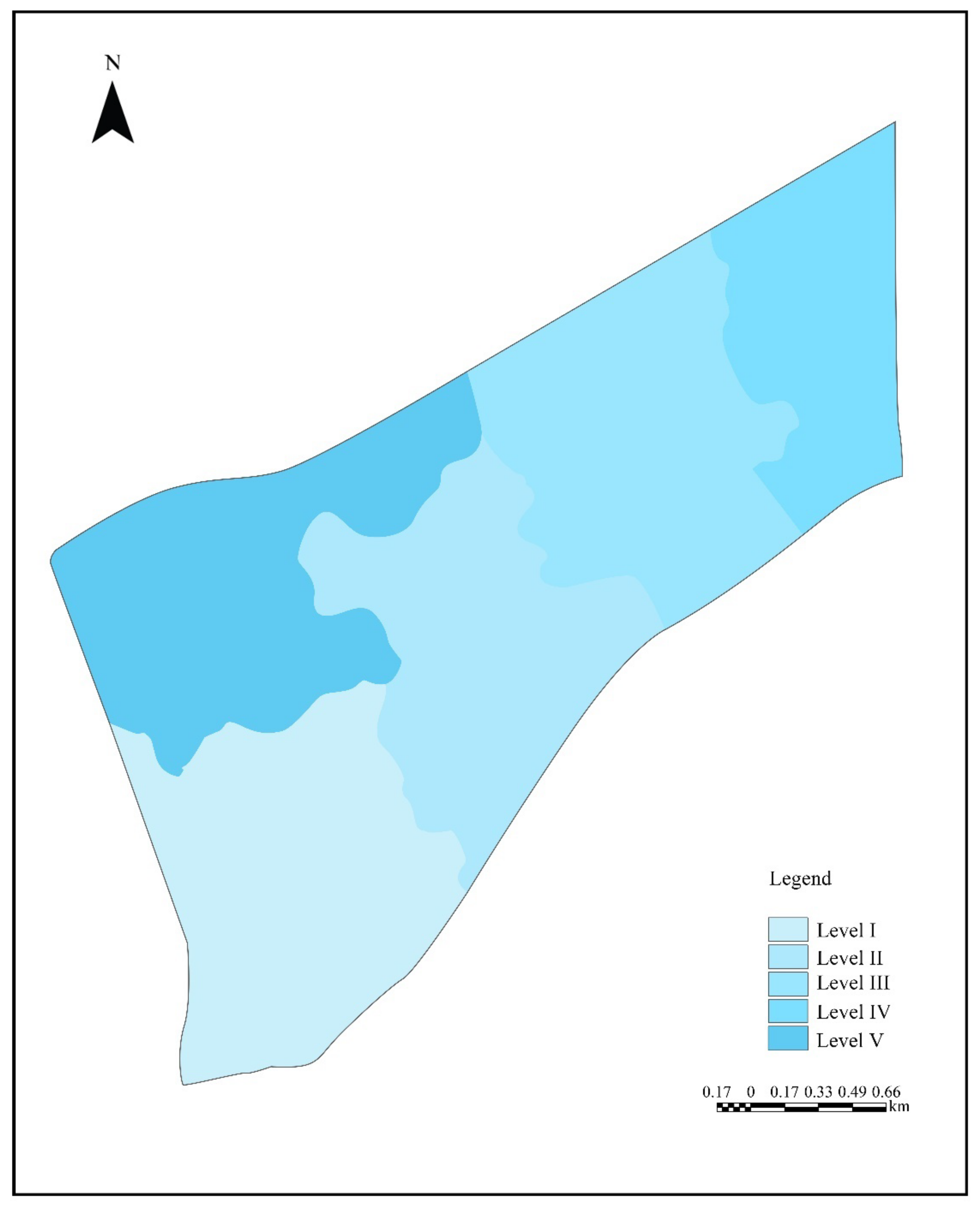
The highest score of the northwest part of Cuihu wetland’s area B of is 1.92, which is close to the category of agricultural wetland proposed by Brown and Vivas [45]. However, there is no farmland distribution in the Cuihu wetland, indicating that the land use in this area is not reasonable. Therefore, in the future tourism development, the regional ecosystem should be strictly monitored and evaluated to prevent the deterioration of the ecosystem health in the region. The LDI index of the middle part of area B and the east part of area A were 1.42, 1.52, and 1.59, respectively. The lowest LDI index was 1.39 in the area around Hehuatang, indicating that the land-use situation in this area was the best, and it was the healthiest under landscape scale evaluation (Figure 2).

3.1.2. Landscape Pattern Assessment

The study area was divided into six landscape types: construction land, wetland vegetation, woodland, open space, water body, and grassland. The Cuihu wetland landscape diversity index, dominance index, patch fractal dimension, and fragmentation index were calculated to be 1.75, 0.65, 1.62, and 0.72, respectively. The results of each index revealed that the landscape pattern of the Cuihu wetland has an aggregated distribution. The main body of the landscape includes grassland, woodland, and wetland vegetation landscape patches. The total area of the water body and woodland occupied 74.5% of the landscape area in the study area, which dominated the landscape. Additionally, the fractional dimension of all types of landscape patches in the Cuihu wetland is greater than 1.5, reflecting the characteristic that each landscape patch is weakly disturbed by humans. The theoretical range of the fragmentation index is 0–1, where 0 indicates that there is no fragmentation phenomenon in the entire landscape, and 1 indicates that the landscape in the study area has presented a state of complete fragmentation. While the Cuihu wetland is part of the artificially constructed wetland landscape, the degree of fragmentation is inversely proportional to the degree of disturbance. That is, the greater the anthropogenic disturbance is, the smaller the fragmentation, indicating that the overall anthropogenic disturbance in the Cuihu wetland is low. Due to the difference in the number of evaluation indicator units, it is difficult to realize the direct calculation of the actual value, so; it is necessary to assign a value to it for calculation. The calculation standardization basis is shown in Table 5 below.

3.1.3. Comprehensive Assessment of the Landscape

The comprehensive evaluation criteria of the Cuihu wetland landscape were divided into three different levels based on the landscape development intensity index and landscape pattern index scores. Table 6 shows that the LDI value is 1.55, and the total value of the landscape pattern is 10 points. This indicates that the Cuihu wetland landscape ecology is in a healthy state. It also has a more complex boundary shape, with little interference from human activities.

3.2. Level II: Rapid Assessment of Wetland Ecosystem

According to statistics released by the Beijing Bird Watching Association in 2010, there were 424 species of wild birds in the Beijing area. The birds observed in the Cuihu wetland accounted for 30.7% of all birds in Beijing. These include four species of birds protected under national first-class key protection and 21 species of birds protected under national second-class key protection. Furthermore, 110 species of birds protected at the municipal level or higher were discovered in the study area. Among them, 13 species were classified as first-class protected wildlife in Beijing, and 72 species were classified as second-class protected wildlife in Beijing, accounting for 67.5% of the total birds in the study area. As can be seen, the Cuihu wetland plays an important role in the conservation of rare and endangered birds. The Cuihu wetland contains 15 fish species from 4 orders, 6 families, and 14 genera. The most common fish species was Cypriniformes, accounting for 66.67% of all fish species. However, the water area of the Cuihu wetland is small, the water is relatively closed, and the food resources are scarce. Consequently, the increase in large individual fish will result in a scarcity of food resources and the degradation of water quality. To avoid many aquatic plants being eaten, large individual Hypophthalmichthys molitrix, Aristichthys nobilis, Cyprinus carpio, and Ctenopharyngodon idella should be properly caught to protect fish resources and water health.
Due to the difference in the number of evaluation indicators, it is difficult to realize a direct comparison of actual values. The calculation standards for bird and fish assignments are shown in Table 7. Furthermore, to eliminate the influence of subjective factors in the rapid evaluation of qualitative indicators, multiple field surveys were conducted by different investigators. The final scores of the five qualitative indicators are as follows: 2, 3, 2, 3, and 2. The scores of the two quantitative indicators were 2.4 and 2.1, respectively. The overall score of the rapid assessment ranges from 0–1, representing the wetland’s health. A score of 0 indicates that the wetland ecosystem was severely damaged, whereas a score of 1 indicates that there was no human disturbance and the wetland remains in a healthy and natural state. According to Formula (6), the Cuihu wetland’s rapid evaluation result score was 0.79, indicating that the wetland ecosystem was in good health. The level II evaluation results were consistent with the level III results.

3.3. Level III: Ecosystem Integrity Assessment

3.3.1. Vegetation Index of Biotic Integrity (V-IBI) Assessment

The survey results show that there are 13 families, 18 genera, and 20 species of hygrophytes in the Cuihu wetland, and most of the submerged and floating plants were wild species. The low species diversity and poor growth of submerged and floating plants in the survey area may be related to the water quality of the lake. Terrestrial plants are classified into 52 families, 108 genera, and 132 species, with the Compositae being the most abundant. Most terrestrial plants are common species in North China. The community structure of plants is evolving from artificial planting to natural growth, and gradually from adapting to the environment to improving the environment, which is conducive to the long-term benign development of plants in wetland parks. Additionally, seven species of invasive plants were discovered in the Cuihu wetland. Most of the invasive plants are annual herbaceous plants that do not currently pose a threat to the Cuihu wetland ecosystem.
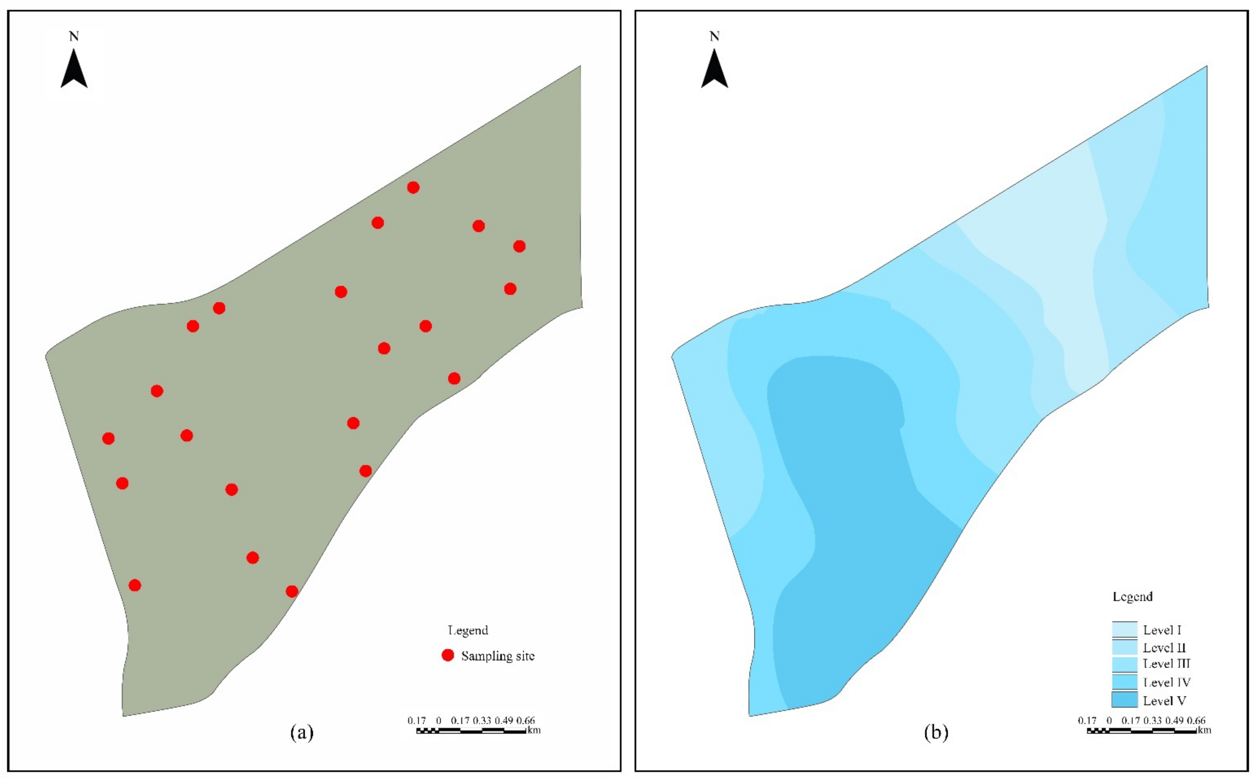
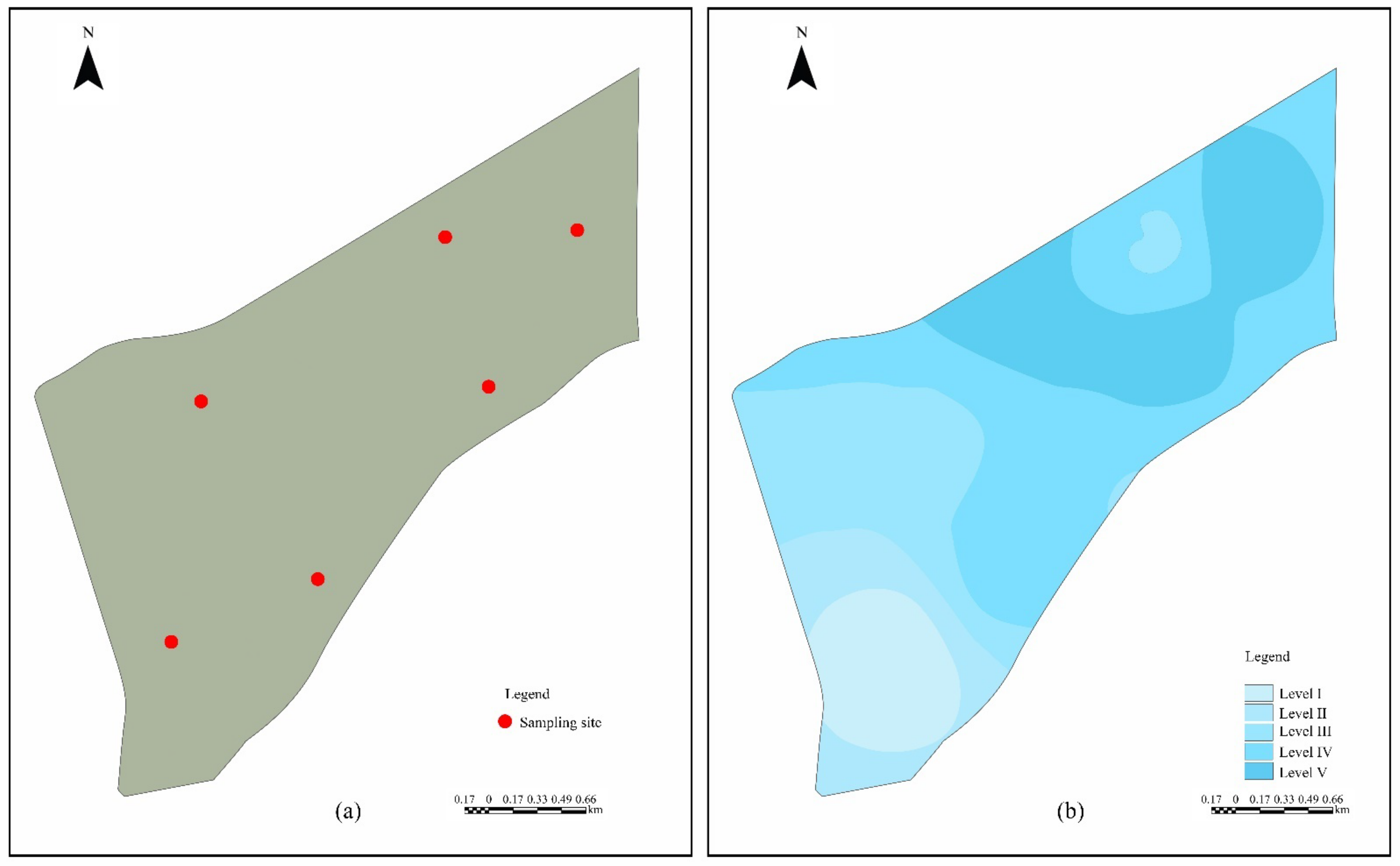
The assigning points standard of vegetation integrity indicators is provided in Table 8. Based on the actual scores of each evaluation index of the four reference sites, the V-IBI evaluation system was built to represent the vegetation health status of various degrees in the study area. The evaluation criterion for the vegetation integrity health of the Cuihu wetland was the 25% quantile of V-IBI values distributed at the reference sites. Table 9 depicts the V-IBI evaluation system of the Cuihu wetland. Among the 20 vegetation integrity monitoring sites in the Cuihu wetland, 4 sites were very healthy, while 3 sites were good. Very healthy and good sites accounted for 35% of the total number of sites. Seven sites were considered general, accounting for 35% of the total sites. Two sites were deemed poor, whereas four sites were deemed extremely poor. The poor and very poor sites accounted for 30% of the total number of sites. According to the survey results of 20 monitoring sites, the Shannon diversity index of plants in the Cuihu wetland ranged between 1.37–2.42. Generally, the species diversity of terrestrial plants is rich, whereas floating leaf and submerged plants have limited distribution areas, low quantity, low coverage, and poor growth.
The monitoring sites with very healthy status are distributed around Tianehu and Hehuatang in area B. The monitoring sites that remain in good condition are located around Tianehu, Bianjinghu, and Dayanjinghu in area B. The monitoring points of the general state are mainly located at the junction of area A and area B and the marginal territory of Cuihu wetland. The monitoring sites were poor and very poor sites distributed in the southwest of area A. The V-IBI evaluation results of Cuihu wetland showed that the health degree of area B was up to level V, and most areas were level IV and level III, indicating that the regional ecosystem was in a good state. However, most areas in area A are level I, and fewer areas are level II, with significantly lower plant diversity than in area B (Figure 3).

3.3.2. Benthic Index of Biotic Integrity (B-IBI) Assessment

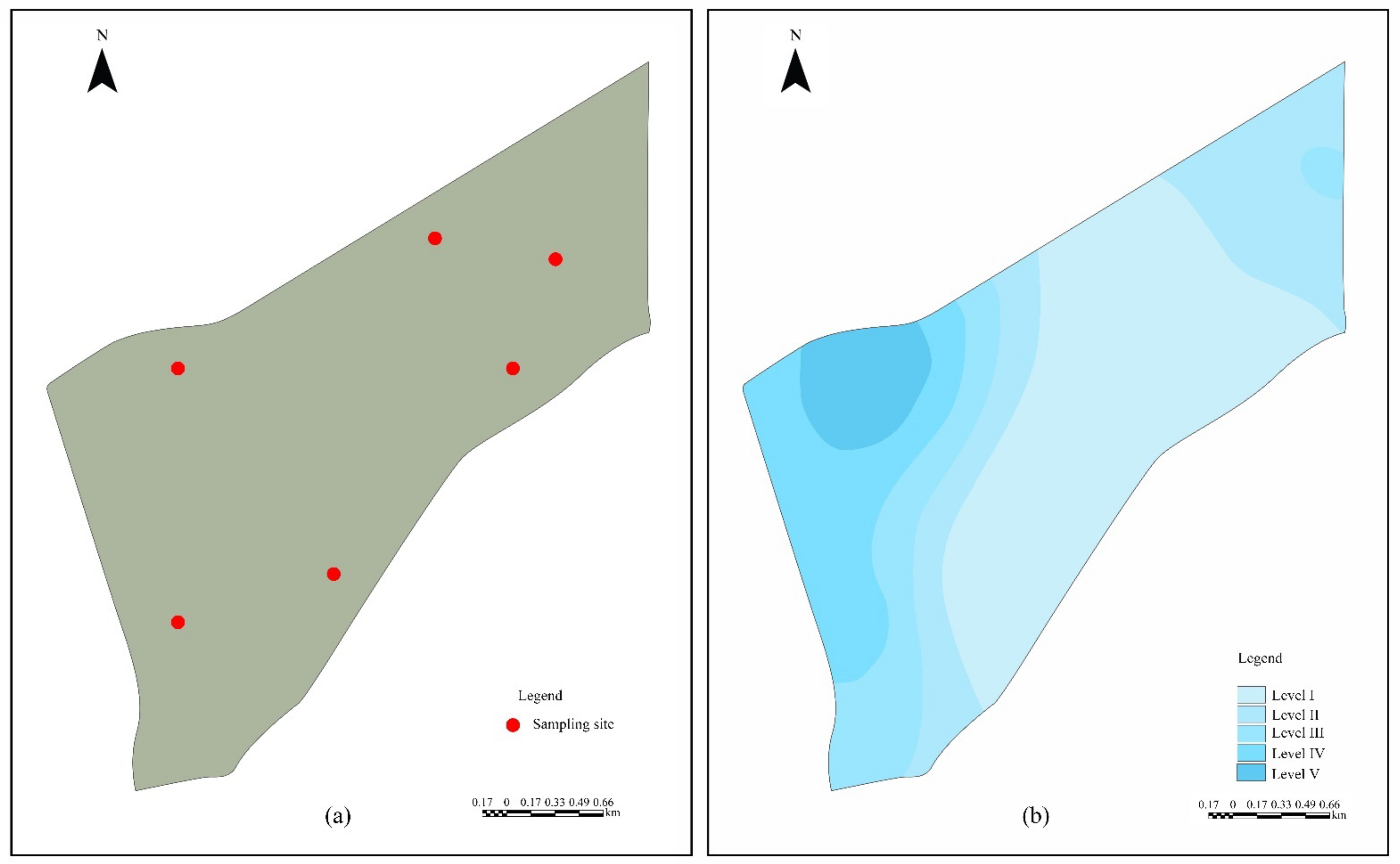
During the survey, eight species from seven families and eight genera of benthic animals were collected. The proportions of the number of individuals of mollusks, arthropods, aquatic insects, and annelids were 17.74%, 79.45%, 1.37%, and 1.37%, respectively. The assigning points standard of B-IBI indicators is shown in Table 10. Furthermore, the 25% quantile of the B-IBI value of the reference site is 12. The Cuihu wetland’s B-IBI evaluation system is shown in Table 9. There were six monitoring sites for the benthic organisms in the Cuihu wetland, with one site being very healthy, one good, one poor, and three very poor, with the poor and very poor sites accounting for 66% of the total number of sites.
The monitoring points that reached very healthy and good status were distributed in the Tianehu area in area B. Overall, the Shannon diversity index of benthic organisms ranged from 0–0.693, indicating that benthic organism diversity was low, the distribution of species was few, and the health status was poor. The very poor and poor sites were mostly distributed in the area A. The B-IBI evaluation results showed that the highest level of health in area B reached level V, and most of the area was level IV and level III, and the ecosystem of the area was in good condition. In contrast, most areas in area A were level I, and fewer areas were level II, with significantly lower benthic animal diversity than in area B (Figure 4). As an artificial restoration wetland around the city, the Cuihu wetland serves as a sewage purification facility. The sampling results revealed that the number and species of benthic animals in the Cuihu wetland were low, as was their diversity. A long-term water quality purification and biodiversity monitoring program should be developed to provide a more suitable habitat for the benthic organisms in the Cuihu wetland.

3.3.3. Environmental Background Quality Assessment

The mean values of PH, organic matter, total phosphorus, and total nitrogen of twelve soil sample sites were spatially interpolated and assigned with equal spacing grading, and the soil fertility evaluation system was obtained (Table 11). The indicators were weighted according to the soil fertility grading standards recommended by the second national soil survey, which were 0.2, 0.3, 0.25, and 0.25, respectively. The soil fertility of Cuihu wetland area B is higher than that of area A (Figure 5). The soil fertility around the Hehuatang was better, while the soil fertility in the northern part of area A was poorer. The contents of total phosphorus, total nitrogen, and organic matter in area B were significantly higher than those in area A, indicating that the wetland ecosystem in area B had better resilience and stability. The survey results showed that the soil moisture content of Cuihu wetland was moderate, and the contents of organic matter, total nitrogen, and total phosphorus were low.
Factor analysis method was used to evaluate comprehensively the water quality of the Cuihu wetland. The evaluation criteria of each indicator are shown in Table 12. Through factor standardization analysis and contribution rate ranking of all sample points, the weight of the ranking was the weight coefficient of the comprehensive analysis, and the water environmental quality grade map of the study area was obtained. The water quality in the Cuihu wetland area A was better than that in area B, especially in terms of the ammonia nitrogen, total phosphorus, and permanganate index (Figure 6). Therefore, the improvement of water quality in the Cuihu wetland area B should be strengthened, especially the permanganate index and total phosphorus content.
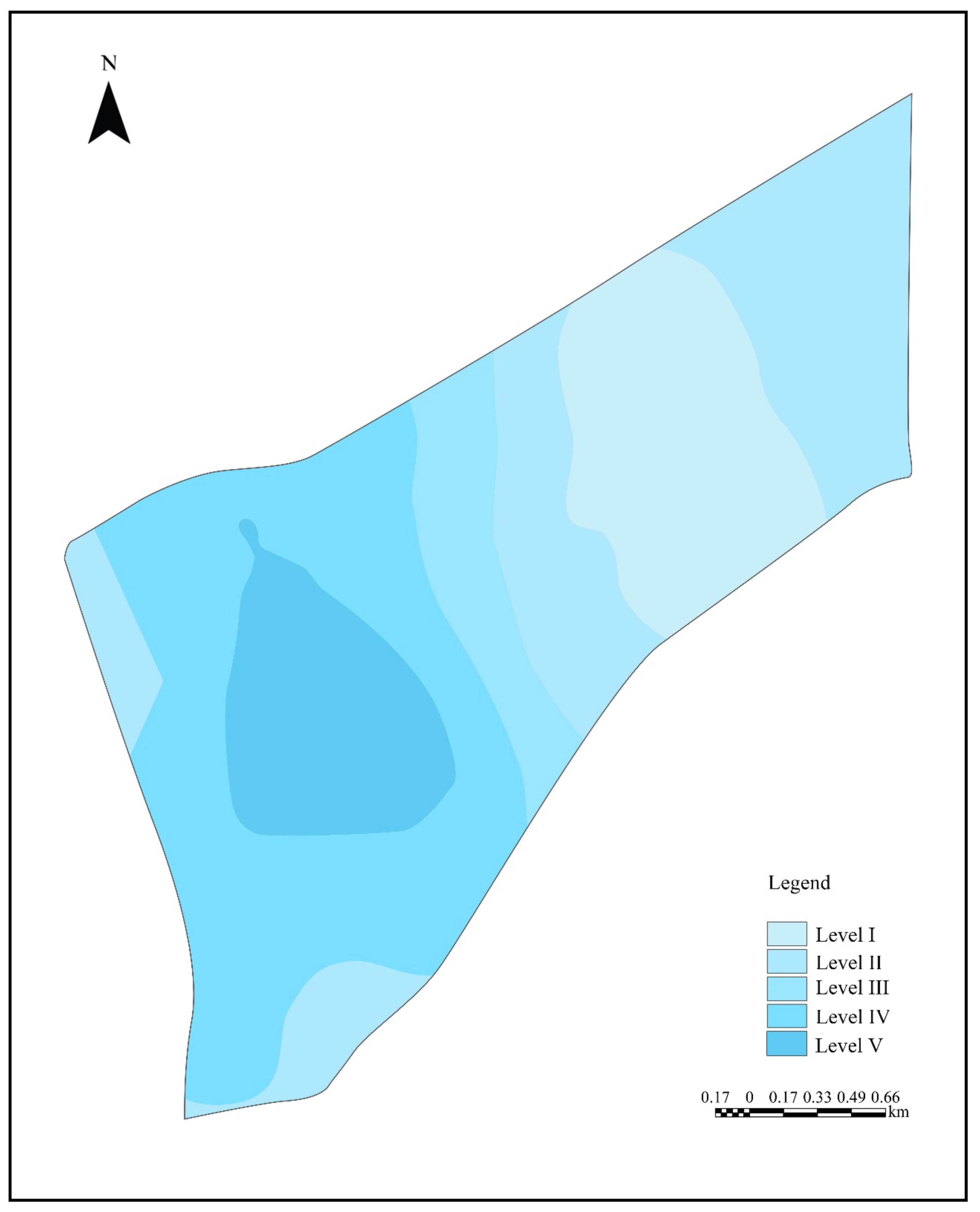
The environmental background quality assessment of the Cuihu wetland is composed of two parts: soil fertility evaluation and water quality evaluation. Based on the actual sampling survey of soil environment and water environment, the grading status of soil environment and water environment quality rating factors was analyzed. The comprehensive assessment of the environmental background quality of the Cuihu wetland was obtained by using the Delphi method to assign weights (Figure 7).

3.3.4. Ecosystem Integrity Evaluation Results

The evaluation results of environmental background quality and biological integrity of the Cuihu wetland were analyzed by spatial superposition with equal weights, and finally the comprehensive evaluation results of ecosystem integrity of the Cuihu wetland were obtained. The comprehensive evaluation results show that the highest health level in area B reaches level V, with most areas at level IV and level III. While most of the area in A was level I, other areas were level II. Generally speaking, the ecosystem in area B is healthier than area A (Figure 8).

4. Discussion

In the previous studies on the wetland ecosystem health assessment, most researchers chose natural wetlands for ecosystem health assessment, while studies on the evaluation of the health status of constructed wetlands were lacking. The effectiveness of conservation, management and restoration of constructed wetlands does not provide timely feedback to the relevant managers. Therefore, this study utilized the United States’ three-level framework wetland assessment method to evaluate the health of the Cuihu wetland ecosystem from different scales. On the one hand, it is hoped that the research results can provide some basic information for the management of the Cuihu national wetland park, and on the other hand, it is hoped that it can provide examples for the health evaluation research of artificially restored wetland, so that the optimized three-level framework evaluation method can be applied more widely.
The landscape development intensity index was selected after confirming its applicability to wetland health assessment in China [49,50]. Due to a lack of actual information on wetlands, the LDI coefficient proposed by Brown and Vivas was still used in this study for the more complex energy value calculation [45]. Furthermore, if the landscape development intensity index is to be promoted and implemented, research into the tendency of localization of energy value calculation should be expanded. So, the LDI coefficients are more in line with the work of wetland-health evaluation in large-scale watersheds in China.
The selection of indicators in the rapid evaluation method has a certain degree of subjectivity and cannot evaluate all wetlands [51,52]. Consequently, in future rapid evaluation studies of wetlands, to improve the accuracy of the evaluation results, relative evaluation systems should be established for different wetland types and wetland function types.
Both the landscape development intensity index and the rapid wetland assessment method evaluate the naturalness or integrity of wetlands but do not directly consider the value of wetlands [53,54]. Consequently, the evaluation results of these methods should be viewed objectively. The actual score of some wetlands in landscape scale assessment or rapid assessment is low, which can only mean that the wetland has been subjected to significant human interference, but it does not imply that these wetlands lack value. The ultimate goal of wetland health assessment is to establish a sustainable wetland management method to realize the sustainable development of wetlands and humans [4].
The Cuihu wetland is an artificially restored wetland landscape, fish are mostly artificially placed pathways into the waters. As a result, this indicator cannot be used to evaluate the IBI separately. Similarly, because the Cuihu wetland covers a small area, the observed birds are dispersed throughout the park, making it impractical to use birds as indicators of IBI evaluation. However, because the Cuihu wetland was mainly built with the concept of bird protection [55], this study chose birds and fish as quantitative indicators to improve the rapid evaluation system of the Cuihu wetland.
In China, except for the core areas of some nature reserves, which have not yet been disturbed by human activity, all other areas have been subjected to varying degrees of human impact [56,57]. However, the Cuihu wetland is an artificially constructed wetland ecological landscape, so in the process of selecting the reference sites for the IBI, only relatively less disturbed points can be selected as reference sites [58]. In this study, reference sites were determined by field investigation, soil fertility, and comprehensive consideration of multiple habitat types. To some extent, this method is subjective. It is hoped that in future research, to select reference points more scientifically, more accurate data such as the distribution of surrounding villages, population density, and highway density of sampling points can be obtained through remote sensing technology to determine the degree of interference of sample points and develop more accurate reference sites. Furthermore, the biological indicators screened in the IBI evaluation system are highly subjective. As a result, correlation analysis was used in this study to evaluate the correlation between each index and environmental factors [59,60]. It is hoped that in future related research, how to judge the relationship between biological indicators of biological integrity and environmental factors will be the main research direction to improve the biological integrity evaluation system.
An important reason for the higher ecosystem health for the Cuihu wetland area B, compared to that of area A, is the introduction of more plants in area B. As a wetland landscape constructed in the second phase of the Cuihu wetland, area B has a high recreational ornamental value, and a large number of ornamental plants were planted in the process of improving the ornamental landscape of the Cuihu wetland. However, the introduced plant species in the northern part and the southeastern part in area A were relatively simple and the survival rate was low. Moreover, the aquatic plant species in this region are single and less distributed. At the same time, the soil fertility in area B was also higher than that in area A, so the introduced plants had higher survival rate and grow better. Moreover, the benign plant environment provides good habitat for benthic animals, birds and fish. Therefore, the ecosystem of the Cuihu wetland area B is healthier than that of area A.
The existing problems of the Cuihu wetland include the following: low diversity of aquatic plants in the study area, the content of nitrogen, phosphorus, and potassium permanganate in water quality is high, the soil was weakly alkaline, and the contents of organic matter, total nitrogen, and total phosphorus were low. The alkaline soil often causes alkalinization of lake bottom mud and water quality, resulting in algae blooms in water bodies. Algae blooms increase the pH value of the water body, creating a vicious circle. Therefore, effective scientific monitoring methods should be used regularly to investigate the environmental health status of the Cuihu wetland ecosystem. Simultaneously, aquatic plant cultivation and propagation should be improved, and some new species suitable for the water environment should be introduced artificially. Effective methods should be used to improve water quality and reduce soil salinity to achieve the best health status of the Cuihu wetland [61].

5. Conclusions

In this study, the health of the Cuihu wetland ecosystem was evaluated using the landscape evaluation method, the rapid evaluation method and the ecosystem evaluation method. The conclusions of the study are as follows:
(1)
The LDI index of Cuihu wetland was 1.55, and the total landscape pattern score was 10, which belonged to the healthy near-natural type wetland score category and maintained a healthy state in the landscape scale.
(2)
To address the shortcomings of rapid evaluation, which can only be qualitative, two quantitative indicators of birds and fish are selected in this paper to improve the deficiencies of rapid evaluation method.
(3)
The Cuihu wetland was characterized by low diversity and low distribution of benthic and aquatic plant species, weak saline alkaline soil, and high nitrogen and phosphorus content in the water body. The ecosystem health was higher in area B than in area A. Area B reached up to level V, with most areas at levels IV and III, while most areas in area A were at level I and others at level II.
(4)
The Cuihu wetland plays a key role in maintaining the ecological balance of the region. The regular evaluation and monitoring of the health status of the Cuihu wetland ecosystem should be strengthened in the later stage, and the scientific and popularization work on wetland protection should be carried out, especially the publicity of the Chinese Wetland Protection Law.
(5)
The three-level assessment method has good applicability in the ecosystem health assessment of constructed wetlands and can be promoted in the future wetland assessment research to promote the restoration, protection, and management of urban constructed wetlands.

Author Contributions

Conceptualization, Z.Z., X.L., and W.W.; methodology, Z.Z.; software, W.W. and M.S.; investigation, W.W., M.S., Y.L., and S.Z.; resources, Z.Z. and X.L.; data curation, Z.Z.; writing—original draft preparation, W.W. and M.S.; writing—review and editing, W.W.; visualization, W.W.; project administration, Z.Z.; funding acquisition, Z.Z. All authors have read and agreed to the published version of the manuscript.

Funding

This research was funded by the Fundamental Research Funds for the Central Universities (2022BLRD04).

Institutional Review Board Statement

Not applicable.

Informed Consent Statement

Not applicable.

Data Availability Statement

The data that support the findings of this study are available upon request from the authors.

Conflicts of Interest

The authors declare no conflict of interest.

References

  1. Patel, K.; Chaurasia, M.; Nagar, S. Wetland conservation and restoration. In Wetlands Conservation: Current Challenges and Future Strategies, 1st ed.; Sharma, S., Singh, P., Eds.; Wiley–Blackwell: Hoboken, NJ, USA, 2021; pp. 272–283. [Google Scholar] [CrossRef]
  2. Sun, R.; Wang, D.; Cao, H.; Wang, Y.; Lu, Z.; Xia, J. Ecological pervious concrete in revetment and restoration of coastal Wetlands: A review. Constr. Build. Mater. 2021, 303, 124590. [Google Scholar] [CrossRef]
  3. Adeli, S.; Salehi, B.; Mahdianpari, M.; Quackenbush, L.J.; Brisco, B.; Tamiminia, H.; Shaw, S. Wetland Monitoring Using SAR Data: A Meta-Analysis and Comprehensive Review. Remote Sens. 2020, 12, 2190. [Google Scholar] [CrossRef]
  4. Jamion, N.A.; Lee, K.E.; Mokhtar, M.; Goh, T.L.; Simon, N.; Goh, C.T.; Bhat, I.U.H. The integration of nature values and services in the nature-based solution assessment framework of constructed wetlands for carbon–water nexus in carbon sequestration and water security. Environ. Geochem. Health 2022, 1–30. [Google Scholar] [CrossRef] [PubMed]
  5. Wang, Y.-S.; Gu, J.-D. Ecological responses, adaptation and mechanisms of mangrove wetland ecosystem to global climate change and anthropogenic activities. Int. Biodeterior. Biodegrad. 2021, 162, 105248. [Google Scholar] [CrossRef]
  6. Durigan, G.; Munhoz, C.B.; Zakia, M.J.B.; Oliveira, R.S.; Pilon, N.A.; do Valle, R.S.T.; Pott, A. Cerrado wetlands: Multiple ecosystems deserving legal protection as a unique and irreplaceable treasure. Perspect. Ecol. Conserv. 2022, 20, 185–196. [Google Scholar] [CrossRef]
  7. Wang, Y.; He, C.; Wang, L.; Liu, Y.; Ye, K.; Yang, X.; Kong, Z.; Su, Y. Framework for Valuating Urban Wetland Park Ecosystem Services Based on the Cascade Approach. Pol. J. Environ. Stud. 2019, 28, 2429–2440. [Google Scholar] [CrossRef]
  8. Salimi, S.; Almuktar, S.A.; Scholz, M. Impact of climate change on wetland ecosystems: A critical review of experimental wetlands. J. Environ. Manag. 2021, 286, 112160. [Google Scholar] [CrossRef]
  9. Costanza, R.; d’Arge, R.; de Groot, R.; Farberk, S.; Grasso, M.; Hannon, B.; Limburg, K.; Naeem, S.; O’Neill, R.V.; Paruelo, J.; et al. The value of the world’s ecosystem services and natural capital. Nature 1997, 387, 253–260. [Google Scholar] [CrossRef]
  10. Eamus, D.; Macinnisng, C.; Hose, G.C.; Zeppel, M.; Taylor, D.T.; Murray, B.R. Ecosystem services: An ecophysiological examination. Aust. J. Bot. 2005, 53, 1–19. [Google Scholar] [CrossRef]
  11. Kang, N.; Hou, L.; Huang, J.; Liu, H. Ecosystem services valuation in China: A meta-analysis. Sci. Total Environ. 2022, 809, 151122. [Google Scholar] [CrossRef]
  12. Mao, D.; Yang, H.; Wang, Z.; Song, K.; Thompson, J.R.; Flower, R.J. Reverse the hidden loss of China’s wetlands. Science 2022, 376, 1060–1061. [Google Scholar] [CrossRef]
  13. Yan, Z.; Zhang, K.; Peng, Q.; Kang, E.; Li, M.; Zhang, X.; Li, Y.; Yan, L.; Wang, X.; Yang, A.; et al. Spatio-Temporal Variations and Socio-Economic Driving Forces for Wetland Area Changes: Insights from 2008–2017 Data of Yunnan Province, China. Water 2022, 14, 1790. [Google Scholar] [CrossRef]
  14. Wu, W.; Zhi, C.; Gao, Y.; Chen, C.; Chen, Z.; Su, H.; Lu, W.; Tian, B. Increasing fragmentation and squeezing of coastal wetlands: Status, drivers, and sustainable protection from the perspective of remote sensing. Sci. Total Environ. 2022, 811, 152339. [Google Scholar] [CrossRef]
  15. Lin, S.; Li, X.; Yang, B.; Ma, Y.; Jiang, C.; Xue, L.; Wang, J.; Yan, Z. Systematic assessments of tidal wetlands loss and degradation in Shanghai, China: From the perspectives of area, composition and quality. Glob. Ecol. Conserv. 2021, 25, e01450. [Google Scholar] [CrossRef]
  16. Wang, Q.; Liu, M.; Tian, S.; Yuan, X.; Ma, Q.; Hao, H. Evaluation and improvement path of ecosystem health for resource-based city: A case study in China. Ecol. Indic. 2021, 128, 107852. [Google Scholar] [CrossRef]
  17. Wu, C.; Chen, W.; Cao, C.; Tian, R.; Liu, D.; Bao, D. Diagnosis of Wetland Ecosystem Health in the Zoige Wetland, Sichuan of China. Wetlands 2018, 38, 469–484. [Google Scholar] [CrossRef]
  18. Wang, C.; Ma, L.; Zhang, Y.; Chen, N.; Wang, W. Spatiotemporal dynamics of wetlands and their driving factors based on PLS-SEM: A case study in Wuhan. Sci. Total Environ. 2022, 806, 151310. [Google Scholar] [CrossRef]
  19. Xu, T.; Weng, B.; Yan, D.; Wang, K.; Li, X.; Bi, W.; Li, M.; Cheng, X.; Liu, Y. Wetlands of International Importance: Status, Threats, and Future Protection. Int. J. Environ. Res. Public Health 2019, 16, 1818. [Google Scholar] [CrossRef] [Green Version]
  20. Zhou, D.; Yu, J.; Guan, B.; Li, Y.; Yu, M.; Qu, F.; Zhan, C.; Lv, Z.; Wu, H.; Wang, Q.; et al. A Comparison of the Development of Wetland Restoration Techniques in China and Other Nations. Wetlands 2020, 40, 2755–2764. [Google Scholar] [CrossRef]
  21. Sohl, T.; Reker, R.; Bouchard, M.; Sayler, K.; Dornbierer, J.; Wika, S.; Quenzer, R.; Friesz, A. Modeled historical land use and land cover for the conterminous United States. J. Land Use Sci. 2016, 11, 476–499. [Google Scholar] [CrossRef]
  22. Cohen, J.I.; Altman, S. An historical analysis of united states experiences using stamp-based revenues for wildlife conservation and habitat protection. Discov. Sustain. 2021, 2, 24. [Google Scholar] [CrossRef]
  23. Adamus, P.; Dorney, J. History of wetland and stream RAMs. In Wetland and Stream Rapid Assessments; Dorney, J., Savage, R., Tiner, R.W., Adamus, P., Eds.; Academic Press: New York, NJ, USA, 2018; pp. 1–6. [Google Scholar] [CrossRef]
  24. Tiner, R.W. Introduction to landscape–level wetland assessment. In Wetland and Stream Rapid Assessments; Dorney, J., Savage, R., Tiner, R.W., Adamus, P., Eds.; Academic Press: New York, NJ, USA, 2018; pp. 9–18. [Google Scholar] [CrossRef]
  25. Maltby, E.; Hogan, D.V.; Immirzi, C.P.; Tellam, J.H.; van der Peijl, M.J. Building a new approach to the investigation and assessment of wetland ecosystem functioning. In Global Wetlands: Old World and New, 1st ed.; Mitsch, W.J., Ed.; Elsevier Science B.V.: Amsterdam, The Netherlands, 1994; pp. 637–658. [Google Scholar]
  26. Belletti, B.; Rinaldi, M.; Buijse, A.D.; Gurnell, A.M.; Mosselman, E. A review of assessment methods for river hydromorphology. Environ. Earth Sci. 2015, 73, 2079–2100. [Google Scholar] [CrossRef]
  27. Biró, M.; Molnár, Z.; Babai, D.; Dénes, A.; Fehér, A.; Barta, S.; Sáfián, F.; Szabados, K.; Kiš, A.; Demeter, L.; et al. Reviewing historical traditional knowledge for innovative conservation management: A re-evaluation of wetland grazing. Sci. Total Environ. 2019, 666, 1114–1125. [Google Scholar] [CrossRef] [Green Version]
  28. Bino, G.; Kingsford, R.T.; Brandis, K. Australia’s wetlands—Learning from the past to manage for the future. Pac. Conserv. Biol. 2016, 22, 116–129. [Google Scholar] [CrossRef]
  29. Swirepik, J.L.; Burns, I.C.; Dyer, F.J.; Neave, I.A.; O’Brien, M.G.; Pryde, G.M.; Thompson, R.M. Establishing Environmental Water Requirements for the Murray–Darling Basin, Australia’s Largest Developed River System. River Res. Appl. 2016, 32, 1153–1165. [Google Scholar] [CrossRef]
  30. Sievers, M.; Pearson, R.M.; Turschwell, M.P.; Bishop, M.J.; Bland, L.; Brown, C.J.; Tulloch, V.J.D.; Haig, J.A.; Olds, A.D.; Maxwell, P.S.; et al. Integrating outcomes of IUCN red list of ecosystems assessments for connected coastal wetlands. Ecol. Indic. 2020, 116, 106489. [Google Scholar] [CrossRef]
  31. Reiss, K.C.; Brown, M.T. Evaluation of Florida Palustrine Wetlands: Application of USEPA Levels 1, 2, and 3 Assessment Methods. EcoHealth 2007, 4, 206–218. [Google Scholar] [CrossRef]
  32. Chen, W.; Cao, C.; Liu, D.; Tian, R.; Wu, C.; Wang, Y.; Qian, Y.; Ma, G.; Bao, D. An evaluating system for wetland ecological health: Case study on nineteen major wetlands in Beijing-Tianjin-Hebei region, China. Sci. Total Environ. 2019, 666, 1080–1088. [Google Scholar] [CrossRef] [PubMed]
  33. Wu, C.; Chen, W. Indicator system construction and health assessment of wetland ecosystem—Taking Hongze Lake Wetland, China as an example. Ecol. Indic. 2020, 112, 106164. [Google Scholar] [CrossRef]
  34. Yao, Y.; Wang, W.; Yang, W.; Zhang, Q. Assessing the health of inland wetland ecosystems over space and time in China. J. Resour. Ecol. 2021, 12, 650–657. [Google Scholar] [CrossRef]
  35. Song, Z.; Sun, Y.; Chen, P.; Jia, M. Assessing the Ecosystem Health of Coastal Wetland Vegetation (Suaeda salsa) Using the Pressure State Response Model, a Case of the Liao River Estuary in China. Int. J. Environ. Res. Public Health 2022, 19, 546. [Google Scholar] [CrossRef]
  36. Zhu, W.; Liu, Y.; Wang, S.; Yu, M.; Qian, W. Development of microbial community–based index of biotic integrity to evaluate the wetland ecosystem health in Suzhou, China. Environ. Monit. Assess. 2019, 191, 377. [Google Scholar] [CrossRef]
  37. You, H.; Fan, H.; Xu, L.; Wu, Y.; Liu, L.; Yao, Z. Poyang Lake Wetland Ecosystem Health Assessment of Using the Wetland Landscape Classification Characteristics. Water 2019, 11, 825. [Google Scholar] [CrossRef] [Green Version]
  38. Wu, J.; Mao, R.; Li, M.; Xia, J.; Song, J.; Cheng, D.; Sun, H. Assessment of aquatic ecological health based on determination of biological community variability of fish and macroinvertebrates in the Weihe River Basin, China. J. Environ. Manag. 2020, 267, 110651. [Google Scholar] [CrossRef]
  39. Hu, X.; Hu, M.; Zhu, Y.; Wang, G.; Xue, B.; Shrestha, S. Phytoplankton community variation and ecological health assessment for impounded lakes along the eastern route of China’s South-to-North Water Diversion Project. J. Environ. Manag. 2022, 318, 115561. [Google Scholar] [CrossRef]
  40. Huang, X.; Xu, J.; Liu, B.; Guan, X.; Li, J. Assessment of Aquatic Ecosystem Health with Indices of Biotic Integrity (IBIs) in the Ganjiang River System, China. Water 2022, 14, 278. [Google Scholar] [CrossRef]
  41. Parde, D.; Patwa, A.; Shukla, A.; Vijay, R.; Killedar, D.J.; Kumar, R. A review of constructed wetland on type, treatment and technology of wastewater. Environ. Technol. Innov. 2021, 21, 101261. [Google Scholar] [CrossRef]
  42. Vymazal, J.; Zhao, Y.; Mander, Ü. Recent research challenges in constructed wetlands for wastewater treatment: A review. Ecol. Eng. 2021, 169, 106318. [Google Scholar] [CrossRef]
  43. Das, S.; Adhikary, P.P.; Shit, P.K.; Bera, B. Urban wetland fragmentation and ecosystem service assessment using integrated machine learning algorithm and spatial landscape analysis. Geocarto Int. 2021, 1–19. [Google Scholar] [CrossRef]
  44. Wang, H.; Yu, F.; Li, J. The Health Evaluation of Wetland Ecosystem in the Yangtze River Economic Zone Based on Remote Sensing—A Case Study of Yunnan Wetland. E3S Web Conf. 2021, 276, 01001. [Google Scholar] [CrossRef]
  45. Brown, M.T.; Vivas, M.B. Landscape development intensity index. Environ. Monit. Assess. 2005, 101, 289–309. [Google Scholar] [CrossRef]
  46. Neel, M.C.; Mcgarigal, K.; Cushman, S.A. Behavior of class-level landscape metrics across gradients of class aggregation and area. Landsc. Ecol. 2004, 19, 435–455. [Google Scholar] [CrossRef]
  47. Li, Z.; Li, X.; Wang, Y.; Ma, A.; Wang, J. Land-use change analysis in Yulin prefecture, northwestern China using remote sensing and GIS. Int. J. Remote Sens. 2004, 25, 5691–5703. [Google Scholar] [CrossRef]
  48. Fragstats Help 4.2. Available online: http://www.umass.edu/landeco/research/fragstats/documents/fragstats.help.4.2.pdf (accessed on 8 August 2022).
  49. Chen, T.-S.; Lin, H.-J. Development of a framework for landscape assessment of Taiwanese wetlands. Ecol. Indic. 2013, 25, 121–132. [Google Scholar] [CrossRef]
  50. Yang, W.; You, Q.; Fang, N.; Xu, L.; Zhou, Y.; Wu, N.; Ni, C.; Liu, Y.; Liu, G.; Yang, T.; et al. Assessment of wetland health status of Poyang Lake using vegetation-based indices of biotic integrity. Ecol. Indic. 2018, 90, 79–89. [Google Scholar] [CrossRef]
  51. Stein, E.D.; Fetscher, A.E.; Clark, R.P.; Wiskind, A.; Grenier, J.L.; Sutula, M.; Collins, J.N.; Grosso, C. Validation of a wetland Rapid Assessment Method: Use of EPA’s level 1-2-3 framework for method testing and refinement. Wetlands 2009, 29, 648–665. [Google Scholar] [CrossRef]
  52. McInnes, R.J.; Everard, M. Rapid assessment of wetland ecosystem services (RAWES): An example from Colombo, Sri Lanka. Ecosyst. Serv. 2017, 25, 89–105. [Google Scholar] [CrossRef]
  53. Brinson, M.M.; Rheinhardt, R.D. Wetland functions and relations to societal values. In Southern Forested Wetlands, 1st ed.; Messina, M.G., Conner, W.H., Eds.; Routledge: London, UK, 2019; pp. 29–48. [Google Scholar]
  54. Chen, V.Y.-C.; Lin, J.C.-L.; Tzeng, G.-H. Assessment and improvement of wetlands environmental protection plans for achieving sustainable development. Environ. Res. 2019, 169, 280–296. [Google Scholar] [CrossRef]
  55. Yu, R. Relationship between Water Birds’ Number and the Temperature in Beijing Wetland: A Case Study on Cuihu Wetland. E3S Web Conf. 2021, 245, 02032. [Google Scholar] [CrossRef]
  56. Xu, W.; Li, X.; Pimm, S.L.; Hull, V.; Zhang, J.; Zhang, L.; Xiao, Y.; Zheng, H.; Ouyang, Z. The effectiveness of the zoning of China’s protected areas. Biol. Conserv. 2016, 204, 231–236. [Google Scholar] [CrossRef]
  57. Zhang, F.; Kung, H.-T.; Johnson, V.C. Assessment of Land-Cover/Land-Use Change and Landscape Patterns in the Two National Nature Reserves of Ebinur Lake Watershed, Xinjiang, China. Sustainability 2017, 9, 724. [Google Scholar] [CrossRef] [Green Version]
  58. Lin, J.-Y.; Lin, T.; Cui, S.-H. Quantitative selection model of ecological indicators and its solving method. Ecol. Indic. 2012, 13, 294–302. [Google Scholar] [CrossRef]
  59. Hu, W.; Li, G.; Gao, Z.; Jia, G.; Wang, Z.; Li, Y. Assessment of the impact of the Poplar Ecological Retreat Project on water conservation in the Dongting Lake wetland region using the InVEST model. Sci. Total Environ. 2020, 733, 139423. [Google Scholar] [CrossRef] [PubMed]
  60. Jing, Y.; Zhang, F.; He, Y.; Kung, H.-T.; Johnson, V.C.; Arikena, M. Assessment of spatial and temporal variation of ecological environment quality in Ebinur Lake Wetland National Nature Reserve, Xinjiang, China. Ecol. Indic. 2020, 110, 105874. [Google Scholar] [CrossRef]
  61. Alvarez-Mieles, G.; Irvine, K.; Griensven, A.V.; Arias-Hidalgo, M.; Torres, A.; Mynett, A.E. Relationships between aquatic biotic communities and water quality in a tropical river–wetland system (Ecuador). Environ. Sci. Policy 2013, 34, 115–127. [Google Scholar] [CrossRef]
Figure 1. Location of the Cuihu wetland.
Sustainability 14 13439 g001
Figure 2. Cuihu wetland landscape development intensity index grading chart.
Sustainability 14 13439 g002
Figure 3. (a) represents vegetation sampling sites; (b) represents the Cuihu wetland V-IBI assessment results.
Sustainability 14 13439 g003
Figure 4. (a) represents the benthic animals sampling sites; (b) represents the Cuihu wetland B-IBI assessment results.
Sustainability 14 13439 g004
Figure 5. (a) represents the soil sampling sites; (b) represents the Cuihu wetland soil environment evaluation results.
Sustainability 14 13439 g005
Figure 6. (a) represents the water quality sampling sites; (b) represents the Cuihu wetland water environment evaluation results.
Sustainability 14 13439 g006
Figure 7. Cuihu wetland environmental background quality evaluation results.
Sustainability 14 13439 g007
Figure 8. Cuihu wetland ecosystem integrity evaluation results.
Sustainability 14 13439 g008
Table 1. Calculation method of landscape-pattern evaluation index.
Index NameFormula to CalculateFormula to Explain
Shannon’s diversity index (SHDI)(2)Pi is the proportion of the overall total landscape area occupied by the i-th patch type.
Dominance index
(DI)
(3)Hmax is the maximum multiplicity index.
Patch fractal dimension (PFD)(4)D is the fractal dimension; P is the perimeter of the plaque; A is the plaque area.
Fragmentation index
(FI)
(5)MPS represents the average area of each patch; Nc is the total area of the whole landscape; Nf is the total number of patches in the i-th landscape.
Table 2. Rapid price index system of wetland health.
Primary IndicatorsSecondary IndicatorsEvaluation Method
HydrologyHydrological condition of wetlandHydrological conditions of wetlands were evaluated by observation and scoring of wetlands, including time and intensity of ponding.
VegetationWetland canopy vegetationThe health of wetland canopy vegetation was evaluated by objective assessment of food resources, shelter, nesting, and the health of plant communities.
Wetland plant coverHealth status was assessed by the extent of plant cover in the study area.
AnimalWildlife usageThe usage of wildlife is judged by direct observation of wildlife or calls and tracks.
Wetland birdsThe basic indexes of birds were preliminarily screened, and the expert weighting method was used to evaluate the study area.
Wetland fishThe fish evaluation index is based on the investigation and analysis of the diversity of fish in the study area and their structure.
Habitat SupportAdjacent habitat supportHabitat support is evaluated mainly based on the size or characteristics of the buffer zone in the wetlands.
Table 3. Evaluation table of wetland qualitative indicators.
Index Name0123
Wildlife usageNo wildlife tracesFewer wildlife tracesModerate wildlife tracesAbundant wildlife traces
Wetland canopy vegetationWithout any canopy vegetationFewer canopy vegetationModerate canopy vegetationAbundant canopy vegetation
Adjacent habitat support (m)No bufferBuffer width average < 10Buffer width averages 10–30Buffer width averages > 30
Hydrological condition of wetlandPlant community succession to mesophytic or aquaticFailure to maintain a viable wetland systemCan maintain a viable wetland systemSufficient to sustain a viable wetland system
Wetland plant coverNo plant coverLess plant coverModerate plant coverExtensive plant cover
Table 4. LDI coefficient of different land-use types.
Land-Use TypeProportion of Land Structure (%)LDI CoefficientLDI Total
Construction land1.16.901.55
Wetland vegetation10.61.58
Woodland28.91.58
Open space0.46.92
Water body45.61.00
Grassland13.42.77
Table 5. Scoring criteria of landscape pattern indicators.
ScoreShannon’s Diversity IndexDominance IndexPatch fractal DimensionsFragmentation Index
11.362–1.5500.365–0.5741.000–1.3320.000–0.332
21.551–1.7370.575–0.7541.333–1.6650.333–0.665
31.737–1.9260.775–0.9361.666–2.0000.666–1.000
Table 6. Comprehensive evaluation system of landscape pattern.
Evaluation of the LevelsLDILDI TotalLandscape PatternTotal Landscape Pattern Value
Health1.0–2.01.5512–1010
Moderate2.0–5.09–7
Poor>5.06–4
Table 7. Scoring criteria for fish and bird indicators.
Index HierarchyIndex Name (Numbers)Weight0123
Bird indicatorsRarity of birds0.30–1718–3536–52>52
Native bird index0.70–3536–7071–106>106
Fish indicatorsNative fish species in Beijing0.30–67–1415–23>23
Fishes of the Cypriniformes0.30–56–1011–15>15
Percentage of deformed and diseased fish in the total number of quadrats0.4>1073–6<3
Table 8. Scoring criteria of vegetation integrity index.
Indicator Name123Effect on Interference
Number of aquatic plant species1–23–4>5Decrease
Percentage of perennials6–910–13>13Decrease
Percentage of exotic species<0.0430.043–0.088>0.088Increase
Shannon’s Diversity Index<1.721.72–2.07>2.07Decrease
Flora Quality Index<11.5711.57–13.98>13.98Decrease
Table 9. Biological integrity evaluation system.
Health LevelVegetation Integrity IndexBenthic Animal Integrity Index
Very healthy>18>12
Good16–1811–12
General13–159–10
Poor10–127–8
Very poor<10<6
Table 10. Scoring criteria of vegetation integrity index.
Indicator Name123Effect on Interference
Shannon’s diversity index0–0.2310.232–0.4620.462–0.693Decrease
Evenness index0–0.3330.333–0.6670.667–1.000Decrease
Species richness index0–0.4810.481–0.9620.962–1.443Decrease
Table 11. Soil fertility evaluation criteria.
Indicators GradePHOrganic MatterTotal Phosphorus
(g/kg)
Total Nitrogen
(g/kg)
I8.29–8.161.17–3.8716.27–18.050.0633–0.1977
II8.16–8.033.87–6.5618.05–19.830.1977–0.3320
III8.03–7.906.56–9.2419.83–21.600.3320–0.4663
IV7.90–7.779.24–11.9321.60–23.380.4663–0.6007
V7.77–7.6411.93–14.6323.38–25.160.6007–0.7350
Table 12. Water environment quality evaluation criteria.
Indicators GradeDissolved OxygenAmmonia NitrogenTotal PhosphorusPermanganate Index
I5.56–6.010.353–0.3180.133–0.1105.91–5.55
II6.01–6.460.318–0.2830.110–0.8675.55–5.19
III6.46–6.910.283–0.2470.867–0.0665.19–4.83
IV6.91–7.350.247–0.2120.066–0.044.83–4.48
V7.35–7.80.212–0.1770.04–0.0174.48–4.12
Publisher’s Note: MDPI stays neutral with regard to jurisdictional claims in published maps and institutional affiliations.