Abstract
The Ulan Mulun River Basin is an essential ecological protective screen of the Mu Us Desert and a necessary energy base in Ordos City. With the acceleration of industrialization and urbanization, human activities have caused enormous challenges to the local ecological environment. To achieve the region’s economic sustainability and make local development plans more objective, it is necessary to evaluate the basin’s ecological environment quality over a period of time. First, in the Landsat historical images, we selected 5 years of data to investigate the changes in this time-period (2000–2020). Second, based on the opened remote sensing database on Google Earth Engine, we calculated the remote-sensing ecological index (RSEI) distribution map. RSEI includes greenness, temperature, humidity, and dryness. Thirdly, we assessed the ecological-environmental distribution and change characteristics in the Ulan Mulun River Basin. Finally, we analyzed the RSEI spatial auto-correlation distribution characteristics in the study area. The mean values of RSEI in 2000, 2005, 2010, 2015, and 2020 were 0.418, 0.421, 0.443, 0.456, and 0.507, respectively, which indicated that the ecological environment quality had gradually improved. The ecological environment quality from 2000 to 2005 had the biggest change, as the area with drastically changed water levels accounted for 78.98% of the total basin. It showed a downward trend in the central and western regions. It showed an upward trend in the eastern region. For 20 years, the area of deterioration decreased by 24.37%, and the slight change area increased by 45.84%. The Global Moran’s I value ranged from 0.324 to 0.568. The results demonstrated that the Ulan Mulun River Basin ecological environment quality spatial distribution was positively correlated, and the clustering degree decreased gradually. Local spatial auto-correlation of RSEI showed that high-high(H-H) was mainly distributed in the basin’s eastern and southern regions, where the population density was low and the vegetation was in good condition. Low-low(L-L) was mainly distributed in the basin’s central regions and western regions, where the population density was high, and the industrial and mining enterprises were concentrated. This study provided a theoretical basis for the sustainable development of the Ulan Mulun River Basin, which is crucial for the local ecological environment and economic development.
1. Introduction
A basin is an area covered by water resources systems such as rivers, lakes, or oceans, and is one of the basic geographic units of a terrestrial system. It provides important ecological habitats and economic zones to improve the local climate environment, enhance carbon storage, and protect biodiversity [1]. Since the 21st century, in the context of the rapid depletion of the earth’s resources, the population, and the ecological-environmental pressures, have increased dramatically [2]. The basin environment also meets the challenges [3], such as industrial and mining pollution, urbanization disorder expansion [4], grassland degradation, and river pollution [5]. In recent years, the basin has become the research subject of ecology and sociology [6]. The rapid accurate assessment of the ecological-environmental quality is an important link in local environmental protection, human settlements’ planning, and sustainable development. The Chinese government has adopted a series of national strategies centered on the high-quality development of river basin economies to enhance ecological security, which can promote sustainable construction and development projects and contribute to broader carbon neutrality targets [7,8]. Based on these policies, in the past 20 years, the ecological vulnerability level of the Yellow River Basin showed an irregular downward trend in the whole basin, and the decline was more evident in the middle and upper reaches [9]. The soil erosion intensity generally showed a trend of increasing and then decreasing [10].
In the field of earth science, the development of remote sensing technology has expanded the ability of human beings to understand their living environment [11]. Compared with the traditional field measurement and field observation data, remote sensing technology has provided an extensive range of instantaneous static images, and real-time monitoring of environmental conditions [12]. Guo et al. used remote sensing to analyze the temporal and spatial evolution pattern of rocky desertification in Bijie City in the past 35 years [13]. In the remote sensing field, the remote sensing index is widely used to study the ecological environment quality and change. It can monitor the historical changes in the regional ecological environment. It is a convenient method to conduct large-scale repeated observations in remote areas that are difficult to reach by humans. Guo et al. proposed an optimal desertification monitoring index based on feature space [14]. The remote sensing index [15] is formed by combining different satellite wave bands [16] according to the distant ground objects’ spectral characteristics [17]. The Vegetation Index (VI) is a quantitative value of the relative abundance and activity of green vegetation. The VI usually was employed to indicate the physiological status, green biomass, and vegetation’s productivity [18]. An enhanced vegetation index is often used to analyze the correlation between vegetation and hydrological conditions in the ecological environment [19]. The hyperspectral vegetation index is used in urban ecological research [20]. The land surface temperature (LST) from Landsat data was used to study the temperature change [21] in the urban ecosystems. The Effective Drought Index (EDI) [22] was used to predict drought trends in regions. The standardized precipitation index analyzes regional precipitation and drought [23]. However, due to the complex interactions of ecosystems and the coupling of variables among different impact factors [24], a single remote-sensing indicator cannot accurately assess the quality of the ecological environment.
To meet the needs of the comprehensive evaluation of multi-dimensional indicators of ecosystems, some integrated remote-sensing indicators have been established. Shojaei et al. proposed a comprehensive remote-sensing drought index for regional drought surveys [25]. Binding et al. used remote-sensing algal bloom indices for enhanced monitoring of Canadian eutrophic lakes [26]. Wu et al. proposed a remote-sensing ecological vulnerability index to evaluate regional ecological factors and change characteristics [27]. Although these eco-indicators can reflect some characteristics of the environment, there are still some challenges in obtaining the indicators and constructing the indicator system. For example, in the construction of various indicators in the weight ratio, the environment of abiotic and biological factors, and so on, Xu proposed RSEI for an ecological environment assessment and solved these problems [28]. A single ecological quality index can only represent the ecological characteristics of a specific aspect of an ecosystem [29]. It has limitations in evaluating the overall ecological environment [30]. RSEI consists of four factors: greenness, humidity, dryness, and heat [31]. RSEI is generally considered visual, exploitable, and comparable at different spatial and temporal scales. Its reliability and credibility have been verified in ecological environment reseach [32]. Shan et al. found that the evaluation of ecological environment quality by constructing the RSEI index has stronger applicability, and the results are more objective [33]. An et al. found that RSEI has a better effect on the comprehensive evaluation of ecological environment quality in small-scale areas [34]. However, traditional remote-sensing software (PCI Geomatica, ERDAS Image, and Envi) not only takes a long time to process, but also cannot quickly obtain long-term ecological-environmental monitoring data of large-scale watersheds.
Google Earth Engine (GEE) is a new cloud-based planetary-scale platform for earth science data and analysis applications. It is mainly used in the visualization and analysis of earth science data [35], especially remote sensing images. More than 600 Earth science datasets are currently available online. Users can process their resources directly on the GEE platform, without downloading remote sensing images to the local computer [36]. Available satellite data were radiometrically calibrated and atmospherically corrected on the GEE platform, such as the Landsat series. The original image reflectance was converted into atmospheric top reflectance or surface reflectance [37]. Based on these advantages, the GEE platform can more quickly perform long-term and large-scale ecological environment remote-sensing detection [38].
In this study: (1) the RSEI was constructed based on the GEE platform by combining multiple remote-sensing indices; (2) We monitored the Ulan Mulun River Basin’s ecological environment quality spatio-temporal changes from 2000 to 2020; (3) This study explored the spatial differentiation characteristics of ecological environment quality in the Ulan Mulun River Basin.
2. Materials and Methods
2.1. Study Area
The Ulan Mulun River Basin is located in the southeast region of Ordos, the south of Inner Mongolia, China (Figure 1). The river originated from the desert area of the Ikezhao League in southern Inner Mongolia [39], with a length of 132.5 km, and a drainage area of 6375 square kilometers. The elevation of the watershed ranges from 905 to 1075 m a.s.l. The longitude of the watershed ranges from 109.44° to 110.65° E and the latitude ranges from 38.99° to 39.86° N [40]. The entire Ulan Mulun River Basin is adjacent to the Ordos Plateau. As shown in Figure 1b, the terrain is undulating and complex, high in the northwest and low in the southeast. There are hills and plains, and sandy and grassy areas. It belongs to the north temperate arid continental climate, which is relatively dry. There is a great difference in temperature between winter and summer and an annual average temperature of 6.2 °C. Daily maximum temperature was 38 °C, and daily minimum temperature was −31.4 °C. The precipitation [41] is mainly concentrated in the three months of July, August, and September. It accounts for about 70% of the annual precipitation. Westerly and north-westerly winds prevail throughout the year. As shown in Figure 1c, there are seven main types of land use in the Ulan Mulun River Basin, namely water, forest, grassland, bare soil, urban, industrial, and farmland. The statistical results are shown in Table 1. The land-use/land-cover data were from the Institute of Geographic Sciences and Natural Resources Research, Chinese Academy of Sciences (http://www.igsnrr.ac.cn/tjpt/kjpt_zc/kjptzc_sjfw/, accessed on 21 May 2022).
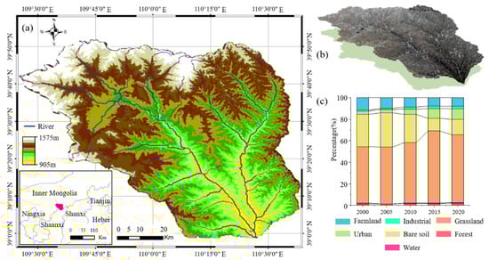
Figure 1.
(a) The location of the Ulan Mulun River Basin; (b) Landsat 8 remote sensing map with terrain; (c) Seven land-use types percentage in the Ulan Mulun River Basin from 2000 to 2020.

Table 1.
The proportion of land-use type area in Ulan Mulun River Basin for 2000, 2005, 2010, 2015, and 2020.
The southwestern region of the basin is the main farmland area. The water is mainly the Ulan Mulun River. Grassland and bare ground are scattered throughout the watershed. Four main land-use types [42] account for more than 85% of the watershed area: agricultural land; grassland; bare land; and towns.
The Ulan Mulun River Basin has various mineral resources, and it is also an important energy base in the Ordos [43]. The development of the energy and mining industries has stimulated the local economy and population growth, while increasing the demand for environmental resources [44]. These reasons have created the severe arid and water-deficient areas in the inland arid-semi-arid region of the Ulan Mulun River Basin. The basin’s economic area is also faced with severe problems such as ecological fragility, environmental pollution, and resource consumption. The balance between social economic growth and environmental protection has become an essential issue in this region [45]. Therefore, it is urgent to study the spatial and temporal distribution of ecological-environmental quality in the Ulan Mulun River Basin to provide a scientific basis for the sustainable development of future ecological security policy.
2.2. Data
Due to the different orbital periods of satellites, the remote sensing images used in this study in 2000, 2005, and 2010 were Landsat 5 TM [46], and the remote sensing images used in 2015 and 2020 were Landsat 8 OLI/TIRS [47]. The GEE platform contains atmospherically corrected surface reflectance and land surface temperature derived from the data produced by the Landsat 5 TM (USGS Landsat 5 Level 2, Collection 2, Tier 1) and Landsat 8 OLI/TIRS sensors (USGS Landsat 8 Level 2, Collection 2, Tier 1). All Collection 2 ST products are developed with a single-channel algorithm jointly created by the Rochester Institute of Technology (RIT) and the National Aeronautics and Space Administration (NASA) Jet Propulsion Laboratory (JPL). This method solves the problem of reflectivity differences between different data types [48]. The cloud cover of these remote sensing images is less than 5%, and the pixels with clouds in the images are processed by the cloud removal algorithm [49]. The GEE platform provides different cloud processing algorithms to avoid different types of Landsat. To avoid the uncertain impact of seasonal changes, we selected remote sensing images from June to October each year. During this time, the local vegetation was in the growth and development period. In this study, we mainly used the Google Earth Engine (GEE) platform [50] to specifically process satellite imagery and other earth observation data.
2.3. Methodology
RSEI is a remote sensing index that can make a rapid detection and assessment of the ecological environment [51]. RSEI takes into account the ecological environment’s affecting factors, which consist of four coupling components: green index; wetness; dryness; and heat [52]. Among the commonly used vegetation indices [53,54], the Normalized Difference Vegetation Index (NDVI) [55] can effectively reflect the vegetation physical characteristics, such as vegetation growth and vegetation coverage. It has been widely used in vegetation remote-sensing research. In this paper, we adopted the NDVI to represent the greenness index. Soil moisture plays an important role in the research and application of climate [56], environment, and ecology. Soil moisture level can reflect the regional ecological-environmental quality and is an important index for monitoring the surface environment [57]. In remote sensing technology, the tasseled cap transformation [58] can be used to invert soil moisture and effectively remove redundant data. We used the humidity component in the tasseled cap transformation [59] to represent the humidity index. The dryness index is one of the important indicators in ecological-environmental monitoring and evaluation. In general, the dryness index is constructed by the bare soil index (SI) [60] and building index (NDBI) [61]. The surface temperature represents the heat index, and the atmospheric correction method in the single-channel algorithm [62] is used to do the heat index inversion.
In Table 2, the values of the β1–6 in Landsat 5 TM are 0.0315, 0.2021, 0.3012, 0.1594, −0.6806, and −0.6109, respectively. K1 is 607.76 Wm−2 Sr−1 μm−1 and K2 = 1260.56 K. The β1–6 in Landsat 8 OLI/TIRS are 0.1511, 0.1973, 0.3283, 0.3407, −0.7117, and −0.4559, respectively. K1 = 774.89 Wm−2 Sr−1 μm−1 and K2 = 1321.08 K [63]. The above four remote-sensing indices were coupled by principal component analysis (PCA), as shown in Equation (1) [64]. RSEI is a principal component analysis based on covariance, so the influence of each index on RSEI depends on natural data, avoiding the influence of subjective factors [65]. The RSEI value is mainly calculated based on the first principal component:
RSEI = f (NDVI, WET, NDBSI, LST)
Table 2.
WET, NDVI, NDBSI and LST calculation formula, and explanation.
Before principal component analysis, it is necessary to perform normalization processing. In order to unify different dimension units, and to solve the comparability between different data indicators, on the GEE platform, we performed data normalization. Four indicators needed to be standardized within [0, 1]. PC 1 is calculated by the principal component analysis (PCA) algorithm [66]. PC 1 is RSEI0, and RSEI can be obtained by subtracting RSEI0 from 1 [63]. In order to quantitatively study the change of RSEI, the RSEI was divided into five grades at equal intervals: poor [0, 0.2]; fair [0.2, 0.4]; moderate [0.4, 0.6]; good [0.6, 0.8]; and excellent [0.8, 1] [67], based on existing research [68].
2.4. Transition Matrix Analysis
Transfer matrix analysis is an application of the Markov model. The Markov model [69] is a stochastic process analysis method with no after effects. The system is concerned with future and present states, while past states have less weight. The transfer matrix is a quantitative description of system state and state transition in system analysis, which can effectively analyze the transition of different levels of the RSEI [70]. In this study, remote sensing images were used to calculate the different levels of RSEI transfer process in the Ulan Mulun River Basin from 2000 to 2020. We made Circos tables to reflect the change between the two images. Circos is particularly suitable for layering different datasets to create highly informative graphics that are textured and visually appealing. The calculation process is shown in Table 3.
Table 3.
A sample of RSEI level transition matrix.
T1 and T2 were images of RSEI, respectively. Rows represent RSEI different level proportions at T1, and columns represent RSEI different level proportions at T2. Pij represents the percentage of RSEI different levels i converted to land type j in the total land area during T1–T2. Pii represents the percentage of area of I RSEI different level that remains unchanged during T1–T2. N is the grade of RSEI. We used the circlizeR package in the R language to draw Circos.
2.5. Spatial Auto-Correlation Analysis
The purpose of spatial auto-correlation analysis [71] is to determine whether a variable has spatially correlated. In the remote sensing field, it can indicate the correlation relationship between the ecological environment quality of the central pixel point and the adjacent space [72]. It described the spatial homogeneity distribution. The global spatial auto-correlation (Global Moran’s I) and local indicator of spatial association (Local Moran’s I) were employed to analyze the spatial correlation of RSEI [73].
The Global Moran’s I index describes the average correlation degree of all spatial units in an entire region with the surrounding region. The value of the attribute in the formula depends on the research objective [74]. In this study, the RSEI value is taken as the pixel attribute; it is shown in Equation (2):
In the formula, n is the total number of space units. Yi and yj represent the attribute values of the i-th space unit and the j-th space unit, respectively. is the mean value of the attribute values of all the space units, and Wij is the space weight value. The value range of I is [−1, 1]. I > 0 means that the ecological environment quality of all regions has a positive correlation. The larger the attribute value is, the easier it is to cluster together. I = 0 means the region is randomly distributed and has no spatial correlation. I < 0 means that the attribute values of all regions have negative correlation; that is, the larger the attribute values are, the less likely they are to be clustered together [75].
Local spatial auto-correlation can detect whether there is variable aggregation in local regions. This can further clarify the distribution of the ecological environment quality of the adjacent pixels, to make up for the global spatial auto-correlation deficiency that cannot determine the specific aggregation area. Hot spot analysis can further analyze the local spatial auto-correlation of the ecological environment [76]. The Local Moran′s I (LISA) Index calculation expression is as follows:
The parameter interpretation of Equation (3) is the same as that of Equation (2). There are 5 types of local spatial aggregation in the LISA cluster map: High-High (H-H); Low-Low (L-L); Low-High (L-H); High-Low (H-L); and Not Significant. H-H means that the sampling point location of ecological environment quality and the spatial adjacent area values are both high values. L-L means that the sampling point location of ecological environment quality and the spatial adjacent area values are both low. L-H means that the sampling point location of ecological environment quality is low, but the spatial adjacent area values are high. H-L means that the sampling point location of ecological environment quality is high, but the spatial adjacent area values are low [77].
2.6. Flow Chart
The detailed research workflow is shown in Figure 2. First, we preprocessed different remote-sensing data to calculate the values of LST, WET, NDBSI, and NDVI based on the GEE platform. Second, we calculated the RSEI for 2000, 2005, 2010, 2015, and 2020 based on the above four indices. Third, it analyzed the spatial and temporal distribution characteristics of the ecological-environmental quality in the Ulan Mulun River Basin. Finally, we studied the spatial correlation of the ecological-environmental quality in the Ulan Mulun River Basin.
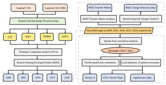
Figure 2.
Flow chart showing the ecological quality in the Ulan Mulun River Basin.
3. Results
3.1. RSEI Model Results
The results of the principal component analysis are shown in Table 4. In the percent eigenvalue results, the average value of the first principal component (PC 1) was 55.81%, the PC 2 was 30.16%, the PC 3 was 10.03%, and the PC 4 was 4%. It shows that the PC 1 indicator has more than half of the features of the four indicators. PC 1 shows an overall upward trend in 20 years. The eigenvalues of greenness (NDVI) and wetness (WET) in PC1 were positive indicating that greenness and wetness have positive effects on the RSEI [78]. The mean value of NDVI was 0.6069, and the mean value of WET was 0.4603. It can be concluded that the eigenvalue of greenness was greater than that of wetness [79]. NDVI had a maximum value of 0.8025 in 2005, while WET had a maximum value of 0.5272 in 2010. The eigenvalue of dryness (NDBSI) and heat (LST) were negative indicating that dryness and heat have negative effects on the RSEI. The mean value of LST was −0.3173, and the mean value of NDBSI was −0.4500. The eigenvalue of dryness was greater than that of heat.
Table 4.
Principal component analysis results of the RSEI for 2000, 2005, 2010, 2015, and 2020.
3.2. Spatiotemporal Changes in Eco-Environment Quality of Ulan Mulun River Basin
From the change in the indicators in Table 5, the mean values of the indicators of greenness (NDVI) and wetness (WET) were favorable to the ecology. The values showed a gradual increase during the study period, while the LST and NDBSI, which represent poor ecological conditions, decreased gradually. The statistical results of the four indices and RSEI in the Ulan Mulun River Basin are shown in Table 5. The average RSEI was 0.449 in 20 years, with an overall increase of 0.089, indicating that the ecological-environment quality was increasing. The increasing trend was 0.0006/a in 2000–2005, 0.0044/a in 2005–2010, 0.0026/a in 2010–2015, and 0.0102/a in 2015–2020. Overall, the growth rate of the RSEI index shows an upward trend. The above four indicators indicated that the ecological quality of the Ulan Mulun River Basin had an upward trend. The result of RSEI is consistent with it. It can be concluded that RSEI can comprehensively represent the four indicators [80]. RSEI can quantitatively describe the degree of ecological quality change, which is more advantageous than a single index analysis.
Table 5.
Statistics of four indicators and RSEI for 2000, 2005, 2010, 2015, and 2020.
3.3. RSEI Distribution in Ulan Mulun River Basin
Figure 3 shows the distribution of RSEI in the Mulan River Basin from 2000 to 2020. Yellow represents the poor area, red represents the fair area, cyan represents the moderate area, dark green represents the good area and blue represents the excellent area. On the whole, from 2000 to 2010, the fair and poor grades were mainly distributed in the central and western areas of the basin. These areas are located in low elevation areas with large populations and concentrated towns, such as Alteng Xire Town, Ulan Mulun Town, Ejin Horo Town, and Daliuta Town. The moderate and good areas were mainly distributed in the basin’s eastern areas, such as Zungarzhao Town, Narisong Town, and Nari Taohai Town, the basin’s northern areas such as Hantai Town, Tongchuan Town, and Dongsheng District, and the basin’s southern areas such as Sunjiacha Town, Daliuta Town, and Dachanghan Town. These areas had small urban regions, less industrial activity, and more intact native surfaces. The excellent grade RSEI in 2005 was mainly distributed in the southeast of the basin. In 2015 and 2020, the poor and fair grades showed a fragmentation trend. These areas were mainly in the central, northwestern, and eastern parts of the basin. The area of excellent grades decreased, while the areas of moderate and good grades in the middle of the watershed increased.
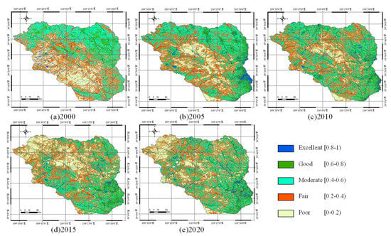
Figure 3.
Temporal and spatial distribution (a–e) of RSEI in the Mulan River Basin.
The results are shown in Figure 4. The proportion of the fair grade area was the highest, and the area was the largest in the Ulan Mulun River Basin. The fair grade area in 2020 was 2705 square kilometers and mainly transferred to the poor level and the moderate level. The proportion of moderate level was less than the fair level, and the proportion was in the second place. According to the Circos proportion, the area of the moderate level had decreased by 380 square kilometers in the past 20 years. Figure 4a shows that the moderate level changed drastically from 2000 to 2005, Figure 4b–d show that the transition area was stable in the remaining 15 years. Its main transition types were good and fair. Over the past 20 years, the area of excellent grade increased by 14 square kilometers, the smallest of the five categories, accounting for 3.1 percent. Between 2005 and 2020, there was no noticeable increase between the excellent grade transfer inward and transfer out, and the excellent grade in some areas mainly dropped to the good level.
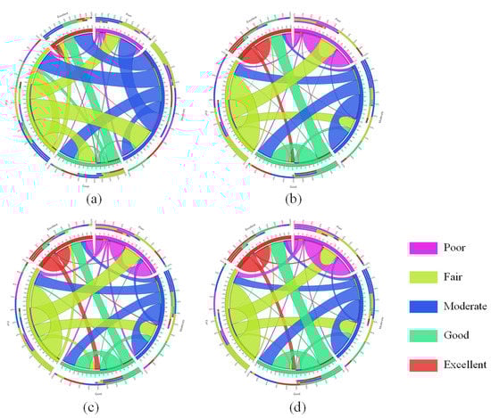
Figure 4.
The Ulan Mulun River Basin RSEI transfer matrix. (a) 2000–2005; (b) 2005–2010; (c) 2010–2015; (d) 2015–2020.
3.4. Ecological Environment Quality Change Distribution in the Ulan Mulun River Basin
The difference method was used to detect the variation region of RSEI in the Ulan Mulun River Basin. Figure 5 shows the results of environmental change. The increasing trend of ecological-environmental quality was gradually decreasing from deep red to light pink. In Figure 5, the RSEI index changed differently over the four stages. The change regions were divided into three grades according to Jenks’ best natural discontinuity method [81], which were deterioration [−1, −0.32], slight change [−0.32, 0.32], and improvement [0.32, 1]. From 2000 to 2020, the proportion of ecological-environmental quality in the improvement area showed a declining trend (Figure 5a: 37.28%; Figure 5b: 19.31%; Figure 5c 20.19%; Figure 5d: 15.81%). the deterioration area also showed a declining trend (Figure 5a: 41.7%; Figure 5b: 30.2%; Figure 5c: 19.72%; Figure 5d: 17.33%). The area of slight change gradually increased in the whole basin (Figure 5a: 21.02%; Figure 5b: 50.49%; Figure 5c: 60.09%; Figure 5d: 66.86%), indicating that the basin ecology was tending to develop steadily from rapid change. The RSEI recession area developed from the middle of the watershed to the edge of the watershed over 20 years. In the middle of the basin, such as Ulan Mulun Town and Nalin Taohai Town, it showed a trend of decline followed by growth. This indicated that the ecological-environment quality of the whole basin was gradually improving.
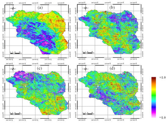
Figure 5.
RSEI change detection results in the Ulan Mulun River Basin from 2000 to 2020. (a) 2000–2005; (b) 2005–2010; (c) 2010–2015; (d) 2015–2020.
3.5. Significance of the RSEI Distribution in the Ulan Mulun River Basin
The sample points were classified according to the significance level (Figure 6). All three categories were represented, with dark green for the 5% significance, green for the 1% significance, and light green for the 0.1% significance. The cluster cores that passed the p = 0.001 significance test coincided with H-H and L-L regions. The sample points that passed the p = 0.001 significance test were mainly distributed in the central area of the watershed, and the rest were distributed in the marginal areas of the watershed. Our findings can be validated by land-use classification maps. From 2000 to 2020, the proportion of bare land had decreased from 30.05% to 14.42%, and the area of bare land had decreased by 459 square kilometers. The proportion of grassland [36,42] had increased from 52.17% to 62.89%, of which bare land was mainly converted into grassland.
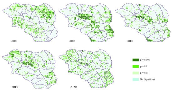
Figure 6.
Significance of the RSEI in Ulan Mulun River Basin in 2000, 2005, 2010, 2015, and 2020.
4. Discussion
4.1. Ecological Environment Quality Spatial Auto-Correlation Analysis
In order to ensure the integrity and consistency of information, it is necessary to enhance the accuracy and reliability of quantitative assessment in the study area. Based on the characteristics of landscape patterns and ecosystems, a 1 km × 1 km grid was used to resample the images [82]. In this paper, 6671 sample points were collected from each RSEI images and used to evaluate the relationship between geospatial space centroid value and other point values. This relationship was specifically measured using the spatial correlation coefficient and its degree.
Based on sample points divided by fishing nets, we conducted a spatial auto-correlation analysis of RSEI by Moran’s I index, LISA clustering map, and significance map. Figure 7 shows Moran’s I scatter diagram of RSEI. It could be seen that scatter points were mainly distributed in the first and third quadrants of the image, and less in the second and fourth quadrants. The upper-right quadrant and the lower-left quadrant correspond with positive spatial auto-correlation. It represented samples with similar values at neighboring locations. The Moran’s I indices were 0.455, 0.568, 0.374, 0.392, and 0.324 in 2000, 2005, 2010, 2015, and 2020, respectively. From 2000 to 2020, the Moran’s I index [83] fell by 0.131. It showed that the overall clustering of the spatial samples was declining in the Ulan Mulun River Basin.
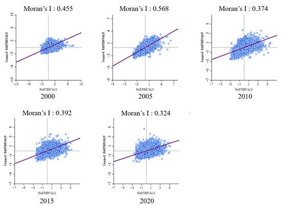
Figure 7.
Moran scatter plots of the RSEI in Ulan Mulun River Basin in 2000, 2005, 2010, 2015, and 2020.
LISA clustering maps enhance the sample significant locations based on the location of the value. Its spatial lag in the Moran scatter plot indicated the type of spatial association [84]. According to the LISA cluster map (Figure 8), all four categories were represented, with dark red for the high-high (H-H) clusters, dark blue for the low-low (L-L) clusters, light blue for the low-high (L-H) clusters, light red for the high-low (H-L) clusters, and yellow for not significant. In the Ulan Mulun River Basin, the main categories were H-H and L-L, while the H-L and L-H were less. In 2000, H-H was mainly distributed in the northeast of the basin: Hantai Town, Zhungeerzhao Town, Narisong Town and Nalin Taohai Town. In 2020, H-H was mainly distributed in Dachanghan Town and Dianta Town. H-H showed a changing trend from the northern part of the basin in 2000 to the southeastern part of the basin in 2020. The main reason for the reduction in the H-H area in the northwest of the basin was the large-scale urbanization expansion between 2000 and 2010. The quality of the fragile ecological environment was rapidly declining. The eastern part of the basin had complex terrain and few towns. The main reason for the change in H-H may be the inconsistent growth conditions of local vegetation [85]. The impact of rainfall may be the main driver. From 2005 to 2020, the L-L clustering area decreased continuously, reflecting that environmental protection measures have restrained the deterioration of environmental quality. In 2020, L-L was distributed in Suburga Town and Boerjiang Haizi Town and L-L was mainly located from the southwest to the northwest of the basin. The poor native environment and human activities have led to the formation of these L-L areas. Coal mines were dense in the central and southern parts of the basin, while the L-L area was reduced in 20 years, indicating the excellence of the ecological restoration project in the local mining area. The northwestern part of the basin is close to the Mu Us Desert. Large-scale ecological protection projects are being carried out in these areas [86]. The low-vegetation and no-vegetation areas in the basin are widely distributed, and the terrain is mostly denuded sand dunes and inter-dune grassland. The ecological environment here is fragile and easily affected by the natural environment. In arid and semi-arid regions, the intra-annual variation characteristics of vegetation index are consistent with the hydrothermal conditions. The difference in the distribution of H-H and L-L over the 20 year period is most likely the result of the uneven distribution of annual rainfall within the basin. The continuous development of the city will cause certain damage to the ecological environment around the city [87]. This is also the reason for the aggregation of the L-L region in the middle of the basin.
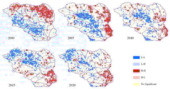
Figure 8.
LISA cluster map of the RSEI in Ulan Mulun River Basin in 2000, 2005, 2010, 2015, and 2020.
4.2. Strengths and Limitations
The novelty of this study is that we studied the temporal and spatial variation of the ecological-environmental quality in the Ulan Mulun River Basin from 2000 to 2020 based RSEI and GEE cloud platform. The GEE cloud platform has the advantages of high-performance processing and the computing of massive data. Compared with traditional remote-sensing image-processing tools, GEE can effectively solve the real-time and large-scale monitoring problems faced by RSEI [88]. Additionally, we investigated the spatial auto-correlation of RSEI in the Ulan Mulun River Basin.
From 2000 to 2020, the first, second, and tertiary industries of the economy of the Ulan Mulun River Basin had a significant improvement. The population also had obviously increased and the urbanization construction rapidly expanded. Some scholars believe that population growth will lead to a shortage of resources and aggravate environmental pollution [34]. According to the land-use data, from 2000 to 2020, the urban and industrial areas showed considerable development; the proportion of the whole basin area increased from 3.98% to 12%. These areas were mainly distributed along the Ulan Mulun River valley. At the same time, the local government was actively promoting environmental protection measures [89], such as desertification control and returning farmland to forests. In addition to the increase in the grassland area, the farmland area of the whole basin decreased to 8.06% of the basin area in 2020. From the perspective of area proportion, 71.46% of the total area was green vegetation in 2020 while 60.58% of the total area was green vegetation in 2000. Vegetation was the main ecological impact factor in the Ulan Mulun River Basin [90]. The increase in the area of green plants showed the positive development of the local ecological environment [75]. This is consistent with the finding in Table 4 that NDVI made the largest contribution. Land use management and climatic conditions may be the main reasons for the reduced clustering degree. Most of the bare land in the basin had been ecologically restored, forming many local vegetation coverage areas. It appeared as highly fragmented grassland in remote sensing images. Although the clustering degree was reduced by Moran’s I values, the ecological environment of the basin had been improved. The climatic conditions were also developing towards the trend of adapting to the growth of vegetation. Deng et al. considered that the correlation coefficient between the area of vegetation coverage and precipitation was very high [1]. According to meteorological data, the annual precipitation was 276 mm (2000), 251 mm (2005), 387.5 mm (2010), 384 mm (2015), and 456 mm (2020), respectively. Precipitation had increased from 251 mm in 2000 to 456 mm in 2020. The average annual rainfall increased by 10.25 mm. The annual average temperatures were 7.2 °C (2000), 6.9 °C (2005), 7.5 °C (2010), 7.9 °C (2015), and 8.1 °C (2020), respectively. The annual average temperature shows an increasing trend. The Ulan Mulun River Basin is dominated by industry, with less animal husbandry, and grazing management is not the main reason for the impact. The major driver is land-use management. Local land-management methods are conducive to ecological restoration. This is also consistent with the performance of the basin’s RSEI, indicating the superiority of RSEI in reflecting [91] the changing trend in ecological-environmental quality. However, as Xia et al. argued, the RSEI only takes into account greenness, humidity, heat, and dryness [92]. This is not comprehensive for a complex and changing ecosystem. Therefore, future research will combine more spatial data and socio-economic data, such as primary net productivity data, land-use data, and surface evapotranspiration data, etc.
4.3. Policy Implications
In the implementation of macro-ecological management policies, there is a policy lag, which leads to the loss of ecological-environmental quality management information [93]. Therefore, cities and towns lack freedom and initiative, which is not conducive to the coordinated and sustainable development of the watershed. At the same time, this can damage plant and animal habitats [94], with adverse effects on biodiversity. RSEI can make recommendations from a macro perspective. It can cooperate with local governments or departments to organize, coordinate, lead, and control the management objects or affairs within the territory according to the actual local conditions and with ecological interests at the center [95], in order to achieve the protection of ecological diversity and of biological diversity. In addition, we selected some sub-watersheds for field surveys to further study the changes in field ecology. This may be helpful for future research on the mechanism of ecological change [96] in the Ulan Mulun River Basin. It mainly includes spectral information collection of ground objects, vegetation data survey [97], and low-altitude remote-sensing of unmanned aerial vehicles, etc. This is helpful for an accurate assessment of the ecological environment in small areas. Local governments can implement refined and targeted measures for ecological protection.
5. Conclusions
In this paper, we evaluated the Ulan Mulun River Basin ecological-environmental quality and its temporal and spatial changes over the past 20 years (2000, 2005, 2010, 2015, 2020) based on RSEI. All Landsat 5/8 data were based on the GEE platform. The result of this paper showed that the mean value of RSEI in the past 20 years was between 0.4 and 0.6 (0.418, 0.421, 0.443, 0.456, 0.507). From a macro point of view, the ecological-environmental quality of the basin was moderate and the ecological situation improved gradually. The distribution characteristics of RSEI were high in the surrounding area and low in the central area. The area of deterioration decreased by 24.37% and slight change increased by 45.84%. The Moran’s I values in 2000, 2005, 2010, 2015, and 2020 were 0.455, 0.568, 0.374, 0.392, and 0.324, respectively. It showed that the Ulan Mulun River Basin ecological-environmental quality spatial distribution presented a positive correlation, with clustering characteristics and low randomness. The degree of spatial clustering first increased and then decreased. H-H were mainly distributed in the eastern and southern regions of the basin, where the proportion of urbanization was low and the ecological environment was better. L-L was mainly distributed in the central and western regions of the basin with intensive social activities and industrial regions.
Author Contributions
Conceptualization, M.L. and S.Z.; methodology, M.L.; formal analysis, Z.L.; investigation, S.Z.; writing—original draft preparation, M.L.; writing—review and editing, R.L.; supervision, X.L. and L.Y.; project administration, S.Z.; funding acquisition, S.Z. and L.H. All authors have read and agreed to the published version of the manuscript.
Funding
This research was funded by the National Key Research and Development Program of China (Grant number 2021YFC3201201); National Natural Science Foundation of China, under grant of 52079063; Technological Achievements of Inner Mongolia Autonomous Region of China (Grant no. 2020CG0054 and 2020GG0076); Natural Science Foundation of Inner Mongolia Autonomous Region of China (Grant no. 2019JQ06 and 2021MS04013).
Institutional Review Board Statement
Not applicable.
Informed Consent Statement
Not applicable.
Data Availability Statement
The data presented in this study are available on reasonable from the corresponding author.
Acknowledgments
We thank the anonymous reviewers for their constructive feedback.
Conflicts of Interest
The authors declare no conflict of interest.
References
- Jones, B.M.; Grosse, G.; Farquharson, L.M.; Roy-Léveillée, P.; Veremeeva, A.; Kanevskiy, M.Z.; Gaglioti, B.V.; Breen, A.L.; Parsekian, A.D.; Ulrich, M.; et al. Lake and drained lake basin systems in lowland permafrost regions. Nat. Rev. Earth Environ. 2022, 3, 85–98. [Google Scholar] [CrossRef]
- Ostrom, E. A General Framework for Analyzing Sustainability of Social-Ecological Systems. Science 2009, 325, 419–422. [Google Scholar] [CrossRef] [PubMed]
- Feizizadeh, B.; Lakes, T.; Omarzadeh, D.; Sharifi, A.; Blaschke, T.; Karimzadeh, S. Scenario-based analysis of the impacts of lake drying on food production in the Lake Urmia Basin of Northern Iran. Sci. Rep. 2022, 12, 6237. [Google Scholar] [CrossRef] [PubMed]
- Wang, Z.; Li, J.; Liang, L. Ecological risk in the Tibetan Plateau and influencing urbanization factors. Environ. Challenges 2022, 6, 100445. [Google Scholar] [CrossRef]
- Sun, X.; Zhang, H.; Ahmad, M.; Xue, C. Analysis of influencing factors of carbon emissions in resource-based cities in the Yellow River basin under carbon neutrality target. Environ. Sci. Pollut. Res. 2021, 29, 23847–23860. [Google Scholar] [CrossRef] [PubMed]
- Wang, Q.; Wang, N.; Wang, H.; Xiu, Y. Study on Influencing Factors and Simulation of Watershed Ecological Compensation Based on Evolutionary Game. Sustainability 2022, 14, 3374. [Google Scholar] [CrossRef]
- Luo, P.; Xu, C.; Kang, S.; Huo, A.; Lyu, J.; Zhou, M.; Nover, D. Heavy metals in water and surface sediments of the Fenghe River Basin, China: Assessment and source analysis. Water Sci. Technol. 2021, 84, 3072–3090. [Google Scholar] [CrossRef]
- Zhang, Y.; Luo, P.; Zhao, S.; Kang, S.; Wang, P.; Zhou, M.; Lyu, J. Control and remediation methods for eutrophic lakes in recent 30 years. Water Sci. Technol. 2020, 81, 1099–1113. [Google Scholar] [CrossRef]
- Zhang, X.; Liu, K.; Wang, S.; Wu, T.; Li, X.; Wang, J.; Wang, D.; Zhu, H.; Tan, C.; Ji, Y. Spatiotemporal evolution of ecological vulnerability in the Yellow River Basin under ecological restoration initiatives. Ecol. Indic. 2022, 135, 108586. [Google Scholar] [CrossRef]
- Xiao, Y.; Guo, B.; Lu, Y.; Zhang, R.; Zhang, D.; Zhen, X.; Chen, S.; Wu, H.; Wei, C.; Yang, L.; et al. Spatial–temporal evolution patterns of soil erosion in the Yellow River Basin from 1990 to 2015: Impacts of natural factors and land use change. Geomat. Nat. Hazards Risk 2021, 12, 103–122. [Google Scholar] [CrossRef]
- Cavender-Bares, J.; Schneider, F.D.; Santos, M.J.; Armstrong, A.; Carnaval, A.; Dahlin, K.M.; Fatoyinbo, L.; Hurtt, G.C.; Schimel, D.; Townsend, P.A.; et al. Integrating remote sensing with ecology and evolution to advance biodiversity conservation. Nat. Ecol. Evol. 2022, 6, 506–519. [Google Scholar] [CrossRef] [PubMed]
- Liao, W.; Jiang, W.; Huang, Z. Spatiotemporal variations of eco-environment in the Guangxi Beibu Gulf Economic Zone based on remote sensing ecological index and granular computing. J. Geogr. Sci. 2022, 32, 1813–1830. [Google Scholar] [CrossRef]
- Guo, B.; Yang, F.; Fan, J.; Lu, Y. The Changes of Spatiotemporal Pattern of Rocky Desertification and Its Dominant Driving Factors in Typical Karst Mountainous Areas under the Background of Global Change. Remote Sens. 2022, 14, 2351. [Google Scholar] [CrossRef]
- Guo, B.; Wei, C.; Yu, Y.; Liu, Y.; Li, J.; Meng, C.; Cai, Y. The dominant influencing factors of desertification changes in the source region of Yellow River: Climate change or human activity? Sci. Total Environ. 2021, 813, 152512. [Google Scholar] [CrossRef]
- Liao, W.; Nie, X.; Zhang, Z. Interval association of remote sensing ecological index in China based on concept lattice. Environ. Sci. Pollut. Res. 2022, 29, 34194–34208. [Google Scholar] [CrossRef] [PubMed]
- Xie, Z.; Zhu, W.; He, B.; Qiao, K.; Zhan, P.; Huang, X. A background-free phenology index for improved monitoring of vegetation phenology. Agric. For. Meteorol. 2022, 315, 108826. [Google Scholar] [CrossRef]
- Aboelsoud, H.M.; AbdelRahman, M.A.E.; Kheir, A.M.S.; Eid, M.S.M.; Ammar, K.A.; Khalifa, T.H.; Scopa, A. Quantitative Estimation of Saline-Soil Amelioration Using Remote-Sensing Indices in Arid Land for Better Management. Land 2022, 11, 1041. [Google Scholar] [CrossRef]
- Huang, S.; Tang, L.; Hupy, J.P.; Wang, Y.; Shao, G.F. A commentary review on the use of normalized difference vegetation index (NDVI) in the era of popular remote sensing. J. For. Res. 2021, 32, 1–6. [Google Scholar] [CrossRef]
- Kumari, N.; Srivastava, A.; Dumka, U. A Long-Term Spatiotemporal Analysis of Vegetation Greenness over the Himalayan Region Using Google Earth Engine. Climate 2021, 9, 109. [Google Scholar] [CrossRef]
- Sun, G.; Jiao, Z.; Zhang, A.; Li, F.; Fu, H.; Li, Z. Hyperspectral image-based vegetation index (HSVI): A new vegetation index for urban ecological research. Int. J. Appl. earth Obs. Geoinf. ITC J. 2021, 103, 102529. [Google Scholar] [CrossRef]
- Cilek, M.U.; Cilek, A. Analyses of land surface temperature (LST) variability among local climate zones (LCZs) comparing Landsat-8 and ENVI-met model data. Sustain. Cities Soc. 2021, 69, 102877. [Google Scholar] [CrossRef]
- Mondol, A.H.; Zhu, X.; Dunkerley, D.; Henley, B.J. Observed meteorological drought trends in Bangladesh identified with the Effective Drought Index (EDI). Agric. Water Manag. 2021, 255, 107001. [Google Scholar] [CrossRef]
- Yaseen, Z.M.; Ali, M.; Sharafati, A.; Al-Ansari, N.; Shahid, S. Forecasting standardized precipitation index using data intelligence models: Regional investigation of Bangladesh. Sci. Rep. 2021, 11, 3435. [Google Scholar] [CrossRef]
- Deyle, E.R.; Bouffard, D.; Frossard, V.; Schwefel, R.; Melack, J.; Sugihara, G. A hybrid empirical and parametric approach for managing ecosystem complexity: Water quality in Lake Geneva under nonstationary futures. Proc. Natl. Acad. Sci. USA 2022, 119, e2102466119. [Google Scholar] [CrossRef]
- Shojaei, S.; Rahimzadegan, M. Improving a comprehensive remote sensing drought index (CRSDI) in the Western part of Iran. Geocarto Int. 2020, 37, 1318–1336. [Google Scholar] [CrossRef]
- Binding, C.; Pizzolato, L.; Zeng, C. EOLakeWatch; delivering a comprehensive suite of remote sensing algal bloom indices for enhanced monitoring of Canadian eutrophic lakes. Ecol. Indic. 2020, 121, 106999. [Google Scholar] [CrossRef]
- Wu, H.; Guo, B.; Fan, J.; Yang, F.; Han, B.; Wei, C.; Lu, Y.; Zang, W.; Zhen, X.; Meng, C. A novel remote sensing ecological vulnerability index on large scale: A case study of the China-Pakistan Economic Corridor region. Ecol. Indic. 2021, 129, 107955. [Google Scholar] [CrossRef]
- Xu, H.Q. A Remote Sensing Index for Assessment of Regional Ecological Changes. China Environ. Sci. 2013, 33, 889–897. [Google Scholar]
- Ren, W.; Zhang, X.; Peng, H. Evaluation of Temporal and Spatial Changes in Ecological Environmental Quality on Jianghan Plain From 1990 to 2021. Front. Environ. Sci. 2022, 10, 77. [Google Scholar] [CrossRef]
- Zhang, Y.; Song, T.; Fan, J.; Man, W.; Liu, M.; Zhao, Y.; Zheng, H.; Liu, Y.; Li, C.; Song, J.; et al. Land Use and Climate Change Altered the Ecological Quality in the Luanhe River Basin. Int. J. Environ. Res. Public Health 2022, 19, 7719. [Google Scholar] [CrossRef]
- Hou, J.; Rusuli, Y. Assessment of Soil Salinization Risk by Remote Sensing-Based Ecological Index (RSEI) in the Bosten Lake Watershed, Xinjiang in Northwest China. Sustainability 2022, 14, 7118. [Google Scholar] [CrossRef]
- Jiang, C.L.; Wu, L.; Liu, D.; Wang, S.M. Dynamic monitoring of eco-environmental quality in arid desert area by remote sensing: Taking the Gurbantunggut Desert China as an example. J. Appl. Ecol. 2019, 30, 877–883. [Google Scholar]
- Shan, W.; Jin, X.; Ren, J.; Wang, Y.; Xu, Z.; Fan, Y.; Gu, Z.; Hong, C.; Lin, J.; Zhou, Y. Ecological environment quality assessment based on remote sensing data for land consolidation. J. Clean. Prod. 2019, 239, 118126. [Google Scholar] [CrossRef]
- An, M.; Xie, P.; He, W.; Wang, B.; Huang, J.; Khanal, R. Spatiotemporal change of ecologic environment quality and human interaction factors in three gorges ecologic economic corridor, based on RSEI. Ecol. Indic. 2022, 141, 109090. [Google Scholar] [CrossRef]
- Yang, Y.; Yang, D.; Wang, X.; Zhang, Z.; Nawaz, Z. Testing Accuracy of Land Cover Classification Algorithms in the Qilian Mountains Based on GEE Cloud Platform. Remote Sens. 2021, 13, 5064. [Google Scholar] [CrossRef]
- Gorelick, N.; Hancher, M.; Dixon, M.; Ilyushchenko, S.; Thau, D.; Moore, R. Google Earth Engine: Planetary-scale geospatial analysis for everyone. Remote Sens. Environ. 2017, 202, 18–27. [Google Scholar] [CrossRef]
- Rajandran, A.; Tan, M.L.; Samat, N.; Chan, N.W. A review of Google Earth Engine application in mapping aquaculture ponds. In IOP Conference Series: Earth and Environmental Science; IOP Publishing: Bristol, UK, 2022; Volume 1064, p. 012011. [Google Scholar]
- Halder, B.; Bandyopadhyay, J. Monitoring the tropical cyclone ‘Yass’ and ‘Amphan’affected flood inundation using Sentinel-1/2 data and Google Earth Engine. Model. Earth Syst. Environ. 2022, 8, 4317–4332. [Google Scholar] [CrossRef]
- Zhang, W.; Jin, Z.; Liu, Q.; Shan, X.; Li, P.; Liang, X. The C–S–Fe system evolution reveals organic matter preservation in lacustrine shales of Yanchang Formation, Ordos Basin, China. Mar. Pet. Geol. 2022, 142, 105734. [Google Scholar] [CrossRef]
- Zhang, Z.; Li, G.; Su, X.; Zhuang, X.; Wang, L.; Fu, H.; Li, L. Geochemical controls on the enrichment of fluoride in the mine water of the Shendong mining area, China. Chemosphere 2021, 284, 131388. [Google Scholar] [CrossRef] [PubMed]
- Xiao, W.; Zhang, W.; Ye, Y.; Lv, X.; Yang, W. Is underground coal mining causing land degradation and significantly damaging ecosystems in semi-arid areas? A study from an Ecological Capital perspective. Land Degrad. Dev. 2020, 31, 1969–1989. [Google Scholar] [CrossRef]
- Guo, Y.; Li, R.; Chen, J.; Chen, G.; Li, B. Driving Analysis of Spatiotemporal Change of Land Use in Production-Living-Ecology Space in Shendong Mining Area. Int. J. Front. Eng. Technol. 2020, 2, 213–221. [Google Scholar] [CrossRef]
- Zeng, Y.; Lian, H.; Du, X.; Tan, X.; Liu, D. An Analog Model Study on Water–Sand Mixture Inrush Mechanisms During the Mining of Shallow Coal Seams. Mine Water Environ. 2022, 41, 428–436. [Google Scholar] [CrossRef]
- Zhang, Y.; Khan, I.; Zafar, M.W. Assessing environmental quality through natural resources, energy resources, and tax revenues. Environ. Sci. Pollut. Res. 2022, 7, 1–16. [Google Scholar] [CrossRef] [PubMed]
- Yang, X.; Yao, W.; Li, P.; Hu, J.; Latifi, H.; Kang, L.; Wang, N.; Zhang, D. Changes of SOC Content in China’s Shendong Coal Mining Area during 1990–2020 Investigated Using Remote Sensing Techniques. Sustainability 2022, 14, 7374. [Google Scholar] [CrossRef]
- Ambinakudige, S.; Intsiful, A. Estimation of area and volume change in the glaciers of the Columbia Icefield, Canada using machine learning algorithms and Landsat images. Remote Sens. Appl. Soc. Environ. 2022, 26, 100732. [Google Scholar] [CrossRef]
- Kosczor, E.; Forkel, M.; Hernández, J.; Kinalczyk, D.; Pirotti, F.; Kutchartt, E. Assessing land surface phenology in Araucaria-Nothofagus forests in Chile with Landsat 8/Sentinel-2 time series. Int. J. Appl. Earth Obs. Geoinf. 2022, 112, 102862. [Google Scholar] [CrossRef]
- Xia, X.; Jiao, C.; Song, S.; Zhang, L.; Feng, X.; Huang, Q. Developing a method for assessing environmental sustainability based on the Google Earth Engine platform. Environ. Sci. Pollut. Res. 2022, 29, 57437–57452. [Google Scholar] [CrossRef]
- Cao, R.; Xu, Z.; Chen, Y.; Chen, J.; Shen, M. Reconstructing High-Spatiotemporal-Resolution (30 m and 8-Days) NDVI Time-Series Data for the Qinghai–Tibetan Plateau from 2000–2020. Remote Sens. 2022, 14, 3648. [Google Scholar] [CrossRef]
- Gxokwe, S.; Dube, T.; Mazvimavi, D. Leveraging Google Earth Engine platform to characterize and map small seasonal wetlands in the semi-arid environments of South Africa. Sci. Total Environ. 2021, 803, 150139. [Google Scholar] [CrossRef]
- Hu, X.; Xu, H. A new remote sensing index for assessing the spatial heterogeneity in urban ecological quality: A case from Fuzhou City, China. Ecol. Indic. 2018, 89, 11–21. [Google Scholar] [CrossRef]
- Lu, X.; Peng, S.; Yin, Y. Evaluation of Ecological Environment in Futuanhe Nature Reserve Based on Remote Sensing Ecological Index. In Proceedings of the 2022 IEEE 6th Information Technology and Mechatronics Engineering Conference (ITOEC), Chongqing, China, 4–6 March 2022; Volume 6, pp. 1351–1354. [Google Scholar]
- Zeng, Y.; Hao, D.; Huete, A.; Dechant, B.; Berry, J.; Chen, J.M.; Joiner, J.; Frankenberg, C.; Bond-Lamberty, B.; Chen, M.; et al. Optical vegetation indices for monitoring terrestrial ecosystems globally. Nat. Rev. Earth Environ. 2022, 3, 477–493. [Google Scholar] [CrossRef]
- Ferchichi, A.; Ben Abbes, A.; Barra, V.; Farah, I.R. Forecasting vegetation indices from spatio-temporal remotely sensed data using deep learning-based approaches: A systematic literature review. Ecol. Informatics 2022, 68, 101552. [Google Scholar] [CrossRef]
- Sams, B.; Bramley, R.G.; Sanchez, L.; Dokoozlian, N.; Ford, C.; Pagay, V. Remote Sensing, Yield, Physical Characteristics, and Fruit Composition Variability in Cabernet Sauvignon Vineyards. Am. J. Enol. Vitic. 2022, 73, 93–105. [Google Scholar] [CrossRef]
- Cheng, M.; Jiao, X.; Liu, Y.; Shao, M.; Yu, X.; Bai, Y.; Wang, Z.; Wang, S.; Tuohuti, N.; Liu, S.; et al. Estimation of soil moisture content under high maize canopy coverage from UAV multimodal data and machine learning. Agric. Water Manag. 2022, 264, 107530. [Google Scholar] [CrossRef]
- Schlüter, S.; Leuther, F.; Albrecht, L.; Hoeschen, C.; Kilian, R.; Surey, R.; Mikutta, R.; Kaiser, K.; Mueller, C.W.; Vogel, H.-J. Microscale carbon distribution around pores and particulate organic matter varies with soil moisture regime. Nat. Commun. 2022, 13, 2098. [Google Scholar] [CrossRef] [PubMed]
- Chen, C.; Chen, H.; Liang, J.; Huang, W.; Xu, W.; Li, B.; Wang, J. Extraction of Water Body Information from Remote Sensing Imagery While Considering Greenness and Wetness Based on Tasseled Cap Transformation. Remote Sens. 2022, 14, 3001. [Google Scholar] [CrossRef]
- Luo, H.; Ming, D.; Xu, L. Time series calculation of remote sensing ecological index based on GEE. Remote Sens. Nat. Resour. 2022, 34, 271–277. [Google Scholar]
- Awad, M.; Aldaood, A.; Alkiki, I. Development of a Compressibility Prediction Model Based on Soil Index Properties and Area Under/Bounded by Consolidation and Rebound Curves. Geotech. Geol. Eng. 2022, 40, 4787–4807. [Google Scholar] [CrossRef]
- Permatasari, A.D.; Prasetyo, S.Y.J. Identifikasi Wilayah Resiko Kerusakan Lahan Terbangun Sebagai Dampak Tsunami Berdasarkan Analisis Building Indices. J. Transform. 2022, 20, 13–21. [Google Scholar] [CrossRef]
- Yang, J.; Duan, S.-B.; Zhang, X.; Wu, P.; Huang, C.; Leng, P.; Gao, M. Evaluation of Seven Atmospheric Profiles from Reanalysis and Satellite-Derived Products: Implication for Single-Channel Land Surface Temperature Retrieval. Remote Sens. 2020, 12, 791. [Google Scholar] [CrossRef]
- Gao, W.; Zhang, S.; Rao, X.; Lin, X.; Li, R. Landsat TM/OLI-Based Ecological and Environmental Quality Survey of Yellow River Basin, Inner Mongolia Section. Remote Sens. 2021, 13, 4477. [Google Scholar] [CrossRef]
- Chen, Z.; Chen, J.; Zhou, C.; Li, Y. An ecological assessment process based on integrated remote sensing model: A case from Kaikukang-Walagan District, Greater Khingan Range, China. Ecol. Inform. 2022, 70, 101699. [Google Scholar] [CrossRef]
- Seddon, A.W.R.; Macias-Fauria, M.; Long, P.R.; Benz, D.; Willis, K.J. Sensitivity of global terrestrial ecosystems to climate variability. Nature 2016, 531, 229–232. [Google Scholar] [CrossRef] [PubMed]
- Boori, M.S.; Choudhary, K.; Paringer, R.; Kupriyanov, A. Eco-environmental quality assessment based on pressure-state-response framework by remote sensing and GIS. Remote Sens. Appl. Soc. Environ. 2021, 23, 100530. [Google Scholar] [CrossRef]
- Zhou, J.; Liu, W. Monitoring and Evaluation of Eco-Environment Quality Based on Remote Sensing-Based Ecological Index (RSEI) in Taihu Lake Basin, China. Sustainability 2022, 14, 5642. [Google Scholar] [CrossRef]
- Wen, X.; Ming, Y.; Gao, Y.; Hu, X. Dynamic Monitoring and Analysis of Ecological Quality of Pingtan Comprehensive Experimental Zone, a New Type of Sea Island City, Based on RSEI. Sustainability 2019, 12, 21. [Google Scholar] [CrossRef]
- Visser, I.; Speekenbrink, M. Hidden Markov Models. In Mixture and Hidden Markov Models with R; Springer: Cham, Switzerland, 2022; pp. 125–172. [Google Scholar]
- Zhou, Z.; Feng, Q.; Zhu, C.; Luo, W.; Wang, L.; Zhao, X.; Zhang, L. The Spatial and Temporal Evolution of Ecological Environment Quality in Karst Ecologically Fragile Areas Driven by Poverty Alleviation Resettlement. Land 2022, 11, 1150. [Google Scholar] [CrossRef]
- Le, K.G.; Liu, P.; Lin, L.-T. Traffic accident hotspot identification by integrating kernel density estimation and spatial autocorrelation analysis: A case study. Int. J. Crashworthiness 2020, 27, 543–553. [Google Scholar] [CrossRef]
- Hu, X.; Ma, C.; Huang, P.; Guo, X. Ecological vulnerability assessment based on AHP-PSR method and analysis of its single parameter sensitivity and spatial autocorrelation for ecological protection—A case of Weifang City, China. Ecol. Indic. 2021, 125, 107464. [Google Scholar] [CrossRef]
- Jing, Y.; Zhang, F.; He, Y.; Kung, H.-T.; Johnson, V.C.; Arikena, M. Assessment of spatial and temporal variation of ecological environment quality in Ebinur Lake Wetland National Nature Reserve, Xinjiang, China. Ecol. Indic. 2019, 110, 105874. [Google Scholar] [CrossRef]
- Fangfeng, L.; Jieping, C.; Zicen, L. Comprehensive Evaluation and Analysis of Spatial Dynamic Transition of Air Pollution. In IOP Conference Series: Earth and Environmental Science; IOP Publishing: Bristol, UK, 2021; Volume 676, p. 012009. [Google Scholar]
- Hou, R.; Li, S.; Chen, H.; Ren, G.; Gao, W.; Liu, L. Coupling mechanism and development prospect of innovative ecosystem of clean energy in smart agriculture based on blockchain. J. Clean. Prod. 2021, 319, 128466. [Google Scholar] [CrossRef]
- Coca, O.; Ricaurte-Villota, C. Regional Patterns of Coastal Erosion and Sedimentation Derived from Spatial Autocorrelation Analysis: Pacific and Colombian Caribbean. Coasts 2022, 2, 125–151. [Google Scholar] [CrossRef]
- Boudou, M.; Cleary, E.; ÓhAiseadha, C.; Garvey, P.; McKeown, P.; O’Dwyer, J.; Hynds, P. Spatiotemporal epidemiology of cryptosporidiosis in the Republic of Ireland, 2008–2017: Development of a space–time “cluster recurrence” index. BMC Infect. Dis. 2021, 21, 880. [Google Scholar] [CrossRef] [PubMed]
- Cui, R.; Han, J.; Hu, Z. Assessment of Spatial Temporal Changes of Ecological Environment Quality: A Case Study in Huaibei City, China. Land 2022, 11, 944. [Google Scholar] [CrossRef]
- Lian, Z.; Hao, H.; Zhao, J.; Cao, K.; Wang, H.; He, Z. Evaluation of Remote Sensing Ecological Index Based on Soil and Water Conservation on the Effectiveness of Management of Abandoned Mine Landscaping Transformation. Int. J. Environ. Res. Public Health 2022, 19, 9750. [Google Scholar] [CrossRef] [PubMed]
- Ye, H. Analysis on Ecological Environment Change of Kalajun-Kurdening World Natural Heritage Site from 2006 to 2019. Pol. J. Environ. Stud. 2021, 31, 915–927. [Google Scholar] [CrossRef]
- Liu, J.; Xin, Z.; Huang, Y.; Yu, J. Climate suitability assessment on the Qinghai-Tibet Plateau. Sci. Total Environ. 2021, 816, 151653. [Google Scholar] [CrossRef]
- Xiong, Y.; Xu, W.; Lu, N.; Huang, S.; Wu, C.; Wang, L.; Dai, F.; Kou, W. Assessment of spatial–temporal changes of ecological environment quality based on RSEI and GEE: A case study in Erhai Lake Basin, Yunnan province, China. Ecol. Indic. 2021, 125, 107518. [Google Scholar] [CrossRef]
- Kassouri, Y.; Okunlola, O.A. Analysis of spatio-temporal drivers and convergence characteristics of urban development in Africa. Land Use Policy 2021, 112, 105868. [Google Scholar] [CrossRef]
- Anselin, L. A Local Indicator of Multivariate Spatial Association: Extending Geary’s c. Geogr. Anal. 2019, 51, 133–150. [Google Scholar] [CrossRef]
- Li, Y.Q.; Chen, Y.; Cao, W.J.; Wang, X.Y.; Niu, Y.Y. Theoretical basis of ecology for the influence of global change on resources, environment, and ecosystems. Ying Yong Sheng Tai Xue Bao J. Appl. Ecol. 2022, 33, 603–612. [Google Scholar]
- Feng, J.; Wang, N.; Sun, G. Measurement of Innovation-Driven Development Performance of Large-Scale Environmental Protection Enterprises Investing in Public–Private Partnership Projects Based on the Hybrid Method. Sustainability 2022, 14, 5096. [Google Scholar] [CrossRef]
- Zhao, L.; Shen, Y.; Gu, N.; Dai, J. Development Mode of Recreation Belt around the City: Ecological Authenticity or Fashion Creativity? Bioinorg. Chem. Appl. 2022, 2022, 9292668. [Google Scholar] [CrossRef] [PubMed]
- Wang, M. Land Classification in Chang Tang Nature Reserve Supported by GEE Cloud Platform. World Sci. Res. J. 2022, 8, 548–554. [Google Scholar]
- Shuning, D. Patterns of Rational Development and Utilization of Water Resources in the Study Area. In Study on the Optimal Allocation of Water Resources Systems and the Comprehensive Utilization of Water Resources in Arid-Semiarid Multiple Mining Areas; Springer: Cham, Switzerland, 2016; pp. 219–242. [Google Scholar]
- Shi, L.; Yang, L. Study on treatment technology of industrial and mining wasteland in Shenmu City. In IOP Conference Series: Earth and Environmental Science; IOP Publishing: Bristol, UK, 2021; Volume 804, p. 042011. [Google Scholar]
- Sun, C.; Li, X.; Zhang, W.; Li, X. Evolution of ecological security in the tableland region of the Chinese loess plateau using a remote-sensing-based index. Sustainability 2020, 12, 3489. [Google Scholar] [CrossRef]
- Xia, Q.-Q.; Chen, Y.-N.; Zhang, X.-Q.; Ding, J.-L. Spatiotemporal Changes in Ecological Quality and Its Associated Driving Factors in Central Asia. Remote Sens. 2022, 14, 3500. [Google Scholar] [CrossRef]
- Norberg, J.; Blenckner, T.; Cornell, S.E.; Petchey, O.L.; Hillebrand, H. Failures to disagree are essential for environmental science to effectively influence policy development. Ecol. Lett. 2022, 25, 1075–1093. [Google Scholar] [CrossRef]
- Vakhitov, D.R.; Uryadnikova, M.V.; Nashirvanova, Y.F.; Makarova, E.S.; Kirillova, L.G. Environmental aspects of the industrial policy of modern municipalities. In Cooperation and Sustainable Development; Springer: Cham, Switzerland, 2022; pp. 1387–1393. [Google Scholar]
- Ding, W.; Jimoh, S.O.; Hou, X.; Shu, X.; Dong, H.; Bolormaa, D.; Wang, D. Grassland Ecological Subsidy Policy and Livestock Reduction Behavior: A Case Study of Herdsmen in Northern China. Rangel. Ecol. Manag. 2022, 81, 78–85. [Google Scholar] [CrossRef]
- Awan, U. Industrial ecology in support of sustainable development goals. In Responsible Consumption and Production; Springer International Publishing: Cham, Switzerland, 2022; pp. 370–380. [Google Scholar]
- Liu, S.; Shao, Q.; Ning, J.; Niu, L.; Zhang, X.; Liu, G.; Huang, H. Remote-Sensing-Based Assessment of the Ecological Restoration Degree and Restoration Potential of Ecosystems in the Upper Yellow River over the Past 20 Years. Remote Sens. 2022, 14, 3550. [Google Scholar] [CrossRef]
Publisher’s Note: MDPI stays neutral with regard to jurisdictional claims in published maps and institutional affiliations. |
© 2022 by the authors. Licensee MDPI, Basel, Switzerland. This article is an open access article distributed under the terms and conditions of the Creative Commons Attribution (CC BY) license (https://creativecommons.org/licenses/by/4.0/).