
Disaster Risk Assessment of Informal Settlements in the Global South


Abstract
1. Introduction
2. Materials and Methods
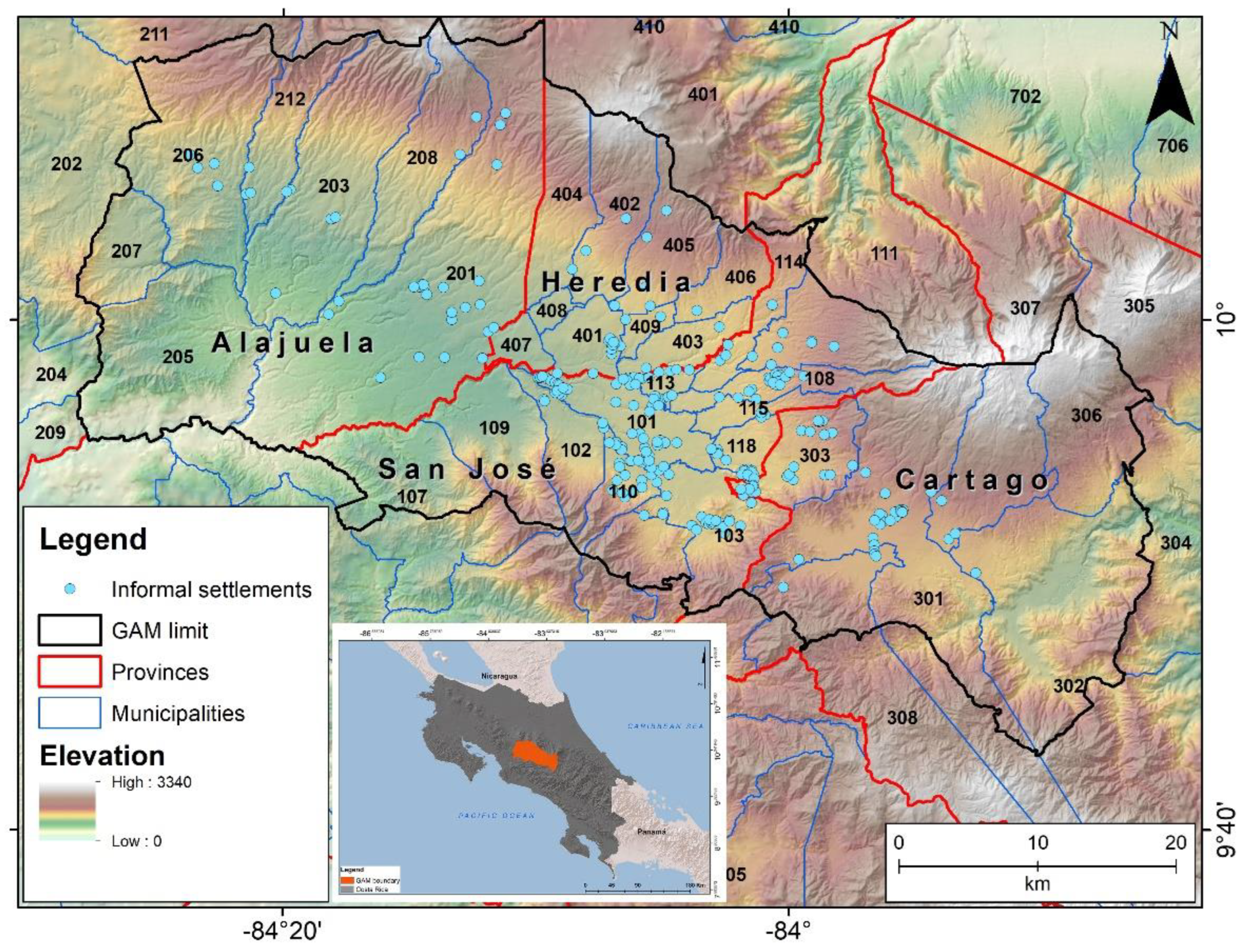
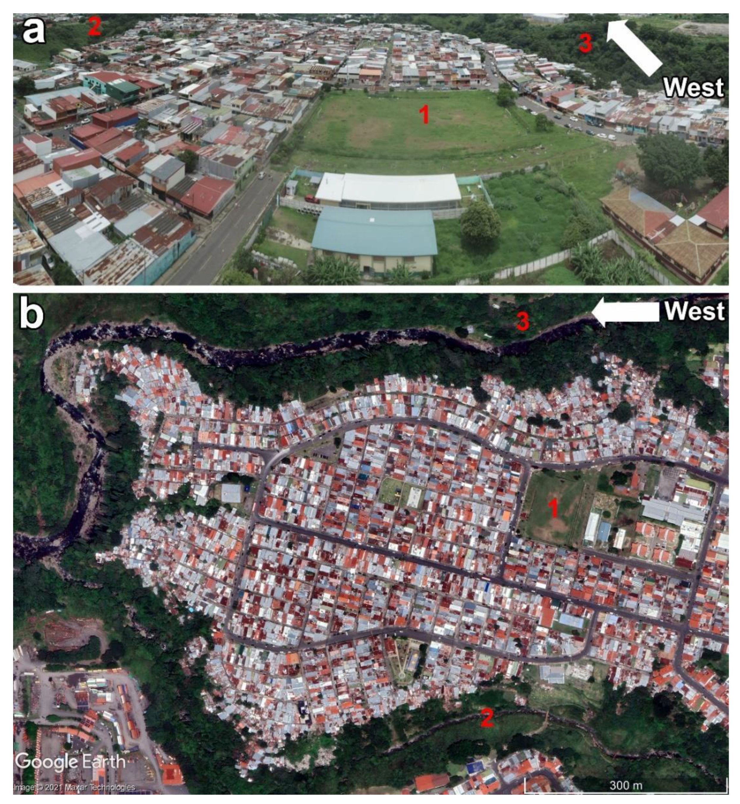
2.1. Costa Rica and the GAM’s Geographical Setting
2.2. Informal Settlements Risk Determination
3. Results and Discussion
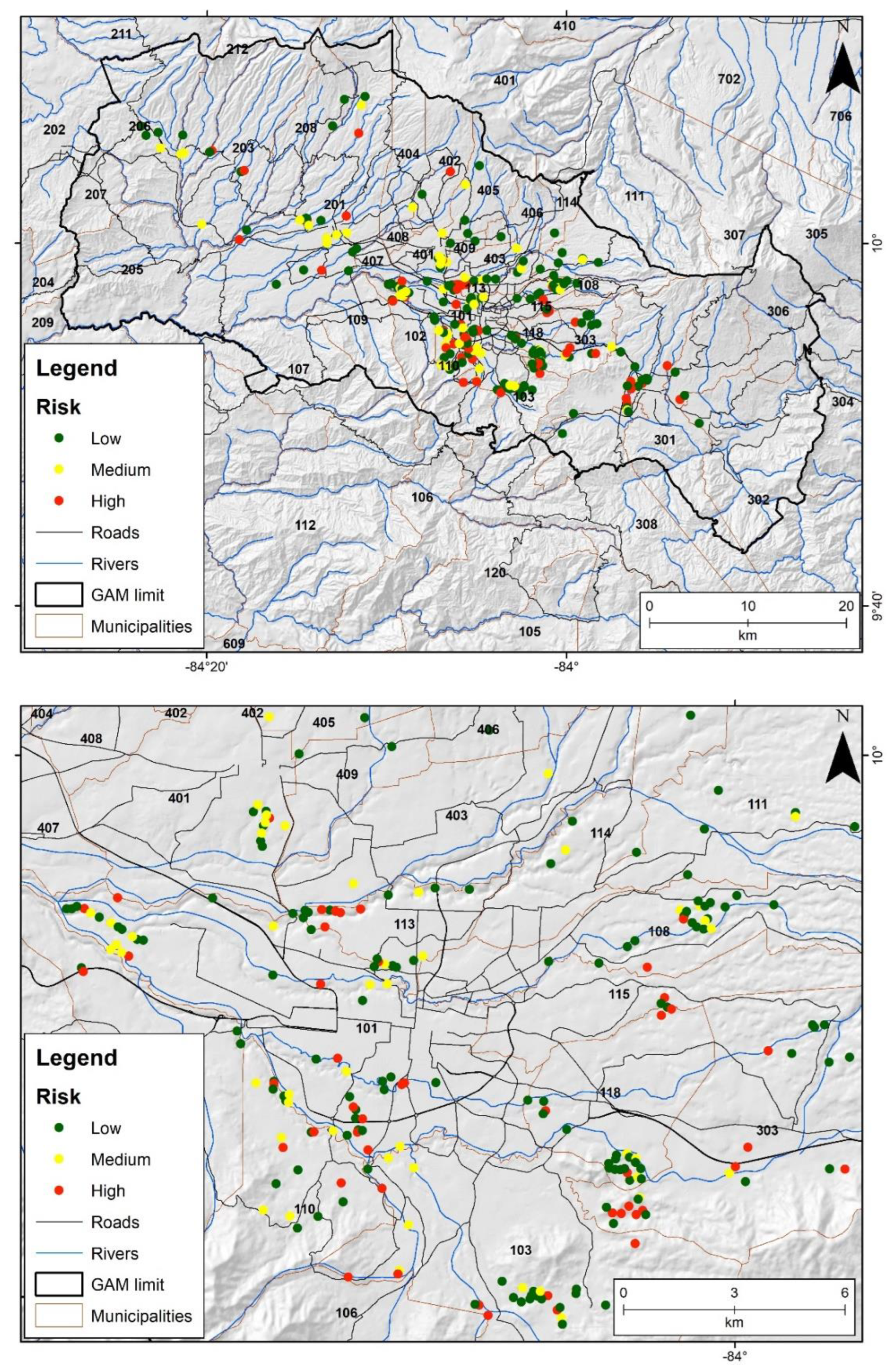
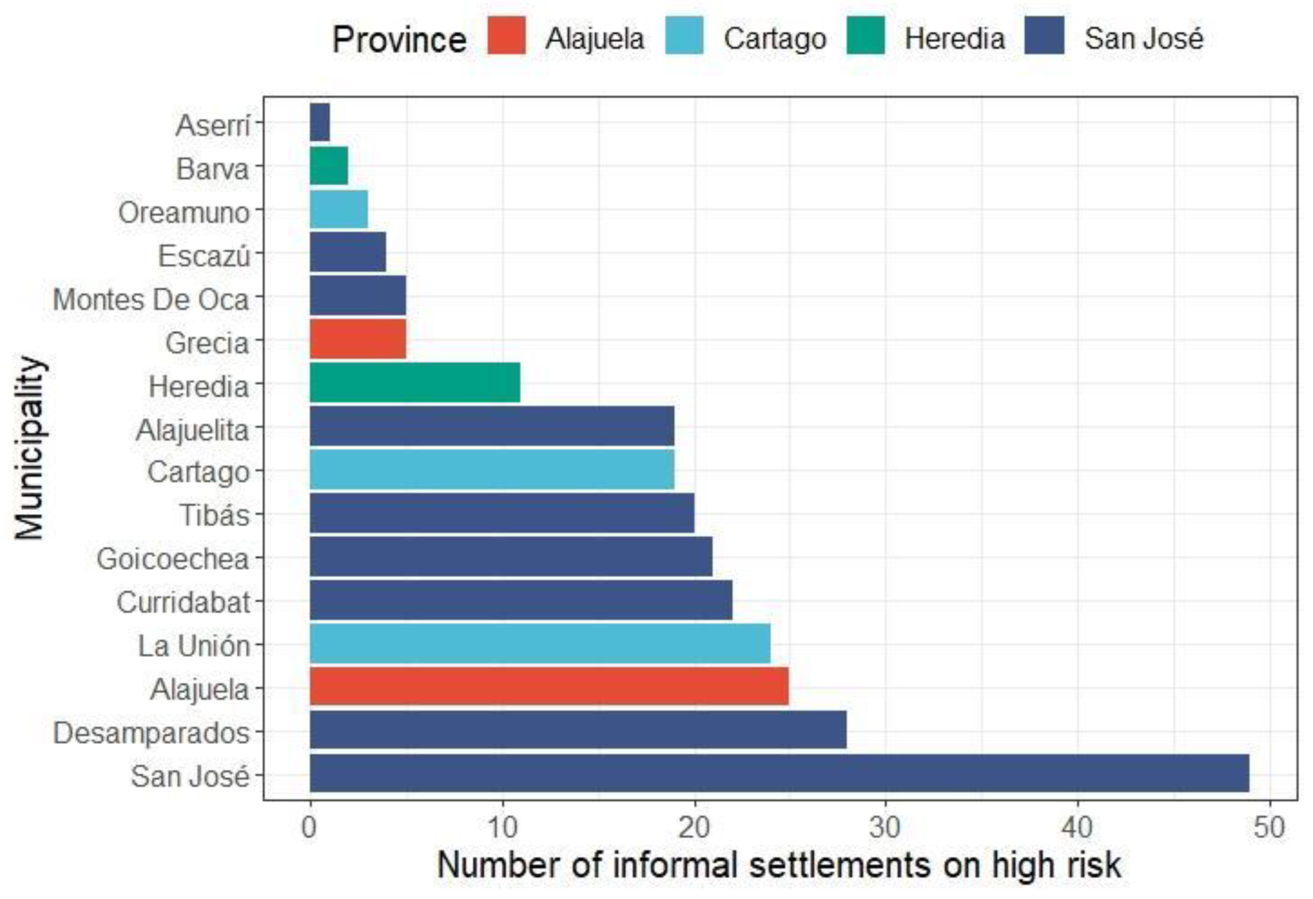
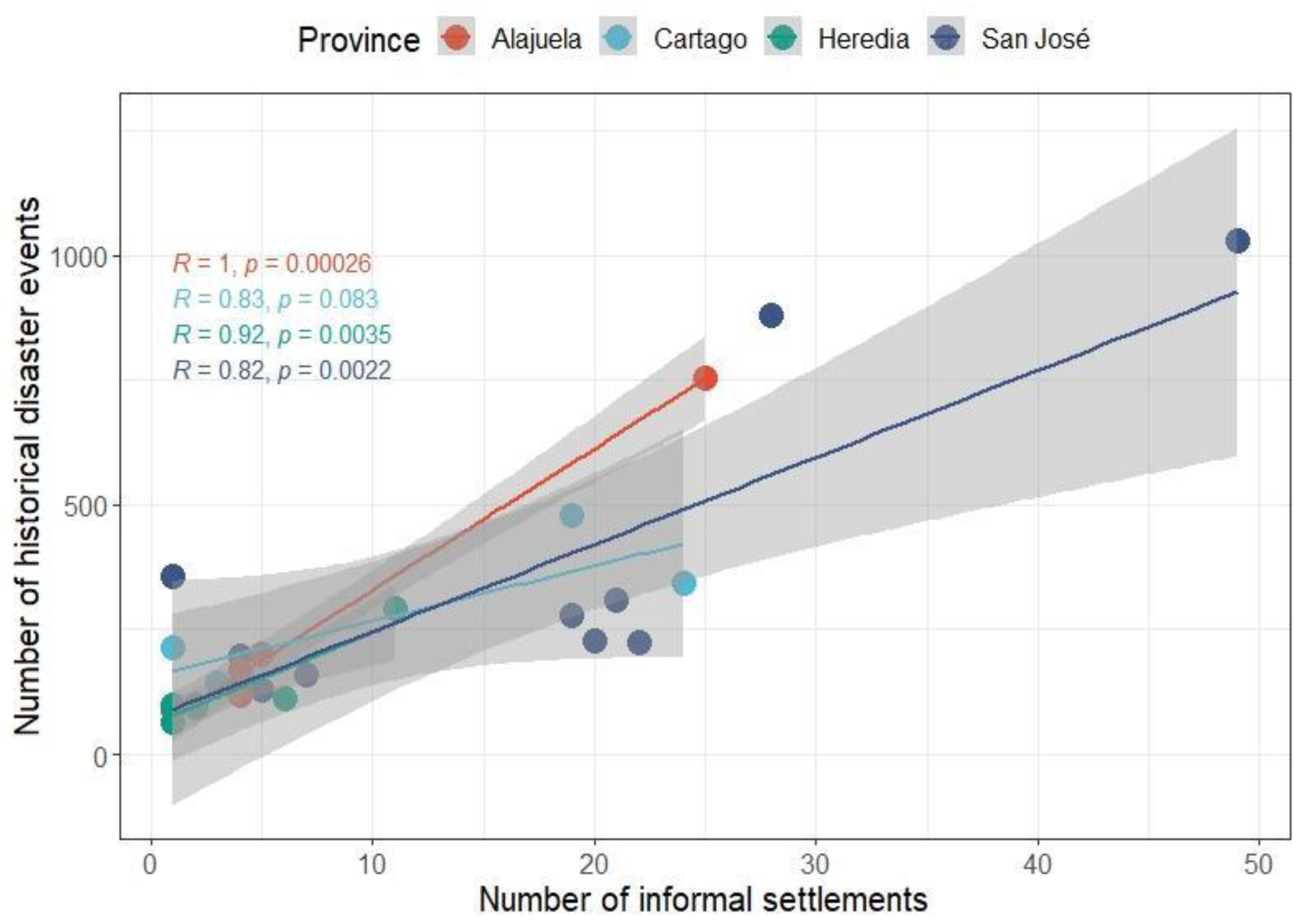
3.1. Risk of the GAM’s Informal Settlements
3.2. Policy Implications
4. Conclusions
Supplementary Materials
Funding
Institutional Review Board Statement
Informed Consent Statement
Data Availability Statement
Acknowledgments
Conflicts of Interest
References
- Soman, S.; Beukes, A.; Nederhood, C.; Marchio, N.; Bettencourt, L. Worldwide detection of informal settlements via topological analysis of crowdsourced digital maps. ISPRS 2020, 9, 685. [Google Scholar]
- United Nations Human Settlements Programme (UN-Habitat). Indicator 11.1.1: Proportion of Urban Population Living in Slums, Informal Settlements or Inadequate Housing. 2021. Available online: https://unstats.un.org/sdgs/metadata/files/Metadata-11-01-01.pdf (accessed on 7 January 2021).
- Dovey, K. Sustainable informal settlements? Procedia Soc. 2015, 179, 5–13. [Google Scholar] [CrossRef]
- Dovey, K.; van Oostrum, M.; Chatterjee, I.; Shafique, T. Towards a morphogenesis of informal settlements. Habitat Int. 2020, 104, 102240. [Google Scholar] [CrossRef]
- Avis, W.R. Urban Governance (Topic Guide); GSDRC, University of Birmingham: Birmingham, UK, 2016. [Google Scholar]
- Adnan, S.G.; Kreibich, H. An evaluation of disaster risk reduction (DRR) approaches for coastal delta cities: A comparative analysis. Nat. Hazards 2016, 83, 1257–1278. [Google Scholar] [CrossRef]
- Kamalipour, H.; Dovey, K. Mapping the visibility of informal settlements. Habitat Int. 2019, 85, 63–75. [Google Scholar] [CrossRef]
- UN-Habitat. The challenge of slums: Global report on human settlements 2003. Manag. Environ. Qual. Int. J. 2004, 15, 337–338. [Google Scholar] [CrossRef]
- Ross, A.G.; Zaman, K.; Clemens, J.D. Health concerns in urban slums: A glimpse of things to come? JAMA 2019, 321, 1973–1974. [Google Scholar] [CrossRef]
- Doberstein, B.; Stager, H. Towards guidelines for post-disaster vulnerability reduction in informal settlements. Disasters 2013, 37, 28–47. [Google Scholar] [CrossRef]
- Fernandes, E. Regularization of Informal Settlements in Latin America; Lincoln Institute of Land Policy: Cambridge, UK, 2011. [Google Scholar]
- Gunasekera, R.; Ishizawa, O.; Aubrecht, C.; Blankespoor, B.; Murray, S.; Pomonis, A.; Daniell, J. Developing an adaptive global exposure model to support the generation of country disaster risk profiles. Earth-Sci. Rev. 2015, 150, 594–608. [Google Scholar] [CrossRef]
- Arrieta, A.; Sarmiento, J.P.; Chabba, M.; Chen, W. Valuing disaster risk reduction neighborhood interventions in informal settlements of Latin American and the Caribbean. PLoS ONE 2020, 15, e0242409. [Google Scholar] [CrossRef] [PubMed]
- Montoya, J.; Cartes, I.; Zumelzu, A. Indicators for evaluating sustainability in Bogota’s informal settlements: Definition and validation. Sustain. Cities Soc. 2020, 53, 101896. [Google Scholar] [CrossRef]
- Miles, S.B.; Green, R.A.; Svekla, W. Disaster risk reduction capacity assessment for precarious settlements in Guatemala City. Disasters 2012, 36, 365–381. [Google Scholar] [CrossRef] [PubMed]
- Sandoval, V.; Sarmiento, J.P. A neglected issue: Informal settlements, urban development, and disaster risk reduction in Latin America and the Caribbean. Disaster Prev. Manag. 2020, 29, 731–745. [Google Scholar] [CrossRef]
- Carrión-Mero, P.; Montalván-Burbano, N.; Morante-Carballo, F.; Quesada-Román, A.; Apolo-Masache, B. Worldwide research trends in landslide science. Int. J. Environ. Res. Public Health 2021, 18, 9445. [Google Scholar] [CrossRef]
- Pinos, J.; Quesada-Román, A. Flood Risk-Related Research Trends in Latin America and the Caribbean. Water 2022, 14, 10. [Google Scholar] [CrossRef]
- Shi, P.; Kasperson, R. World Atlas of Natural Disaster Risk; Springer: Berlin/Heidelberg, Germany, 2015. [Google Scholar]
- Quesada-Román, A.; Campos-Durán, D. Natural disaster risk inequalities in Central America. Pap. Appl. Geogr. 2022, 1–15. [Google Scholar] [CrossRef]
- Abunyewah, M.; Gajendran, T.; Maund, K. Profiling informal settlements for disaster risks. Procedia Eng. 2018, 212, 238–245. [Google Scholar] [CrossRef]
- De Risi, R.; Jalayer, F.; De Paola, F.; Iervolino, I.; Giugni, M.; Topa, M.E.; Mbuya, E.; Kyessi, A.; Manfredi, G.; Gasparini, P. Flood risk assessment for informal settlements. Nat. Hazards 2013, 69, 1003–1032. [Google Scholar] [CrossRef]
- Flores-Quiroz, N.; Walls, R.; Cicione, A. Towards understanding fire causes in informal settlements based on inhabitant risk perception. Fire 2021, 4, 39. [Google Scholar] [CrossRef]
- Rush, D.; Bankoff, G.; Cooper-Knock, S.J.; Gibson, L.; Hirst, L.; Jordan, S.; Spinardi, G.; Twigg, J.; Walls, R.S. Fire risk reduction on the margins of an urbanizing world. Disaster Prev. Manag. 2020, 29, 747–760. [Google Scholar] [CrossRef]
- Williams, D.S.; Máñez Costa, M.; Celliers, L.; Sutherland, C. Informal settlements and flooding: Identifying strengths and weaknesses in local governance for water management. Water 2018, 10, 871. [Google Scholar] [CrossRef]
- Hofmann, P.; Taubenböck, H.; Werthmann, C. Monitoring and modelling of informal settlements-A review on recent developments and challenges. In Proceedings of the Joint Urban Remote Sensing 2015, Lausanne, Switzerland, 30 March–1 April 2015; pp. 1–4. [Google Scholar]
- Guillén-Montero, D.; Núñez-Román, O.A.; Vargas-Bogantes, J.; Vega-Ramírez, L.M. Situación de los Sistemas de Información Territorial para la gestión municipal: Caso de la GAM, Costa Rica, 2018. Rev. Geogr. América Cent. 2021, 59–78. [Google Scholar] [CrossRef]
- Liberoff, J.; Saborío, R. Informe de Actualización de la Base de Datos de Asentamientos en Condición de Precario y Tugurio de Costa Rica, al Año 2012; Ministerio de Vivienda y Asentamientos Humanos (MIVAH): San José, Costa Rica, 2012. [Google Scholar]
- Mora-Steiner, S. Hogares en asentamientos informales en Costa Rica: Quiénes son y cómo viven. Notas Población 2014, 99, 107–132. [Google Scholar] [CrossRef][Green Version]
- Alvarado, G.E.; Benito, B.; Staller, A.; Climent, A.; Camacho, E.; Rojas, W.; Marroquín, G.; Molina, E.; Talavera, J.E.; Martínez-Cuevas, S.; et al. The new Central American seismic hazard zonation: Mutual consensus based on up to day seismotectonic framework. Tectonophysics 2017, 721, 462–476. [Google Scholar] [CrossRef]
- Quesada-Román, A. Implicaciones en la Gestión del Riesgo de Desastres y Ambiente en el Valle Central en Los Últimos Treinta Años (1985–2015). Vigesimoprimer Informe Estado de la Nación en Desarrollo Humano Sostenible. 2015. Available online: https://repositorio.conare.ac.cr/handle/20.500.12337/617?show=full (accessed on 10 August 2022).
- La Red. DesInventar: Inventory System of the Effects of Disasters; Corporación OSSA: Cali, Colombia, 2022; Available online: http://desinventar.org (accessed on 22 April 2022).
- Marshall, J. The Geomorphology and Physiographic Provinces of Central America. In Central America: Geology, Resources and Hazards; Bundschuh, J., Alvarado, G.E., Eds.; Taylor & Francis: Abingdon, UK, 2007; p. 1436. [Google Scholar]
- Van Lidth de Jeude, M.; Schütte, O.; Quesada, F. The vicious circle of social segregation and spatial fragmentation in Costa Rica’s greater metropolitan area. Habitat Int. 2016, 54, 65–73. [Google Scholar] [CrossRef]
- Quesada-Román, A. Landslides and floods zonation using geomorphological analyses in a dynamic catchment of Costa Rica. Rev. Cart. 2021, 102, 125–138. [Google Scholar]
- SNIT—Sistema Nacional de Información Territorial. Official Spatial Databases of Costa Rica; Instituto Geográfico Nacional: San José, Costa Rica, 2022.
- Acosta-Schnell, S. Expansão Urbana em San José, Costa Rica: Da Formação da Metrópole à Verticalização. Master’s Thesis, Universidad Federal de Santa Catarina, Florianópolis, Brazil, 2014. [Google Scholar]
- Acosta-Schnell, S. Miniciudades: ¿Nuevas Formas Urbanas en San José (Costa Rica) y Ciudad Guatemala (Guatemala)? Ph.D. Thesis, Instituto de Altos Estudios de América Latina (IHEAL), Centre de Recherche et de Documentation des Amériques (CREDA), Unidad de Investigación 7227, Université Sorbonne Nouvelle Paris 3, Paris, France, 2020. [Google Scholar]
- Quesada-Román, A. Landslide risk index map at the municipal scale for Costa Rica. Int. J. Disaster Risk Reduct. 2021, 56, 102144. [Google Scholar] [CrossRef]
- MIVAH—Ministerio de Vivienda y Asentamientos Humanos. Distribución Geográfica de los Asentamientos Informales; MIVAH—Ministerio de Vivienda y Asentamientos Humanos: San José, Costa Rica, 2021.
- MIDEPLAN—Ministerio de Planificación Nacional y Política Económica. Índice de Desarrollo Social 2017; MIDEPLAN: San José, Costa Rica, 2017; p. 126.
- Fantin, R.; Santamaría-Ulloa, C.; Barboza-Solís, C. Socioeconomic inequalities in cancer mortality: Is Costa Rica an exception to the rule? Int. J. Cancer Res. 2020, 147, 1286–1293. [Google Scholar] [CrossRef]
- Gimenez, G.; Martín-Oro, A.; Sanaú, J. The effect of districts’ social development on student performance. Stud. Educ. Eval. 2018, 58, 80–96. [Google Scholar] [CrossRef]
- Quesada-Román, A. Flood risk index development at the municipal level in Costa Rica: A methodological framework. Environ. Sci. Policy 2022, 133, 98–106. [Google Scholar] [CrossRef]
- Vinod, H.D. Generalized correlation and kernel causality with applications in development economics. Commun. Stat.-Simul. Comput. 2017, 46, 4513–4534. [Google Scholar] [CrossRef]
- Krivoruchko, K. Spatial Statistical Data Analysis for GIS Users; Esri Press: Redlands, CA, USA, 2011; 938p. [Google Scholar]
- Sarmiento, J.P.; Hoberman, G.; Ilcheva, M.; Asgary, A.; Majano, A.M.; Poggione, S.; Duran, L.R. Private sector and disaster risk reduction: The cases of Bogota, Miami, Kingston, San José, Santiago, and Vancouver. Int. J. Disaster Risk Reduct. 2015, 14, 225–237. [Google Scholar] [CrossRef]
- Sandoval, V.; Sarmiento, J.P. Una mirada desde la gobernanza del riesgo y la resiliencia urbana en América Latina y el Caribe: Los asentamientos informales en la Nueva Agenda Urbana. REDER 2018, 2, 38–52. [Google Scholar] [CrossRef]
- Granados-Bolaños, S.; Quesada-Román, A.; Alvarado, G. Low-cost UAV applications in dynamic tropical volcanic landforms. J. Volcanol. Geotherm. Res. 2021, 410, 107143. [Google Scholar] [CrossRef]
- Quesada-Román, A.; Villalobos-Portilla, E.; Campos-Durán, D. Hydrometeorological disasters in urban areas of Costa Rica, Central America. Environ. Hazards 2021, 20, 264–278. [Google Scholar] [CrossRef]
- Quesada-Román, A.; Castro-Chacón, J.P.; Feoli-Boraschi, S. Geomorphology, land use, and environmental impacts in a densely populated urban catchment of Costa Rica. J. S. Am. Earth Sci. 2021, 112, 103560. [Google Scholar] [CrossRef]
- Orozco-Montoya, R.A.; Brenes-Maykall, A.; Sura-Fonseca, R. Inventario Histórico de Desastres en Costa Rica en el Periodo 1970–2020. REDER 2022, 6, 66–82. [Google Scholar] [CrossRef]
- Van Lidt de Jeude, M.; Schütte, O. El Círculo Vicioso de la Fragmentación Espacial y Segregación Social en la Gran Área Metropolitana de Costa Rica. REVISTARQUIS 2013, 2, 24–43. [Google Scholar]
- Blanco-Ramos, R.A. Los del sur de la ciudad capital: Control social y estigmatización en los barrios del sur de San José, 1950–1980. Diálogos Rev. Electrónica Hist. 2015, 16, 59–82. [Google Scholar] [CrossRef][Green Version]
- Esquivel-Hernández, G.; Sánchez-Murillo, R.; Birkel, C.; Boll, J. Climate and water conflicts coevolution from tropical development and hydro-climatic perspectives: A case study of Costa Rica. JAWRA 2018, 54, 451–470. [Google Scholar] [CrossRef]
- Gómez, G.P.; García, V.A.; Rodríguez, J.A.R.; Herrera, F.; Gutiérrez, R.S. Calidad fisicoquímica y microbiológica del agua superficial del río Grande de Tárcoles, Costa Rica: Un enfoque ecológico. UNED Res. J. 2021, 13, e3148. [Google Scholar]
- Mena-Rivera, L.; Vásquez-Bolaños, O.; Gómez-Castro, C.; Fonseca-Sánchez, A.; Rodríguez-Rodríguez, A.; Sánchez-Gutiérrez, R. Ecosystemic assessment of surface water quality in the Virilla river: Towards sanitation processes in Costa Rica. Water 2018, 10, 845. [Google Scholar] [CrossRef]
- Campos-Saborío, N.; Núñez-Rivas, H.P.; Holst-Schumacher, I.; Alfaro-Mora, F.V.; Chacón-Ruiz, B. Psychosocial and sociocultural characteristics of Nicaraguan and Costa Rican students in the context of intercultural education in Costa Rica. Intercult. Educ. 2018, 29, 450–469. [Google Scholar] [CrossRef]
- Montenegro, M. Costa Rica’s educational scenario in times of COVID-19 pandemic. Educ. Media Int. 2021, 58, 202–208. [Google Scholar] [CrossRef]
- Aboal, D.; Lanzilotta, B.; Dominguez, M.; Vairo, M. The cost of crime and violence in five Latin American countries. Eur. J. Crim. Policy Res. 2016, 22, 689–711. [Google Scholar] [CrossRef]
- Barrantes-Castillo, G.; Quesada-Román, A.; Campos-Durán, D.; Padilla-Umaña, K. Indicador de afectación por eventos naturales en el cantón de Alajuela, y su relación con la vulnerabilidad comunal. Rev. Geogr. América Cent. 2017, 3, 159–196. [Google Scholar] [CrossRef]
- Quesada-Román, A.; Calderón-Ramírez, G. Gestión del riesgo y política pública en el cantón de Desamparados, Costa Rica. Uniciencia 2018, 32, 1–19. [Google Scholar] [CrossRef]
- Rodríguez-Campos, J.; Fernández-Arce, M. Hazards Analysis in the Canton La Unión, Cartago, Costa Rica. Eur. J. Environ. Sci. 2021, 2, 30–34. [Google Scholar]
- Quesada-Román, A.; Zamorano-Orozco, J.J. Zonificación de procesos de ladera e inundaciones a partir de un análisis morfométrico en la cuenca alta del río General, Costa Rica. Inv. Geog. 2019, e59843. [Google Scholar] [CrossRef]
- Acosta-Schnell, S. Estrategias de venta del mercado inmobiliario costarricense: La naturaleza como mercadería. Rev. Ciência Trop. 2017, 41, 55–75. [Google Scholar]
- Pérez, M. Avatares del Ordenamiento Territorial en Costa Rica, 1st ed.; FLACSO: San José, Costa Rica, 2012. [Google Scholar]
- Acosta-Schnell, S. As recentes tendências no mercado imobiliário costarriquenho. Rev. Geo UERJ 2016, 28, 1–25. [Google Scholar]
- Acosta-Schnell, S. Os agentes produtores do espaço urbano nas recentes tendências do mercado imobiliário costarriquenho. Rev. GeoUSP 2016, 32, 88–96. [Google Scholar]
- Sánchez, L. Tendencias y patrones del crecimiento urbano en la GAM, implicaciones sociales, económicas y ambientales y desafíos desde el Ordenamiento territorial. In Informe Estado de la Nación en Desarrollo Humano Sostenible; CONARE, Programa Estado de la Nación: Pavas, Costa Rica, 2018; pp. 1–74. [Google Scholar]
- Acosta-Schnell, S. A transição para o capitalismo na Costa Rica: Uma colônia hispânica seduzida pelo grão de ouro. Rev. Formação 2013, 20, 78–93. [Google Scholar]
- Acosta-Schnell, S. Análise teórica para desvendar o lento aceite da recente verticalização residencial em San José, Costa Rica. Rev. URBE 2018, 10, 677–694. [Google Scholar] [CrossRef]
- Seidler, R.; Dietrich, K.; Schweizer, S.; Bawa, K.S.; Chopde, S.; Zaman, F.; Sharma, A.; Bhattacharya, S.; Devkota, L.P.; Khaling, S. Progress on integrating climate change adaptation and disaster risk reduction for sustainable development pathways in South Asia: Evidence from six research projects. Int. J. Disaster Risk Reduct. 2018, 31, 92–101. [Google Scholar] [CrossRef]
- Cendrero, A.; Forte, L.M.; Remondo, J.; Cuesta-Albertos, J.A. Anthropocene geomorphic change. Climate or human activities? Earth’s Future 2020, 8, e2019EF001305. [Google Scholar] [CrossRef]
- Nohrstedt, D.; Mazzoleni, M.; Parker, C.F.; Di Baldassarre, G. Exposure to natural hazard events unassociated with policy change for improved disaster risk reduction. Nat. Commun. 2021, 12, 193. [Google Scholar] [CrossRef]
- Neumann, V.A.; Hack, J. A Methodology of Policy Assessment at the Municipal Level: Costa Rica´ s Readiness for the Implementation of Nature-Based-Solutions for Urban Stormwater Management. Sustainability 2019, 12, 230. [Google Scholar] [CrossRef]
- Gambert, S. Territorial politics and the success of collaborative environmental governance: Local and regional partnerships compared. Local Environ. 2010, 15, 467–480. [Google Scholar] [CrossRef]
- Solly, A.; Berisha, E.; Cotella, G.; Janin Rivolin, U. How sustainable are land use tools? A Europe-wide typological investigation. Sustainability 2020, 12, 1257. [Google Scholar] [CrossRef]
- Peek, L.; Tobin, J.; Adams, R.M.; Wu, H.; Mathews, M.C. A framework for convergence research in the hazards and disaster field: The natural hazards engineering research infrastructure CONVERGE facility. Front. Built Environ. 2020, 6, 110. [Google Scholar] [CrossRef]
- Mashi, S.A.; Oghenejabor, O.D.; Inkani, A.I. Disaster risks and management policies and practices in Nigeria: A critical appraisal of the National Emergency Management Agency Act. Int. J. Disaster Risk Reduct. 2019, 33, 253–265. [Google Scholar] [CrossRef]
- Rus, K.; Kilar, V.; Koren, D. Resilience assessment of complex urban systems to natural disasters: A new literature review. Int. J. Disaster Risk Reduct. 2018, 31, 311–330. [Google Scholar] [CrossRef]
- Hermansson, H. Challenges to decentralization of disaster management in Turkey: The role of political-administrative context. Int. J. Public Adm. 2019, 42, 417–431. [Google Scholar] [CrossRef]
- Nyandiko, N.O. Devolution and disaster risk reduction in Kenya: Progress, challenges and opportunities. Int. J. Disaster Risk Reduct. 2020, 51, 101832. [Google Scholar] [CrossRef]
- Satterthwaite, D.; Archer, D.; Colenbrander, S.; Dodman, D.; Hardoy, J.; Mitlin, D.; Patel, S. Building resilience to climate change in informal settlements. One Earth 2020, 2, 143–156. [Google Scholar] [CrossRef]
- Ziervogel, G. Climate urbanism through the lens of informal settlements. Urban Geogr. 2021, 42, 733–737. [Google Scholar] [CrossRef]


| Risk Parameter | Adjusted Parameters at the Informal Settlement Level | Units | Abbreviation |
|---|---|---|---|
| Hazard | Slope | Mean informal settlement slope degree | SLP |
| Distance to rivers | Mean distance in meters to rivers | RIV | |
| Exposure | Total population | Population per informal settlement | POP |
| Houses | Number of houses per informal settlement | HOU | |
| Informal settlements area | Informal settlements areas in m2 | AREA | |
| Vulnerability | Social development index | Average municipal records | SDI |
| Variable | Degree | Province | |||
|---|---|---|---|---|---|
| San José | Alajuela | Cartago | Heredia | ||
| Hazard | High | 55 (18.58%) | 20 (6.75%) | 13 (4.39%) | 10 (3.37%) |
| Medium | 63 (21.28%) | 13 (4.39%) | 15 (5.06%) | 8 (2.75%) | |
| Low | 63 (21.28%) | 7 (2.36%) | 23 (7.77%) | 6 (2.02%) | |
| Exposure | High | 50 (16.89%) | 11 (3.71%) | 22 (7.43%) | 2 (0.67%) |
| Medium | 54 (18.24%) | 13 (4.39%) | 10 (3.37%) | 10 (3.37%) | |
| Low | 77 (26.01%) | 16 (5.46%) | 19 (6.41%) | 12 (4.05%) | |
| Vulnerability | High | 49 (16.55%) | 18 (6.08%) | 12 (4.05%) | 7 (2.36%) |
| Medium | 66 (22.29%) | 13 (4.39%) | 19 (6.41%) | 8 (2.75%) | |
| Low | 66 (22.29%) | 9 (3.04%) | 20 (6.75%) | 9 (3.04%) | |
| Risk | High | 37 (12.52%) | 8 (2.72%) | 16 (5.4%) | 2 (0.67%) |
| Medium | 37 (12.52%) | 11 (3.71%) | 6 (2.02%) | 10 (3.37%) | |
| Low | 107 (36.14%) | 21 (7.09%) | 29 (9.79%) | 12 (4.05%) | |
| Municipality | Total Units | High Risk Percentage |
|---|---|---|
| San José | 49 | 22.45 |
| Desamparados | 28 | 21.43 |
| Alajuela | 25 | 24.00 |
| La Unión | 24 | 37.50 |
| Curridabat | 22 | 18.18 |
| Goicoechea | 21 | 9.52 |
| Tibás | 20 | 30.00 |
| Cartago | 19 | 31.58 |
| Alajuelita | 19 | 26.32 |
| Heredia | 11 | 9.09 |
Publisher’s Note: MDPI stays neutral with regard to jurisdictional claims in published maps and institutional affiliations. |
© 2022 by the author. Licensee MDPI, Basel, Switzerland. This article is an open access article distributed under the terms and conditions of the Creative Commons Attribution (CC BY) license (https://creativecommons.org/licenses/by/4.0/).
Share and Cite
Quesada-Román, A. Disaster Risk Assessment of Informal Settlements in the Global South. Sustainability 2022, 14, 10261. https://doi.org/10.3390/su141610261
Quesada-Román A. Disaster Risk Assessment of Informal Settlements in the Global South. Sustainability. 2022; 14(16):10261. https://doi.org/10.3390/su141610261
Chicago/Turabian StyleQuesada-Román, Adolfo. 2022. "Disaster Risk Assessment of Informal Settlements in the Global South" Sustainability 14, no. 16: 10261. https://doi.org/10.3390/su141610261
APA StyleQuesada-Román, A. (2022). Disaster Risk Assessment of Informal Settlements in the Global South. Sustainability, 14(16), 10261. https://doi.org/10.3390/su141610261