Integrating Spatial Risk Factors with Social Media Data Analysis for an Ambulance Allocation Strategy: A Case Study in Bangkok
Abstract
1. Introduction
2. Background
2.1. A Utilization of Spatial and Social Media Data
2.2. Multivariate Density Estimation
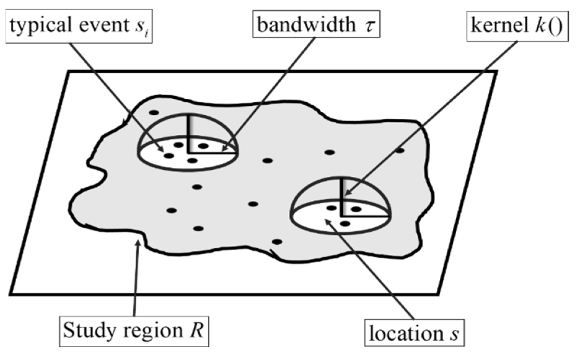
Kernel Density Estimators
2.3. A Covering Model
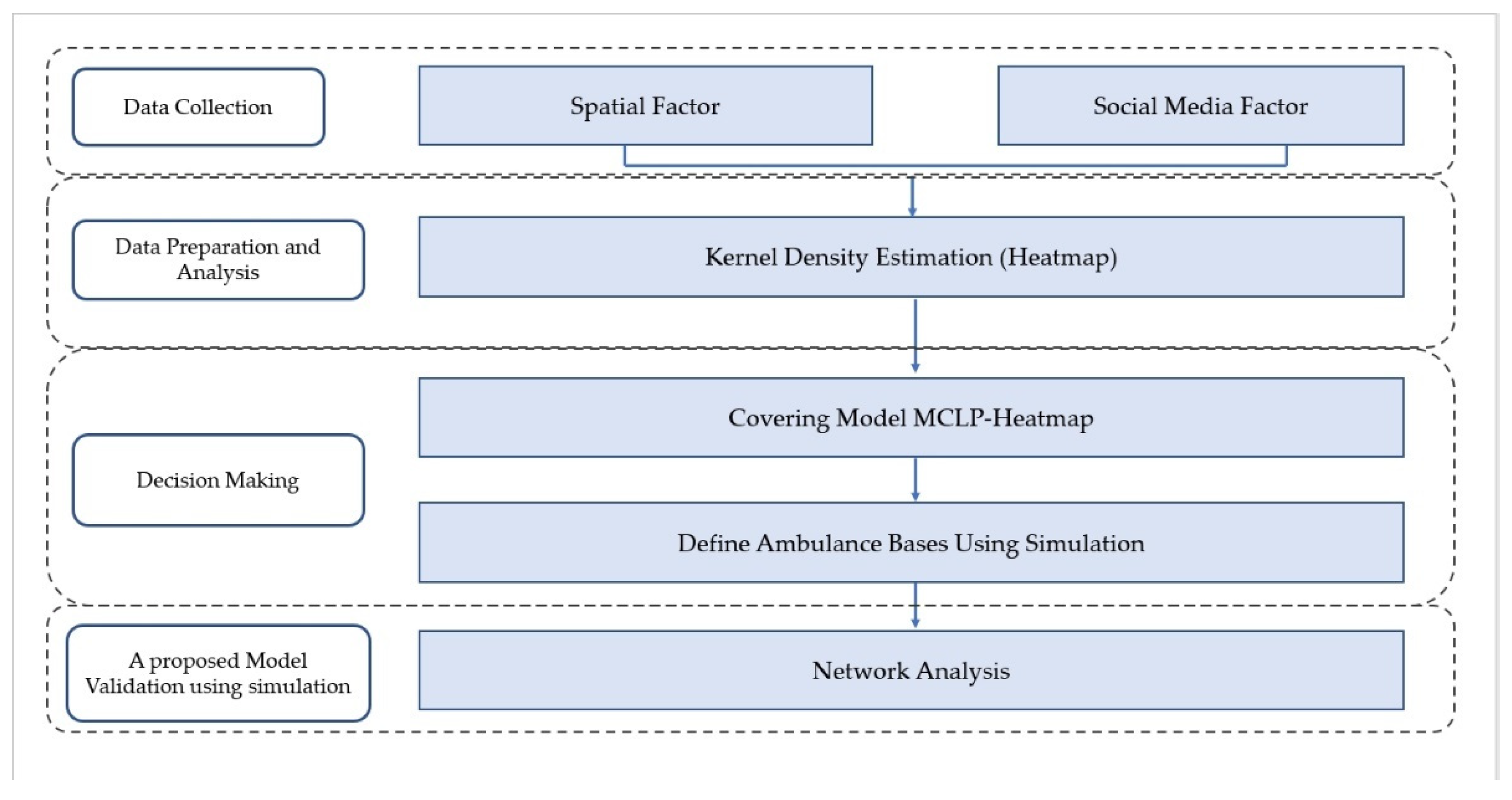
3. Our Proposed Approach
- : The density level of the area obtained from kernel density estimation.
- : The lowest density level that is used to forcibly select the standby site in area .
- : Demand in area .
- : Number of possible EMS bases.
- : A large number.
| : | If area is allocated for a standby site. | |
| Otherwise. |
| : | If area is covered by at least one standby site. | |
| Otherwise. |
- i: Area index; .
- : Possible EMS base index; .
- : A set of area.
- : A set of possible EMS bases.
- : A set of EMS bases that covers area .
3.1. Data Collection
3.2. Data Preparation and Analysis
3.3. Decision Making
3.4. Model Validating Using Simulation
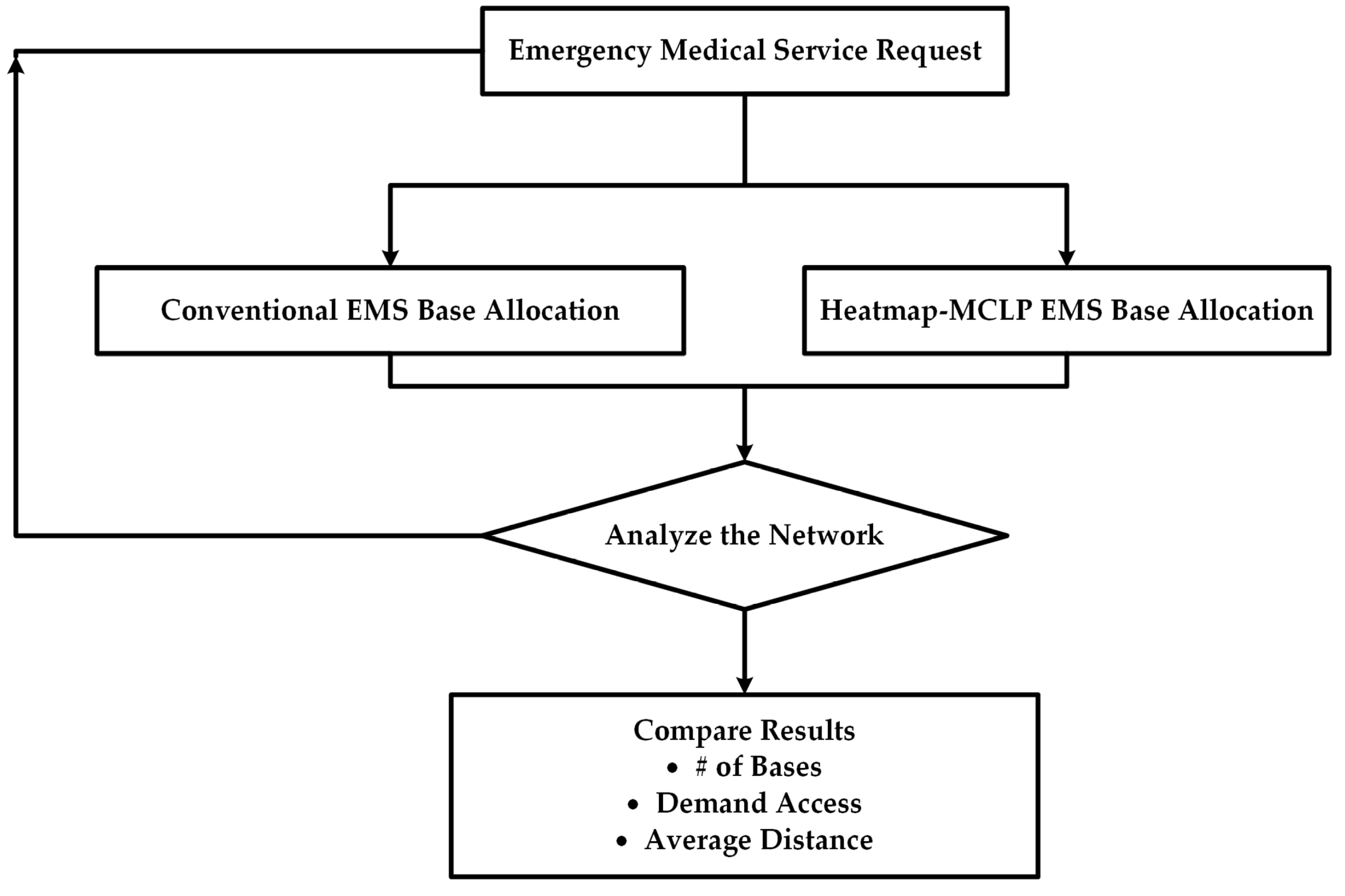
- Determine the ambulance bases obtained from the proposed covering model and the ambulance bases allocated by the existing approach (management person’s experience) for use in the simulation.
- Determine EMS request (empirical distribution)
- Analyze the road network using the location-allocation technique based on real roads.
- Compare the results in terms of bases, demand access, and average distance.
4. A Demonstration in Bangkok Area and Its Results
4.1. General Data of the Area of Study
4.2. Spatial Data and Social Media Data
4.2.1. Spatial Data
4.2.2. Social Media Data
4.2.3. Kernel Density Estimation
4.2.4. EMS Base Allocation
4.2.5. Simulation Results
5. Discussion
6. Conclusions and Future Work
Author Contributions
Funding
Conflicts of Interest
References
- Aringhieri, R.; Bruni, M.E.; Khodaparasti, S.; van Essen, J.T. Emergency medical services and beyond: Addressing new challenges through a wide literature review. Comput. Oper. Res. 2017, 78, 349–368. [Google Scholar] [CrossRef]
- Groenendaal, J.; Helsloot, I.; Scholtens, A. A critical examination of the assumptions regarding centralized coordination in large-scale emergency situations. J. Homel. Secur. Emerg. Manag. 2013, 10, 113–135. [Google Scholar] [CrossRef]
- Lim, C.S.; Mamat, R.; Braunl, T. Impact of ambulance dispatch policies on performance of emergency medical services. IEEE Trans. Intell. Transp. Syst. 2011, 12, 624–632. [Google Scholar] [CrossRef]
- De Maio, V.J.; Stiell, I.G.; Wells, G.A.; Spaite, D.W. Optimal defibrillation response intervals for maximum out-of-hospital cardiac arrest survival rates. Ann. Emerg. Med. 2003, 42, 242–250. [Google Scholar] [CrossRef] [PubMed]
- Ingolfsson, A.; Budge, S.; Erkut, E. Optimal ambulance location with random delays and travel times. Health Care Manag. Sci. 2008, 11, 262–274. [Google Scholar] [CrossRef] [PubMed]
- David, G.; Harrington, S.E. Population density and racial differences in the performance of emergency medical services. J. Health Econ. 2010, 29, 603–615. [Google Scholar] [CrossRef]
- Schmid, V.; Doerner, K.F. Ambulance location and relocation problem with time-dependent travel time. Eur. J. Oper. Res. 2010, 207, 1293–1303. [Google Scholar] [CrossRef]
- Dell’Olmo, P.; Ricciardi, N.; Sgalambro, A. A multiperiod maximal covering location model for the optimal location of intersection safety cameras on an urban traffic network. Procedia-Soc. Behav. Sci. 2014, 108, 106–117. [Google Scholar] [CrossRef]
- Van den Berg, P.L.; Aardal, K. Time-dependent MEXCLP with start-up and relocation cost. Eur. J. Oper. Res. 2015, 242, 383–389. [Google Scholar] [CrossRef]
- Van den Berg, P.L.; Kommer, G.J.; Zuzakova, B. Linear formulation for the maximum expected coverage location model with fractional coverage. Oper. Res. Health Care 2016, 8, 33–41. [Google Scholar] [CrossRef]
- Nilsang, S.; Yuangyai, C.; Cheng, C.Y.; Janjarassuk, U. Locating an ambulance base by using social media: A case study in Bangkok. Ann. Oper. Res. 2018, 283, 497–516. [Google Scholar] [CrossRef]
- Li, X.; Zhao, Z.; Zhu, X. Covering models and optimization techniques for emergency response facility location and planning: A review. Math. Methods Oper. Res. 2011, 74, 281–310. [Google Scholar] [CrossRef]
- Gatrell, A.C.; Elliott, S.J. Geographies of Health, 3rd ed.; John Wiley & Sons: New York, NY, USA, 2015. [Google Scholar]
- Kvalseth, T.O.; Deems, J.M. Statistical models of the demand for emergency medical services in an urban area. Am. J. Public Health 1979, 69, 250–255. [Google Scholar] [CrossRef]
- Schmid, V. Solving the dynamic ambulance relocation and dispatching problem using approximate dynamic programming. Eur. J. Oper. Res. 2012, 219, 611–621. [Google Scholar] [CrossRef]
- Yuangyai, C.; Nilsang, S.; Yang, C. Robust ambulance base allocation strategy with social media and traffic congestion information. J. Ambient. Intell. Humaniz. Comput. 2020, 1–4. [Google Scholar] [CrossRef]
- Martínez-Rojas, M.; del Carmen Pardo-Ferreira, M.; Rubio-Romero, J.C. Twitter as a tool for the management and analysis of emergency situations: A systematic literature review. Int. J. Inf. Manag. 2018, 43, 196–208. [Google Scholar] [CrossRef]
- Zook, M.; Graham, M.; Shelton, T.; Gorman, S. Volunteered Geographic Information and Crowdsourcing Disaster Relief: A Case Study of the Haitian Earthquake. World Med. Health Policy 2010, 2, 6–32. [Google Scholar] [CrossRef]
- Fuchs, G.; Andrienko, G.; Andrienko, N. Extracting Personal Behavioral Patterns from Geo-Referenced Tweets. In Proceedings of the 16th AGILE Conference on Geographic Information Science, Leuven, Belgium, 14–17 May 2013; pp. 71–88. [Google Scholar] [CrossRef]
- Reuter-Oppermann, M.; van den Berg, P.L.; Vile, J.L. Logistics for Emergency Medical Service systems. Health Syst. 2017, 6, 187–208. [Google Scholar] [CrossRef]
- Bird, D.; Ling, M.; Haynes, K. Flooding Facebook—the use of social media during the Queensland and Victorian floods. Aust. J. Emerg. Manag. 2012, 27, 27–33. [Google Scholar]
- Simon, T.; Goldberg, A.; Adini, B. International Journal of Information Management Socializing in emergencies—A review of the use of social media in emergency situations. Int. J. Inf. Manag. 2015, 35, 609–619. [Google Scholar] [CrossRef]
- Peacock, P.J.; Peacock, J.L. Emergency call work-load, deprivation and population density: An investigation into ambulance services across England. J. Public Health 2006, 28, 111–115. [Google Scholar] [CrossRef]
- Zhang, R.; Wu, L.; Yang, Y.; Wu, W.; Chen, Y.; Xu, M. Multi-camera multi-player tracking with deep player identification in sports video. Pattern Recognit. 2020, 102, 107260. [Google Scholar] [CrossRef]
- Zhang, R.; Xu, L.; Yu, Z.; Shi, Y.; Mu, C.; Xu, M. Deep-IRTarget: An Automatic Target Detector in Infrared Imagery Using Dual-Domain Feature Extraction and Allocation. IEEE Trans. Multimed. 2021, 24, 1735–1749. [Google Scholar] [CrossRef]
- Chang, M.; Tseng, Y.; Chen, J. A scenario planning approach for the flood emergency logistics preparation problem under uncertainty. Transp. Res. Part E Logist. Transp. Rev. 2007, 43, 737–754. [Google Scholar] [CrossRef]
- Laylavi, F.; Rajabifard, A.; Kalantari, M. Event relatedness assessment of Twitter messages for emergency response. Inf. Process. Manag. 2017, 53, 266–280. [Google Scholar] [CrossRef]
- Chaicharoenwut, P.; Koiwanit, J.; Changpetch, P.; Buatongkue, S.; Yuangyai, C. Integrating Spatial-Temporal Risk Factors for an Ambulance Allocation Strategy: A Case Study in Bangkok. MATEC Web Conf. 2018, 192, 1–4. [Google Scholar] [CrossRef][Green Version]
- Scott, D.W. Multivariate Density Estimation: Theory, Practice, and Visualization; John Wiley: New York, NY, USA, 1992. [Google Scholar]
- Grekousis, G.; Photis, Y.N.; Grekousis, G. Analyzing High-Risk Emergency Areas with GIS and Neural Networks: The Case of Athens, Greece. Prof. Geogr. 2013, 66, 124–137. [Google Scholar] [CrossRef]
- Silverman, B.W. Density Estimation: For Statistics and Data Analysis; Routledge: New York, NY, USA, 1986; Volume 1951, pp. 1–175. [Google Scholar] [CrossRef]
- Nagata, T.; Takamori, A.; Kimura, Y.; Kimura, A.; Hashizume, M.; Nakahara, S. Trauma center accessibility for road traffic injuries in Hanoi, Vietnam. J. Trauma Manag. Outcomes 2011, 5, 1–7. [Google Scholar] [CrossRef]
- Zhou, Z.; Matteson, D.S. Predicting Ambulance Demand: A Spatio-Temporal Kernel Approach Zhengyi. In Proceedings of the International Conference on Knowledge Discovery and Data Mining, Sydney, Australia, 10–13 August 2015; pp. 2297–2303. [Google Scholar]
- Srithamarong, T. Crime Risk Area Assessment Based Geo-Spatial Statistics; Silpakorn University: Bangkok, Thailand, 2016. [Google Scholar]
- Yiampisan, M.; Srivanit, M. Using the Kernel Density Estimation Surface for Criminal Pattern: A Case Study in Phranakhon District. J. Archit. Plan. Res. Stud. (JARS) 2010, 7, 87–102. [Google Scholar]
- Krisp, J.M.; Špatenková, O. Kernel Density Estimations for Visual Analysis. In Geographic Information and Cartography for Risk and Crisis Management; Springer: Berlin/Heidelberg, Germany, 2010. [Google Scholar] [CrossRef]
- Anderson, T.K. Kernel density estimation and K-means clustering to profile road accident hotspots. Accid. Anal. Prev. 2009, 41, 359–364. [Google Scholar] [CrossRef]
- Borruso, G. Network Density Estimation: A GIS Approach for Analysing Point Patterns in a Network Space. Trans. GIS 2008, 12, 377–402. [Google Scholar] [CrossRef]
- Vafaeinejad, A.; Bolouri, S.; Alesheikh, A.A.; Panahi, M.; Lee, C.-W. The Capacitated Location-Allocation Problem Using the VAOMP (Vector Assignment Ordered Median Problem) Unified Approach in GIS (Geospatial Information Systam). Appl. Sci. 2020, 10, 8505. [Google Scholar] [CrossRef]
- Sher, M.; Adler, N.; Hakkert, A. The Police Vehicle Location-allocation Problem. In Proceedings of the International Conference on Industrial Logistics, Tel Aviv, Israel, 9–15 March 2008. [Google Scholar]
- Daskin, M.S.; Maass, K.L. The p-median problem. In Location Science; Springer International Publishing: Cham, Switzerland, 2015; pp. 21–45. [Google Scholar]
- Farahani, R.Z.; Asgari, N.; Heidari, N.; Hosseininia, M.; Goh, M. Covering problems in facility location: A review. Comput. Ind. Eng. 2012, 62, 368–407. [Google Scholar] [CrossRef]
- Erdemir, E.T.; Batta, R.; Rogerson, P.A.; Blatt, A.; Flanigan, M. Joint ground and air emergency medical services coverage models: A greedy heuristic solution approach. Eur. J. Oper. Res. 2010, 207, 736–749. [Google Scholar] [CrossRef]
- Zhen, L.; Wang, K.; Hu, H.; Chang, D. A simulation optimization framework for ambulance deployment and relocation problems. Comput. Ind. Eng. 2014, 72, 12–23. [Google Scholar] [CrossRef]
- Toregas, C.; Swain, R.; ReVelle, C.; Bergman, L. The Location of Emergency Service Facilities. Oper. Res. 1971, 19, 1363–1373. [Google Scholar] [CrossRef]
- Church, R.; Revelle, C. The Maximal Covering Location Problem. Pap. Reg. Sci. Assoc. 1974, 32, 101–118. [Google Scholar] [CrossRef]
- Nefros, K.C.; Kitsara, G.S.; Photis, Y.N. Using Geographic Information Systems (GIS) to develop prioritization maps in urban search and rescue operations, after a natural disaster. Case study: The municipality of Agia Paraskevi, Athens, Greece. IFAC-PapersOnLine 2018, 51, 360–365. [Google Scholar] [CrossRef]
- Matinrad, N.; Granberg, A. Forecasting the Demand for Emergency Medical Services. In Proceedings of the Hawaii International Conference on System Sciences, Maui, HI, USA, 8–11 January 2019; Volume 6, pp. 1855–1864. [Google Scholar]
- Road Accident Victims Protection Co. Ltd. Available online: http://www.thairsc.com/p77/index/10 (accessed on 15 April 2020).
- Bangkok Strategy and Evaluation Department. 2016. Available online: http://203.155.220.230/m.info/bkkstat/stat_2559_thai.pdf (accessed on 20 May 2022).
- Bangkok Geopraphical Information System. 2020. Available online: http://www.bangkokgis.com/modules.php?m=download_shapefile (accessed on 20 May 2022).
- Bangkok Public Works Department. 2020. Available online: http://www.bangkok.go.th/yota/ (accessed on 20 May 2022).
- Ratanavaraha, V.; Suangka, S. Impacts of accident severity factors and loss values of crashes on expressways in Thailand. IATSS Res. 2014, 37, 130–136. [Google Scholar] [CrossRef]



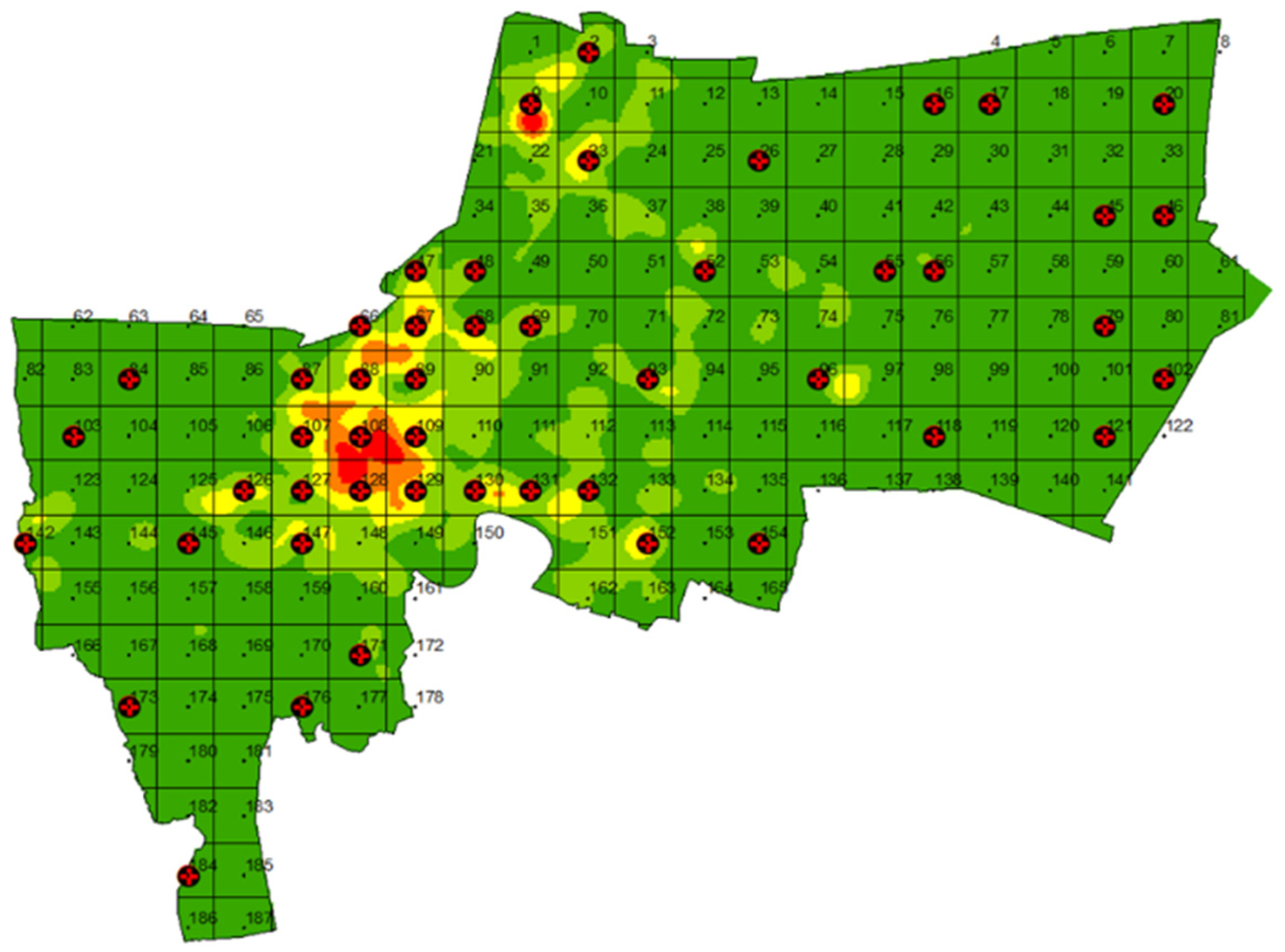
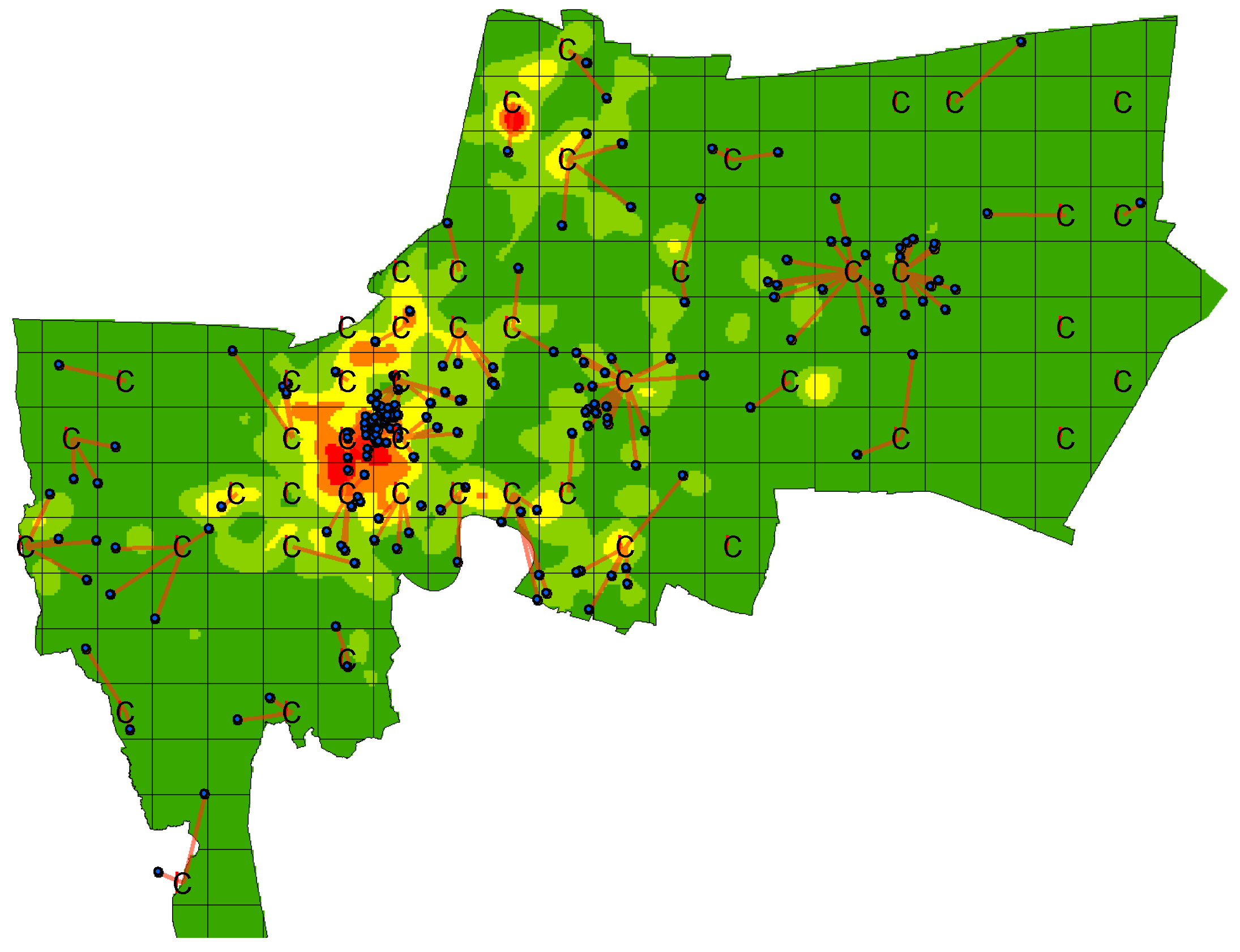
| Color | Meaning | Density Level |
|---|---|---|
| Red | Very high chance of emergency medical service request | 5 |
| Orange | High chance of emergency medical service request | 4 |
| Yellow | Moderate chance of emergency medical service request | 3 |
| Light Green | Low chance of emergency medical service request | 2 |
| Dark Green | Very low chance of emergency medical service request | 1 |
| No. | Type of Place | Number |
|---|---|---|
| 1. | Risky Intersection | 81 |
| 2. | Community | 2011 |
| 3. | BTS (skytrain) | 30 |
| 4. | MRT (metro) | 18 |
| 5. | Fresh market | 148 |
| 6. | Flood area | 323 |
| 7. | Shopping mall | 127 |
| Total | 2738 |
| Incident | Keyword | Report Frequency |
|---|---|---|
| Road Accident | Two-car clash | 6 |
| Car-motorcycle clash | 5 | |
| Car hit Street-isle | 3 | |
| Two-motorcycle clash | 5 | |
| Lost-controlled motorcycle | 7 | |
| Fallen motorcycle | 3 | |
| Two-truck clash | 7 | |
| Truck fall off the road | 1 | |
| Car, truck and motorcycle clash | 1 | |
| Flipped SUV | 1 | |
| Lost-controlled car | 1 | |
| A car clash | 19 | |
| Lost-controlled car hit | 2 | |
| Lost-controlled soil grader | 1 | |
| Motorcycle clash | 25 | |
| Car clash | 31 | |
| Van-motorcycle clash | 1 | |
| Trailer clash | 5 | |
| Lost-controlled trailer | 1 | |
| Truck clash | 11 | |
| Lost-controlled clash | 2 | |
| Accident | 95 | |
| Total | 233 | |
| Fire | Fire | 73 |
| Total | 73 | |
| Flood | Flood | 7 |
| Water waiting to drain | 3 | |
| Total | 10 | |
| Total Incident | 316 |
| Subarea | Standby Site |
|---|---|
| 2, 9, 16, 17, 20, 23, 26, 45, 46, 47, 48, 52, 55, 56, 66, 67, 68, 69, 79, 84, 87, 88, 89, 93, 96, 102, 103, 107, 108, 109, 118, 121, 126, 127, 128, 129, 130, 131, 132, 142, 145, 147, 152, 154, 171, 173, 176, 184 | Allocated (48 bases) |
| 1, 3, 8, 10, 14, 21, 22, 24, 25, 28, 29, 31, 32, 34, 42, 44, 49, 50, 51, 65, 70, 71, 73, 75, 76, 77, 78, 80, 82, 83, 86, 91, 92, 94, 95, 99, 104, 106, 110, 111, 112, 113, 114, 115, 117, 119, 120, 122, 123, 124, 125,133, 135, 137, 138, 140, 141, 143, 144, 146, 148, 149, 151, 153, 155, 156, 157, 158, 159, 160, 161, 162, 163, 164, 165, 166, 167, 168, 169, 170, 172, 174, 175, 177, 178, 179, 180, 181, 182, 183, 185, 186, 187 | Not Allocated (139 bases) |
| No. | MCLP-Heatmap (48 Locations) | Current Emergency Ambulance Bases (59 Locations) | ||||||
|---|---|---|---|---|---|---|---|---|
| Bases | Demand Access | Avg. Dist. (Meter) | SD. | Bases | Demand Access | Avg. Dist. (Meter) | SD. | |
| 1 | 40 | 183 | 3554.91 | 1912.85 | 46 | 175 | 2922.16 | 2135.74 |
| 2 | 38 | 184 | 3437.11 | 1814.99 | 47 | 179 | 3162.5 | 2338.56 |
| 3 | 34 | 182 | 3473.40 | 1811.34 | 45 | 179 | 3234.4 | 2424.14 |
| 4 | 38 | 186 | 3446.99 | 1887.49 | 49 | 178 | 3094.18 | 2188.60 |
| 5 | 39 | 183 | 3389.75 | 1994.36 | 51 | 174 | 3026.53 | 2100.30 |
| 6 | 37 | 179 | 3555.87 | 1934.54 | 49 | 174 | 3157.67 | 2363.94 |
| 7 | 36 | 183 | 3215.01 | 1875.58 | 48 | 179 | 3104.8 | 2337.71 |
| 8 | 40 | 185 | 3461.70 | 1833.09 | 50 | 177 | 3062.48 | 2287.46 |
| 9 | 41 | 184 | 3432.11 | 1916.46 | 50 | 176 | 3299.99 | 2542.19 |
| 10 | 38 | 182 | 3619.93 | 1992.12 | 47 | 175 | 3290.46 | 2497.60 |
| CI 95% | (36.6, 36.7) | (181.7, 184.7) | (3387, 3562) | - | (46.8, 49.6) | (175.1, 178.1) | (3019, 3235) | - |
Publisher’s Note: MDPI stays neutral with regard to jurisdictional claims in published maps and institutional affiliations. |
© 2022 by the authors. Licensee MDPI, Basel, Switzerland. This article is an open access article distributed under the terms and conditions of the Creative Commons Attribution (CC BY) license (https://creativecommons.org/licenses/by/4.0/).
Share and Cite
Jientrakul, R.; Yuangyai, C.; Boonkul, K.; Chaicharoenwut, P.; Nilsang, S.; Pimsakul, S. Integrating Spatial Risk Factors with Social Media Data Analysis for an Ambulance Allocation Strategy: A Case Study in Bangkok. Sustainability 2022, 14, 10247. https://doi.org/10.3390/su141610247
Jientrakul R, Yuangyai C, Boonkul K, Chaicharoenwut P, Nilsang S, Pimsakul S. Integrating Spatial Risk Factors with Social Media Data Analysis for an Ambulance Allocation Strategy: A Case Study in Bangkok. Sustainability. 2022; 14(16):10247. https://doi.org/10.3390/su141610247
Chicago/Turabian StyleJientrakul, Ranon, Chumpol Yuangyai, Klongkwan Boonkul, Pakinai Chaicharoenwut, Suriyaphong Nilsang, and Sittiporn Pimsakul. 2022. "Integrating Spatial Risk Factors with Social Media Data Analysis for an Ambulance Allocation Strategy: A Case Study in Bangkok" Sustainability 14, no. 16: 10247. https://doi.org/10.3390/su141610247
APA StyleJientrakul, R., Yuangyai, C., Boonkul, K., Chaicharoenwut, P., Nilsang, S., & Pimsakul, S. (2022). Integrating Spatial Risk Factors with Social Media Data Analysis for an Ambulance Allocation Strategy: A Case Study in Bangkok. Sustainability, 14(16), 10247. https://doi.org/10.3390/su141610247


