Article

Analysis of the Sustainable Development Index in the Communes of the Podkarpackie Voivodeship: A Polish Case Study

1
The Faculty of Civil, Environmental Engineering and Architecture, Rzeszow University of Technology, 35-959 Rzeszow, Poland
2
Faculty of Economy and Public Administration, Cracow University of Economics, 31-510 Cracow, Poland
*
Author to whom correspondence should be addressed.
Sustainability 2022, 14(16), 10237; https://doi.org/10.3390/su141610237
Submission received: 17 June 2022 / Revised: 30 July 2022 / Accepted: 7 August 2022 / Published: 17 August 2022
(This article belongs to the Special Issue Shaping towards Sustainability in Architecture and Civil Engineering)

Abstract

:
Intense global urbanization, including spatial planning development, is an essential area that determines sustainable development. It is known that urban development is typically tied to an increase in socioeconomic productivity while also creating considerable inequalities. Despite mounting evidence of intense urban area development, little is known about its consequences on the sustainable development of territories adjacent to said areas. Despite the positive and negative consequences of urbanization and their impact on sustainable development often being highlighted, there is little understanding of and a dearth of analyses on sustainability processes that include spatial planning development. To fill this gap, it must be assessed where sustainable development is actually taking place. Such analyses should not only be confined to the four essential areas: economic development, social development, environmental development, and institutional development, that are tied to sustainable development index calculations. They should also determine the transformations experienced by the areas and factor in a fifth analysis area: spatial planning development. In this paper, detailed data sourced from the Statistics Poland were used to formulate sustainable development indices for urban, rural–urban, and rural communes of the Podkarpackie region of Poland. The data concerned the five areas listed above. Using data standardization and the averaged index method, sustainable development index values were quantified to demonstrate that they displayed various levels of inequalities for the two reference periods of 2015 and 2020. These statistics indicate the key role of spatial planning development in assessing sustainability indices. The findings show that it is not only possible to enhance standard calculation methods to include other data and use them in time and space to create a simple and general quantitative rating of sustainable development, but urbanization can also be factored in that includes spatial planning development. The findings show that a modified computation approach is a reliable and relatively complete index of sustainable development that compensates for the deficiencies of current metrics.

1. Introduction

Since defining sustainable development as a term by the G. Brundtland Commission on Environment and Development and the adoption of the Agenda 2030 and Sustainable Development Goals by United Nations Member States [1], both state governments of individual countries and researchers/scholars take action to study and monitor progress in this regard [2,3]. The goals of sustainable development were proposed to balance three areas: society, economy, and the environment [1]. To achieve sustainable development, it is necessary to make these areas sustainable in a holistic and compatible manner [4].
The complete set of actions towards achieving sustainable development is also being undertaken in Europe, including Poland, and was formulated in “Transforming our world: The 2030 Agenda for Sustainable Development.” It includes the 17 Sustainable Development Goals (SDGs), as well as 169 associated tasks. These tasks are also being carried out in three areas of sustainable development and concern achievements in five dimensions, the so-called 5 × P: people, planet, prosperity, peace, and partnership. The goals cover a wide range of challenges such as poverty, hunger, health, education, gender equality, climate change, sustainable development, peace, and social equity [5]. A set of 231 indices was defined for the purposes of implementing the Agenda and to facilitate constant global monitoring of its progress all over the world. Meanwhile, the implementation of sustainable development goals in countries of the European Union Member States is monitored using the Agenda 2030 index set and is reported annually by Eurostat [6,7]. Index studies of sustainable development levels carried out in these countries are typically carried out at the city and voluminous level [8,9,10] or at the state level internationally [11,12,13]. Their results are used to program regional and national development and to define strategic goals. Shaping development at the voivodeship level requires an analysis of their main administrative units, namely, communes [14].
In Poland, the implementation of the development priorities of Agenda 2030’s development priorities is primarily based on the Responsible Development Strategy (RDS) adopted in 2017, in addition to other strategic documents that define the country’s development model. They include the pursuit of increasing the role of human and social capital as a basis for the economy, building a strong industry, and entrepreneurship. Improving the environment and sustainable resource management is particularly essential, as it ensures economic development and a high quality of life while also ensuring development potential for future generations.
The highest legal Act in Poland, the Constitution, stipulates in Article 5 that sustainable development is one of the main principles of the country’s political system and a trajectory of its policy [15]. The sustainable development of the country, recognized as a constitutional principle of the Republic of Poland, was defined in the Environmental Protection Act as “socioeconomic development in which there is a process of integration of political, economic, and social actions while maintaining environmental balance and the continuation of fundamental environmental processes to ensure the ability of communities and citizens of current and future generations to meet their essential needs” [16].
The implementation of Sustainable Development Goals in Poland is monitored in terms of action taken to achieve each goal. It is also interesting that in Poland, an application dedicated to businesses has been developed and that can also be of use for other entities such as communes. The Barometr Wpływu (Influence Barometer in English) application is a tool that measures a business’s contribution to implementing Agenda 2030 in Poland, which was developed as a part of the 17 Goals Campaign. Every business can use the application free of charge. The analysis of the collective results of Polish businesses will enable the verification of progress in implementing priority Sustainable Development Goals and aid in identifying areas where action should be taken by businesses. It is the first Polish set of SDG metrics for businesses [17].
It should be stressed that, in Poland, previous practices concerning the implementation of sustainable development principles at the regional and commune level, did not yield satisfying results and were typically focused solely on cities. At the local level, especially in rural communes, there is a lack of permanent and continuous sustainable development-level monitoring. Consequently, sustainability was not factored into the management and drafting of spatial policies aimed to create a friendly and sustainable place for inhabitants [18]. The responsibility of local governments for the quality of life of citizens that is still growing in Poland forces changes in commune management, as these entities should focus on achieving the balance between key areas such as economic, social, environmental, institutional, and spatial development [1]. Instruments that could help manage communes are sustainable development indices. They are used not only as an essential monitoring tool, but also to measurably present the essence of this concept of sustainable development. They also allow for an analysis of the static image of an area from the standpoint of implementing the new development paradigm.
It should be highlighted that authorities in most countries assume sustainable development as a priority goal of their own development strategies or other programs and projects, and implement various index systems to assess sustainable development [19]. These indices present the level of implementation of the SDG, on the one hand, while on the other, they facilitate the implementation of public policies [19,20,21,22,23,24,25].
Most researchers agree that the actions taken in recent decades by the governments of most countries were superficial and oriented toward image building and political action rather than operational action [26,27,28,29,30]. The worsening climate situation also now shows that long-promoted slogans related to making development more sustainable in relation to environmental processes that have been promoted for several decades have not had a significant impact in terms of constructive efforts towards their implementation [31]. The findings of academic studies that have long since pointed to the dangers of exploiting the natural environment of the Earth did not result in effective and pragmatic action on the part of governments. An example is the underestimation of the speed and scope of climate change and the increase in sea and ocean levels [32,33,34].
The rapid climate change observed across the world shows that Earth’s exploitation must be stopped as soon as possible. Therefore, the subject of sustainable development continues to be discussed by analysts and academics who search for new tools and methods of changing the status quo not only at the international level, but also at the local level of individual countries or their regions. The pursuit of sustainable development applies to both urban and rural areas. The former typically becomes the subject of investigations and analyses. This is related to the dominant role of cities as growth drivers in territorial structures. The predominance of urban subject matter is also tied to the scale of the impact that cities exert on the natural environment and the economy, which requires taking action primarily in those units. Rural areas also undergo a constant transformation, and the spatial changes that affect them are primarily tied to changes in land use. These processes are usually highly dynamic and cause sudden changes that take the form of “rurbanization” in rural areas [35]. Therefore, when determining the potential for effective and sustainable development, the said development must be examined from the local level (the commune level in the case of Poland), followed by the regional (voivodeships), state, and continent level, and finally the global level. Some voices also argue that each and every element of the system, no matter how small, whether a single user or a household, is crucial to the process of implementing sustainable development. Cooperation at all levels can increase the number of initiatives taken in this regard and improve its dynamics and effectiveness [36].
The main objective of the research is to analyze the actual level of advancement of basic territorial units in implementing the principles of sustainable development in terms of the Podkarpackie Voivodeship. The study, which was carried out at the level of all municipalities of the voivodeship, made it possible to determine the ranking of individual territorial units regardless of their nature (Supplementary File S1). At subsequent stages of the research work, the presented research procedure will be developed in terms of the selection of measures and the advancement of data aggregation. The applied purpose of the work is to present the possibility of the municipal government to choose the path leading to a state of balancing development in several key areas, including spatial resource management. The applicative character of this method and its advantages in Polish conditions merit its broader use and correlation with the results obtained using other methods. No research on the level of the Sustainable Development Index for all municipalities in Pokarpacie was found over the course of this study. Research investigating the monitoring of Sustainable Development Index levels in which spatial management was analysed separately was also included.
The shaping of sustainable development as a principle of stabilizing economic and social phenomena in the context of the natural environment creates a need to also account for spatial changes [37]. Spatial planning pertains to both urban and rural environments, as well as to naturally valuable areas. The quality of their development creates a direct correlation with environmental aspects (wildlife and ecosystem conservation), as well as social (e.g., quality of life, social integration) and economic ones (e.g., tourism). Therefore, in this study, the spatial planning system, as an important instrument of shaping sustainable development [38], was taken into account.

2. Literature Review

Formulating indices that both allow the grasp of numerous aspects/areas of sustainable development is of crucial significance to understanding and measuring it. The Human Development Index (HDI) was a precursor of this methodology and emphasized income, health, and education [39,40]. In the socioeconomic dimension, the HDI was developed by the United Nations Development Programme to assess social development in various countries [41]. As an alternative to the gross domestic product (GDP), in which people are the focal point, HDI became a widely used measure of human progress [42]. Numerous studies stipulated that human development extends beyond these three indices and includes other factors such as employment, freedom, and public governance [43]. In the light of the deficiencies of the HDI, many researchers attempt to correct it. Despite gaining knowledge on multidimensional approaches to sustainable development, it remains key not only to build integrated indices, but to formulate assessments that cover multiple areas [44]. For instance, in [45,46], it was proposed to use an index-based method to rate energy and groundwater resources. The Sustainable Development Index (SDI) was formulated in [47] to assess and improve sustainable development at the commune level using numerous metrics that represent social, economic, and environmental features. The proposal put forth in [48], namely, the use of an SDI that measures the ecological effectiveness of human development, is an interesting approach. The fact that each parameter/factor from the various areas of sustainable development is interchangeable by default and one parameter can obscure another is an essential problem in analyzing sustainable development. This results in conflicting interdependencies, as indicated in [49]. Thus, weak sustainable development allows for the mutual replacement of natural capital (e.g., natural resources, clean air) and human-made capital (e.g., buildings and urban infrastructure). Meanwhile, strong sustainable development assumes that human-made capital and natural capital should complement each other to ensure environmental integrity, while also satisfying human needs [49,50]. However, it should be remembered that an environmental factor, namely, the depletion of natural resources, is an irreversible and threshold phenomenon [50], and human-made capital is not and should not be seen as a substitute for natural capital [51,52]. Due to this, it was highlighted in [53] that from a perspective of high sustainability, an assessment of regional sustainable development is necessary. Strong sustainable development assumes that natural capital is not replaced, and the environmental factor is as important in assessing sustainable development as social and economic factors are. This principle allows us to avoid the mutual substitution of natural and human-made capital.
Linear order, which is a multidimensional comparative analysis method that includes additive aggregation to add standardized sub-indicator values to create an averaged sustainable development index, is the most frequently used sustainable development assessment method [54]. Additive aggregation means that there is no synergy or conflict between the various indices [55] and that there is a complex link between factors that cannot be mutually substituted [54]. One of the strengths of additive assessment is that in rating sustainable development, one can cover various areas/aspects, and such an approach was used in this paper. Despite it being typical to employ four areas in sustainable development assessment, namely, economic development, social development, environmental development, and institutional development, this study added a fifth area: spatial planning development. It is generally known that the current global urbanization process, including the development of spatial planning, not only creates an opportunity for widespread socioeconomic development, but is also an immense challenge to the sustainability of various territorial administration units [56,57]. Mechanisms that generate better living conditions and economic development, as well as those that most often increase overall energy and resource consumption, are still only partially identified at the city, region, and country level [58,59,60]. Recent studies pointed to the negative consequences of increasing population numbers [61]. The type and scope of these impacts differ and include air and water pollution, changes in land cover, loss of natural habitats, increased load on water resources, increased energy demand, and higher greenhouse gas emissions [62,63]. To determine the impact of spatial planning development on the sustainable development of the regional scale, one should focus on how and where this development takes place [64], not only within cities, but also in terms of the changes experienced by neighboring rural–urban and rural communes [65,66]. Local-scale analysis indicates changes towards more sustainable development, especially in combination with greater access to urban services [31,59,63,67] that enhance health and provide access to and cause a greater energy and water consumption, while having a significantly lower negative impact on the environment in terms of land use, polluted wastewater, or CO2 emissions.
The positive correlation between urbanization and many important dimensions of social development is increasingly prominent. The link between higher levels of urbanization and economic productivity per person has been noticed for some time [57]. Citywide data analyses confirm the positive link between urbanization and better health, education, longer life spans, and better access to essential services or water and electricity [57,58].
Regardless of whether positive or negative impacts of urbanization are stressed, there is still a lack of a more systematic understanding of sustainable development processes, one that would be based on reliable data and empirical studies. This article is an answer to the need to combine various areas, including processes that induce change, in integrated analyses on regional sustainable development, with an emphasis on spatial planning development and quantitative data sourced from statistical office databases (in this case, the Statistics Poland) at various scales, from that of a city to that of a rural community. This study features analyses performed for the Podkarpackie Voivodeship in Poland, where progress in achieving sustainable development goals has been carefully monitored. By factoring in the socioeconomic, environmental, institutional, and spatial planning dimensions in combination with the notion of sustainability, this paper proposes a basis for a comprehensive quantitative assessment of regional sustainable development by comparing two reference periods: 2015 and 2020. This paper is also intended to promote regional sustainable development that accounts for the development of spatial planning.

3. Materials and Methods
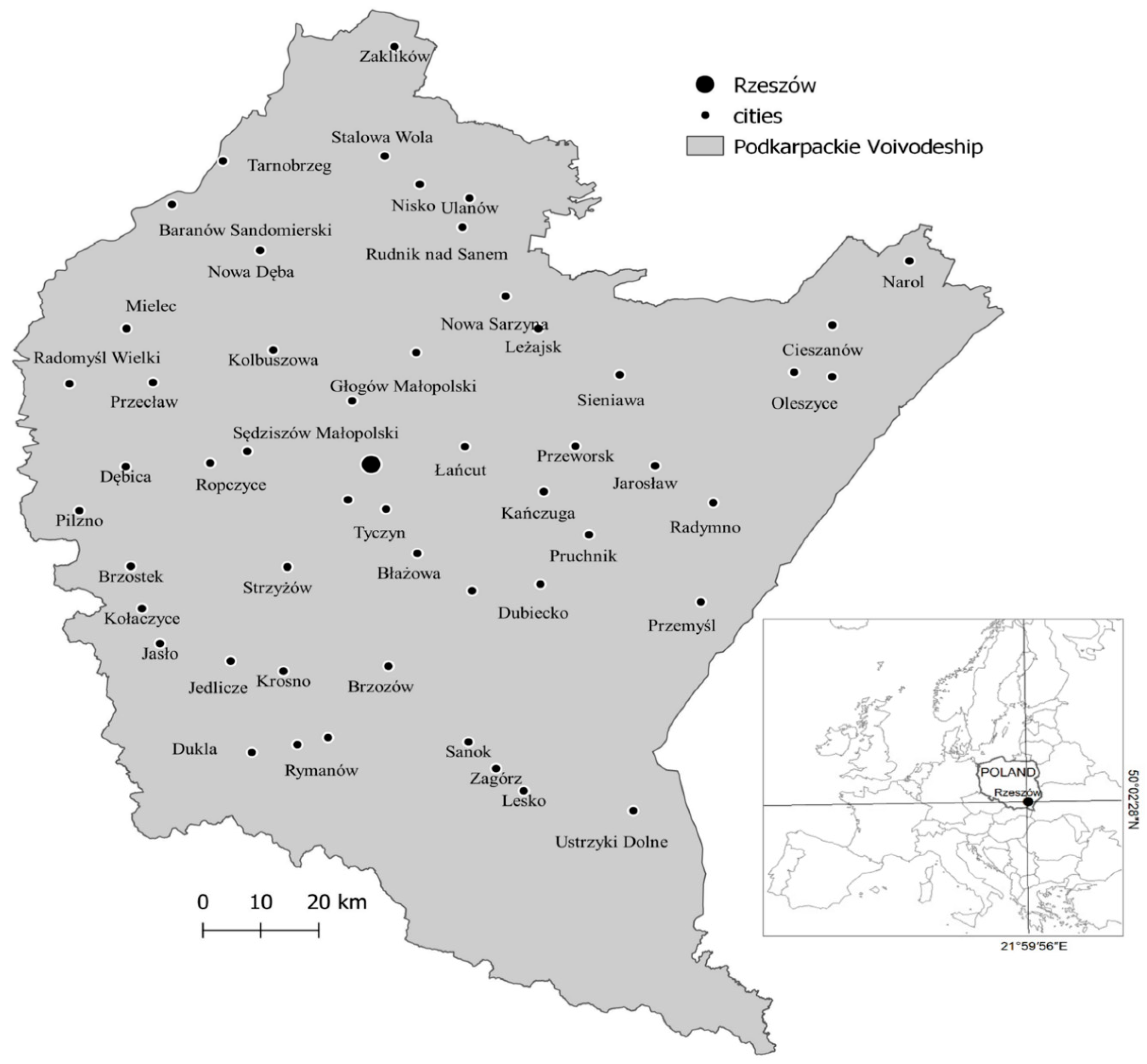
3.1. Study Area

The Podkarpackie Voivodeship is one of Poland’s 16 voivodeships, which were established in 1999 (Table 1). It is located on the southeast edge of Poland, and is the southernmost voivodeship in the country. The Podkarpackie Voivodeship is an area that has a nationally outstanding development pace and scale. Its dynamically developing industry branches include aviation, electronic machinery, the chemical industry, and technologies. Special economic zones play an important role in the economic development of the region and typically support existing and newly founded economic entities. Another of the strengths of the region is its road infrastructure, which is a link between the east and west of economic Europe, as well as the operation of Jasionka Airport. Rzeszów is the capital of the voivodeship and the seat of central and local government institutions, and is the largest city in the region.
In the Polish literature, there is a range of multidimensional studies and analyses, both of the Podkarpackie Voivodeship [68,69,70,71] and comparative studies for all regions [72,73,74,75]. An analysis of the socioeconomic situation was presented in a report by the Rzeszów Voivodeship Statistics Office [76]. A well-developed and uniformly distributed hierarchical city structure, with a slight predominance of Rzeszów, was presented in a SWOT analysis [77] as a strength of the voivodeship (Figure 1). Furthermore, the rich network of small towns that act as local centers of development and concentrations of services for their respective areas was also presented as the strength of the voivodeship. This also proves that the entire voivodeship has considerable development potential to become a strong and sustainable region.
The Podkarpackie Voivodeship consists of 160 communes. Most of these, numbering 109, are rural and urban communes, 16 are urban communes, and 35 are rural communes.
It was found that spatial policy in the Podkarpackie Voivodeship was at a comparatively good level. This is shown by the high position of the voivodeship in the ranking of the share of area with enforceable local spatial development plans relative to the total area of a voivodeship (Figure 2, Supplementary File S1). Local spatial development plans considerably affect the enforcement of spatial order and ensure that communes enjoy sustainable development, as a high percentage of areas with enforceable plans is a tool of implementing a commune’s spatial policy. In addition, the provisions of such plans define long-term spatial development guidelines and thus prevent spatial chaos in communes. They also reduce the risk of irregularities in projects sited in areas with special conditions (e.g., areas at risk of being flooded). This enables the conservation of an area’s natural and cultural resources of an area and minimizes the economic consequences of poor spatial management.
The choice of the Podkarpackie Voivodeship as the case for the study was dictated by a range of arguments. First, no similar studies were found in this area and it was observed that there were high development dynamics compared to the rest of the country [78]. Other arguments in favor of studying the voivodeship of Podkarpackie include the spatial specificity of the voivodeship, namely, the relatively uniform distribution of urban centers, a considerable number of forested areas, and its proximity to Ukraine, which is not an EU member. It should be stressed that the area for investigation was not selected randomly. No studies of Sustainable Development Indices (SDI) were found for all communes of the Podkarpackie Voivodeship, nor were Polish studies of SDI monitoring that would also account for a separate analytical area of spatial management.

3.2. Materials

This study was based on the phenomena described using numerical data that can be said to measure levels of sustainable development. The data were collected from Statistics Poland (GUS) databases, which were selected on the basis of an analysis of the literature. The analysis of the literature in terms of the selection of characteristics of sustainable development allowed the identification of metrics that describe individual areas. The guidelines used to select the metrics were as follows: select a metric that best describes a given phenomenon, the variability of the metric over time, and comparability over time and space in the form of relative metrics such as percentages or per-capita values. In addition, the study included sustainable development indices published by the Statistics Poland (Główny Urząd Statystyczny, GUS) [79]. Unfortunately, a considerable portion of the indices listed there was not available for the smallest territorial unit, the commune, and this study focused on analyzing the levels of sustainable development across the entire Podkarpackie Voivodeship. The final selection of the metric was dictated by the availability and uniformity of the data available for all municipalities of the voivodeship (urban, rural, and rural–urban communes).

3.3. Methods

Sustainable development is a complex process of change, which also includes space; it covers multiple aspects, and is expressed via many detailed characteristics. Sustainable development analysis as a phenomenon is typically performed using synthetic indices that enable the replacement of multiple metrics with a single value. The linking of various aspects and their mutual balancing leads to synergy and, thus, to sustainable development [1,80,81].
Linear order was chosen as the procedure, as it is a method used in multidimensional comparative analysis (MCA) and uses simple calculations [82]. The effect of the analyses performed using the proposed method is to sort objects from best to worst, and the ordering criterion is the level of a complex phenomenon—in other words, the end result is a ranking (Supplementary File S1). Variables can act as stimulants or inhibitors [83]. Object linear ordering, namely, ranking, should be preceded by the selection of a suitable standardization formula. The most suitable formulas are those that result in stable or almost-stable standardized variability intervals. Standardization is intended to unify diagnostic properties expressed in various units of measurement and in a diverse range of numerical scopes. Standardization methods are used to transform absolute values into relative values and to either remove measures or unify numerical scopes. In this study, a method based on quotient transformation was used, whose point of reference was the range of the variable —this standardization method is characterized by using a constant point of reference, which is the range of the standardized variable [84]. This method, also called the averaged index method in spatial analysis, is simple and shows little loss of information during data aggregation. Due to the analysis of all communes, the results must be comparable for all 160 communes. The method used to calculate sustainable development indices in this study is objective, reliable, universal, and accounts for diverse developmental conditions of individual communes, and is based on official statistical data sourced from the Statistics Poland, which ensures its reliability.
This study was based on the phenomena described using numerical data that can be said to measure levels of sustainable development. The data were collected from Statistics Poland, databases, which were selected on the basis of an analysis of the literature. The analysis of the literature in terms of the selection of characteristics of sustainable development allowed the identification of metrics that describe individual areas. The guidelines used to select the metrics were as follows: select a metric that best describes a given phenomenon, the variability of the metric over time, and comparability over time and space in the form of relative metrics such as percentages or per-capita values. In addition, the study included sustainable development indices published by the Statistics Poland (Główny Urząd Statystyczny, GUS) [36]. Unfortunately, a considerable portion of the indices listed there was not available for the smallest territorial unit—the commune—and this study was focused on analyzing sustainable development levels across the entire Podkarpackie Voivodeship. The final metric selection was dictated by the availability and uniformity of the data available for all of the voivodeship’s communes (urban, rural, and rural–urban communes).
The rankings were based on a set of detailed indices (metrics) that were assigned to one of the five areas of sustainable development. Five areas were selected in the study, which were then used as synthetic indices that comprehensively characterize the process of adaptation of each of the voivodeship communes to the sustainable development paradigm. A total of 34 detailed metrics were defined (Table 2).
Economic development, which consists of five detailed metrics, is understood as the capacity of a population to generate higher income due to entrepreneurship. The Sustainable Development Rating in the Economic Area focuses on the economic condition of a commune, using metrics that refer to the number of entities and natural persons who engage in economic activity, newly registered businesses in a given year, the budget income of the commune, and the scope to which a population uses public aid.
Social development is understood as the potential of a population for self-improvement and enhancing its quality of life. In the study, it consisted of nine detailed metrics. The area of society focuses on the current quality of life and the perspective of future generations. Elements such as health, demographics, and access to healthcare and education are the basis for sustainable social development.
Environmental development consisted of four metrics and is defined as the manner of use of technical infrastructure that limits environmental pollution and allows the rational use of environmental assets. The environmental area was mostly focused on elements of physical space that significantly affect the health and wellbeing of a population, such as air quality, rational water resource management, and access to network infrastructure.
Institutional development is defined as the capacity of local government institutions to effectively and inclusively manage human and environmental resources and consists of five metrics. Here, the key metrics were those that characterized civil society and gender quotas, as well as municipal spending on education and culture.
This study also investigated development in terms of spatial planning, which was not previously featured in other studies and sustainable development measurements, at least in Poland, which is the novel element of the study. Development in terms of spatial planning was determined based on 11 metrics and defines the quality of spatial policy in a commune as a part of applicable legal regulations, including the number and scope of enforceable local spatial development plans. The highest number of metrics were defined for the spatial planning area, which defines a commune’s advancement in managing spatial resources. The key metrics were associated with enforceable local spatial development plans, planning permits for housing, public, commercial, and service uses.
A set of metrics intended for further calculation/aggregation is presented in Table 2. The analysis and calculations were performed in an Excel sheet in two tabs: one for 2015 and one for 2020. Each value was standardized according to Equations (1)–(8).

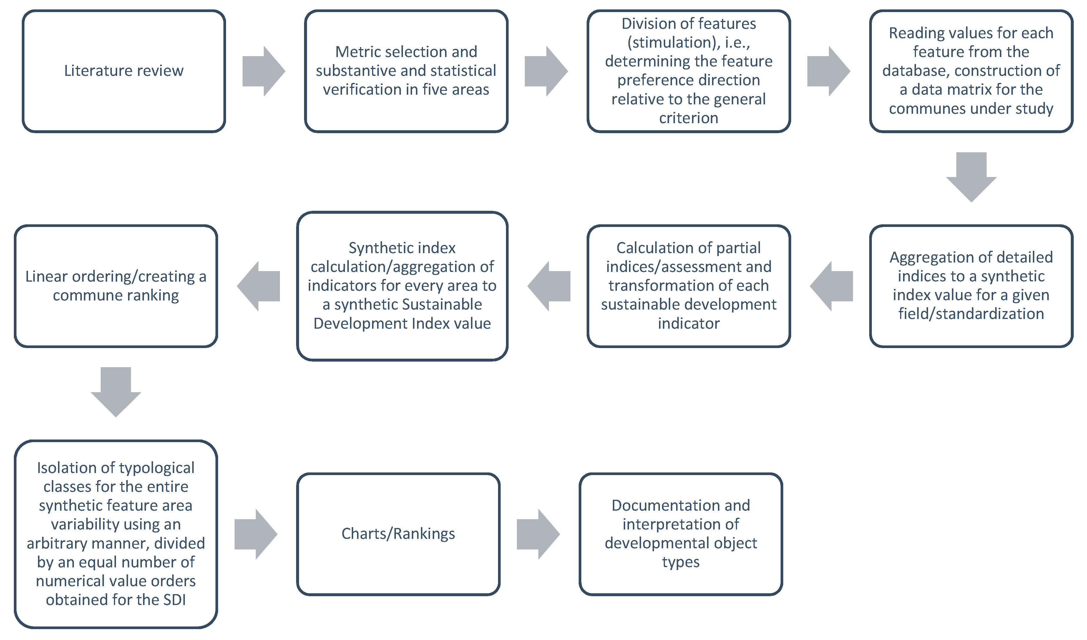
3.4. Sustainable Development Index (SDI) Calculation

Sustainable development is a dynamic process, and keeping it at a suitable level must be ensured by high ratings in each area from a spatial and temporal perspective. Therefore, to evaluate the sustainability trend by individual communes, the index values for 2015 and 2020 were calculated based on the following procedures:
  • A set of detailed metrics was identified and then assigned to one of five areas (synthetics indices) of sustainable development: economy, society, environment and institutions, and spatial planning.
  • The data used to determine the detailed metric values was the Local Databank of the Statistics Poland (BDL GUS) for the years 2015 and 2020.
  • The impact of each metric was assessed either as a stimulant or an inhibitor. A metric was considered a stimulant when the SDI value increases along with the metric. In other words, a higher metric value corresponds to a higher level of sustainable development. The opposite is true for inhibitors—here, the higher the metric, the more detrimental its impact on the SDI.
  • All of the detailed measures were subjected to data aggregation, namely, standardization utilizing the following Formulas (1) and (2):
Stimulant:
t r j = c r j min c r j max c r j min c r j
Inhibitor:
t r j = max c r j c r j max c r j min c r j
where:
t r j —is the value of standardized detailed metric j for commune r,
c r j —is the value of metric characteristic j for commune r.
5.
A total of five area indices (partial indices) were calculated for each commune, using the arithmetic mean (3)–(7).
RG r = 1 5 j = 1 5 t r j
RS r = 1 9 j = 1 9 t r j
R Ś r = 1 4 j = 1 4 t r j
RI r = 1 5 j = 1 5 t r j
RP r = 1 11 j = 1 11 t r j
where:
RG r —is the index value in the economic development area for commune r,
RS r —is the index value in the social development area for commune r,
R Ś r —is the index value in the environmental development area for commune r,
RI r —is the index value in the institutional development area for commune r,
RP r —is the index value in the spatial planning development area for commune r.
A commune ranking was compiled based on the results for each area (Supplementary File S1).
6.
The SDI r ( 2015 ) and SDI r ( 2020 ) were calculated for each commune using the arithmetic mean of detailed metrics (8).
SDI r = 1 5 ( RG r + RS r + R Ś r + RI r + RP r )
7.
SDI change calculations between 2015 and 2020.
Afterwards, to calculate how communes adapted to achieving sustainable development goals, decreases or increases in the value of SDI r ( 2015 ) were calculated relative to the value of SDI r ( 2020 ) (9).
DZ r = SDI r ( 2020 ) SDI r ( 2015 ) SDI r ( 2015 )   ×   100
The changes in the SDI r values for each commune were expressed in percentages.
The procedure used to develop the proposed approach is presented in Figure 3.

4. Results

The results of the analysis indicate that the communes of the Podkarpackie Voivodeship display a diverse range of values at the sustainable development levels, but it was possible to detect a concentration of communes that stood out from the rest. In spatial terms, three commune concentration areas with higher SDI values could be easily observed. The first was the city of Rzeszów, the voivodeship’s capital, and the communes that surround it. The second development area was the communes located the furthest to the north, near the border with Slovakia and Ukraine, whose territories include naturally valuable areas such as national parks. The third area that stood out in space, but that was the smallest in terms of area, was the city of Krosno, with a few communes that showed values slightly lower than the topmost part of the ranking (Supplementary File S1). The results of the analysis described above will be presented as cartograms (in Figure 4, Figure 5 and Figure 6).

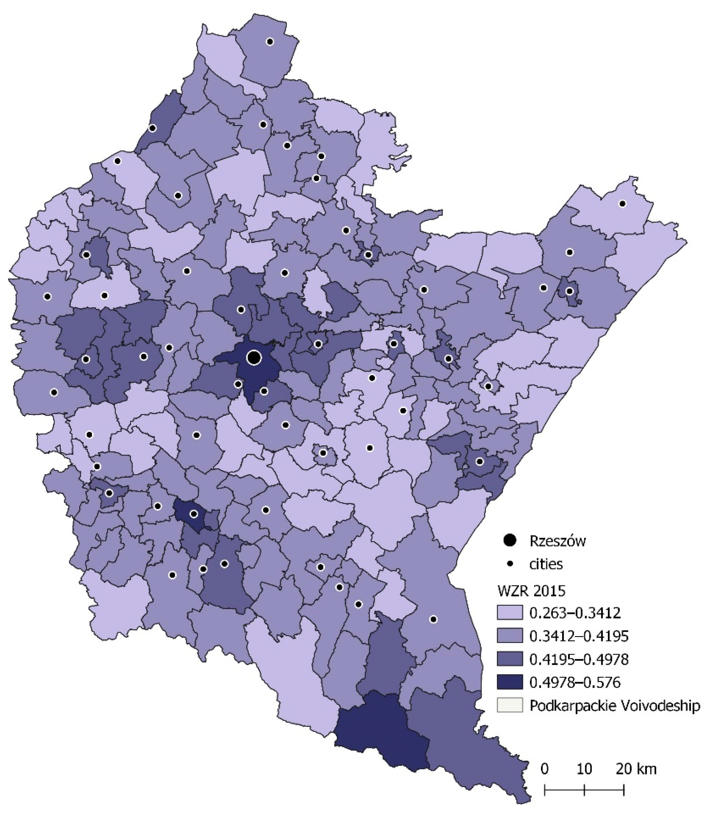
4.1. Sustainable Development Index 2015 and 2020

4.1.1. Sustainable Development Index 2015

  • The first 10 spots in the ranking were taken by rural–urban communes (Supplementary File S1, Figure 4)
  • The highest SDI value for 2015 belonged to Rzeszów (0.576), yet the rural commune of Cisna (0.573) and the urban commune of Krosno (0.570) had very similar readings.
  • Only these three communes had SDI values that exceeded 0.5. The communes that occupied the subsequent places in the rankings were the rural commune of Trzebownisko (0.493) and the urban communes of Jasło (0.493) and Łańcut (0.491). The top ten of the ranking also featured dynamically developing rural communes such as Solina (0.482), Krasne (0.480), Lutowiska (0.479), and Krościenko Wyżne (0.473).
  • A total of 47 communes attained SDI values ranging between 0.4 and 0.5, including bigger cities (urban communes) such as Jasło, Łańcut, Tarnobrzeg, Przemyśl, Leżajsk, Mielec, Dębica, Lubaczów, Przeworsk, Jarosław, Sanok, and Radymno. Rural–urban communes such as Głogów Małopolski, Boguchwała, Tyczyn, Rymanów, Ropczyce, Iwonicz Zdrój, and Jedlcze were also in this group.
  • The lowest SDI values belonged to the rural communes of Harasiuki, Nozdrzec, and Dynów, and amounted to 0.263, 0.278, and 0.281, respectively.

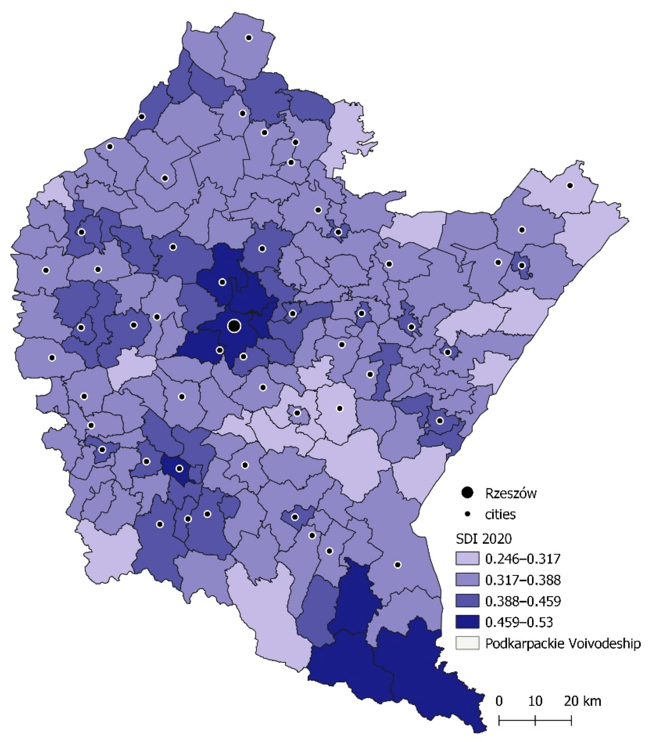
4.1.2. Sustainable Development Index 2020

  • Two rural–urban communes: Głogów Małopolski, which came fifth, and Boguchwała, which placed ninth, entered the top ten (Figure 5).
  • The top position in terms of SDI for 2020 was also held by Rzeszów (0.530), with the rural commune of Solina (0.523) coming second. The third place went to Krosno (0.514). Cisna fell from its second position from 2015 and placed fourth.
  • The top ten also included the rural–urban commune of Głogów Małopolski (0.491), the rural communes of Trzebownisko (0.479), Lutowiska (0.474), and Krasne (0.470), and the rural–urban commune of Boguchwała (0.461), which in 2015 placed fifteenth. Krościenko Wyżne and Łańcut fell out of the top ten, and placed twelfth and thirteenth in 2020, respectively.
  • In 2020, an SDI value of between 0.4 and 0.5 was attained by nine communes less than in 2015 (38). This group also featured the same cities as in 2015, namely, Łańcut, Tarnobrzeg, Mielec, Jasło, Lubaczów, Leżajsk, Sanok, Przeworsk, Dębica, Przemyśl, Radymno, and Jarosław, as well as the rural–urban communes of Głogów Małopolski, Boguchwała, Tyczyn, Rymanów, Iwonicz Zdrój, Jedlcze, and Kolbuszowa.

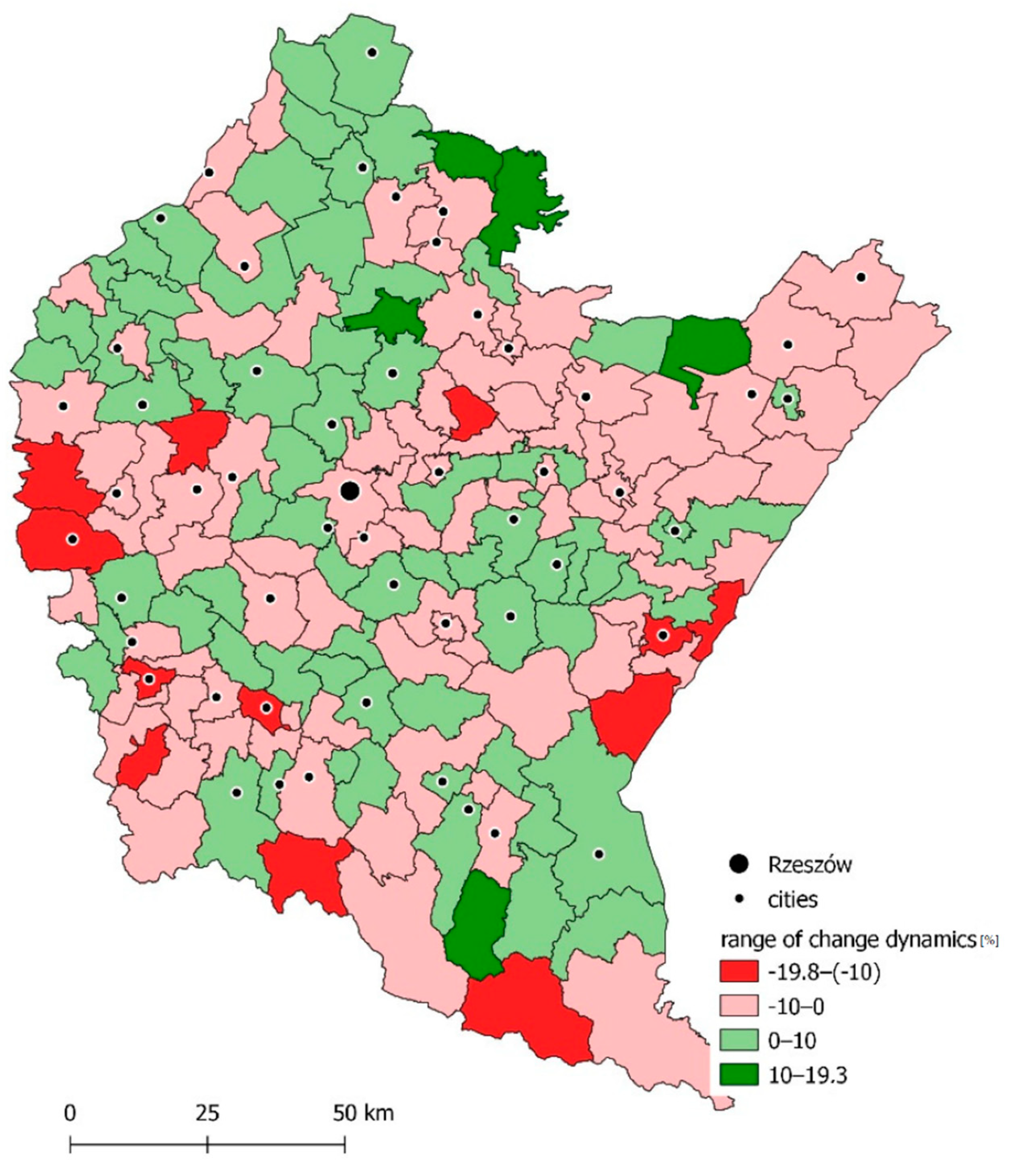
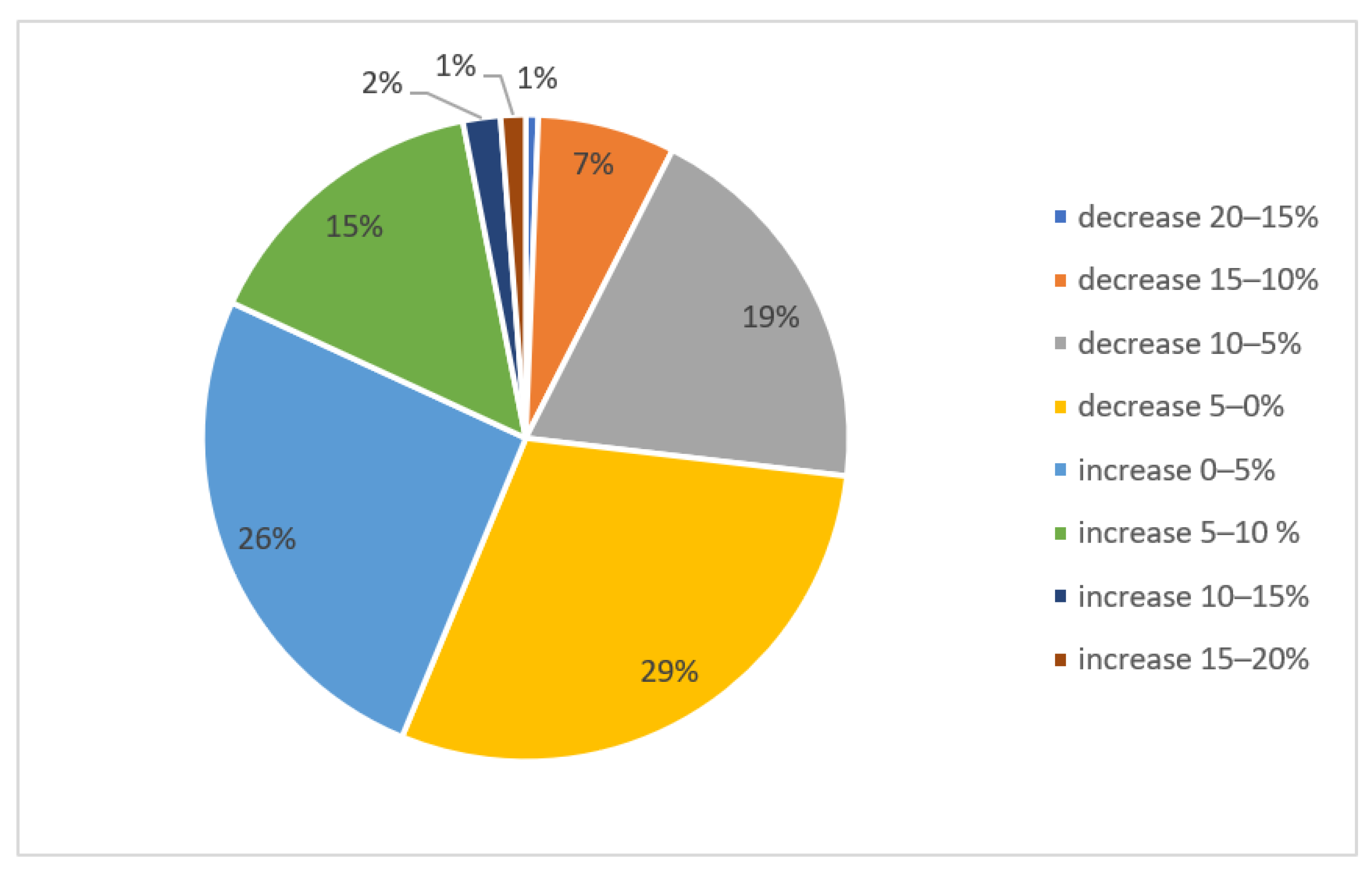
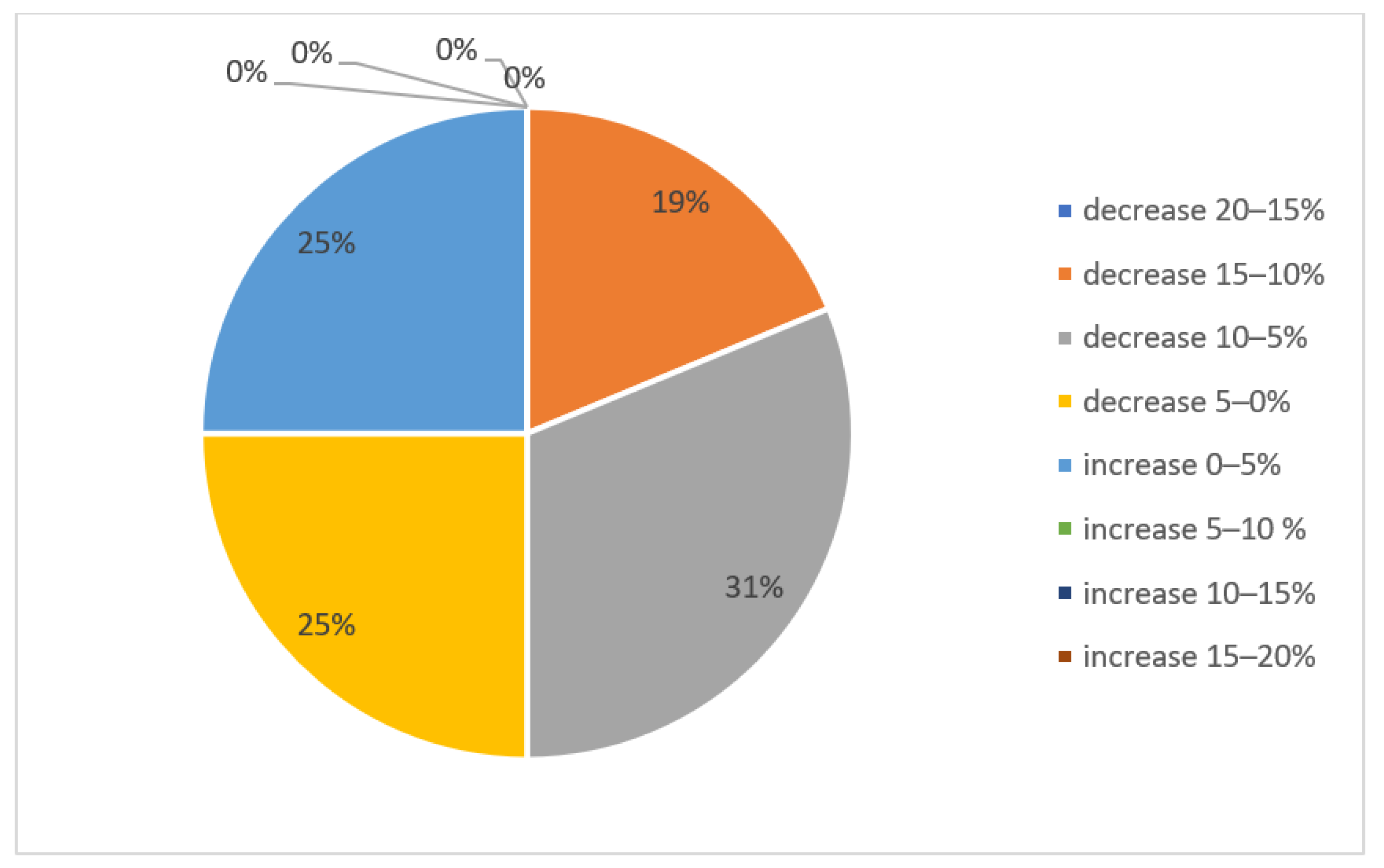
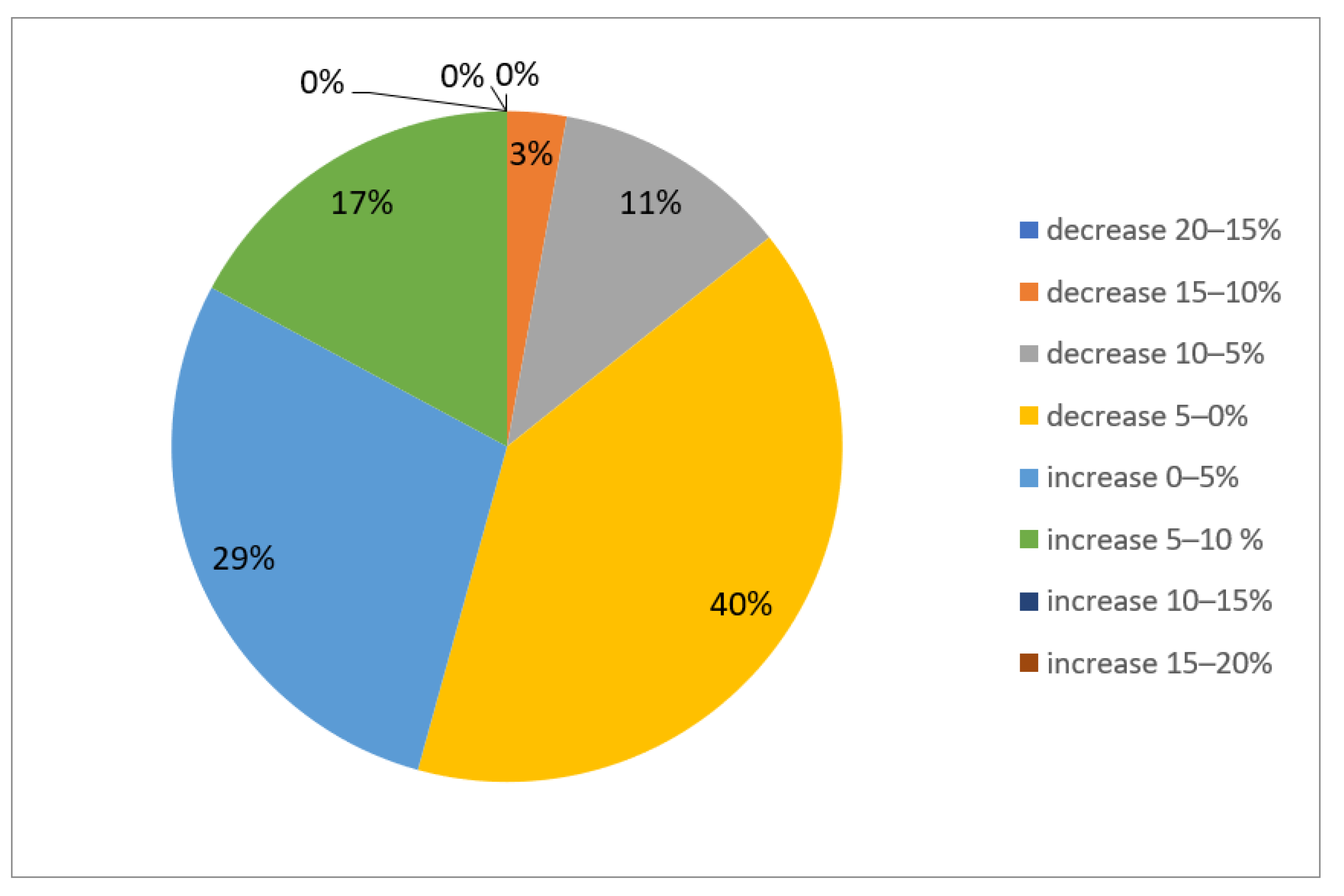
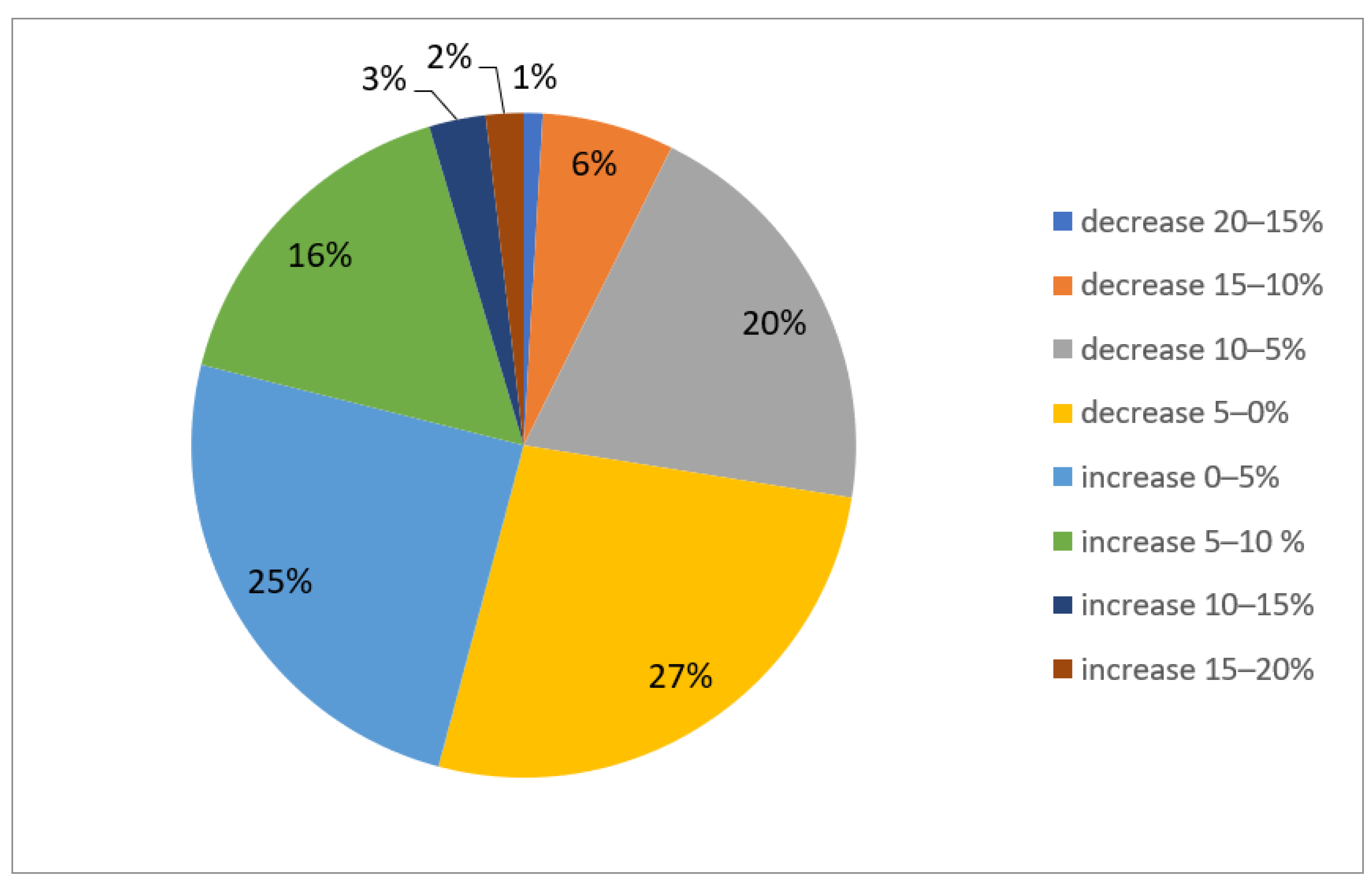
4.2. Change in Sustainable Development Index Values from 2015 to 2020

The analyzer in this study showed that SDIs for individual communes did not change significantly between 2015 and 2020. However, the increase in index values for individual subregions was highly diverse and most communes showed a small negative change. Positive values could be observed for about a dozen communes, with the change quite significant. This diversity shows the non-uniform development of the base territorial units of the voivodeship.
Overall, 70 communes registered an increase in SDI values, and this group included only four urban communes: Sanok, Stalowa Wola, Lubaczów, and Radymno, yet this increase was not high and was between 1.6 and 0.07% (Figure 6). The highest change dynamic, slightly over 19%, belonged to the rural community of Jarocin. Other rural communities with high growth included Baligród, Kamień, Harasiuki, and Stary Dzików, which registered changes of slightly more than 17% and slightly more than 10%. Only one urban commune, Próchnik, made it to the list of top ten communes whose SDI values increased. It is interesting that the second ten was also dominated by rural communities and featured only two rural–urban communes: Sokołów Małopolski and Przecław.
Between 2015 and 2020, the SDI value decreased in 90 communes (56% of all communes in the voivodeship’s communes). The largest SDI decrease was observed by the rural commune of Fredropol, whose rating for 2020 was almost 20% worse than in 2015. The rural communes of Jaśliska, Cisna, and Żołynia came next, with growth decreases of between 13 and 12%. The top ten communes with the highest SDI decreases included three urban communes: Przemyśl, Jasło, and Krosno. Rzeszów registered a decrease of 8.6% while the rural community of Łańcut noted a decrease of 6.8% (Supplementary File S1).

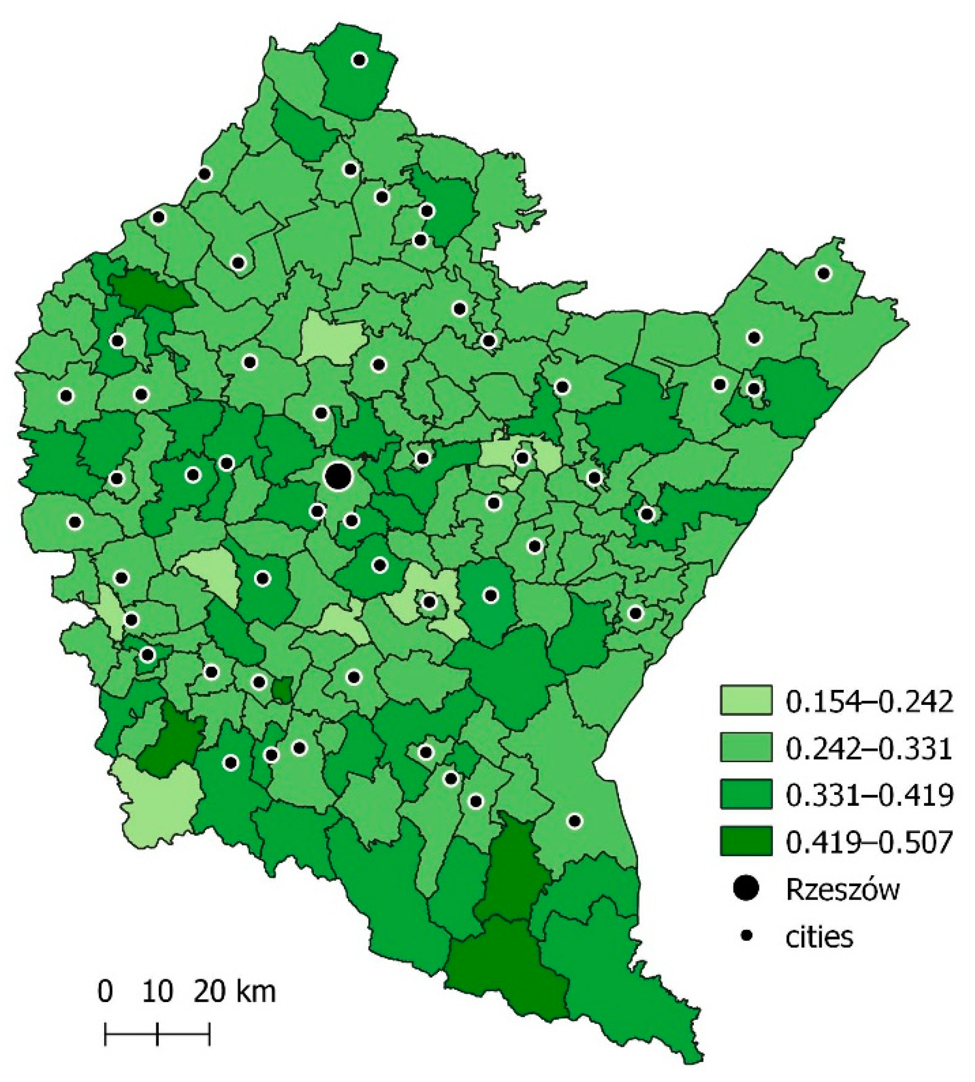
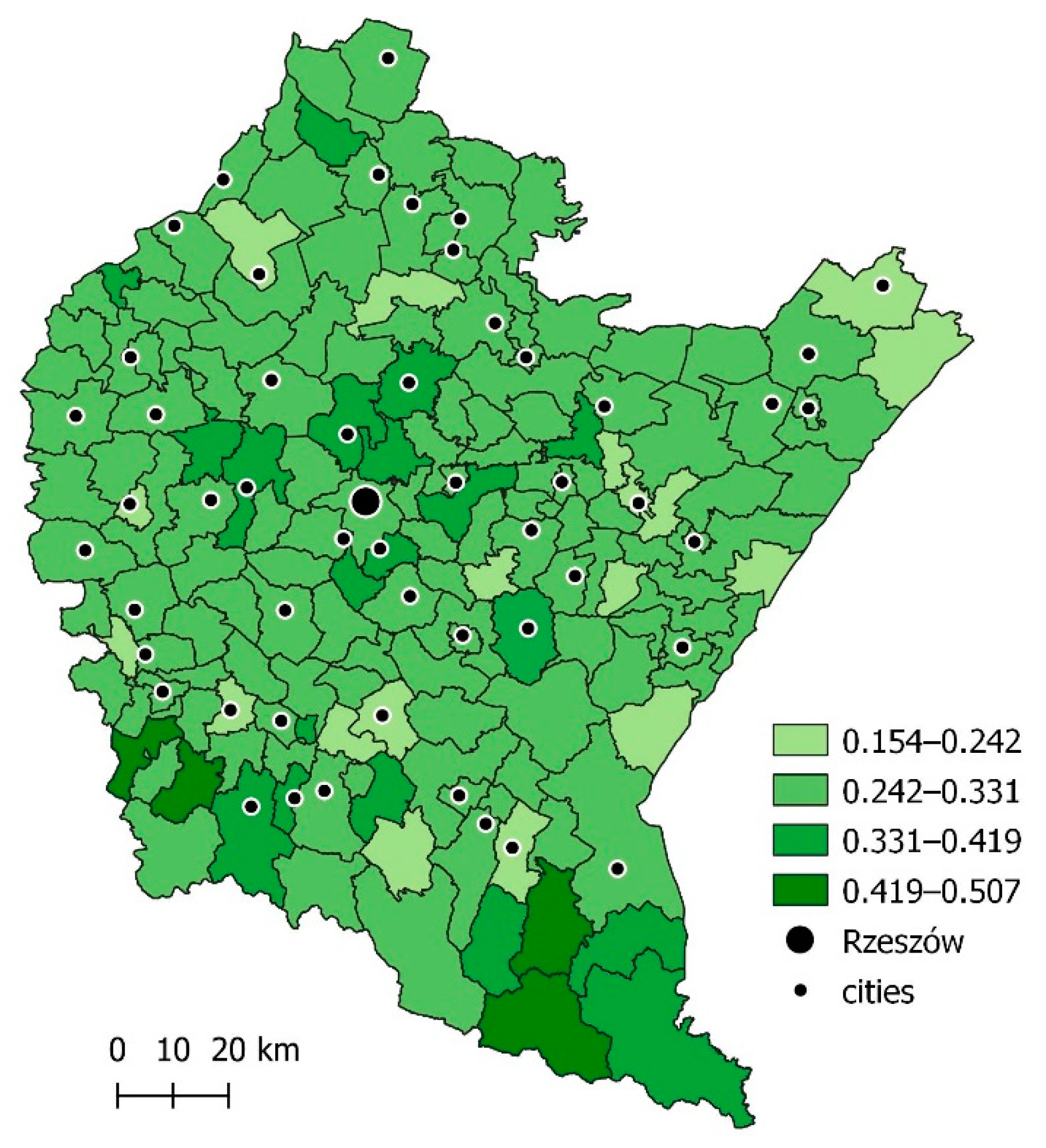
4.3. Sustainable Development in the Area of Spatial Planning in 2015 and 2020

The top ten communes ranked in terms of SDI in the field of spatial planning featured primarily rural communes (Supplementary File S1). In 2015, this group also featured one urban commune—Jasło—and one rural–urban commune—Tyczyn. In 2020, the top ten only included the rural–urban commune of Dukla (Figure 7 and Figure 8). The spatial diversity of the level of this component both in 2015 and 2020 showed no clear pattern.
The relative difference in SDI values that did not factor in spatial planning relative to those that did was up to 12% (Supplementary File S2). The greatest difference in values that did and did not factor in spatial planning was observed for small towns: Łańcut, Dębica, and Jarosław (Supplementary File S2). This indicates poorly conducted spatial planning in those areas and the lack of local spatial development plans, which was also observed during the study.

4.4. Sustainable Development Index by Commune Type

In general, it could be observed that only 44% of all communes increased their SDI values in 2020 compared to 2015. In 56% of the communes, this value decreased. For the highest number of communes, namely, 29%, this decrease was between −5% and 0% (Figure 9). It was interesting that the situation was similar in various types of communes. The highest decrease was observed in the case of urban communes. As much as 75% of the urban communes could neither maintain nor increase their SDI at the level from 2015 (Figure 10). In rural communes, 46% showed an increase in SDI and 54% showed a decrease (Figure 11). In the case of rural–urban communes, the values were similar—46% of these communes registered an increased SDI, while 56% showed a decrease (Figure 12).

5. Discussion and Conclusions

Calculating a Sustainable Development Index for five areas: economic, social, environmental, institutional, and spatial planning, can positively contribute to planning/urban design measures by identifying areas with different levels of sustainable development. The inclusion of the spatial planning area in the measurement of SDIs in this study is aligned with a theory supported by Polish and foreign researchers on the need to combine the principle of sustainable development with commune-level spatial policy [85,86,87].
The main objective of the research is to assess the actual level of progress of basic territorial units in implementing the principles of sustainable development in the Voivodeship of Podkarpackie. In this study, it was found that the Podkarpackie Voivodeship is an area whose individual communes display a varying degree of development. In many of them, a state of balance has not been achieved. The results of this study demonstrate that an increase in the value of the investigated sustainable development index was observed only in 67 of 160 communes of the voivodeship. This is only 44% and shows that the effectiveness of implementing sustainable development principles in the voivodeship is unsatisfactory. The low SDI values observed indicated that most communes required help in planning and managing sustainable development goals, and the proposed index can become an information and diagnostic tool that can facilitate the management of local-level development.
This study also confirmed that cities, including medium-sized cities such as Rzeszów, are catalysts for socioeconomic development and reach the highest SDI values. It was also found that certain rural–urban and rural communes are quite adept at conducting successful spatial policies directed towards achieving sustainable development goals, which resulted in a high SDI value and the increase of this value in 2020 relative to 2015. This is why the vast majority of communes should, following those most successful cases, change their approach to directing development.
The analysis of SDIs obtained at the local level allows for the spatial presentation of the context of the process of implementing sustainable development and the degree of its advancement at the voivodeship level. This, in turn, allows for directing action intended to improve the problems diagnosed in each of the sustainable development’s aspects in individual communes. This approach allows for accounting for local determinants of individual territorial units and to adapt initiatives depending on these individual needs and resources. Including local-level indicators in analyzing sustainable development opens up the possibility of monitoring the effects of initiatives or policies at the commune level. Referencing development goals and the potential to achieve them in each local government unit is a closer point of reference. This is especially crucial in the context of initiating action by the social groups and individuals that make up the community of a given commune.
The results of this study confirm the need to comprehensively assess the implementation of the principles of sustainable development in a comprehensive way. Economic development conditions an increase in the quality of life of residents and, thus, social development. It is important for development in economic and social spheres to be accompanied by a high level of metrics in the environmental area. This ensures that the development does not come at a cost to the natural environment. This factor is closely related to the spatial policy of a commune, as local planning documents have the greatest impact on the quality of spatial development due to their tactical/operational function.
In the process of conducting long-term coordinated spatial policy, it is important to not only formulate spatial development guidelines, but also devise instruments that can help the bodies of a commune take strategic action and present justification to other actors. The proposed sustainable development index that factors in spatial planning development can be such a tool. To meet these expectations, one should use various types of tools, including academic research presented in legible form. The findings of this study are one such approachable source of information that can be used by local governments, organizations, and local communities, as well as businesses, in implementing the goals of local policy and sustainable development. This includes, perhaps most importantly, its monitoring and actions leading to effective change in communes. Furthermore, research findings, including data comparisons and their graphical visualization set against an entire voivodeship, can become a valuable tool for dialogue between local authorities and citizens that can raise awareness and involvement in environmental protection, as well as educate and encourage pro-environmental behaviors.
It should be stressed that the additive aggregation used to calculate the sustainable development index has both strengths and weaknesses. Its strength is that one can include all areas/aspects of the economy, society, environment, and spatial planning in the SDI assessment, as well as the simplicity of performing calculations. Its weakness is that using additive aggregation means coming closer to weak sustainable development. This is why future analyses will use geometric aggregation, which is also for compensation in specific indicators. This approach would make it possible to factor in the relations between environmental and institutional development while assuming strong sustainable development.
At this stage of analysis, this research should be considered explorative and will be developed further in terms of its substantive content, research procedure, and the types of data used. During the further stages, the study will be enhanced on the basis of a more detailed data set collected from the databases of individual communes will be used. The final set of indices and metrics will be employed to study other voivodeships to obtain comparative material for other communes and regions within Poland. The study has limitations in that it was based on 2015 and 2020 and does not forecast future development trends for the communes under investigation. Enhancing the method to facilitate future trend modelling is a promising field for further study.

Supplementary Materials

The following supporting information can be downloaded at: https://www.mdpi.com/article/10.3390/su141610237/s1, Supplementary File S1: contains rankings of communes in terms of the Sustainable Development Index (SDI) in individual years and a ranking of communes in terms of development regarding spatial planning; Supplementary File S2: contains a ranking of municipalities in terms of the Sustainable Development Index (SDI), calculated without including the fifth area of Spatial Planning Development.

Author Contributions

Conceptualization, A.M. and D.J.; methodology, A.M. and I.S.; software, A.M.; validation, A.M. and I.S.; formal analysis, A.M., I.S. and D.J.; investigation, A.M. and D.J.; resources, A.M. and I.S.; data curation, A.M.; writing—original draft preparation, A.M. and D.J.; writing—review and editing, A.M. and I.S.; visualization, D.J.; supervision, A.M. and I.S.; project administration, A.M. and D.J.; funding acquisition, A.M. and D.J. All authors have read and agreed to the published version of the manuscript.

Funding

The publication was financed from the subsidy granted to the Cracow University of Economics and Rzeszów University of Technology.

Institutional Review Board Statement

Not applicable.

Informed Consent Statement

Not applicable.

Data Availability Statement

The data presented in this study are available on request from the corresponding author. The data are not publicly available due to the continuous research.

Conflicts of Interest

The authors declare no conflict of interest.

References

  1. Transforming Our World: The 2030 Agenda for Sustainable Development; United Nations, Department of Economic and Social Affairs, Sustainable Development: New York, NY, USA, 2016; Available online: https://sdgs.un.org/2030agenda (accessed on 16 July 2022).
  2. Doyle, T. Sustainable development and Agenda 21: The secular bible of global free markets and pluralist democracy. Third World Q. 1998, 19, 771–786. [Google Scholar] [CrossRef]
  3. Hametner, M.; Kostetckaia, M. Frontrunners and laggards: How fast Are the EU member states progressing towards the Sustainable Development Goals. Ecol. Econ. 2020, 177, 745623. [Google Scholar] [CrossRef]
  4. Dickens, C.; Smakhtin, V.; McCartney, M.; O’Brien, G.; Dahir, L. Defining and Quantifying National-Level Targets, Indicators and Benchmarks for Management of Natural Resources to Achieve the Sustainable Development Goals. Sustainability 2019, 11, 462. [Google Scholar] [CrossRef]
  5. Sustainable Development Goals (SDGs). Available online: https://www.un.org/sustainabledevelopment/sustainable-development-goals/ (accessed on 1 December 2021).
  6. Sustainable Development in the European Union—Monitoring Report on Progress towards the SDGs in an EU Context—2021 Edition. Available online: https://ec.europa.eu/eurostat/web/products-statistical-books/-/ks-03-21-096 (accessed on 20 February 2022).
  7. Miola, A.; Schiltz, F. Measuring sustainable development goals performance: How to monitor policy action in the 2030 Agenda implementation? Ecol. Econ. 2019, 164, 106373. [Google Scholar] [CrossRef] [PubMed]
  8. Kowalczyk, M. Zrównoważony rozwój miast na prawach powiatu w Polsce w świetle wybranych wskaźników środowiskowych. Zesz. Teor. Rachun. 2021, 112, 69–84. Available online: http://cejsh.icm.edu.pl/cejsh/element/bwmeta1.element.desklight-ed02aacf-b11d-41d4-8938-7f53d46d5f72/c/06_B5_Kowalczyk.pdf (accessed on 16 June 2022).
  9. OECD Regions and Cities at a Glance 2020. Available online: https://read.oecd.org/10.1787/959d5ba0-en?format=pdf (accessed on 18 December 2021).
  10. Chang, Y.; Fang, Z.; Hamori, S.; Chow, D.A. Sustainable Metropolis: Perspectives of Population, Productivity and Parity. Sustainability 2018, 10, 4264. [Google Scholar] [CrossRef]
  11. Sachs, J.; Kroll, C.; Lafortune, G.; Fuller, G.; Woelm, F. Sustainable Development Report 2021; Cambridge University Press: Cambridge, UK, 2021; Available online: https://www.sdgindex.org/reports/sustainable-development-report-2021/ (accessed on 16 June 2022).
  12. Resce, G.; Schiltz, F. Sustainable development in Europe: A multicriteria decision analysis. Rev. Income Wealth 2021, 67, 509–529. [Google Scholar] [CrossRef]
  13. Europe Sustainable Development Report 2021. Available online: https://eu-dashboards.sdgindex.org/ (accessed on 18 December 2021).
  14. Cieślak, I. Wieloaspektowa Analiza Konfliktów Przestrzennych, 1st ed.; Wydawnictwo Uniwersytetu Warmińsko-Mazurskiego: Olsztyn, Poland, 2020. [Google Scholar]
  15. Konstytucja Rzeczypospolitej Polskiej z Dnia 2 Kwietnia 1997. Available online: https://www.sejm.gov.pl/prawo/konst/polski/kon1.html (accessed on 18 December 2021).
  16. Ustawa z dnia 27 Kwietnia 2001 r. Prawo Ochrony Środowiska, Dziennik Ustaw 2001 Nr 62 Poz. 627. Available online: https://isap.sejm.gov.pl/ (accessed on 15 December 2021).
  17. Kampania 17 Celów. Available online: https://kampania17celow.pl/barometrwplywu/ (accessed on 30 August 2021).
  18. Adamowicz, M.; Smarzewska, A. Model oraz mierniki trwałego i zrównoważonego rozwoju obszarów wiejskich w ujęciu lokalnym. Finans. I Mark. 2009, 1, 251–269. Available online: https://sj.wne.sggw.pl/pdf/PEFIM_2009_n50_s251.pdf (accessed on 16 June 2022).
  19. Alaimo, L.; Maggino, F. Sustainable Development Goals Indicators at Territorial Level: Conceptual and Methodological Issues-The Italian Perspective. Soc. Indic. Res. 2020, 147, 383–419. [Google Scholar] [CrossRef]
  20. Jin, H.; Qian, X.; Chin, T.; Zhang, H. A Global Assessment of Sustainable Development Based on Modification of the Human Development Index via the Entropy Method. Sustainability 2020, 12, 3251. [Google Scholar] [CrossRef]
  21. Borychowski, C.; Staniszewski, J.; Zagierski, B. Problemy pomiaru rozwoju zrównoważonego na przykładzie wybranych wskaźników. Rocz. Ekon. Kujawsko-Pomorskiej. Szkoły Wyższej Bydg. 2016, 9, 28–43. Available online: http://cejsh.icm.edu.pl/cejsh/element/bwmeta1.element.desklight-4d96e6c9-26a9-46f0-8871-f04fd4b2b125 (accessed on 16 June 2022).
  22. Karahasanović, D.; Tatić, K.; Avdić, A. Sustainable Development Indicator with Special Focus on Developing Countries. Proposal of New Sustainable Development Index (Nsdi). Ann. Alexandru Ioan Cuza Univ. Econ. 2012, 59, 257–273. Available online: https://cyberleninka.org/article/n/1349759.pdf (accessed on 16 June 2022). [CrossRef]
  23. Mitchell, G. Problems and fundamentals of sustainable development indicators. Sustain. Dev. 1996, 4, 1–11. [Google Scholar] [CrossRef]
  24. Moldan, B.; Dahl, A. Challenges to Susstainability Indicators. In Sustainability Indicators: A Scientific Assessment; Hak, T., Moldan, B., Dahl, A., Eds.; Island Press: Washington, DC, USA, 2007; pp. 1–26. [Google Scholar]
  25. Eurostat. Sustainable Development Indicators. Available online: https://ec.europa.eu/eurostat/web/sdi/indicators (accessed on 20 April 2020).
  26. Sztumski, W. Refleksja na temat rozwoju zrównoważonego. (Czy rozwój zrównoważony jest fikcją, utopią, iluzją czy oszustwem?). Problemy Ekorozw. Probl. Sustain. Dev. 2008, 3, 133–139. Available online: http://yadda.icm.edu.pl/baztech/element/bwmeta1.element.baztech-article-BPL6-0009-0011 (accessed on 16 June 2022).
  27. Zacher, L. Trwały rozwój—utopia czy realna możliwość? Probl. Ekorozw. Probl. Sustain. Dev. 2008, 3, 63–68. [Google Scholar]
  28. Plechciak, A. Utopistyczny wymiar idei rozwoju zrównoważonego. Ann. Ethics Econ. Life 2011, 14, 91–100. Available online: http://cejsh.icm.edu.pl/cejsh/element/bwmeta1.element.hdl_11089_1384 (accessed on 16 June 2022).
  29. Czarnecki, B. Paradygmat zrównoważonego rozwoju kontra fajerwerki globalizacji. Archit. Artibus 2016, 8, 5–13. Available online: http://aeawa.pb.edu.pl/wp-content/uploads/2018/07/Architektura-2-2016-artykul-I.pdf (accessed on 16 June 2022).
  30. Bukrejewski, P.; Latawiec, A.; Matuszewska, A. Sustainable Development—Utopia or Implementation Possibilities? Probl. Ekorozw. Probl. Sustain. Dev. 2019, 14, 111–116. Available online: https://ekorozwoj.pollub.pl/index.php/number-1422019/sustainable-development-utopia-or-implementation-possibilities/ (accessed on 16 June 2022).
  31. Forestieri, G.; Marseglia, G.; Galiano, G. Recovery and optimization of the former railway transport track in an area of Sud Italy. WIT Trans. Built Environ. 2019, 186, 47–57. [Google Scholar] [CrossRef]
  32. Cook, J.; Oreskes, N.; Doran, P.T.; Anderegg, W.R.L.; Verheggen, B.; Maibach, E.W.; Carlton, J.S.; Lewandowsky, S.; Skuce, A.G.; Green, S.A.; et al. Consensus on consensus: A synthesis of consensus estimates on human-caused global warming. Environ. Res. Lett 2016, 11, 048002. [Google Scholar] [CrossRef]
  33. NASA. Global Climate Change. Available online: https://climate.nasa.gov/ (accessed on 1 April 2021).
  34. Climate. Available online: https://www.climate.gov/news-features/understanding-climate/climate-change-global-sea-level (accessed on 30 May 2021).
  35. Biłozor, A.; Cieślak, I. Review of Experience in Recent Studies on the Dynamics of Land Urbanisation. Land 2021, 10, 1117. [Google Scholar] [CrossRef]
  36. Dahl, A. Achievements and gaps in indicators for sustainability. Ecol. Indicat. 2012, 17, 14–19. [Google Scholar] [CrossRef]
  37. Shi, J.; Miao, W.; Si, H.; Liu, T. Urban Vitality Evaluation and Spatial Correlation Research: A Case Study from Shanghai, China. Land 2021, 10, 1195. [Google Scholar] [CrossRef]
  38. Gorzym-Wilkowski, W. Spatial planning as a tool for sustainable development. Polish realities. Barom. Regionalny. Anal. Progn. 2017, 15, 75–85. Available online: http://cejsh.icm.edu.pl/cejsh/element/bwmeta1.element.desklight-c6c7ab02-7a02-4f90-817b-076921093871 (accessed on 16 June 2022).
  39. Tuazon, D.; Corder, G.; McLellan, B. Sustainable development: A review of theoretical contributions. Int. J. Sustain. Future Hum. Secur. 2013, 1, 40–48. [Google Scholar] [CrossRef]
  40. Hodge, T. Towards a conceptual framework for assessing progress towards sustainability. Soc. Indic. Res. 1997, 40, 5–98. [Google Scholar] [CrossRef]
  41. Conceicao, P. Human Development Report 2020: The Next Frontier: Human Development and the Anthropocene; United Nations Development Programme: New York, NY, USA, 2020; Available online: https://hdr.undp.org/content/human-development-report-2020 (accessed on 18 July 2022).
  42. Pineda, J. Sustainability and human development: A proposal for a sustainability adjusted HDI (SHDI). Munich Pers. RePEc Arch. 2012, 37, 39656. Available online: https://mpra.ub.uni-muenchen.de/42636/ (accessed on 16 June 2022).
  43. Jain, P.; Jain, P. Sustainability assessment index: A strong sustainability approach to measure sustainable human development. Int. J. Sustain. Dev. World Ecol. 2013, 20, 116–122. Available online: https://www.tandfonline.com/doi/full/10.1080/13504509.2013.766910 (accessed on 16 June 2022). [CrossRef]
  44. Singh, R.; Murty, H.; Gupta, S.; Dikszit, A. An overview of sustainability assessment methodologies. Ecol. Indicat. 2009, 9, 189–212. [Google Scholar] [CrossRef]
  45. Bui, N.; Kawamura, A.; Amaguchi, H.; Bui, D.; Truong, N.; Nakagawa, K. Social sustainability assessment of groundwater resources: A case study of Hanoi, Vietnam. Ecol. Indicat. 2018, 93, 1034–1042. [Google Scholar] [CrossRef]
  46. Bui, N.; Kawamura, A.; Bui, D.; Amaguchi, H.; Bui, D.; Truong, N.; Do, H.; Nguyen, C. Groundwater sustainability assessment framework: A demonstration of environmental sustainability index for Hanoi, Vietnam. J. Environ. Manag. 2019, 241, 479–487. [Google Scholar] [CrossRef]
  47. Barrera-Roldán, A.; Saldívar-Valdés, A. Proposal and application of a Sustainable Development Index. Ecol. Indicat. 2002, 2, 251–256. [Google Scholar] [CrossRef]
  48. Hickel, J. The sustainable development index: Measuring the ecological efficiency of human development in the Anthropocene. Ecol. Econ. 2020, 167, 106331. [Google Scholar] [CrossRef]
  49. Wu, J. Landscape sustainability science: Ecosystem services and human well-being in changing landscapes. Landsc. Ecol. 2013, 28, 999–1023. [Google Scholar] [CrossRef]
  50. Pelenc, J.; Ballet, J. Strong sustainability, critical natural capital and the capability approach. Ecol. Econ. 2015, 112, 36–44. [Google Scholar] [CrossRef]
  51. Brand, F. Critical natural capital revisited: Ecological resilience and sustainable development. Ecol. Econ. 2009, 68, 605–612. [Google Scholar] [CrossRef]
  52. Patrício, J.; Elliott, M.; Mazik, K.; Papadopoulou, K.; Smith, C. DPSIR—Two decades of trying to develop a unifying framework for marine environmental management? Front. Mar. Sci. 2016, 3, 177. [Google Scholar] [CrossRef]
  53. Huang, L. Exploring the Strengths and Limits of Strong and Weak Sustainability Indicators: A Case Study of the Assessment of China’s Megacities with EF and GPI. Sustainability 2018, 10, 349. [Google Scholar] [CrossRef]
  54. Huang, L.; Wu, J.; Yan, L. Defining and measuring urban sustainability: A review of indicators. Landsc. Ecol. 2015, 30, 1175–1193. [Google Scholar] [CrossRef]
  55. Gan, X.; Fernandez, I.; Guo, J.; Wilson, M.; Zhao, Y.; Zhou, B.; Wu, J. When to use what: Methods for weighting and aggregating sustainability indicators. Ecol. Indicat. 2017, 81, 491–502. [Google Scholar] [CrossRef]
  56. Montgomery, M. The urban transformation of the developing world. Science 2008, 319, 761–764. [Google Scholar] [CrossRef]
  57. Prosperity of Cities: State of the World′s Cities 2012/2013; UN-Habitat: Nairobi, Kenya, 2012; Available online: https://unhabitat.org/prosperity-of-cities-state-of-the-worlds-cities-20122013 (accessed on 18 July 2022).
  58. Solecki, W.; Seto, K.; Marcotullio, P. It′s Time for an Urbanization Science. Environ. Sci. Policy Sustain. Dev. 2013, 55, 12–17. [Google Scholar] [CrossRef]
  59. Bettencourt, L.; West, G. A unified theory of urban living. Nature 2010, 467, 912–913. [Google Scholar] [CrossRef] [PubMed]
  60. Kennedy, C. The Evolution of Great World Cities: Urban Wealth and Economic Growth, 1st ed.; University of Toronto Press: Toronto, ON, Canada, 2011. [Google Scholar]
  61. Seto, K.; Reenberg, A.; Boone, C.; Fragkias, M.; Haase, D.; Langanke, T.; Marcotullio, P.; Munroe, D.; Olah, B.; Simon, D. Urban land teleconnections and sustainability. Proc. Natl. Acad. Sci. USA 2012, 109, 7687–7692. [Google Scholar] [CrossRef] [PubMed]
  62. Mundia, C.; Aniya, M. Dynamics of landuse/cover changes and degradation of Nairobi City, Kenya. Land Degrad Dev. 2006, 17, 97–108. [Google Scholar] [CrossRef]
  63. The Challenge of Slums—Global Report on Human Settlements 2003; UN-Habitat: Nairobi, Kenya, 2003; Available online: https://unhabitat.org/the-challenge-of-slums-global-report-on-human-settlements-2003 (accessed on 18 July 2022).
  64. Bolay, J. Slums and Urban Development: Questions on Society and Globalisation. Eur. J. Dev. Res. 2006, 18, 284–298. [Google Scholar] [CrossRef]
  65. Bloom, D.; Canning, D.; Fink, G. Urbanization and the wealth of nations. Science 2008, 319, 772–775. Available online: https://www.science.org/doi/10.1126/science.1153057 (accessed on 16 June 2022). [CrossRef]
  66. O′Hara, S. Urban development revisited: The role of neighborhood needs and local participation in urban revitalization. Rev. Soc. Econ. 2001, 59, 23–43. [Google Scholar] [CrossRef]
  67. Vishwanath, T.; Dowall, S.; Lozano-Gracia, D.; Sharma, N.; Wang, S.; Gun, H. Urbanization beyond Municipal Boundaries: Nurturing Metropolitan Economies and Connecting Peri-Urban Areas in India; World Bank: Washington, DC, USA, 2013; Available online: https://openknowledge.worldbank.org/handle/10986/13105 (accessed on 18 July 2022).
  68. Dykas, P. Taksonomiczne wskaźniki przestrzennego zróżnicowania rozwoju powiatów województwa podkarpackiego. Studia Prawno-Ekon. 2009, 80, 201–214. Available online: http://cejsh.icm.edu.pl/cejsh/element/bwmeta1.element.desklight-3af8e490-c35a-4578-bd71-a722e488d646 (accessed on 16 June 2022).
  69. Strojny, J. Wielowymiarowa analiza porównawcza województw: Podkarpackiego i małopolskiego. Przedsiębiorczość Eduk. 2016, 12, 68–84. [Google Scholar] [CrossRef]
  70. Hydzik, P. Zastosowanie metod taksonomicznych do oceny poziomu rozwoju społeczno-ekonomicznego powiatów województwa podkarpackiego. Humanit. Soc. Sci. 2012, 19, 17–32. [Google Scholar] [CrossRef]
  71. Pisarek, M.; Lechowska, J. Nowoczesne formy turystyki szansą zrównoważonego rozwoju obszarów wiejskich Podkarpacia. Woda-Sr. Obsz. Wiej. 2014, 14, 63–76. Available online: http://yadda.icm.edu.pl/baztech/element/bwmeta1.element.baztech-eeece9ae-b162-4b44-8935-dc8c2b004514 (accessed on 16 June 2022).
  72. Wosiek, M. Strukturalne uwarunkowania konkurencyjności regionów Polski Wschodniej w przestrzeni krajowej i europejskiej. Nierówności Społeczne Wzrost Gospod. 2010, 16, 388–402. Available online: https://www.ur.edu.pl/storage/file/core_files/2021/4/23/a3a1317031f7dfb8548de3e52255c4b6/31.pdf (accessed on 16 June 2022).
  73. Stec, M. Analiza porównawcza miar syntetycznych rozwoju społeczno-gospodarczego województw. Wiadomości Stat. 2007, 6, 51–58. Available online: https://www.ur.edu.pl/storage/file/core_files/2012/10/8/dcc5334718449a80e20580dcae198412/16.pdf (accessed on 16 June 2022).
  74. Stec, M. Dokładność Danych Statystycznych w Badaniach Zjawisk Złożonych. Wpływ na Wyniki Oceny Zrównoważonego Rozwoju Województw Polsk, 1st ed.; Wydawnictwo CeDeWu: Warsaw, Poland, 2021. [Google Scholar]
  75. Stec, M.; Janas, A. Analiza porównawcza metod klasyfikacji województw. Wiadomości Stat. 2009, 4, 26–41. Available online: http://bazekon.icm.edu.pl/bazekon/element/bwmeta1.element.ekon-element-000158468688 (accessed on 16 June 2022).
  76. Raport o Sytuacji Społeczno-Gospodarczej Województwa Podkarpackiego 2021, 1st ed; Urząd Statystyczny w Rzeszowie: Rzeszów, Poland, 2021. Available online: https://rzeszow.stat.gov.pl (accessed on 20 February 2022).
  77. Strategia Rozwoju Województwa—Podkarpackiego. 2020. Available online: https://www.rpo.podkarpackie.pl/index.php/dokumenty-strategiczne/285-strategia-rozwoju-wojewodztwa-podkarpackie-2020 (accessed on 20 May 2021).
  78. Samorząd Województwa Podkarpackiego. Available online: https://podkarpackie.pl/index.php/rozwoj-regionalny (accessed on 19 December 2021).
  79. Wskaźniki Zrównoważonego Rozwoju dla Polski. Katowic; Główny Urząd Statystyczny: Katowice, Poland, 2015. Available online: https://stat.gov.pl/files/gfx/portalinformacyjny/pl/defaultaktualnosci/5501/5/2/1/wzr_2015_-_publikacja.pdf (accessed on 18 December 2021).
  80. Zuziak, Z. Strategie Rewitalizacji Przestrzeni Śródmiejskiej, 1st ed.; Wydawnictwo Politechniki Krakowskiej: Kraków, Poland, 1998. [Google Scholar]
  81. Ossowicz, T. Urbanistyka Operacyjna. Zarys Teorii, 1st ed.; Oficyna Wydawnicza Politechniki Wrocławskiej: Wroclaw, Poland, 2019. [Google Scholar]
  82. Skrzypczak, I.; Kokoszka, W.; Zientek, D.; Tang, Y.; Kogut, J. Landslide Hazard Assessment Map as an Element Supporting Spatial Planning: The Flysch Carpathians Region Study. Remote Sens 2021, 13, 317. [Google Scholar] [CrossRef]
  83. Dziechciarz, J. Ekonometria. Metody, Przykłady, Zadania, 1st ed.; Wydawnictwo Akademii Ekonomicznej we Wrocławiu: Wrocław, Poland, 2003. [Google Scholar]
  84. Kukuła, K. Metoda unitaryzacji zerowanej na tle wybranych metod normowania cech diagnostycznych. Acta Sci. Acad. Ostroviensis 1999, 4, 5–31. Available online: https://bazhum.pl/bib/article/441529/ (accessed on 16 June 2022).
  85. Naess, P. Urban Planning and Sustainable Development. Eur. Plan. Stud. 2001, 9, 4. Available online: https://www.tandfonline.com/doi/abs/10.1080/713666490 (accessed on 16 June 2022). [CrossRef]
  86. Fuseini, I.; Kemp, J. A review of spatial planning in Ghana’s socio-economic development trajectory: A sustainable development perspective. Land Use Policy 2015, 47, 309–320. [Google Scholar] [CrossRef]
  87. Shen, Z.; Kawakami, M. Overview: Spatial Planning for Achieving Sustainable Urban Forms. In Spatial Planning and Sustainable Development, 3rd ed.; Shen, Z., Kawakami, M., Pai, J., Gao, X., Zhang, M., Eds.; Springer: Cham, Switzerland, 2015; pp. 1–14. [Google Scholar]
Figure 1. Territories of the Podkarpackie Voivodeship with the location of Rzeszów, against the rest of Europe. Source: original work.
Sustainability 14 10237 g001
Figure 2. Percentage of area with enforceable local spatial development plans in the overall area of voivodeships in Poland in 2015 and 2020. Source: GUS Local Data Bank, https://stat.gov.pl/ accessed on 16 June 2022.
Sustainability 14 10237 g002
Figure 3. Scheme of the research procedure: determination of the Sustainable Development Index (SDI) for the communes of Podkarpackie.
Sustainability 14 10237 g003
Figure 4. Cartogram showing the Sustainable Development Index for the communes of the Podkarpackie Voivodeship for 2015. Source: original work.
Sustainability 14 10237 g004
Figure 5. Cartogram showing the Sustainable Development Indicator of the communes of the Podkarpackie Voivodeship for 2020. Source: own study.
Sustainability 14 10237 g005
Figure 6. Cartogram showing the change in the Sustainable Development Index from 2015 to 2020 in the communes of the Voivodeship of Podkarpackie in %. Source: own study.
Sustainability 14 10237 g006
Figure 7. Cartogram showing the Sustainable Development in the area of spatial planning in 2015.
Sustainability 14 10237 g007
Figure 8. Cartogram showing the Sustainable Development in the area of spatial planning in 2020.
Sustainability 14 10237 g008
Figure 9. Change in the value of the Sustainable Development Index (SDI) from 2015 to 2020, percentage view—all types of communes (160 units).
Sustainability 14 10237 g009
Figure 10. Change in the value of the Sustainable Development Index (SDI) from 2015 to 2020, percentage view—urban communes (16 units).
Sustainability 14 10237 g010
Figure 11. Change in the value of the Sustainable Development Index (SDI) from 2015 to 2020, percentage view—rural communes (35 units).
Sustainability 14 10237 g011
Figure 12. Change in the value of the Sustainable Development Index (SDI) from 2015 to 2020, percentage view—rural–urban communes (109 units).
Sustainability 14 10237 g012
Table 1. Overview of the Podkarpackie Voivodeship. Source: own study based on the Local Data Bank, GUS, https://stat.gov.pl/ accessed on 16 June 2022.
Item No.Parameter TypePodkarpackie Voivodeship
20152020
1.Population (thousands)2127.62121.2
2.Territory (ha)1,784,5761,784,576
3.GDP (million PLN)70,57789,023
Table 2. Metrics and areas used in the Sustainable Development Index calculation procedure.
Synthetic Variable/Area of Sustainable DevelopmentMetrics Obtained from the Statistics PolandStimulant/Inhibitor
Economic Development (ED)Registered entities per 1000 inhabitantsStimulant
Entities recently registered in REGION per 1000 inhabitantsStimulant
Natural persons engaging in economic activity per 1000 inhabitantsStimulant
Reach of applying for environmental social aid in %Inhibitor
Budget of municipalities and cities with powiat rights per capitaStimulant
Social Development (SD)Natural growth per 1000 inhabitants in 2016Stimulant
Internal migration balance per 1000 inhabitantsStimulant
Retirement-age persons per 100 working-age personsInhibitor
Live births per 1000 inhabitantsStimulant
Deaths per 1000 inhabitantsInhibitor
Average dwelling usable floor area per personStimulant
Percentage of children aged 3–5 enrolled in kindergartenStimulant
Percentage of registered unemployed persons in working-age populationInhibitor
Healthcare consultations per capitaStimulant
Environmental Development (ED)Overall water consumption per capitaInhibitor
Percentage of sewerage users in populationStimulant
Gas utility users in populationStimulant
Municipal spending on air and climate protection per capitaStimulant
Institutional Development (ID)Municipal spending on education per capitaStimulant
Percentage of women among council membersStimulant
Foundations, associations and social organizations per 10 thousand inhabitantsStimulant
Percentage of spending on public roads in relation to general expenditureStimulant
Municipal spending on culture and national heritage preservation per capitaStimulant
Spatial Planning Development (SPD)Enforceable local spatial development plans as based on the Act of 7 July 1994, and the Act of 27 March 2003 per 10 thousand inhabitantsStimulant
Plans drafted based on the Act of 2003 per 10 thousand inhabitantsStimulant
Public project planning permits per 10 thousand inhabitantsStimulant
Planning permits for housing development per 10 thousand inhabitantsStimulant
Planning permits for commercial development per 10 thousand inhabitantsStimulant
Planning permits for other development per 10 thousand inhabitantsStimulant
Percentage of land assigned in a spatial development study for drafting a local spatial development plan Stimulant
Percentage of land assigned in a spatial development study for conversion into non-agricultural usesInhibitor
Percentage of land assigned in a spatial development study for conversion into non-forest usesInhibitor
Percentage of land in a municipality with enforceable local spatial development plansStimulant
Percentage of municipal territory with enforceable local spatial development plans based on the Act of 2003Stimulant
Publisher’s Note: MDPI stays neutral with regard to jurisdictional claims in published maps and institutional affiliations.

