
A Survey of GIS and AR Integration: Applications


Abstract
1. Introduction
2. AR and GIS Integration Use Cases
2.1. AR Map
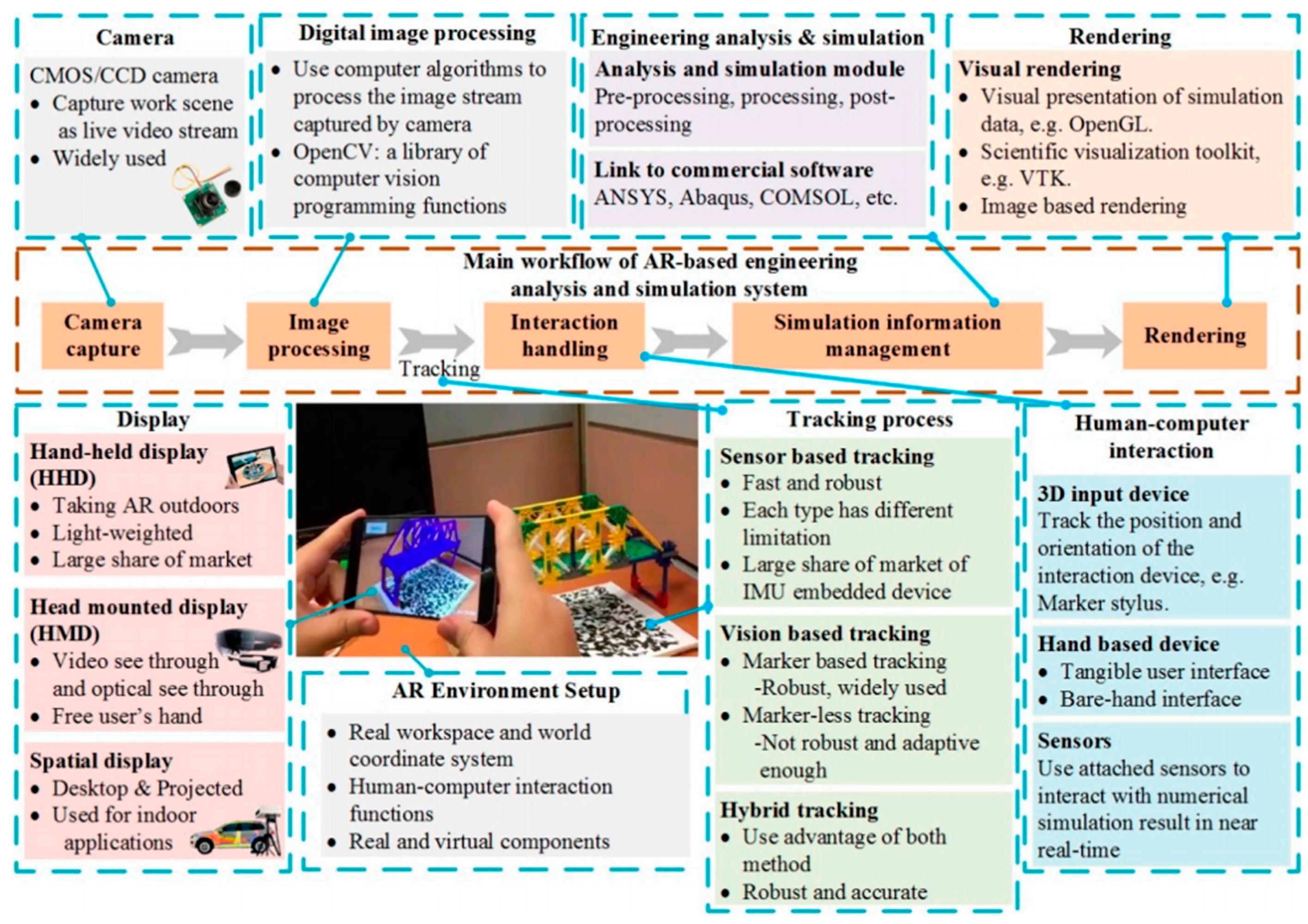
2.2. AR Analysis
2.3. AR Positioning
3. Discussion
4. Conclusions
Author Contributions
Funding
Institutional Review Board Statement
Informed Consent Statement
Data Availability Statement
Conflicts of Interest
References
- Kim, J.B. A personal identity annotation overlay system using a wearable computer for augmented reality. IEEE Trans. Consum. Electron. 2003, 49, 1457–1467. [Google Scholar] [CrossRef]
- Piekarski, W.; Thomas, B. ARQuake: The outdoor augmented reality gaming system. Commun. ACM 2002, 45, 36–38. [Google Scholar] [CrossRef]
- Panagiotakopoulos, D.; Dimitrantzou, K. Intelligent Ticket with Augmented Reality Applications for Archaeological Sites. In Strategic Innovative Marketing and Tourism; Springer: Rotterdam, The Netherlands, 2020; pp. 41–49. [Google Scholar] [CrossRef]
- Krajník, T.; Vonásek, V.; Fišer, D.; Faigl, J. AR-drone as a platform for robotic research and education. In Proceedings of the International Conference on Research and Education in Robotics, La Ferté-Bernard, France, 21–23 May 2009; pp. 172–186. [Google Scholar] [CrossRef]
- Ibáñez, M.-B.; Delgado-Kloos, C. Augmented reality for STEM learning: A systematic review. Comput. Educ. 2018, 123, 109–123. [Google Scholar] [CrossRef]
- Dini, G.; Dalle Mura, M. Application of augmented reality techniques in through-life engineering services. Procedia Cirp 2015, 38, 14–23. [Google Scholar] [CrossRef]
- tom Dieck, M.C.; Jung, T.H. Value of augmented reality at cultural heritage sites: A stakeholder approach. J. Destin. Mark. Manag. 2017, 6, 110–117. [Google Scholar] [CrossRef]
- Höllerer, T.; Feiner, S. Mobile Augmented Reality. Telegeoinformatics: Location-Based Computing and Services; Taylor and Francis: London, UK, 2004. [Google Scholar]
- Nincarean, D.; Alia, M.B.; Halim, N.D.A.; Rahman, M.H.A. Mobile Augmented Reality: The potential for education. Procedia-Soc. Behav. Sci. 2013, 103, 657–664. [Google Scholar] [CrossRef]
- Gibby, J.T.; Swenson, S.A.; Cvetko, S.; Rao, R.; Javan, R. Head-mounted display augmented reality to guide pedicle screw placement utilizing computed tomography. Int. J. Comput. Assist. Radiol. Surg. 2019, 14, 525–535. [Google Scholar] [CrossRef]
- Vitale, A. Viewing System for Augmented Reality Head Mounted Display. U.S. Patent Application No. 11/762,171, 18 December 2008. Available online: https://patents.google.com/patent/US20080309586 (accessed on 1 August 2022).
- Rauschnabel, P.A.; Brem, A.; Ivens, B.S. Who will buy smart glasses? Empirical results of two pre-market-entry studies on the role of personality in individual awareness and intended adoption of Google Glass wearables. Comput. Hum. Behav. 2015, 49, 635–647. [Google Scholar] [CrossRef]
- Mihelj, M.; Novak, D.; Beguš, S. Virtual Reality Technology and Applications; Intelligent Systems, Control and Automation: Science and Engineering (ISCA); Springer: Berlin/Heidelberg, Germany, 2014; Volume 67. [Google Scholar]
- Zhang, X.; Han, Y.; Hao, D.; Lv, Z. ARPPS: Augmented reality pipeline prospect system. In Proceedings of the International Conference on Neural Information Processing, New Delhi, India, 22–26 November 2022. [Google Scholar] [CrossRef]
- Huang, B.; Jiang, B.; Li, H. An integration of GIS, virtual reality and the Internet for visualization, analysis and exploration of spatial data. Int. J. Geogr. Inf. Sci. 2001, 15, 439–456. [Google Scholar] [CrossRef]
- Zhang, X.; Han, Y.; Hao, D.; Lv, Z. ARGIS-based outdoor underground pipeline information system. J. Vis. Commun. Image Represent. 2016, 40, 779–790. [Google Scholar] [CrossRef]
- Hugues, O.; Cieutat, J.-M.; Guitton, P. Gis and augmented reality: State of the art and issues. In Handbook of Augmented Reality; Springer: Rotterdam, The Netherlands, 2011; pp. 721–740. [Google Scholar] [CrossRef]
- Liarokapis, F.; Greatbatch, I.; Mountain, D.; Gunesh, A.; Brujic-Okretic, V.; Raper, J. Mobile augmented reality techniques for geovisualisation. In Proceedings of the Ninth International Conference on Information Visualisation (IV’05), London, UK, 6–8 July 2005. [Google Scholar] [CrossRef]
- Sakamoto, H.; Ishida, T. Proposal of a zoo navigation AR application using markerless image processing. In Proceedings of the International Conference on P2P, Parallel, Grid, Cloud and Internet Computing, Fukuoka, Japan, 28–30 October 2021. [Google Scholar] [CrossRef]
- Brata, K.C.; Liang, D.; Pramono, S.H. Location-based augmented reality information for bus route planning system. Int. J. Electr. Comput. Eng. 2015, 5, 142–149. [Google Scholar] [CrossRef]
- Kruijff, E.; Swan, J.E.; Feiner, S. Perceptual issues in augmented reality revisited. In Proceedings of the 2010 IEEE International Symposium on Mixed and Augmented Reality, Seoul, Korea, 13–16 October 2010. [Google Scholar] [CrossRef]
- Zollmann, S.; Schall, G.; Junghanns, S.; Reitmayr, G. Comprehensible and interactive visualizations of GIS data in augmented reality. In Proceedings of the International Symposium on Visual Computing, San Diego, CA, USA, 5–7 October 2020. [Google Scholar] [CrossRef]
- Čopič Pucihar, K.; Coulton, P.; Alexander, J. Evaluating dual-view perceptual issues in handheld augmented reality: Device vs. user perspective rendering. In Proceedings of the 15th ACM on International Conference on Multimodal Interaction, Sydney, Australia, 9–13 December 2013. [Google Scholar] [CrossRef]
- Drascic, D.; Milgram, P. Perceptual issues in augmented reality. In Proceedings of the Stereoscopic Displays and Virtual Reality Systems III, San Jose, CA, USA, 28 January–2 February 1996. [Google Scholar] [CrossRef]
- Peng, W.; Ward, M.O.; Rundensteiner, E.A. Clutter reduction in multi-dimensional data visualization using dimension reordering. In Proceedings of the IEEE Symposium on Information Visualization, Minneapolis, MN, USA, 23–25 October 2005. [Google Scholar] [CrossRef]
- Zollmann, S.; Poglitsch, C.; Ventura, J. VISGIS: Dynamic situated visualization for geographic information systems. In Proceedings of the 2016 International Conference on Image and Vision Computing New Zealand (IVCNZ), Palmerston North, New Zealand, 21–22 November 2016. [Google Scholar] [CrossRef]
- Wong, P.C.; Bergeron, R.D. Multiresolution multidimensional wavelet brushing. In Proceedings of the Seventh Annual IEEE Visualization’96, San Francisco, CA, USA, 27 October–1 November 1996. [Google Scholar] [CrossRef]
- Chen, C.-W.; Chen, W.-Z.; Peng, J.-W.; Cheng, B.-X.; Pan, T.-Y.; Kuo, H.-C.; Hu, M.-C. A real-time markerless augmented reality framework based on SLAM technique. In Proceedings of the 2017 14th International Symposium on Pervasive Systems, Algorithms and Networks & 2017 11th International Conference on Frontier of Computer Science and Technology & 2017 Third International Symposium of Creative Computing (ISPAN-FCST-ISCC), Exeter, UK, 21–23 June 2017. [Google Scholar] [CrossRef]
- Brashear, H.; Kim, J.S.; Lyons, K.; Starner, T.; Westeyn, T.; Lyons, K. GART: The Gesture and Activity Recognition Toolkit. Human-Comput. Interact 2007, 4552, 718–727. [Google Scholar] [CrossRef]
- Adithya, C.; Kowsik, K.; Namrata, D.; Nageli, V.; Shrivastava, S.; Rakshit, S. Augmented reality approach for paper map visualization. In Proceedings of the 2010 International Conference on Communication and Computational Intelligence (INCOCCI), Erode, India, 27–29 December 2010. [Google Scholar]
- Bobrich, J.; Otto, S. Augmented maps. Int. Arch. Photogramm. Remote Sens. Spat. Inf. Sci. 2002, 34, 502–505. [Google Scholar]
- Morrison, A.; Oulasvirta, A.; Peltonen, P.; Lemmela, S.; Jacucci, G.; Reitmayr, G.; Näsänen, J.; Juustila, A. Like bees around the hive: A comparative study of a mobile augmented reality map. In Proceedings of the SIGCHI Conference on Human Factors in Computing Systems, Paris, France, 27 April–2 May 2013. [Google Scholar] [CrossRef]
- Zhou, B.; Gu, Z.; Ma, W.; Liu, X. Integrated BLE and PDR Indoor Localization for Geo-Visualization Mobile Augmented Reality. In Proceedings of the 2020 16th International Conference on Control, Automation, Robotics and Vision (ICARCV), Shenzhen, China, 13–15 December 2020. [Google Scholar] [CrossRef]
- Braun, N. Storytelling in Collaborative Augmented Reality Environments. WSCG, Czech Republic. 2003. Available online: https://www.semanticscholar.org/paper/Storytelling-in-Collaborative-Augmented-Reality-Braun/f0163b2c5d7d53780b584207487bb81fa688012e (accessed on 28 June 2022).
- Feiner, S.; MacIntyre, B.; Höllerer, T.; Webster, A. A touring machine: Prototyping 3D mobile augmented reality systems for exploring the urban environment. Pers. Technol. 1997, 1, 208–217. [Google Scholar] [CrossRef]
- Kerski, J.J. Geo-awareness, geo-enablement, geotechnologies, citizen science, and storytelling: Geography on the world stage. Geogr. Compass 2015, 9, 14–26. [Google Scholar] [CrossRef]
- Zünd, F. Augmented Reality Storytelling; ETH Zurich: Zürich, Switzerland, 2016. [Google Scholar] [CrossRef]
- Savova, D. AR Sandbox in Educational Programs For Disaster. In Proceedings of the 6th International Conference on Cartography and GIS, Albena, Bulgaria, 13–17 June 2016. [Google Scholar]
- Afrooz, A.; Ballal, H.; Pettit, C. Implementing augmented reality sandbox in geodesign: A future for geodesign. ISPRS Ann. Photogramm. Remote Sens. Spat. Inf. Sci. 2018, 4. [Google Scholar] [CrossRef]
- Naps, T.; Cooper, S.; Koldehofe, B.; Leska, C.; Rößling, G.; Dann, W.; Korhonen, A.; Malmi, L.; Rantakokko, J.; Ross, R.J. Evaluating the educational impact of visualization. Acm Sigcse Bull. 2003, 35, 124–136. [Google Scholar] [CrossRef]
- Gilbert, J.K. Visualization: A metacognitive skill in science and science education. In Visualization in Science Education; Springer: Berlin/Heidelberg, Germany, 2005; pp. 9–27. [Google Scholar] [CrossRef]
- Kundu, S.N.; Muhammad, N.; Sattar, F. Using the augmented reality sandbox for advanced learning in geoscience education. In Proceedings of the 2017 IEEE 6th International Conference on Teaching, Assessment, and Learning for Engineering (TALE), Hong Kong, China, 12–14 December 2017. [Google Scholar] [CrossRef]
- Giorgis, S.; Mahlen, N.; Anne, K. Instructor-led approach to integrating an augmented reality sandbox into a large-enrollment introductory geoscience course for nonmajors produces no gains. J. Geosci. Educ. 2017, 65, 283–291. [Google Scholar] [CrossRef]
- Han, D.-I.; Jung, T.; Gibson, A. Dublin AR: Implementing augmented reality in tourism. In Information and Communication Technologies in Tourism 2014; Springer: Berlin/Heidelberg, Germany, 2013; pp. 511–523. [Google Scholar]
- Cranmer, E.E.; tom Dieck, M.C.; Fountoulaki, P. Exploring the value of augmented reality for tourism. Tour. Manag. Perspect. 2020, 35, 100672. [Google Scholar] [CrossRef]
- Bednarczyk, M. The Use of Augmented Reality in Geomatics. In Proceedings of the 10th International Conference “Environmental Engineering”, Cairo, Egypt, 7–9 April 2020. [Google Scholar] [CrossRef]
- Lin, P.-J.; Kao, C.-C.; Lam, K.-H.; Tsai, I.-C. Design and implementation of a tourism system using mobile augmented reality and GIS technologies. In Proceedings of the 2nd International Conference on Intelligent Technologies and Engineering Systems (ICITES2013), Kaohsiung, Taiwan, 12–14 December 2013. [Google Scholar] [CrossRef]
- Rosman, A.N.; Samsudin, N.A.; Ismail, A.; Aripin, M.S.; Khalid, S.K.A. Augmented reality application for location finder guidance. Indones. J. Electr. Eng. Comput. Sci. 2019, 13, 1237–1242. [Google Scholar] [CrossRef]
- Daponte, P.; De Vito, L.; Picariello, F.; Riccio, M. State of the art and future developments of the Augmented Reality for measurement applications. Measurement 2014, 57, 53–70. [Google Scholar] [CrossRef]
- Li, W.; Nee, A.; Ong, S. A state-of-the-art review of augmented reality in engineering analysis and simulation. Multimodal Technol. Interact. 2017, 1, 17. [Google Scholar] [CrossRef]
- Youm, D.; Seo, S.; Kim, J.-Y. Design and development methodologies of Kkongalmon, a location-based augmented reality game using mobile geographic information. EURASIP J. Image Video Process. 2019, 2019, 1. [Google Scholar] [CrossRef]
- Zhou, F.; Duh, H.B.-L.; Billinghurst, M. Trends in augmented reality tracking, interaction and display: A review of ten years of ISMAR. In Proceedings of the 2008 7th IEEE/ACM International Symposium on Mixed and Augmented Reality, Cambridge, UK, 15–18 September 2008. [Google Scholar] [CrossRef]
- Kumar, K.; Varghese, A.; Reddy, P.K.; Narendra, N.; Swamy, P.; Chandra, M.G.; Balamuralidhar, P. An improved tracking using IMU and vision fusion for mobile augmented reality applications. arXiv 2014, arXiv:1411.2335. [Google Scholar] [CrossRef]
- Fong, W.; Ong, S.-K.; Nee, A.Y. Computer vision centric hybrid tracking for augmented reality in outdoor urban environments. In Proceedings of the 8th International Conference on Virtual Reality Continuum and Its Applications in Industry, Brisbane, QLD, Australia, 14–16 November 2019. [Google Scholar] [CrossRef]
- Min, S.; Lei, L.; Wei, H.; Xiang, R. Interactive registration for Augmented Reality GIS. In Proceedings of the 2012 International Conference on Computer Vision in Remote Sensing, Xiamen, China, 16–18 December 2012. [Google Scholar] [CrossRef]
- Milosavljević, A.; Dimitrijević, A.; Rančić, D. GIS-augmented video surveillance. Int. J. Geogr. Inf. Sci. 2010, 24, 1415–1433. [Google Scholar] [CrossRef]
- Sweeney, M.W. Geographic information systems. Water Environ. Res. 1999, 71, 551–556. [Google Scholar] [CrossRef]
- Fenais, A.; Ariaratnam, S.T.; Ayer, S.K.; Smilovsky, N. Integrating geographic information systems and augmented reality for mapping underground utilities. Infrastructures 2019, 4, 60. [Google Scholar] [CrossRef]
- Kaddioui, A.; Shahrour, I.; El Oirrak, A. Uses of augmented reality for urban utilities management. MATEC Web Conf. 2019, 295, 8. [Google Scholar] [CrossRef]
- Stylianidis, E.; Valari, E.; Pagani, A.; Carrillo, I.; Kounoudes, A.; Michail, K.; Smagas, K. Augmented Reality Geovisualisation for Underground Utilities. Pfg-J. Photogramm. Remote Sens. Geoinf. Sci. 2020, 88, 173–185. [Google Scholar] [CrossRef]
- Luchetti, G.; Mancini, A.; Sturari, M.; Frontoni, E.; Zingaretti, P. Whistland: An augmented reality crowd-mapping system for civil protection and emergency management. ISPRS Int. J. Geo-Inf. 2017, 6, 41. [Google Scholar] [CrossRef]
- Guo, Y.; Du, Q.; Luo, Y.; Zhang, W.; Xu, L. Application of augmented reality GIS in architecture. ISPRS VIII 2008, 37, 331–336. [Google Scholar]
- Makino, R.; Yamamoto, K. Spatiotemporal information system using mixed reality for area-based learning and sightseeing. In Proceedings of the International Conference on Computers in Urban Planning and Urban Management, Bali, Indonesia, 14–15 January 2022. [Google Scholar] [CrossRef]
- Papadopoulou, E.-E.; Kasapakis, V.; Vasilakos, C.; Papakonstantinou, A.; Zouros, N.; Chroni, A.; Soulakellis, N. Geovisualization of the Excavation Process in the Lesvos Petrified Forest, Greece Using Augmented Reality. ISPRS Int. J. Geo-Inf. 2020, 9, 374. [Google Scholar] [CrossRef]
- Côté, S.; Trudel, P.; Desbiens, M.; Giguère, M.; Snyder, R. Live mobile panoramic high accuracy augmented reality for engineering and construction. In Proceedings of the 13th International Conference on Construction Applications of Virtual Reality, London, UK, 30–31 October 2013; pp. 1–10. [Google Scholar]
- Chi, H.-L.; Kang, S.-C.; Wang, X. Research trends and opportunities of augmented reality applications in architecture, engineering, and construction. Autom. Constr. 2013, 33, 116–122. [Google Scholar] [CrossRef]
- González, E.A.; Souvestre, F.; Benito, J.R.L. Augmented reality interface for E2LP: Assistance in electronic laboratories through augmented reality. In Embedded Engineering Education; Springer: Rotterdam, The Netherlands, 2016; pp. 93–108. [Google Scholar] [CrossRef]
- Kaufmann, H.; Meyer, B. Simulating educational physical experiments in augmented reality. In Proceedings of the ACM SIGGRAPH Asia 2008 Educators Programme, Singapore, 10–13 December 2008; pp. 1–8. [Google Scholar] [CrossRef]
- Yun, M.; Qimeng, N.; Fang, W.; Ying, L.; Haiyang, J. Application of augmented reality technology in industrial design. In Proceedings of the IOP Conference Series: Materials Science and Engineering, Luoyang, China, 17–19 May 2019. [Google Scholar]
- Kwiatek, C.; Sharif, M.; Li, S.; Haas, C.; Walbridge, S. Impact of augmented reality and spatial cognition on assembly in construction. Autom. Constr. 2019, 108, 102935. [Google Scholar] [CrossRef]
- Huang, J.; Ong, S.-K.; Nee, A.Y. Visualization and interaction of finite element analysis in augmented reality. Comput.-Aided Des. 2017, 84, 1–14. [Google Scholar] [CrossRef]
- Huang, J.; Ong, S.-K.; Nee, A.Y. Real-time finite element structural analysis in augmented reality. Adv. Eng. Softw. 2015, 87, 43–56. [Google Scholar] [CrossRef]
- Kashiyama, K.; Hamada, H.; Taniguchi, T. Large Scale Finite Element Simulation and Modeling using GIS/CAD for Environmental Flows in Urban Area. 2004. Available online: https://koreascience.kr/main.page (accessed on 29 June 2022).
- Naik, M.G.; Rao, E.; Eldho, T. Finite element method and GIS based distributed model for soil erosion and sediment yield in a watershed. Water Resour. Manag. 2009, 23, 553–579. [Google Scholar] [CrossRef]
- Xu, F.; Chen, X.; Ren, A.; Lu, X. Earthquake disaster simulation for an urban area, with GIS, CAD, FEA, and VR integration. Tsinghua Sci. Technol. 2008, 13, 311–316. [Google Scholar] [CrossRef]
- Hammad, A.; Garrett, J.; James, H.; Karimi, H.A. Potential of mobile augmented reality for infrastructure field tasks. In Proceedings of the 7th International Conference on 3D Web Technology, Tempe, AZ, USA, 24–28 February 2002; pp. 425–432. [Google Scholar] [CrossRef]
- Panou, C.; Ragia, L.; Dimelli, D.; Mania, K. An Architecture for Mobile Outdoors Augmented Reality for Cultural Heritage. ISPRS Int. J. Geo-Inf. 2018, 7, 463. [Google Scholar] [CrossRef]
- Riera, A.S.; Redondo, E.; Fonseca, D. Geo-located teaching using handheld augmented reality: Good practices to improve the motivation and qualifications of architecture students. Univers. Access Inf. Soc. 2015, 14, 363–374. [Google Scholar] [CrossRef]
- Specht, M.; Ternier, S.; Greller, W. Mobile augmented reality for learning: A case study. J. Res. Cent. Educ. Technol. 2011, 7, 117–127. [Google Scholar]
- Barthold, C.; Subbu, K.P.; Dantu, R. Evaluation of gyroscope-embedded mobile phones. In Proceedings of the 2011 IEEE International Conference on Systems, Man, and Cybernetics, Anchorage, AK, USA, 9–12 October 2011. [Google Scholar] [CrossRef]
- Piburn, J.; Morton, A. The Science Behind Pokemon GO; Oak Ridge National Lab. (ORNL): Oak Ridge, TN, USA, 2016. [Google Scholar]
- Huey, L.C.; Sebastian, P.; Drieberg, M. Augmented reality based indoor positioning navigation tool. In Proceedings of the 2011 IEEE Conference on Open Systems, Langkawi, Malaysia, 25–28 September 2011. [Google Scholar] [CrossRef]
- Zafari, F.; Gkelias, A.; Leung, K.K. A survey of indoor localization systems and technologies. IEEE Commun. Surv. Tutor. 2019, 21, 2568–2599. [Google Scholar] [CrossRef]
- Kim, J.; Jun, H. Vision-based location positioning using augmented reality for indoor navigation. IEEE Trans. Consum. Electron. 2008, 54, 954–962. [Google Scholar] [CrossRef]
- Joshi, R.; Hiwale, A.; Birajdar, S.; Gound, R. Indoor Navigation with Augmented Reality. In ICCCE 2019, Proceedings of the Proceedings of the 2nd International Conference on Communications and Cyber Physical Engineering, Pune, India, 1–2 February 2019; Springer: Berlin/Heidelberg, Germany, 2020; pp. 159–165. [Google Scholar] [CrossRef]
- Piekarski, W.; Thomas, B.H. Using ARToolKit for 3D hand position tracking in mobile outdoor environments. In Proceedings of the First IEEE International Workshop Agumented Reality Toolkit, Darmstadt, Germany, 29 September 2002. [Google Scholar] [CrossRef]
- Li, K.-J. Indoor space: A new notion of space. In Proceedings of the International Symposium on Web and Wireless Geographical Information Systems, Konstanz, Germany, 28–29 April 2022. [Google Scholar] [CrossRef]
- Deng, Z.; Yu, Y.; Yuan, X.; Wan, N.; Yang, L. Situation and development tendency of indoor positioning. China Commun. 2013, 10, 42–55. [Google Scholar] [CrossRef]
- Jamali, B.; Sadeghi-Niaraki, A.; Arasteh, R. Application of geospatial analysis and augmented reality visualization in indoor advertising. Int. J. Geogr. Geol. 2015, 4, 11–23. [Google Scholar] [CrossRef][Green Version]
- Polvi, J.; Taketomi, T.; Yamamoto, G.; Dey, A.; Sandor, C.; Kato, H. SlidAR: A 3D positioning method for SLAM-based handheld augmented reality. Comput. Graph. 2016, 55, 33–43. [Google Scholar] [CrossRef]
- Zendjebil, I.; Ababsa, F.-E.; Didier, J.-Y.; Vairon, J.; Frauciel, L.; Hachet, M.; Guitton, P.; Delmont, R. Outdoor Augmented Reality: State of the Art and Issues. In Proceedings of the 10th ACM/IEEE Virtual Reality International Conference (VRIC 2008), Laval, France, 4–8 April 2008; pp. 177–187. [Google Scholar]
- ÖZKUL, E.; KUMLU, S.T. Augmented reality applications in tourism. Int. J. Contemp. Tour. Res. 2019, 3, 107–122. [Google Scholar] [CrossRef]
- Ababsa, F.; Zendjebil, I.; Didier, J.-Y.; Pouderoux, J.; Vairon, J. Outdoor augmented reality system for geological applications. In Proceedings of the 2012 IEEE/ASME International Conference on Advanced Intelligent Mechatronics (AIM), Kaohsiung, Taiwan, 11–14 July 2012. [Google Scholar] [CrossRef]


Publisher’s Note: MDPI stays neutral with regard to jurisdictional claims in published maps and institutional affiliations. |
© 2022 by the authors. Licensee MDPI, Basel, Switzerland. This article is an open access article distributed under the terms and conditions of the Creative Commons Attribution (CC BY) license (https://creativecommons.org/licenses/by/4.0/).
Share and Cite
Safari Bazargani, J.; Zafari, M.; Sadeghi-Niaraki, A.; Choi, S.-M. A Survey of GIS and AR Integration: Applications. Sustainability 2022, 14, 10134. https://doi.org/10.3390/su141610134
Safari Bazargani J, Zafari M, Sadeghi-Niaraki A, Choi S-M. A Survey of GIS and AR Integration: Applications. Sustainability. 2022; 14(16):10134. https://doi.org/10.3390/su141610134
Chicago/Turabian StyleSafari Bazargani, Jalal, Mostafa Zafari, Abolghasem Sadeghi-Niaraki, and Soo-Mi Choi. 2022. "A Survey of GIS and AR Integration: Applications" Sustainability 14, no. 16: 10134. https://doi.org/10.3390/su141610134
APA StyleSafari Bazargani, J., Zafari, M., Sadeghi-Niaraki, A., & Choi, S.-M. (2022). A Survey of GIS and AR Integration: Applications. Sustainability, 14(16), 10134. https://doi.org/10.3390/su141610134