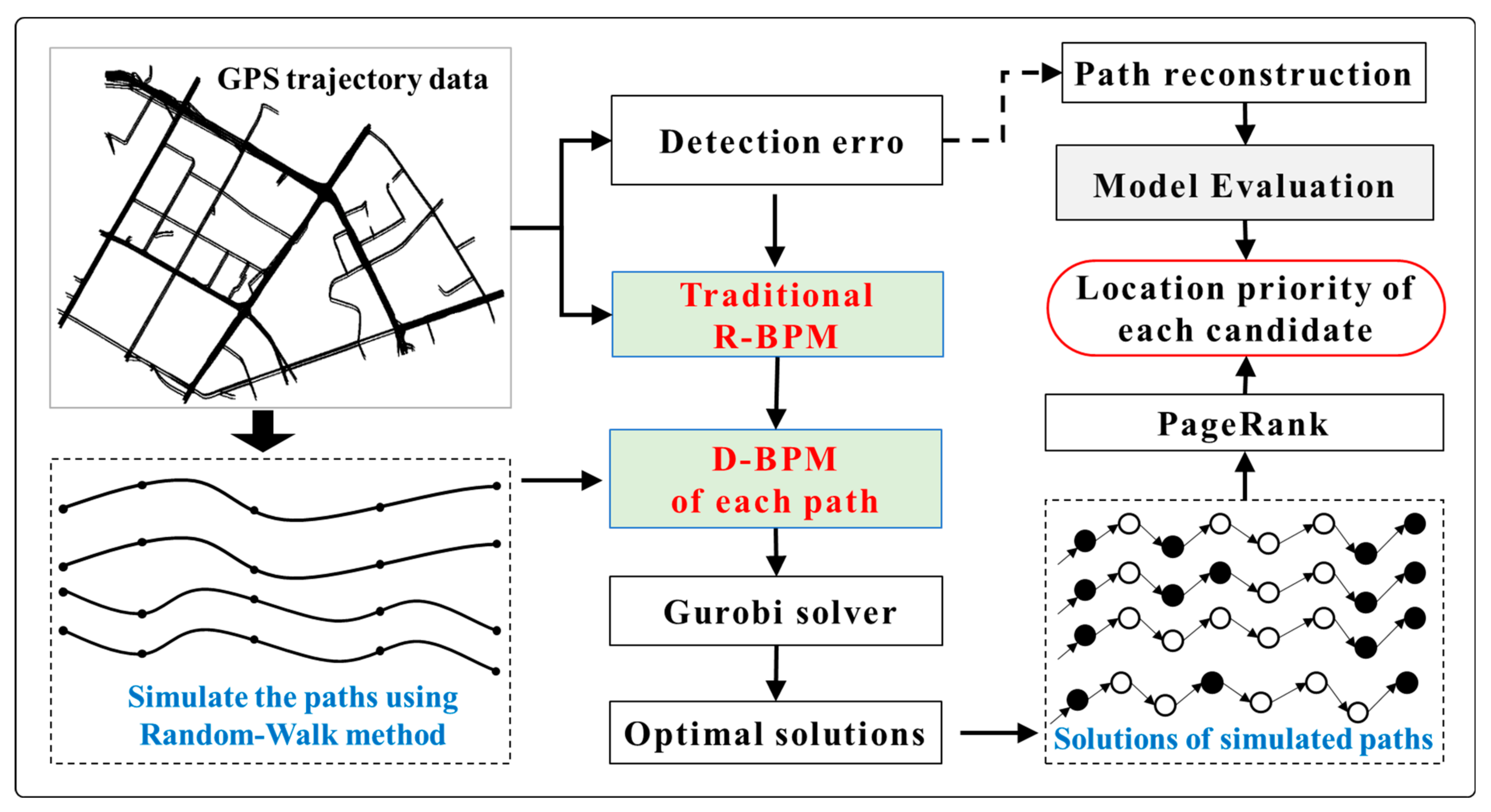
A Practical and Sustainable Approach to Determining the Deployment Priorities of Automatic Vehicle Identification Sensors

Abstract
1. Introduction
1.1. Background
1.2. Literature Review
1.3. Research Gaps and Contributions
2. Problem Description and Preliminaries
2.1. Problem Description and Assumptions
2.2. Preliminary Representation and Traditional Region-Level BPM
3. Model Formulation and Methodology
3.1. Random-Walk Method
3.1.1. Transferring Probability Calculation
3.1.2. Simulation Process
| Algorithm 1: The pseudo-code for the random walk | |
| Input: The surveyed OD matrix, observed trajectory data of the vehicles Output: The path set | |
| 1: | Initialization of and in , the length threshold |
| 2: | Calculate the transferring probability between each pair of nodes; |
| 3: | fordo |
| 4: | initialize to null and add into ; walking agent begins at ; ; |
| 5: | while the total length of does not exceed and the walking agent is not at do |
| 6: | select one of the agent’s adjacent nodes according to the |
| 7: | if is not a repeated or circular path do |
| 8: | add the selected adjacent node into ; |
| 9: | else do |
| 10: | select another one of the agent’s adjacent nodes according to the , return to line 7; |
| 11: | end if |
| 12: | let walking agent move to the last added node; |
| 13: | return |
| 14: | end for |
3.2. Formulating the P-BPM of Each Simulated Path
3.2.1. Problem Restatement
3.2.2. Formulating the P-BPM
3.3. Calculating the Deployment Score
4. Experiments
4.1. Dataset
4.2. Evaluation Methodology
4.2.1. Implementation Procedure
| Algorithm 2: The pseudo-code for inferring the whole detected path | |
| Input: The candidate graph , , and of each candidate node Output: | |
| 1: | Initialize and from the road map and , respectively |
| 2: | |
| 3: | for do |
| 4: | initialize from , = |
| 5: | for each segment from to in do |
| 6: | if is not adjacent to do |
| 7: | remove the path to from |
| 8: | remove the path to from |
| 9: | calculate the total value of the nodes in except and |
| 10: | calculate the total value of the nodes in except and |
| 11: | if do |
| 12: | insert to between and as |
| 13: | else do |
| 14: | insert to between and as |
| 15: | end if |
| 16: | end if |
| 17: | end for |
| 18: | return |
4.2.2. Performance Metrics
4.3. Experimental Results
4.4. Comparative Experiments
5. Conclusions and Discussions
Author Contributions
Funding
Data Availability Statement
Conflicts of Interest
Disclosure Statement
Variables
| Variables | Details |
| Binary, equal to 1 if there is an AVI sensor established at node , and 0 otherwise | |
| Binary, equal to 1 if the path from i to j within path r is misidentified, and 0 otherwise | |
| Integer, the misidentified traffic flow from node i to node j of path r | |
| Integer, the total true traffic flow of path r | |
| Float, the misidentified length from node i to node j path r | |
| Float, the total length ofpath r | |
| C | The set of candidate nodes, C |
| L | The set of links between the candidate nodes |
| R | The set of the total actual vehicle paths; each path is represented as a sequence of candidate nodes that the vehicle passes |
| The set of the nodes in path r, |
References
- Fu, C.; Sayed, T. Random-Parameter Bayesian Hierarchical Extreme Value Modeling Approach with Heterogeneity in Means and Variances for Traffic Conflict–Based Crash Estimation. J. Transp. Eng. Part A Syst. 2022, 148, 04022056. [Google Scholar] [CrossRef] [Scilit]
- Mahmud, S.; Day, C.M. Leveraging Data-Driven Traffic Management in Smart Cities: Datasets for Highway Traffic Monitoring. In The Rise of Smart Cities; Butterworth-Heinemann: Oxford, UK, 2022; pp. 583–607. [Google Scholar] [CrossRef] [Scilit]
- Fu, C.; Sayed, T. Bayesian dynamic extreme value modeling for conflict-based real-time safety analysis. Anal. Methods Accid. Res. 2022, 34, 100204. [Google Scholar] [CrossRef] [Scilit]
- Castillo, E.; Grande, Z.; Calviño, A.; Szeto, W.Y.; Lo, H.K. A state-of-the-art review of the sensor location, flow observability, estimation, and prediction problems in traffic networks. J. Sens. 2015, 2015, 903563. [Google Scholar] [CrossRef] [Scilit]
- Sharma, S.K.; Phan, H.; Lee, J. An Application Study on Road Surface Monitoring Using DTW Based Image Processing and Ultrasonic Sensors. Appl. Sci. 2020, 10, 4490. [Google Scholar] [CrossRef] [Scilit]
- Jo, Y.; Ryu, S. Pothole Detection System Using a Black-box Camera. Sensors 2015, 15, 29316–29331. [Google Scholar] [CrossRef] [Scilit] [PubMed]
- Asad, M.H.; Khaliq, S.; Yousaf, M.H.; Ullah, M.O.; Ahmad, A. Pothole Detection Using Deep Learning: A Real-Time and AI-on-the-Edge Perspective. Adv. Civ. Eng. 2022, 2022, 1–13. [Google Scholar] [CrossRef] [Scilit]
- Cao, Q.; Ren, G.; Li, D.; Ma, J.; Li, H. Semi-supervised route choice modeling with sparse Automatic vehicle identification data. Transp. Res. Part C Emerg. Technol. 2020, 121, 102857. [Google Scholar] [CrossRef] [Scilit]
- Gentili, M.; Mirchandani, P.B. Locating sensors on traffic networks: Models, challenges and research opportunities. Transp. Res. part C Emerg. Technol. 2012, 24, 227–255. [Google Scholar] [CrossRef] [Scilit]
- Chen, H.; Chu, Z.; Sun, C. Sensor Deployment Strategy and Traffic Demand Estimation with Multisource Data. Sustainability 2021, 13, 13057. [Google Scholar] [CrossRef] [Scilit]
- Fu, H.; Lam, W.H.; Shao, H.; Kattan, L.; Salari, M. Optimization of multi-type traffic sensor locations for estimation of multi-period origin-destination demands with covariance effects. Transp. Res. Part E Logist. Transp. Rev. 2021, 157, 102555. [Google Scholar] [CrossRef] [Scilit]
- Owais, M.; Moussa, G.S.; Hussain, K.F. Sensor location model for O/D estimation: Multi-criteria meta-heuristics approach. Oper. Res. Perspect. 2019, 6, 100100. [Google Scholar] [CrossRef] [Scilit]
- Zhu, N.; Fu, C.; Zhang, X.; Ma, S. A network sensor location problem for link flow observability and estimation. Eur. J. Oper. Res. 2022, 300, 428–448. [Google Scholar] [CrossRef] [Scilit]
- Gentili, M.; Mirchandani, P.B. Review of optimal sensor location models for travel time estimation. Transp. Res. Part C Emerg. Technol. 2018, 90, 74–96. [Google Scholar] [CrossRef] [Scilit]
- Gentili, M.; Mirchandani, P.B. Locating Active Sensors on Traffic Networks. Ann. Oper. Res. 2005, 136, 229–257. [Google Scholar] [CrossRef] [Scilit]
- Mínguez, R.; Sánchez-Cambronero, S.; Castillo, E.; Jiménez, P. Optimal traffic plate scanning location for OD trip matrix and route estimation in road networks. Transp. Res. Part B Methodol. 2010, 44, 282–298. [Google Scholar] [CrossRef] [Scilit]
- Castillo, E.; Menéndez, J.M.; Jiménez, P. Trip matrix and path flow reconstruction and estimation based on plate scanning and link observations. Transp. Res. Part B Methodol. 2008, 42, 455–481. [Google Scholar] [CrossRef] [Scilit]
- Zangui, M.; Yin, Y.; Lawphongpanich, S. Sensor location problems in path-differentiated congestion pricing. Transp. Res. Part C Emerg. Technol. 2015, 55, 217–230. [Google Scholar] [CrossRef] [Scilit]
- Cerrone, C.; Cerulli, R.; Gentili, M. Vehicle-ID sensor location for route flow recognition: Models and algorithms. Eur. J. Oper. Res. 2015, 247, 618–629. [Google Scholar] [CrossRef] [Scilit]
- Fu, C.; Zhu, N.; Ling, S.; Ma, S.; Huang, Y. Heterogeneous sensor location model for path reconstruction. Transp. Res. Part B Methodol. 2016, 91, 77–97. [Google Scholar] [CrossRef] [Scilit]
- Ruiz, C.; Conejo, A.J. Pool Strategy of a Producer With Endogenous Formation of Locational Marginal Prices. IEEE Trans. Power Syst. 2009, 24, 1855–1866. [Google Scholar] [CrossRef] [Scilit]
- Salari, M.; Kattan, L.; Gentili, M. Optimal roadside units location for path flow reconstruction in a connected vehicle environment. Transp. Res. Part C Emerg. Technol. 2022, 138, 103625. [Google Scholar] [CrossRef] [Scilit]
- Bianco, L.; Confessore, G.; Gentili, M. Combinatorial aspects of the sensor location problem. Ann. Oper. Res. 2006, 144, 201–234. [Google Scholar] [CrossRef] [Scilit]
- Gendreau, M.; Laporte, G.; Séguin, R. Stochastic vehicle routing. Eur. J. Oper. Res. 1996, 88, 3–12. [Google Scholar] [CrossRef] [Scilit]
- Owen, S.H.; Daskin, M.S. Strategic facility location: A review. Eur. J. Oper. Res. 1998, 111, 423–447. [Google Scholar] [CrossRef] [Scilit]
- Alves, M.J.; Antunes, C.H. A new exact method for linear bilevel problems with multiple objective functions at the lower level. Eur. J. Oper. Res. 2022, 303, 312–327. [Google Scholar] [CrossRef] [Scilit]
- Torres, J.J.; Li, C.; Apap, R.M.; Grossmann, I.E. A Review on the Performance of Linear and Mixed Integer Two-Stage Stochastic Programming Software. Algorithms 2022, 15, 103. [Google Scholar] [CrossRef] [Scilit]
- van Slyke, R.M.; Wets, R. L-shaped linear programs with applications to optimal control and stochastic programming. SIAM J. Appl. Math. 1969, 17, 638–663. [Google Scholar] [CrossRef] [Scilit]
- Benders, J.F. Partitioning procedures for solving mixed-variables programming problems. Comput. Manag. Sci. 2005, 2, 3–19. [Google Scholar] [CrossRef] [Scilit]
- Rubin, P.; Gentili, M. An exact method for locating counting sensors in flow observability problems. Transp. Res. Part C Emerg. Technol. 2021, 123, 102855. [Google Scholar] [CrossRef] [Scilit]
- Freeman, L.C. A Set of Measures of Centrality Based on Betweenness. Sociometry 1977, 40, 35–41. [Google Scholar] [CrossRef] [Scilit]
- Wu, X.; Cao, W.; Wang, J.; Zhang, Y.; Yang, W.; Liu, Y. A spatial interaction incorporated betweenness centrality measure. PLoS ONE 2022, 17, e0268203. [Google Scholar] [CrossRef] [Scilit] [PubMed]
- Wang, X.; Niu, S.; Gao, J.; Zhang, J. A Study on the Highway Network Key Segments Identifying Method Based on the Structural Characteristics. CICTP 2014, 2014, 1819–1829. [Google Scholar] [CrossRef] [Scilit]
- Trolliet, T.; Cohen, N.; Giroire, F.; Hogie, L.; Pérennes, S. Interest Clustering Coefficient: A New Metric for Directed Networks Like Twitter. J. Complex Netw. 2021, 10, 597–609. [Google Scholar] [CrossRef] [Scilit]
- Xuebin, W. Optimizing Bus Stop Locations in Wuhan, China; University of Twente Faculty of Geo-Information and Earth Observation (ITC): Enschede, The Netherlands, 2010. [Google Scholar]
- Gurobi Optimization LLC. Gurobi Optimizer Reference Manual. 2018. Available online: https://www.gurobi.com/documentation/9.5/refman/index.html (accessed on 2 July 2022).

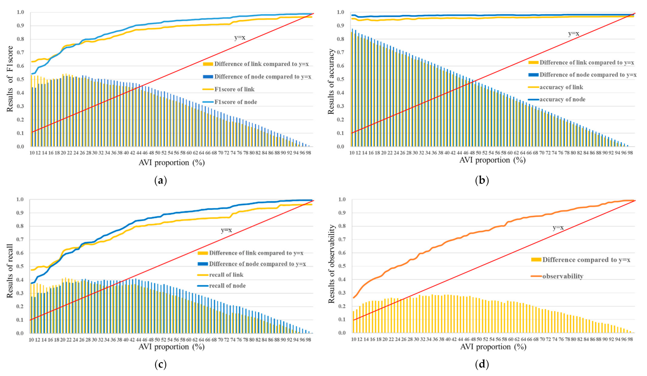
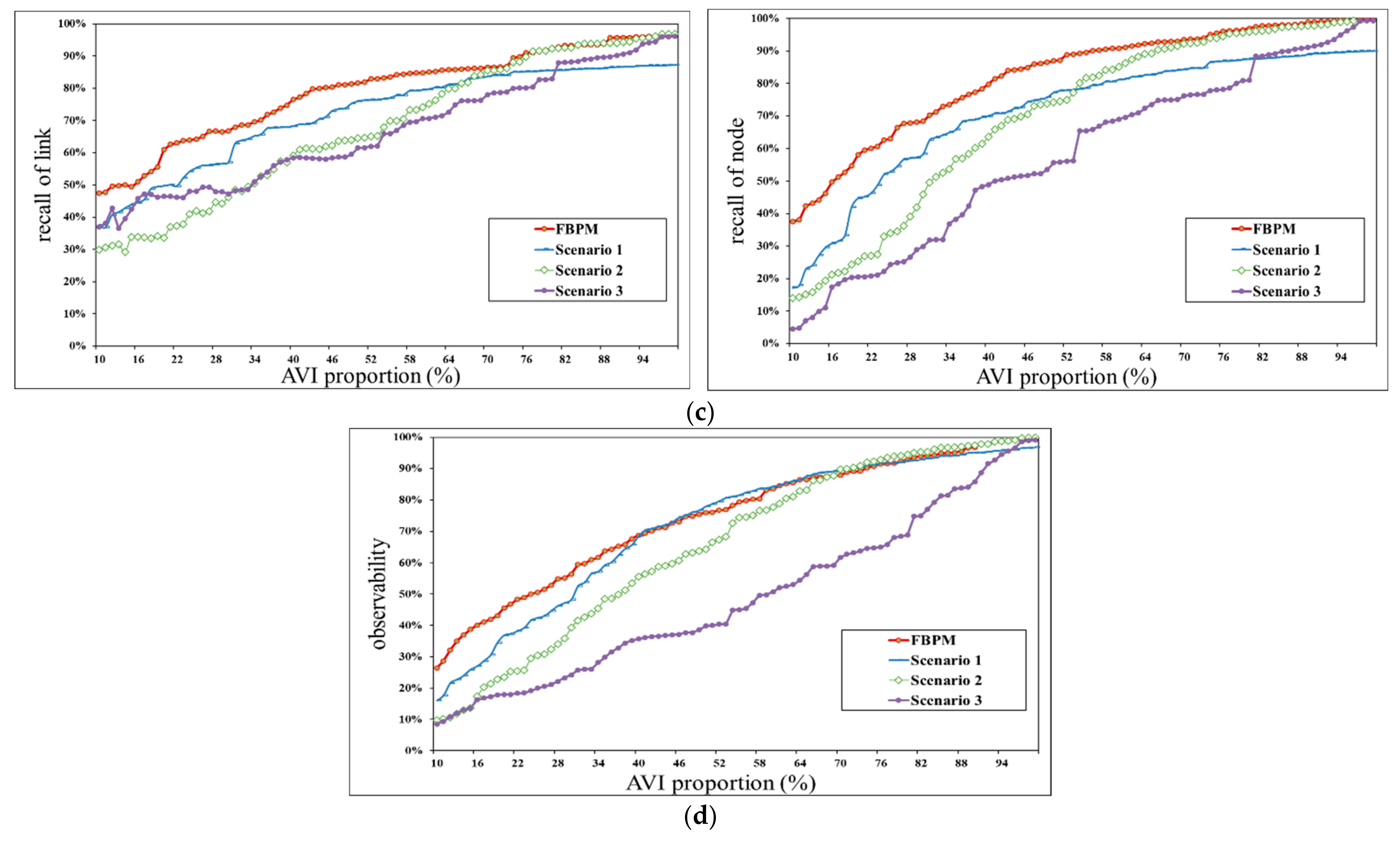

| Deployment Proportion of AVI Sensors | Link | Node | Observability | ||||
|---|---|---|---|---|---|---|---|
| 10% | 0.9521 | 0.4747 | 0.6335 | 0.9781 | 0.3753 | 0.5425 | 0.2638 |
| 20% | 0.9421 | 0.6092 | 0.7399 | 0.9697 | 0.5807 | 0.7264 | 0.4558 |
| 30% | 0.9485 | 0.668 | 0.7839 | 0.9712 | 0.6836 | 0.8024 | 0.5644 |
| 40% | 0.9572 | 0.7652 | 0.8505 | 0.9771 | 0.7979 | 0.8785 | 0.6878 |
| 50% | 0.9543 | 0.8164 | 0.88 | 0.9763 | 0.8693 | 0.9197 | 0.7599 |
| 60% | 0.9614 | 0.8483 | 0.9013 | 0.9788 | 0.9086 | 0.9424 | 0.8358 |
| 70% | 0.9632 | 0.8647 | 0.9113 | 0.9791 | 0.9347 | 0.9564 | 0.8788 |
| 80% | 0.967 | 0.9238 | 0.9449 | 0.9813 | 0.9695 | 0.9754 | 0.929 |
| 90% | 0.9679 | 0.9569 | 0.9624 | 0.9814 | 0.9893 | 0.9853 | 0.9685 |
Publisher’s Note: MDPI stays neutral with regard to jurisdictional claims in published maps and institutional affiliations. |
© 2022 by the authors. Licensee MDPI, Basel, Switzerland. This article is an open access article distributed under the terms and conditions of the Creative Commons Attribution (CC BY) license (https://creativecommons.org/licenses/by/4.0/).
Share and Cite
Li, D.; Wang, W.; Zhao, D. A Practical and Sustainable Approach to Determining the Deployment Priorities of Automatic Vehicle Identification Sensors. Sustainability 2022, 14, 9474. https://doi.org/10.3390/su14159474
Li D, Wang W, Zhao D. A Practical and Sustainable Approach to Determining the Deployment Priorities of Automatic Vehicle Identification Sensors. Sustainability. 2022; 14(15):9474. https://doi.org/10.3390/su14159474
Chicago/Turabian StyleLi, Dongya, Wei Wang, and De Zhao. 2022. "A Practical and Sustainable Approach to Determining the Deployment Priorities of Automatic Vehicle Identification Sensors" Sustainability 14, no. 15: 9474. https://doi.org/10.3390/su14159474
APA StyleLi, D., Wang, W., & Zhao, D. (2022). A Practical and Sustainable Approach to Determining the Deployment Priorities of Automatic Vehicle Identification Sensors. Sustainability, 14(15), 9474. https://doi.org/10.3390/su14159474