Article

Informal Settlement Resilience Upgrading-Approaches and Applications from a Cross-Country Perspective in Three Selected Metropolitan Regions of Southeast Asia

1
Department of Spatial Planning, TU Dortmund University, 44227 Dortmund, Germany
2
School of Urban and Regional Planning, University of the Philippines, Diliman, Quezon City 1101, Philippines
*
Authors to whom correspondence should be addressed.
Sustainability 2022, 14(15), 8985; https://doi.org/10.3390/su14158985
Submission received: 14 June 2022 / Revised: 13 July 2022 / Accepted: 20 July 2022 / Published: 22 July 2022

Abstract

:
Managing climate change is synonymous to managing cities and their growth. To shoulder the challenge of climate change adaptation, informal settlement upgrading in the global south has amounted to the importance of being attuned with the growth of its city and region at large. Changing the paradigm of on-site upgrading to being community-driven and city-led with domestic funding unlocks potentials for community resilience building, especially in countries that strive for inclusive growth. This research looks into informal settlement development dynamics and its resilience stance in conjunction of the metropolitan growth in three Southeast Asian countries. Greater Manila Area, Bangkok Metropolitan Region and Hanoi Capital Region serve as the backdrop for this investigation. The research mainly addresses informal settlement upgrading roles, mechanism and approaches for resilience building in these three metropolises, meanwhile also unveiling their city-regional development needs. The methodological approach of this study is highly participatory, demonstrating a hybrid of multi-spectrum stakeholder workshops, online surveys (due to COVID), expert interviews, project interim reports and correspondence with the local expert team in the three countries, etc. The paper attempts at providing a cross-country appraisal of the central strategies of informal settlement upgrading, related institutional constellations and upgrading applications along with the three metropolises’ urban development. This attempt accentuates the pressing needs of mitigating multi-facet vulnerability of informal communities, who are the most adversely affected by climate change and rampant urbanization. Further, this research will also reveal the mindset change of how decision-makers and the public contemplate upgrading objectives, e.g., recasting secure tenure instruments.

1. Introduction

The Sendai Framework for Disaster Risk Reduction point with Priority 4 on “Enhancing disaster preparedness for effective response and to “Build Back Better” in recovery, rehabilitation and reconstruction. Recovery, rehabilitation and reconstruction phase is a critical opportunity to “Build Back Better”, including through integrating disaster risk reduction into development measures, making nations and communities resilient to disasters. Here, land-use planning is regarded as an important actor: “(…) use opportunities during the recovery phase to develop capacities that reduce disaster risk in the short, medium and long term, including through the development of measures such as land-use planning (…)” [1] (p. 22).
The New Urban Agenda vows to “commit ourselves to strengthening the resilience of cities and human settlements, including through the development of quality infrastructure and spatial planning (…), especially in risk-prone areas of formal and informal settlements” [2] (p. 21). The Sustainable Development Goals 11 points with Target 11.5 at “a significant reducing of the number of deaths and the number of people affected and substantial decrease of the direct economic losses relative to global gross domestic product caused by disasters, including water-related disasters, with a focus on protecting the poor and people in vulnerable situations” [3].
Thus, the global policy agenda clearly identifies a need for action for resilience building. In this context, informal settlements are a key challenge. The risk factors are often related to their location in vulnerable areas, the susceptibility of the built environment, and the lack of resources of the inhabitants to protect themselves against the negative impacts of extreme events and adapt to climatic changes [4]. However, the main focus of related research activities and policy programs is on off-site relocation while less attention is spent to on-site activities [5].
Many research activities proofed the fact that managed (off-site) retreat initiatives have been often implemented in a top-down manner and have had a range of negative side effects for those relocated due to their relatedness from their place of living, dependency from informal labor markets and its accessibility [6,7].
However, any adaptation strategy is deeply embedded in a physical, but even more important, a cultural and legal-administrative setting. In order to explore the applicability of various approaches and applications for resilience upgrading of informal settlements, we compared three different metropolitan regions from three Asian countries which are highly at risk: metropolitan Manila, the Philippines, metropolitan Bangkok, Thailand and metropolitan Hanoi, Vietnam [8]. The research was conducted in context of the project LIRLAP “Linking disaster risk governance and land-use planning: the case of informal settlements in hazard prone areas in the Philippines, Thailand and Vietnam” which is part of the German funding initiative SURE—“Sustainable Development of Urban Regions”.
By doing so, we want to address the following research questions:
(1)
How the city-region spatial conditions and development look like in the three metropolis regions? What are the interactions of urban growth, informality, and informal settlements?
(2)
What are the central strategies regarding existing informal urbanization, informality, and proliferation of informal settlements?
(3)
What is the role of informal settlement on-site upgrading in terms of its integration with resiliency and disaster risk mitigation? (needs, gaps, and achievement, etc.)
(4)
How does climate change affect the management of upgrading informal settlements? Climate change alters exposure. Informal settlements that were not previously at risk may be in future.
(5)
How is the performance of on-site upgrading in conjunction with citywide development? (potentials and impediments; possible mechanisms/tools to promote on-site upgrading?)

2. Materials and Methods

The research methods were manifold. Primary data were collected through a guideline-based cross-country expert online survey (LimeSurvey), multi-stakeholder workshop series over the last two years in all three metropolitan areas and field work in selected informal settlements. The stakeholder workshop series has involved participants at multi-governance level including the national, regional and local government agencies, universities and research institutions experts (from the Philippines, Vietnam, Thailand, Indonesia and Germany), civil society and international organizations (UNHABITAT the Philippines, Asia Development Bank in Metro Manila, GIZ-German Corporation for International Cooperation GmbH the Philippines, etc.). Additional secondary data were extracted from resource persons, expert interviews and a desktop screening of relevant policy regulations and planning documents from all three countries. It expects that in this way, the collected data were triangulated and validated. In total, four cross-country multi-level stakeholder workshops from 2020–2021 dedicated to this paper, respectively in October 2020, November 2021, two workshops in July 2022. Specifically relevant to this paper:
(1)
There are two sets of online questionnaires, including both pre-workshop via LimeSurvey and a real-time Zoom polling with ca. 42 participants during the October 2020 workshop. Particularly need to mention, Indonesia was involved at the beginning of the research activities, e.g., in the workshops and online survey. The country has a good experience on informal settlement upgrading. Along with the research development, the project LIRLAP identifies its focus on the other three countries.
(2)
The questionnaire results were jointly discussed and validated during the workshop in November 2021. The thematic areas are (a) alternative land and housing tenure; and (b) application of land readjustment for citywide upgrading. This workshop was able to get four resource persons, who contributed to the thematic discussions on Metro Manila. Philippine participants included those from National Economic and Development Authority, National Housing Authority, Housing and Land Use Regulatory Board, Social Housing Finance Corporation, Department of Public Works and Highway, Philippine Statistics Authority, Philippine Volcanologist and Seismologist and Metro Manila Development Authority and three Local Government Units (the City of Valenzuela, Quezon and Marikina), etc.
(3)
In July 2021, two online workshops took place respectively, targeting Hanoi (47 participants) and Bangkok (34 participants) with all project partners of the three countries. The themes covered aspects of upgrading hotspots, upgrading scales, main actors, upgrading approaches, challenges, criticism, and lessons learnt, etc. Participants included those Vietnam representatives from the Ministry of Natural Resources and Environment, Faculty of Natural Resources and Environment, Vietnam National University of Agriculture, Consultant Center of Science Technology for Natural Resources and Environment Hanoi, Hanoi Urban Planning Institute and Land Use Planning Department, Southern Institute of Water Resources Research, Land Registration Authority of Long Bien District of Hanoi, etc. Thai representatives were from Geo-Informatics and Space Technology Development Agency, Department of Public Works and Town and Country Planning, Community Organizations Development Institute (CODI), Thammasat University Research Unit in Urban Futures and Policy, etc.

3. Informal Settlements, Informality and Urban Growth under Regional Conditions

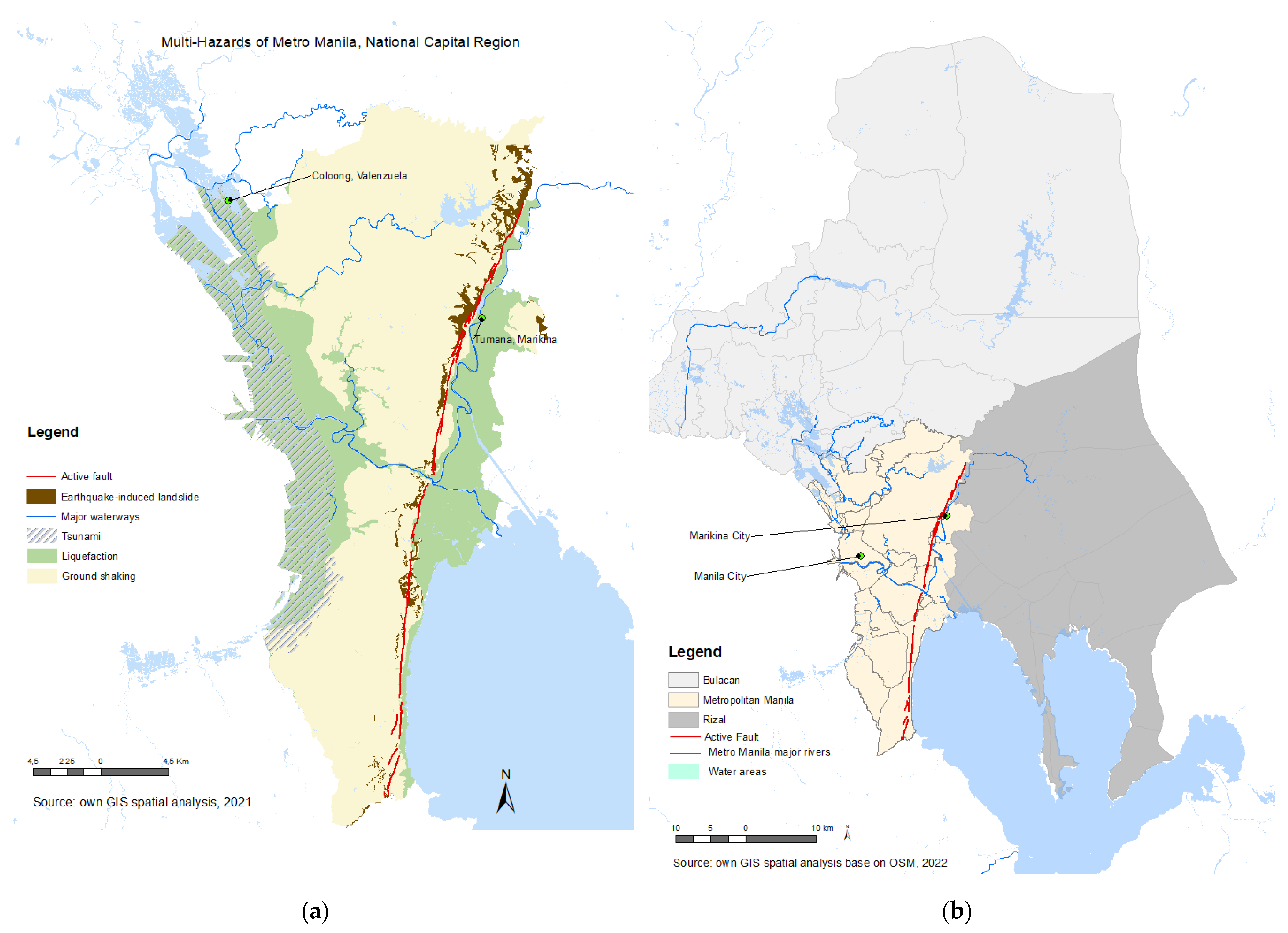
3.1. Proliferation of Informal Settlements in Metro Manila

The Philippines is located at the western rim of the typhoon belt of Pacific Ocean and along the “Ring of Fire”. It is well-known that it is one of the countries confronting the highest natural risks and extremes events. Global Facility for Disaster Reduction and Recovery (GFDRR) indicated that at least 60% of the country’s total land area is exposed to multiple hazards, and 74% of the population is susceptible to their impacts [9]. The other multi-hazards include also earthquake, ground shaking, and liquefaction, etc., (Figure 1a). United Nations Office for Disasters Risk Reduction (UNISDR) concluded that “Combing with the social vulnerability, the multi-hazard exposure causes an average annual loss of 69% of the Philippine social expenditure” [10] (p. 64). The country is encountering the challenge with its weak planning system and severe prevalence of urban informality, which is aggravated by land use conflicts and land tenure disputes. It observes that persistence of natural calamities turns out to be social issues over time intertwined with climate change. Lack of resilience, aggravated by overlay of hazards, vulnerability, poverty, and rapid urbanization make the Philippines distinctly information-rich regarding disaster resilience research.
The National Capital Region (NCR) or Great Manila Metropolitan Area, hereafter referred to as Metro Manila, consists of 17 cities. Metro Manila has been primarily developed along its north-south direction. It boarders province of Bulacan to the north and Rizal to the east (Figure 1b). Both the provinces of Bulacan and Rizal accommodate the recently developed resettlement sites, where those informal settler families (ISFs) in Metro Manila shall find a new home. These new resettlements sites result also in new urban growth, such as in the eastern province of Rizal at the upper stream of Marikina River. With ca. 13 million population, Metro Manila has the smallest area size of 667 km2 among the three studied metropolises, but with the highest density (Figure 2a). Its urban population density has been increasing, from 11,900 to ca. 13,000 per km2 between 2000 and 2010 [11]. Philippine Statistics Authority 2015 revealed that Manila city had the highest population density of 42,857 per km2 among other cities of Metro Manila [12]. As of 2009, approximately 80% of the total land area of Metro Manila had already been built-up. Intense urban development with the increase of built-up areas mainly took place during 1990s, correlated with its higher population growth. Estoque and Murayama indicated that spatial pattern of urban land changes of Metro Manila was dominated by infilling and edge-expansion pattern from the 1990s to 2000s [13]. As Philippine Statistics Authority recently released that the annual population growth rate of Metro Manila was just 0.97% (2015–2020), if compared with the rate of 1.58% (2010–2015) and 1.78% (2000–2010) [14]. Correspondingly, the increase rate of built-up areas also decreased at an average rate of 2% after the 2000s, if compared with that of 3.9% in the 1990s [15].
Additionally, very limited land resources is one of the critical hindrances regarding Metro Manila’s recent urban development. Partially, it is also due to its geo-physical limitations of water-interfaced features on both the west and east sides. The National Capital Region itself showed a saturated urban growth status. Along with last two decades’ resettlement programs, the north and northeast neighbor provinces, e.g., Bulacan and Rizal have gained substantial urban growth and expansion. Noticeably, these neighbor provinces’ urban development brought about significant climatic impacts on Metro Manila (Section 5.2). For instance, economic activities of logging and mining at the upper reaches of Marikina River in Rizal Province adversely affect settlements at the lower part of the Marikina River in Metro Manila. Consequently, besides floods per se, residents in Marikina City had to confront aftermaths of destructive landslides and mudslides after Typhoon Vamco/Ulysses in November 2020.
Informal settlements of Metro Manila have the longest development history of the studied three Metropolises. It originated in the 1950s after the World War II. Tondo Foreshore Land along the west coast of Metro Manila had developed as the largest squatter colony in Southeast Asia during the 1970s. From a population of 2.5 million in the 1960s to the current of ca. 13.5 million [14], Metro Mania has been experiencing fast urbanization, being accompanied by large amount of rural immigrants who moved to the metropolitan area. The World Bank reported in 2017 that “Urban population growth in Metro Manila continues at a very high rate in terms of both internal growth and in-migration. The combination of high population density and rapid urbanization resulted in environmental degradation and poor quality of life” [11] (p. 59). The population growth has far outpaced the urban services and housing provision in Metro Manila. As Naessern three decades ago concluded that visible signs of stagnation were the increase of informal-sector activities and of illegal housing constructions [16] (p. 201). The historical background of informal settlements and ISFs’ ceaseless confrontations with housing crisis and social inequality, the pervasiveness of the informality and ISFs’ livelihood struggles, tensions between the state and private sectors, and the national policy agenda evolution under different presidency regimes have been extensively discussed by Shatkin [17,18] and Choi [19].
Metro Manila Census of Population and Housing (CPH) measures informal settlers as households occupying rent-free lot without the consent of owners. This CPH measurement shares similarities of the household-based definition of informal settlements of UNHABITAT back to 2003, by emphasizing illegal existence of informal settlements [20]. Therefore, environmental, spatial, and vulnerability have not been focused in this regard. The recent understanding on informality and their dwellers are more into reality and brings informal settlements and communities into different dynamics especially observed in the paper of UNHABITAT III [21]. We do not have the latest official statistics to measure magnitude of informal settlements in disaster-prone areas. The National Economic and Development Authority (NEDA) reported in the Philippine Development Plan 2011–2016 that 51% of the ISFs or ca. 765,000 out of 1.5 million were living in danger areas in the Philippines. Metro Manila had 39% of the national share of ISFs, which was ca. 585,000 families [22]. Besides the treat of eviction and demolition, these ISFs living in natural disaster-prone areas must also cope with frequent flood and typhoon [23] (p. 696). The Philippine Mid-Term Development Plan 2017–2022 alarmed that the ISFs’ population in Metro Manila has been still increasing, particularly those dwelling in disaster prone areas; and their locations are difficult to track. The plan called for a strong force in formulating an operational definition and statistical framework to define informal settlers [24]. This very need of redefining and understanding informal settlements was also highlighted in the final report of Developing a National Upgrading Strategy for the Philippines, particularly those families who are dwelling in disaster-prone areas and areas designated for government infrastructure projects, etc. Importantly, this final report pointed out that the need for climate change resilience prompts priority action for informal settlements in the danger zones [25].
We can conclude that Metro Manila is continuously undergoing the proliferation of informal settlements, especially in disaster-prone urban areas. However, how to forestall the proliferation is not yet clear. Many informal settlements have strategic in-city locations with long community development histories. Their existence is persistent and pervasive rather than transitional. As the report of Developing a National Upgrading Strategy pinpointed “The pervasiveness of informal settlements (of Metro Manila) can be traced to low income, unrealistic and inadequate urban planning, lack of serviced land, a dearth in affordable socialized housing and a dysfunction legal system” [25] (p. 1).

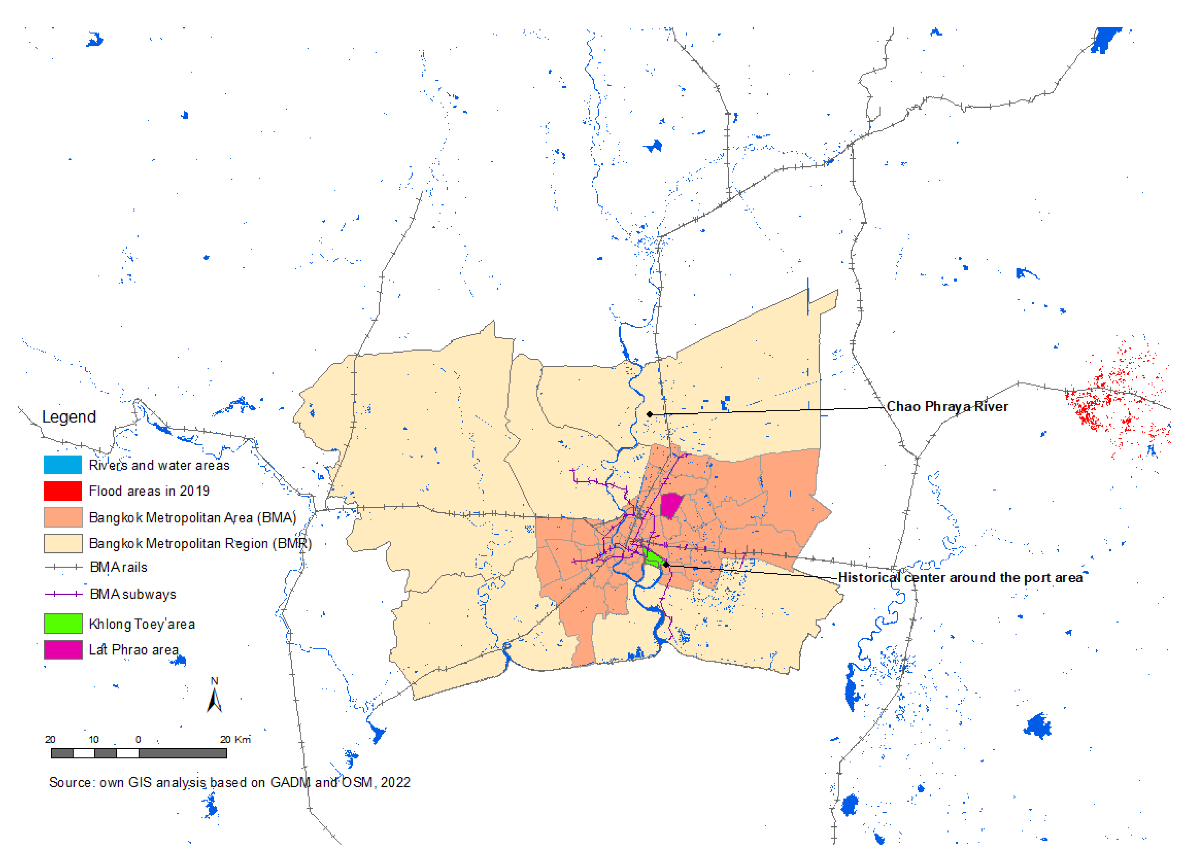
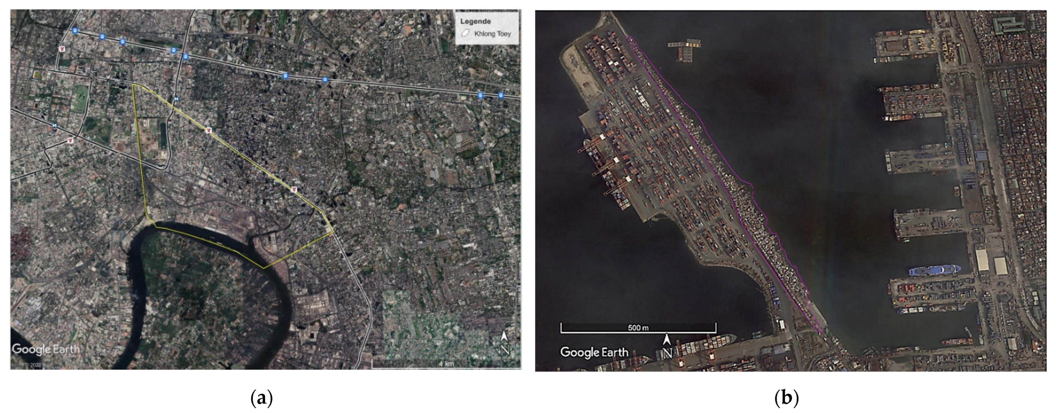
3.2. Stability of Informal Settlements in Bangkok Metropolitan Region

Bangkok Metropolitan Region (BMR) is a low-lying region in the lower part of the Chao Phraya River Basin (Figure 3). With a total area of 7762 km2, BMR consists of six provinces with 21 inner districts and 29 outer districts. Together with Metro Manila, the World Bank identified Bangkok Metropolitan Area (BMA) among the top eleven Asian megacities that are most vulnerable to climate change [26]. With a total area of 1569 km2, BMA’s average ground elevation is one to two meter above the mean sea level. Besides the sea level rise threat (ca. 1.3 cm per year), the World Bank indicated that BMA has been suffering from land subsidence at the speed of ca. 7 mm annually [27]. During authors’ workshop in 2021, Thai experts reported that land subsidence rate can be now more than 15 mm per year. Extreme ground water pumping is considered as one of the major reasons causing land subsidence, for instance, as a means to combat draught. As the World Bank further predicts “The economic damage of flooding will rise four-fold in 2050. However, 70% of the cost in 2050 would be attributed to land subsidence alone” [27] (p. 14).
According to Estoque and Murayama, BMR’s urban development mainly started in the 2000s, corresponding with its higher population growth. By contrast, this took place in Metro Manila during the 1990s [13]. They argued that there is still abundant open space available in BMR for urban development, which means that new built-up areas need not necessarily be all edge-expansions nor infilling in BMA (hereafter, interchangeably referred as Bangkok). Therefore, unlike Metro Manila with a comparatively small land area, BMR is still capable of accommodating urban development. During the 2000s, buildup land of BMR has been expanding at a relatively much higher rate with 4507 ha per year, in comparison with 906 ha per year in Metro Manila [13] (p. 221). It implied that population growth from 2002 to 2015 was increasing at an average annual rate of 3.2% in BMA, if compared with Metro Manila at 2.8% during the similar time span [15,28]. Collating the urban expansion in 1998 with that in 2002, both revealed a similar geographical trend. Namely, the expansion has been mainly along the Chao Phraya River in a north-south direction. However, as of 2015, the expansion appeared in all directions, the population distributions as well [28] (Figure 2b). From the year of 2003 onwards, Bangkok population has been decreasing in inner city at a rate of 240 persons per km2 annually, being accompanied by its continuous urban sprawl [29]. According to Thai 2016 population statistics by districts, population of Lat Phrao district (Figure 3) decreased, though not sharp, from 122,520 to 121,740 from 2011 to 2016 [30]. In a nutshell, such population decrease in inner city has been on par with Bangkok’s unceasing urban sprawl.
Authors’ cross-country workshop series in February 2020 affirmed the pressing challenge raised by BMA’s urban sprawl. The recent urban expansion took place in the north part of BMR, being strengthened by the presence of the Don Muang international airport in the north and of the port of Khlong Toey in the southeast [31] (Figure 3). The country’s north mountainous region accommodates four north-south flowing rivers (Ping, Wang, Yom and Nan). BMR bears the strong impacts out of the northern regions’ flood conditions. As a consequence of urban sprawl, workshop experts indicated that Thai cities are expanding and growing to hazard areas.
Since the late 1960s, Thai government and NGOs have conducted surveys in Bangkok to measure the magnitude of informal settlements and their population. Currently, an estimated 25% of the urban population of Thailand lives in the slums or informal settlements [32]. Moreover, according to Bangkok communities’ statistical report in 2018, 30% communities in Bangkok were defined as informal settlements [33]. Informal settlements in BMR has become an issue in tension since 1980s. Emerging reasons of informal settlements in BMR are various. Likewise, as in Metro Manila, settlement proximity to jobs is one of the vital factors in Bangkok. Contrasting to those in Metro Manila, Bangkok informal settlements are smaller scale and not always located in the public transport catchment. They mainly occupy public in-city lands e.g., along Khlongs or canals, areas of State Railway of Thailand, central old quarters close to service sectors. According to the 2019 report of Community Organization Development Institute (CODI), “There are 1161 canals in Bangkok, and 23,500 households live in informal settlements on the narrow strips of public land along those canals” [34] (p. 8). Similar to Metro Manila, Bangkok informal settlements also originated in the vicinity of the port area, due to job access. Khlong Toey District contains several large and small informal communities. It is where the residents can find employment in the Port area of Bangkok (Figure 3 and Figure 4a). In a similar manner, we have to mention Isla Puting Bato, in vicinity of container terminal of Manila port area, contains five informal communities. Accommodating more than 2800 families, Isla Putting Bato community is located on the water break along the shoreline (Figure 4b). In both cases, the respective referred port authority claims the land ownership.
How the metropolises accommodate their informal communities is observed quite culturally bound. Thai society views housing as a responsibility of the family, not the state (see discussions in Section 4.2). Prior to the 1970s, the country has not had any explicit national housing policy committed to adequate housing for all [35]. This is a considerable difference if noticing that the urban poor in the Philippines had started in the 1950s to pursue their basic housing rights and urban services as above-mentioned in Section 3.1. In this regard, Naessern also concluded that the Philippines is the only Southeast country that the urban poor produced discernible impacts on the housing and urban policies [16]. Surveys in Kamalipour’s research showed that informal settlements in Bangkok are relatively small with on average around 1000 inhabitants or 200 to 250 households per settlement [36]. Based on Bangkok Metropolitan Administration data on communities in Bangkok used by Endo [37], it can be calculated that the increase of informal settlements in inner districts from 1985 to 2006 was ca. 24%, if compared the increase rate of 87% in the urban fringe areas. There were registered informal settlements in Bangkok covering years from 1985 to 2006, showing a minimum fluctuating population size of ca. one million [37]. Burapatana und Ross argued as well that BMA suffers from ‘donut-effect’, which refers to population decrease in Bangkok center and strong suburbanization processes [38]. This echoes also the urban expansion rate and population decrease in inner city as the above analyzed. Informal settlements in Bangkok inner districts has stepped into a stable existence stance. Or in other words, the informal communities in inner districts and the population size of these communities stay stable.

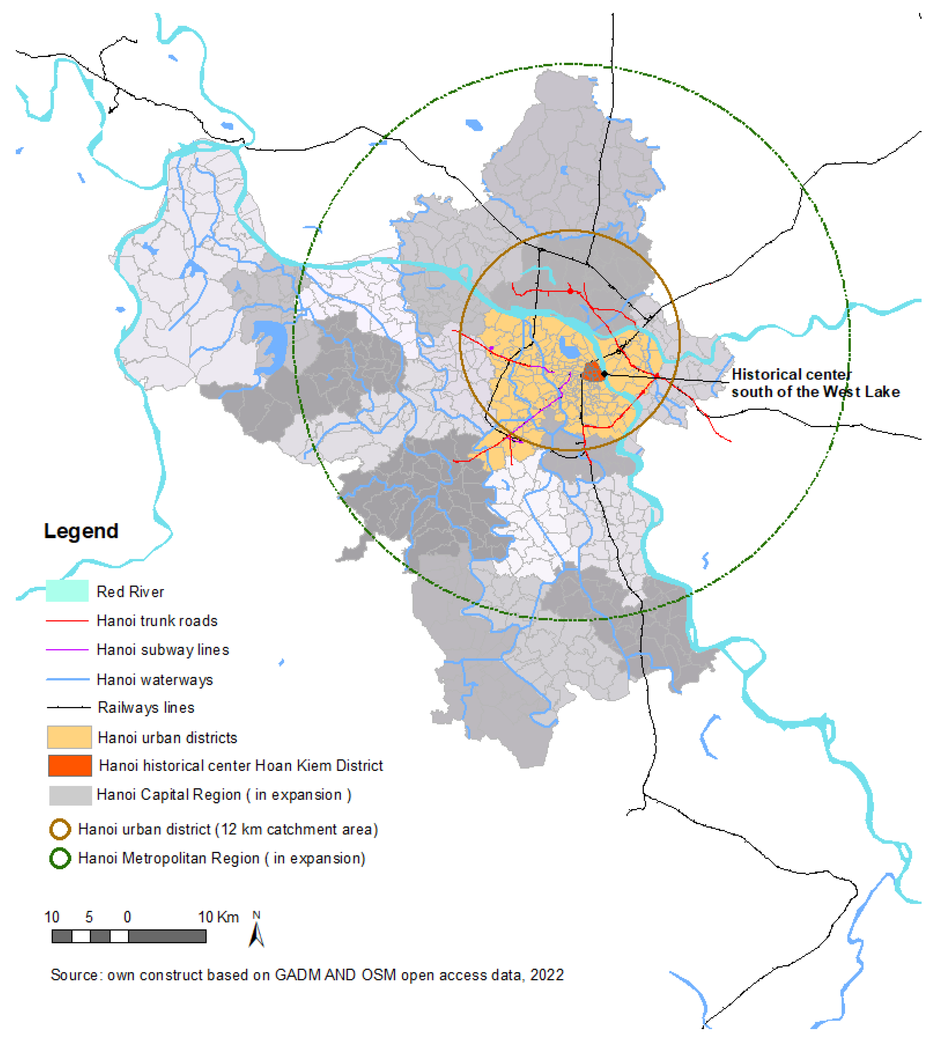
3.3. Emergence of Informal Settlements and Comprehension of Informality in Hanoi Capital Region

With a coastline of 3200 km, an estimated 70% of the population in Vietnam is living in coastal areas and low-lying deltas. The country is confronting floods and typhoons as the dominant hazards. 59% of the country’s total land area and 71% of its population are vulnerable to cyclones and floods. The World Bank and Asian Development Bank reported recently in 2021 that Vietnam has extremely high exposure to flooding (ranked joint 1st with Bangladesh), including riverine, flash and coastal flooding [39]. Further, the country is also susceptible to droughts, landslides, and seawater intrusion. This Report further indicates that “Impacts are heavily concentrated in Vietnam’s two mega-river deltas, of the Red River and Mekong River, and urban areas in their vicinity including the nation’s two largest conurbations, Hanoi and Ho Chi Minh City” [39] (p. 17).
The reality is Hanoi has been experiencing an enormous scale and speed of expanding since 1970s, especially to the west and southwest (Figure 5). From 1945 to 1954, Hanoi consisted of four urban districts with a population size of ca. 37,000, and four suburban districts with a population size of 16,000 [40]. The first significant urban expansion of Hanoi administrative boundary took place in the 1960s with both growth of urban population and economy. The administrative boundary of Hanoi reached a total size of 461 km2, compared with the previously reported 152 km2. This can be considered the first significant expansion of Hanoi in terms of administrative boundary [41]. Hanoi’s population then increased to 2.5 million when its boundary merged with five more districts in 1978. Owing to Doi Moi (Economic Reform) in 1986, its fast economic growth resulted in a huge migration wave into the urban area of Hanoi. Duan and Shibayama summarized that “Urbanization of Hanoi largely occurred from 1993 to 2000, and continues today at a low rate, primarily on the south side of the Red River” [41] (p. 11). The current Hanoi Capital Region consists of 12 urban districts and 18 rural districts. The urban districts are mainly concentrated on the south side of the West Lake, with a ca. 12 km catchment area (Figure 5). Hanoi urbanization process follows its main traffic axes. Population density in 2016 in Hanoi urban district Da Dong was the highest, with ca. 40,000 inhabitants/km2. Ba Dinh reached 25,000 inhabitants/km2 or above [42]. Such high dense areas are also where the in-city informal settlements are located, such as Xom Lieu community in Phuc Xa Ward (Figure 6a).
Quite different from Metro Manila and Bangkok, Hanoi has few informal settlements in its urban center and its densification concentrates mainly in the periphery areas. As Figure 2c and Figure 5 show, Hanoi’s urban expansion is observed along the transit network beyond urban areas on the outskirts. This leads to unplanned development patterns at the edge of the city. Suburban villages, which lack basic public services with substandard housing quality, are part of the urban expansion outcomes. Often, these villages are also located in low-lying flood-prone areas.
Noteworthy to mention is the understanding of informal settlements unfolds a very different mindset in Vietnam context. Authors’ very first cross-country stakeholder workshop in 2020 brought about the aspect of how to define and position informal settlements in different city-regions. Vietnamese participants indicated that the phenomenon of “informality” as described in Metro Manila and Bangkok cannot represent in the Hanoi urban context. In a similar note, Minnery et al. also summarized that “There is no equivalent of the term ‘slum’ in the official Vietnamese policy documents” [43] (p. 166). During this workshop in 2020, Vietnam participants associated informal settlements with the village system at the periphery and suburb of Hanoi, which was partially an outcome from the unplanned urban expansion as discussed above. The fact is these villages are now forced to be urbanized and transferred from township to urban ward or districts. These villages need solid waste disposal and functional infrastructure in line with Hanoi’s further urban growth. Despite being urbanized, these villages are still considered as traditional residential land in planning, and there is no macro project to develop those areas [44]. There is observed a planning dilemma regarding how to juxtapose these villages between urban and rural. Vietnamese experts also confirmed that because of the economic growth since 1990s, encroachment process of such villages (informal settlements) in Hanoi’s peripheries has shown the city’s failure of regulating the formal land and housing markets, as well as the city government’s ineffectiveness in delivering the low cost housing programs.
During authors’ workshop in 2021 with Vietnamese experts, the in-city informal settlements caught the attention. These in-city informal communities are along the Red River in the inner Hanoi urban areas. Currently, with ca. 70 families, Xom Lieu community in Phuc Xa Ward of Ba Dinh District is the most representative and known in-city informal community (Figure 6a). Residents here are working as street vendors, porters, or bottle pickers. These dwellers have no household registration. Despite its relative smaller scale, the local government has no control over the informal community living in this area.
Besides the suburb villages at Hanoi’s periphery, this workshop identified two types of urban “informality” in the Vietnam context:
Type I: Disaster-prone communities: Because of income-earning opportunities, the settlers opt to stay near transport lines, industrial zones or along river, where the sites are liable to multi-hazard such as industrial poisonous waste, flooding, or landslides. Residents experience high level of poverty and social exclusion. The communities have similar attributes as those in Metro Manila and Bangkok such as lack of basic services, access to drains and sanitation, overcrowdness, threat of being evicted and demolition, etc.
Type II: Dilapidated housing stock with illegal extending: Second type of informal settlements is the multi-family apartment blocks (nhἀ tập thể), built in the socialism era of the 1960s–1980s (Figure 6b). Commonly, they are four- to five-story walk-up apartments named as KTT in Vietnam. These building stocks were state-owned and accommodated originally those civil servants, working staffs of state-owned factories and firms. These building blocks are in a very precarious and degraded stance, leading to unsafe living conditions, particularly the illegal extending of block structures. 140,000 Hanoi residents, or 1.5% of the total population, are dwelling in ca. 450 of such blocks (sourced from Vietnam experts during the workshop in 2021).
Authors’ workshop series concluded that the emergence of Hanoi’s informal settlements is mainly due to the rural to urban migration in the period of Hanoi urban transformation. Workshop participants agreed that management of informal settlements is highly linked with rural-urban development dynamics. They are not as prevalent and persistent as those in Metro Manila. As the World Bank clarified: “A primary motivation for maintaining the status quo of a restrictive ho khau system (household registration) is to control migration to major urban areas (…). The policy has undoubtedly helped Vietnam’s large metropolitan areas avoid urban problems (…) such as urban segregation and the prevalence of slums” [39] (p. 105). Though Hanoi has a better overview of its informal settlements if compared with Metro Mania and Bangkok; experts foresee the incoming difficulties in identifying and tracking these informal communities. Similar to Bangkok, uncontrolled urban sprawl and expansion are considered as Hanoi’s current pressing issue.

4. On-Site Upgrading Undertakings in Three Metropolitan Regions

4.1. Metro Manila—From Zonal Improvement Program Era to Community Resilience Building

The first government housing program in the Philippines began in 1938 during the Commonwealth period under President Manuel L. Quezon whose program then was to entice people to move to the new capital city (now Quezon City) [45]. This program was continued during the post-war reconstruction by succeeding presidents to provide housing to many families displaced by the war. A number of housing agencies were created to implement the new programs such as the People’s Homesite Corporation (1938), the People’s Homesite and Housing Corporation (1947), and in 1975, during the administration of President Ferdinand E. Marcos, Sr., the National Housing Authority [45].
A housing program started during the martial law years under President Marcos was the Bagong Lipunan (or New Society) Improvement of Sites and Services (BLISS) housing program [46]. The BLISS may have been the first housing model in the Philippines that advocated for a “holistic” approach where eleven basic needs of man namely food, water, shelter, clothing, energy, mobility, education, health, ecology, sports, and social recreation were supposedly incorporated in the development. The BLISS were intended to be developed as model human settlements in the poorest areas of each of the 1600 towns and cities all over the country [46]. This housing program may have been an earlier example of on-site upgrading.
Simultaneous to the implementation of the BLISS housing program was the Zonal Improvement Program or ZIP under the National Housing Authority (NHA). The ZIP was started under a loan from the World Bank [47]. The main objective of the ZIP was the provision of security of tenure to families occupying public and/or private land (authors’ interview with Ar. Monn Alexander Ong and Ar. Luis Bacamante of NHA, September 2021). As such, a huge budget was needed to purchase these lands, which were later apportioned and distributed to families “at the same cost”. Based on interviews, communities under the ZIP were considered the most blighted areas in a city or municipality. The ZIP exercised the “as is where is” approach, which called for maximum retention of housing structures. Housing structures were retained as is and were only modified if a structure had to give way to access networks under a reblocking scheme. Many blighted areas lacked basic utilities and infrastructure such as water and power supply, drainage systems, and roads and pedestrian walks. The latter were a necessity especially during emergencies such as fire that allowed people to move out of a dangerous situation quickly and allowed fire trucks to enter and extinguish a fire. Flooding was a perennial problem of many blighted areas that the ZIP intended to address. The ZIP during this time was intended only to upgrade blighted areas, especially flooding, which was often associated with sicknesses brought about by waterborne diseases. Upgrading to address disasters were unheard of during this time. A positive outcome of the ZIP was the eventual integration of a community into the rest of society. This may be observed in some ZIP areas wherein the Local Government Unit (LGU) would takeover in the upkeep of streets, provision of street lighting, collection of garbage and building of community facilities such as a basketball court and multi-purpose hall.
The enactment of Republic Act 7279 or the Urban Development and Housing Act (UDHA) in 1992 [48] was a very important milestone for the housing sector. The UDHA may be viewed as a reaction to the inhuman and very violent demolition and forced eviction by the military during the Martial Law period under President Marcos [49]. The UDHA spelled out the essential steps for all procedures that government and private agencies must follow before, during, and after resettlement as well as on-site upgrading. It was after the passage of the UDHA that the term “squatter” was replaced with “informal settler family” or ISF. The UDHA contained provisions for a Zonal Improvement Program or on-site upgrading. In it were components of what a decent settlement should contain. A significant practice enunciated under the UDHA was participatory planning whereby a community to be resettled was consulted as to their preferred resettlement site. This practice served as the foundation for future approaches such as the people’s planning process initiated by non-government organizations and civil society organizations in resettlement and on-site upgrading programs. Off-city resettlement also became the last option, i.e., before resettlement, government and private entities were told to explore on-site development, followed by near site or in-city resettlement before off-city resettlement was resorted to.
Planning on-site and resettlement programs in the face of disasters due to climate change were taken for granted until Typhoon Ondoy (international name Ketsana) in 2009 [50] when almost 80% of Metro Manila was submerged under flood waters. The catastrophic impact of floods due to climate change awakened both government and private individuals. Climate change and the threat of flooding had become a reality. Soon after, all LGUs were tasked to come up with disaster-preparedness plans to ready communities for the onslaught of disasters. During the administration of President Benigno Aquino III, a 50 billion peso budget was released to resettle ISFs living atop of waterways and within the 3-m easement on the banks of waterways in support of a flood control masterplan for Metro Manila [51]. Although the main activity focused on resettlement of roughly 104,219 families, on-site development were proposed for families living beyond the 3-m easement along the major waterways of Metro Manila. CSOs focused on improving both coping and adaptive strategies of communities. A number of such coping and adaptive strategies documented from interviews with CSOs and concerned community members are presented below.
Institutional coping and adaptive strategies focus on ISF’s struggle to acquire ownership of the land they occupy. In the Philippines, owning one’s land or obtaining tenure security remains the single most important goal of many ISFs and is very much associated with being resilient [52]. Financed by Social Housing Finance Corporation (SHFC), the Community Mortgage Program (CMP) is an on-site community development program established in 1988. CMP was intended to be an asset redistribution scheme where homeless low-income families could acquire land through affordable mortgage financing and hold it in the concept of community ownership. CMP upholds principle of minimum demolition and maximum retention. Land tenure was expected to be secured during the time of the mortgage [53]. Gaining possession of the land means that ISFs cannot be evicted from the area where they reside. There are also several studies on CMP that show ISFs begin investing in their houses by making these stronger and higher to lessen their vulnerabilities to typhoons and floods once they acquire ownership of the land [54]. A number of ways ISFs may secure ownership of land have been introduced over the years, though we have to differ land ownership from individual titles (see discussions in Section 5.1). These are: 1. Direct negotiation and purchase of land by ISF; 2. the local government purchases the land from landowners, apportions the land and sells this to ISFs [45]; 3. usufruct agreement; 4. presidential proclamations [55]; 5. residential free patent [56]; and 6) expropriation [57].
Under social adaptive strategies, community resilience building is achieved when ISFs organize themselves into a legitimate homeowners association (HOA) empowering them to deal with local government, national government agencies, donor agencies, civil society organizations, etc., to address their needs and other targets in achieving resilience. Organized HOAs engage in participatory planning ensuring collective decision-making processes and greater ownership of development/action plans of the community [58]. Networking with relatives, friends, and neighbors in the community as well as joining civic and religious organizations increase their chances of acquiring assistance to cope and survive.
Under economic coping and adaptive strategies, Informal Settler Family Homeowners Association (ISF HOA) institute, among themselves, established their own community savings program, which they use for various programs and projects beneficial to their community such as upgrading projects including house repair, sustainable livelihood programs, and during times of emergency as well. The community savings allow the ISF HOA to be more independent and pro-active [59].
Physical coping and adaptive strategies pertain to ISF building their community and houses following the adjusted building codes to ensure their safety. ISFs are taught about the secure way of constructing their houses to withstand stronger typhoons, proper drainage infrastructure, fire safety, provision of access networks to and from their community. ISF communities are also informed about the location, for example, of evacuation centers and the shortest and safest routes to these [60].
Finally, under coping and adaptive strategies on the environment, ISFs are trained about the importance of conducting environmental risk assessments prior to resettlement and actual building of homes [61]. Risk assessments include susceptibility of site to flooding, mud- or landslides, presence of fault lines, strong wind, sources of pollution which may affect their health (toxic fumes, unsafe drinking water), and the like. ISF HOA members likewise undergo regular training on disaster preparedness and how to respond to early warning systems. They are constantly updated about the location of critical infrastructure in their areas so they know where to seek help during calamities.

4.2. Bangkok Metropolitan Region—Community Driven Upgrading with the National Institutional Support

Many studies demonstrate that housing has been long time viewed as a family owned responsibility in Thai culture. In Thailand, there have not been any clearly formulated national policy or committed actions plans for housing [35,62,63,64,65]. Particularly, there is an absence of housing policy for low-income groups, who have not claimed their housing rights. As informal communities turning as an issue in Bangkok in the 1980s, the government established the Urban Community Development Office (UCDO) under the Thai National Housing Authority (NHA) in 1992. The objective was to address urban poverty. In 2000, Community Organization Development Institute (CODI) was founded and replaced UCDO as a public organization, not anymore subject to NHA. The main mission of CODI is to conduct Baan Mankong program (collective housing for the poor), with target of 300,000 urban poor households in informal settlements. As the main implementer of upgrading programs in Thailand, CODI is an independent legal entity under the Ministry of Social Development and Human Security.
Thai upgrading activities under CODI are in general auxiliary with an allocated national budget annually, via CODI’s yearly proposed budget plan to the national government, so to get grant for housing upgrading and loans for housing. Taking the three-year action plan of CODI (2020–2022) for instance, there are four covered main issues:
(1)
Location-based development promoting self-organized communities;
(2)
Toward structural and policy change through collaboration between local communities and relevant stakeholders;
(3)
Capacity building of community organization networks;and
(4)
Developing management system for community organization.
Community Organization Development Institute (CODI) enables a flexibility for informal settlement upgrading in terms of upgrading options [34]. Reblocking is often systematically adopted to adjust the settlement layout and roads distribution, so that public spaces and infrastructure facilities (new sewers, drains, etc.) can be installed. Importantly, upgrading operates with an established community collective legal entity that can take housing loans, receive other development subsidies and buy or lease land collectively. One of CODI’s main activities has been to provide loans for community development. All loans from CODI are given in bulk to community groups—never to individuals [34]. Community organizations are responsible for finding land, negotiating tenure arrangements with landowners, designing housing projects, and implementing them. In this way, residents are bound together to achieve agreed upgrading objectives. The adoption of collective land tenure rather than individual tenure ensures more effectively the upgrading beneficiaries to keep the land. This makes Baan Mangkong Program distinct, if compared with CMP in Metro Manila. As reviewed in Section 3.2, Bangkok canal-side communities such as in Lat Phrao District is associated often with informality, the canal settlements had successfully “(…) negotiated long-term leases to the public land they occupy and used the Baan Mangkong Program to finance projects to rebuild their houses and redevelop their settlements with canal-side walkways, gardens and public spaces” [34] (p. 8). Community Organization Development Institute (CODI) proposed three housing development models for the canal/Khlong communities, including: 1. New construction on current dwelling lands, leased from the Treasury Department; 2. demolition and construction of new communities on new land; and 3. leasing of buildings in the existing National Housing Project. CODI’s canal community upgrading activity reflects partially a synergy of BMA Master Plan on Infrastructure of Canal System and Khlong Community Development. Despite the consideration of environmental and infrastructure aspects, CODI’s experts uttered that their upgrading projects have not fully integrated geo-hazards with the site selection criteria. Land suitability study is not amalgamated with upgrading. In a nutshell, climate change and adaptations have not yet amounted to a significant level for upgrading projects (see Section 5).

4.3. Hanoi Capital Region—Revitalization of Socialism Legacy along with Urban Expansion

The National Urban Upgrading Program (VUUP) in 2009 was patterned after the Philippine Zonal Improvement Program (ZIP) in the 1980s (authors’ interview with former VUUP staff). VUUP is the first national strategy that institutionalizes in situ or on-site upgrading as an approach for reducing urban poverty. VUUP is also funded by the World Bank, prioritizing low income urbanized areas in Vietnam. It concentrated on four major cities with provincial capital status, namely: Ho Chi Minh City, Hai Phong City, Nam Dinh City, and Can Tho City. The main implementer is the Ministry of Construction (MOC). VUUP surveys were conducted in 2006 and 2007 by the Centre for Environmental Protection and Sustainable Development, commissioned by the MOC for the preparation of the National Urban Upgrading Strategy and Overall Investment Plan for Urban Upgrading to 2020. Authors had an opportunity to discuss with the VUUP staff who was involved in VUUP strategy development and area selection criteria. The discussions revealed that the environmental factor such as flooding was included as one of selection criteria for project priority areas. Besides targeting poverty alleviation, VUUP upholds principles of improving the environmental standards of the urban centers. One of the VUUP’s objectives is to assess the need for improved peri-urban planning and development in order to minimize the creation of new, informal and low income-areas (see urban periphery villages in Section 3.3). “Yet, despite this successful focus on in situ upgrading, a considerable proportion of the target communities has been and will be affected by resettlement within the framework of urban upgrading” [66] (p. 2). Discussions in Section 5.2 also partially evidenced the approach of resettlement still has priority over on-site upgrading.
Section 3.3 unfolds Hanoi’s unrivalled scales and speed of urban expansion during the 1980s and the 1990s. It has been accompanied by the unprecedented migration from the rural areas to urban centers. On par with the immigration into Hanoi, hazard-prone areas are becoming an integral part of Hanoi’s migration dynamic. It creates the conditions that have made certain areas of the city affordable, thus enabling settlement by low-income people [67]. This is also embodied by urban informal settlement Type I (Section 3.3) along the Red River in Hanoi center.
Very different from the Philippines and Thailand, land in Vietnam is collectively owned by communities and administered by the government on their behalf. Therefore, under such a system, property owners cannot have full and legal ownership of land and their rights are limited to land use rights permitted within the law. The referred law is Land Law 2013. Land users typically receive a land use right certificate (LURC), which shows the land users’ rights on the property. In Hanoi, all lands are registered. Officially all informal settlements are managed by the government. Since 2015, “The Housing Law has reoriented housing policy toward urban areas, particularly self-built housing and affordable rentals” [68] (p. 92). This law promotes self-built housing and encouraging rental housing. In addition, this law emphasizes renovating old public housing stocks or KTT (Type II informal settlement in Section 3.3). Majority of these public housing stocks were commercialized after 1986 Doi Moi economic reform in Vietnam. The state sold these buildings at a low price to tenants, who have been long time living in the apartments. The arising acute issue is these socialism-era public housing stocks are now in a severely dilapidated situation [43,69]. Illegal modifications with extensions emerged as an unguided self-help activity among the owners. For those structurally safe building blocks, there existed potentials to be upgraded on site. During authors’ workshop in 2021, Vietnamese experts indicated that there exist interests in upgrading these blocks and the adjacent block areas. Moreover, they plan to redevelop these blocks as commercial areas, since their locations are becoming urban centers owing to the urban expansion. However, upgrading demands economic viability. Private investors and state agencies have not found a balance of profits and benefits with conjuncture of KTT’s upgrading. Though the building blocks are privatized, the lands and the commonly shared facilities and infrastructure (e.g., corridors, sewerage, etc.) are still under the state management. At the current phase of authors’ research, we have not yet examined whether KTT has the highest potential to be upgraded, while considering both environmental and socio-economic aspect. Nonetheless, it provides us a quite different landscape, which resilience upgrading can address.

5. Discussions and Contemplations

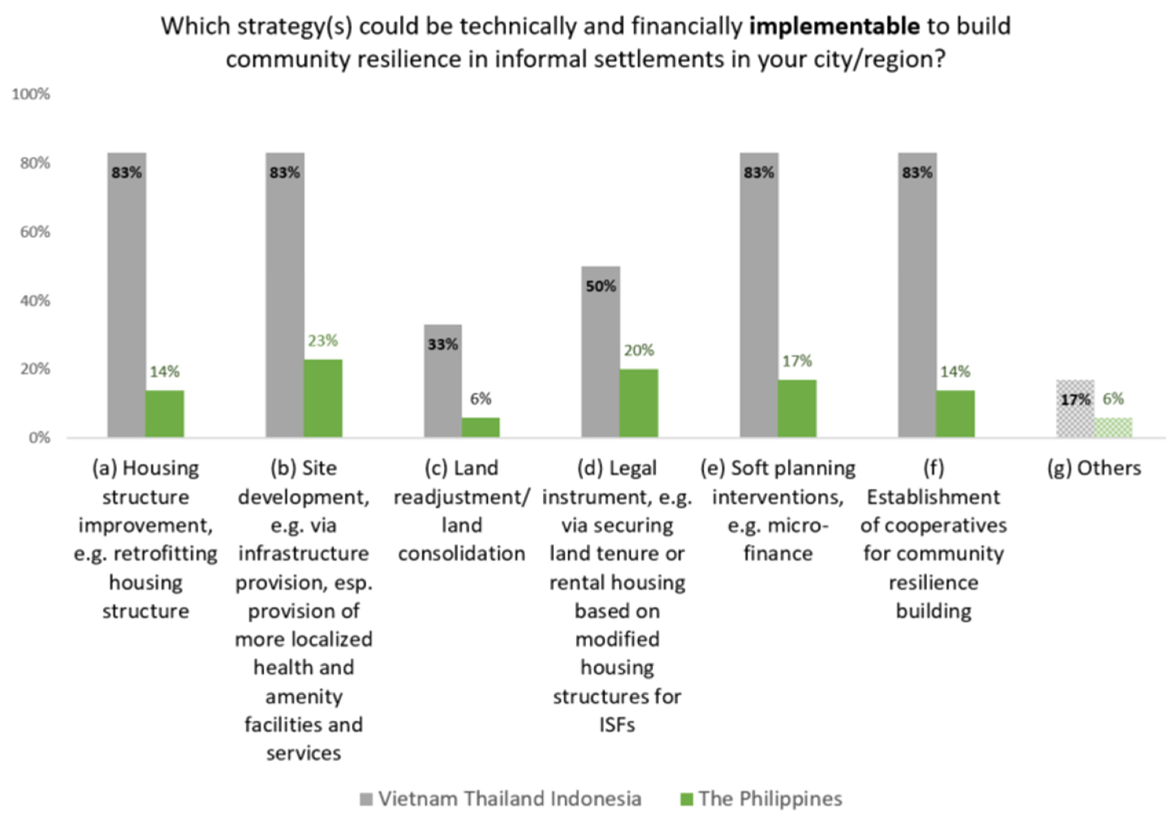
5.1. Strategies of Informal Settlement Upgrading and Its Role in Building Resilience

Since the COVID-19 pandemic, there has been observed a similar attitude among the three countries as regards government financial allocation shift in supporting upgrading (Figure 7). All three countries’ participants (additionally Indonesia) concluded that there would be fewer financial subsidies from the government. Consequently, role of the local government is particularly decisive in forging on-site upgrading in terms of upgrading priorities and funding allocations in the pandemic durations.
Second, all regions show a positive policy trend on developing and implementing standards to incorporate disaster risk reduction management (DRRM) and climate change adaptations (CCA) to address low-income groups’ housing issue. Nevertheless, cross-country survey results display a low priority of mainstreaming risk-sensitive planning in housing policy (Figure 8). There is detected a gap of using housing as a mechanism in resilience building.
Third, as for DRRM vertical implementation at the settlement planning level, certain gaps were identified. About 40% of cross-country workshop participants indicated that there is no clear signs regarding the integration of evacuation plans with settlement planning in their cities (Figure 9). Earlier in 2020, authors recapitulated that on-site upgrading in the Philippines is not a priority as a resilience strategy for disaster mitigation and risk management. Reasons are multifold and analyzed at both the national and local level [5]. For the time being, the Philippines national government promotes on-site upgrading via developing lands for ISFs, instead of allocating lands to the poor for individual titling achievement. Authors’ interview with Director Jeanette Cruz, Department of Human Settlements and Urban Development (DHSUD) revealed that there is a shift from merely providing individual land titles for land tenure security to collectively developing disaster resilient settlements.
How to collocate on-site upgrading and resilience building exhibits a different landscape among Vietnam and Thailand (additionally Indonesia), if comparing with the Philippines. When being asked upon the performance of on-site upgrading regarding its role in resilience building, 83% of respondents indicated they need active NGOs and CSOs in assisting upgrading implementation to achieve resilience building. By contrast to the Philippines, 67% of respondents uttered that on-site upgrading as a resilience strategy is not well-known (Figure 10).
For a closer check, upgrading programs in Vietnam have to follow the master plan, which has not tackled adverse impacts of climate change and recent extreme disaster events in the country yet. VUUP in Vietnam in the 2000s and ZIP in the Philippines in the 1980s have not introduced concept of resilience in their proposed upgrading activities. However, environmental and disaster factors were integrated in the preparation of the final report titled as Vietnam National Urban Upgrading Strategy and Overall Investment Plan for Urban Upgrading to Year 2020 (NUUP). Vietnamese experts commented that forced evictions were seldom in dealing with informal settlements. They acknowledged that incorporation of livelihoods with urban upgrading projects failed. The existing climate policies rarely address inequality and livelihoods or the needs and perspectives of the poor. Further, the role of upgrading for resilience building seems not being levelled up as expected. 83% of Thai and Vietnamese experts uttered that there is no defined assessment framework. Upgrading attained only single-aspect achievements, when being asked “Concerning the assessment of informal settlement resilience upgrading needs, what can you say about the achievements of assessment in terms of physical, ecological and socio-economic?”. Explicitly, Thai experts from CODI pointed out that their current on-site upgrading activities have not been substantially integrated with resilience building, despite its success in securing housing and improving general living and environmental conditions (workshop series results).

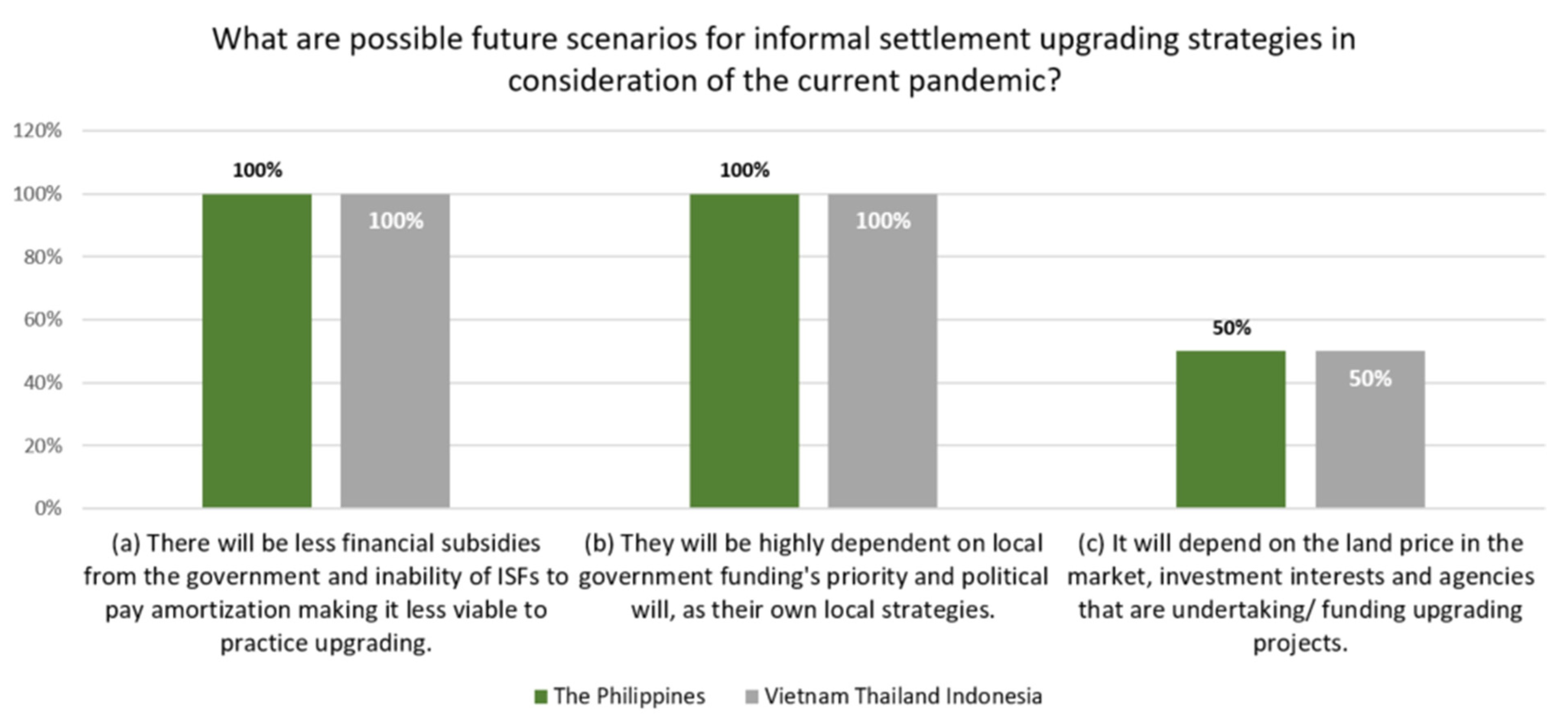
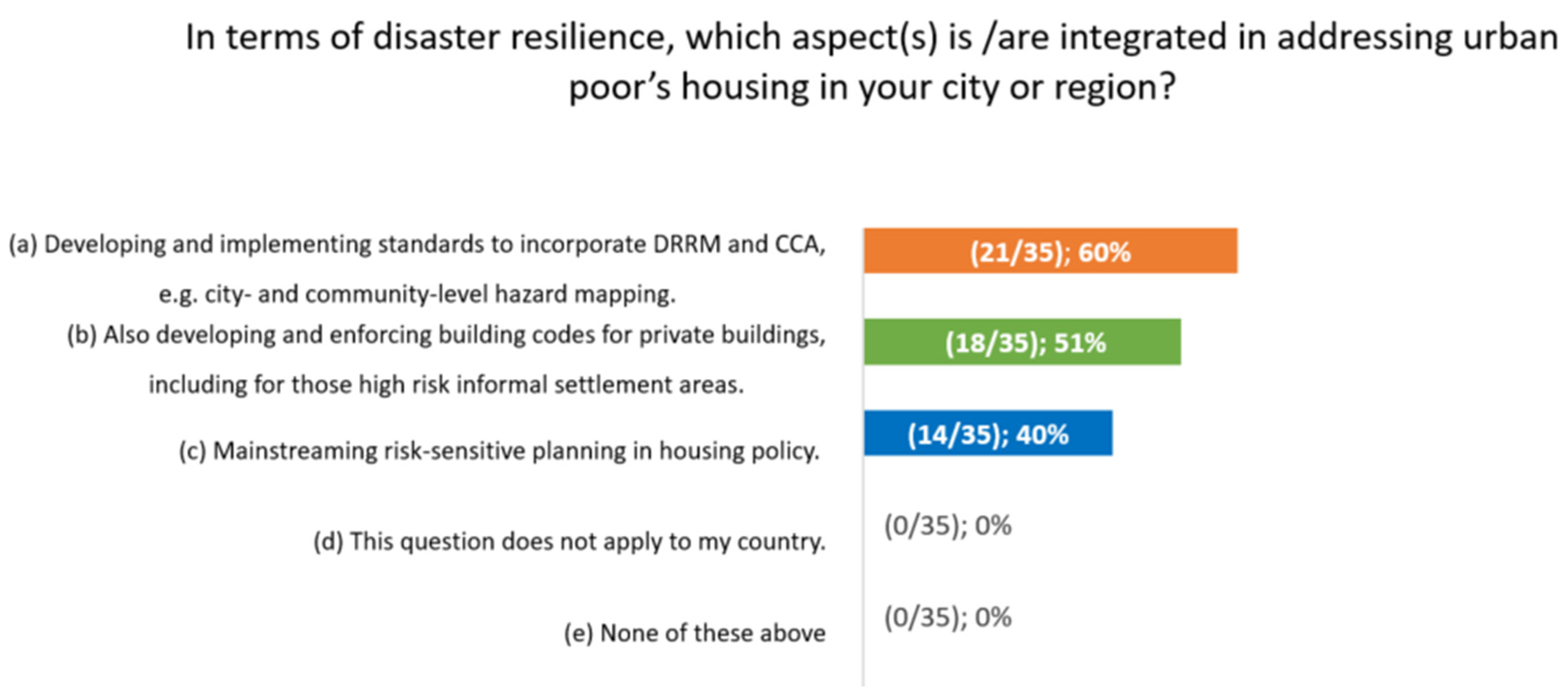
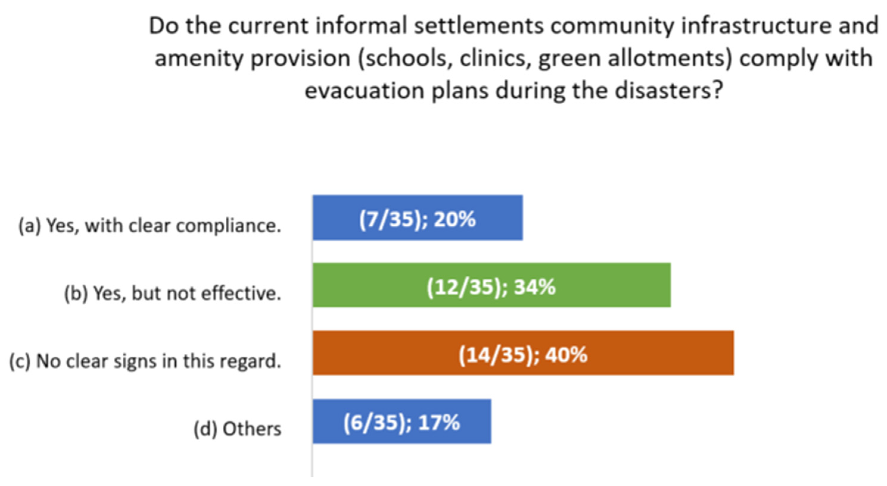
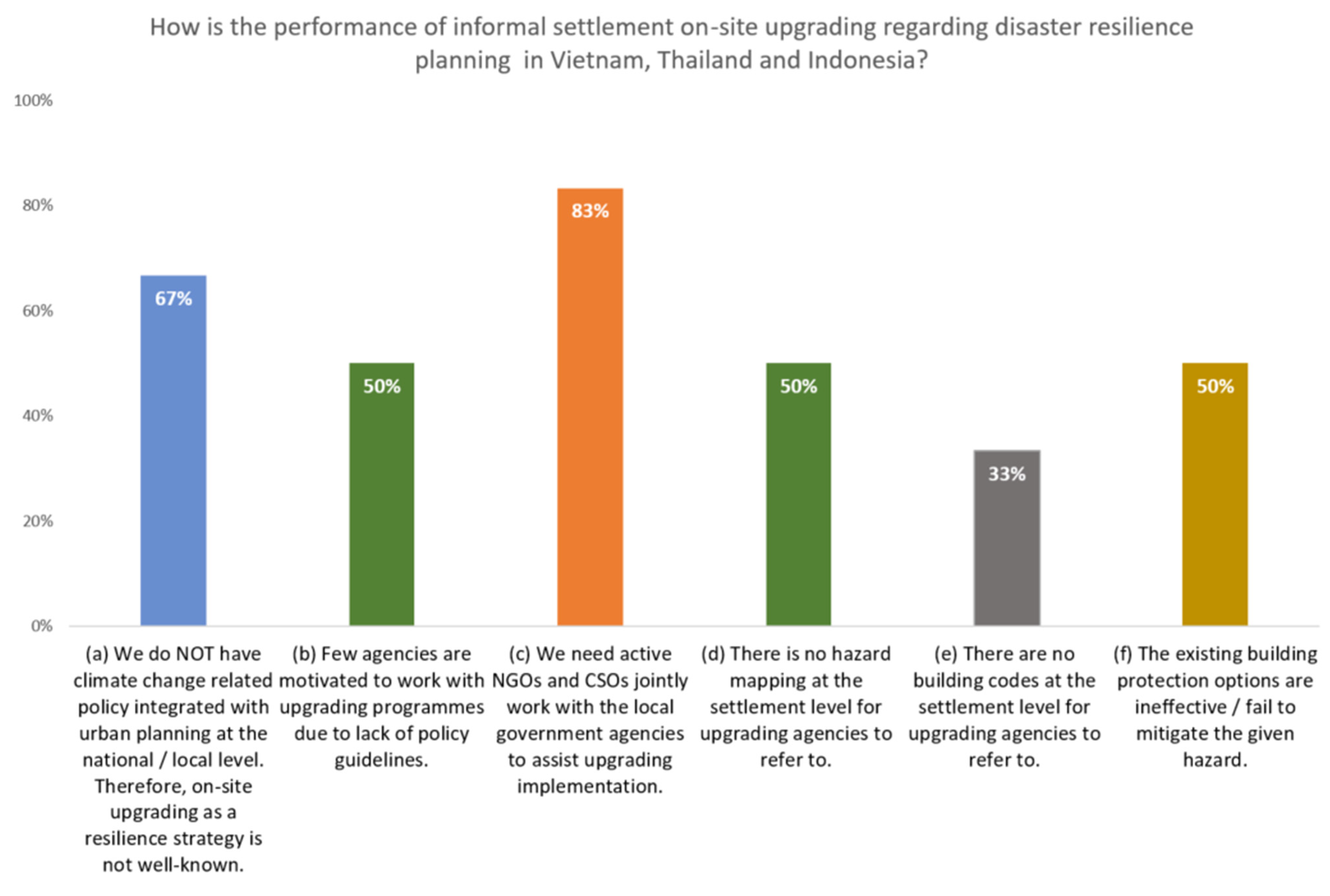
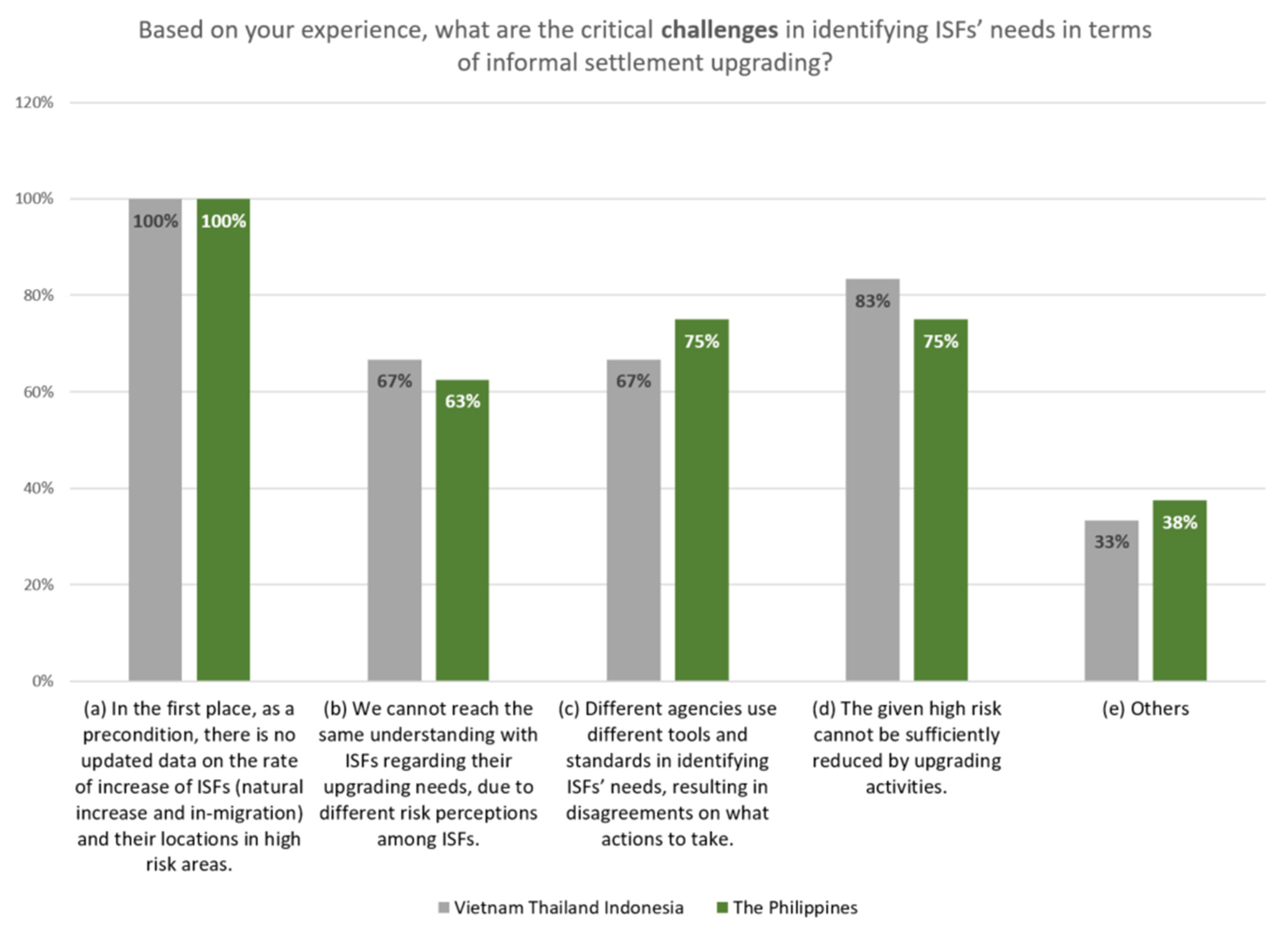
5.2. Status, Challenges, and Demands of Resilience Upgrading for Disaster Risk Mitigations and Climate Change Adaptation

5.2.1. Metro Manila

The Philippine Development Plan 2017–2022 strengthens the fact of the continuously increasing ISFs in hazard-prone areas. It also implies haphazard and precarious housing constructions in these high-risk urban areas. This will accordingly trigger further risks and result in the increased vulnerability of the ISFs. For decades long, the challenge facing the government has been the need for relocating and resettling households from danger areas. After two decades’ implementation of resettlement, there has been observed a revival of on-site upgrading in Metro Manila. However, workshop participants indicated risk mitigations collocating with on-site upgrading have not packed together. In terms of identifying ISFs’ needs on upgrading, all three metropolises (additionally Indonesia) have conditional difficulties in obtaining updated data (Figure 11).
Noteworthy to mention, the status report of UNDRR in 2019 concluded that the Philippines is one of the leading countries in disaster risk reduction management with the country’s progress in integrating DRR into the national laws and ordinances given the country’s awareness of achieving Sustainable Development Goals (SDGs), such as setting up disaster management office at the local level [70]. With this note, the Philippine National Disaster Risk Reduction and Management Plan (NDRRMP) 2011–2028 adjusted that local residents negotiating with risks becomes critically important. The Plan dictates LGUs must allocate 5% of total revenue to DRR, 30% on response, 70% for preparedness [71]. Metro Manila performs well regarding involving its local communities in DRRM. Specifically, NDRRM Plan mandated community-based hazard mapping at the lowest administrative level, Barangay (ward). As fieldwork learnt, communities updated regularly their hazard maps, which are publicly accessible in their community centers. Authors’ studied communities in Metro Manila conduct regularly workshops and drills concerning the preparation and prevention of natural disaster events. However, the Philippines has currently no building codes for high-risk informal settlement areas. What is being applied is actually designated for the socialized housing (BP 220 design standards/national law). BP 220 is for new sites rather than for upgrading sites, which require compelling flexible and affordable housing solutions for ISFs. “The standards embodied in BP 220 are more applicable to private sector-initiated housing projects that target the middle- to low-middle income formal market rather than the specific circumstances of ISFs [72].

5.2.2. Bangkok Metropolitan Region

During the 2020 workshop, Thai participants remarked the need of mainstreaming climate change adaptation into the urban policy and planning. They were keen on learning how to optimize their planning institutional arrangement in a more holistic manner to adapt the climate change. Thai participants pointed out that they have few bottom-up strategies in this regard. Many Thai cities are experiencing drought now (particularly in the country’s south, e.g., Phuket). As introduced in Section 3.2, with the currently steady sea level rise and land subsidence rate, the metropolis is facing severe impacts of climate change. It is expected to have longer drought period and hotter seasons in the future due to climate change. Thailand Department of Disaster Prevention and Mitigation announced that drought, together with flood and typhoon were acknowledged at a high risk level in its 2012 report [73]. Nevertheless, Thai experts said drought as a slow on-set disaster type is still very new for them to handle. They reflected that Thai cities are not yet prepared for new climatic hazards. The World Bank indicated a large number of new buildings will be subjected to land subsidence in the flood-prone areas, particularly in the west districts of BMA [27].
BMA currently still focuses on flood prevention and mitigation. Adaptation is not prioritized in the policy-making. Authors’ workshop in July 2021 addressed the metropolis need of integrating CCA with its Comprehensive Land Use Plan. Importantly, participants also reported that BMA’s Comprehensive Land Use Plans (CLUP) are not strongly integrated with its neighboring provinces. Such disintegration leads to an incoherence with the regional risk mitigation. They need to find the existing gaps to adapt CCA. For the time being, one of the focal revision outcomes on the current Bangkok Comprehensive Plan (B.E. 2556) significantly deals with provisions and measures. The revision requires consideration of climate resilience issue. As the 4th revision of the Plan originated in 1992, it was expected to be enforced in 2024 [74]. There is an amendment of increasing open space for water retention and flood prevention. The expected new Comprehensive Plan is also closely related with Bangkok Master Plan on Climate Change 2013–2023, which commissioned Japan International Cooperation Agency (JICA) to draft a technical cooperation. The Draft shall give an emphasis on the current and future mitigation of natural disasters and the adaptation of climate change. For instance, hazard mapping was specifically referred at the adaptation planning level in the Bangkok Master Plan on Climate Change [74].
Scaling down at the urban informal settlement upgrading level, the primary upgrading challenge for disaster risk mitigations is the lack of city-level hazard maps in Thailand. There is no mandated hazard mapping at the community level in Bangkok. Second, despite the existing policy of promoting CCA, there are no implementations and demonstrated lessons to learn. The awareness and legal actions in DRM at the community level falls behind of Metro Manila. Particularly, when on-site upgrading and DRM have to be mutually addressed, there is no clear framework aligned with upgrading sites selection criteria, land availability, and suitability for upgrading. In another word, essential topics of where the safe locations can be for on-site upgrading and where the development can be invested are under-researched. Baan Mankong Program has been successful since its implementation. Nevertheless, CODI experts raised explicit concerns regarding risk mitigation and adaption in conjunction with on-site upgrading:
(1)
Above all, the role of Thai cities in climate change adaption is unclear.
(2)
There lacks a clear definition of risk areas aligned with upgrading site selection.
(3)
There is no agreed budget scope for adjusting settlement and building design standards to cope with natural disasters.
(4)
In Thailand, building codes are not discussed in the context of flood management or climate change.
(5)
There need flood retaining areas to accommodate seasonal flooding in BMA, e.g., reserving agricultural areas in Bangkok for this purpose. Such need shall not be considered in the framework of on-site upgrading.
In Bangkok, low-income communities without land tenure had to pay for cost of flood preparation more than their monthly income. Authors’ discussions with Thai experts also revealed different income groups’ acceptability of risks. Though, the low income communities have in general low coping capacity, they refused to leave their properties unattended during flooding with strong fear of losing their assets. The high income groups are likely to place their own safety in the first place over loss of assets. Similarly, informal and low income communities need longer time to get back to the normality after the flooding events.

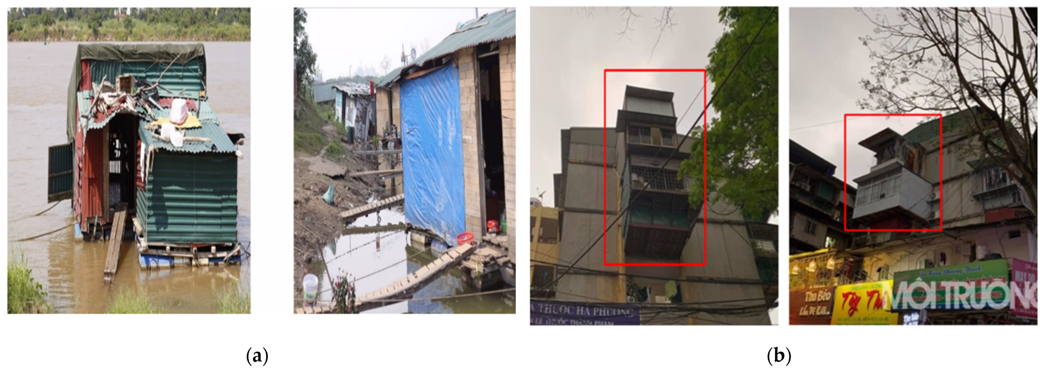
5.2.3. Hanoi Capital Region

With very early consciousness, Vietnam started DRR promotion under the President Ho Chi Minh since 1946 with its legal framework on floods and storms. It primarily focused on the country’s coastline protection and flood mitigation in the rural areas [75]. There are also attached ordinances for certain long-term disaster preventions, including also resettlement of the residents, who are living in the disaster-prone areas. All in all, these actions are still focused on the country’s rural area. As Nguyen and Tran indicated “These laws and regulations defined the functions and responsibilities of different agencies for disaster response, but there was little information and guidance about urban DRR” [75] (p. 127). Hanoi has developed Local Resilience Action Plans (LRAP) to improve resilience through infrastructure investments and capacity building [42] (p. 46).
From project cooperation with Vietnam, we obtained very rich information on the country’s policies and actions regarding DRRM, especially in the rural planning context. Scaling down to Hanoi itself, project experts remarked that it is hard to concretize Hanoi’s macro-level DRRM policies and problematic to apply them in reality. Reasons are multi-fold including:
(1)
Lack of reliable and accurate database to forecast and setting goals and strategies;
(2)
Only few detailed guidance has been legalized which are bases for execution; and
(3)
Lack of cooperative actions on planning natural disaster prevention among provinces, hence at the local level.
Vietnamese participants concluded that the root cause is that DRRM is not embedded into the provincial construction plan as well as the regional planning schemes (inter-provincial). Importantly, experts mentioned also international projects’ implementation is still sporadic and more experimental. It has not yet amounted the level for upscaling and replicating. In terms of local city level DRRM, our discussions are rather limited, let alone when touching issue of urban resilience upgrading. Several possible reasons may explain this limit. Above all, besides different understanding of informality, Hanoi has obviously less in-city informal settlements if compared with Metro Manila and Bangkok. Second, DRRM concept is observed mainly associated with rural settlements in Vietnam. Villages at Hanoi periphery are of particular informality. Village residents are living either on riverbanks or on boat, which is not accepted by the government. During the workshop, experts demonstrated the informal settlements in Dan Phuong rural district (Figure 12), lying on the west bank of Hong River in Hanoi periphery. Besides floods per se, the district is also prone to landslides. Issue of resettlement planning was extensively debated during our workshop as one of the planning intervention of DRRM. Another demonstrated residential area is in the urban Long Bien district of Hanoi, also along the Hong River (Figure 12). This area caught attention due to its emerging informality as a legacy of Hanoi’s urban expansion. Hanoi Land Registration Authority affirmed that due to district land administrative boundary changes during Hanoi’s urban expansion, the said Long Bien residents have not been officially recognized for a long time. Hence, they are informal settlers, who were left out in the urban planning process. The land they are residing now has been in-between planned for other development purposes. The change of land development is not mutually informed between residents and planning agencies due to residents’ unrecognized existence in the area. Right now, partial their dwelling lands are literally under the newly built river bridge. Initial obtained information during the workshop is a resettlement plan is proposed for the riverbank residents in Long Bien District, though they are unwilling to move elsewhere.
Notably, ca. 66.6% of population in Vietnam in 2019 was still dwelling in the rural areas [76]. As reviewed in Section 3.3, Vietnam’s fast urban expansion advanced the opportunity of transforming and integrating rural areas into urban centers. The process requires also to include the existing vulnerable and disaster-prone areas and their residents as well. Consequently, it demands timely review and update of land use plan in order to soundly react to its urban expansion impacts. Our experts emphasized: “Land use planning does not emphasize much on DRRM. Every five years there comes a brand new land use planning. How to link disaster scenario with land use? That’s the challenge. We don’t have a program of DRRM. There are some developed scenarios to show the local people. About public awareness, they are still ‘on the way there’. The information of the modelling is accessible to public now by mobile applications” (authors’ workshop in July 2021). It observes that DRRM urban attentions and actions fall short, if compared with other two metropolises.

5.3. Performance of On-Site Upgrading in Conjunction with Citywide Development

Authors’ last phase research project findings concluded that “There are very few good practices to convince both national and local government to elevate upgrading as a viable strategy regarding DRR and resilience building” in the Philippines [5] (p. 4). This results in the low priority of upscaling on-site upgrading and its convergence at the city and country policy level. Further, there is a dire need of involving local government in finding available sites and lands within their judiciary boundary for the ISFs. Besides land availability for ISFs, the observed common fact among the three metropolises is that cities developing faster than the planning laws and regulations. Local government and planning agencies render their zoning ordinances and land use regulations, which are not attuned to the increasing number of ISFs’ demands for lands. Taking the Philippines for example, in cases where CLUPs exist, the mandatory provision to incorporate city shelter plans for ISFs have not yet been complied. This planning gap leads to the isolation of ISFs’ settlements from the remaining urban development plan. Tran and Krause also indicated the policy drawback in this regard: “With regard to existing informal settlements in flood-prone areas, building institutional and technical capacity is central to rights-based and justice-driven slum upgrading efforts. Local governments must lead inclusive processes to create and maintain comprehensive urban upgrading plans at the city level and ensure coordination across the city’s districts” [77] (p. 17). In terms of institutional setup and city administration, the Philippines is distinct if compared with other Southeast countries. Namely, LGUs have the mandates of implementing housing and urban development projects. Since 1991 legislation of Local Government Code, LGUs of Metro Manila have been relatively autonomous. Thus, it enables LGUs to implement programs in urban development and housing with their own constituents. However, in Metro Manila context, the decentralization translated into the difficulty of bringing city government together [19] (p. 582). Metropolis-wide planning has not been in real practice, despite the master plan. Consequently, there are problems in development and housing programs implementation. It hampers the elevation of on-site upgrading to a city level.
As Section 3.2 revealed, Bangkok established its upgrading activities via Community Organization Development Institute (CODI) with a horizontal linkage between communities and cities. Therefore, as a result of horizontal linkages between communities within a city, member communities are not isolated; they are often able to jointly negotiate for their tenure and learn from others’ experiences [78]. As discussed in Section 4.2, CODI upholds collective housing concept with a demand-driven approach. It is tailor-made to meet community needs, which includes also improving access to basic services and employment opportunities on a citywide scale. There exists citywide surveys across communities. CODI tends to develop housing development plan at the city level, despite not necessarily being combined with resilience building. According to CODI’s own survey of the citywide Baan Mankong housing process in 2019 in 13 cities of Thailand, about 75% of insecure informal settlements in the cities had already taken part in the citywide housing program (3649 families participated in the survey) [34].
Workshop series in 2021 recast citywide development via discussing land readjustment in these three metropolises. Authors’ previous research summarized the usefulness of applying land readjustment to on-site upgrading. As a tool and solution of land management, land readjustment is not yet widely practiced in the context of informal settlements in Metro Manila. Further, involved Philippine stakeholders expressed they are not familiar with this tool [5]. According to De Souza et al., “Metro Manila Commission conducted a feasibility study (of land readjustment), but that was suspended due to the political instability in the country” [79] (p. 116). Though the tendency of applying this tool in other three countries appears higher (Figure 13), it remains unfavorable for on-site upgrading. Thailand has its national legislation enacted for land readjustment via introducing the “Land Readjustment Act, B.E. 2547 in 2004. There were budget allocations to land readjustment projects according to the Comprehensive City Planning Law. In Vietnam, the term of land readjustment is not found in either the Urban Planning Law 2009, or the newly enacted Land Law 2013” [79]. Nevertheless, workshop participants observed the critical challenges of applying land readjustment in an informal urbanization context. Particularly, how the targeted urban poor can benefit from it, while promoting citywide scale upgrading. Therefore, a particular tailor-made mechanism of land readjustment is suggested to be crafted and validated in the next phase research.

6. Conclusions and the Way Ahead

This research investigates informal settlement development dynamics and its resilience vis-à-vis the growth of the metropolis in which they are located. It examines informal settlement upgrading roles, mechanisms, and approaches for resilience building, and city-regional development needs. The intent is to highlight the pressing needs of mitigating the many aspects that impact the vulnerability of informal communities which are most adversely affected by climate change and rampant urbanization. With upgrading paradigm shift, the current informal settlement upgrading approach accentuates being city-led and community-driven with domestic funding. It unlocks great potentials for community resilience building, particularly among the countries and city-regions that consciously strive for an inclusive urban growth.
The common findings are all three metropolitan areas need to address geospatial aspects of hazard, exposure and vulnerability, risk patterns and its alliance with Comprehensive Land Use Plans (CLUP) and zoning ordinances. Further, on-site upgrading with consideration of future climatic and socioeconomic changes on disaster risks have to be addressed as well [80]. The Philippine National Urban Development and Housing Framework 2017–2022 highlights resilience as the foundation in planning and decision-making regarding spatial planning, e.g., thematically integrated settlements within coherent and efficient urban systems and forms across scales. Accordingly, the National Informal Settlements Upgrading Strategy 2018 raised the key approach to ISFs’ housing is incremental on-site upgrading through local government lead in strategic citywide urban planning. This key approach brought informal settlement on-site upgrading into a rational, which has not gained its significance in the last decades if compared with various resettlement actions regarding ISFs [81].
Participants pinpointed that ISFs perceive land tenure security and proximity (self-employment) as their top considerations related with both upgrading and retreat activities. However, the study observes that there needs a synergy and a convergence in terms of upgrading objectives and tenure status. In discussions of land tenure, it is important to separate formal titling from status of tenure security. Last generation upgrading program funded by the World Bank had the tendency to link upgrading process to the provision of land titles, such as Zonal Improvement Program (ZIP) in Metro Manila. Handzic’s research on Rio upgrading lessons revealed the downside of the traditional approach: “More worrisome, land tenure issues have been known to slow down the implementation of slum upgrading in some instances and stop them completely in others” [82] (p. 14).
Efficacy was seen on mainstreaming risk reduction and climate change in national comprehensive development plan for the purpose of influencing policy and decision making [83]. For instance, Philippine Housing and Land Use Regulatory Board (HLURB) guidelines already include guidance in mainstreaming DRRM in the comprehensive land use planning for sectors such as agriculture, power, water, and transport. Thai experts summarized certain potential step-in aspects regarding DRRM mainstreaming at the policy level, including Baan Mankong program, Thai 20-year housing development (2018–2038), etc. In Thailand, building codes in general are not discussed in the context of flood management or climate change. Mainstreaming DRRM also challenges Thai experts on how to apply their existing data of flood and draught events in regional scale to the urban context. How to revise the comprehensive spatial planning in response to climate change at the national scale is still under study and revision in Thailand. Efforts of mitigating impacts of disasters, especially those slow on-set disasters, are required for comprehensive spatial planning revision. The observations require that mainstreaming should be across multi-sectors at a multi-governance level. Particularly, stakeholders expect there should be an ultimate output in terms of policy impacts at the local level, which enables mainstreaming upgrading and resettlement or retreat strategies into the urban policy and spatial development. In the urban poor context, Thailand needs to consider how to advance by law planning tools and building regulations for requirement of affordable housing provision. In Vietnam, for example, a formal decree requires that all residential development set aside 20% of the total plot size for the construction of social housing for the poor [84]. In the Philippines, new projects should cover 30% of the development for the social housing. Vietnam steps further and enforces in the 2015 Housing Law “the framework for reform in the housing sector. Areas of particular importance in the Law is support toward self-built housing (…) addressing the shortage of affordable rental housing as well as high demand for housing from low income groups (…)” [85] (p. 11).
Overall, the results indicate that there continues to be a gap between scientific evidence and national policy goals for integrating DRRM and upgrading informal settlements on the one hand, and implementation in a concrete local context on the other. Therefore, the next step of the project is to develop and implement good examples of resilience upgrading, based on the selected informal settlements as case study and in cooperation with local stakeholders among the three metropolis city regions.

Author Contributions

This research article is supervised by S.G. Section 4.1 was written by D.L.T.Y., School of Urban and Regional Planning, University of the Philippines. Section 1 and Section 2 were written by S.G. Section 6 was jointly prepared by J.D., S.G. and D.L.T.Y. The rest of the draft and figures were prepared by J.D., Department of Spatial Planning of TU Dortmund University, Germany. All authors have read and agreed to the published version of the manuscript.

Funding

This research was funded by the German Federal Ministry of Education, and Research (BMBF) under the project “Linking Disaster Risk Governance and Land-use Planning: The Case of Informal Settlements in Hazard-prone Areas in the Philippines (LIRLAP)” with grant number 01LE1906A. The entire project consists of five work packages: Risk trends and resettlement options with urban growth, Resilience Upgrading, Resilient Retreat, Mainstreaming Upgrading and Retreat Strategies and Capacity Building. The five work packages are interdependent.

Institutional Review Board Statement

Not applicable.

Informed Consent Statement

Not applicable.

Data Availability Statement

Not applicable.

Conflicts of Interest

The authors declare no conflict of interest.

References

  1. Sendai Framework for Disaster Risk Reduction 2015–2030; United Nations Office for Disaster Risk Reduction (UNISDR): Geneva, Switzerland, 2015.
  2. UNHABITAT. The New Urban Agenda. Habitat III. 2017. Available online: https://habitat3.org/the-new-urban-agenda/ (accessed on 1 November 2020).
  3. United Nations. SDG Indicators -Goal 11: Make Cities and Human Settlements Inclusive, Safe, Resilient and Sustainable. 2020. Available online: https://unstats.un.org/sdgs/report/2020/goal-11/ (accessed on 11 January 2021).
  4. Mach, K.J.; Siders, A.R. Reframing strategic, managed retreat for transformative climate adaptation. Science 2021, 372, 1294–1299. [Google Scholar] [CrossRef] [PubMed]
  5. Du, J.; Greiving, S. Reclaiming On-Site Upgrading as a Viable Resilience Strategy-Viabilities and Scenarios through the Lens of Disaster-Prone Informal Settlements in Metro Manila. Sustainability 2020, 12, 10600. [Google Scholar] [CrossRef]
  6. Scott, M.; Lennon, M.; Tubridy, F.; Marchman, P.; Siders, A.; Main, K.L.; Herrmann, V.; Butler, D.; Frank, K.; Bosomworth, K.; et al. Climate Disruption and Planning: Resistance or Retreat? Plan. Theory Pr. 2020, 21, 125–154. [Google Scholar] [CrossRef] [Green Version]
  7. Greiving, S.; Du, J.; Puntub, W. Managed Retreat—A Strategy for the Mitigation of Disaster Risks with International and Comparative Perspectives. J. Extrem. Events 2018, 05, 1850011. [Google Scholar] [CrossRef]
  8. World Risk Report 2021; Ruhr University Bochum—Institute for International Law of Peace and Armed Conflict (IFHV): Bochum, Germany, 2021.
  9. Global Facility for Disaster Reduction and Recovery (GFDRR). GFDRR Annual Report 2017—Bringing Resilience to Scale—World. ReliefWeb. 2017. Available online: https://reliefweb.int/report/world/gfdrr-annual-report-2017-bringing-resilience-scale (accessed on 2 February 2022).
  10. Making Development Sustainable: The Future of Disaster Risk Management; United Nations Office for Disaster Risk Reduction (UNISDR): Geneva, Switzerland, 2015.
  11. World Bank. Philippines Urbanization Review: Fostering Competitive, Sustainable and Inclusive Cities. 2017. Available online: https://openknowledge.worldbank.org/handle/10986/27667 (accessed on 15 May 2021).
  12. Philippine Statistics Authority. Philippine Population Density. 2015. Available online: https://psa.gov.ph/content/philippine-population-density-based-2015-census-population (accessed on 10 May 2022).
  13. Estoque, R.C.; Murayama, Y. Intensity and Spatial Pattern of Urban Land Changes in the Megacities of Southeast Asia. Land Use Policy 2015, 48, 213–222. [Google Scholar] [CrossRef]
  14. Philippine Statics Authority. Highlights of the National Capital Region (NCR) Population 2020 Census of Population and Housing (2020 CPH)|Philippine Statistics Authority. 2021. Available online: https://psa.gov.ph/content/highlights-national-capital-region-ncr-population-2020-census-population-and-housing-2020 (accessed on 30 May 2022).
  15. Atlas of Urban Expansion—Manila. Available online: http://www.atlasofurbanexpansion.org/cities/view/manila (accessed on 26 May 2022).
  16. Naerssen, T. Urban Social Movements in the Third World, 1st ed.; Schuurman, F., Naerssen, T., Eds.; Routledge: London, UK, 1989. [Google Scholar] [CrossRef]
  17. Shatkin, G. Planning to Forget: Informal Settlements as “Forgotten Places” in Globalising Metro Manila. Urban Studies 2004, 41, 2469–2484. [Google Scholar] [CrossRef]
  18. Shatkin, G. The City and the Bottom Line: Urban Megaprojects and the Privatization of Planning in Southeast Asia. Environ. Plan. A. 2008, 40, 383–401. [Google Scholar] [CrossRef]
  19. Choi, N. Metro Manila through the gentrification lens: Disparities in urban planning and displacement risks. Urban Studies 2016, 53, 577–592. [Google Scholar] [CrossRef]
  20. UNHABITAT. Slums of the World: The Face of Urban Poverty in the New Millennium. 2003. Available online: https://unhabitat.org/slums-of-the-world-the-face-of-urban-poverty-in-the-new-millennium (accessed on 6 May 2022).
  21. Habitat-III-Issue-Paper-22_Informal-Settlements-2.0 (2). Available online: https://unhabitat.org/sites/default/files/download-manager-files/Habitat-III-Issue-Paper-22_Informal-Settlements-2.0%20%282%29.pdf (accessed on 6 May 2022).
  22. Philippine Development Plan 2011–2016; National Economic and Development Authority (NEDA): Pasig City, Philippines, 2011.
  23. Morin, V.M.; Ahmad, M.M.; Warnitchai, P. Vulnerability to typhoon hazards in the coastal informal settlements of Metro Manila, the Philippines. Disasters 2016, 40, 693–719. [Google Scholar] [CrossRef] [PubMed]
  24. National Economic and Development Authority (NEDA). Philippine Development Plan 2017–2022. (abridged version); 2017. Available online: http://www.neda.gov.ph/wp-content/uploads/2017/12/Abridged-PDP-2017-2022_Final.pdf (accessed on 1 November 2020).
  25. ICF (2014). Developing a National IFs Upgrading Strategy for the Philippines-Final Report. 2014. Available online: https://www.google.com/search?q=ICF+(2014).+Developing+a+National+IFs+Upgrading+Strategy+for+the+Philippines-+Final+Report&oq=ICF+(2014).+Developing+a+National+IFs+Upgrading+Strategy+for+the+Philippines-+Final+Report&aqs=chrome..69i57.1431j0j7&sourceid=chrome&ie=UTF-8 (accessed on 10 January 2021).
  26. World Bank. Climate Risks and Adaptation in Asian Coastal Megacities: A Synthesis. Yumpu.com. 2010. Available online: https://www.yumpu.com/en/document/view/45806137/climate-risks-and-adaptation-in-asian-coastal-megacities-a-synthesis (accessed on 6 May 2022).
  27. World Bank. Climate Change Impact and Adaptation Study for Bangkok Metropolitan Region: Final Report; World Bank: Washington, DC, USA, 2009; Available online: https://openknowledge.worldbank.org/handle/10986/3113 (accessed on 16 May 2022).
  28. Atlas of Urban Expansion—Bangkok. Available online: http://www.atlasofurbanexpansion.org/cities/view/Bangkok (accessed on 24 May 2022).
  29. Burapatana, T.; Ross, W. Chapter 7. Bangkok: Suburbanizing and Unsustainable. Environ. Nat. Resour. J. 2007, 5, 59–68. [Google Scholar]
  30. Statistical Profile of Bangkok Metropolitan Administration; Strategy and Evaluation Department Bangkok Metropolitan Administration: Bangkok, Thailand, 2016.
  31. Kermel-Torrès, D. (Ed.) Bangkok and the Bangkok Metropolitan Region. In Atlas of Thailand: Spatial Structures and Development, Atlas et cartes, IRD Éditions; Silkworm Books: Chiang Mai, Thailand, 2020; pp. 151–159. Available online: http://books.openedition.org/irdeditions/32577 (accessed on 23 May 2022).
  32. World Bank. Population Living in Slums—Thailand|Data. 2020. Available online: https://data.worldbank.org/indicator/EN.POP.SLUM.UR.ZS?end=2017&locations=TH&st=null (accessed on 10 May 2022).
  33. Bangkok Communities Statistical Report; Bangkok Metropolitan Administration: Bangkok, Thailand, 2018. (In Thai)
  34. Baan Mankong Thailand’s National, Peopledriven, Collective Housing Program; Community Organizations Development Institute (CODI): Bangkok, Thailand, 2019.
  35. Yap, K.S.; Leeruttanawisut, K. Informal Settlements in Bangkok: Origins, Features, Growth and Prospects; Routledge: London, UK, 2017. [Google Scholar]
  36. Kamalipour, H. Forms of informality and adaptations in informal settlements. ArchNet-IJAR 2016, 10, 60. [Google Scholar] [CrossRef]
  37. Endo, T. Living with Risk: Precarity & Bangkok’s Urban Poor; NUS Press: Singapore, 2014. [Google Scholar] [CrossRef]
  38. Burapatana, T.; Ross, W. Improving the Quality of Life in Bangkok via Change in City Planning. J. Popul. Soc. Stud. 2011, 20, 25–42. Available online: https://so03.tci-thaijo.org/index.php/jpss/article/view/84529 (accessed on 2 February 2022).
  39. World Bank Group; Asian Development Bank. Climate Risk Country Profile: Vietnam; World Bank: Washington, DC, USA, 2021. [Google Scholar] [CrossRef]
  40. Leducq, D.; Scarwell, H.J. The New Hanoi: Opportunities and Challenges for Future Urban Development. Cities 2018, 72, 70–81. [Google Scholar] [CrossRef]
  41. Duan, H.D.; Shibayama, M. Studies on Hanoi Urban Transition in the Late 20th Century Based on GIS/RS. Jpn. J. Southeast Asian Studies 2009, 46, 532–546. [Google Scholar] [CrossRef]
  42. Nguyen, T.; Lin, T.H.; Chan, H.P. The Environmental Effects of Urban Development in Hanoi, Vietnam from Satellite and Meteorological Observations from 1999–2016. Sustainability 2019, 11, 1768. [Google Scholar] [CrossRef] [Green Version]
  43. Minnery, J.; Argo, T.; Winarso, H.; Hau, D.; Veneracion, C.C.; Forbes, D.; Childs, I. Slum upgrading and urban governance: Case studies in three South East Asian cities. Habitat Int. 2013, 39, 162–169. [Google Scholar] [CrossRef]
  44. Ngo, K.; Gao, Y. Transformation of urban villages in the city of Hanoi, Vietnam. In Health: The Design, Planning and Politics of How and Where We Live; Architecture Media Politics Society: Bristol, UK, 2018; pp. 53–63. Available online: https://pure.hud.ac.uk/en/publications/transformation-of-urban-villages-in-the-city-of-hanoi-vietnam (accessed on 16 May 2022).
  45. Quezon City: The People’s Homesite and Housing Projects—Lakbay ng Lakan. Available online: https://lakansining.wordpress.com/2020/01/30/quezon-city-the-peoples-homesite-and-housing-projects/ (accessed on 31 May 2022).
  46. BLISS-Bagong Lipunan Improvement of Sites and Services. Available online: https://kbl.org.ph/bliss-bagong-lipunan-improvement-of-sites-and-services/ (accessed on 31 May 2022).
  47. Compilation of Research Studies on the Upgrading Projects in Metro Manila; National Housing Authority: Bangkok, Thailand, 1985.
  48. Republic Act No. 7279; Congress of the Philippines: Manila, Philippines, 1992.
  49. Doherty, J.F. The Philippine Urban Poor. 1985. Available online: http://hdl.handle.net/10125/15294 (accessed on 2 June 2022).
  50. Typhoon Ketsana. Wikipedia. 2022. Available online: https://en.wikipedia.org/w/index.php?title=Typhoon_Ketsana&oldid=1087677253 (accessed on 31 May 2022).
  51. High Density Housing Program—Social Housing Finance Corporation. Available online: https://www.shfc.dhsud.gov.ph/high-density-housing-prgm/ (accessed on 2 June 2022).
  52. Novero, J.A.S.; Solidum, M.A.B. A Case Study of the Bago Aplaya Settlers Homeowners Association (BASHA), Davao City; BASHA: Davao City, Philippines, 2021. [Google Scholar]
  53. Fast Facts—Social Housing Finance Corporation. Available online: https://www.shfc.dhsud.gov.ph/cmp-fast-facts/ (accessed on 2 June 2022).
  54. Ballesteros, M.M.; Llanto, G. Social Inclusion and Housing: Evidence from the Philippines—PDF Free Download. Available online: https://docplayer.net/28078189-Social-inclusion-and-housing-evidence-from-the-philippines.html (accessed on 2 June 2022).
  55. Congress of the Philippines. Republic Act No. 9207|GOVPH. Official Gazette of the Republic of the Philippines. 2002. Available online: https://www.officialgazette.gov.ph/2003/05/17/republic-act-no-9207-2/ (accessed on 31 May 2022).
  56. Congress of the Philippines. R.A. No. 10023. 2009. Available online: https://lawphil.net/statutes/repacts/ra2010/ra_10023_2010.html (accessed on 31 May 2022).
  57. Congress of the Philippines. Republic Act No. 10752. 2015. Available online: https://lawphil.net/statutes/repacts/ra2016/ra_10752_2016.html (accessed on 31 May 2022).
  58. Cipriano, F.; Ledda, K.M. A Case Study on Isf Resilience Upgrading: Community Development Initiatives and Programs of Riverview Homeowners Association, Inc. (RVHOA) in Iloilo City; RVHOA: Iloilo City, Philippines, 2021. [Google Scholar]
  59. Dadulla, L.B.; Esplana, I.R. A case study of Del Rosario Compound Neighborhood Association, Inc. (DRCNAI); DRCNAI: Valenzuela City, Philippines, 2021. [Google Scholar]
  60. De Rosas-Ignacio, M.A. Credit and Savings Cooperative (K-COOP), Kabuhayan sa Ganap na Kasarinlan (KASAGANA KA); KASAGANA KA: Quezon, Philippines, 2020. [Google Scholar]
  61. Adarne, F.I.A.; Salazar, A.E.R.U. Approaches to Resilience Upgrading in ISF Communities: A Case of Ang Payatas Scavengers Homeowners Association, Inc. (APSHAI); APSHAI: Barangay, Philippines, 2021. [Google Scholar]
  62. Senanuch, P. An Investigation into the Policy for Urban Poverty Alleviation in Thailand through the Study of Urban Slum Communities. Ph.D. Thesis, The University of Sydney, Sydney, Australia, 2004. Available online: https://ses.library.usyd.edu.au/handle/2123/1982 (accessed on 16 May 2022).
  63. Yap, K.S.; De Wandeler, K. Self-Help Housing in Bangkok. Habitat Int. 2010, 34, 332–341. [Google Scholar] [CrossRef]
  64. Doling, J. Housing Policies and the Little Tigers: How Do They Compare with Other Industrialised Countries? Hous. Stud. 1999, 14, 229–250. [Google Scholar] [CrossRef]
  65. Jonsson, H. Review of Inside Thai Society: Religion, Everyday Life, Change. J. Asian Studies 2002, 61, 784–786. [Google Scholar] [CrossRef]
  66. Garschagen, M. Urban Upgrading and Resettlement of Slum Dwellers in the Mekong Delta—Long-Term Sustainability or Vulnerability Pitfall? In Proceedings of the International Workshop on Socio-Economically Sustainable Development in Vietnam, Hanoi, Vietnam, 1–3 December 2010; p. 14. [Google Scholar]
  67. Anh, N.T.; Minh, P.Q. Responses to Flooding: Migrants’ Perspectives in Hanoi, Vietnam. In Living with Floods in a Mobile Southeast Asia; Routledge: London, UK, 2017. [Google Scholar]
  68. World Bank. Vietnam’s Urbanization at a Crossroads: Embarking on an Efficient, Inclusive, and Resilient Pathway; World Bank: Washington, DC, USA, 2020. [Google Scholar] [CrossRef]
  69. Kimhur, B. When Communities Transform Old Socialist Housing into Adequate Housing—Part 1. Urbanet. 2019. Available online: https://www.urbanet.info/when-communities-transform-old-socialist-housing-into-adequate-housing-part-1/ (accessed on 12 May 2022).
  70. United Nations Office for Disaster Risk Reduction (UNDRR). Global Assessment Report on Disaster Risk Reduction 2019; UN Office for Disaster Risk Reduction. 2019. Available online: http://digitallibrary.un.org/record/3825375 (accessed on 23 November 2020).
  71. The National Disaster Risk Reduction and Management Plan; The National Disaster Risk Reduction & Management Council (NDRRMC): Quezon City, Philippines, 2011; p. 69.
  72. Closing the Gap in Affordable Housing in the Philippines: Policy Paper for the National Summit on Housing and Urban Development; World Bank: Washington, DC, USA, 2016.
  73. Rerngnirunsathit, P. Thailand Country Profiles 2011; DDPM: Bangkok, Thailand, 2012; p. 23. [Google Scholar]
  74. Bangkok Urban Planning and Development & Climate Resilient Integration; BMA City Planning and Urban Development Department: Bangkok, Philippines, 2020.
  75. Nguyen, H.; Tran, P. Urban Disaster Risk Reduction in Vietnam. In Urban Disasters and Resilience in Asia; Elsevier: Amsterdam, The Netherlands, 2016; pp. 123–140. [Google Scholar] [CrossRef]
  76. Statista. Vietnam: Distribution of Population between Urban and Rural Areas. Statista. 2020. Available online: https://www.statista.com/statistics/1195077/vietnam-population-distribution-between-urban-and-rural-areas/ (accessed on 19 May 2022).
  77. Tran, M.; Krause, D. Transformative Adaptation to Climate Change and Informal Settlements in Coastal Cities: Entry Points for Jakarta and Ho Chi Minh City; UN Research Institute for Social Development: Geneva, Switzerland, 2019; p. 30. [Google Scholar]
  78. Bhatkal, T.; Lucci, P. Community-Driven Development in the Slums: Thailand’s Experience. ODI, 12 June 2015; 8. [Google Scholar]
  79. De Souza, F.; Ochi, T.; Hosono, A. Land Readjustment: Solving Urban Problems Through Innovation; JICA Ogata Research Institute: Tokyo, Japan, 2018.
  80. Greiving, S.; Arens, S.; Becker, D.; Fleischhauer, M.; Hurth, F. Improving the Assessment of Potential and Actual Impacts of Climate Change and Extreme Events Through a Parallel Modeling of Climatic and Societal Changes at Different Scales. J. Extrem. Events 2017, 04, 1850003. [Google Scholar] [CrossRef]
  81. Consulting Services for the Formulation of the Manila Bay Sustainable Development Master Plan. Focal Theme Report: Upgrading Informal Settlements. In Manila Bay Sustainable Development Master Plan Situation Analysis Report. 2018. Available online: http://mbsdmp.com/reports (accessed on 18 May 2022).
  82. Handzic, K. Is legalized land tenure necessary in slum upgrading? Learning from Rio’s land tenure policies in the Favela Bairro Program. Habitat Int. 2010, 34, 11–17. [Google Scholar] [CrossRef]
  83. National Economic and Development Authority. Mainstreaming disaster risk reduction in subnational development and land use/physical planning in the Philippines. Preven-tionWeb.net-The Knowledge Platform for Disaster Risk Reduction. 2008. Available online: https://www.preventionweb.net/publications/view/11433 (accessed on 24 November 2020).
  84. Baker, J.L.; Gadgil, G.U. East Asia and Pacific Cities: Expanding Opportunities for the Urban Poor; World Bank: Washington, DC, USA, 2017. [Google Scholar] [CrossRef]
  85. Vietnam Affordable Housing-A Way Forward; World Bank: Washington, DC, USA, 2015; Available online: https://openknowledge.worldbank.org/bitstream/handle/10986/22921/Vietnam000Affo0sing000a0way0forward.pdf?sequence=1&isAllowed=y (accessed on 18 May 2022).
Figure 1. (a) Multi-hazard types in Metro Manila, the Philippines; and (b) Metro Manila boarders province of Bulacan to the north and Rizal to the east. The green circles indicate respectively Marikina City and Manila City. Source: own GIS spatial analysis based on OSM open access data, 2022.
Sustainability 14 08985 g001
Figure 2. Population density and distribution comparisons. (a) Greater Manila Area; (b) Bangkok Metropolitan Region (BMR); and (c) Hanoi Capital Region. Source: Own modification based on (2015) World Human Settlement, resolution 10 × 10 m, 2021.
Sustainability 14 08985 g002
Figure 3. Administrative boundaries of Bangkok Metropolitan Region (BMR) and Bangkok Metropolitan Area (BMA). Two indicated upgrading hotspots by Thai participants during the workshop in 2021, namely: Lat Phrao area and Kholong Toey area. The figure also shows the city’s historic center is on the eastern bank of the Chao Phraya River, where Kholong Toey is located. Source: Own GIS spatial analysis based on GADM and OSM open data, 2022.
Sustainability 14 08985 g003
Figure 4. Very similar locations of informal settlements: (a) Khlong Toey District in Bangkok port area; and (b) Isla Putting Bato built on the water break at Metro Manila port area. Source: Own modification based on Google Earth, 2022.
Sustainability 14 08985 g004
Figure 5. Hanoi consisted of four urban districts in the period of 1940s–1950s, centered around the West Lake. In 2008, Hanoi Capital Region’s administrative boundary expanded to the west. Source: Own GIS spatial analysis based on GADM and OSM open data sources, 2022.
Sustainability 14 08985 g005
Figure 6. Informal settlement types: (a) In-city disaster-prone informal settlement Xom Lieu community in Phuc Xa Ward (Ba Dinh District) located in the inner Hanoi along the Red River; (b) Dilapidated housing stock from socialism era, now with illegal extending. Source: Project internal materials from the stakeholder workshop with Vietnam experts, July 2021.
Sustainability 14 08985 g006
Figure 7. Results regarding the question of “what are possible future scenarios for informal settlement upgrading strategies in consideration of the current pandemic?”. Source: Results of authors’ pre-workshop online questionnaire via LimeSurvey in September, 2020.
Sustainability 14 08985 g007
Figure 8. Real-time Zoom polling results regarding the question of “In terms of disaster resilience, which aspect(s) is/are integrated in addressing urban poor’s housing in your city or region?”. Source: Results of the authors’ Resilience Upgrading Online Validation Workshop on 8 October 2020.
Sustainability 14 08985 g008
Figure 9. Real-time Zoom polling results regarding the question of “In terms of disaster resilience, which aspect(s) is/are integrated in addressing urban poor’s housing in your city or region?”. Source: Results of the authors’ Resilience Upgrading Online Validation Workshop on 8 October 2020.
Sustainability 14 08985 g009
Figure 10. Results regarding the question of “How is the performance of informal settlement on-site upgrading regarding disaster resilience planning in Vietnam, Thailand and Indonesia? Source: Results of authors’ pre-workshop online questionnaire via LimeSurvey in September 2020.
Sustainability 14 08985 g010
Figure 11. Results regarding the question of “Based on your experience, what are the critical challenges in identifying ISFs’ needs in terms of informal settlement upgrading?”. Source: Results of authors’ pre-workshop online questionnaire via LimeSurvey in September 2020.
Sustainability 14 08985 g011
Figure 12. (a) Hanoi study sites’ investigation during the cross-country stakeholder workshop in July, 2021; and (b) Google Earth image of the discussed river bank informal community in urban district Long Bien, Hanoi. Source: Own GIS spatial analysis based on GADM and OSM open data sources, 2022.
Sustainability 14 08985 g012
Figure 13. Results regarding the question of “Which strategy(s) could be technically and financially implementable to build community resilience in informal settlements in your city/region?”. Source: Results of authors’ pre-workshop online questionnaire via LimeSurvey in September 2020.
Sustainability 14 08985 g013
Publisher’s Note: MDPI stays neutral with regard to jurisdictional claims in published maps and institutional affiliations.

