Abstract
The increasing population in Indonesia is challenging rice production to feed more people while rice fields are being converted to other land-use land cover (LULC). This study analyzes land use in 2015, 2017, 2019, 2021, and 2025 using an artificial neural network cellular automata (ANN-CA) and rice data from Statistics Indonesia to predict future rice status in Malang Districts, Indonesia. The primary LULC change driver was the rapid conversion of rice fields, which had their area reduced by 18% from 2019 to 2021 and 2% from 2021 to 2025. Rice fields are mainly being converted to settlements and buildings. The Kappa coefficient of simulation achieved 88%, with 91 accuracies. The model predicted a 2% lower rate of rice production but a 3% higher demand in 2025 compared to 2021. Lower rice production and higher demand are predicted to reduce the rice surplus by 57% in 2025, suggesting that the Malang district might lower its supply of rice to other areas by 2025. Our study provides a food crisis early warning system that decision makers can use to form adequate strategic plans and solutions to combat food insecurity.
1. Introduction
Food security is a critical issue in developing countries, especially those with a high population density, such as Indonesia. As rice is the most important commodity in Indonesia, domestic rice production should provide a foundation for food sovereignty and security in the aim to achieve zero hunger, which is in line with the Sustainable Development Goals (SDGs) [1,2]. With a track record of success in achieving rice self-sufficiency in the early 1980s [3], it should be possible to regain power regarding rice self-sufficiency in Indonesia through comprehensive approaches such as crop improvement, staple food diversification, policies that prevent the conversion of rice fields to other uses, and family planning to control population growth.
The Law of the Republic of Indonesia Number 18 of 2012 guarantees food security to the Indonesian people [4,5], but meeting rice demand through domestic rice production in Indonesia is not easy. Rice production is challenged by a continuously growing population, land-use changes, and limited access to innovation, technologies, and resources. Coping with these challenges requires information on the characteristics and dynamics of past and current rice production systems, such as changes in land use and land cover (LULC), rice productivity per unit area, and rice supply and demand. In turn, information on the characteristics and dynamics of rice production systems can be used to explore, plan, and construct food security scenarios [6]. These scenarios are helpful in the prediction of rice production and demand, and inform the development of policies and actions to prevent food insecurity. Information on rice production systems is usually collected through conventional approaches such as surveys and censuses. However, both approaches are expensive and time-consuming, leading to significant gaps in the time between surveys and impeding the appropriate formulation of strategic plans for public policies to safeguard food security.
Alternatively, a remote sensing approach can be a powerful tool to cope with these challenges. Remote sensing has the potential to cover large geographic areas and provide high temporal coverage by recording and analyzing data on past and present LULC. Remote sensing uses space-based satellites to classify the LULC on earth, effectively identifying various environmental characteristics, such as vegetation cover, urban sprawl, forest changes, and other variations in LULC changes over time [7,8]. Compared to the survey and census approaches, remote sensing could provide more reliable and cost-effective data collection and assessment [9].
In combination with an artificial neural network cellular automata (ANN-CA), satellite images of LULC can be simulated and analyzed to predict future LULC. The concept of ANN-CA was developed in the 1940s in the computer field by Ramírez as a discrete-dynamics system, a method of mimicking the human brain in a computer to allow for the computer to learn from experience in the same way as humans. ANN-CA has spaces divided into spatially ordered cells, and time is processed at each stage [10,11]. This concept is a systematic model designed to explain the probability of a future event using previous events [12]. Each cell in this system has one condition, and this condition is constantly updated according to local rules, the given time, its state, and the state of its neighbors [13]. The advantage of the ANN-CA model is that it can be used to study a complex pattern using simple principles [14,15].
In this present study, the ANN-CA remote sensing approach is used to obtain data on LULC changes that can be simulated and analyzed to predict future rice availability in 2025. Previous studies show that the ANN-CA model can be an effective and accurate tool to detect future changes in LULC [16,17]. Although several studies provide rice production predictions, it is still unclear how cellular automata and satellite images can be combined to derive fast and accurate recommendations to promote food security in the face of socio-ecological changes, especially when considering LULC interventions such as roads and built-up areas, which reduce rice field area and other factors [18]. In our study, we try to fill this gap by addressing the following research questions: (i) What changes in LULC occurred in the Malang District? (ii) What are the implications of rice field LULC changes for rice status? (iii) Can the Malang District maintain a rice surplus in the future? The results can be used as an early warning system for future food security. Finally, this reliable but cheap tool could create a robust monitoring, analysis, and prediction system to safeguard food sovereignty and security in the short and long term.
2. Materials and Methods
2.1. Study Area
The study was conducted in Malang District, East Java Province, Indonesia, at 112°17′ to 112°57′ E and 7°44′ to 8°26′ S (Figure 1). Malang District covers 345,383 ha, including a large area of rice fields that have experienced a shrinking trend over the years. Despite the creation of new rice fields, existing rice fields are continuously converted to settlements and other uses, especially those with good access to roads, due to the growing population and immigration waves [19]. In 2015, the average rice productivity in Malang was about 6.4 tons ha−1 per cropping cycle, and consumption rates per capita were 94.9 kg per year [20]. The spatial distribution of rice fields in Malang in 2015, 2017, 2019, and 2021 was been well recorded (in terms of resolution and image quality) in Sentinel 2-A [21], which was used in this study to accurately estimate the growth in the built area and rice field changes [22].
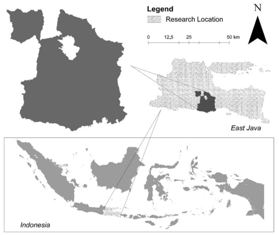
Figure 1.
Map of study site.
2.2. Sentinel 2-A Data Collection and Pre-Processing
To analyze LULC 2015, 2017, 2019 and 2021, Sentinel 2-A images were downloaded from the USGS (https://usgsexplorer.com, accessed on 15 May 2021). The determination of the location (path and row) was adjusted to the boundaries of the Malang District. Eight of the best screen image layers were selected from the downloaded images to cover the entire Malang district. The Sentinel 2-A images were taken in May–June, considering that, in that month, the rice entered the vegetative phase II (which is very clear to identify). We used good-quality images. The Sentinel 2-A images were atmospherically and radiometrically corrected before further processing [23]. The image had 13 wave channels (visible, near-infrared, and short wave infrared sensors) and was produced in 2015 [24], and remained accessible until this study was performed. This radiometric correction approach was used, based on the following formula:
where is the vignette polynomial function for xy pixel; 1, 2, and 3 are the radiometric calibration coefficients; is the normalized raw pixel value; BL is the normalized black level value; G is the sensor gain setting; te is the image exposure time; and L is the spectral radiance in W m−2 sr−1 nm−1.
Meanwhile, atmospheric correction was carried out using the formula:
with as the spectral radiance of atmospheric correction, as the total downwelling radiance, as the reflectance of the target, as the atmospheric transmittance, and as the atmospheric path radiance [25].
All the pre-processing processes (radiometric and atmospheric) were performed using image analysis in ArcMap 10.6.
2.3. LULC Classification and Accuracy Assessment
The land use-land cover classification of four different year images (i.e., for 2015, 2017, 2019, and 2021) was carried out using an unsupervised image analysis method [26]. Images were analyzed in ArcMap 10.6 [27] using the image analysis with a K-mean factor and 100 level classes. The identified LULC types included forest, production forest, bush, agroforestry, paddy fields, other agricultural land, settlements, water bodies, and ponds. The classified LULC maps were tested for accuracy using the Kappa coefficient [28] on 100 location points, which were determined using random stratified sampling [29] (Figure 2).
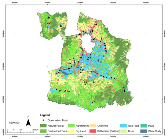
Figure 2.
Validation points map with land use-land cover background classified (unsupervised) in 2021.
2.4. LULC Simulation and Changes
The future of LULC was predicted using QGIS 2.18, following the cellular automata plugin model [30]. Based on the Euclidean distance analysis and various studies, the driving factors of land-use changes include settlements and road networks that provide convenient access to many places [31,32]. The higher the Euclidean value, the lower the potential for change [33]. This Euclidean distance value was calculated as follows:
where 𝑑(𝑖, 𝑗) is the Euclidean distance, 𝑋𝑖1 is the first point’s values, 𝑋𝑗2 is the second point’s value, and 𝑋𝑗p is the last point’s value [34].
(𝑖, 𝑗) = √|𝑋𝑖1 − 𝑋𝑗1|2 + |𝑋𝑖2 − 𝑋𝑗2|2 + ⋯ + |𝑋𝑖𝑝 − 𝑋𝑗𝑝|2
The land-use changes in 2015, 2017, and 2019 were simulated using settlement and road networks [35]. As the initial year, land-use change in 2021 was simulated and validated with the 2021 land-use map from the unsupervised classification [36]. As the validation results (overall kappa) were over 80% [10], the model was similarly used to predict land use in 2025. The Kappa coefficient was calculated using the formula confirmed and used by Congalton and Green [37] and Wang [27]:
where is the code number, is the class number, is the total number of classified pixels that are compared to actual data, nii is the number of the actual data class pixels that were classified with class , is the total number of classified class pixels, and is the total number of actual data class pixels.
The spatial allocation of land use in 2025 was determined using cellular automata based on an ANN-CA in the Mollusce QGIS 2.18 plug-in [38]. The land use in 2025 was modeled using ANN-CA, which uses the human brain in thinking mechanisms [39], in four steps: (1) determining the input and network architecture, (2) training the network, (3) testing the data network, and (4) predicting future land use based on information from previous steps [40].
2.5. Data Collection and Quantification of Rice Status
The rice grain yield data for model training and testing were obtained from Statistics Indonesia [20]. The dataset included an average rice grain yield (tons ha−1) centered in 2019–2021 based on census data. We used raster data with no spatial gaps inside the extent, assuming that the entire area within a grid cell has the same value. The raster data layers were transformed into polygon data and spatially joined to each other based on the centroid of each grid cell by a Geographical Information System (GIS) program, ArcGIS 10 [41].
The rice supply (production) and demand were calculated using the dataset of rice mean yield per hectare (productivity) per cropping season, total planted area per cropping season, rice consumption per capita, population growth rates, and total population, centered on the year 2021. Statistics Indonesia 18 was used to extract data at the sub-district level. After calculation, the data were used for model training and testing to generate future rice demand, supply, and required fields in 2025. The rice supply was calculated using the following formula:
where is dry grain production (tons ha−1), S is seed factor (0.9%), F is rice bran (0.44%), W is 5.4% of scattered grains on the field and during transportation, and C is the conversion from grain to rice (53.37%) [20] (Food Security Institution, 2015). Meanwhile, rice demand for rice consumption was calculated using the formula: population density × 94.9 kg capita−1 year−1, where 94.9 is the rate of Indonesian rice consumption per capita per year [20] (Ministry of Agriculture, 2021). Additionally, the field area required to grow enough rice to meet the demand for rice consumption in Malang Regency was calculated using the formula:
The surplus or deficit of rice was calculated from the subtraction of rice supply from rice demand. If the value was positive, the rice status in the area was a surplus, while a negative value indicated a deficit.
To predict rice demand in 2025, the population of Malang Regency in 2025 and the population growth rate were used to calculate the formula. Pn provides information on the total population in year n, where Po is the total population in the base year (2015), n is the number of base years up to n, and r is the population growth rate per year (%). With the assumption that rice productivity per hectare is the same over the years, this population number, with its consumption rate per capita, can be used to calculate the field area required to grow enough rice to meet the demand in 2025. The required field area to produce rice in 2025 was predicted based on rice productivity and demand in 2025. Thus, the shortage of rice fields can be predicted by the differences between required rice fields and the predicted rice field area in 2025.
3. Results
3.1. LULC Classification and Changes
In 2015, agriculture was identified as the main land use in Malang (345,383 ha). The dominant types of agricultural systems were agroforestry (97,268 ha), dry agricultural lands (71,167 ha) and rice fields (50,332 ha). Natural forest was identified as the second largest (80,006 ha) land use in Malang, followed by production forest (22,253 ha) and settlement (16,783 ha). Following a similar structure as that used in 2015, the unsupervised LULC classification from the satellite images in 2021 resulted in the identification of 10 LULC types in Malang. More than 60% of the area was dominated by natural forests, production forests, and dry agricultural lands. The flooded rice field was the fourth most dominant LULC after the natural forest, agroforestry, and dry agricultural lands.
Comparisons between the multiple-temporal datasets (2015–2021) revealed several changes in land-use configuration. On the one hand, the area occupied by natural forests decreased by 14%. On the other hand, the area occupied by settlements increased by 53%. Regarding agricultural lands, agroforestry LULC increased by 5%, while agricultural dry land LULC was relatively constant. However, rice field LULC was reduced by 18% in 2021 from 2019 and by 15% from 2015 (Figure 3 and Figure 4). Details of 10 LULC changes from 2015 to 2021 are presented in Figure 3 and Figure 4.
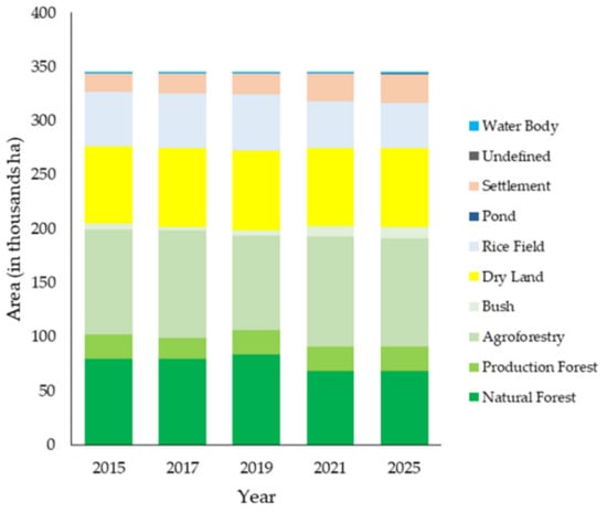
Figure 3.
LULC changes from 2015 to 2025.
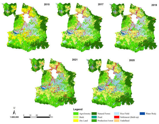
Figure 4.
LULC changes in Malang District from 2015 to 2025.
3.2. Prediction of LULC Changes in 2025 Transitional Neural Network and Model Validation
Based on Sentinel 2-A Imagery of the Malang District in 2015, 2017, 2019, and 2021, which used the distance between LULC types and the road and the distribution pattern of built settlements as the drivers of LULC changes, the Euclidean distance values were obtained, ranging from 0 to 7879 for roads and from 0 to 7272 for settlements (Figure A1). The Euclidean analysis reflects the potential impact, suggesting that the higher the value, the smaller the chance to change. The Neural Network graph that simulated prediction and actual LULC changes for 2025 in this study show that the predicted LULC was in line with the actual LULC, suggesting a good fit between the LULC predicted for 2025 and the actual LULC (Figure 5). This is supported by the results of the Kappa analysis, showing that the percentage correctness of the ANN-CA-based simulation map has an accuracy rate of 91%, with a Kappa statistical value of 0.88 (Figure A2). These values indicate a strong agreement between the prediction and the actual LULC [42]. Thus, overall, LULC 2025 was predicted with a high degree of accuracy.
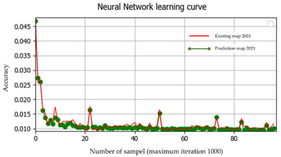
Figure 5.
The neural network learning curve graph.
Comparing model output to LULC 2021 reveals that the prediction of LULC changes to natural forests, production forests, water bodies, and agricultural dry lands are relatively constant. Meanwhile, rice fields and agroforestry are predicted to decline by 2% and 1%, respectively. Finally, settlement area is predicted to increase by 4% in 2025 (Figure 6). Considering the higher correctness and kappa values, these ANN outputs can be used to predict rice status in 2025.
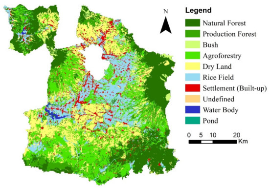
Figure 6.
LULC prediction in 2025 using ANN-Markov Cellular Automata.
3.3. Rice and Rice Field Status in Malang District
The future of rice field LULC changes and rice production in 2025 was predicted based on LULC map images and ANN-CA outputs, combined with rice productivity data, rice consumption per capita, and population, as obtained from Statistics Indonesia [20]. Although rice production increased in 2017 and 2019, there was an overall reduction in rice field area from 2015 to 2021. In addition, a sharp decline in rice production was observed from 2019 to 2021. An increase in rice supply in 2017 and 2019 was also followed by rice production enhancement (Table 1).

Table 1.
Rice production, productivity, supply and demand in Malang.
Contrary to the overall decline in rice field LULC and rice production, the population and rice demand are continuously increasing. With rice demand increased by 17,851 tons in 2021 compared to 2015, rice surplus status in the Malang district experienced a decline of 134,356 from 2015 to 2021 (Table 1 and Figure 7).
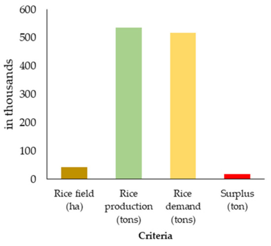
Figure 7.
Predicted rice status in 2025.
Rice field LULC and rice production are predicted to be 2% lower in 2025 than in 2021; rice production is also expected to be lower by 2025. As a consequence of the continuously growing population, a 3% increase in rice demand will occur from 2021 to 2025. This will lead to a reduction in the rice surplus by 57% from 2015 to 2021 (Figure 6).
4. Discussion
The present study identified three general types of agricultural LULC, including agroforestry, dry agricultural land, and rice field. Other important land uses include natural forest, settlement, waterbody, bush, and unidentified land and agricultural lands. Moreover, the study also assessed the effects of rice field LULC changes on the rice status in the Malang District. One important finding is that, despite the dry agricultural land and agroforestry, LULC is relatively constant; the settlement shows a consistent yearly increment. However, rice field LULC experienced an overall decreasing trend, including the predicted year of 2025, which was simulated by ANN-CA in this study.
In addition to the increase in settlement LULC as one of the contributors to rice field shrinking, the fact that agricultural dry lands, agroforestry, and production forests remained stable or sometimes even increased showed that rice field is more vulnerable to changes than other LULC types [43]. Some factors that enhance a rice field’s vulnerability to changing to other LULC types are: (i) less flexibility for farmers to rotate due to flooded fields; (ii) farmers with less flexibility regarding rotations are not able to grow other crops to allow for new market opportunities, and converting dry agricultural lands to rice fields is also not possible due to the extended time that is needed to build rice field ecosystems [44], making it difficult for smallholder farmers to make their living during the transition periods; (iii) the flooded condition limits modern tools and innovations, which could prevent younger generations from engaging in rice farming [45]. Based on these drivers, the increase in agroforestry and agricultural dry lands, along with the reduction in rice fields, could be associated with rice fields’ conversion to agroforestry and agricultural dry land for easier management. Meanwhile, the growing areas of bush and unidentified land LULC might be simply caused by the abandonment of rice fields due to bad weather.
As one of the rice granaries in East Java, Indonesia, rice production in Malang is expected to always be surplus to the supply of rice to other areas in Indonesia that do not produce rice or produce rice in a low quantity. Although modern agriculture has significantly improved rice productivity per unit area, the results of this study showed that, under normal climatic conditions, there is a close relationship between rice production and rice field coverage [6,46]. Assuming that population growth rates, rice consumption per capita, and rice productivity are constant, the result of simulated rice field LULC predicted an increase in the population to be fed but lower rice production in 2025. This condition could lead to the district being unable to supply rice to other districts, and a rice deficit could be experienced in the coming years if rice field size cannot be maintained or expanded. With the findings that suggest a declining trend for rice fields and an increasing trend for settlements in the near future, this study calls for urgent attention to food security issues.
The present study results have important implications for rice fields and rice supply policies, which need to be anticipated with strategic plans and scenarios to prevent food shortages. Some strategies to fight food insecurity may include: (i) Family planning that impacts food security through population growth management, which is directly associated with food demand [47]; (ii) Agricultural landscape planning with a policy regarding rice field protection to prevent changes to other LULC types, especially settlement and other buildings [48]; (iii) Encouraging innovation based on local resources. These innovations should be suitable for small-scale farming to reduce human labor [49], and thus attract farmers to keep planting rice; (iv) Research development for rice systems under unflooded conditions to improve productivity while enabling farmers to alternately grow rice and non-rice, according to market and climate conditions.
One of the limitations of this study is that the predictions were made based only on time series data. Other factors that affect rice yields, such as climate, governmental policies, changes in rice consumption per capita, and technological advances, were considered constant. Therefore, the possible significant effect of environmental and social changes on changes in rice yields were not taken into account [47,48].
Our study shows that the ANN-CA model is a reliable and accurate tool to predict future LULC changes with a direct impact on agricultural production. Researchers and decision-makers can replicate and use this model at higher levels of integration to predict future food security at national, regional, or global levels. Finally, the quality of governance and the proper planning of rice fields and rice system development are key measures to reduce future rice production losses. Thus, decision-makers can use this method as an early warning system to adequately prepare a strategic plan, and solutions to combat food insecurity.
5. Conclusions
The simulation of future LULC changes in this study is rooted from the concerns raised due to the growing population, which induced rice field LULC changes. The main driving factor of LULC changes in Malang was the rapid conversion rate of rice field areas, especially to settlements and buildings, which contributed to the lower rice production, and could impact future food security. Simulation results for 2025 in this study provided information on the future land rice availability and production. Moreover, a simulation of the population growth enabled a prediction of rice demand, which is predicted to be greater in 2025, along with lower rates of rice production, thus reducing the rice surplus in Malang. This study confirmed that the ANN-CA model is a powerful predictive tool with high accuracy metrics for providing reliable information on future LULC changes. Therefore, it can assess the direct impact of LULC changes on agricultural production, and can be used as an early warning system to prevent food shortages by properly preparing strategic plans and possible solutions.
Author Contributions
Conceptualization, S., A.N.P. and U.K.; methodology, A.N.P., U.K. and R.A.S.; software, A.N.P.; validation, S., U.K. and A.N.P.; formal analysis, S., U.K. and A.N.P.; investigation, A.N.P.; resources, A.N.P.; data curation, U.K., S. and A.N.P.; writing—original draft preparation, A.N.P. and U.K.; writing—review and editing, U.K. and H.M.T.; visualization, A.N.P. and U.K.; supervision, S. and A.N.P.; project administration, S. and A.N.P.; funding acquisition, S. All authors have read and agreed to the published version of the manuscript.
Funding
This research was funded by Non-Tax Revenue Grants Faculty Agriculture University Brawijaya and Nestlé Foundation for the study of problems of nutrition in the world, Lausanne, Switzerland (21.02.22).
Institutional Review Board Statement
Not applicable.
Informed Consent Statement
Not applicable.
Data Availability Statement
The data that support the findings of this study are available on request to the corresponding author.
Acknowledgments
The authors gratefully acknowledge the institutional support provided by the Non-Tax Revenue Grants of the Agriculture Faculty University of Brawijaya and the Nestl’e Foundation ‘for the study of problems of nutrition in the world’, Lausanne, Switzerland.
Conflicts of Interest
The authors declare no conflict of interest.
Appendix A
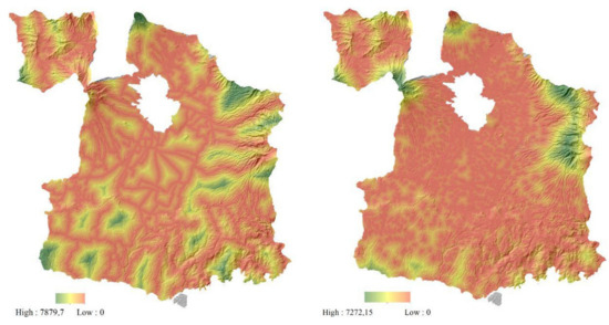
Figure A1.
Euclidean distance result for road and built-up structure as a driving factor.
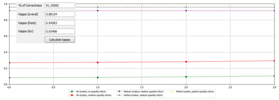
Figure A2.
The Kappa analysis result.
References
- Ziai, A. Development Discourse and Global History: From Colonialism to the Sustainable Development Goals; Taylor & Francis: New York, NY, USA, 2016. [Google Scholar]
- De Jong, E.; Vijge, M.J. From Millennium to Sustainable Development Goals: Evolving Discourses and Their Reflection in Policy Coherence for Development. Earth Syst. Gov. 2021, 7, 100087. [Google Scholar] [CrossRef]
- Davidson, J. Then and Now: Campaigns to Achieve Rice Self-Sufficiency in Indonesia. Bijdr. Tot Taal-Land-Volkenkd./J. Humanit. Soc. Sci. Southeast Asia 2018, 174, 188–215. [Google Scholar] [CrossRef]
- Pawera, L.; Khomsan, A.; Zuhud, E.A.; Hunter, D.; Ickowitz, A.; Polesny, Z. Wild Food Plants and Trends in Their Use: From Knowledge and Perceptions to Drivers of Change in West Sumatra, Indonesia. Foods 2020, 9, 1240. [Google Scholar] [CrossRef] [PubMed]
- Sarna, K.; Ismail, N.; Supriyono, H. After the Trade Dispute: Is Indonesian Food Sovereignty Threatened? Udayana J. Law Cult. 2020, 4, 171–192. [Google Scholar] [CrossRef]
- Viana, C.M.; Freire, D.; Abrantes, P.; Rocha, J.; Pereira, P. Agricultural Land Systems Importance for Supporting Food Security and Sustainable Development Goals: A Systematic Review. Sci. Total Environ. 2022, 806, 150718. [Google Scholar] [CrossRef] [PubMed]
- Helmer, E.H.; Brown, S.; Cohen, W. Mapping Montane Tropical Forest Successional Stage and Land Use with Multi-Date Landsat Imagery. Int. J. Remote Sens. 2000, 21, 2163–2183. [Google Scholar] [CrossRef]
- Hussain, M.; Chen, D.; Cheng, A.; Wei, H.; Stanley, D. Change Detection from Remotely Sensed Images: From Pixel-Based to Object-Based Approaches. ISPRS J. Photogramm. Remote Sens. 2013, 80, 91–106. [Google Scholar] [CrossRef]
- Jat, M.K.; Garg, P.K.; Khare, D. Monitoring and Modelling of Urban Sprawl Using Remote Sensing and GIS Techniques. Int. J. Appl. Earth Obs. Geoinf. 2008, 10, 26–43. [Google Scholar] [CrossRef]
- Pratomoatmojo, N. LanduseSim Algorithm: Land Use Change Modelling by Means of Cellular Automata and Geographic Information System; IOP Publishing: Bristol, UK, 2018; Volume 202, p. 012020. [Google Scholar] [CrossRef]
- Ramírez, M.T.T.; Mejía Carlos, M.; Murguía Ibarra, J.S.; Ontañon García, L.J. Partial Image Encryption Using Cellular Automata. Comput. Sist. 2019, 23, 1575–1582. [Google Scholar] [CrossRef]
- Ghalehteimouri, K.J.; Shamsoddini, A.; Mousavi, M.N.; Ros, F.B.C.; Khedmatzadeh, A. Predicting Spatial and Decadal of Land Use and Land Cover Change Using Integrated Cellular Automata Markov Chain Model Based Scenarios (2019–2049) Zarriné-Rūd River Basin in Iran. Environ. Chall. 2022, 6, 100399. [Google Scholar] [CrossRef]
- Wolfram, S. Statistical Mechanics of Cellular Automata. Rev. Mod. Phys. 1983, 55, 601–644. [Google Scholar] [CrossRef]
- Singh, A.K. Modelling Land Use Land Cover Changes Using Cellular Automata in a Geo-Spatial Environment; ITC: Kolkata, India, 2003. [Google Scholar]
- Susilo, B. Pemodelan Spasial Probabilistik Integrasi Markov Chain Dan Cellular Automata Untuk Kajian Perubahan Penggunaan Lahan Skala Regional Di Provinsi Daerah Istimewa Yogyakarta. J. Geogr. Gea 2011, 11. [Google Scholar] [CrossRef]
- Baig, M.F.; Mustafa, M.R.U.; Baig, I.; Takaijudin, H.B.; Zeshan, M.T. Assessment of Land Use Land Cover Changes and Future Predictions Using CA-ANN Simulation for Selangor, Malaysia. Water 2022, 14, 402. [Google Scholar] [CrossRef]
- Girma, R.; Fürst, C.; Moges, A. Land Use Land cover Change Modeling by Integrating Artificial Neural Network with Cellular Automata-Markov Chain Model in Gidabo River Basin, Main Ethiopian Rift. Environ. Chall. 2022, 6, 100419. [Google Scholar] [CrossRef]
- Munthali, M.G.; Davis, N.; Adeola, A.M.; Botai, J.O.; Kamwi, J.M.; Chisale, H.L.W.; Orimoogunje, O.O.I. Local Perception of Drivers of Land-Use and Land-Cover Change Dynamics across Dedza District, Central Malawi Region. Sustainability 2019, 11, 832. [Google Scholar] [CrossRef]
- Damayanti, F.; Rahma, P.D. Identifikasi Kawasan Slum Area Di Kota Malang. Rekayasa J. Tek. Sipil 2018, 3, 13–20. [Google Scholar]
- Central Bureau of Statistics in Malang Regency. Rice Field Area by District and Type of Irrigation in Malang Regency (Hectare). Available online: https://malangkab.bps.go.id/statictable/2020/06/05/831/luas-lahan-sawah-menurut-kecamatan-dan-jenis-pengairan-di-kabupaten-malang-hektar-2016-2019.html (accessed on 22 May 2022).
- Varon, D.J.; Jervis, D.; McKeever, J.; Spence, I.; Gains, D.; Jacob, D.J. High-Frequency Monitoring of Anomalous Methane Point Sources with Multispectral Sentinel-2 Satellite Observations. Atmos. Meas. Tech. 2021, 14, 2771–2785. [Google Scholar] [CrossRef]
- Ramadhani, F.; Pullanagari, R.; Kereszturi, G.; Procter, J. Automatic Mapping of Rice Growth Stages Using the Integration of SENTINEL-2, MOD13Q1, and SENTINEL-1. Remote Sens. 2020, 12, 3613. [Google Scholar] [CrossRef]
- Putra, A.N.; Nita, I. Reliability of Using High-Resolution Aerial Photography (Red, Green and Blue Bands) for Detecting Available Soil Water in Agricultural Land. J. Degrad. Min. Lands Manag. 2020, 7, 2221. [Google Scholar] [CrossRef][Green Version]
- Wang, Q.; Shi, W.; Li, Z.; Atkinson, P.M. Fusion of Sentinel-2 Images. Remote Sens. Environ. 2016, 187, 241–252. [Google Scholar] [CrossRef]
- Chavez, J.; Pat, S. Image-Based Atmospheric Corrections—Revisited and Improved. Photogramm. Eng. Remote Sens. 1996, 62, 1025–1036. [Google Scholar]
- Ma, Z.; Liu, Z.; Zhao, Y.; Zhang, L.; Liu, D.; Ren, T.; Zhang, X.; Li, S. An Unsupervised Crop Classification Method Based on Principal Components Isometric Binning. ISPRS Int. J. Geo-Inf. 2020, 9, 648. [Google Scholar] [CrossRef]
- Wang, S.W.; Gebru, B.M.; Lamchin, M.; Kayastha, R.B.; Lee, W.-K. Land Use and Land cover Change Detection and Prediction in the Kathmandu District of Nepal Using Remote Sensing and GIS. Sustainability 2020, 12, 3925. [Google Scholar] [CrossRef]
- Cahyono, B.E.; Febriawan, E.B.; Nugroho, A.T. Analisis Tutupan Lahan Menggunakan Metode Klasifikasi Tidak Terbimbing Citra Landsat di Sawahlunto, Sumatera Barat (Land cover Analysis Using Unsupervised Classification Method of Landsat Imagery in Sawahlunto, West Sumatera). J. Tektonan 2019, 13, 8. [Google Scholar] [CrossRef]
- Nita, I.; Putra, A.N.; Fibrianingtyas, A. Analysis of Drought Hazards in Agricultural Land in Pacitan Regency, Indonesia. SAINS TANAH-J. Soil Sci. Agroclimatol. 2020, 17, 7–15. [Google Scholar] [CrossRef]
- Hakim, A.; Baja, S.; Rampisela, D.; Arif, S. Spatial Dynamic Prediction of Landuse/Landcover Change (Case Study: Tamalanrea Sub-District, Makassar City); IOP Publishing: Bristol, UK, 2019; Volume 280, p. 012023. [Google Scholar] [CrossRef]
- Surya, B.; Ahmad, D.N.A.; Sakti, H.H.; Sahban, H. Land Use Change, Spatial Interaction, and Sustainable Development in the Metropolitan Urban Areas, South Sulawesi Province, Indonesia. Land 2020, 9, 95. [Google Scholar] [CrossRef]
- Li, K.; Feng, M.; Biswas, A.; Su, H.; Niu, Y.; Cao, J. Driving Factors and Future Prediction of Land Use and cover Change Based on Satellite Remote Sensing Data by the LCM Model: A Case Study from Gansu Province, China. Sensors 2020, 20, 2757. [Google Scholar] [CrossRef]
- Ikegwuoha, D.C.; Weepener, H.L.; Dinka, M.O. Future Land Use Change Simulations for the Lepelle River Basin Using Cellular Automata Markov Model with Land Change Modeller-Generated Transition Areas. F1000Research 2021, 10, 796. [Google Scholar] [CrossRef]
- Fitriyani, F.; Fitriyani, R.; Rosmawanti, N. Penerapan Algoritma Euclidean Distance Untuk Pemilihan Paket Internet Berdasarkan Wilayah. Progresif: J. Ilm. Komput. 2017, 13, 12. [Google Scholar]
- Ibarra-Bonilla, J.S.; Villarreal-Guerrero, F.; Prieto-Amparán, J.A.; Santellano-Estrada, E.; Pinedo-Alvarez, A. Characterizing the Impact of Land-Use/Land-Cover Changes on a Temperate Forest Using the Markov Model. Egypt. J. Remote Sens. Space Sci. 2021, 24, 1013–1022. [Google Scholar] [CrossRef]
- Gharbia, S.S.; Alfatah, S.A.; Gill, L.; Johnston, P.; Pilla, F. Land Use Scenarios and Projections Simulation Using an Integrated GIS Cellular Automata Algorithms. Modeling Earth Syst. Environ. 2016, 2, 151. [Google Scholar] [CrossRef]
- Congalton, R.G.; Green, K. Assessing the Accuracy of Remotely Sensed Data: Principles and Practices; CRC Press: Boca Raton, FL, USA, 2019. [Google Scholar]
- Al-Rubkhi, A.; Talal, A.; Mohammed, A. Land Use Change Analysis and Modeling Using Open Source (QGis)-Case Study: Boasher Willayat. Ph.D. Thesis, College of Arts and Social Science, Department of Geography, Sultan Qaboos University, Muscat, Oman, 2017. [Google Scholar]
- Buğday, E.; Buğday, S.E. Modeling and Simulating Land Use/Cover Change Using Artificial Neural Network from Remotely Sensing Data. Cerne 2019, 25, 246–254. [Google Scholar] [CrossRef]
- Cao, C.; Dragićević, S.; Li, S. Short-Term Forecasting of Land Use Change Using Recurrent Neural Network Models. Sustainability 2019, 11, 5376. [Google Scholar] [CrossRef]
- ESRI. Perform Analysis—ArcGIS Online Help|Documentation. Available online: https://doc.arcgis.com/en/arcgis-online/analyze/perform-analysis.htm (accessed on 22 May 2022).
- Leta, M.K.; Demissie, T.A.; Tränckner, J. Modeling and Prediction of Land Use Land cover Change Dynamics Based on Land Change Modeler (Lcm) in Nashe Watershed, Upper Blue Nile Basin, Ethiopia. Sustainability 2021, 13, 3740. [Google Scholar] [CrossRef]
- Roberts, D.; Mattoo, A. Agriculture Sustainable Agriculture-Enhancing Environmental Benefits, Food Nutritional Quality and Building Crop Resilience to Abiotic and Biotic Stresses. Agriculture 2018, 8, 8. [Google Scholar] [CrossRef]
- Motschenbacher, J.; Brye, K.; Anders, M.; Gbur, E.; Slaton, N.; Evans-White, M. Daily Soil Surface CO2 Flux during Non-Flooded Periods in Flood-Irrigated Rice Rotations. Agron. Sustain. Dev. 2014, 35, 771–782. [Google Scholar] [CrossRef]
- Magagula, B.; Tsvakirai, C.Z. Youth Perceptions of Agriculture: Influence of Cognitive Processes on Participation in Agripreneurship. Dev. Pract. 2020, 30, 234–243. [Google Scholar] [CrossRef]
- United Nations. The Intimate Relationship between Food Security and Land. Available online: https://www.un.org/en/academic-impact/intimate-relationship-between-food-security-and-land (accessed on 22 May 2022).
- USAID. Nutrition, Food Security and Family Planning: Technical Guidance Brief. Available online: https://www.usaid.gov/global-health/health-areas/nutrition/technical-areas/nutrition-food-security-and-family-planning (accessed on 22 May 2022).
- Partoyo; Shrestha, R.P. Chapter 5—Modeling Effect of Conservation and Livelihood Policies on Community Land Use and Management in Yogyakarta. In Redefining Diversity & Dynamics of Natural Resources Management in Asia; Shivakoti, G.P., Pradhan, U., Helmi, Eds.; Elsevier: Amsterdam, The Netherlands, 2017; Volume 1, pp. 67–90. [Google Scholar] [CrossRef]
- Khumairoh, U.; Lantinga, E.A.; Schulte, R.P.; Suprayogo, D.; Groot, J.C. Complex Rice Systems to Improve Rice Yield and Yield Stability in the Face of Variable Weather Conditions. Sci. Rep. 2018, 8, 14746. [Google Scholar] [CrossRef]
Publisher’s Note: MDPI stays neutral with regard to jurisdictional claims in published maps and institutional affiliations. |
© 2022 by the authors. Licensee MDPI, Basel, Switzerland. This article is an open access article distributed under the terms and conditions of the Creative Commons Attribution (CC BY) license (https://creativecommons.org/licenses/by/4.0/).