1. Introduction
A historic district has experienced a rich history of social life and contains a wealth of buildings and spaces that symbolize different historical periods [
1]. It not only reflects the image of a city but is also an important part of its historical heritage [
2]. It has a profound historical and cultural background and displays features of life’s patterns [
3]. After the fast-paced spread of the city, the development mode began to change from “incremental expansion” to “stock renewal” [
4,
5]. Urban sprawl as a global phenomenon began in most European cities in the 19th century and immediately attracted planners’ attention to the historical spatial environment [
6]. However, in the process of accelerating urban construction, with the shortening of the cycle of urban development, historical blocks generally show the phenomenon of serious commercialization and serious homogeneity of block renovation. At the same time, because the urban historical landscape and traditional cultural activity space are being compressed by the rapidly developing modern economy, they gradually decline or disappear in the process of globalization, commercialization and urbanization [
7]. Therefore, the renewal of historic districts is extremely urgent. Reasonable and effective landscape protection and reasonable and effective visual perception of the interaction between people and environment [
8] are beneficial to promoting the development of the modernization of city [
9], can upgrade the ownership value for urban people, and enhance the cultural identity of the city. Therefore, urban design should pay attention to appearance and function, sites for economic development, landscape protection and cultural heritage simultaneously [
10] in order to realize the sustainable development of historical blocks.
This paper firstly reviews the progress of research on historical and cultural blocks, introduces the importance of landscape visual evaluation for the development of historical blocks, introduces the research object and related research methods, and then analyzes the data of nine historical streets and alleys through questionnaires to discuss the relationship between urban development and historical and cultural heritage. From the perspective of practical experiences, exploring the characteristics of and influencing factors in the relationship between the public and the cultural landscape of historical blocks will help future construction and research and provide an important basis for urban managers to evaluate the advantages and disadvantages of cultural landscapes of historical blocks. Finally, the paper discusses the main results of the research and puts forward some suggestions for reference.
2. Literature Review
2.1. Protection Policy
The preservation of urban historic districts is a process involving cultural, social and economic issues and is influenced by political decisions at the local and national levels [
11]. Since 1970, many countries have begun to study the protection and development of urban historic blocks, extending the scope of protection from single historical and traditional buildings to collective historical and traditional buildings. Additionally, the urban landscape, the environment of historical and traditional buildings and the economic factors favorable to the protection of historical and traditional buildings are taken as the key protection objects [
12].
From the perspective of historical and cultural block protection policies, the early policies paid more attention to the historical characteristics of historical and traditional buildings as heritage. With the improvement in awareness and the development of the economy, it is necessary to consider the change in land type, the planning of transportation systems, the size of population and other factors during the urban development of historical districts in the protection plan. In addition, historical and cultural factors should also be considered. Urban planning should move gradually from static protection to dynamic protection, from the protection of a single building or group of buildings to the protection of the physical and non-physical factors of the entire space, and put forward relevant policies to deal with the possible impact of social change on historical blocks (shown in
Table 1).
The theoretical research on the protection of historic blocks has a certain scale in the world and has formed a relatively complete theoretical system. Many countries attach great importance to the overall protection of historic districts, which leads to the participation of stakeholders in the city administration in the urban planning and conservation process [
13]. France was the first country to establish protection laws for historic districts. In 1913, it promulgated the Law of Historical Monuments, which has become an important theoretical basis and legal benchmark for the enactment of laws and policies related to historical heritage in France. In 1930, France promulgated the Law of Landscape Protection, which included the content of landscape protection planning for historic buildings and their surroundings. The Malraux Law, promulgated in 1962, incorporated the protection of historic districts into urban planning and strictly stipulated specific requirements and operational standards for the maintenance and renovation of protected areas of different levels. The Urban Planning Act of 1973 stipulates that a historic district should be protected as a whole. In the 1970s, Italy took the lead in putting forward the concept of “holistic protection” of historical and cultural heritage, advocating that not only the buildings of historical sites should be protected but also the lifestyles and cultural traditions connected with them [
14]. Rogers believes that there is a long-term dialectical relationship between the protection and development of historic blocks, which should be properly developed and controlled to properly handle the relationship. In 1944, the UK promulgated the Urban Planning Act, which provided relevant explanations for the collation, statistics and investigation of various buildings in the UK’s historic districts. In 1967, the was formally promulgated, which legally restrained the acts of arbitrary destruction and demolition, and the historical districts were clearly protected by laws and policies.
Studies on historical and cultural blocks in China mainly focus on the period after 2001. With the development of social economy and the improvement in the overall level of consciousness, the research and conservation practices for historical blocks in China have made great progress, and the research work has been gradually deepened. Firstly, the research content develops from static protection to dynamic renewal. Secondly, the research field is constantly broadened. Around the 1990s, many Chinese experts made in-depth explorations of the protection and development of historical and cultural blocks. Wu Liangyong advocates that the process of reconstruction of the old city should not only follow the inherent law of urban development, protecting the integrity and traditional characteristics of the old city pattern, but also guide the new organic order. Wang Jinghui proposed methods for the protection of famous historical and cultural cities in China, which provided important theoretical guidance for the protection of famous historical and cultural cities and historical and cultural blocks. Since then, more and more scholars have devoted themselves to research on the development of historical and cultural blocks, carrying out multi-dimensional and multi-angle exploration.
2.2. Public Participation
From the perspective of public participation, the protection of historical and cultural blocks, as a public affair, requires the joint participation of multiple subjects and plays a crucial role in promoting urban economic development, protecting regional culture and enhancing public participation. In 1853, the Women’s Association for the Preservation of Mount Vernon House succeeded in preserving George Washington’s residence, an event that made a significant impact in the United States and led to the emergence of public participation in historic district preservation in the United States. Since then, in the 1970s, western developed countries began to carry out research on public participation in the protection of historical and cultural blocks. In 1962, Davidoff proposed the theory of advocacy planning, pointing out that different planners representing stakeholders should discuss and make decisions together, and public opinions should be properly absorbed to coordinate the distribution of social interests [
15]; thus, the ideological theory and practice basis of public participation was preliminarily established. In 1987, the Charter for the Preservation of Historic Towns and Districts, adopted by the International Council on Monuments and Sites, emphasized public participation as an important part of the preservation of historic districts. In the 1980s, Innes put forward a liaison planning theory that advocates making full use of community planners’ information communication, coordination and management capabilities, attaches importance to and advocates public participation and encourages community residents and other members of the public to actively participate in the protection and development of historic blocks [
16].
2.3. Tourism Development
Tourists are the main body of the urban foreign population, and the cultural perception of tourists is the main component of urban cultural perception [
17]. From the perspective of tourism development, Paul M Fotsch believes that the phenomenon of global competition in the development of tourism will have an impact on historic blocks [
18]. Sobotka L. A. studied the evaluation system of block tourism development [
19]. The restoration of historical blocks, starting from tourism development, can diversify the functions of historical blocks and even change the original pattern [
20]. Kevin Meethan believes that through the landscape, architecture, characteristic activities and souvenir sales of a historic district, tourists can perceive the cultural value of the historic district, drive consumption through tourism and promote the economic development of the historic district [
21]. Starting from the perspective and ideas of world tourism research, Philip Kotler studied tourism marketing theory in depth and applied it to the development of historical districts [
22]. Isabelle Frochot studied from the perspective of improving the quality of tourism service management and constructed a heritage tourism development model for historic blocks [
23], providing suggestions and theoretical support for promoting the effective protection of historical and cultural blocks and the sustainable development of tourism.
Since then, the protection of and research on historical and cultural blocks have attracted the attention of many disciplines, such as geography, cultural heritage, tourism, urban planning and architecture [
24,
25], gradually extending to other professional fields. Using GIS technology to study historical blocks [
26] or questionnaire survey and SWOT analysis of historical blocks can achieve the regeneration of the space within the historic blocks, forming a systematic and complete process, to achieve the expected development effect [
27]. Based on the study of Feizabad Historical and Cultural Block in Kermanshah, Ghorbani et al. used content analysis, interpretive historical analysis and spatial syntactic analysis to combine quantitative and qualitative techniques to formulate strategies suitable for the study area [
28]. Atik, M analyzed 35 landscape features as variables with aesthetic and cultural value, sensibility and natural characteristics in Side District of the Mediterranean region in Turkey, so as to realize the interaction between environment and landscape [
29]. Landscape, as a permanent foundation, can create and maintain the relationship with space [
30] and promote the sustainable development of historic blocks by integrating landscape resources within the historic blocks.
3. Landscape Visual Evaluation
In 2000, the European Landscape Convention (ELC) defined a landscape as a perceived area whose characteristics are the result of the action and interaction of natural and/or human factors [
31]. As an important research method, the visual value of landscape visual evaluation has become an important part of the comprehensive protection of cultural landscapes. Cosgrowe also emphasized the importance of visual perception in his article [
32]. On the one hand, human perception of landscapes mainly comes from the visual system. Visual perception has absolute advantages in perception ability, degree of comprehension and use of time and space over various other attributes. On the other hand, people’s evaluation of visual landscape is also affected by psychology and emotion, and there are differences in the evaluation of material form beauty under different psychological and emotional states. In addition, landscape visual evaluation should be based on certain evaluation objectives and needs, and the value orientation of the evaluator acts as the benchmark to manage and evaluate visual landscape resources.
With the establishment of relevant laws, the research on landscape visual resources has gradually become scientific and systematic. By the early 1980s, there appeared four recognized schools in landscape evaluation: the expert school, the psychophysical school, the cognitive school, and the empirical school (shown in
Table 2).
The landscape elements of historical and cultural blocks are historical products of certain social changes and evolution, with unique material substance and spiritual connotation, mainly composed of the material substance and the spirit of the place formed by it. As far as the constitutive attributes of matter are concerned, on the one hand, there are dynamic natural landscape elements with vitality, which usually have little human intervention, and they change dynamically over time. On the other hand, there are material entities created entirely through artificial construction, which are the result of the interaction between human activities and natural landscapes [
35]. As a kind of invisible landscape element, the spirit of place formed in a block will affect people’s aesthetic feelings for the visual elements in the block, which is also an important part of the landscape of historical and cultural blocks.
Based on the protection value orientation, this paper conducts in-depth landscape evaluation research on the streets and alleys in historical and cultural street areas. Nine historical and cultural streets were selected from four historical and cultural blocks in Quanzhou as the research object, and the landscape visual evaluation was carried out through semantic analysis and factor analysis, making statistics of the data after the questionnaire survey and drawing a line chart according to the comprehensive score to analyze the overall situation. Secondly, the SD method was used with quantitative data determined by SPSS software for factor and factor analysis and comprehensive sequencing, the purpose being to concretize the form value of historical and cultural blocks and then establish a quantifiable form value evaluation system for historical and cultural blocks through the establishment of form value elements. It provides scientific reference for the renewal and development of historical and cultural blocks in the future.
4. Materials and Methods
4.1. Research Objects
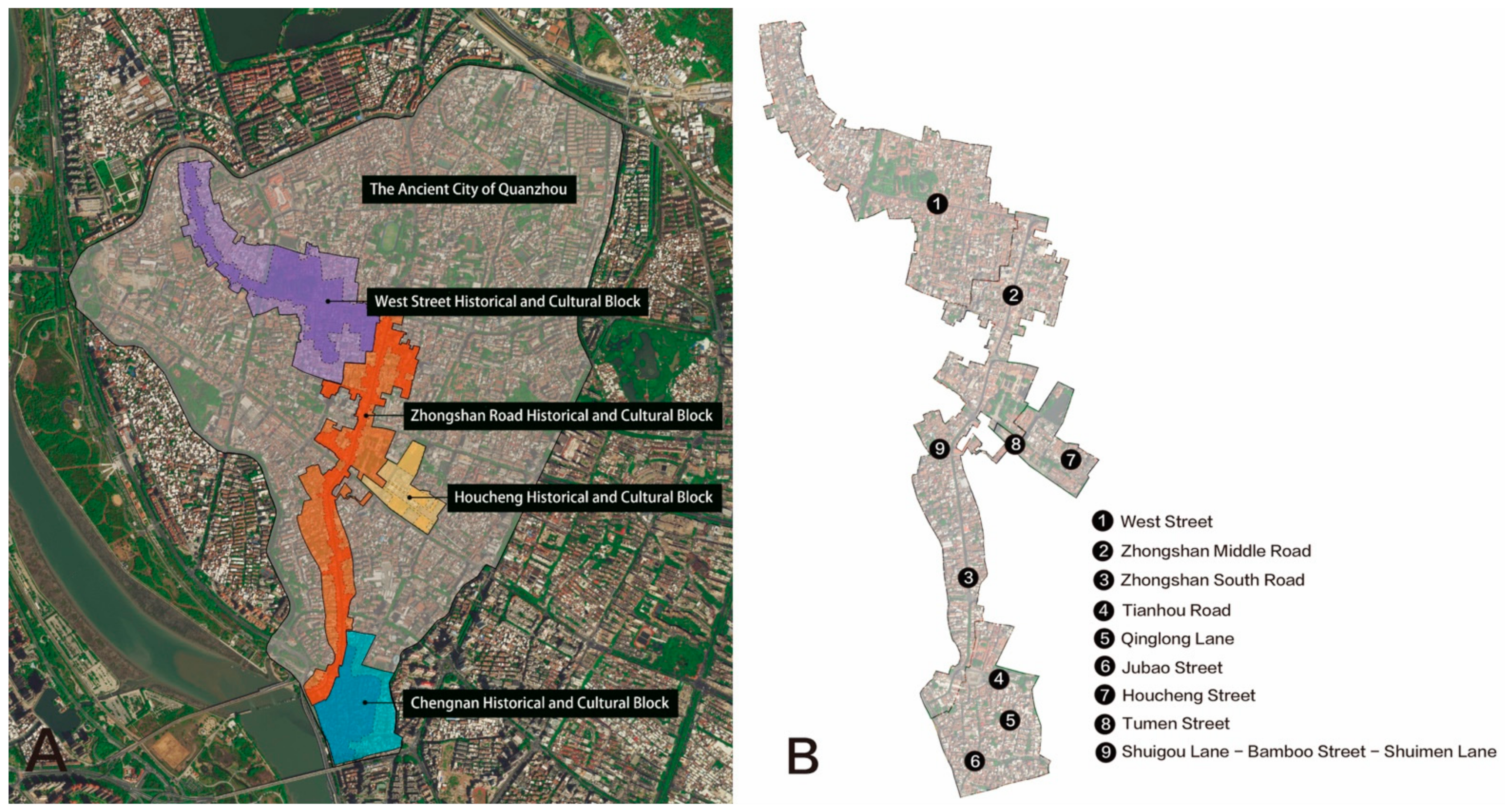
As one of the first state-level historical and cultural cities announced by the State Council, Quanzhou is the first “Cultural Capital of East Asia” and the starting point of China’s ancient “Maritime Silk Road”. The ancient city was built in Fengzhou and formed a market pattern in the Tang Dynasty. It covers an area of 6.41 square kilometers and is rich in cultural relics and historic sites. According to the protection plan of Quanzhou Historical and cultural city in 2017, there are 4 confirmed historical and cultural blocks in the ancient city area, which are West Street Historical and Cultural Block, Zhongshan Road Historical and Cultural Block, Chengnan Historical and Cultural Block and Houcheng Historical and Cultural Block. The total area of the protected area is about 127.8 hectares, of which the core protected area is 63.2 hectares (
Figure 1).
As important parts of the block, historical streets and alleyways reflect the urban planning concepts and construction level in a specific period, becoming important clues for in-depth understanding of the context of historical blocks, with sustainable and organic growth [
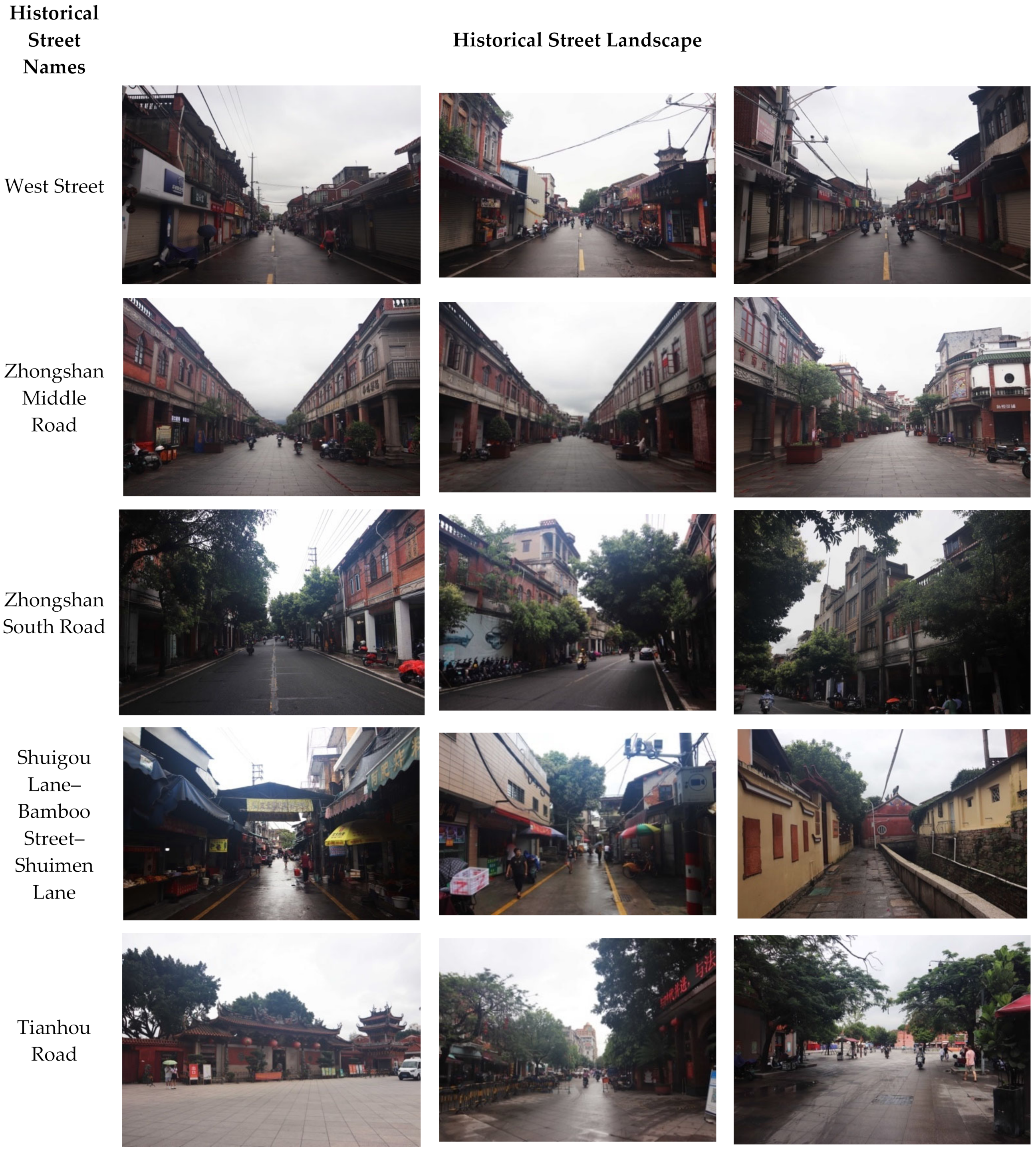
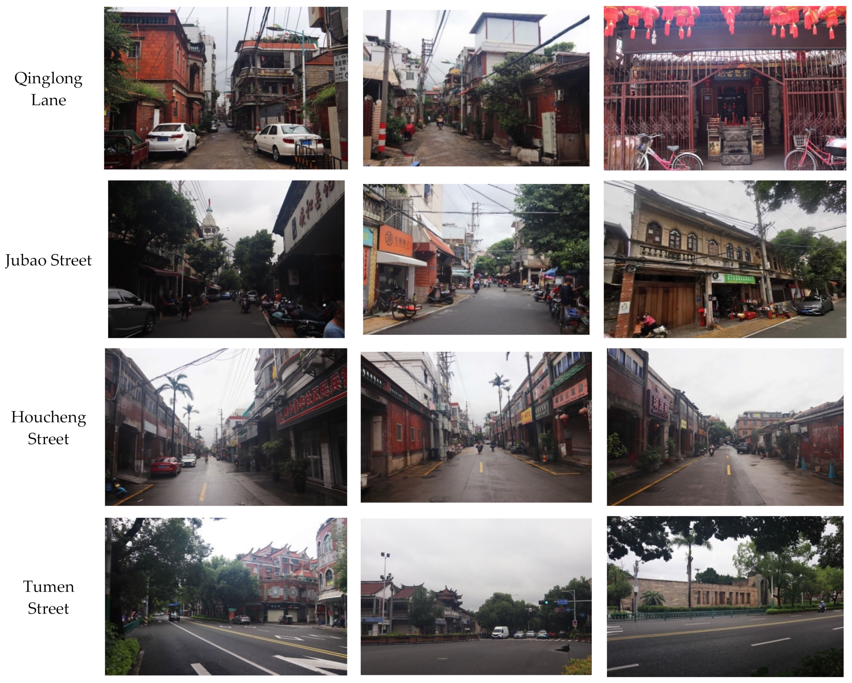
36]. In this paper, the selected research object follows the scientific and cultural principle, in that, from 4 of the historical and cultural blocks, nine historical streets of several lanes were selected as the landscape visual evaluation sample, which are Xijie Street, Zhongshan Middle Road, Zhongshan South Road, Houcheng Street, Tu Men Street, Tianhou Road, Qinglong Lane, Jubao Street and the streets Shuimen Lane, Zhujie and Shuigou Lane collectively (see
Appendix A Figure A1), all of which meet the following four conditions: (1) large historical space, (2) a concentration of historic buildings, (3) preserved rich cultural relics, (4) more completely and truly reflective of the traditional pattern and historical style. Specific street information is as follows (See
Table 3):
- (1)
West Street: As the earliest developed street and area in Quanzhou, it is about 450 m long and 10 m wide. It not only is the most intact ancient street in Quanzhou city, but also contains a large number of buildings with original historical appearance, symbolizing the prosperity of Quanzhou. In addition to Kaiyuan Temple, it also includes Hucuo Pond, Octagonal Tower, Yicheng Temple, Fengsheng Palace, Miaoyin Tzu Chi Palace, Zhu Jian Shrine, Christian Quanxi Hall and other well-preserved traditional buildings, which contain rich historical and cultural precipitation.
- (2)
Zhongshan Middle Road: As an important part of Quanzhou Zhongshan road historical block, it is a famous city street, about 890 m long and 10 m wide, with many buildings featuring decorative architecture, including Confucius Temple, Jin Yuan, ZhuangJi Chang Temple, Wen Zhuangcai Shrine, Second Place, Huaqiao Tzu Chi Palace, Li Hongcheng’s former residence, Nine Saints Church, Clock Tower, Christian Quannan Church and Chen Guangchun’s former residence. These buildings form a unified and harmonious historical style within the block.
- (3)
Zhongshan South Road: It is an important section under the protection of “Three sections and one line” of the ancient city. It is about 1700 m long and 10 m wide. In addition to the time-honored Twin buildings, there are also the Huaqiao Tzu Chi Palace, Li Hongcheng’s former residence, Nine Saints Church, etc., which have important historical and cultural values and embody unique emotional colors.
- (4)
Shuigou Lane–Bamboo Street–Shuimen Lane: As a part of Zhongshan Road historical and cultural block, Shuigou Lane is adjacent to Bamboo Street, and Shuimen Lane is connected to Bamboo Street in the west. The three lanes interact with each other. Sanyi Temple, Quanjun Tongjin Li, Chen’s Dashan Hong, Quanzhou Bosi Site, Tripod Liao, Donghui Laopan Palace, Tongjin Scenic spot and South Xunmen gate site all do not reflect the unique historical and cultural features of Quanzhou.
- (5)
Tianhou Road: It used to be the place where people went to worship and pray for good fortune before merchant ships went to sea and when merchant ships arrived at the port. It was about 800 m long and 10 m wide. It is also famous because there is a Tianhou Palace built in the Song Dynasty with great popularity. In addition, historic buildings such as the Dejimen ruins and Quanjun Emperor’s Palace, which are located directly opposite the Temple, make Tianhou Road of great historical value.
- (6)
Qinglong Lane: As one of the well-preserved traditional residential streets in Quanzhou city, it is 235 m long and 5.5 m wide. The buildings with regional cultural characteristics, such as Qinglong Ancient Land, Li Miaosen’s former residence, Huang Xuezhen’s residence, Quanjun Lingying Palace and Linlian Pinghai Oyster Shell House, are the concrete witnesses to the prosperity of Quanzhou’s history and culture.
- (7)
Jubao Street: As a main road in the southern historic district of the city, it is 445 m long and 8–10 m wide. Many ancient buildings stand along the street, including LaiYuan Yi site, Christian Jubao Hall, Yinquan, Quanjun Houshan Palace and Huang Houzhong’s former residence, which are of great value in traditional culture, architecture and folklore.
- (8)
Houcheng Street: It is about 700 m long and about 6 m wide, with ancient dwellings kept relatively complete and unique architectural style, in addition to being thick with the characteristics of Master Houcheng, Shuangru Springs, YiChun ancient land, Fahua An and Nan Yin Hall. There are also the traditional folk arts and crafts tourism commodity specialized markets, such as Gubaozhai and Chongyutang, which have formed a development trend integrating cultural landscape, tourism service and commercial ecology.
- (9)
Tumen Street: Located in the central area of Quanzhou city, stretching from Wenling Road in the east to Zhongshan Road in the west, it is about 1005 m long and 22 m wide. It is a prosperous community in commerce, tourism, culture, etc. Along the street, there are Qingjing Temple, Tonghuaiguan Yue Temple, Dongxing Pavilion, Confucius Confucian Temple, East and West viewing platform, Zulu Su, Family Da Cuo, Chess Garden, Shijia Temple, JiuFeng Legacy, East Lu Scenic Water Tail Palace, Ceylonese former residences, Tu Men Water Pass and other ancient cultural relics. To a certain extent, the architectural style of Tu Men Street reflects the prosperity of Quanzhou in the Song and Yuan dynasties, forming a landscape character that not only has the style of Quanzhou Minnan ancient architecture but also organically combines with modern architecture.
4.2. SD (Semantic Analysis Method)
Semantic analytic method (SD) is a research method of the psychological school founded by Osgoode in 1957 [
37]. The research process is to use relevant words to classify grades, rating several concepts on a set of bipolar adjective scales by a sample of subjects [
38], so as to assess the psychology of the respondents. Then, the scale of grades and research objects that have been set are analyzed, and the data for further calculation are quantified. It is most applied in architecture, landscape, planning and other related fields. The research shows that semantic analysis has high reliability. Semantic analysis can measure the attitude of respondents to research objects in different dimensions and implement standardization of procedures and scoring procedures, which can improve the degree of test consistency.
4.3. FA (Factor Analysis)
Hotelling first proposed factory analysis (FA) in 1933, which is also known as the method of major component sharing. To put it simply, factor analysis measures the importance of the relationship between characteristics by studying the current concise and refined summary of the relationship between the characteristics, deriving relationship between the variables of the analysis, and reducing the final attribute to a “factor”. Factor analysis is a multivariate statistical analysis that extracts a large number of complex index data into a number of comprehensive indexes with generality by using the low-dimensional idea [
39]. In practical application, the importance index of different factors can be obtained through factor score, and the problem to be solved first can be decided according to the importance of these indicators.
5. Visual Evaluation of Historical and Cultural Block Landscape Based on SD Method
5.1. The Choice of Adjective Pair and Evaluation Scale
After field investigation and visits to the five sample sites in the early stage, combined with the sorting of the basic data of the above five historical and cultural blocks, and after proposing the object content of the visual evaluation of historical streets and alleyways, referring to the evaluation criteria in the Evaluation Index System of Famous Chinese Historical and Cultural Towns (Villages), twenty-three pairs of adjectives were selected for visual evaluation of street and lane spatial landscape in historical and cultural blocks (
Table 4).
In this study, Delphi method was adopted to collect data related to participants’ personal experience and the knowledge of each invited expert through certain means, so as to form collective wisdom and facilitate appropriate analysis and evaluation of key factors. Delphi emphasizes structured, anonymous communication between individuals with expertise in a field, with the goal of reaching consensus on policy, practice, or organizational decisions. In this survey, six experts and professors engaged in research on historical and cultural cities, historical and cultural blocks, architectural landscape and other aspects were invited to score the above indicators and provide expert opinions. Likert five-point scale was used to measure the evaluation items: strongly agree, agree, neutral, disagree, strongly disagree. The scores were 5, 4, 3, 2 and 1. Taking the feedback of experts and professors into consideration, the following modifications were made to the preset SD factor: “(08) Degree of environmental seclusion”, “(14) Degree of unity of architectural style” and “(19) degree of scientific management” were eliminated; “(10) Building complexity” was changed to “building modeling complexity”; and three pairs of adjectives were added, namely “brightness”, “integrity of building style” and “recognition of local characteristics”.
After modification, the 23 adjectives finally obtained were sorted according to the four levels of evaluation object content proposed above (overall perception, architectural style, vegetation greening and cultural elements), and compiled into the Questionnaire for Landscape Visual Evaluation of Historical and Cultural Blocks of Quanzhou Ancient City (
Table 5).
After the above adjectives are determined, the evaluation scale needs to be selected. After reviewing the literature related to SD evaluation, it was found that 5–7 levels are generally selected, preferably not fewer than 5 levels. If the levels are fewer than 5, the evaluation scale will be too thin, be difficult to summarize, and easily cause inaccurate evaluation results [
40]. Therefore, after comprehensive consideration, the designated evaluation factor was set as 23 pairs of positive and antisense adjectives. The evaluation was divided into five grades, that is, very, slightly, average, slightly and very. A scoring scale of five points was adopted, with 0 as the central axis, and the score values were set as +2, +1, 0, −1 and −2, successively (
Table 6).
5.2. Selection of Subjects and Distribution of Questionnaires
The number of subjects is proportional to the accuracy of the data results. An SD survey usually takes 20–50 as the number of subjects. In the SD questionnaire, different age, educational level and familiarity with the environment all affect visual evaluation, so it is necessary to investigate the gender, age, culture and origin of the subject group. Due to the high unity and consistency of aesthetic attitudes among different groups, the number of subjects is large, and the aesthetic differences between different groups may be weakened.
The semantic differential technique uses a dimensional approach to extract the connotative dimensions of simple stimuli to form complex concepts [
41]. In order to improve the accuracy and reliability of the research results, SD questionnaires were distributed by way of field evaluation. During the period from 24 November 2021 to 19 December 2021, questionnaires were distributed in five selected historical and cultural blocks, of which 30 were distributed in each block, and subjects were randomly selected to fill in the questionnaire. Because different weather and time points may affect the mood of subjects, a similar weather situation was chosen in each of the historical streets during the different time points and holidays to distribute SD questionnaire for many times, in a combination of factors such as weather and time, on the basis of minimizing the disturbance of the study by other factors (
Table 7).
The SD questionnaire was sent to the subjects. The purpose and filling method of the survey were first introduced, and the definitions of relevant terms were explained to the subjects when necessary. As the selection of subjects covered a large range, there were uneven situations in terms of age and education level. In the process of filling in the questionnaire, the relevant terms were briefly explained to the group of subjects to achieve more accurate data. After sorting out the statistical questionnaire data, the basic information of the subject group is listed as follows:
Among the 273 subjects, 130 are female, accounting for 48% of the total number of subjects, and 143 are male, accounting for 52% of the total number of subjects. The proportion of male and female subjects is relatively balanced, and the proportion of male subjects is slightly higher than that of female subjects. In terms of age, there are 24 people under the age of 18, accounting for 9% of the total population, 191 people between 19 and 35, accounting for 70% of the total population, 48 people between 36 and 65, accounting for 18% of the total population, and 10 people over the age of 66, accounting for 4% of the total population. According to the age distribution, the largest proportion is that of subjects from 19–35 years old, mainly young and strong groups. People who are 36–65 years old account for 18%, and people under 18 years old and over 66 years old account for a relatively small proportion. In terms of level of education, the primary school level has 20 people, accounting for about 7% overall population, the junior middle school level has 28 people, accounting for about 10%, the high school level has 32 people, accounting for 12% of the total number, the college or university cultural level has 66 people, accounting for about 24% of the total, and the bachelor degree or above level has 121 people. The distribution of educational level of the subjects is balanced, with people with junior college degree or bachelor’s degree or above accounting for 71%, indicating that the overall educational level of the subjects is high. In terms of frequency of visits, 92 people visited the site twice or less, accounting for 34% of the total number of people, 48 people visited the site 3–5 times, accounting for 18% of the total number of people, and 133 people visited the site more than 5 times, accounting for 49% of the total number of people. It can be seen that most of the subjects were familiar with the site and had a high degree of familiarity. In terms of origin distribution, there are 116 local or permanent residents, accounting for 42% of the total population, 64 from other urban areas of Fujian, accounting for 23% of the total population, and 94 from other provinces and regions, accounting for 34% of the total population. The use of historic streets by local residents and permanent residents is relatively high.
5.3. Comprehensive Evaluation Average Value Statistics and Analysis
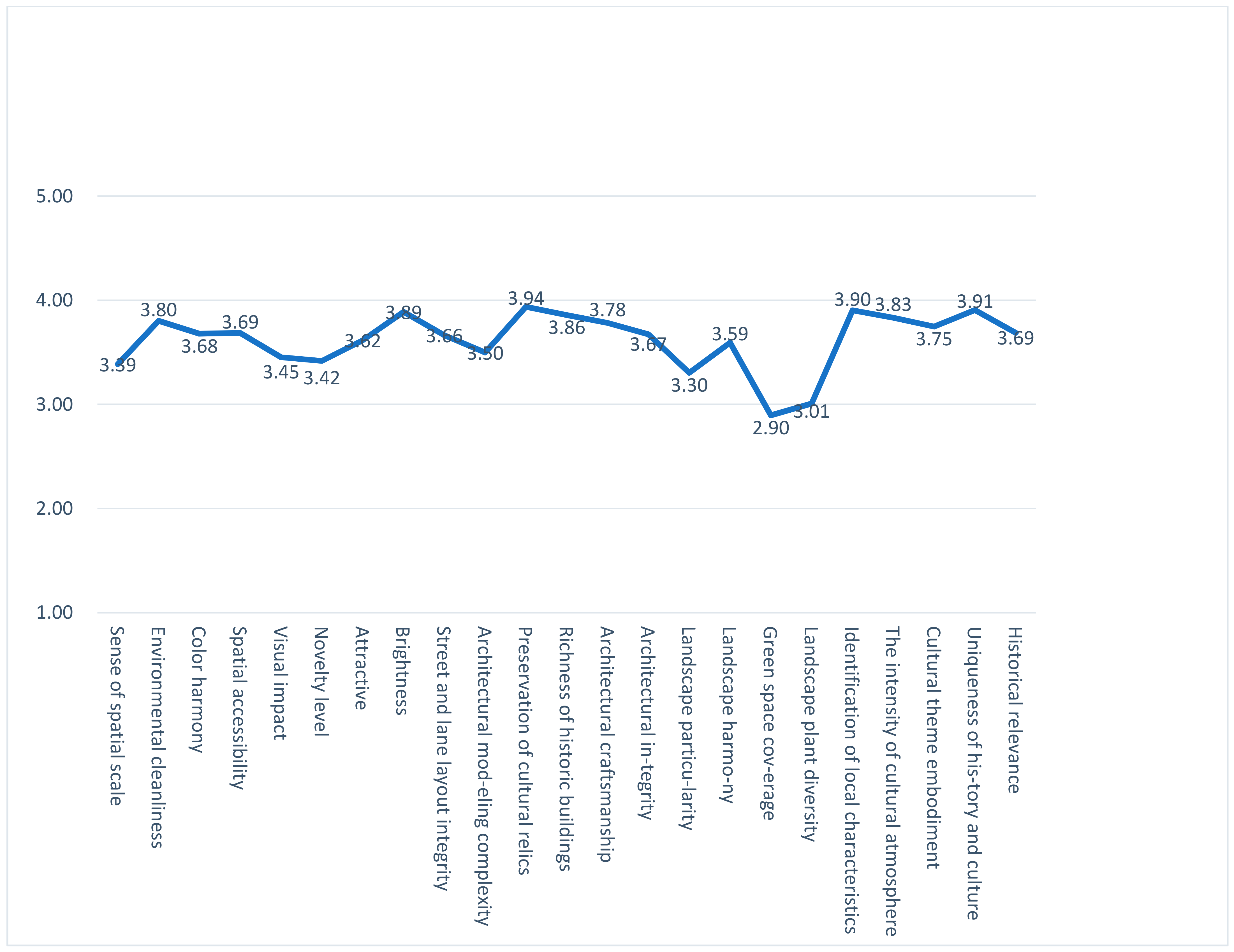
The final data statistics of 273 questionnaires were determined, and the average score of each evaluation factor was calculated to obtain the SD comprehensive evaluation table (
Table 8). Afterwards, the comprehensive evaluation curve of the block was drawn according to the comprehensive evaluation table (
Figure 2). The performance of the nine historical streets and alleys in each evaluation factor can be clearly seen from the line chart.
As can be seen from the comprehensive evaluation curve, in the comprehensive evaluation of the nine historical streets and alleys, the curves tend to be on the upper side and close to the positive direction as a whole. Among them, 22 evaluation factors score between 3–4, that is, the subjects are basically satisfied with these 22 evaluation factors. Among them, the cultural relics and historic sites preservation degree (3.94) score is the highest, indicating that the cultural relics and historic sites are well protected in the nine historical streets and lanes. In the figure, only one evaluation factor is lower than 3, and the green space coverage rate (2.90) is poor, indicating that the landscape greening of these nine historical streets and lanes is low.
5.4. Visual Evaluation of Various Historical Streets and Alleys
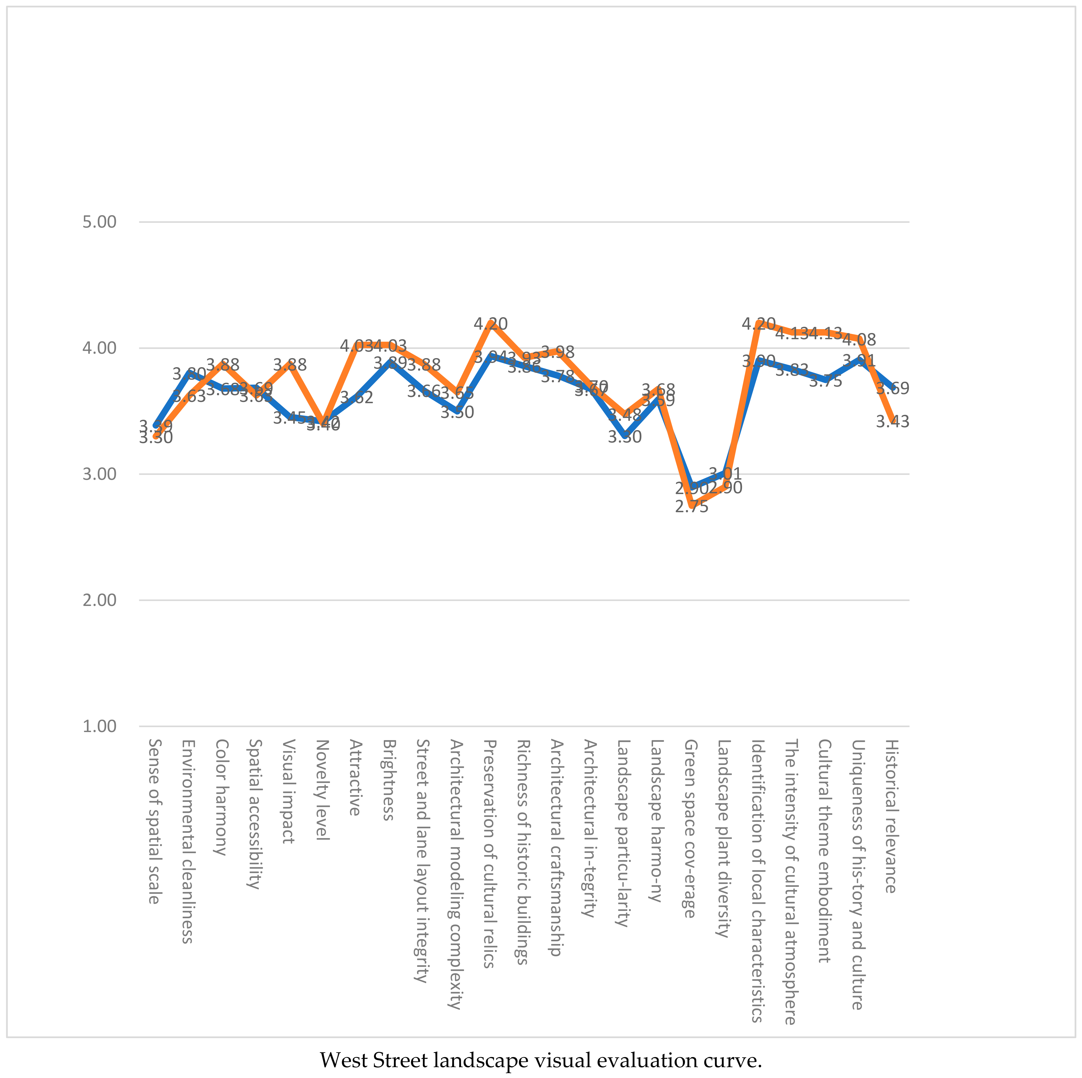
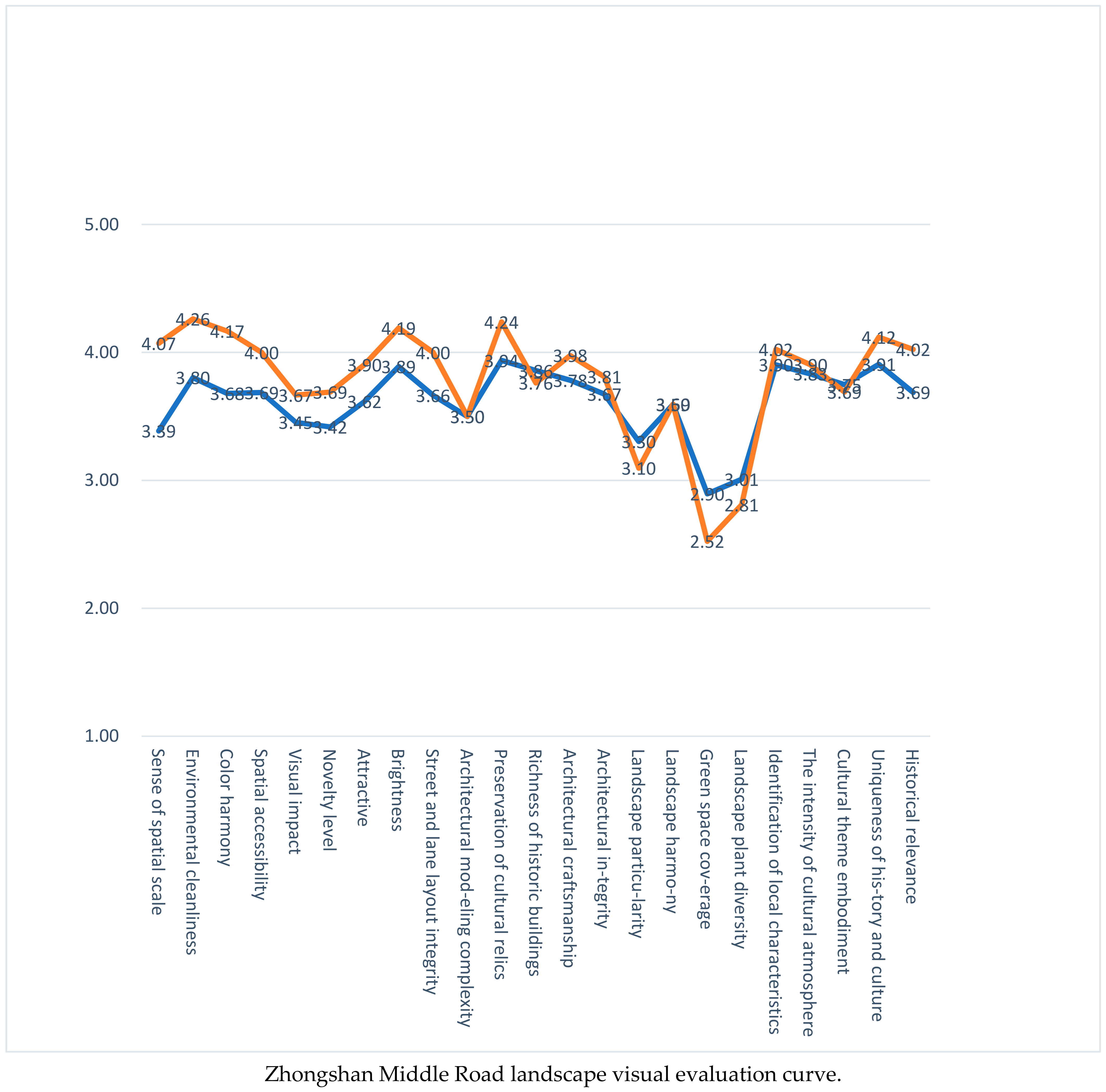
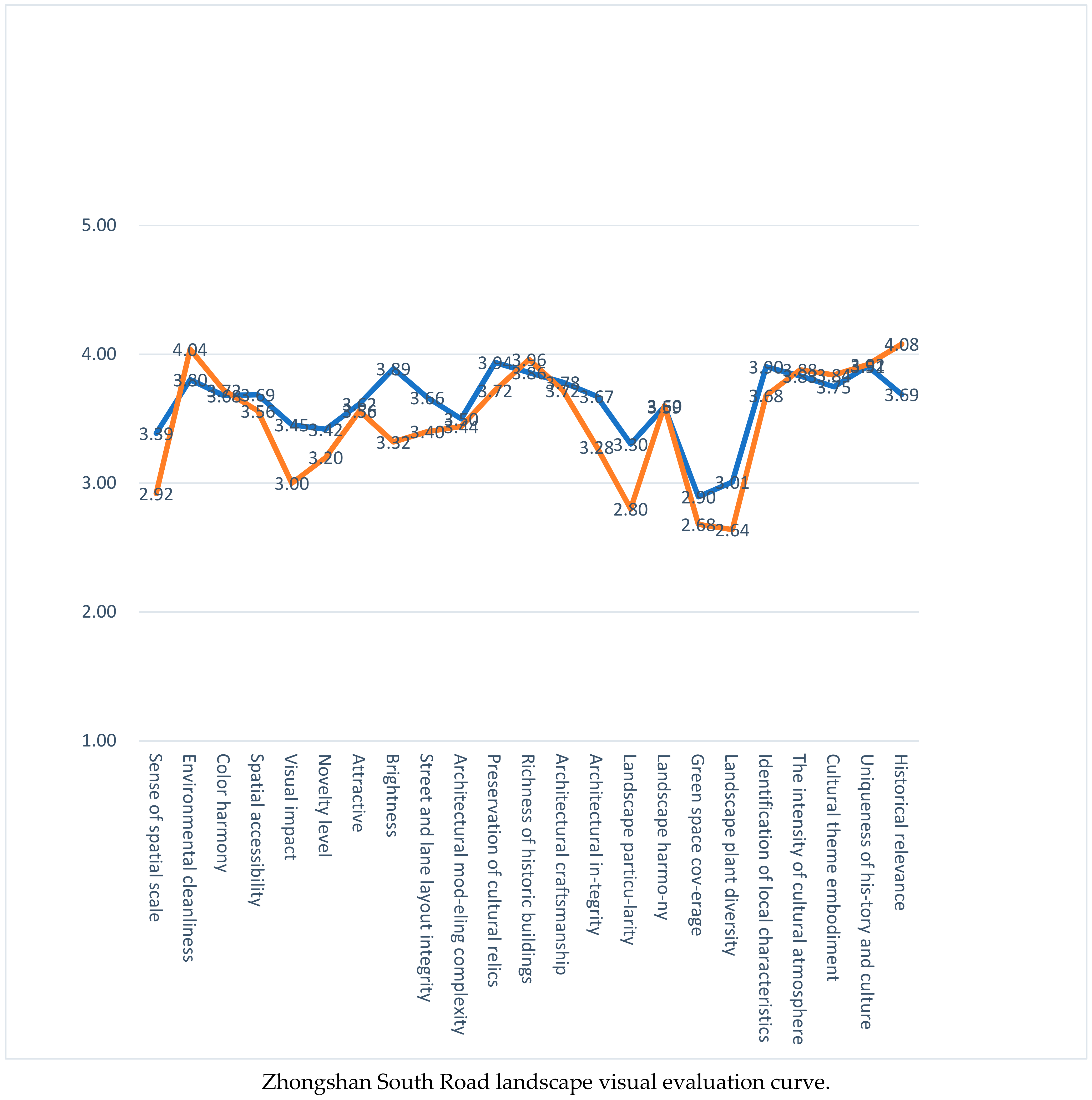
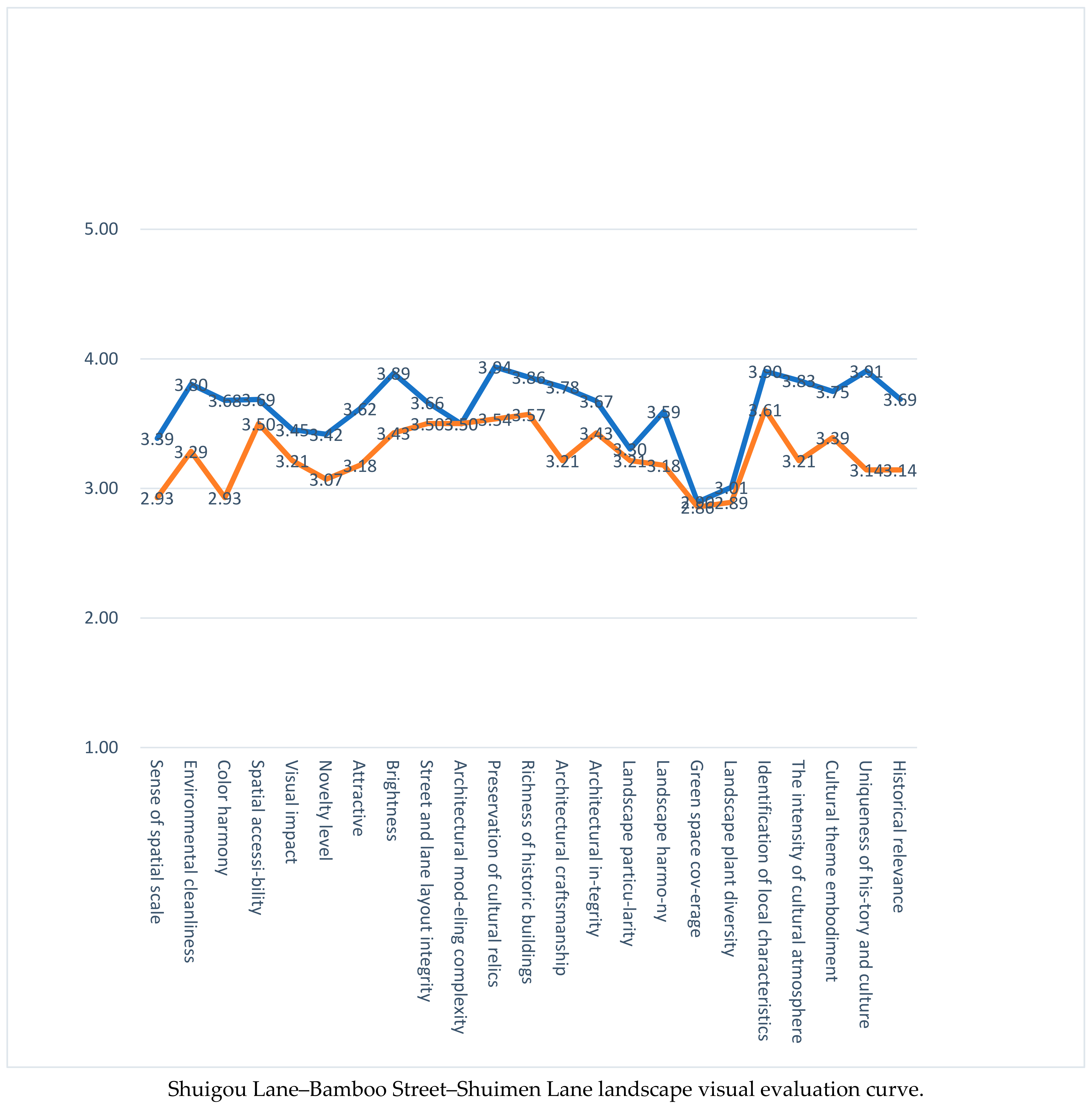
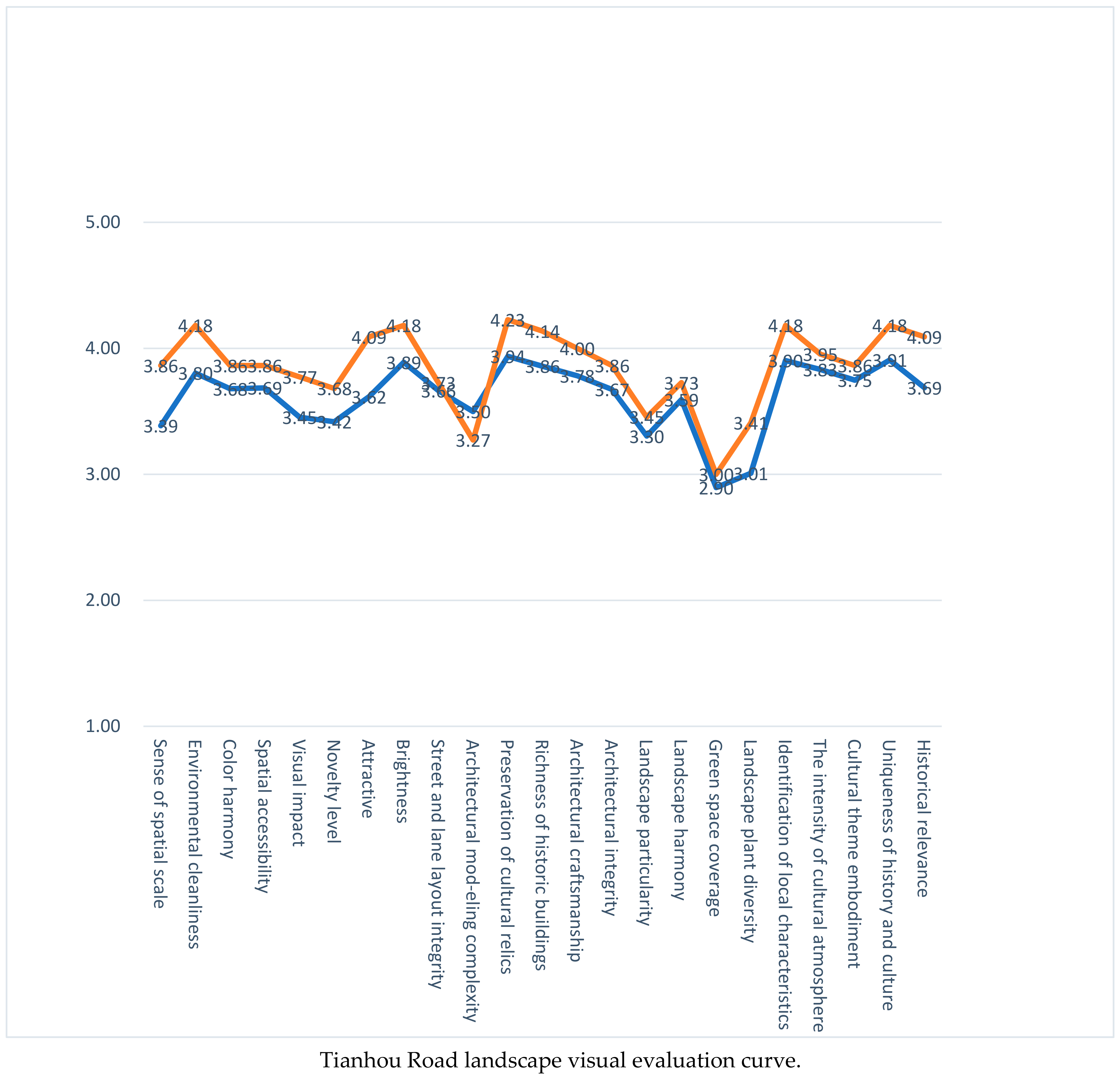
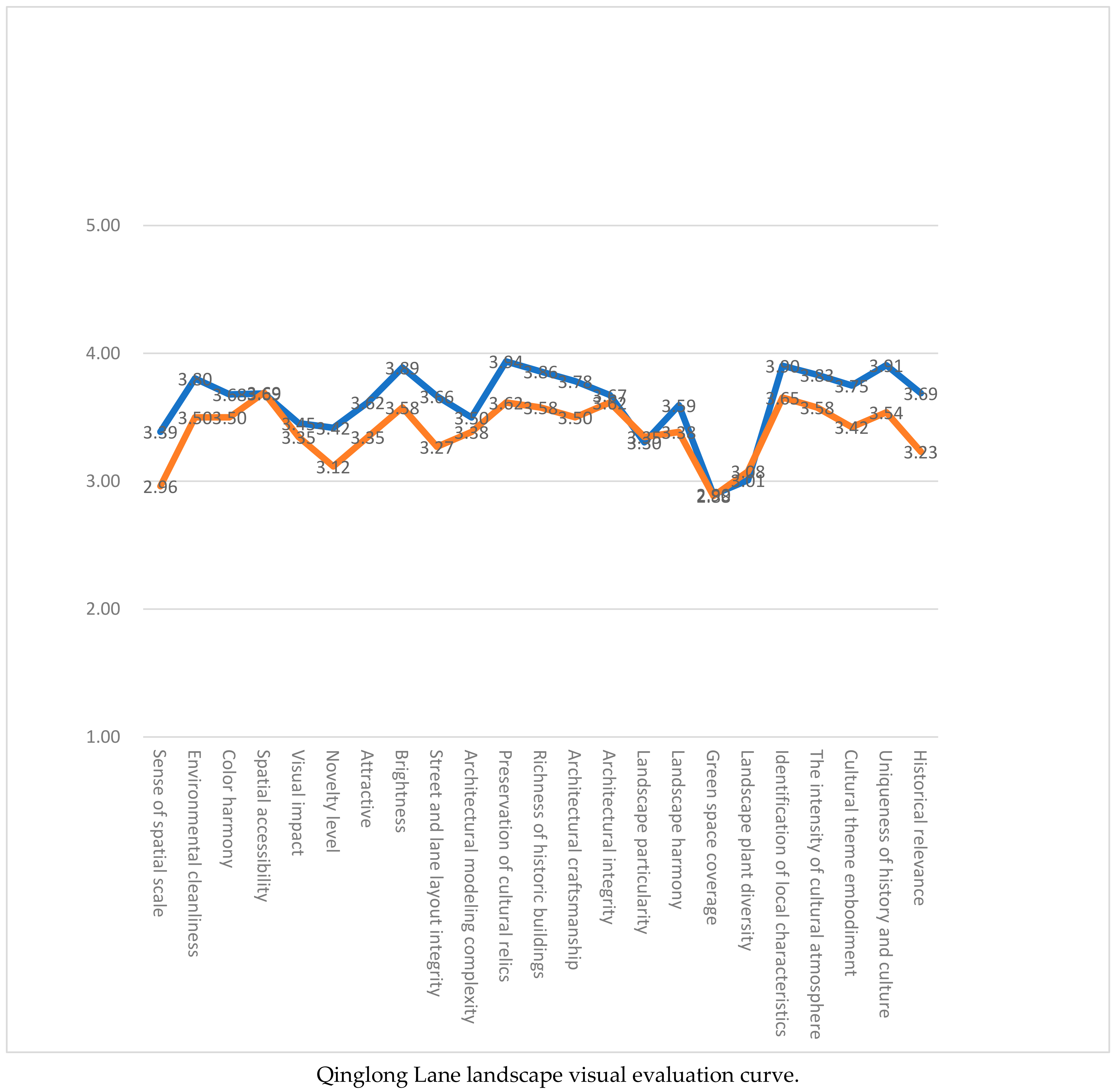
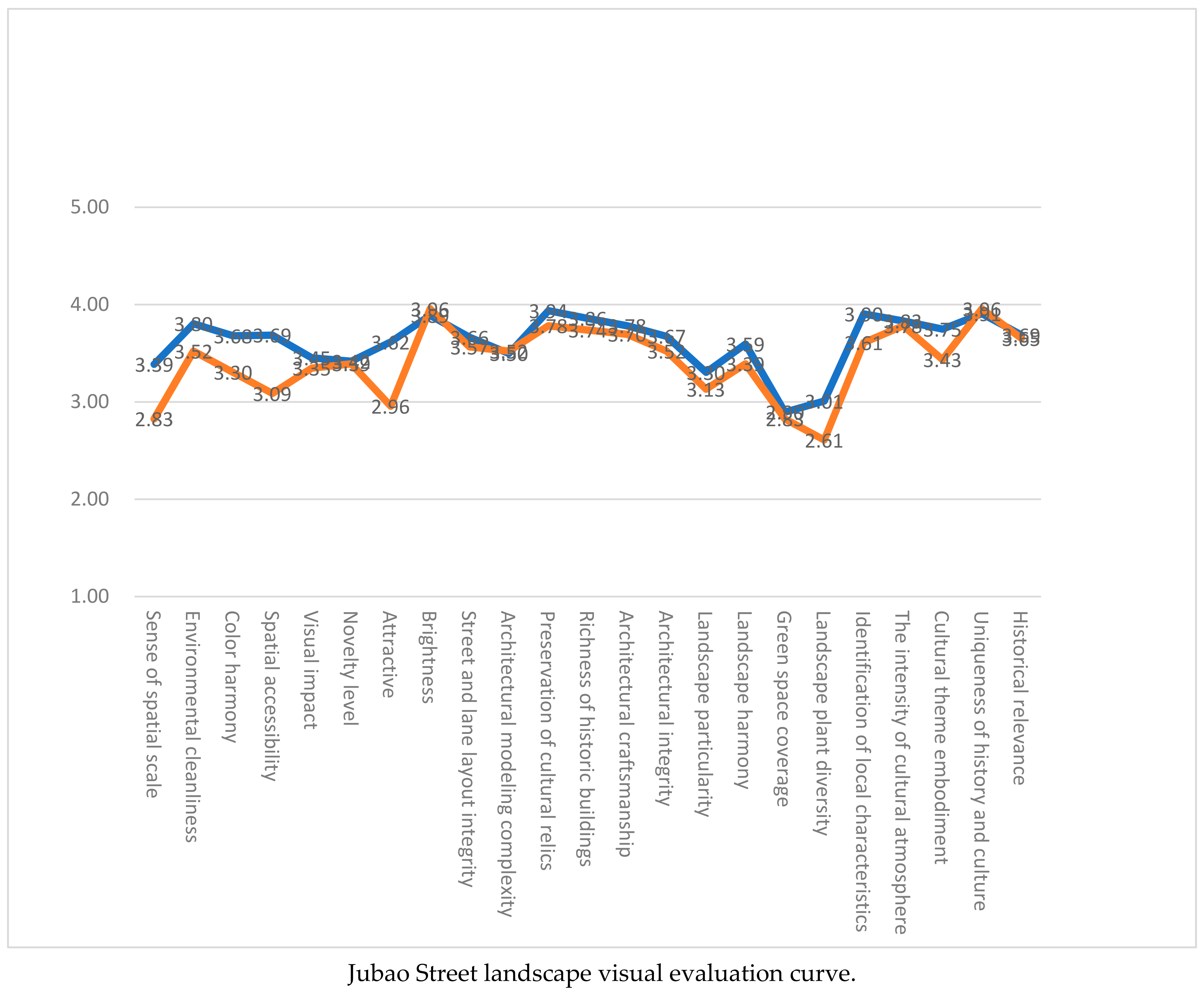
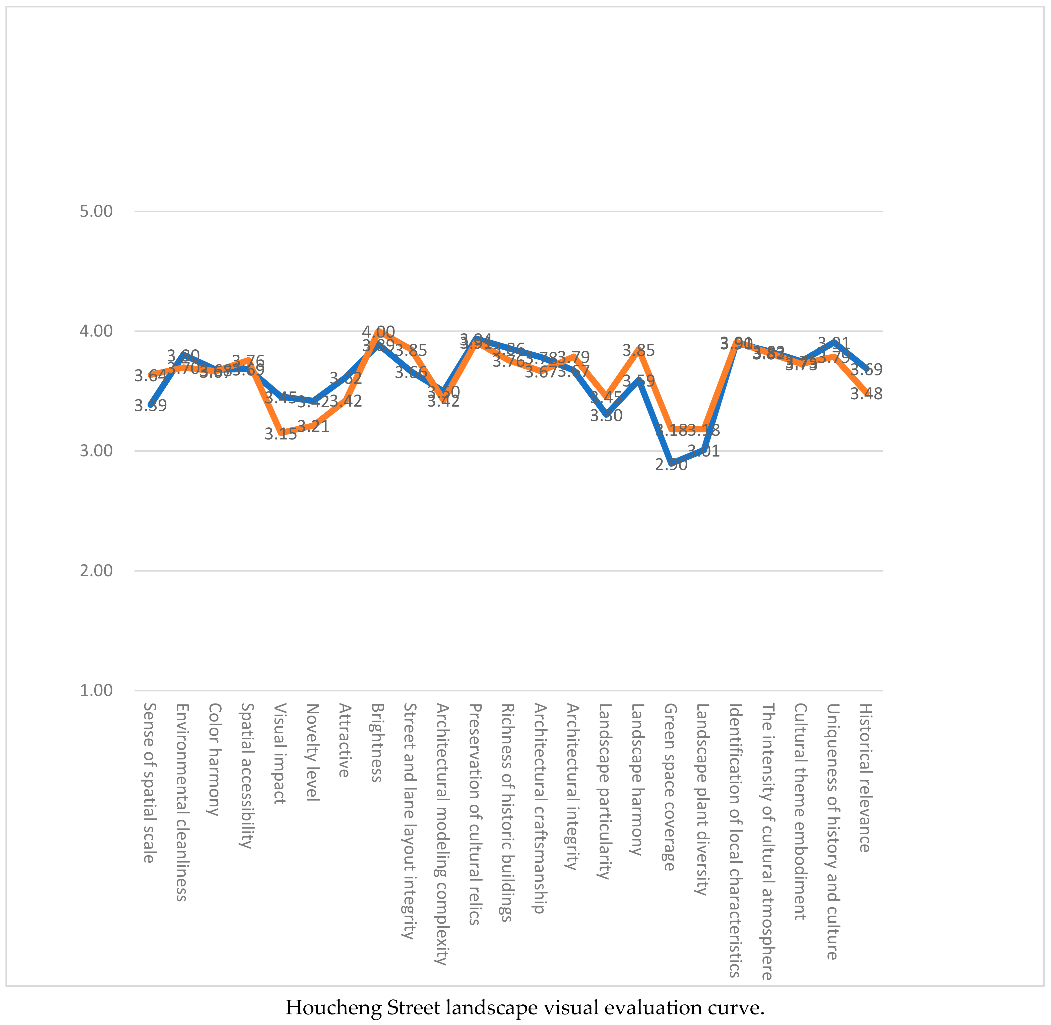
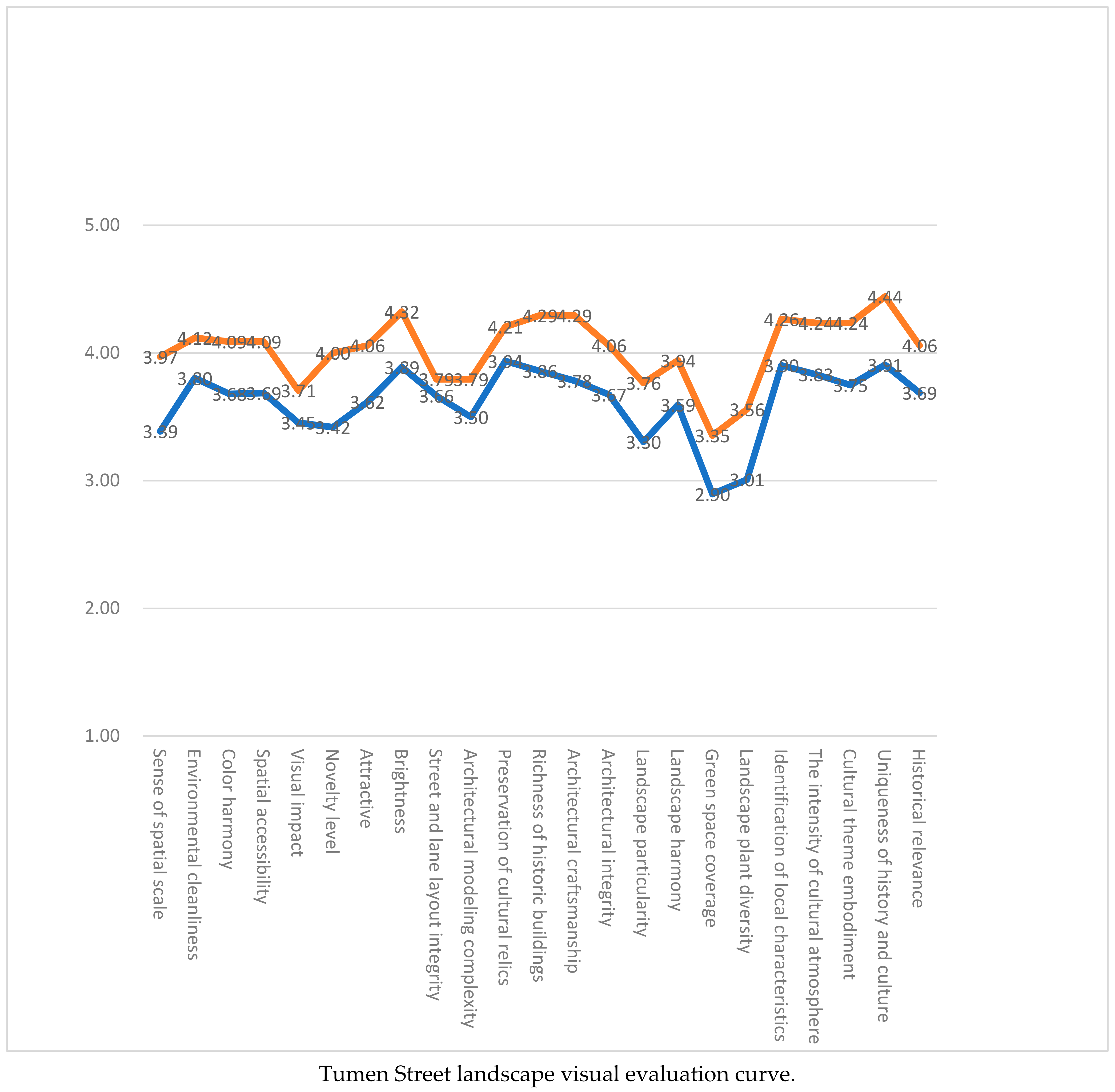
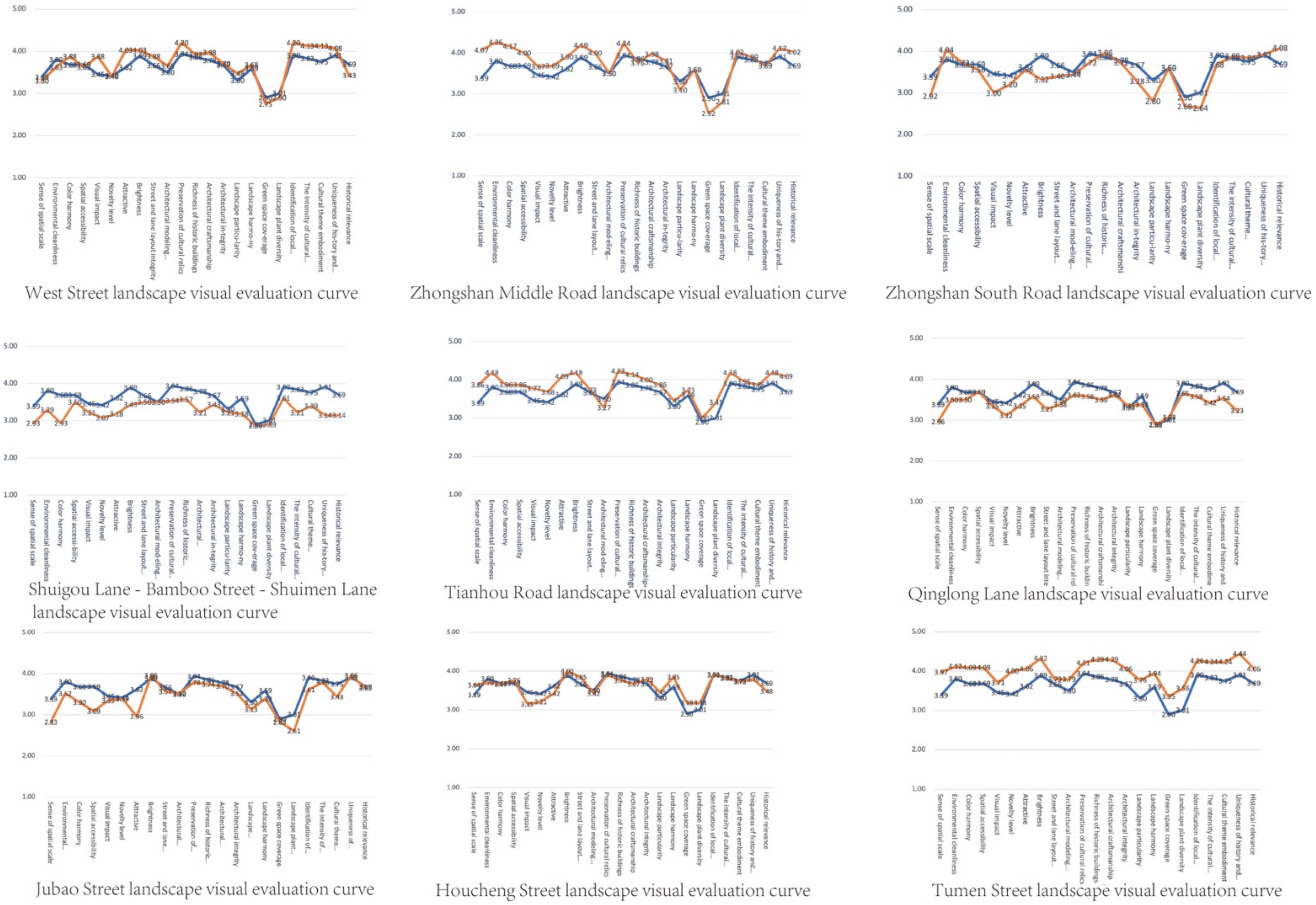
The evaluation curves and analysis of various historical streets and alleys are shown below (
Figure 3). Comparing each line chart, the blue represents the average score, the orange represents the evaluation score of each street’s landscape, and their contrast can reveal the bias of each factor in the performance of each street’s landscape. (Detailed analysis of each historical street is shown in
Appendix B Figure A2).
As can be seen from the figure, the relationships between the characteristic performance of streets and alleys in each block and the average level are quite different, but they also reflects a certain regularity. On the one hand, factors such as the brightness of streets and lanes in each block are above average, the blocks’ sense of spatial scale is higher, there is no high coverage, and a strong history and culture can reflect the historical and cultural characteristics of a certain period. On the other hand, the overall vegetation coverage of the street space in each block is obviously lower than the average, and there are no significant landscape plant characteristics. Therefore, the landscape evaluation of the streets and lanes in the blocks can be summarized as follows: they have strong regional identification characteristics, there is a high degree of historical building protection and inheritance, and street and lane spaces have a relatively complete landscape style, but the vegetation coverage rate is low, and the diversity of landscape plants is not rich enough.
6. Factor Analysis
The quantitative data obtained by SD method were rearranged according to the format requirements of SPSS analysis software for factor analysis and then input into the software for further analysis. Then, a series of analysis results were generated, and then the results were analyzed and evaluated.
6.1. Determination of the Number of Factors
The SD method was used to conduct a questionnaire survey to analyze and judge the landscape of nine historical streets and lanes in four historical and cultural blocks in Quanzhou Ancient City. The quantitative data obtained from the questionnaire were the basis for factor analysis. The method of factor analysis was used to comprehensively analyze the quantitative data obtained above.
Before determining the number of factors, the correlation between the 23 evaluation factors in the SD questionnaire for the visual evaluation of historical street and alley landscape was analyzed to confirm that there was a certain correlation. Among them, there were two main methods used to test the correlation, a KMO (Kaiser–Meyer–Olkin) Test and Bartlett Test of Sphericity.
A KMO (Kaiser–Meyer–Olkin) test judges the correlation between variables by comparing the size of simple correlation coefficient and partial correlation coefficient between variables. When the correlation is strong, the partial correlation coefficient is much smaller than the simple correlation coefficient, and the KMO value is close to 1. In general, KMO ≥ 0.9 is very suitable for factor analysis. In this study, 0.8 < KMO ≤ 0.9 represented suitable; 0.7 ≤ KMO < 0.8 was fair; 0.6 ≤ KMO < 0.7 had poor effect; KMO ≤ 0.5 was not suitable for factor analysis.
The Bartlett Test of Sphericity is used to check whether a correlation matrix is a unit matrix, that is, whether the variables are independent of each other. It takes the correlation coefficient matrix of variables as the starting point and assumes that the correlation coefficient matrix is an identity matrix. If the statistical value of Bartlett sphericity test is large and its associated probability value is smaller than the significance level given by the user, the null hypothesis should be rejected, indicating that it is suitable for factor analysis. On the contrary, the null hypothesis cannot be rejected, and the correlation coefficient matrix may be an identity matrix, which is not suitable for factor analysis. If the hypothesis cannot be negated, it indicates that these variables may provide some information independently and lack common factors.
According to the two correlation test methods mentioned above, quantitative data were imported into SPSS software for correlation test. SPSS software was successfully developed by Norman H. Nie, C. Hadlai (Tex) Hull and Dale H. Bent of Stanford University in 1968 and acquired by IBM in 2009. With the help of the factor analysis function of SPSS 22.0 verison, and the data were obtained as follows (
Table 9):
It can be seen from the table that the Bartlett sphericity test statistic is 2844.062 and the corresponding probability Sig is 0.000, so the difference between the correlation coefficient matrix and the identity matrix can be considered significant. Meanwhile, the KMO value is 0.934, which is very suitable for factor analysis according to the KMO metric given by Kaiser.
After testing the correlation of 23 factors, it was determined that the data could be analyzed by factor analysis. SPSS software was used to obtain the total variance interpretation table after factor rotation when the eigenvalue was greater than 1 (shown in
Table 10).
Reading the table, it can be seen that the first five common factors in all the variables selected in this study can evaluate and explain the internal relations of 61.332% of the historical street and lane landscapes. The cumulative variance of the final factor solution of the third column in the table after orthogonal rotation is the same as the value before rotation. Among the common factors, common factor 1 can be used to analyze and explain 18.96%, common factor 2 11.609%, common factor 3 11.018%, common factor 4 9.929% and common factor 5 9.815% of landscape relations. It can be seen that these five common factors are the main factors constituting the 23 evaluation items, and the effect of factor analysis is ideal and has certain credibility.
6.2. Common Factor Extraction and Naming
There is also a factor load matrix in the factor analysis results. The factor load matrix groups the initial evaluation factors that are most closely related to the five common factors, that is to say, each common factor has several aspects of the historical street and lane landscape that it represents, and the appropriate common factor name can be selected according to the aspects it represents. Naming should take into account the common factor that represents every aspect of the street landscape as far as possible to be as comprehensive and concise as possible.
Table 11 shows that with the common factor 1, there are eight closely correlated initial evaluation factors, which are historical events, historical and cultural uniqueness, cultural theme embodiment, strong cultural atmosphere, local feature recognition degree, exquisite workmanship, overall style integrity, and cultural relics reserves, mainly described by historical and cultural landscape of blocks. Therefore, common factor 1 is called historical and cultural factors. In the same way, factors 2–5 were named as spatial environment factor, architectural site factor, sensory experience factor and landscape greening factor, respectively.
6.3. Factor Score and Composite Score Ranking and Correction
Factor analysis results also include factor score coefficients (see
Table 12).
According to the factor scoring coefficient matrix, the corresponding common factor scoring function formula is as follows:
The variance contribution rate of each common factor is weighted and summarized as the weight, and then the calculation formula of the visual evaluation of each historical street and lane landscape is obtained, from which the comprehensive score of each historical street and lane landscape can be obtained. The calculation formula is as follows:
(F = each historical street landscape comprehensive score, F1—historical cultural factor, F2—spatial environment factor, F3—architectural site factor, F4—sensory experience factor, F5—landscaping factor.)
According to the formula, the score of each common factor, the comprehensive score and the ranking order are as follows (shown in
Table 13).
6.4. Factor Analysis Conclusion
The evaluation score was corrected by percentage system, and then the common factors of historical streets and lanes in Quanzhou city were divided into three grades from high to low. Scores of 75 and above are “excellent”, between 65 and 75 “fair”, and below 65 “poor”. Finally, the analysis and evaluation table of landscape factors of historical streets and alleyways in Quanzhou city was obtained (
Table 14).
It can be seen from
Table 14 that the comprehensive evaluation scores of the samples of nine historical streets and lanes from high to low are as follows: Tumen Street, Tianhou Road, Zhongshan Middle Road, West Street, Houcheng Street, Zhongshan South Road, Jubao Street, Qinglong Lane and Shuigou Lane–Bamboo Street–Shuimen Lane.
Tumen Street and Tianhou Road ranked first and second, respectively, because the historical and cultural factors and spatial environment factor performed well, while the architectural site factor and sensory experience factor also performed well. Only the landscape greening factor received poor evaluation. The occurrence of this situation is mainly related to the spatial layout and cultural deposits of the block. Tumen Street and Tianhou Road retain a large number of traditional buildings with obvious historical and cultural characteristics and have not undergone a great amount of renovation, so they have relatively open space. Zhongshan Middle Road and West Street ranked third and fourth, respectively. Middle Zhongshan Road was evaluated well in three common factors, including historical and cultural factors, spatial environment factor and building site factor, while other factors were evaluated poorly, leading to it ranking third in comprehensive evaluation. West Street performed well in historical and cultural factors and building site factor and fairly in spatial environment factor and sensory experience factor. It was also evaluated poorly in landscape greening factor. The main reason for this situation is that the storefront along the street is mostly well-planned shops, and the architectural color collocation is chaotic, which affects the overall landscape coordination degree and the integrity of the overall style of the block to a certain extent and weakens the profoundness of the environmental experience. Houcheng Street and Zhongshan South Road ranked fifth and sixth, respectively. The historical and cultural factors, spatial environment factor and building site factor of Houteng Street were good, but sensory experience factors and landscape greening factors were poor. For Zhongshan South Road, only the historical and cultural factors were good, whereas the other four factors were acceptable and poor. The main reason for this situation is that Zhongshan Middle Road and West Street have a long history. Apart from the large-scale cultural heritage, they are both mostly the main activity centers for citizens. Jubao Street, Qinglong Lane and Shuimen Lane–Zhujie–Shuigou Lane ranked seventh, eighth and ninth, respectively. For Jubao Street, only the historical and cultural factors and the building site factors were good, while the other three factors were all poor. The five factors of Qinglong Lane were all fair and poor. For Shuimen Lane, Zhujie Lane and Shuigou Lane, only the construction site factor was acceptable, while the other factors were poor. This is because the three streets are adjacent to each other, and most of them are commercial spaces. Although there are a certain number of traditional buildings, their commercial functions are obvious, so they received low evaluation.
Based on the above results, it can be concluded that landscape greening in historical streets and lanes of Quanzhou is particularly worthy of attention. Greening construction in streets and lanes should be strengthened, and trees and flowers should be planted to form a rich green landscape to meet people’s spiritual and cultural needs. In addition, the public is more inclined towards spaces with broader vision and strong history and culture. If the cultural landscape in the block is more complete and the cultural atmosphere is stronger through good protection and renewal, the public’s visual perception of the cultural landscape in the whole block will be improved. At the same time, it is necessary to have a good plan for the commercial forms in the block, balance the relationship between commercial space and historical places, and not let the strong commercial atmosphere cover up the historical atmosphere of the streets.
7. Conclusions
In this paper, SD and FA were used to conduct test analysis and evaluation of nine historical street landscapes in four historical and cultural blocks in Quanzhou ancient city. The evaluation indicators are specific, avoiding subjective interference, and the evaluation results are quantified, which is an improvement compared with qualitative evaluation. The evaluation results have high reliability, which can supplement the existing evaluation system and further enrich the evaluation work.
Since the landscape of historical and cultural blocks in Fujian Province is widely distributed, and the blocks themselves are numerous, with each having its own characteristics, it is impractical to analyze the cultural landscape of each historical block. Therefore, after full investigation and comparison, nine representative streets in the four historical and cultural streets in Quanzhou City were selected as the research object, the cultural landscape of these nine blocks, to be systematically analyzed. The field SD research assessment questionnaire method was chosen, combined with the semantic analysis and factor analysis to process the data after quantitative analysis, and the result of the questionnaire has universality. To verify the relationships of the 23 variable factors in the SD questionnaire, factor analysis was undertaken to analyze the quantitative data, and five common factors were extracted from the 23 evaluation factors. Orthogonal rotation was used to ensure that the five common factors were mutually independent. According to the weight of each factor in the total variance of interpretation, the calculation formula of visual evaluation of cultural landscape in historical blocks was derived, and the samples of nine blocks were sorted according to the size of the score value. They are, successively, Tumen Street, Tianhou Road, Zhongshan Middle Road, West Street, Houcheng Street, Zhongshan South Road, Jubao Street, Qinglong Lane and Shuigou Lane–Bamboo Street–Shuimen Lane. The cultural landscape difference between the blocks was studied in depth, the causes of the situation were analyzed, and the evaluation methods can be used for reference. This study not only contributes to protecting and updating the cultural and architectural heritage of this historical and cultural district but also provides an innovative methodology, which can be used for scientific research on the landscape of the historical and cultural district in the future and provide scientific reference for the development and evaluation of other historical districts.
Future studies should consider using statistical data and relevant literature research at home and abroad to conduct field research on the research objects, combining the opinions and suggestions of experts and scholars in related fields, considering the applicable population of the block and using the form of questionnaire distribution, so that the questionnaire concerning the investigated objects can be filled more intuitively in the actual environment. This would support obtaining more specific and scientific conclusions, making the research results of this paper more authentic and reliable. Research objects would then show the characteristics of a wide range, a large span and a large number, which would address the current situation, in which the landscape visual evaluation of historical and cultural blocks lacks quantitative analysis. In addition, this study shifted from initially focusing on landscape visual evaluation as the object of study. In the process of research, it began to pay more attention to the cultural landscape of historical and cultural connotation and the emotional connection between people and space, according to the historical and cultural background and local characteristics, recognizing the culture of a historic district through cultural landscape visual evaluation and paying more attention to people’s real feelings. It emphasizes the dominant position of human beings in society.
Although the selection of adjectives in the questionnaire is scientific to some extent, based on prior investigation and expert opinion, it is inevitable that some attributes of the research object are not studied deeply enough. Furthermore, because human behavior is often easily affected by the objective environment and subjective emotions, it is easy to present a complex and changeable situation. Therefore, it is necessary to further study the methodology of behavioral science, such as environmental psychology, to broaden the research field and make the research results more comprehensive and objective.
8. Recommendations
- (1)
Formulate strict protection laws and policies to protect the cultural and architectural heritage in the blocks and balance the relationship between commercial development and historical inheritance.
- (2)
Enhance the public’s awareness of cultural heritage protection and encourage the public to participate in the landscape protection of historical and cultural blocks.
- (3)
The cultural characteristics of the historical and cultural streets should be preserved while carrying out the urban modernization construction.
- (4)
Encourage the development of historical folk activities to expand the cultural influence of the city.
- (5)
Through SD questionnaire analysis and factor analysis, it can be seen that the landscape greening in the historical and cultural street area of the city is poor. Therefore, attention should be paid to improving the overall greening style of the historical and cultural street area and properly developing a rich plant landscape.
- (6)
In the comprehensive evaluation of factor analysis, in order to obtain a good evaluation and a high score, it is necessary to have a good performance in the evaluation of various common factors.
- (7)
Encourage communities in historic city centers to focus on investing in potential existing historic sites to promote the modernization of historical and cultural buildings.
Author Contributions
Data Curation, Y.Z. (Yang Zhao), J.L. and Y.Z. (Yali Zheng); Methodology, Y.Z. (Yang Zhao); Software, J.L. and Y.Z. (Yali Zheng); Resources, Y.Z. (Yang Zhao); Formal analysis, J.L.; Writing—Original draft preparation, Y.Z. (Yali Zheng); Writing—Review and editing, Y.Z. (Yang Zhao). All authors have read and agreed to the published version of the manuscript.
Funding
This research received no external funding.
Institutional Review Board Statement
This research was approved by the Institution Review Board of authors’ university.
Informed Consent Statement
Informed consent was obtained from all subjects involved in the study.
Data Availability Statement
The data used to support the findings of this study are available from the corresponding author upon request.
Conflicts of Interest
The authors declare no conflict of interest.
Appendix A
Figure A1.
Landscape visual map of nine historic streets and alleys.
Figure A1.
Landscape visual map of nine historic streets and alleys.
Appendix B
Figure A2.
Visual evaluation map of nine historical streets and lanes in Quanzhou.
Figure A2.
Visual evaluation map of nine historical streets and lanes in Quanzhou.
References
- Jones, G.A.; Bromley, R.D.F. The relationship between urban conservation programmes and property renovation: Evidence from Quito, Ecuador. Cities 1996, 13, 373–385. [Google Scholar] [CrossRef]
- Prieto, I.; Izkara, J.L.; Béjar, R. Web-Based tool for the sustainable refurbishment in historic districts based on 3d city model. In Advances in 3D Geoinformation; Alias, A.R., Ed.; Springer International Publishing: Basel, Switzerland, 2017; pp. 159–169. [Google Scholar]
- Zhang, J.J.; Zhang, J.; Huo, X.W.; Zheng, W.H.; Zheng, X.; Zhang, M.M. Research on the positioning of protection and Utilization of Historic Districts Under Big Data Analysis. In Proceedings of the 26th International Symposium of ICOMOS/ISPRS-International-Scientific-Committee-on-Heritage-Documentation (CIPA) on Digital Workflows for Heritage Conservation, Ottawa, ON, Canada, 28 August–1 September 2017. [Google Scholar]
- Oliver, G. The Limitlessness City: A Primer on the Urban Sprawl Debate; China Architecture & Building Press: Beijing, China, 2007. [Google Scholar]
- Kırmızı, Ö.; Karaman, A. A participatory planning model in the context of Historic Urban Landscape: The case of Kyrenia’s Historic Port Area. Land Use Policy 2021, 103, 105130. [Google Scholar] [CrossRef]
- Acri, M.; Dobricic, S.; Debevec, M. Regenerating the Historic Urban Landscape through Circular Bottom-Up Actions: The Urban Seeding Process in Rijeka. Sustainability 2021, 13, 4497. [Google Scholar] [CrossRef]
- UNESCO. Recommendation on the Historic Urban Landscape; UNESCO: Paris, France, 2011. [Google Scholar]
- Ramos, I.L.; Bianchi, P.; Bernardo, F.; Van Eetvelde, V. What matters to people? Exploring contents of landscape identity at the local scale. Landsc. Res. 2019, 44, 320–336. [Google Scholar] [CrossRef]
- Farhan, S.; Akef, V.; Nasar, Z. The transformation of the inherited historical urban and architectural characteristics of Al-Najaf’s Old City and possible preservation insights. Front. Archit. Res. 2020, 9, 820–836. [Google Scholar] [CrossRef]
- Kononowicz, A. Cultural heritage protection issues in Leśnica, the settlement of Wrocław. Civ. Environ. Eng. Rep. 2015, 18, 85–96. [Google Scholar] [CrossRef] [Green Version]
- Rodwell, D. Conservation and Sustainability in Historic Cities; Wiley-Blackwell Press: Hoboken, NJ, USA, 2007. [Google Scholar]
- Burtenshaw, D.; Bateman, M.; Ashworth, G.J. The European City: A Western Perspective; David Fulton Publishers: London, UK, 1991; pp. 56–58. [Google Scholar]
- Tiamsoon, S. Conservation of Bangkok old town. Habitat Int. 2009, 33, 405–411. [Google Scholar]
- Zhang, W.Y. A review of research on preservation and development of urban historic Blocks abroad. J. Jinling Inst. Sci. Technol. (Soc. Sci. Ed.) 2007, 21, 56. (In Chinese) [Google Scholar]
- Davidoff, P. Advocacy and pluralism in planning. J. Am. Plan. Assoc. 1965, 31, 331–338. [Google Scholar] [CrossRef]
- Innes, J.E. Planning through consensus building: A New View of the Comprehensive Planning ideal. J. Am. Plan. Assoc. 1996, 62, 460–472. [Google Scholar] [CrossRef]
- Hu, Y.; Ritchie, J.B. Measuring destination attractiveness: A contextual approach. J. Travel Res. 1993, 32, 25–34. [Google Scholar]
- Fotsch, P.M. Tourism’s uneven impact: History on Cannery Row. Ann. Tour. Res. 2004, 31, 779–800. [Google Scholar] [CrossRef]
- Sobotka, L.A.; Ramsey, M.L.; Wellner, M. Rare cause of dysphagia after esophageal variceal banding: A case report. World J. Gastrointest. Endosc. 2019, 11, 292–297. [Google Scholar] [CrossRef]
- Falk, N. Baltimore and Lowell: Two American approaches. Built Environ. 1986, 12, 145–152. [Google Scholar]
- Meethan, K. Consuming in the civilized city. J. Ann. Tour. Res. 1996, 13, 322–340. [Google Scholar] [CrossRef]
- Kotler, P.; Bowen, J.T.; McCann, J.C. Tourism Marketing; Mechanical Industry Press: Norwalk, UK, 2018. [Google Scholar]
- Frochot, I.; Hughes, H. HISTOQUAL: The development of a Historic House Assessment Scale. Tour. Manag. 2000, 21, 157–167. [Google Scholar] [CrossRef]
- Zhang, H.; Cho, T.; Wang, H.; Ge, Q. The influence of cross-cultural awareness and tourist experience on authenticity, tourist satisfaction and acculturation in World Cultural Heritage Sites of Korea. Sustainability 2018, 10, 927. [Google Scholar] [CrossRef] [Green Version]
- Duarte, C.; Morais, A. Paving the way to NZEB on two historical blocks in Lisbon pombaline quarter. IOP Conf. Ser. Mater. Sci. Eng. 2019, 603, 022032. [Google Scholar] [CrossRef]
- Acosta, A.; Carranza, M.L.; Giancola, M. Landscape change and ecosystem classification in a municipal district of a small city (Isernia, Central Italy). Environ. Monit. Assess. 2005, 108, 323–335. [Google Scholar] [CrossRef]
- Pourzakarya, M.; Bahramjerdi, S.F.N. Towards developing a cultural and creative quarter: Culture-led regeneration of the historical district of Rasht Great Bazaar, Iran. Land Use Policy 2019, 89, 104218. [Google Scholar] [CrossRef]
- Ghorbani, F.E.; Ranjbar, E.; Andalib, A. Identifying Culture-led Regeneration Strategies in Historical Districts of Iranian Cities: The Case of Feizabad Neighborhood of Kermanshah. Bagh-E Nazar 2021, 18, 113–118. [Google Scholar]
- Atik, M.; Isikli, R.C.; Ortacesme, V. Clusters of landscape characters as a way of communication in characterisation: A study from side, Turkey. J. Environ. Manag. 2016, 182, 385–396. [Google Scholar] [CrossRef]
- Forczek-Brataniec, U. Assessment of Visual Values as a Tool Supporting the Design Decisions of the Cultural Park Protection Plan. The Case of Kazimierz and Stradom in Krakow. Sustainability 2021, 13, 6990. [Google Scholar] [CrossRef]
- Forczek-Brataniec, U. Visible Space: A Visual Analysis in the Lanscape Planning and Designing; Cracow University of Technology: Cracow, Poland, 2018. [Google Scholar]
- ICOMOS. Xi’an Declaration on the Conservation of the Setting of Heritage Structures, Sites and Areas; ICOMOS: Paris, France, 2005. [Google Scholar]
- Krause, C.L. Our visual landscape managing the landscape under special consideration of visual aspects. Landsc. Urban Plan. 2001, 54, 239–254. [Google Scholar] [CrossRef]
- Daniel, T.C.; Boster, R.S. Measuring Landscape Esthetics: The Scenic Beauty Estimation Method; Research PaperRM-RP-167; U.S. Department of Agriculture, Forest Service, Rocky Mountain Range and Experiment Station: Fort Collins, CO, USA, 1976. [Google Scholar]
- Hresko, J.; Kanasova, D.; Petrovic, F. Landscape Arche- types as the Elements of Slovak Historical Landscape Structure. Ekológia 2010, 29, 158–173. [Google Scholar] [CrossRef]
- Mahanna, W.A. Urban renewal for traditional commercial streets at the historical centers of cities. Alex. Eng. J. 2019, 58, 1127–1143. [Google Scholar] [CrossRef]
- Osgood, C.E.; Suci, G.J.; Tannenbaum, P.H. The Measurement of Meaning; University of Illinois Press: Urbana, IL, USA, 1957. [Google Scholar]
- Murakami, T.; Kroonenberg, P.M. Three-mode models and individual differences in semantic differential data. Multivar. Behav. Res. 2003, 38, 247–283. [Google Scholar] [CrossRef]
- Ellis, S.P. Instability of statistical factor analysis. Proc. Am. Math. Soc. 2004, 132, 1805–1822. [Google Scholar] [CrossRef]
- Champion, V.; Austin, J.; Tzeng, O.C.S. Cross-cultural comparison of images of nurses and physicians. Int. Nurs. Rev. 1987, 34, 43–48. [Google Scholar]
- Klettner, S. Affective Communication of Map Symbols: A Semantic Differential Analysis. ISPRS Int. J. Geo-Inf. 2020, 9, 289. [Google Scholar] [CrossRef]
| Publisher’s Note: MDPI stays neutral with regard to jurisdictional claims in published maps and institutional affiliations. |
© 2022 by the authors. Licensee MDPI, Basel, Switzerland. This article is an open access article distributed under the terms and conditions of the Creative Commons Attribution (CC BY) license (https://creativecommons.org/licenses/by/4.0/).
