Article

Evolution and Effects of the Social–Ecological System over 600 Years in Guizhou Province, China

1
School of Geographic and Environmental Sciences, Guizhou Normal University, Guiyang 550001, China
2
The State Key Laboratory Incubation Base for Karst Mountain Ecology Environment of Guizhou Province, Guiyang 550001, China
*
Author to whom correspondence should be addressed.
Sustainability 2022, 14(13), 7688; https://doi.org/10.3390/su14137688
Submission received: 7 May 2022 / Revised: 7 June 2022 / Accepted: 13 June 2022 / Published: 23 June 2022

Abstract

:
Understanding the regime shifts of Social–Ecological Systems (SES) and their local effects and driving factors over a long period of time is significant for future sustainability. We provide a perspective on the processes unfolding over time in order to identify the regime shifts of an SES based on changes in the relationships between the SES components. In addition, we investigate their driving factors and local effects. The applicability of this approach is demonstrated by analyzing the evolution of the SES in Guizhou Province, China, over the past 600 years. Six evolutionary phases are identified: the slow expansion of cultivation, the rapid expansion of cultivation, the continuous expansion of cultivation, the slower expansion of cultivation, the transformation of ecological protection driven by returning farmland to forest, and green development driven by urbanization. Our study establishes the empirical relationship between the state (phase) of the SES and its driving factors and effects. This study on the evolution, driving factors, and effects of the SES in Guizhou Province, China, provides an important reference for long-term regional planning and policy making.

1. Introduction and Literature Review

With the deepening influence of human beings on the natural environment, human activities have gradually become a primary factor in surface processes, and ecosystems have become seriously threatened and destroyed, such that the future social–ecological system (SES) faces severe challenges [1,2]. The phrase ‘social–ecological system’ (SES) refers to the interaction between human beings and environmental complexity, nonlinearity, and uncertainty, and the multi-layer nesting of the coupling system [3,4]. In the face of the complexity of environmental problems, multidisciplinary research has gradually developed. The theoretical framework of the social–ecological system is considered to be a potential analytical method and frontier of science [5,6]. The social–ecological feedback mechanism is the core content of social–ecological system research. Driven by global changes and human activities, social systems and ecosystems are undergoing increasingly dynamic changes. Revealing the mutual feedback mechanism of coupled systems is the scientific basis for maintaining and enhancing the elasticity and sustainability of systems, and it is also the main difficulty of current research [7]. Previous research analysis frameworks focused on vulnerability [4], resilience [8,9] and integrated ecosystem service evaluation [9,10]. With the deepening of human influence on the earth [11], the social–ecological system analysis framework has attracted a great deal of attention from scholars in China and abroad [12,13,14]. Due to the differences of the ecological environment and economic development level between regions, a case-based analysis framework is difficult to apply to specific regions [15]. Secondly, from the perspective of research, previous research on social–ecological systems has mainly focused on the exploration of theoretical frameworks and policy management. Although framework coupling analysis and regional management strategies have been proposed [16], it is still necessary to strengthen research on the description of the evolution process and the method of the feedback process, as well as the analysis of its driving factors and effects.
Guizhou Province is an ideal area for studying social–ecological interaction and its impact. Due to its karst environment and the influence of human beings through the irrational use of land, the soil erosion in the karst areas of Guizhou Province has intensified, and the surface soil layers have been lost in many areas, making Guizhou Province one of the areas with the most acute contradiction between humanity and the environment [17]. Due to the increasing population, especially since the establishment of Guizhou Province in the past 600 years during the Ming Dynasty, the cropland area in Guizhou Province has been expanding, and has even developed in areas with steep slopes [18]. The expansion of agriculture has led to the destruction of vegetation, which has intensified soil erosion and increased the area of rocky desertification [19]. For a long time, serious soil erosion, low agricultural productivity, and the situation of there being more people and less land have been the prominent problems faced during regional development. Since the 1980s, the government has implemented a series of governance measures and ecological projects to solve these problems. With the development of projects such as returning farmland to forest and the comprehensive management of rocky desertification, the area of rocky desertification in Guizhou Province has decreased significantly [20] and the vegetation coverage has increased [21].
In summary, from the perspective of the social–ecological system, in this study, the evolution, driving factors, and effects of social–ecological systems on long timescales were analyzed. This research provides a framework for the determination of the evolutionary phases by changing the interactions between the system components over time, and it pays attention to the driving factors and effects. Taking the evolution of the social–ecological system in Guizhou Province during the last 600 years as an example, the feasibility of the framework was demonstrated. Because the past, present, and future are inseparable, this study helps us to understand how the problems of Guizhou’s social–ecological system emerged in the past, how they have been solved, what new problems have emerged in the process of solving the original problems, and their implications for future social–ecological system management.

2. Materials and Methods

2.1. Framework

In this study, a research framework for the identification of the evolutionary phases of the social–ecological system based on the interactions between the changes in the system components (Figure 1) was constructed based on the social–ecological system steady-state transformation and social–ecological network. This framework is conducive to the identification of the evolutionary phase caused by the interactions among the components of the social–ecological system. It is assumed that the interactions among the components of the social–ecological system are constant in one phase of the evolution of the social–ecological system within the framework, and the evolution caused by these interactions (such as from a positive correlation to a negative correlation, or vice versa) represents the evolution of the system from one phase to another. The framework can better understand changes in elements (e.g., population, forest) through color changes. The fundamental reasons for the evolution of the interactions between the components of the social–ecological system are human activities and climate factors, and the changes in the system have subsequent effects and impacts. The Piecewise Linear Regression (PLR) method [22] was used to determine the turning point in the relationships between the social–ecological system components, to divide each relationship into several periods, and to determine the evolutionary phase of the social–ecological system by identifying the period when all of the relationships remained unchanged.
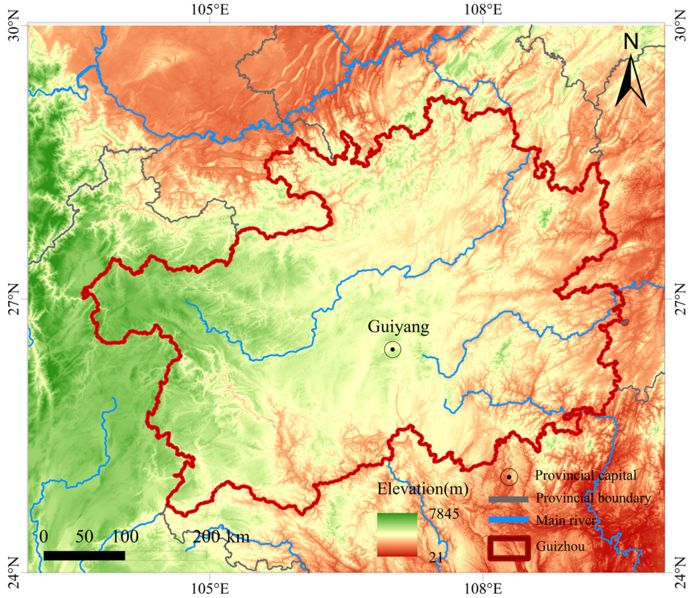
The study area was Guizhou Province (Figure 2). Guiyang is the capital of Guizhou Province. Guizhou Province is located on the Yunnan–Guizhou Plateau, bordering Hunan to the east, Guangxi to the south, Yunnan to the west, and Sichuan and Chongqing to the north. Guizhou Province has jurisdiction over 6 prefecture-level cities and 3 autonomous prefectures, with a total area of 176,167 square kilometers. Guizhou Province is not only a transportation hub in Southwest China but also an important part of the Yangtze River Economic Belt. In the eleventh year of Yongle in the Ming Dynasty, Guizhou was formally established as a provincial administrative region. Guizhou Province has existed for nearly 600 years, and has experienced rapid population growth, the expansion of arable land [23], and environmental damage and recovery processes. In order to understand the evolution of the social–ecological system in Guizhou Province in the last 600 years, three social–ecological components (population, cropland area, and forest coverage) were selected, the interactions between the changes in each component were identified, and the evolutionary phase of the Guizhou social–ecological system was determined according to the changes in these interactions. The core problems that Guizhou Province has been facing for a long time are population growth and an insufficient cropland area for food production. Cropland not only connects the social system and the ecosystem through land use but also plays a vital role in regional food security. Therefore, the population and cropland area were selected to represent the social system components. The forest not only affects the regional environment through the regional water cycle, soil erosion, and the carbon cycle [24]; longer-term recorded historical data from previous studies are also available for this factor, compared to those which are available for other ecological components. Therefore, the forest coverage was selected to represent the ecological system components. Population, cropland area, and forest coverage not only reflect the evolution phases of the social–ecological system but also reflect the dialectical relationship between social and environmental sustainability.
In this study, the driving factors that affect the evolution of the social–ecological system in Guizhou Province were policies, climate, the social economy. Climate factors including temperature anomalies; the dry–wet index, which was used to reflect the historical precipitation; precipitation after 1949; and extreme drought and flood events. The social and economic factors were expressed as grain production and war frequency. Based on previous studies, a qualitative analysis of the various periods of reform and tax policy factors was also conducted [25]. The evolution of the social–ecological system produced local effects. The indicators of these local effects included the grain output, rocky desertification rate, and timber trade. Among these, the grain production reflects the local food security situation in Guizhou, and the rocky desertification rate and timber trade reflect the long-term effect of the local human–land relationship in Guizhou.

2.2. Data Sources

The data representing the driving factors and effects of the changes in the social–ecological system’s components and the component interactions in Guizhou are shown in Table 1 and Table 2. Due to the long timescale, the dataset used includes historical data, reconstruction data for historical periods, and observation data and statistical data for the period after 1949.
The population data for the historical period were derived from the chronicles published by the government in Guizhou Province, and the relevant historical studies mostly used these official data [26]. The data for the cropland area in the historical period were derived from historical documents [27,28]. The historical documents recorded the cropland area in Guizhou Province during the historical period, and the documents integrate the official revised local records and data. The grain production in the historical period was calculated based on the cropland area and the grain yield per hectare. Guizhou’s grain yield per hectare data were derived from Pekins’s indigenous work, Development of agriculture in China (1368–1968) [29]. The forest coverages during the Ming Dynasty (1413–1644) and Qing Dynasty (1644–1700) in Guizhou were calculated from the forest distribution map drawn by Shi [30]. The forest coverage in Guizhou from the Kangxi years of the Qing Dynasty to the founding of New China (1700–1949), i.e., during the last 300 years, was derived from the official historical data from the Qing Dynasty. Based on modern statistical data and previous research results, the forest area and forest coverage in Chinese provinces were estimated [31].
The data for the temperature anomalies, dry–wet index, extreme drought and flood events, and war frequency in Guizhou Province were reconstructed using relevant historical documents from the past 600 years, which were collected from the published literature [32,33,34,35]. The rocky desertification rate in the historical period in Guizhou was based on historical data from ancient books, and—based on previous studies—the area of rocky desertification in Guizhou Province was estimated [36]. The timber trade data in Guizhou during the historical period were collected from published historical data, and the use of an assignment method reflects its overall trend [37].
The population, cropland area, and grain production data for Guizhou Province from 1949 to 2020 were derived from the Guizhou Provincial Bureau of Statistics (http://stjj.guizhou.gov.cn (accessed on 6 May 2022)). The forest coverage after 1949 was derived from the forest census data of the State Forestry Administration (http://www.forestry.gov.cn (accessed on 6 May 2022)). The annual precipitation and annual temperature data after 1949 were derived from the Guizhou Meteorological Bureau (http://gz.cma.gov.cn (accessed on 6 May 2022)). The data of rocky desertification after 1949 were derived from the Ministry of Natural Resources of the People’s Republic of China (http://www.mnr.gov.cn (accessed on 6 May 2022)). The extreme drought and flood event data were obtained from previous studies. These data are authoritative official data, and have been widely used in other studies.

2.3. Methods

First, we detected the times of abrupt changes in the relationships between the system’s components. These turning points in the relationships during the study period were analyzed using the PLR method. PLR is a statistical method that allows switching regressions to give separate results for several segments for an independent variable [22]. We used PLR to perform linear regression on two segments according to the time. The boundary time between the segments was considered to be the turning point. The PLR method can be expressed as follows:
Y = { a 1 X + b 1 , T T 1 a 2 X + b 2 , T > T 1
where Y is the dependent variable, X is the independent variable, a1 and a2 are the slopes of the linear segments, b1 and b2 are the intercepts of the linear segments, and T1 is the turning point. T1 was selected using two criteria: (i) the time point with the lowest residual sum of squares of the regression lines, and (ii) in the two regression equations before and after T1, at least one p value is less than 0.05. After the identification of the first turning point, the other turning points of the segment (if they existed) were determined using the same method until no further time points met the criteria for turning point’s identification.
By detecting the turning points in the relationships, each relationship between the system’s components could be divided into several periods. Then, the evolutionary phases of the SES could be determined by identifying the periods in which all of the relationships remained unchanged.

3. Results

3.1. Changes in the Social–Ecological System’s Components

The changes in the social–ecological system’s components in Guizhou in the last 600 years are shown in Figure 3. The population changed over time, and it never exceeded 1 million people between the 11th year of Yongle (1413) in the Ming Dynasty and the 9th year of Yongzheng (1731) in the Qing Dynasty. From the Yongzheng decade (1732) in the Qing Dynasty to the founding of the Republic of China (1948), the population increased to about 14.165 million. After the founding of New China, the population grew steadily, from 14.509 million in 1949 to about 36.295 million in 2020.
In general, the cropland area increased and then decreased. The cropland area increased from 0.036 × 10⁶ ha in 1413 to 0.124 × 10⁶ ha in 1598. From 1598 to 1749, the cropland area decreased to about 0.46 × 10⁶ ha. From 1749 to 1958, the cropland area increased rapidly. In 1958, the cropland area was 2.092 × 10⁶ ha. From 1958 to 1998, the cropland area decreased year by year. Due to the implementation of ecological projects and policies such as returning farmland to forest and the expansion of construction land, the cropland area continued to decrease from 1.86 × 10⁶ ha in 1999 to 1.76 × 10⁶ ha in 2020.
In the past 600 years, the change in the forest coverage in Guizhou Province was opposite to that in the cropland area. In general, the forest coverage initially decreased and then increased. The forest coverage decreased from about 39% during the Ming Dynasty (1413–1644) to about 17% during the Qing Dynasty (1644–1911). By the founding of the People’s Republic of China in 1949, the forest coverage in Guizhou Province was only about 9%. After the Great Leap Forward period in 1976, the forest coverage decreased to about 7%. After this, the forest coverage increased year by year. The data from the ninth national forest census revealed that the forest coverage in Guizhou Province in 2018 was about 59%, which basically exceeded the level during the historical period.

3.2. Changes in the Interactions between the System’s Components

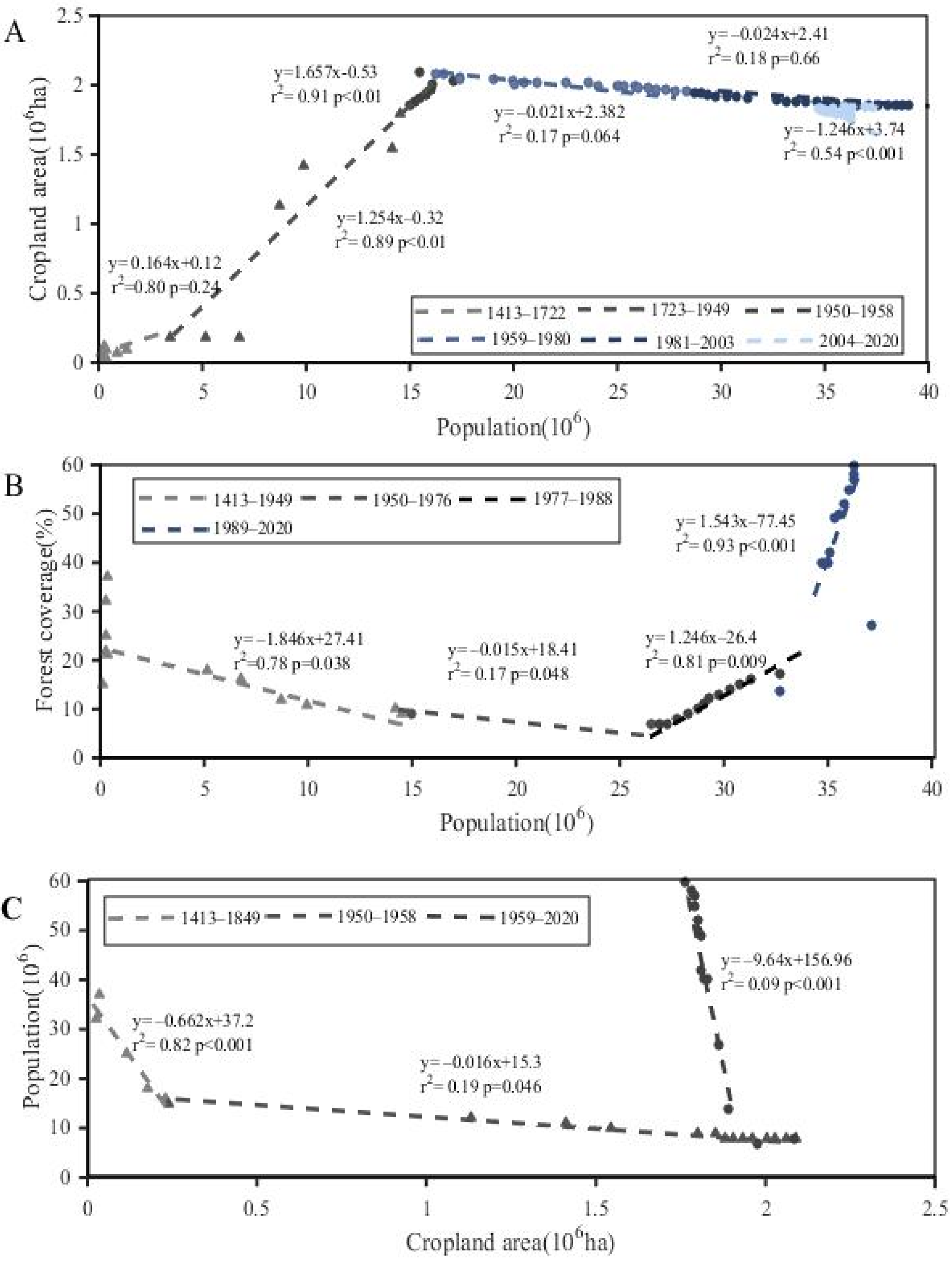
The turning points between two components of the social–ecological system were identified using piecewise linear regression, and are shown in Figure 4. The relationship between the population and cropland area went through six periods. (1) From 1413 to 1722, the relationship between the population and cropland area was not obvious, and the cropland area changed little as the population increased. (2) From 1723 to 1949, the population was positively correlated with the cropland area (p < 0.01), indicating that the cropland area increased with the increasing population. (3) From 1950 to 1958, there was still a positive correlation between the population and cropland area (p < 0.01), but the absolute slope was greater during this period than during the previous two periods. (4) The relationships between 1959 and 1980, and (5) between 1981 and 2003 were not obvious, and the cropland area changed little with the increasing population. (6) From 2004 to 2020, the relationship between the two was negatively correlated (p < 0.001), and the cropland area decreased with the increasing population.
The relationship between the population and forest coverage was divided into four periods. (1) From 1413 to 1949, there was a negative correlation between the population and forest coverage (p = 0.038), indicating that the forest coverage decreased with the increasing population. (2) The slope from 1950 to 1976 was smaller than that during the first phase. (3) From 1977 to 1988, the two were positively correlated (p = 0.009), and the forest coverage increased with the increasing population. (4) Between 1989 and 2020, there was still a positive correlation between to be population and forest coverage (p < 0.001), but the absolute slope was much larger during this period than during the previous period.
Over the entire time period, because of the competitive relationship between the cropland area and forest, there is a negative correlation between the cropland area and forest coverage. However, the slope of this relationship was different in different periods. The absolute value of the slope was higher during the third period (1959–2020) than during the first period (1413–1949), and the absolute value of the slope was the smallest during the second period (1950–1958).

3.3. Evolutionary Phases of the SES

According to the changes in the interactions between the social–ecological system’s components and the changes in the social–ecological system’s components in Guizhou Province in the last 600 years, this period was divided into six phases: 1413–1722, 1722–1949, 1949–1958, 1958–1980, 1980–2003, and 2003–present (Figure 5). It can be understood that two elements remain unchanged in the same period, and the other element changes to divide the phases.
The first phase (1413–1722) was the slow expansion of cultivation phase. During this period, the relationship between the population and the cropland area was not obvious, and the population was negatively correlated with the forest coverage. The cropland area was negatively correlated with the forest coverage. From 1413 to 1722, the population increased from 2.9 million to 1.363 million, the cropland area increased from 0.3 × 10⁶ ha to 0.46 × 10⁶ ha, and the forest coverage decreased from 39% to 17%.
The second phase (1722–1949) was characterized by the rapid expansion of cultivation. During this phase, the population was positively correlated with the cropland area and negatively correlated with the forest coverage. The cropland area was negatively correlated with the forest coverage. In 1949, the population was 14.509 million, the cropland area was 1.79 × 10⁶ ha, and the forest coverage was about 9%.
The third phase (1949–1958) was the continuous expansion of cultivation phase. During this phase, the population was positively correlated with the cropland area, and was negatively correlated with the forest coverage. The cropland area was negatively correlated with the forest coverage. In 1958, the population was 15.503 million, the cropland area was 2.092 × 10⁶ ha, and the forest coverage was about 8%.
The fourth phase (1958–1980) was the slower expansion of cultivation phase. During this phase, the relationship between the population and cropland area was not obvious, and the population was negatively correlated with the forest coverage. The cropland area was negatively correlated with the forest coverage. During this period, Guizhou experienced the Great Leap Forward (1958–1960), the Cultural Revolution (1966–1976), and the Great Famine (1959–1961). In 1980, the population was 28.298 million, the cropland area was still 1.95 × 10⁶ ha, and the forest coverage was about 9%.
The fifth phase (1980–2003) was the transformation of ecological protection driven by the returning farmland to forest phase. During this phase, the relationship between the population and cropland area was still not obvious, but the population and forest coverage were positively correlated. The cropland area and forest coverage were still negatively correlated. The population gradually increased to 39.37 million, the cropland area decreased to 1.85 × 10⁶ ha, and the forest coverage increased to about 33%.
The last phase (since 2003) was the green development driven by urbanization phase. During this phase, the population and cropland area were negatively correlated, but the population was still positively correlated with the forest coverage. The cropland area and forest coverage were negatively correlated. The population increased to 36.2295 million, the cropland area decreased to 1.76 × 10⁶ ha, and the forest coverage increased to about 60%.

3.4. Drivers of Changes in Social–Ecological Interactions

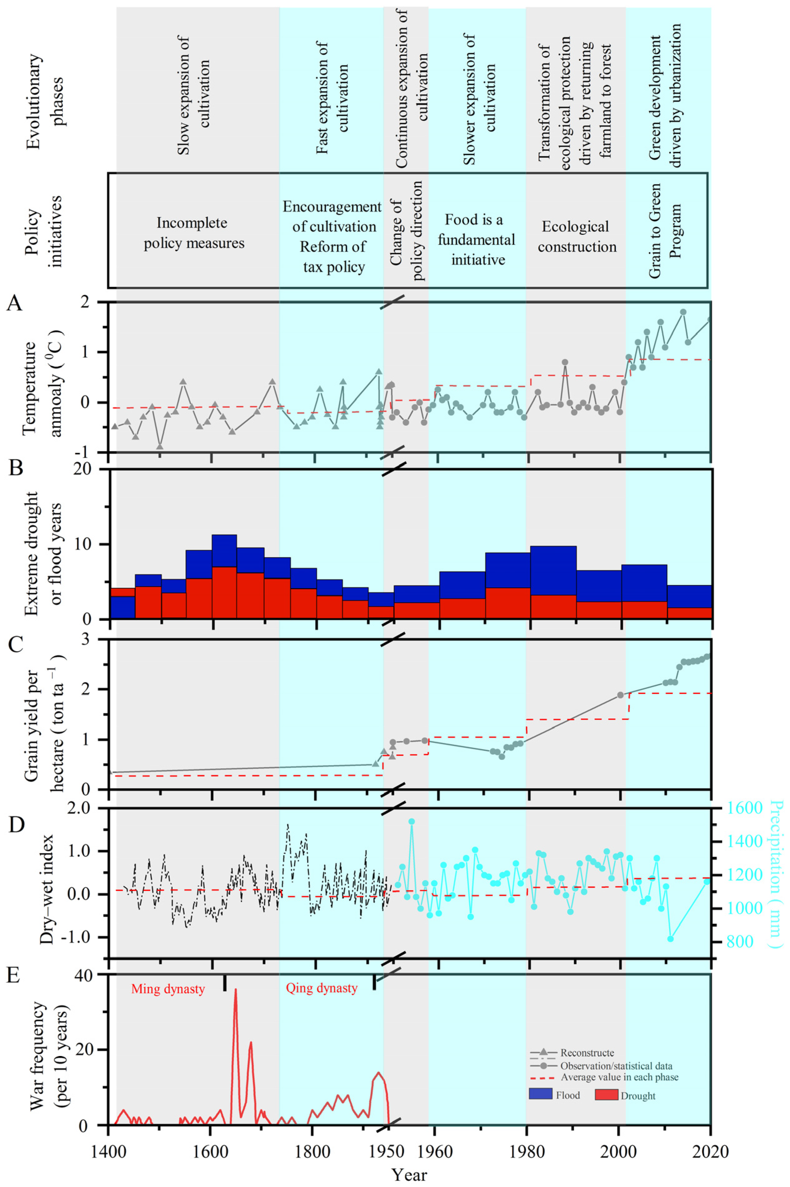
Figure 6 shows the policy, climate, socio-economic, and other driving factors that may affect the interactions between the components of the SES in Guizhou. These driving factors experienced significant changes during the different phases of the SES.
In ancient China (the first and second phases), the increase in the demand for food was mainly solved by increasing the area of arable land through reclamation [38,39]. For example, the Ming government increased the cropland area through immigration, army stationing, sending officials, reducing taxes, and other policies.
In the first phase, the slow expansion of cultivation was due to the development of Guizhou Province, which was not the intention of the Ming government, but the geographical location of Guizhou was of great significance to the military. Because the Ming government did not want to develop Guizhou, the immigration and garrison policies implemented in Guizhou were short in time and small in quantity, which did not have a good effect on increasing arable land. Additionally, during the Ming Dynasty, Guizhou’s geographical environment was very poor, and its infrastructure and living conditions were also poor. Officials dispatched by the Ming government were unwilling to go to Guizhou. Therefore, immigration, garrisons, and other policies in Guizhou were not very effective, which led to the slow expansion of cultivation. By the end of the Ming Dynasty and the beginning of the Qing Dynasty, Guizhou had experienced the Pingbo Incident in the Wanli Period, Kangxi Pingshui Xitusi, and the war between Kangxi and Wu Sangui. This political instability led to the slow development of agriculture.
The second stage, the rapid expansion of the scale of farming, was due to the Qing Dynasty in addition to reducing taxes, the encouragement of opening up wasteland, and most importantly, the reform measures in Guizhou reaching a climax in 1726 [40]. Subsequently, the comprehensive planting of opium and high-yield crops such as maize and potatos also increased the cropland area to some extent.
As a traditional agricultural society, in the first two phases, the population of Guizhou Province was sustained by agricultural production [41], and the agricultural production was affected by climate and extreme drought and flood events. Climate change and extreme events will directly or indirectly affect agricultural income, resulting in increased food prices and social instability, thus leading to war and population reduction [42]. Therefore, the increase in war and the decrease in population mainly occurred during time periods when the temperature decreased and serious droughts and floods occurred (Figure 3A and Figure 6). The decrease in population lead to a decrease in the cropland area, which explains the decrease in cropland area in Guizhou in the cold period in the 18th century (Figure 3 and Figure 6A).
In the third phase, the state put forward the grain-oriented slogan in the early days of the founding of the People’s Republic of China. The increase in the population during 1950–1958 resulted in an increase in the cultivation of slopes and the continued destruction of forests in Guizhou [43]. The development of agricultural techniques such as farmland engineering, chemical fertilizers and pesticides has increased agricultural productivity (Figure 6C), resulting in a further increase in the area of arable land.
In the fourth phase, although the population and cropland area both increased, under the influence of national policies and disasters, the absolute slope of their relationship during this period was smaller than that during the previous phase, and the forest coverage continued to decrease.
In the fifth phase, China’s economy rapidly developed after the reform and development, and the agricultural production mode changed from blindly increasing the area of cropland area to enhancing agricultural productivity and income transformation [44]. In this phase, ecological governance in Guizhou Province was mainly small regional governance. In the 1980s, due to the reality of Bijie’s fragile ecology, population expansion, and lagging development, a development poverty alleviation and ecological construction pilot area was established in Bijie, which represented the early practice of rocky desertification control in Guizhou. The improvement of the land use patterns and the use of chemical fertilizers, the increase of the use of agricultural machinery, and the increase in the irrigated area further improved agricultural productivity (Figure 6C) [45]. In addition, because family planning was formulated as a basic national policy in 1982, the population of Guizhou declined slightly.
After a series of floods and droughts in the 1990s, the national government paid more attention to the importance of national ecological security and sustainable development [46]. After this, ecological projects (e.g., returning farmland to forest and grassland) and soil and water conservation were implemented to restore vegetation in order to reduce the risk of natural disasters. In addition, the rocky desertification control mode changed from point to surface mode. This explains the increase in the slope of the positive correlation between the population and forest coverage during the sixth phase. Due to the development of ecological projects such as returning farmland to forest, economic development, industrialization, and urbanization have changed the livelihoods of farmers and reduced the land pressure to a certain extent. This explains the negative correlation between the cropland area and forest coverage.

3.5. Effects of Social–Ecological Interactions during Different Evolutionary Phases of the SES

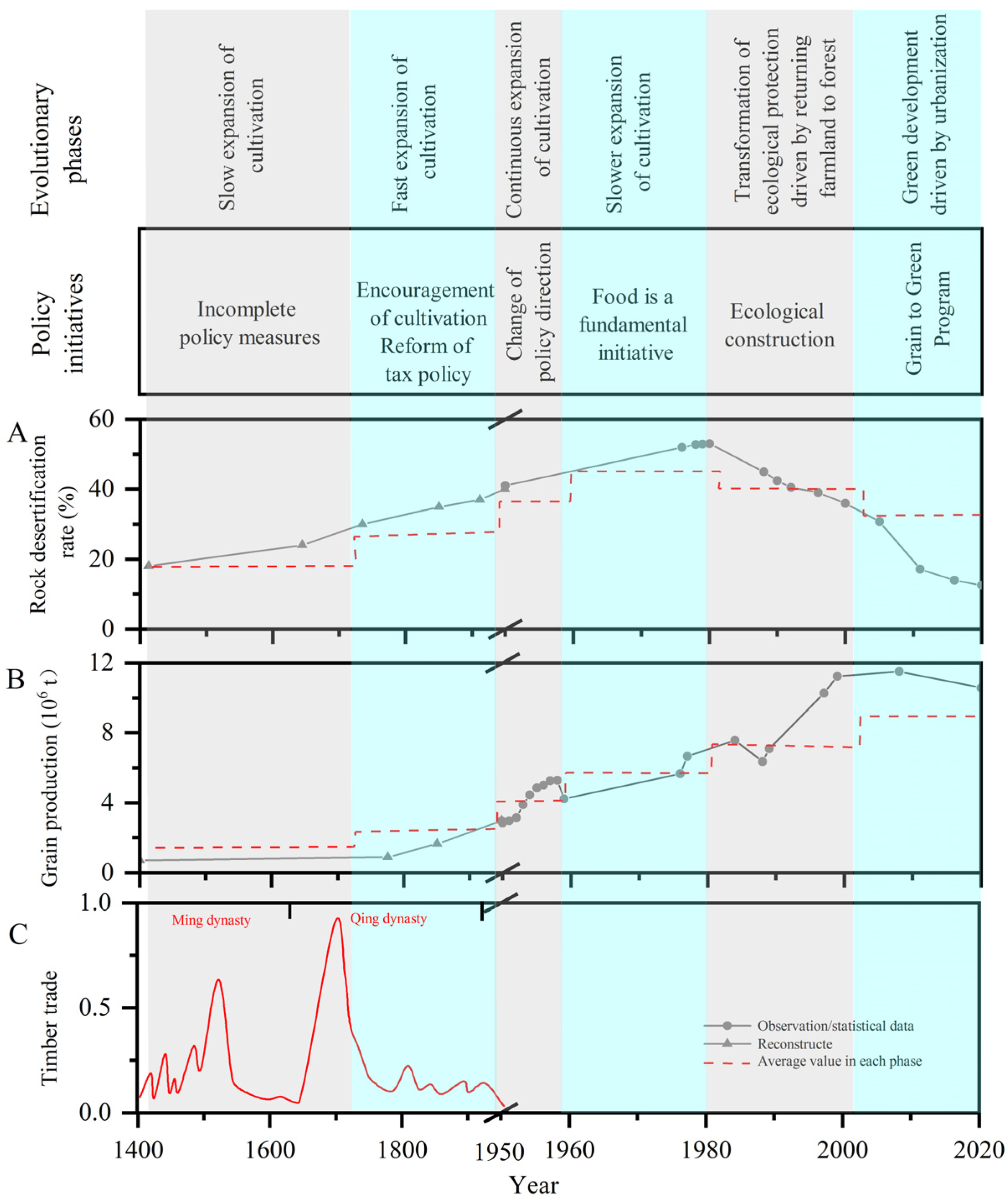
The influences of the interactions of the components of the social–ecological system in Guizhou have changed over time (Figure 7). By identifying different stages of social–ecological system evolution, we can better understand how the problems of the social ecosystem appear and are solved. In the first and second phases, there were a large number of original forests in Guizhou before the early Ming Dynasty, and the timber trade became the main means of economic development in Guizhou. At that time, in order to pursue economic development, people ignored the importance of the environment. Deforestation reached its climax in the Ming and Qing dynasties [46], and continuous deforestation caused serious rocky desertification (Figure 7A,C). Regarding the food problem caused by population growth, the continuous expansion of cultivated land, and continuous deforestation, although the grain production is increasing (Figure 7B), it is also in a vicious circle. It can be understood that the increasing timber trade is the impact of people’s blind pursuit of economy. Increasing food is the impact of people trying to solve the food demand. The increase in rocky desertification is aimed at the pursuing economies and addressing the combined effects of food.
In the third and fourth phases, after 1949, China prohibited the timber trade, and economic development was no longer the only objective in Guizhou Province. Because of the low productivity of our country at this time, solving the food demand was the main task. In the fifth and sixth phases, the landscape forest, field, lake and grass control project planned based on the system concept decreased the amount of soil erosion and the area of rocky desertification in Guizhou. By the sixth phase, the focus of policies had shifted to an ecologically oriented development model, and large-scale vegetation restoration further reduced the area of rocky desertification.

4. Discussion

The success or failure of environmental policies and management practices lies in whether the temporal and spatial changes in the interactions between the social and ecological components can be handled well [47]. This study provides a long time period perspective for understanding the evolution of social–ecological systems, which is different from the previous identification of steady-state transitions at mutation points in the time series of ecological or social components.
In this study, a method of identifying steady-state conversion based on changes in the interactions between the components of the social–ecological system was developed. By analyzing the changes in the relationships between the population, cropland area, and forest coverage, the evolutionary phases of the social–ecological system in Guizhou Province were divided into six phases: the slow expansion of cultivation, the rapid expansion of cultivation, the continuous expansion of cultivation, the slower expansion of cultivation, the transformation of ecological protection driven by returning farmland to forest, and green development driven by urbanization. The evolution stage identified in this study is basically consistent with the historical reality. In the process of stage change, some driving factors and local effects of interaction have changed significantly. Although the findings of this study are mainly from empirical research, they are still of great significance for future theoretical research. The framework proposed in this study may also shed light on social–ecological systems management and related research in other regions with a long history of development and human–land conflicts, such as the Amazon, Ganges and Yellow River basins.
In addition, the research framework links the phases of the social–ecological system with the driving factors and their effects, and provides guidance for the management of future social–ecological systems through the determination of the driving factors (e.g., policies and technology) needed to achieve the target state of the social–ecological system. The main lesson learned from the ecosystem management in Guizhou Province during the study period is not to focus on a single goal. In the first four phases, the management of the social–ecological system focused on food security, which damaged the ecological environment. Therefore, the management of the social–ecological system requires a comprehensive perspective, i.e., a change from focusing on a single goal to focusing on the interactions between components. From this perspective, the vicious cycle of more reclamation ⇨ overuse ⇨ poorer soil ⇨ more reclamation in the first four phases in Guizhou Province can be avoided. However, in the context of the enhanced impacts of human activities and global warming, how we should manage social–ecological systems requires further research. Due to the long time period of this study, the datasets used are highly dependent on the accuracy of the literature. Due to the omission and concealment of data, there may be errors and uncertainties in the historical archives, such as the rocky desertification area estimated from the literature during the historical period and the limited time resolution. Although there are some uncertainties, the trend of the index is basically credible.

5. Conclusions

The main focus of this study was the evolution of a social–ecological system over time. According to the social–ecological system steady-state transformation and social–ecological network, a research framework for the identification of the evolutionary phases of the social–ecological system according to the changes in the interactions between the system’s components was constructed. In addition, the driving factors and local effects were investigated. The feasibility of the framework was demonstrated through the evolution of the social–ecological system in Guizhou Province over the last 600 years.
Through integration of statistical survey data, historical reconstruction data, and relevant literature, the changes in the relationships among the population, cropland area, and forest coverage in Guizhou Province over the last 600 years were analyzed. The evolution of its social–ecological system was divided into six phases: the slow expansion of cultivation (1413–1722), the rapid expansion of cultivation (1722–1949), the continuous expansion of cultivation (1949–1958), the slower expansion of cultivation (1958–1980), the transformation of ecological protection driven by returning farmland to forest (1980–2003), and green development driven by urbanization (2003–present). In addition, the relationships between Guizhou’s social–ecological system and the policy, climate, socio-economic, and other driving factors, as well as their local effects, e.g., grain production, the rocky desertification area, and timber trade, were established. It was found that the pursuit of economic development and food production in the first four phases destroyed the ecological environment and exacerbated rocky desertification in Guizhou. In the last two phases, ecological restoration measures, such as returning farmland to forest and grassland, reduced the rocky desertification area in Guizhou. The case analysis of Guizhou Province shows that social–ecological system management needs to be considered from the perspective of the system and integration, and the relationships between the components should be considered instead of focusing on a single component.

Author Contributions

Y.Z. conceived the research idea. H.T. conducted field data collection and dissertation writing with. N.G. supervision dissertation. All authors have read and agreed to the published version of the manuscript.

Funding

This research was funded by [National Natural Science Foundation of China] grant number [41771115], the Major Research Issues on Comprehensively Deepening Reform in Guizhou Province (GZGGKT[2022]).

Institutional Review Board Statement

This study did not involve human or animals.

Informed Consent Statement

Informed consent was obtained from all subjects involved in the study.

Data Availability Statement

Not available.

Conflicts of Interest

The authors declare that they have no known competing financial interests or personal relationships that could have appeared to influence the work reported in this paper.

References

  1. Sachs, J.D. Sustainable development. Science 2004, 304, 649. [Google Scholar] [CrossRef] [Green Version]
  2. Griggs, D.; Stafford-Smith, M.; Gaffney, O. Sustainable development goals for people and planet. Nature 2013, 495, 305–307. [Google Scholar] [CrossRef]
  3. Levin, S.; Xepapadeas, T. Social-ecological systems as complex adaptive systems: Modeling and policy implications. Environ. Dev. Econ. 2013, 18, 111–132. [Google Scholar] [CrossRef] [Green Version]
  4. Hallie, E.; Amy, L.L. Assessing the vulnerability of social-environmental systems. Annu. Rev. Environ. Resour. 2006, 31, 365–394. [Google Scholar]
  5. Glaser, M.; Krause, G.; Ratter, B. Human/Nature interaction in the anthropocene potential of social-ecological systems analysis. Gaia 2008, 17, 77–80. [Google Scholar] [CrossRef]
  6. Timothy, K.; Art, D.; Julian, C. Advancing adaptive governance of social-ecological systems through theoretical multiplicity. Environ. Sci. Policy 2016, 57, 1–9. [Google Scholar]
  7. Beyers, B.; Folke, C. Socia-ecological systems insights for navigating the dynamics of the anthropocene. Annu. Rev. Env. Resour. 2018, 43, 267–289. [Google Scholar]
  8. Berkes, F.; Seixas, C.S. Building resilience in lagoon social-ecological systems: A local-level perspective. Ecosystems 2005, 8, 967–974. [Google Scholar] [CrossRef] [Green Version]
  9. Todorov, V.; Dimov, I.; Ostromsky, T.; Apostolov, S.; Georgieva, R.; Dimitrov, Y.; Zlatev, Z. Advanced stochastic approaches for Sobol’ sensitivity indices evaluation. Neural Comput. Appl. 2021, 33, 1999–2014. [Google Scholar] [CrossRef]
  10. Dimov, I.; Todorov, V.; Sabelfeld, K. A study of highly efficient stochastic sequences for multidimensional sensitivity analysis. Monte Carlo Methods Appl. 2022, 28, 1–12. [Google Scholar] [CrossRef]
  11. Vitousek, P.M.; Mooney, H.A.; Lubchenco, J. Human domination of earth’s ecosystems. Science 1997, 277, 494–499. [Google Scholar] [CrossRef] [Green Version]
  12. Wang, S.; Fu, B.J.; Wu, X.T. Dynamics and sustainability of social-ecological systems in the Loess Plateau. Resour. Sci. 2020, 42, 96–103. [Google Scholar] [CrossRef]
  13. Todorov, V.; Dimov, I.; Ostromsky, T.; Zlatev, Z.; Georgieva, R.; Poryazov, S. Optimized Quasi-Monte Carlo Methods Based on Vander Corput Sequence for Sensitivity Analysis in Air Pollution Modelling. In Recent Advances in Computational Optimization; Springer: Cham, Switzerland, 2021; pp. 389–405. [Google Scholar]
  14. Fidanova, S. Recent Advances in Computational Optimization, 1st ed.; Springer: Cham, Switzerland, 2020; p. 986. [Google Scholar]
  15. Dimov, I.; Maire, S.; Todorov, V. An unbiased Monte Carlo method to solve linear Volterra equations of the second kind. Neural Comput. Appl. 2022, 34, 1527–1540. [Google Scholar] [CrossRef]
  16. Ostrom, E. A general framework for analyzing sustainability of social-ecological systems. Science 2009, 325, 419–422. [Google Scholar] [CrossRef]
  17. Xiong, K.N.; Li, J.; Long, M.Z. Features of soil and water loss and key issues in demonstration areas for combating karst rocky desertification. Acta Geogr. Sin. 2012, 67, 878–888. [Google Scholar]
  18. Zhao, C.W.; Pu, L.J. Relationship between the arable land change and the grain production in Guizhou province during the past 50 years. J. Nanjing Univ. Nat. Sci. 2005, 1, 105–112. [Google Scholar]
  19. Gao, H.J.; Han, H.Q.; Liu, R. Changes in landscape disturbance degree of steep slope land use in Guizhou Province from 1995 to 2015. J. Nanjing For. Univ. Nat. Sci. Ed. 2020, 44, 183–190. [Google Scholar]
  20. Jiang, M.; Lin, Y.; Chan, T.O.; Yao, Y.J.; Zheng, G. Geologic factors leadingly drawing the macroecological pattern of rocky desertification in southwest China. Sci. Rep. 2020, 10, 1440. [Google Scholar] [CrossRef]
  21. Zhang, Z.; Ouyang, Z.Y.; Xiao, Y. Using principal component analysis and annual seasonal trend analysis to assess karst rocky desertification in southwestern China. Environ. Monit. Assess. 2017, 189, 269. [Google Scholar] [CrossRef]
  22. Malash, G.F.; El-Khaiary, M.I. Piecewise linear regression: A statistical method for the analysis of experimental adsorption data by the intraparticle-diffusion models. Chem. Eng. J. 2010, 163, 256–263. [Google Scholar] [CrossRef]
  23. Arthur, B.; Gerard, V.D.; Martine, D.V. The HYDE 3.1 spatially explicit database of human-induced global land-use change over the past 12,000 years. Glob. Ecol. Biogeogr. 2011, 20, 73–86. [Google Scholar]
  24. Li, Y.; Piao, S. Divergent hydrological response to large-scale afforestation and vegetation greening in China. Sci. Adv. 2018, 4, 41182. [Google Scholar] [CrossRef] [Green Version]
  25. Zhang, X. On the systems of tusi and native official and the change of making native official into uniform official system. China’s Borderl. Hist. Geogr. Stud. 2005, 2, 78–84. [Google Scholar]
  26. Jiang, D.X. On the immigration of Guizhou in Qing dynasty. Popul. Res. 1983, 5, 35–40. [Google Scholar]
  27. Liu, M.L.; Tian, H.Q. China’s land cover and land use change from 1700 to 2005: Estimations from high-resolution satellite data and historical archives. Glob. Biogeochem. Cycles 2010, 24, 138. [Google Scholar] [CrossRef]
  28. Ge, Q.S.; Dai, J.H.; He, F.N. Analysis on the quantity change and driving factors of cultivated land resources in some provinces of China in the past 300 years. Sci Adv. 2003, 8, 50–116. [Google Scholar]
  29. Perkins, D.H. Agricultural Development in China; Taylor and Francis: New York, NY, USA, 2017; pp. 1368–1968. [Google Scholar]
  30. Si, N.H. Study on forest change in historical period. J. Chin. Hist. Geogr. 1988, 1, S1–S17. [Google Scholar]
  31. He, F.; Ge, Q.; Dai, J.; Rao, Y. Forest change of China in recent 300 years. J. Geogr. Sci. 2008, 18, 59–72. [Google Scholar] [CrossRef]
  32. Ge, Q.S.; Liu, H.L.; Zheng, J.Y. The climate change and social development over the last two millennia in china. Chin. J. Nat. 2013, 35, 9–21. [Google Scholar]
  33. Zhang, D.D.; Jim, C.Y.; Lin, G.; He, Y.Q.; Wang, J.J.; Lee, H.F. Climatic change, wars and dynastic cycles in China over the last millennium. Clim. Chang. 2006, 76, 459–477. [Google Scholar] [CrossRef]
  34. Wu, W.H. Analysis and trend prediction of drought and flood in Guizhou in 500 years. Mid Low Latit. Mt. Meteorol. 1999, 3, 15–20. [Google Scholar]
  35. Shen, W.J. Study on Forestry Economy and Social Change in Qingshui River Basin (1644–1911), 1st ed.; Beijing Forestry University: Beijing, China, 2006; pp. 6–28. [Google Scholar]
  36. Zhang, Y.Y. A Preliminary Study on the Distribution of Rocky Desertification and Its Human Causes in Guizhou in the Qing Dynasty; Fuh Tan University: Shanghai, China, 2010. [Google Scholar]
  37. Yang, Y.D.; Chen, J.S.; Qing, R.X. Comparative analysis of data processing based on subjective evaluation method. Min. Saf. Environ. Prot. 2008, 4, 63–68. [Google Scholar]
  38. Ge, Q.; Dai, J.; He, F.; Zheng, J.; Man, Z.; Zhao, Y. Spatiotemporal dynamics of reclamation and cultivation and its driving factors in parts of china during the last three centuries. Prog. Nat. Sci. 2004, 14, 605–613. [Google Scholar] [CrossRef]
  39. Han, Z.Q. The decision-making process, causes and influence of Yongzheng’s development of Guizhou. Fudan J. Soc. Sci. Ed. 2010, 2, 301–314. [Google Scholar]
  40. Zhang, D.; Jim, C.; Lin, C.; He, Y.; Lee, F. Climate change, social unrest and dynastic transition in ancient China. Chin. Sci. Bull. 2000, 55, 137–144. [Google Scholar] [CrossRef]
  41. Zhang, D.D.; Brecke, P.; Lee, H.F.; He, Y.Q.; Zhang, J. Global climate change, war, and population decline in recent human history. Proc. Natl. Acad. Sci. USA 2007, 104, 19214–19219. [Google Scholar] [CrossRef] [Green Version]
  42. Lou, G.; Wang, S.J.; Li, Y.B. Spatio-temporal dynamics and ecological service function assessment of slope farmland in Karst areas of Guizhou province, China. Trans. Chin. Soc. Agric. Eng. 2014, 30, 233–243. [Google Scholar]
  43. Wu, G.Y.; Wang, X.F.; Lei, R.Y. Evaluation of regional sustainable development capacity of agriculture in China—A case study of southwest China. J. Anhui Agric. Sci. 2004, 3, 580–602. [Google Scholar]
  44. Li, R.L.; Wang, S.J. Comprehensive Evaluation of Regional Agricultural Ecological Environment in Guizhou. Carsologica Sin. 2001, 3, 59–64. [Google Scholar]
  45. Bryan, B.A.; Gao, L.; Ye, Y.; Sun, X.; Connor, J.D.; Crossman, N.D.; Hou, X. China’s response to a national land-system sustainability emergency. Nature 2018, 559, 193–204. [Google Scholar] [CrossRef]
  46. Lin, Q. Study on forestry production and wood trade in Qingshui River Basin in Ming and Qing Dynasties. J. Guizhou Univ. Art Ed. 2016, 34, 31–99. [Google Scholar]
  47. Liu, J.; Dietz, T.; Carpenter, S.R.; Folke, C.; Alberti, M.; Redman, C.L.; Provencher, W. Coupled human and natural systems. Ambio 2007, 36, 639–649. [Google Scholar] [CrossRef]
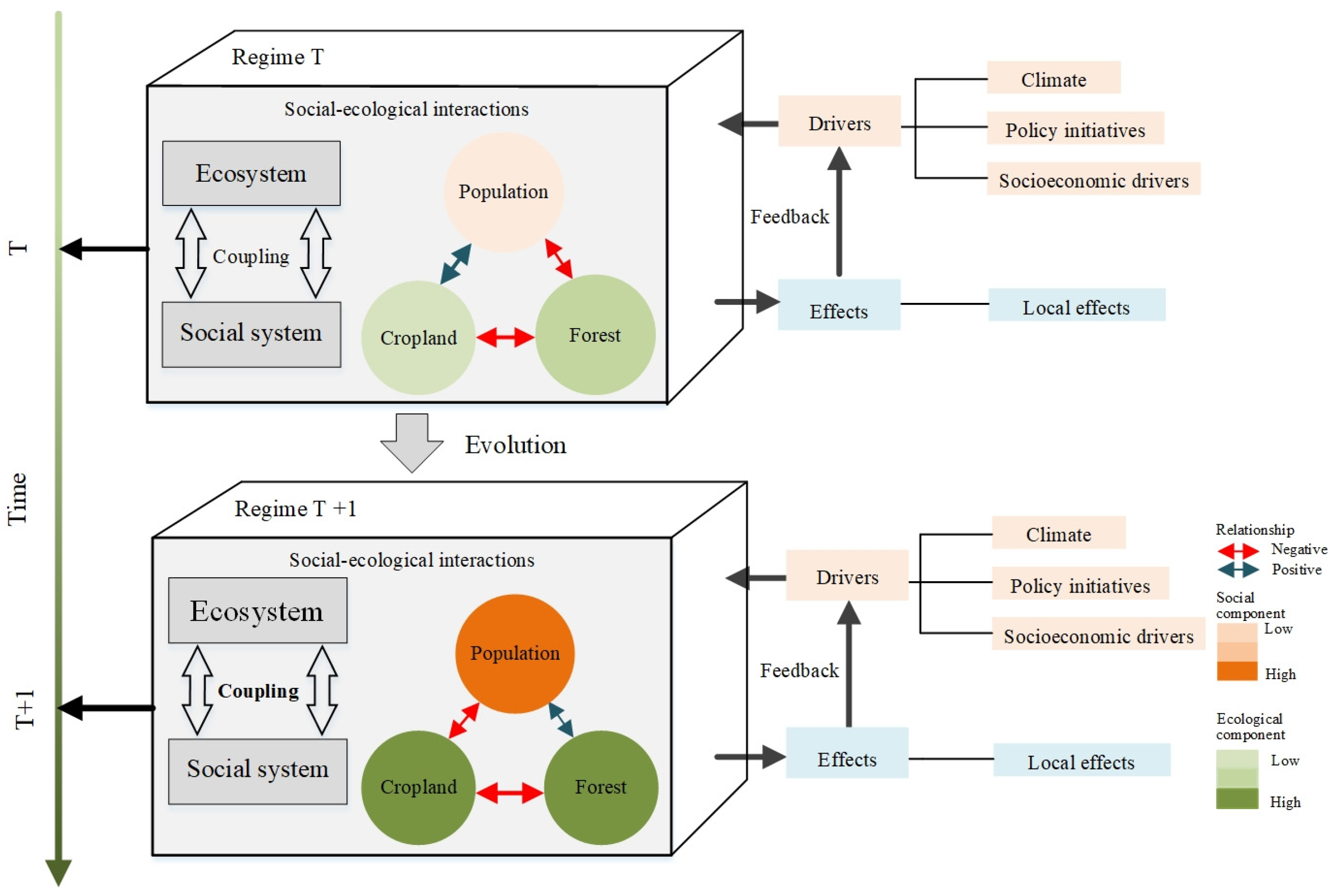
Figure 1. A framework for understanding the evolution of the SES in Guizhou Province. The double-sided arrows represent the interactions between the system’s components. The transition of any relationship from positive to negative, or vice versa, represents a shift in the SES from one evolutionary phase to another.
Sustainability 14 07688 g001
Figure 2. Map showing the location of the study area.
Sustainability 14 07688 g002
Figure 3. Changes in the system’s component indicators over the last 600 years: (A) population, (B) cropland area, and (C) forest coverage.
Sustainability 14 07688 g003
Figure 4. Changes in the interactions between the system’s components and the evolutionary phases of the SES in Guizhou Province. (A) Relationship between the population and cropland area. (B) Relationship between the population and forest coverage. (C) Relationship between the cropland area and forest coverage.
Sustainability 14 07688 g004
Figure 5. Evolutionary phases of the SES in Guizhou Province.
Sustainability 14 07688 g005
Figure 6. The driving factors of the changes in the interactions of the components of the SES in Guizhou Province: (A) temperature anomalies; (B) extreme drought and flood years; (C) grain yield per hectare; (D) proxy precipitation index and precipitation; and (E) war frequency. The data come from ancient books; please see Section 2.2 for details.
Sustainability 14 07688 g006
Figure 7. The effect of the interactions between the components of the SES in Guizhou Province during the different evolutionary phases: (A) the rocky desertification rate, (B) grain production, and (C) the timber trade. The data come from ancient books; please see Section 2.2 for details.
Sustainability 14 07688 g007
Table 1. Information about the historical datasets.
OrderDatasetTypeTime SpanTemporal
Resolution
Spatial RangeOriginal MaterialCredibilityData
Source
1PopulationHistorical
records
1400–1949-Guizhou ProvinceHousehold
registration
information
Population is conservatively estimated but reflects the overall trend. More data for the most recent 200 years.Chroni
cles
2Cropland
area
Historical
records
1400–1949-Guizhou ProvinceOfficial government
publications and local chronicles authorized by the government
Reflects the overall trend. More data
for the most
recent 300 years.
[26,27,28]
3Forest
coverage
Inferred
data
1400–1949-Guizhou ProvinceEstimated based on
Chinese historical
documents
Reflects the overall trend. More data
for the most
recent 200 years.
[29,30,31]
4 Temperature anomaliesReconstru
cted data
1400–194930 yearsSubtropical Northern Hemisphere (including Guizhou Province)Phenological
cold/warm events
recorded in Chinese
historical documents
Errors range from ±0.7 °C to ±1.5 °C during the reconstruction; highly
consistent with other reconstruction data
for the most recent 500 years.
[32,33,34]
5Dry–wet index Reconstru
cted data
1400–194910 yearsEastern China Monsoon Region (including Guizhou Province)Chinese historical
documents and
instrument
measurements
The correlation coefficient of the reconstructed precipitation in Guizhou Province from 1920 to 1949 is 0.66. Can be used to reflect changes in precipitation[32,33,34]
6Extreme Drought and Flood EventsHistorical
records
1400–194950 yearsEastern China Monsoon Region (including Guizhou Province)Annual drought/flood
grades derived from
historical archives
High data credibility[35]
7Grain yield per hectare Inferred
data
1400, 1776, 1851,-Guizhou ProvinceEstimated based on
population and
cropland area
Temporal coverage is poor, but the data
reflect the overall trend.
[29]
8War frequency Historical
records
1400–194410 yearsGuizhou ProvinceChronology of wars in ChinaOnly the reliable variables were used to
calculate the frequency-of-war time
series.
[34]
9Rock desertification rateInferred
data
--Guizhou ProvinceEstimated based on
Chinese historical
atlas
Temporal coverage is poor, but the data are
relatively reliable.
[36]
10Grain
production
Inferred
data
1400–1949-Guizhou ProvinceEstimated based on
cropland area and
grain yield per unit
area
Temporal coverage is poor, but the data
reflect the overall trend.
-
11Timber trade Inferred
data
1400–1948-Guizhou ProvinceEstimated based on
Chinese historical
atlas
Temporal coverage is poor, but the data are
relatively reliable.
[37]
Table 2. Information about the datasets after 1949.
Order.Dataset Data Source
1Population Guizhou Provincial Bureau of Statistics
2Cropland area (ha) Guizhou Provincial Bureau of Statistics
3Temperature (°C) Guizhou Meteorological Bureau
4Precipitation (mm) Guizhou Meteorological Bureau
5Forest coverage (%) National forest resource surveys
6Extreme Drought and Flood Events [35]
7Grain yield per hectare (ton ha−1) Derived from the grain production and cropland area
8Grain production (ton) Guizhou Provincial Bureau of Statistics
9Rock desertification rate (%) Ministry of Natural Resources of the People’s Republic of China
Publisher’s Note: MDPI stays neutral with regard to jurisdictional claims in published maps and institutional affiliations.