Article

Local Spatial Plans in Supporting Sustainable Water Resources Management: Case Study from Warsaw Agglomeration—Kampinos National Park Vicinity

by
Krystyna Solarek
* and
Marta Kubasińska
Faculty of Architecture, Warsaw University of Technology, Koszykowa 55, 00-659 Warsaw, Poland
*
Author to whom correspondence should be addressed.
Sustainability 2022, 14(10), 5766; https://doi.org/10.3390/su14105766
Submission received: 4 April 2022 / Revised: 29 April 2022 / Accepted: 7 May 2022 / Published: 10 May 2022
(This article belongs to the Special Issue Water Resources Governance for a Sustainable Future)

Abstract

:
The crisis resulting from progressive climate change is reflected in increasingly violent problems with periodic excesses and shortages of water. Integrated water management has thus become a necessity and it depends, inter alia, on the effectiveness of the adopted strategies, policies and individual investments. In many countries, including Poland, the implementation of this postulate is slow. The importance of local spatial plans, which are a tool that directly translates adopted policies into spatial development, is underestimated. The article presents studies of the provisions of planning documents with particular emphasis on the local spatial plans regulations in terms of considering the issue of water management. Some municipalities in the Warsaw agglomeration were selected for the detailed research, as the areas characterized by various water conditions. Local spatial plans adopted for this territory were compared to model planning acts from other regions of Europe. The conclusions include recommendations for local spatial plans and a method for assessing planning documents regarding the scope of the sustainable water management arrangements. The study results indicate that the principles of integrated water management have not been fully incorporated into the existing plans in Poland and that national and regional policies are poorly translated into real management planning.

1. Introduction

Water resources are a component of the environment that directly and inescapably reflects the significant impact of climate change on human life and health and the functioning of ecosystems [1,2]. Climate change, along with the increase in population and the level of urbanization, significantly affects the probability of more frequent and more intense extreme events and crises—including the burden on water resources and the risk of droughts and floods [3,4,5].
Climate, freshwater and biophysical and socioeconomic systems interrelate in a complex way, therefore a change in any of them can bring about a change in another. Freshwater issues are crucial to defining local, regional, and sectoral policies [6]. Anthropogenic climate change affects water resources and water demand, including irrigation water [7]. Many researchers are extending previous global water research by analyzing the impact of climate and population change on this environmental factor and the effect of income, electricity production, water efficiency and other driving forces on water scarcity [8].
An approach that promotes the coordinated development and management of water, land, and related resources to maximize the resulting economic and social well-being equitably, without compromising the sustainability of essential ecosystems, is part of the concept of Integrated Water Resource Management (IWRM). This approach has been adopted to ensure equitable, economic and environmentally sustainable water resource management and water service provision [9]. The current impacts and future anticipated risks associated with extreme events demand sustainable solutions for climate change adaptation (CCA) and disaster risk reduction (DRR) [10]. As flood risk management must be carried out from the perspective of Integrated Water Resource Management [11], broadly speaking, the authors will focus on integrated water resources and flood risk management, in short—integrated water management.
Worldwide, more and more integrated water management instruments are being used. Reports and studies show that many are still in the early stages of implementation, and this applies to many different countries. There is a clear need to support any action to improve the situation by acting on the ground, tracking legislative changes and the promotion of good practice [12]. Implementing resilient strategies faces many difficulties also in Poland [13]. Policies at different levels of planning are not sufficiently integrated. The role of inter-communal spatial planning and programming of integrated actions, i.e., joint adoption of appropriate planning provisions and elements carrying out mutually agreed-upon investments by various stakeholders, is not sufficiently examined. Above all, however, it is crucial how the IWRM and flood risk management policy is implemented at the local level. Assuming that local spatial plans are one of the most important instruments of spatial policy implementation [14,15,16], attention should be paid to what provisions supporting sustainable water management are used in such documents.
The literature points to many weaknesses of the spatial management system and even goes further, seeing difficulties or even an inability to translate planning theory into reality [17,18]. This is especially noticeable and even severe in countries with weak planning systems facing rapid urbanization. Weak planning systems are understood to be inadequate to assist in the development and implementation of spatial plans and policies such as rigid land use plans. They are systems that favor spatial development plans, that are detached from the processes taking place in the territory, society and political discourse [19]. These systems are so liberal or unintegrated that in fact they lead to “planned chaos” [20]. Among other places, in Poland, the key problem is the lack of effective shaping and protection of the spatial order with the help of the available tools of spatial policy [20,21,22,23,24,25,26].
This does not mean, however, that the issue of the quality and effectiveness of local plans can be ignored, the more so as they can have a significant impact on the natural environment, water resources, safety and the quality of life of the inhabitants. Sometimes, because of the adoption of inappropriate local plans, it is possible to irretrievably destroy the potential and quality of water resources or contribute to increasing the risk of flooding. And vice versa, thanks to “good plans”, water resources can be protected, and by increasing retention, even improve the conditions for the functioning of the built environment. The need for integrated planning is being more and more clearly articulated—the issue of integrated development planning is addressed in a diverse range of forums as it can be a key to an efficient spatial management system [27,28]. Environmental issues, including water management, should be part of this [29].
In the current scientific literature, we have not found information about conducting research on the content of local spatial development plans in relation to the issues of sustainable water management. Admittedly, scientific papers on broadly understood integrated water management in city planning have a rich literature, and the relationship between water management and land development is discussed in many publications [30,31,32]. The authors of such papers focus on applying integrated water systems management at different planning and design levels using various tools, but they do not relate to specific planning policy tools, such as local development plans. Most often, where reporting on the topics of water management, the concept of solutions using green and blue infrastructure is recommended as traditional methods and grey infrastructure do not always prevent unfavorable, intensifying hydrological phenomena [33,34,35,36,37]. There is also extensive literature on the relationship between spatial planning and flood-risk management, although also not in the context of the local spatial plans. For example, Ran & Nedovic-Budic [38] analyzes the dimensions of integration of spatial planning with flood-risk management. Cilliers [39] focuses on land use conflicts related to planning in flood risk areas. Numerous publications are devoted to tools supporting spatial planning in areas at risk of flooding and tools for collecting information about phenomena and problems occurring there. This largely applies to geoinformation tools and tools supporting decision making in planning, using technological advances in GIS and remote sensing [40,41,42,43] or to the plan implementation [44]. Generally, spatial planning is increasingly regarded as one of the important instruments in disaster risk reduction [45,46,47].
Urban planning can face many of the overall challenges of mainstreaming risk reduction into development planning. However, it faces many barriers. One of them is the lack, or weakness of developed planning tools at the local level, which should be changed and improved for better water management. This article proposes the use of tools for assessing the content of the provisions [also referred to as “regulations” in this article] of local spatial development plans in order to achieve this change.
Various types of evaluation exercises are performed during the planning processes, albeit to an insufficient degree and usually to a limited extent. Three types of such evaluation can be distinguished: ex-ante methods, assuming the effects of plans in advance, ex-post methods, and the most commonly used on-going methods [48]. Evaluation in spatial planning focusses mainly on the model proposed by Alexander: policy-plan/program-implementation-process [49,50].
In this research, the authors do not assess the broadly understood quality of local plans or the impact of their decisions on the environment, in particular on issues related to water management. Such assessments as environmental impact assessment and other forecasts of the impact on the broadly understood environment with different names, for example: Sustainability Appraisal Report or Local Plan Viability Assessment, are carried out in parallel with the planning procedure. A comprehensive assessment of the quality of local development plans would require checking their entire procedure, the extent of stakeholder involvement, collected input materials and maps, supporting decision-making tools, and compliance with policies at all levels of spatial management, as well as with state law. By Kim and Li, quality plans include vision; identification of objectives and goals; incorporation of results from the response to public engagement’s response; assessments of current and future conditions; prioritization of development proposals, investment, and policy changes; and an agenda for evaluating the implementation [51,52,53,54,55,56]. However, there is no study of what concerns the legal provisions of local spatial development plans.
As there is limited understanding of how local governments can formulate spatial development plans to implement integrated water management planning in practice, this study seems to be important. Recognizing that the local spatial development plan is one of the most important tools of spatial policy [14,15], selected of such plans were examined in terms of their provisions relating to integrated water management. We have paid special attention to the provisions concerning rainwater management and flood protection.
The fundamental importance of a local plan as a tool for the development of a functional and spatial structure that will be conducive to integrated water management consists primarily in designing a spatial structure adapted to the natural conditions of the area covered by this plan. Many of the principles of land development are communicated by the map, and they are not disclosed in the text of the plan at all. They are “implemented” through appropriately designed and described spatial structures (especially of a network nature), including the layout of areas intended for development, excluded from development, active infiltration, including green infrastructure. And yet, individual and public investments are implemented with the use of textual regulations, and only in this part of the local plan is it possible to introduce such development rules that will be conducive to sustainable water management. Regulations of local plans, which are the main subject of this study, can be implemented only if they can be formulated in the form of land development rules, which can then be “transferred” to building permits. Although local planning differs in individual jurisdictions of European countries, the direct translation of planning regulations at the local level everywhere translates more or less directly into the investment process [14,15]. And these are the regulations that are being studied here.
The aim of the article is to assess the content of local spatial development plans in a selected research area in terms of their suitability for supporting water management and to present a proposal for a method of such an assessment. The conducted analysis has its limitations, resulting from focusing on the provisions of the text part of the plan.

2. Materials and Methods

2.1. Methodology

This study examined whether and to what extent the key water management principles were incorporated into exemplary local spatial plans by applying quality assessment of the textual part of the plans. The outline of the research workflow is shown on the Figure 1.
The first part of the mainstream research involved selecting the site for detailed study. The premise was that the case study area should be characterized by a variety of issues related to water management, and at the same time that it should be subject to urbanization processes. We have briefly described this location and presented it on maps.
Then we established a checklist for the plans subjected to detailed analysis assessment. To check what questions should be included on the checklist, so that they best correspond to the specifics of the local plan and translate as best as possible into investments on the ground, it was not enough to refer to the scientific literature [32,33,34,35,36,37,38,39,40,41,42,43,44,45], nor well-known postulates for IWRM. To assess the extent of the occurrence of various regulations concerning water management, it was necessary to determine what they could and should be in local plans. It was important for us to refer to the adopted plans that could be considered as reference due to the wealth of water management arrangements.
For this purpose, two reference local plans were examined. It was assumed that these should be plans prepared in recent years for new investment areas with major hydrological problems. Plans were selected from two regions of Europe—from Copenhagen in Denmark, where the problem of water management has been solved very well and planning standards are high, and from Warsaw in Poland, which has the ambition to address water management challenges in the best possible way. One of the plans selected is the plan for the Orestadt area in Copenhagen, the other is the local plan for the South Czerniaków district in Warsaw.
The formal provisions included in these two model plans were thoroughly analyzed and on this basis a set of questions was prepared that could concern other European, including Polish local plans. The set developed in this way became the basis for the formation of a checklist, against which the individual examined plans were later assessed.
The main part of the research was the analysis and assessment of the planning documents in the selected area. In the area of the study, various types of planning documents are in force in a different scope: (1) national plan and (2) regional plan, both applying to the entire studied area; (3) general plans for individual 11 communes in the studied area and (4) local plans of various numbers and sizes in each commune.
Firstly, we checked which guidelines for local spatial policy in the field of water management are provided by the national and regional studies. As all communes are in the Mazowieckie Voivodeship, the spatial development plan of this voivodeship was analyzed, as this document can most fully translate into further activities in the field of spatial planning and management in the voivodeship.
Next, the documents that define the local spatial policy of communes were examined; these are the so-called “studies of the conditions and directions of spatial development”, hereinafter referred to as general plans or comprehensive plans. They are always compulsory and cover the area of the entire commune. These are not generally binding legal acts, but rather acts of internal management and all local spatial development plans must comply with their guidelines. General plans of all communes in the area of the study were analyzed, i.e., 11 documents. They were adopted in different years, the oldest of these plans being adopted in 2008, and the newest in 2021. In all of the above-mentioned plans, records were searched for relating to water management and protection against the effects of floods.
All of these general plans were assessed according to the methodology recommended in the United Nations publication, devoted to the values-based approach to urban planning, concentrated on climate change [57]. When assessing some environmental aspects in spatial development plans, it is considered advisable to introduce the so-called constructed scale, in which qualitative descriptions are used to assess the degree of goal achievement. Each level of the scale is described, not measured, so they can be called descriptive indicators.
The analysis of the general plans, confirmed by the practical experience of the authors of the research, allowed for such descriptions. The level of subjectivity of the assessment, although allowed in this method, was low here, because the assessment was made based on answers to two questions: 1. Did the planned directions of the spatial development of the commune, shown in the general plan, indicate the necessity to take into account the problems of water and sewage management when drawing up management plans? 2. Were these findings addressing several water management issues and were they mutually consistent? According to the answer: yes or no, the grades of the plan were assigned: bad, medium or good (Figure 2). In the illustrations of the results, these grades were also assigned colors (bad in red, medium in yellow, good in green).
As a result, three groups of general plans were distinguished: 1. not taking into account the subject of water (bad), 2. taking into account the subject matter but insufficiently (medium), and 3. properly taking into account the subject of water (good). The results of the detailed research carried out in the next step were finally confronted with this assessment.
The next step was the assessment of the provisions of the chosen local spatial plans. The following steps were used for the sampling process. First, three principles for the research procedure were formulated: (1) it is necessary to examine chosen local plans in all 11 communes to know, how they are formulated in each of the local government, (2) plans prepared for very small areas should be excluded from the analysis, because they do not reflect the approach to comprehensive settlement of water issues, (3) the plans should cover the largest possible areas, but at the same time those where water problems are most noticeable.
The source of these assumptions was the knowledge about the problems in the field of water and space management in the selected research area, resulting from the analyzed conditions [58,59,60,61,62,63] and the knowledge of the spatial planning system in Poland with its weaknesses [20,21,22,23,24,64]. So, it resulted both from the authors’ own research and from the studied scientific literature, cited above, and the confirmation of these assumptions is as follows:
Ad 1. As the water problems of the research area are complex, interrelated and there are components that make up the entire water system in all communes, we considered checking the plans for all communes (i.e., 11) to be justified.
Ad 2. The decision to exclude local spatial plans for very small areas from the analyzes is justified by the fact that they do not reflect the approach to comprehensive settlement of water issues. The preparation of such individual, out-of-context plans is criticized in Poland, although it happens often. These are plans for an area of one acre to several hectares.
Ad 3. The selection of local spatial plans for the analysis was guided by the size of the area covered by the given plan and the location in a particularly sensitive area for water management problems. Attempts were made to select plans for the largest areas of land, thus having the strongest impact on local spatial development, that is, with an average area of: 1.50–6.00 km2. In a few cases, smaller plans were selected (0.30–1.00 km2), but ones that were enacted for areas with particular water problems.
In order to facilitate comparisons of the approach to shaping planning texts, it was decided to select an equal number—three plans from each commune.
As a result, the authors assessed 33 local plans, 3 from each commune, and checked whether the presence of water management records translated in any way into reducing problems on the ground.
The texts and drawings of the local spatial plans were obtained from the official websites of the commune offices. The authors examined, what arrangements for water management are included in these plans. For this purpose, the previously prepared checklist was used. We also paid attention to the graphic parts of the plans and they were commented on, but were not subject to detailed evaluation.
In each plan examined, the extent of occurrence of the individual arrangements for the plans was assessed. Instead of a descriptive rating (bad, medium, good), a scoring was used to better compare the features of the plans later. A lack of findings was scored at 0 points, the presence of limited, residual findings at 1 point, and full and precise findings at 2 points (Figure 2).
The results obtained in individual communes were compiled and discussed, and additionally compared with the evaluation of the general plans of communes. Conclusions were also drawn as to the scope of mutual relations between planning documents of different hierarchies, and thus to the efficiency of water management by spatial planning processes.
The conclusions include recommendations for local development plans. At the same time, it seems that the provisions of the reference plans, simplified and collected in the form of a check list, and finally checked against a few examples from different parts of Europe, can be considered recommended for assessing the content of local plans texts in terms of IWRM objectives. This was checked on a few selected local European plans.

2.2. Characteristics of the Research Area

The authors decided to analyze plans for new investment territories, located in the zone of many different crises related to hydrological problems. We selected an area that has both excess water and water deficiency, flood risks and water demand, in other words extreme situations and expectations which are often difficult to reconcile with each other. All of these phenomena occur in the north-west part of the Warsaw agglomeration, Poland, in the surroundings of the Kampinoski National Park, hereinafter referred to as Kampinos. In this area, the provisions on water management are particularly important because Kampinos is a swamp and forest area that is very sensitive to changes in water conditions, belonging to the European Ecological Network Natura 2000 since 2004 and part of the UNESCO Biosphere Reserve. On the other hand, it is an area where new investments are developing, although the developed buildings encounter problems related to periodic flooding and the risk of flooding, and at the same time too meagre groundwater resources for households and for the irrigation of fields (Figure 3). These phenomena are increasing year by year, which is related both to the global and local situations.
The development of the analyzed area is particularly influenced, apart from Kampinos, by Warsaw itself—the main anthropopressure center in Mazovia, whose influence on the neighboring communes is expressed by intensified urbanization, increased communication and tourist traffic. To the north and south of Kampinos, there are urbanized areas associated with transport corridors. Two poviat [a Polish administrative unit corresponding to the county level] towns are the largest—Sochaczew and Nowy Dwór Mazowiecki. The towns of Błonie and Ożarów Mazowiecki are important local centers for servicing people. The city and commune of Łomianki as well as the communes of Stare Babice and Izabelin are included in the area of Warsaw’s housing base, although at the same time they are local development centers serving the population of communes. The municipalities of Brochów, Leoncin, and Kampinos are local centers of service to the population of the municipalities, as well as areas of extensive and low-intensive agricultural development. However, the urbanization pressure is also noticeable here.
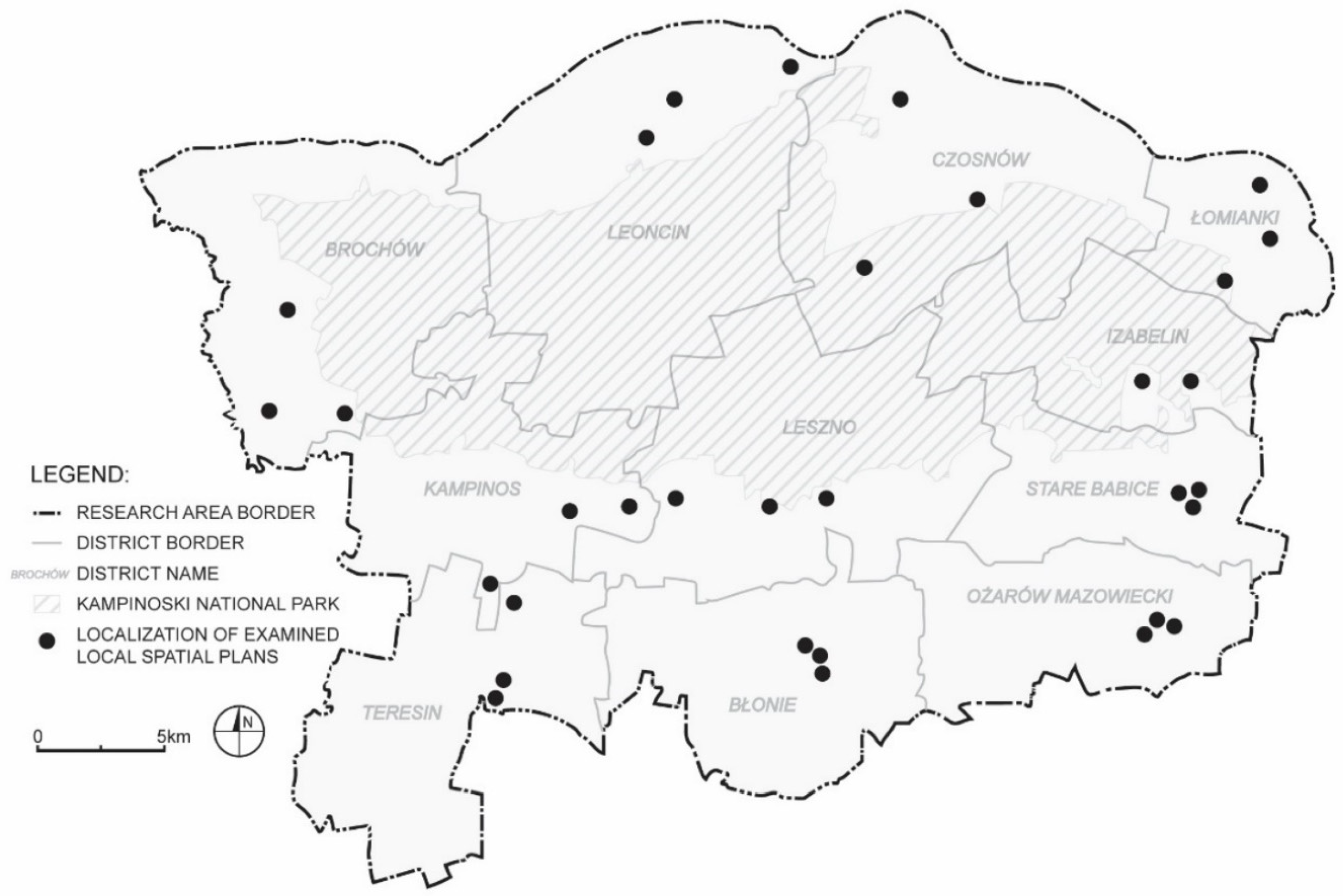
It seems that proper regulation of water management rules in such a specific, demanding area would improve the current situation. For this area, and thus for Kampinos and its surroundings, a water and space management program was developed by the Marshal’s Office of the Mazowieckie Voiodeship in 2016, although it has not yet been implemented. This program is to be concentrated on new investments in hydrological equipment. Spatial planning issues are neglected although many problem areas are noted here (Figure 4). That is why we decided to research the situation with planning documents within the entire problem area covered by this program, concerning 11 communes belonging to three poviats. The authors investigated the provisions of local documents regarding spatial planning and the occurrence of water problems. The choice of plans was made according to the methodology described in the previous section, and the distribution of the assessed plans on the map of the study area is presented in Figure 5.

2.3. Description of Reference Plans, to Establish a List of Provisions of Regulatory Plans

The authors examined two reference plans from other territories with many detailed water management arrangements. They concern larger and more complex settlement centers than those in the studied area. However, we were guided by the fact that the reference plans cover areas with many complex water management problems and that these were studies of high quality.

2.3.1. Ørestad, Copenhagen

The first one concerns The Neighborhood at Bella Center II, located in Ørestad in the district Amager Vest, Copenhagen—Local plan No. 571 and supplement to the city plan No. 21, adopted by the Citizens’ Representation on 17 January 2019 and announced on 7 February 2019 [65].
In the first part, the plan includes general statements in the field of local rainwater management and cloudburst protection, relating to higher-level documents. Here, consistency with the other planning and legislation is confirmed. For example, coherence with: (1) the City of Copenhagen’s Wastewater Plan 2008 with a supplement, (2) the Local Rainwater Diversion, LAR with a handbook that generally describes a number of methods and solutions, (3) the Cloudburst Plan adopted by the City of Copenhagen in 2012, and (4) the City of Copenhagen’s Water Supply Plan. The most important statements contained in this section either repeat these documents or justify the content of the detailed provisions of the plan. It follows from these General Guidelines that rainwater must, as far as possible, be handled locally. It can be collected, recycled, delayed, evaporated, infiltrated and/or discharged into the water area. If building materials are used that can release pollutants into the rainwater, cleaning measures must be established before the water can be infiltrated or discharged to a water area. Rainwater can be used for irrigation, fountains, laundry, car washing or toilet flushing etc. Rainwater for toilet flushing and laundry cannot be allowed in day care institutions, schools, nursing homes and other institutions for particularly sensitive groups. There are also general arrangements for protection against floods and torrential rains, indicating that the local plan area must be secured against flooding as a result of cloudbursts when designing buildings and terrain in such a way that the water is handled on the surface and flows away from buildings.
Detailed arrangements are made in the main part of the plan, written in the form of a legal act. The following are those relating to the management of rainwater and are included in § 10: “Rainwater”:
(1)
Rainwater on terrain
(a)
Rainwater from non-congested areas must be led to the surrounding canals and ditches.
(b)
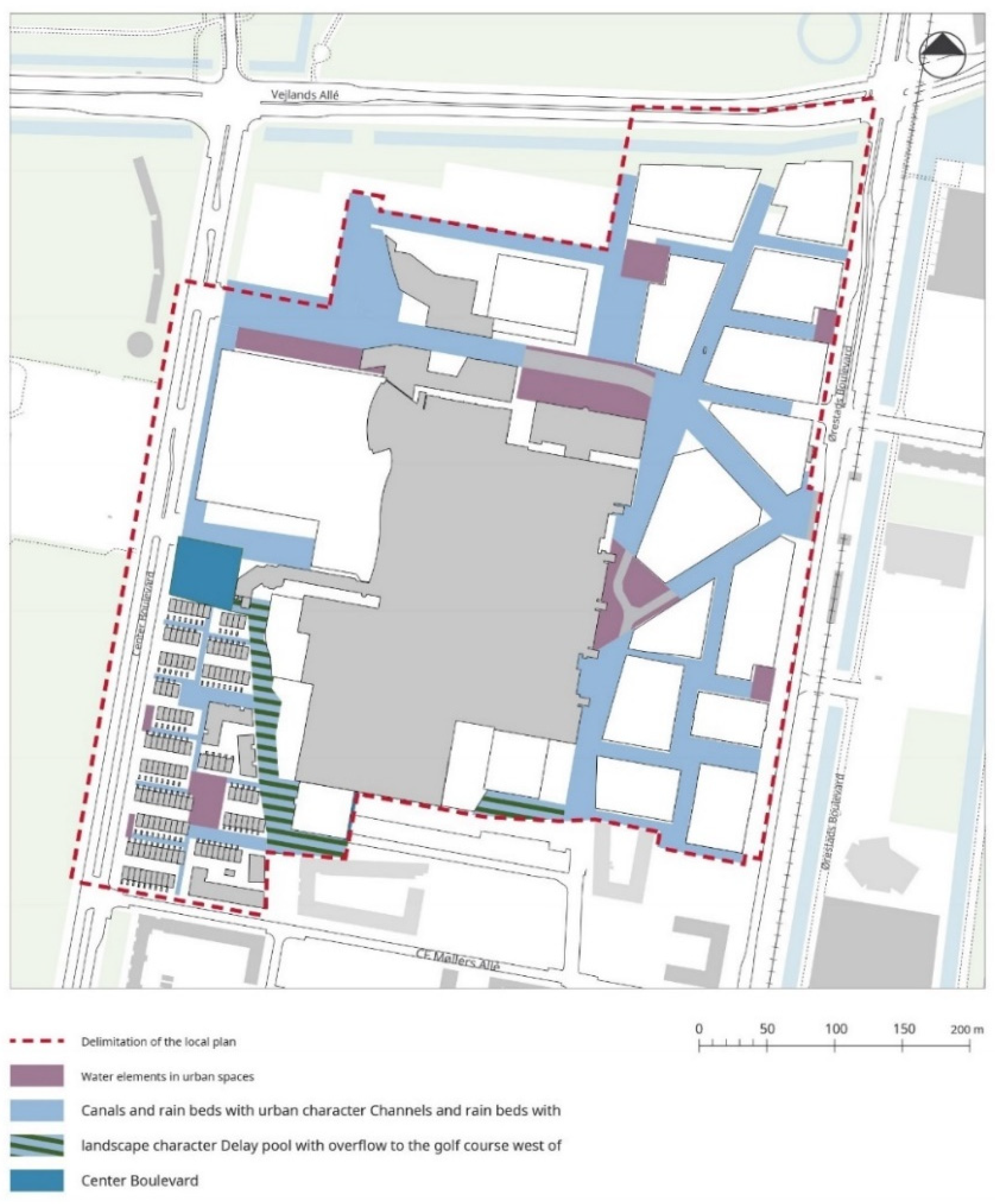
Within the area, unpolluted water shall be led in canals and rain beds and basins integrated in the area’s roads, streets and squares as shown in drawing No. 8.
(c)
Stowage basins may be designed in a double function, so that during dry periods they serve another practical or recreational purpose.
(d)
Rain beds must be designed as beds with plants, reeds, grasses and possibly trees that can be submerged during humid periods
(e)
Design of rain beds, canals, water elements, stowage basins and water technical systems must take into account hydraulic/technical conditions.
(2)
Cloudburst protection
The area must be secured against cloudburst by diverting surface water directly to Kalvebod Fælled via the golf course west of the area or via the surrounding canals, so that below a 100-year cloudburst maximum, there is 10 cm of water on the terrain.
It should be noted that the above findings relate to the planning drawing, which is an integral part of this plan. All the most important designed areas and water devices are clearly marked on it (Figure 6).
Additionally, in the plan arrangements, detailed guidelines were introduced regarding the foundation of buildings in a way that would protect them against storm surge. The local plan area must be secured against flooding as a result of cloudbursts when designing buildings and terrain in such a way that the water is handled on the surface and flows away from buildings. Therefore, provisions for this have been incorporated in the local plan. It is incorporated in the local plan that there must be a terrain elevation for buildings of at least 2.63 m where possible. The buildings and the usual building equipment, which are central to all operation of the building, should also be secured against a storm surge of 2.63 m. Construction can be secured against storm surges, if possible, without this appearing to be a barrier.

2.3.2. Czerniaków South, Warsaw

The second reference plan was developed for South Czerniaków, in the Mokotów district, Warsaw. The plan was adopted by the Warsaw City Council in 2019—resolution No. XV/349/2019 of 4 July 2019 and published in the voivodeship official journal, 2019, No. 9006 [66].
The plan contains general arrangements for the entire study area, relating to the problem of water management. The most important provisions regarding water management and protection are contained in §13 and §28. The most important findings are set out below.
§ 13. With regard to the protection of surface and ground waters, it is established:
(1)
prohibition of making permanent unfavorable changes in water conditions, in particular drainage and other works resulting in a permanent lowering of the groundwater level or limiting the supply of aquifers, water courses and water reservoirs, if they serve purposes other than nature protection and rational water management;
(2)
an order to preserve and protect the existing water reservoirs and watercourses;
(3)
an order to take into account the need to periodically supply Czerniakowskie Lake with clean, retained waters in areas marked on the map;
(4)
an order to maintain an appropriate distance of new buildings from surface waters, expressed in the course of the building lines presented in the plan drawing;
(5)
prohibition of polluting surface waters by discharging untreated rainwater and snowmelt into these waters;
(6)
prohibition of using septic tanks and other solutions that may pollute groundwater;
§ 28. In terms of rainwater, it is established:
(1)
for the areas of existing buildings—permitting the discharge of rainwater in the current manner, through rainwater and combined sewage system;
(2)
for other areas—an order to manage rainwater in the place where it arises, and allowing its retention by:
(a)
tanks on building plots;
(b)
water reservoirs in areas marked on the map;
(c)
admission of water discharge to areas marked with the symbol IH/ZP, i.e., areas of hydrographic facilities and devices with park greenery,
(d)
an order to build a chain of infiltration basins and bioretention basins in all areas of IH/ZP and in the area of: A15.2. ZPW, before the implementation of new buildings on undeveloped areas; these reservoirs should be connected in a cascade so that any excess water flows by gravity from the basin to the lower basin and (after cleaning to the level required by separate regulations) to Czerniakowski Lake, whose sections are marked in the plan drawing;
(3)
the obligation to treat rainwater or snowmelt in tight, open or closed sewage systems from contaminated sealed surfaces in accordance with the requirements of separate provisions;
(4)
prohibition of shaping the plots’ surface in a way that may cause rainwater or snowmelt to run off them on the adjacent plots, subject to point 2 lit. c and d.
The drawing of the plan shows the course of a strictly defined sequence of infiltration and retention basins, as well as the approximate location and shape of the more important open reservoirs (Figure 7).
Additionally, the plan includes arrangements for protection against flooding. The most important of the entries on this topic is quoted below: “The entire district covered by the plan is located in areas exposed to the risk of flooding and inundation, i.e., in areas exposed to flooding in the event of destruction of or damage to a flood embankment, as well as in the area of the Vistula valley, where a periodic rise in the groundwater level may occur during high water levels of the river. The plan states that this circumstance should be considered when designing construction facilities and land development. For example, the following arrangements have been made: (1) all investments should be designed and implemented with the use of precautionary measures against rising groundwater levels; (2) it is allowed to build garages on the above-ground stories of residential and service buildings”.

2.3.3. Synthesis of the Most Important Planning Regulations in the Field of IWMR in the Examined Reference Plans—Checklist Construction and Evaluation Rules

In the two local spatial plans examined, there were many different regulations concerning integrated water management through proper investment and land development. Some of them are more detailed, others are less detailed, and some are specific to the plan development area. However, we undertook to synthesize these provisions and select from them, those that can be considered universal and obligatory—as the minimum standards of requirements for local plans. The list of such orders and records is as follows:
  • Prescription to handle rainwater locally.
  • Indication that unpolluted water should be run in canals and rain channels, and in pools.
  • Arrangements for the rules of designing and development of the most important elements of green infra-structure, including reservoirs and waterways, bioretention and infiltration basins.
  • Indications on the location of the main rainwater receivers that can receive water during heavy rains.
  • Guidelines for the foundation of buildings in a manner that protects against high groundwater levels and against torrential rains
  • Prohibition of making permanent unfavorable changes in water conditions, resulting in a permanent lowering of the groundwater level or limiting the supply of aquifers, water courses and water reservoirs.
  • Prohibition of polluting surface waters by discharging untreated rainwater and snowmelt into these waters.
The set proposed in this way was used as a checklist to evaluate the provisions of the examined local plans.
We tested whether there were any arrangements in the text of the local plan, included on the checklist in points A to G, and whether they were complete or residual. Each requirement of the plan, that is, each of the checklist’s points was assessed as follows: no record = 0 points, partial, inconsistent record (the presence of limited, residual findings) = 1 point, complete and comprehensible record = 2 points.
In the overall assessment whole plans received a score consistent with the sum of the partial points obtained: Plans without any records were rated as poor, plans with a score of 1–4 points—on average, plans with a score of five or more—good.Finally, the results for individual planning records in all municipalities were compared, obtaining a general view of which of them were more or less used in the study area.
It should be noted that the reference plans contain strict arrangements for the intended use of the land for water devices, reservoirs, water courses, and for green infrastructure, which is shown on the maps (Figure 6 and Figure 7). In our study we also analyzed the graphic parts of local plans, checking whether they showed such findings related to the ground, and buffer zones near watercourses and reservoirs or areas excluded from development in particularly sensitive sites. The results of these analyzes were treated as an additional comment, not an element of the assessment, which was concentrated on the text parts of the plans.

3. Results

3.1. Analysis of the National and Regional Guidelines for Local Spatial Policy

Until the end of 2020 the highest in the hierarchy of state planning acts in Poland was the concept of spatial development of the country, which was defining the framework for shaping spatial policy. Currently, due to the initiated reforms of the planning system, there is no such document in Poland, therefore we have examined the national Concept of Spatial Development of the Country 2030, drawn up in 2011, adopted by the Council of Ministers [67]. It presents a vision of the increased resistance of the country’s spatial structure to natural and anthropogenic threats, including through balanced water management. In this vision, the model of socio-economic development is conducive to the restoration of traditional agricultural landscapes, the preservation of river valley ecosystems and the restoration of local watercourses, as well as using the buffer capacity of wetlands and polders in flood protection. The network of national natural connections must be the basis for the proper functioning of the economy, it should be taken into consideration when locating transportation and hydrotechnical infrastructure, and when planning the spatial development of cities and rural areas. Water resources should be rationally used for the needs of the national economy, with care for the quality of water ecosystems. The hydrotechnical development of rivers should be significantly limited, and their valleys shaped as much as possible so that they retain excess water, slow down its runoff and allow water to spill over. The implementation of the Water Framework Directive should allow for achieving the good condition of natural waters and good potential of artificial and heavily modified waters. The increase in natural retention should be supported by the restoration of rivers and small watercourses, restoration of natural floodplains during floods, increased forest cover, and agrotechnical changes in crops. Spatial policy is to aim at:
  • increasing the level of protection against extreme natural phenomena thanks to technical investments and non-technical activities,
  • integrating activities carried out in areas exposed to the risk of flooding,
  • integrating spatial planning carried out within the boundaries of administrative units with modern water management planning documents developed within the boundaries of hydrographic units and water regions,
  • increasing the buffer capacity of landscape structures,
  • increasing the ability to adapt space to the effects of climate change.
It was assumed that conducting a rational anti-flood policy and counteracting the effects of drought requires support in the regulatory and integrative functions of spatial planning. This will allow, apart from the location of infrastructure investments, the use of non-technical methods to slow down the outflow of flood and rainwater from the catchment area of overflowing rivers by using the buffer properties of some ecosystems and spatial structures. In areas at risk of flooding, torrential rains, and strong winds, building standards should be introduced to support resistance to natural hazards, including increasing the use of rainwater in urbanized areas and reducing its runoff to the sewage system. Retention needs in river basin districts and methods of action to obtain a retention rate of 12–15% of the average annual runoff from Poland (7–9 billion m3) should be specified to consistently introduce them into spatial development plans. The work will consider the retention potential of natural structures and microretention by the facilities as well as previously defined standards for providing water for food production in agriculture and agri-food processing. In agglomeration areas, the obligation to retain rainwater will be introduced in order to reduce floods in dense development areas, to use the obtained resource to maintain the green infrastructure of urbanized areas and, as the value of water collected for the living needs of the population increases, for other applications [67].
This ambitious concept was implemented in the voivodeship plan, although not all of its elements were directly translated to this level. The lower level of spatial development plans, i.e., general and local plans, should be basically consistent with the plans of the voivodeships, so the authors analyzed their regulations. The research area concerns the “Spatial Development Plan for the Mazowieckie Voivodeship”, approved by Resolution No. 22/18 of the Mazovian Voivodeship Parliament of December 19, 2018 [68].
In terms of water infrastructure and wastewater treatment, the plan takes into account public purpose investments of supra-local importance aimed at construction of rainwater drainage and treatment systems from urbanized areas, main transportation routes, and industrial areas. As regards water protection in the Mazowieckie Voivodeship, the plan defines the following measures, organized as follows
(1)
natural elements protection:
  • protection of natural elements (including oxbow lakes, peat bogs, swamps, ponds, seasonal pools) and restoration of anthropogenically transformed areas (in particular river valleys);
  • protection of the main groundwater reservoirs and protection zones of water intakes (surface and groundwater);
  • protection of spring areas;
  • striving to ensure comprehensive protection of river catchment areas;
  • development of riverbanks, mainly the Vistula, in accordance with the requirements of the protection of natural, landscape and cultural heritage values.
(2)
activities to protect against natural hazards:
  • increasing the flood safety of intensively developed areas and structuress that may pose a threat to the environment, public utility structures and valuable cultural heritage, etc.;
  • taking into account flood hazard maps, flood risk maps, flood risk management plans and the Plan for counteracting the effects of drought in the Central Vistula water region;
  • counteracting the effects of floods and droughts, including in cooperation with neighbouring voivodeships;
  • implementation of investments in the field of flood—protection provided for in the Water Management Plan for the Vistula river basin;
  • ensuring a high level of technical and organizational security in the field of random events and crisis situations related to the main rivers of the region, including with the Vistula River;
(3)
increasing the voivodeship’s water retention:
  • construction of small water reservoirs, damming up water in streams and lakes, reconstruction of ditches and canals, retention of rainwater and proper shaping of the structure of agricultural and forest areas and the creation of plant protection zones in municipal planning documents;
  • maintaining and increasing the existing retention capacity of the catchment area by, among others, reducing the runoff of rainwater and snowmelt from the catchment area, increasing various forms of water retention;
  • limiting development in areas of particular flood risk;
  • renaturalization of anthropogenically changed sections of rivers and floodplains;
  • increasing the use of rainwater and meltwater.
Such a plan could contain more detailed guidelines for water retention, drainage and storage systems, show more important receivers, or areas that should remain infiltration-active in their entirety, without buildings. It does not contain any guidelines regarding protection against heavy rain, it does not indicate a general approach to the principles of building foundations, and it does not mandate integrated works for water and space management. Therefore, it is considered that this plan should be assessed as medium, and at least not of the highest quality.
Environmental protection programs and development strategies are also prepared at a slightly lower level of planning than the provincial level, i.e., the level of poviats, but they do not translate into the planning system. The most important thing is that the guidelines of the voivodeship plan should be reflected in the general plans of communes, as they are the direct guidelines for local spatial development plans. They have been thoroughly tested.

3.2. Characteristics of the Local Policies of Communes, Expressed in Local General Plans (Local Comprehensive Plans)

The analysis concerned the current general plans in 11 communes, which covers the entire area of research. Individual general plans were made in different techniques and to a different extent (they were adopted over a decade). The analysis showed that in some communes, issues related to water management were completely omitted in the text part, in others issues related to the current state were not addressed.
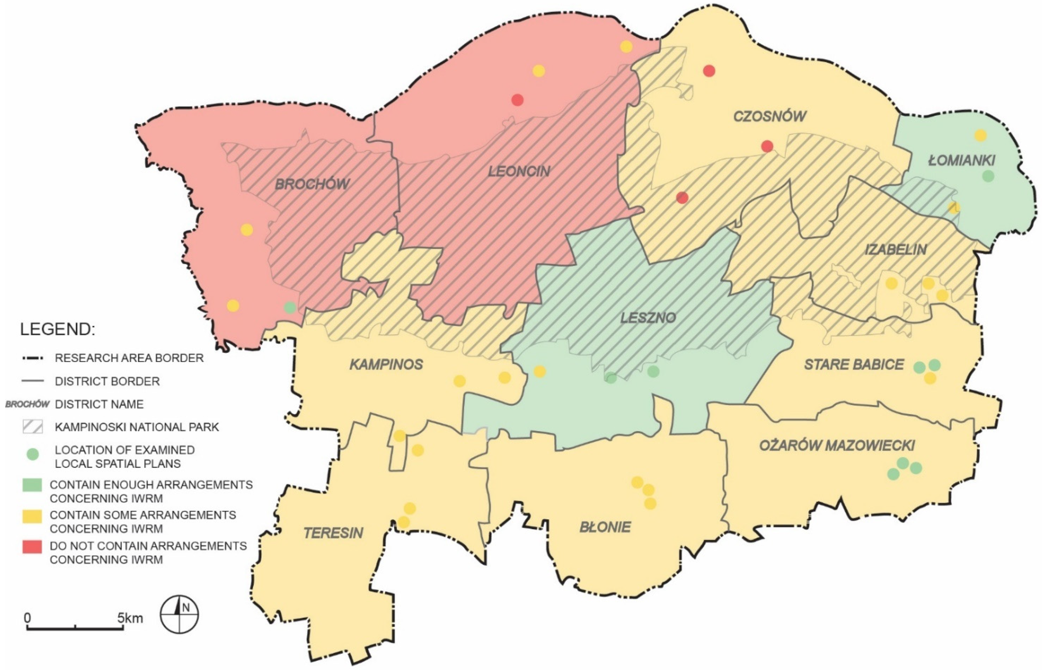
In the general plans for two municipalities: Leoncin and Brochów, no provisions concerning water management were made at all. The principles of integrated management of rainwater in the communes of Leszno and Łomianki were described most fully, so they were rated very highly. For example, the city of Łomianki introduced clear and fairly precise provisions regarding protection against floods, including by indicating areas excluded from development and with limited development possibilities in the Łomiankowska Valley, as well as text entries. It was established that it is necessary to stop the increase in flood risk, reduce the existing flood risk, and improve the flood risk management system, including through: (1) development of a catalog of structures, the location of which should be prohibited due to possible (in the event of a flood) negative effects on the environment, (2) development of technical conditions under which structures can be located in areas at risk as a result of failure of embankments, (3) development of recommendations for existing facilities in the scope of possible methods of protection against losses due to the failure of embankments. The Leszno commune clearly specifies that up to 30% of rainwater on a property should be retained.
The municipalities of Ożarów Mazowiecki, Izabelin, Czosnów and Stare Babice also introduced provisions concerning the rules of rainwater drainage, although these are very general, and sometimes inconsistent. The Teresin commune emphasized only the construction of a retention reservoir. The municipalities of Kampinos and Błonie dealt with the issue of rainwater management in a perfunctory manner. Relevant provisions were introduced by the commune of Izabelin. Therefore, the general plans of these communes were assessed as insufficiently taking into account the problems of water management.
As a result, the distinguished three groups of general plans are as follows: 1. not considering the subject of water: Leoncin, Brochów, 2. taking into account the subject matter but insufficiently: Ożarów Mazowiecki, Izabelin, Czosnów, Stare Babice, Teresin, Kampinos Błonie, and 3. properly taking into account the subject of water: Łomianki, Leszno.
The study showed that the issues of integrated water management are not sufficiently taken into account when shaping the functional and spatial structure, as evidenced by the analyzed drawings of general plans. And this applies to all surveyed communes. The areas designated for development exceed the needs resulting from all demographic forecasts, but also the possibilities of communes to fully equip the areas with social, technical and transport infrastructure, including infrastructure for the management of rainwater. The following data was obtained from the estimated analyses: (1) area of the areas indicated in general plans for residential buildings—279 km2; (2) absorptive capacity of areas intended for housing development—837,420 people; (3) current number of inhabitants—132,000 people.
In the areas subject to the greatest urbanization pressure, i.e., the ones closest to Warsaw and the most attractive in terms of nature, the areas to be built-up, indicated by municipalities, almost completely fill all the spaces between the areas strictly protected by separate regulations in the field of nature protection. Bands of areas excluded from development are not introduced between them, including between the existing villages and separate settlement units. These could structure the development, as well as constitute infiltration-active spaces, enabling retention, or a place for the location of water management devices. The areas designated for development reach the borders of forests, watercourses, and often ditches, canals and rivers are not shown in general plans drawings at all.

3.3. Assessment of the Chosen Local Spatial Plans

The analysis of the local spatial development plans was carried out on the basis of a checklist, previously described. Detailed data are available in the Supplementary Material.
The analysis showed that the regulations of the examined local development plans in the field of the rainwater management are negligible. The maximum score for one type of textual regulation (from A to G) for all 33 analyzed plans in total could amount to 2 × 33 = 66 points. The best was the answer to the answer A, scoring 33 points. This most common provision was one regarding the prohibition of water pollutionout of 33 plans examined, as many as 20 have arrangements in this regard. However, it must be added that the Water Law which is in force in Poland also has such a requirement [69]. Therefore, such arrangements in the local plans in this regard are generally not needed. Some local spatial plans contain prohibitions on the permanent change of water relations (13 out of 33 examined), although this provision is also identical to the national regulations. As for the essential requirements for rainwater management, they are either ambiguous or very general. Three quarters of the local plans have the requirement of local management of rainwater. More precisely, however, these plans usually contain a provision stating that rainwater should be drained directly into the ground, onto the plots of land. Only 8 plans provide a bit more detailed regulations on this. No solutions are proposed for larger building complexes, nor even suggestions as to the method of water retention. As many as 19 plans indicate the need to build canals, ditches, or rainwater drainage systems, but only 7 contain slightly more detailed guidelines in this regard, and only two plans include guidelines for the location of rainwater discharge in the event of heavy rains. Several plans indicate open water areas in the drawing attachments, but these are existing rivers, ponds or canals and ditches of former agricultural drainage. In the text of the plans, the issue of water management is not related to the existence of these watercourses and reservoirs, i.e., the drawings do not indicate on the ground any new connections through greenery, alleys, networks or canals of built-up areas with these existing water areas.
No analyzed plan supports comprehensive rainwater management, nor contains any creative planning solutions for organizing water collection, limiting the effects of flooding and inundation, supplying Kampinos Forest, or creating reservoirs for irrigation of other areas where water is predominantly lacking. The critical situation of this area has its justification, which is the lack of local spatial policy in the field of water management and instruments to solve local problems directly on the ground.
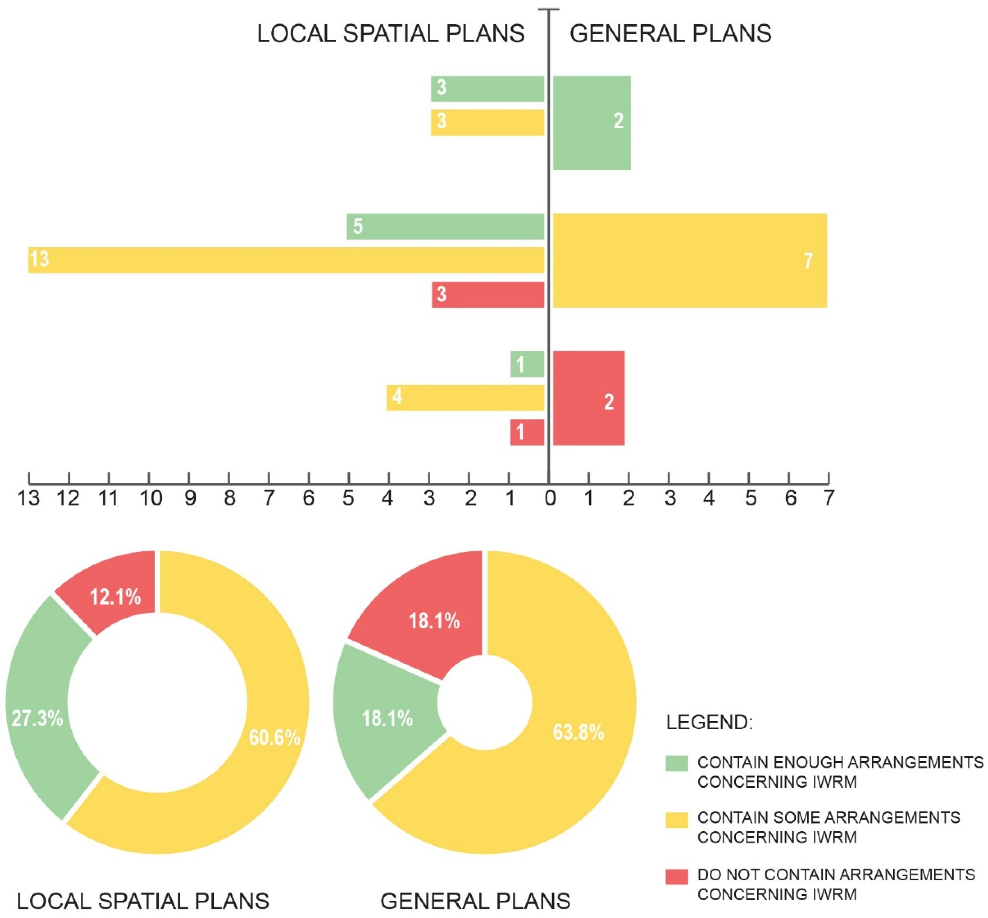
None of the plans scored similar to the reference plans, although individual plans received maximum scores for some components (Figure 8). None of the examined plans had provisions for the category E: “Guidelines for the foundation of buildings in a manner that protects against high groundwater levels and against torrential rains”. For this reason, the assessment in this category did not affect the overall result of the comparisons. However, apart from the communes of Ożarów, Błonie, Teresin and Leszno, the above-mentioned regulation should be obligatory due to the high level of groundwater and the observed flooding.
In general, the issue of water management is almost completely ignored in this sensitive territory. Local plans prepared in a manner corresponding to the reference plans obtained a maximum of 8 points in this assessment. Meanwhile, 4 plans scored zero points, most of the plans (almost 20) received a score of 1 to 3 points, while only five of 5 or 6 points. The timing of the preparation and adoption of the plans did not affect the scope of the arrangements. It may be assumed that the adoption of the Water Law in Poland [70], which brought Polish regulations into compliance with the EU Water Framework Directive, did not have a significant impact on the compactness of the local plans. In addition, the increasing extreme flood phenomena and the growing social awareness of the effects of climate change have not contributed to the improvement of local legal acts in the field of water management. And so, in the Czosnów commune, the plans obtained 0 points, regardless of whether they were adopted in 2003, 2008 or 2012. In several municipalities, such as Ożarów Mazowiecki, Stare Babice and Łomianki, these older plans had even better stormwater management arrangements than the newer ones. The quality of the plan was not influenced by its location in a given poviat, although communes differ from each other. The commune of Ożarów Mazowiecki definitely stands out, with a total of 22 points for three plans (7.33 points/plan). This can be explained by the fact that this commune has the most intensive development planned, which required more detailed arrangements. Despite this exception, the conclusion can be drawn that the poor quality of general plans translates in part to the quality of local plans (Figure 9).
Criteria developed during research can also be guidelines for the preparation of local spatial development plans and may be used in other areas and planning acts.

3.4. The Scope of Implementation of Development Policies for the Studied Area with the Use of Planning Instruments

After the assessment of planning documents, the objectives set at the national level were compared with the Voivodeship Spatial Development Plan, with the spatial policy at the municipal level and with planning tools such as local development plans (Table 1).
This comparison showed, that despite the very well-articulated national policy in the field of integrated water management, all lower-order documents incorrectly translate it into local plans and actions in the field. This, in turn, results in the lack of proper tools for implementing this policy. The study for the voivodeship already contains fewer guidelines and political indications than the national plan, although the opposite should be the case, as it is prepared for a much smaller area of land. The general plans of communes prepared on the basis of this voivodeship plan are of different quality. Two general plans are superior to the provincial plan in quality, two are completely unacceptable and the rest are in line with the provincial level.
The relationships between a good general plan and good regulations of local plans are noticeable, however, the same is true of poorly executed general plans—they translate into poor local plans (Figure 10). There is an exceptional situation in one of the communes, where, despite the average quality of the general plan, local plans are good (on the scale studied). However, they all lack a lot in terms of the quality of reference plans. In general, it can be assessed that with such a low quality of planning studies, the implementation of national and EU policy in a specific, sensitive and demanding area, such as the one studied, is completely ineffective.

4. Discussion

In the current Polish system of spatial planning, water management issues should be included in the planning studies prepared at all levels of public administration—from the National Spatial Development Concept to local spatial plans. In practice, this system is not always effective, as shown by the analysis of planning and strategic studies, and above all, by the poor translation of national and regional strategies and plans into the regulations of the general plans and local spatial plans. Thus, theoretically, in Poland there is a hierarchical spatial planning system, the efficiency of which is low, as confirmed by the research carried out.
It is not certain also whether the conducted research proved the ignorance of local governments and planners, or rather the weakness of the Polish planning system in general, which was noticed, among others by Śleszyński [21], Woźniak [22] and Zybała [23]. Certainly, however, the lack of “good” local spatial development plans and their integration with the entire planning system has a negative impact on many urban subsystems, and water management is one of the more important of these. The research has shown that one of the reasons for the critical hydrological situation in the examined part of the Warsaw agglomeration may be the lack of appropriate spatial development plans. If we extrapolate these results to the features of Polish spatial development plans, which seems justified given the scale of the research carried out, this evaluation also revealed the weakness of Polish spatial development plans in this matter. Therefore, research to improve them is justified.
In our research we deliberately analyzed local plans in a particularly sensitive and complex area of supra-local importance. We felt that an area with so many social, environmental and economic problems and facing various extreme water phenomena should have carefully designed and effective local plans. Although we assessed selected 33 plans in a detailed and systematic way, we got acquainted with almost all local plans for the area available on the Internet. None of them looked more detailed or precise than the ones examined. All this led us to the conclusion that the problem of water is not taken seriously by planners and local governments who commission them to carry out local plans.
As part of the discussion, one should also mention an important thread, which was only outlined in the article, but not deepened, due to the adopted scope of research. One of the most important tasks of local planning is the proper shaping of the functional and spatial urban structure. In accordance with good planning practices and the aspirations to shape compact cities [71,72,73], the aim should be to form dense building complexes and concentrate them on areas equipped with social and technical infrastructure or with real opportunities for such facilities. Open areas including undeveloped areas, should separate individual building clusters from each other, creating a clear structure of the area and allowing for the shaping of ecological sequences, ventilation strips, and areas supplying the natural system. Few of the analyzed plans meet this criterion. Spatial development projects are characterized by little creativity, no planned greenery routes, new waterways or reservoirs. The issues of rainwater management are usually treated quite casually and selectively.
Of course, one should take into account the fact that the planning situation in individual communes is very diverse. The areas are covered with local plans concerning areas from several to one hundred percent of the entire area. The level of detail of the plans varies. Some of them were prepared on the basis of the Act of 7 July 1994, on spatial development [74], which did not define the obligatory scope of arrangements, others on the basis of the Act of 27 March 2003, on spatial planning and development [75]. This may, however, lead to the conclusion that all previously adopted local plans should be updated, taking into account, inter alia, IWRM. But if the issue of sustainable water management is to be taken seriously in local planning, it is essential to rely on accurate data during planning work. This should apply to various environmental, spatial and social conditions and forecasts, including quantitative and spatial data such as population density, water consumption, potential of water receivers, expected number of inhabitants and users, rainfall amount, etc. In Poland, water management has always been mainly conducted to make the most profit for investors. The issues of broadly understood water management meet with only superficial interest in the society and the media. After joining the European Union in 2004, Poland was obliged to implement the Water Framework Directive; however, in principle, it was not until 2001 that the amended Water Law was passed [70], which now, after changes in 2017, includes new definitions, new organizational structures as well as the idea of the active public participation and transparency of all of the procedures [76]. However, this does not mean that it is already implemented in all fields. Taking care of “spatial quality”, concern for the environment, or even the future consequences of climate change are still perceived as a luxury that Poles cannot afford at present [77]. The contribution of public authorities to new joint investments is negligible and the organizational mess in matters related to water management is enormous. This is combined with the weakness of the planning system, the lack of development plans for some parts of the country, and the low quality of those that are adopted. Such a policy is far from being an integrated approach to planning urban transformation based on the assessment of ecosystem services which is currently proposed [78]. Therefore, the results of the research carried out should be one of the key elements in improving the current situation in local planning.
Writing good rules into local development plans has a double value. On the one hand—they must define the principles of construction, foundation of buildings, organization of drainage and irrigation, protection against floods and flooding, location of investments, shaping the green and blue infrastructure, etc. If they do not contain such provisions, it means that they permit everything available under national regulations. And those in terms of water management are not particularly strict and detailed. So, the lack of these provisions makes it impossible to implement the assumed water policies. Another aspect should not be forgotten—the informative role of local plans, the possibility of influencing the awareness and approach of investors and residents to the problems of integrated water management.
The checklist proposed by us can be used not only in the assessment of local plans, but as a tool helping to formulate the texts of the plans that will serve the purpose of sustainable water management. A modification of the proposed checklist may be considered according to the nature of the area covered by the plan. Perhaps we have unnecessarily introduced category E as the required regulatory scope for all plans, while in some areas where there are no problems with flooding and high groundwater levels or the need for deep foundation, this provision does not need to be introduced. Probably the adoption of reference plans prepared for quite intensively developed areas or for cities should result in applying it to plans for areas with similar characteristics. There may be concerns as to whether the selected reference plans for large cities are appropriate, given that the studied area has a different functional and spatial structure. On the other hand, it is difficult to find areas developed similarly to Polish suburbs, dominated by individually implemented, extensive housing development on large areas of land [64,79,80]. Therefore, the authors decided that it would simply be based on the best examples of plans for urbanized areas, although the search for an appropriate reference plan for dispersed suburbia could be the next stage of the research. It can be explained that the authors did not make the wrong assumption, because four additionally tested high-quality local spatial plans, both for Warsaw and for suburban areas, received a high rating. Therefore, this could mean that it is possible to apply the proposed plan’s provisions in almost every area.
This was confirmed by carrying out a test evaluation of the texts of 10 selected plans from several European countries [including the reference plans of Ørestad (Copenhagen) Orestadt and Czerniaków South (Warsaw), which received the highest scores: 14 and 12 points] (Table 2). The implication of the results would require separate analyzes, but a general view of the scores obtained gives a picture of different approaches to shaping local development plans and allows to evaluate them.

5. Conclusions

The results of the study showed that for an extremely fragile and difficult terrain struggling with water management, local spatial plans have been adopted that completely or largely ignore this problem. Thus, the possibility of influencing land use and water management through planning documents is not used at the area of the researched case study. We have drawn attention to the fact that this is worrying and that it can be changed by updating existing local plans and taking into account our guidelines when drawing up new ones.
We also showed the best practices in the field of formulating the texts of local plans, and synthetically analyzing them, we presented the most important scope of legal arrangements regarding the IWRM. This can be used both for evaluation and for the preparation of local spatial plans in other regions of Poland and Europe in terms of their suitability for supporting water management. Thus, the presented research results can be both implemented in planning practice and scientifically developed further.
While the transition towards resilience is welcome due to climate change, implementing these strategies faces many difficulties across Europe [81]. As an integrated approach to water resource management, as set out in Agenda 21, is expected to be a key and continuously improved component of emerging green economy strategies in the context of sustainable development as well as a key element in building climate resilience. In response to Agenda 21′s call for institutional, legal, and financial mechanisms, over 80% of countries have introduced changes to their water resource management rules. Still, progress with actual infrastructure development and real changes on the ground are at an advanced or fully implemented level in a low proportion of areas [12,82]. Methods to help respond to this challenge should be developed and refined. We hope that our research can help in this.

Supplementary Materials

The following supporting information can be downloaded at: https://www.mdpi.com/article/10.3390/su14105766/s1. Table S1: Checklist for assessment of plans.

Author Contributions

K.S. writing—original draft; K.S. conceptualization; K.S. methodology; K.S. investigation; K.S. funding acquisition; M.K. software; M.K. figures; K.S. and M.K. resources. All authors have read and agreed to the published version of the manuscript.

Funding

This research was funded by Warsaw University of Technology, Faculty of Architecture, grant number 504/04187/1010/44.000000.

Institutional Review Board Statement

Not applicable.

Informed Consent Statement

Not applicable.

Data Availability Statement

Not applicable.

Conflicts of Interest

The Authors declares no conflict of interest. The funder had no role in the design of the study; in the collection, analyses, or interpretation of data; in the writing of the manuscript, or in the decision to publish the results.

References

  1. Downing, T.E.; Butterfield, R.E.; Edmonds, B.; Knox, J.W.; Moss, S.; Piper, B.S.; Weatherhead, E.K.; CCDeW Project Team. Climate Change and the Demand for Water; Research Report; Stockholm Environment Institute, Oxford Office: Oxford, UK, 2003. [Google Scholar]
  2. Arnell, N.W. Climate change and global water resources: SRES emissions and socio-economic scenarios. Glob. Environ. Chang. 2004, 14, 31–52. [Google Scholar] [CrossRef]
  3. Richardson, D. Flood risk: The impact of climate change. Proc. Inst. Civ. Eng.-Civ. Eng. 2002, 150, 12765. [Google Scholar] [CrossRef]
  4. Vörösmarty, C.J.; Green, P.J.; Salisbury, J.; Lammers, R.B. Global water resources: Vulnerability from climate change and population growth. Science 2000, 289, 284–288. [Google Scholar] [CrossRef] [PubMed] [Green Version]
  5. Schreider, S.Y.; Smith, D.I.; Jakeman, A.J. Climate change impacts on urban flooding. Clim. Chang. 2000, 47, 91–115. [Google Scholar] [CrossRef]
  6. Bates, B.C.; Kundzewicz, Z.W.; Wu, S.; Palutikof, J.P. (Eds.) Climate Change and Water; Technical Paper; IPCC Secretariat: Geneva, Switzerland, 2008. [Google Scholar]
  7. Döll, P. Impact of climate change and variability on irrigation requirements: A global perspective. Clim. Chang. 2002, 54, 269–293. [Google Scholar] [CrossRef]
  8. Alcamo, J.; Flörke, M.; Marker, M. Future long-term changes in global water resources driven by socio-economic and climatic change. Hydrol. Sci. J. 2007, 52, 247–275. [Google Scholar] [CrossRef]
  9. Rogers, P.; Hall, A.W. Effective Water Governance; Tech Background Papers, 7; Global Water Partnership Technical Committee: Stockholm, Sweden, 2003. [Google Scholar]
  10. UNESCO; UN-Water. United Nations World Water Development Report 2020—Water and Climate Change; UNESCO: Paris, France, 2020. [Google Scholar]
  11. Serra-Llobet, A.; Conrad, E.; Schaefer, K. Integrated water resource and flood risk management: Comparing the US and the EU. In Proceedings of the 3rd European Conference on Flood Risk Management (FLOODrisk 2016), Lyon, France, 17–21 October 2016; Lang, M., Klijn, F., Samuels, P., Eds.; E3S Web Conference: Les Ulis, France, 2016; Volume 7. [Google Scholar] [CrossRef] [Green Version]
  12. UNEP. The UN-Water Status Report on the Application of Integrated Approaches to Water Resources Management; United Nations Environment Program (UNEP): Nairobi, Kenya, 2012. [Google Scholar]
  13. Reberski, J.L.; Köck, R.; Siegel, H.; Kuschnig, G.; Reszler, C.; Gerhardt, E.; Terzić, J.; Boljat, I.; Čupić, D.; Patekar, M.; et al. Strategy for the Improvement of Policy Guidelines. Capitalization: Capacity Building and Stakeholder Engagement; Technical Report; Interreg Central Europe, Proline-CE: Vienna, Austria, 2018. [Google Scholar]
  14. Larsson, G. Spatial Planning Systems in Western Europe: An Overview; IOS Press: Amsterdam, The Netherlands, 2006. [Google Scholar]
  15. Drzazga, D.; Markowski, T. Koncepcja systemu zintegrowanego planowania rozwoju w Polsce (założenia i zasady kierunkowe budowania systemu) [The concept of integrated development planning system in Poland (assumptions and directional principles of building the system)]. In Rozwój Obszarów Miejskich w Polityce Regionów [Urban Development in Regional Policy]; Klasik, A., Kuźnik, F., Eds.; KPZK PAN Studies: Warsaw, Poland, 2015; pp. 10–42. [Google Scholar]
  16. Nowak, M. The Role and Effects of Case—Low in Spatial Competition. An analysis of selected cases. Biul. Kom. Przestrz. Zagospod. Kraj. PAN 2017, 265, 172–180. [Google Scholar]
  17. Alexander, E.R. Introduction: Does planning theory affect practice? And, if so, how? Plan. Theory 2010, 9, 99–107. [Google Scholar] [CrossRef]
  18. Harrison, P. Making Planning Theory Real. Plan. Theory 2014, 13, 65–81. [Google Scholar] [CrossRef]
  19. Spaliviero, M.; Boerboom, L.; Gibert, M.; Spaliviero, G.; Bajaj, M. The Spatial Development Framework to facilitate urban management in countries with weak planning systems. Int. Plan. Stud. 2019, 24, 235–254. [Google Scholar] [CrossRef] [Green Version]
  20. Solarek, K. Struktura Przestrzenna Strefy Podmiejskiej Warszawy. Determinanty Współczesnych Przekształceń [The Spatial Structure of the Warsaw Suburban Area. Determinants of Contemporary Transformations]; OWPW: Warsaw, Poland, 2013. [Google Scholar]
  21. Śleszyński, P. Społeczno-ekonomiczne skutki chaosu przestrzennego dla osadnictwa i struktury funkcjonalnej terenów [Socio-economic Effects of Spatial Chaos for Settlement and Functional Structure of Areas]. In Studia Nad Chaosem Przestrzennym [Studies on Spatial Chaos]; Kowalewski, A., Markowski, T., Śleszyński, P., Eds.; Studia Komitetu Przestrzennego Zagospodarowania Kraju; PAN: Warsaw, Poland, 2018; pp. 29–32. [Google Scholar]
  22. Woźniak, M. Interes Publiczny i Interes Indywidualny w Planowaniu i Zagospodarowaniu Przestrzennym [Public and Individual Interest in Spatial Planning and Development]; Opole University Press: Opole, Poland, 2018. [Google Scholar]
  23. Zybała, A. Polityka Przestrzenna i Jej Rezultaty w Warunkach Rosnącej Złożoności Jej Problemów [Spatial Policy and Its Results in the Conditions of Increasing Complexity of Its Problems]. Studia Z Polityki Publicznej 2019, 2, 103–109. [Google Scholar] [CrossRef] [Green Version]
  24. Komornicki, T.; Szejgiec-Kolenda, B.; Degórska, B.; Goch, K.; Śleszyński, P.; Bednarek-Szczepańska, M.; Siłka, P. Spatial planning determinants of cohesion policy implementation in Polish regions. Europa 2018, 21, 69–87. [Google Scholar] [CrossRef]
  25. Nadin, V.; Fernández Maldonado, A.; Zonneveld, W.; Stead, D.; Dąbrowski, M.; Piskorek, K.; Sarkar, A.; Schmitt, P.; Smas, L.; Cotella, G.; et al. COMPASS—Comparative Analysis of Territorial Governance and Spatial Planning Systems in Europe Applied Research 2016–2018; Final Report; ESPON: Luxembourg, 2018. [Google Scholar]
  26. Lityński, P.; Hołuj, A. Urban Sprawl Risk Delimitation: The Concept for Spatial Planning Policy in Poland. Sustainability 2020, 12, 2637. [Google Scholar] [CrossRef] [Green Version]
  27. Ravetz, J. City-Region 2020: Integrated planning for a sustainable environment. Town Ctry. Plan. Assoc. Earthscan 2013, 1, 8–10. [Google Scholar] [CrossRef]
  28. Nowak, M.J. Integrated development planning and local spatial policy tools. J. Econ. Manag. 2020, 41, 69–86. [Google Scholar] [CrossRef]
  29. Yigitcanlar, T.; Teriman, S. Rethinking sustainable urban development: Towards an integrated planning and development process. Int. J. Environ. Sci. Technol. 2015, 12, 341–352. [Google Scholar] [CrossRef] [Green Version]
  30. Anderson, J.; Iyaduri, R. Integrated urban water planning: Big picture planning is good for the wallet and environment. Water Sci. Technol. 2003, 47, 19–23. [Google Scholar] [CrossRef]
  31. Dreiseitl, H.; Grau, D. (Eds.) New Waterscapes. Planning, Building and Designing with Water; Birkhäuser: Basel, Switzerland; Berlin, Germany; Boston, MA, USA, 2005. [Google Scholar]
  32. Ye, B.; Jiang, J.; Liu, J.; Zheng, Y.; Zhou, N. Research on quantitative assessment of climate change risk at an urban scale: Review of recent progress and outlook of future direction. Renew. Sustain. Energy Rev. 2021, 135, 110415. [Google Scholar] [CrossRef]
  33. UNEP United Nations Environment Program. Green Infrastructure Guide for Water Management. Ecosystem Based Management Approaches for Water-related Infrastructure Projects. 2014. Available online: https://portals.iucn.org/library/sites/library/files/documents/2014-026.pdf (accessed on 15 September 2014).
  34. Nauman, S.; Davis, M.; Kaphengst, T.; Pieterse, M.; Rayment, M. Design, Implementation and Cost Elements of Green Infrastructure Projects; European Commission: Brussels, Belgium, 2011. [Google Scholar]
  35. Jim, C.Y.; Lo, A.Y.; Byrne, J.A. Charting the green and climate-adaptive city. Landsc. Urban Plan. 2015, 138, 51–53. [Google Scholar] [CrossRef] [Green Version]
  36. Zardo, L.; Geneletti, D.; Pérez-Soba, M.; Van Eupen, M. Estimating the cooling capacity of green infrastructures to support urban planning. Ecosyst. Serv. 2017, 26, 225–235. [Google Scholar] [CrossRef]
  37. Wu, X.; Zhang, J.; Geng, X.; Wang, T.; Wang, K.; Liu, S. Increasing green infrastructure-based ecological resilience in urban systems: A perspective from locating ecological and disturbance sources in a resource-based city. Sustain. Cities Soc. 2020, 61, 102354. [Google Scholar] [CrossRef]
  38. Ran, J.; Nedovic-Budic, Z. Integrating spatial planning and flood risk management: A new conceptual framework for the spatially integrated policy infrastructure. Comput. Environ. Urban Syst. 2016, 57, 69–78. [Google Scholar] [CrossRef] [Green Version]
  39. Cilliers, D.P. Considering flood risk in spatial development planning: A land use conflict analysis approach. Jàmbá J. Disaster Risk Stud. 2019, 11, 537. [Google Scholar] [CrossRef] [Green Version]
  40. Al-Sabhan, W.; Mulligan, M.; Blackburn, G.A. A real-time hydrological model forflood prediction using GIS and the WWW. Comput. Environ. Urban Syst. 2003, 27, 9–32. [Google Scholar] [CrossRef] [Green Version]
  41. Smith, H.M.; Wall, G.; Blackstock, K.L. The role of map-based environmental information in supporting integration between river basin planning and spatial planning. Environ. Sci. Policy 2013, 30, 81–89. [Google Scholar] [CrossRef]
  42. Evers, M.; Krause, K.U. Integrative tools for land use and flood risk management. In Proceedings of the Real Corp 2007: 12th International Conference on Urban Planning and Spatial Development in the Information Society, Vienna, Austria, 20–23 May 2007; pp. 151–157. [Google Scholar]
  43. Porter, J.; Demeritt, D. Flood-risk management, mapping and planning: The institutional politics of decision support in England. Environ. Plan. A 2012, 44, 2359–2378. [Google Scholar] [CrossRef] [Green Version]
  44. Feitelson, E.; Felsenstein, D.; Razin, E.; Stern, E. Assessing land use plan implementation: Bridging the performance-conformance divide. Land Use Policy 2017, 61, 251–264. [Google Scholar] [CrossRef]
  45. Malele, B.F. The contribution of ineffective urban planning practices to disaster and disaster risks accumulation in urban areas: The case of former Kunduchi quarry site in Dar es Salaam, Tanzania. Jàmbá J. Disaster Risk Stud. 2009, 2, a14. [Google Scholar] [CrossRef] [Green Version]
  46. Wamsler, C. Mainstreaming Risk Reduction in Urban Planning and Housing: A Challenge for International Aid Organisations. Disasters 2006, 30, 151–177. [Google Scholar] [CrossRef]
  47. Surenkhorloo, P.; Buyanaa, C.; Dolgorjav, S.; Bazarsad, C.-O.; Zamba, B.; Bayarsaikhan, S.; Heiner, M. Identifying Riparian Areas of Free Flowing Rivers for Legal Protection: Model Region Mongolia. Sustainability 2021, 13, 551. [Google Scholar] [CrossRef]
  48. Oliveira, V.; Pinho, P. Evaluation in Urban Planning: From Theory to Practice. Conference: Evaluation in Planning. In CITTA—Research Centre for Territory, Transports and Environment Faculty of Engineering; University of Oporto: Porto, Portugal, 2008; Available online: https://www.researchgate.net/publication/262688849_Evaluation_in_urban_planning_from_theory_to_practice#fullTextFileContent (accessed on 28 October 2021).
  49. Alexander, E.R.; Faludi, A. Planning and plan implementation: Notes on evaluation criteria. Environ. Plan. B Urban Anal. City Sci. 1989, 16, 127–140. [Google Scholar] [CrossRef]
  50. Alexander, E.R. Planning Rights: Toward Normative Criteria for Evaluating Plans. Int. Plan. Stud. 2002, 7, 191–212. [Google Scholar] [CrossRef]
  51. Kim, H.; Li, M.-H. Managing stormwater for urban sustainability: An evaluation of local comprehensive plans in the Chesapeake Bay watershed region. J. Environ. Plan. Manag. 2017, 60, 1702–1725. [Google Scholar] [CrossRef]
  52. McDonald, L.; Allen, W.; Benedict, M.; O’Connor, K. Green infrastructure Plan Evaluation Frameworks. J. Conser. Plann. 2005, 1, 12–43. Available online: http://www.willallen.com/JCP/JCP_2005_V01_2_McDonald.pdf (accessed on 1 November 2021).
  53. Baer, W.C. General plan evaluation criteria: An approach to making better plans. J. Am. Plan. Assoc. 1997, 63, 329–344. [Google Scholar] [CrossRef]
  54. Kim, H.W.; Tran, T. An Evaluation of Local Comprehensive Plans Toward Sustainable Green Infrastructure in US. Sustainability 2018, 10, 4143. [Google Scholar] [CrossRef] [Green Version]
  55. Rudolf, S.C.; Grădinaru, S.R. The quality and implementation of local plans: An integrated evaluation. Environ. Plan. B Urban Anal. City Sci. 2017, 46, 880–896. [Google Scholar] [CrossRef]
  56. Yusoff, S.M.; Yusof, F.; Arshad, A.F. Effectiveness Form and Content of the Local Plan as a Tool for the Quality of Life in Urban Area. Procedia-Soc. Behav. Sci. 2016, 222, 897–906. [Google Scholar] [CrossRef] [Green Version]
  57. Ingram, J.; Hamilton, C. Guide—A Strategic, Values-Based Approach for Urban Planners; The United Nations Human Settlements Program, UN-HABITAT: Nairobi, Kenia, 2014; Available online: https://unhabitat.org/planning-for-climate-change-guide-a-strategic-values-based-approach-for-urban-planners (accessed on 30 October 2021).
  58. Leszczycki, S.; Kobendzina, J. Kampinoski Park Narodowy i Jego Problematyka. In Dokumentacja Geograficzna; Z.1.1979; Instytut Geografii I Przestrzennego Zagospodarowania PAN: Wrocław, Poland; Warszawa, Poland; Kraków, Poland; Gdańsk, Poland, 1979; Available online: http://rcin.org.pl/igipz/Content/27272/WA51_39842_r1979-z1_Dokumentacja-Geogr.pdf (accessed on 30 October 2021).
  59. Studium Uwarunkowań Zagospodarowania Przestrzennego Obszarów Chronionych w Województwie Mazowieckim. Kampinoski Park Narodowy [Study of the Conditions for Spatial Development in Protected Areas in the Mazowieckie Voivodeship. Kampinoski National Park]. MBPPiRR: Warszawa, Poland. 2005. Available online: https://www.mbpr.pl/user_uploads/image/GORNE_MENU/BIURO%20W%20WARSZAWIE/Zesp%C3%B3%C5%82%20Planowania%20Przestrzennego/1.Kampinoski%20Park%20Narodowy.pdf (accessed on 30 October 2021).
  60. Andrzejewska, A.; Lenartowicz, M.; Somorowska, U. Wody w Parkach Narodowych Polski. Kampinoski Park Narodowy [Waters in Polish National Parks. Kampinoski National Park]; Instytut Geografii i Gospodarki Przestrzennej Uniwersytetu Jagiellońskiego: Kraków, Poland, 2012. [Google Scholar]
  61. Mirecka, M. Planowanie Przestrzenne Jako Narzędzie Ochrony Wartości Przyrodniczych na Przykładzie Kampinoskiego Parku Narodowego. In Prace Naukowe Politechniki Warszawskiej; Architektura: Warsaw, Poland, 2019. [Google Scholar]
  62. Solarek, K.; Pudełko, A.; Mierzwicki, K.; Solarek, K.; Bartosik, Z.; Pyjor, A. Integrated Water and Spatial Management of Western Warsaw, Nowodworski, and Sochaczewski Districts, Including the Kampinos National Park Area, along with the Concepts of Development of Selected Areas; Marshal’s Office of the Mazowieckie Province: Warsaw, Poland, 2016. [Google Scholar]
  63. Solarek, K.; Pudełko, A.; Mierzwicki, K.; Solarek, K.; Bartosik, Z.; Pyjor, A. The potential of the research by design method in balancing water problems: An integrated water and space management program for a part of the Warsaw agglomeration. Cities 2021, 121, 103455. [Google Scholar] [CrossRef]
  64. Gutry-Korycka, M. Urban Sprawl. Warsaw Agglomeration Case Study; Wydawnictwa Uniwersytetu Warszawskiego: Warsaw, Poland, 2005. [Google Scholar]
  65. Local Plan No. 571 and Supplement to the City Plan No. 21, The Neighborhood at Bella Center II, Located in Ørestad, Adopted by the Citizens’ Representation on 17 January 2019 and announced on 7 February 2019. Available online: https://www.kk.dk/lokalplaner (accessed on 12 August 2021).
  66. Local Plan of the South Czerniaków, in the Mokotów District, Warsaw, adopted by the Warsaw City Council on 4 July 2019, Resolution No. XV/349/2019. Available online: https://architektura.um.warszawa.pl/plany-miejscowe (accessed on 17 August 2021).
  67. Koncepcja Przestrzennego Zagospodarowania Kraju 2030 [Concept of Spatial Development of the Country 2030]; Uchwała Nr 239 Rady Ministrów z 13 grudnia 2001 r. w Sprawie Przyjęcia Koncepcji Przestrzennego Zagospodarowania Kraju 2030, Dz. U. 2003 nr 80, poz; 2012. Available online: http://isap.sejm.gov.pl/isap.nsf/DocDetails.xsp?id=WMP20120000252 (accessed on 1 September 2021).
  68. Plan Zagospodarowania Przestrzennego Województwa Mazowieckiego [Spatial Development Plan for the Mazowieckie Voivodeship]. J. Laws (Dz. Ustaw) 2018, 13180. Available online: https://www.mbpr.pl/zmianaplanu2018.html (accessed on 10 September 2021).
  69. Prawo Wodne [Water Law]. J. Laws [Dz. Ustaw] 2017, 1566. Available online: https://isap.sejm.gov.pl/isap.nsf/DocDetails.xsp?id=WDU20170001566 (accessed on 7 September 2021).
  70. Prawo Wodne [Water Law]. J. Laws [Dz. Ustaw] 2001, 115, 1229. Available online: https://isap.sejm.gov.pl/isap.nsf/DocDetails.xsp?id=WDU20011151229 (accessed on 7 September 2021).
  71. Dantzig, G.B.; Saaty, T.L. Compact City: Plan for a Liveable Urban Environment; W.H. Freeman & Co Ltd.: San Francisco, CA, USA, 1973. [Google Scholar]
  72. ESDP European Spatial Development Perspective; European Commission: Potsdam, Germany, 1999.
  73. Compact City Policies: A Comparative Assessment; OECD Green Growth Studies; OECD Publishing: Paris, France, 2012. [CrossRef]
  74. Ustawa z dnia 7 Lipca 1994, r. o Zagospodarowaniu Przestrzennym [The Act of 7 July 1994 on Spatial Development]. Available online: https://isap.sejm.gov.pl/isap.nsf/DocDetails.xsp?id=WDU19940890415 (accessed on 12 July 2021).
  75. Ustawa z Dnia 27 Marca 2003, r. o Planowaniu i Zagospodarowaniu Przestrzennym [The Act of 27 March 2003 on Spatial Planning and Spatial Development]. Available online: http://prawo.sejm.gov.pl/isap.nsf/download.xsp/WDU20030800717/U/D20030717Lj.pdf (accessed on 12 July 2021).
  76. Pierzgalski, E. New Water Act in Poland—Changes and dilemmas. EU Agrar. Law 2018, 7, 17–22. [Google Scholar] [CrossRef] [Green Version]
  77. Hegger, D.; Green, C.; Driessen, P.; Bakker, M.; Dieperink, C.; Crabbé, A.; Deketelaere, K.; Delvaux, B.; Suykens, C.; Beyers, J.C. Flood Risk Management in Europe: Similarities and Differences between the STAR-FLOOD Consortium Countries; STAR-FLOOD Consortium: Utrecht, The Netherlands, 2013. [Google Scholar]
  78. Cortinovis, C.; Geneletti, D. A performance-based planning approach integrating supply and demand of urban ecosystem services. Landsc. Urban Plan. 2020, 201, 103842. [Google Scholar] [CrossRef]
  79. Mantey, D.; Sudra, P. Types of suburbs in post-socialist Poland and their potential for creating public spaces. Cities 2019, 88, 209–221. [Google Scholar] [CrossRef]
  80. Lisowski, A.; Grochowski, M. Procesy suburbanizacji. Uwarunkowania, formy, konsekwencje. In Ekspertyzy do Koncepcji Przestrzennego Zagospodarowania Kraju 2008–2033, 1; Ministerstwo Rozwoju Regionalnego: Warsaw, Poland, 2009; pp. 221–280. [Google Scholar]
  81. Gersonius, B.; van Buuren, A.; Zethof, M.; Kelder, E. Resilient flood risk strategies: Institutional preconditions for implementation. Ecol. Soc. 2016, 21, 28. [Google Scholar] [CrossRef] [Green Version]
  82. Matczak, P.; Lewandowski, J.; Chorynski, A.; Szwed, M.; Kundzewicz, Z.W. Flood risk governance arrangements in Europe. Proc. IAHS 2015, 369, 195–199. [Google Scholar] [CrossRef] [Green Version]
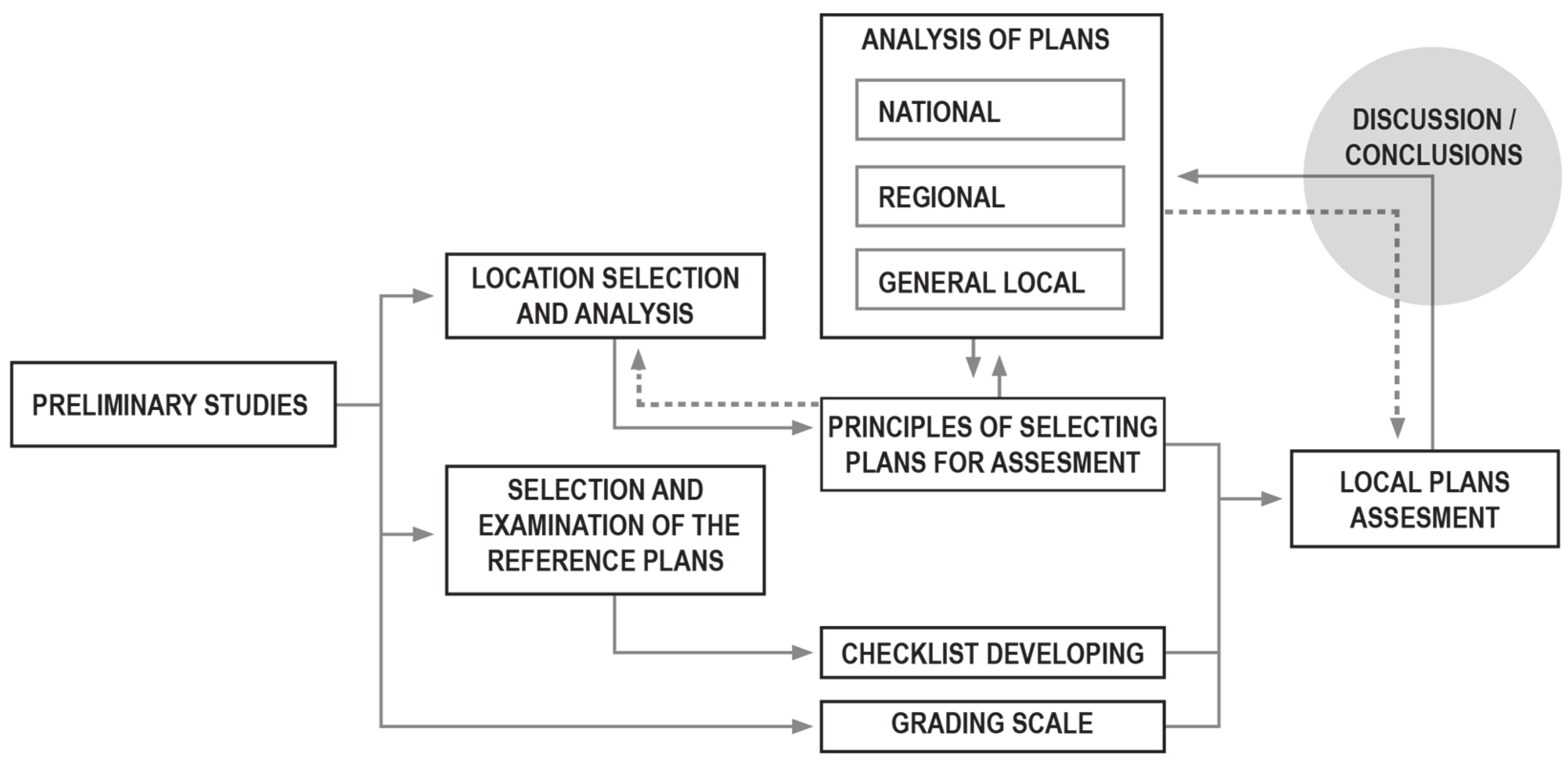
Figure 1. The outline of research workflow.
Sustainability 14 05766 g001
Figure 2. The algorithm for creating the assessment of general and local plans. The points in the black circles mean: 1. Question: do the plan takes into account the subject of water? 2. Question: do the plan properly takes into account the subject of water?
Sustainability 14 05766 g002
Figure 3. The location of the research area in Poland.
Sustainability 14 05766 g003
Figure 4. The map of areas of spatial and hydrological problems. Source: “Water and space management program”, Marshal’s Office of the Mazowieckie Voiodeship, 2016, from the author’s archive.
Sustainability 14 05766 g004
Figure 5. The map showing the location of the analyzed local spatial plans in the research area.
Sustainability 14 05766 g005
Figure 6. The Neighborhood at Bella Center II, located in Ørestad. Drawing No 8 – Handling of rainwater. Map. Source: [65].
Sustainability 14 05766 g006
Figure 7. Plan for South Czerniaków, in the Mokotów District. Map. Source: authors’ own elaboration based on: [66].
Sustainability 14 05766 g007
Figure 8. Variation in local plan component score. Left: points in a given category (A–G), compared to the maximum possible points (values 0–66). Right: as on the left, showing the scores for plans rated medium (yellow) or good (green).
Sustainability 14 05766 g008
Figure 9. Summary of the assessment of local spatial plans and general plans regarding the arrangements for the IWRM. Top: Number of local plans with a different rating (left) compared to territorially corresponding general plans, with a different rating (right). Bottom: percentage of local and general plans with different grades (colors as above).
Sustainability 14 05766 g009
Figure 10. The quality of general and local plans, shown in color on the map of the studied area.
Sustainability 14 05766 g010
Table 1. Comparison and evaluation of the quality of planning documents at various levels. For ease of reading, cells in the table are colored: green—plans rated as good, yellow—plans rated as medium, red—plans rated as bad.
National Spatial Development Concept (Assessed as Good)Spatial Development Plan for the Mazowieckie Voivodeship (Accessed as Medium)The Rate of the General Plan of the CommuneThe Rate of the Local Spatial Plan’s Provisions in Each CommuneThe Name of the Commune
Contains all the important guidelines resulting from the UE Water Framework Directive, Polish Water Law and IWM principlesThe National Spatial Development Concept was implemented in the voivodeship plan, although not all its elements were directly translated to this level.good265Leszno
good833Łomianki
medium000Czosnów
medium222Kampinos
medium312Izabelin
medium852Stare Babice
medium866Ożarów Mazowiecki
medium322Błonie
medium321Teresin
bad013Leoncin
bad253Brochów
Table 2. Comparison and evaluation of the quality of planning documents at various levels. The columns marked with the letters A–G refer to the checklist presented earlier, and the column labeled H shows the sum of the points (overall assessment).
No.The Name of the Plan Area
The Signature of Plan Resolution
ABCDEFGH
Italy
1Artegna, PGG, Rules of Implementation
C.C. 32 of 12.06.2013
022222212
2Macerata, COMMA 5, L.R. 34/1992 E SS.MM.II.02101228
Denmark
3Copenhagen, Bella Center II, Ørestad
571/2019
222222214
4Expansion of Nordhavn, Copenhagen
No. 443 with suppl. No. 1, August/2021
22210119
Latvia
5Suži, Riga
City Council Regulation No. 253 of 2 May 2017
00101114
Finland
6Change of the city plan and expansion of the southern slope
Levi, blocks 972, 974, and 976
22100016
Poland
7Warsaw, Pod Skocznią
XLII/1299/2008
222102110
8Warsaw Czerniaków South
XV/349/2019
222022212
9Zamienie, Lesznowola commune,
73/VIII/2015
22100117
10Józefosław III (1) Piaseczno commune
1286/XLIII/2018
22100117
Publisher’s Note: MDPI stays neutral with regard to jurisdictional claims in published maps and institutional affiliations.