
Application of Geoelectrical Survey and Time-Lapse Resistivity with Groundwater Data in Delineating a Groundwater Potential Map: A Case Study from Phuket Island, Thailand

 ,
, 
 and
and
Abstract
:1. Introduction
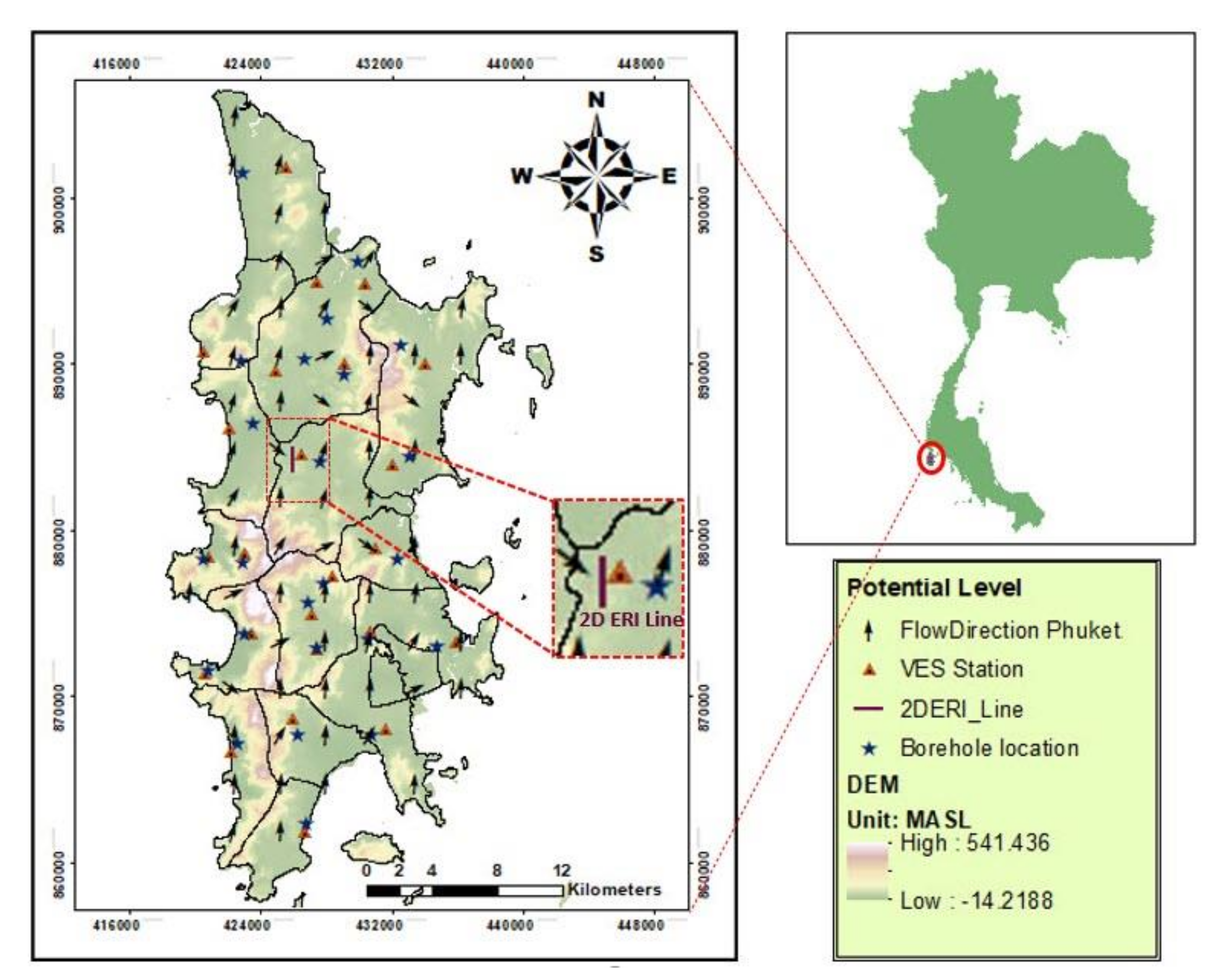
2. Site Description
3. Methods
3.1. Electrical Resistivity Survey
3.2. Delineation of Depth-of-Basement
3.3. Groundwater Potential Map Creation Using GIS Environment
3.4. Time-Lapse Electrical Resistivity
4. Results and Discussion
4.1. Groundwater Potential Based on DZP Interpretation
4.2. Groundwater Potential Based on Depth-Of-Basement and Aquifer Thickness Interpretation
4.3. Phuket Groundwater Potential
4.4. Groundwater Potential Map Validation
5. Conclusions
- Plausibly promising zones for groundwater exploration in the study area were specified.
- The time-lapse electrical resistivity imaging confirmed the groundwater potential map of Phuket. The time-lapse electrical resistivity imaging indicates no seasonal changes in the high-potential zone.
- The groundwater potential map shows that medium potential zones make up the majority of the research region (67%), with a small patch (3%) of the low-potential zone in the southeastern corner. The high-potential zones, which make up 30% of the study area, are mostly in the south-central and northeastern parts.
- The effective geoelectrical survey, which combined geological data with a time-lapse electrical resistivity approach, provided a framework for assessing groundwater potential throughout the study area.
- To gather the subsurface data, a geoelectrical survey was carried out, and the resistivity and thickness data for each layer were interpreted using the 1D EarthImager software. After that, the DZP were calculated using those data (resistivity and thickness data).
- Thematic groundwater potential maps of Dar-Zarrouk characteristics and depth-of-basement with aquifer thickness were overlaid using GIS techniques on a map of groundwater potential in the study area.
Author Contributions
Funding
Institutional Review Board Statement
Informed Consent Statement
Data Availability Statement
Acknowledgments
Conflicts of Interest
Nomenclature
| DEM | Digital Elevation Model |
| DZP | Dar-Zarrouk Parameter |
| GIS | Geographic Information System |
| GPS | Global Positioning System |
| h | The thickness of layer from resistivity model with the unit of meter |
| IDW | Inverse Distance Weighting |
| MASL | Meters Above Sea Level |
| mbgl | Meters below ground level |
| ohm-m | ohm-meter |
| RMS | Root-Mean-Square |
| S | Electrical longitudinal conductance with unit of mho |
| T | Electrical transverse resistance with unit of ohm-m2 |
| VES | Vertical Electrical Sounding |
| 2D ERI | Two-dimensional Electrical Resistivity Imaging |
| ρ | Electrical resistivity (Rho) with the unit of ohm-m |
References
- Devi, P.D.; Srinivasulu, S.; Raju, K.K. Delineation of groundwater potential zones and electrical resistivity studies for groundwater exploration. Environ. Earth Sci. 2001, 40, 1252–1264. [Google Scholar] [CrossRef]
- Gowd, S.S. Electrical resistivity surveys to delineate groundwater potential aquifers in Peddavanka watershed, Anantapur District, Andhra Pradesh, India. Environ. Earth Sci. 2004, 46, 118–131. [Google Scholar] [CrossRef]
- Anbazhagan, S.; Jothibasu, A. Geoinformatics in groundwater potential mapping and sustainable development: A case study from southern India. Hydrol. Sci. J. 2016, 61, 1109–1123. [Google Scholar] [CrossRef] [Green Version]
- Boupun, P.; Wongsai, S. Land use change and the town planning policy of Phuket. Groundwater potential modelling using GIS in Phuket province, Thailand. In Proceedings of the 33rd Asian Conference on Remote Sensing, Pattaya, Thailand, 26–30 November 2012. [Google Scholar]
- Ahmed, A.; Alrajhi, A.; Alquwaizany, A.S. Identification of Groundwater Potential Recharge Zones in Flinders Ranges, South Australia Using Remote Sensing, GIS, and MIF Techniques. Water 2021, 13, 2571. [Google Scholar] [CrossRef]
- Taweelarp, S.; Khebchareon, M.; Saenton, S. Evaluation of Groundwater potential and safe yield of heterogeneous unconsolidated Aquifers in Chiang Mai basin, Northern Thailand. Water 2021, 13, 558. [Google Scholar] [CrossRef]
- Kunkul, J.; Rojborwornwittaya, W.; Chotpantarat, S. Hydrogeologic characteristics and groundwater potentiality mapping using potential surface analysis in the Huay Sai area, Phetchaburi province, Thailand. Geosci. J. 2014, 18, 89–103. [Google Scholar] [CrossRef]
- Charoenpong, S.; Suwanprasit, C.; Thongchumnum, P. Impacts of interpolation techniques on groundwater potential modeling using GIS in Phuket province, Thailand. Groundwater potential modelling using GIS in Phuket province, Thailand. In Proceedings of the 33rd Asian Conference on Remote Sensing, Pattaya, Thailand, 26–30 November 2012. [Google Scholar]
- Ndatuwong, L.G.; Yadav, G.S. Application of geo-electrical data to evaluate groundwater potential zone and assessment of overburden protective capacity in part of Sonebhadra district, Uttar Pradesh. Environ. Earth. Sci. 2015, 73, 3655–3664. [Google Scholar] [CrossRef]
- Hasan, M.; Shang, Y.; Akhter, G.; Jin, W. Geophysical assessment of groundwater potential: A case study from mian Channu Area, Pakistan. Groundwater 2018, 56, 783–796. [Google Scholar] [CrossRef]
- Saad, R.; Nawawi, M.N.M.; Mohamad, E.T. Groundwater Detection in Alluvium Using 2-D Electrical Resistivity Tomography (ERT). Available online: https://www.researchgate.net/publication/267243392_Groundwater_Detection_in_Alluvium_Using_2-D_Electrical_Resistivity_Tomography_ERT (accessed on 1 November 2021).
- Maury, S.; Balaji, S. Geoelectrical method in the investigation of groundwater resource and related issues in Ophiolite and Flysch formations of Port Blair, Andaman Island, India. Environ. Earth. Sci. 2014, 71, 183–199. [Google Scholar] [CrossRef]
- Owen, R.J.; Gwavava, O.; Gwaze, P. Multi-electrode resistivity survey for groundwater exploration in the Harare greenstone belt, Zimbabwe. Hydrogeol. J. 2005, 14, 244–252. [Google Scholar] [CrossRef]
- Agbasi, O.E.; Edet, S.E. Hydro-geoelectric study of aquifer potential in parts of Ikot Abasi local government area, Akwa Ibom state using Electrical Sesistivity Soundings. Int. J. Geol. Earth Sci. 2016, 2, 1–15. [Google Scholar]
- Ojo, J.S.; Olorunfemi, M.O.; Akintorinwa, O.J.; Bayode, S.; Omosuyi, G.O.; Akinluyi, F.O. GIS Integrated Geomorphological, Geological and Geoelectrical Assessment of the Groundwater Potential of Akure Metropolis, Southwest Nigeria. J. Earth Sci. Geotech. Eng. 2015, 5, 85–101. [Google Scholar]
- Alabi, O.O.; Ojo, O.; Akinpelu, D.F. Geophysical Investigation for Groundwater Potential and Aquifer Protective Capacity around Osun State University (UNIOSUN) College of Health Sciences. Am. J. Water Resour. 2016, 4, 137–143. [Google Scholar] [CrossRef]
- Ebong D., E.; Akpan, A.E.; Onwuegbuche, A.A. Estimation of geohydraulic parameters from fractured shales and sandstone aquifers of Abi (Nigeria) using electrical resistivity and hydrogeologic measurements. J. Afr. Earth Sci. 2014, 96, 99–109. [Google Scholar] [CrossRef]
- Akhter, G.; Hasan, M. Determination of aquifer parameters using geoelectrical sounding and pumping test data in Khanewal District, Pakistan. Open Geosci. 2016, 8, 630–638. [Google Scholar] [CrossRef]
- Amadi, A.N.; Nwawulu, C.D.; Unuevho, C.I.; Okoye, N.O.; Okunlola, I.A.; Egharevba, N.A.; Ako, T.A.; Alkali, Y.B. Evaluation of the groundwater potential in Pompo Village, Gidan Kwano, Minna using Vertical Electrical Resistivity Sounding. Br. J. Appl. Sci. Technol. 2011, 1, 53–66. [Google Scholar] [CrossRef]
- Ali, Y.H.; Priju, C.P.; Prasad, N.B.N. Delineation of groundwater potential zones in deep midland aquifers along Bharathapuzha river basin, Kerala using geophysical methods. Aquat. Procedia 2015, 4, 1039–1046. [Google Scholar] [CrossRef]
- Puttiwongrak, A.; Ratha, M.; Sakanann, V.; Kong, S.O.; Suteerasak, T.; Nontapot, T. Groundwater Modelling for Natural Recharge Estimation in Phuket Island, Thailan. BUSCIJ 2021, in press. [Google Scholar]
- Advanced Geosciences, Inc. (AGI). Instruction Manual: Resistivity; Advanced Geoscience Inc.: Austin, TX, USA, 2016. [Google Scholar]
- Advanced Geosciences, Inc. (AGI). Instruction Manual for Earthimager1D Version 2.4.2: Resistivity and IP Inversion Software; Advanced Geoscience Inc.: Austin, TX, USA, 2014. [Google Scholar]
- Puttiwongrak, A.; Vann, S.; Rattanakom, R.; Ruamkaew, S. Preliminary assessment of seawater intrusion on Phuket Island using groundwater data analysis and Geographic Information System (GIS) Techniques. Eng. J. Res. Dev. 2019, 30, 75–88. [Google Scholar]
- Giao, P.H.; Weller, A.; Hien, D.H.; Adisornsupawat, K. An approach to construct the weathering profile in a hilly granitic terrain based on electrical imaging. J Appl Geophy 2008, 65, 30–38. [Google Scholar] [CrossRef]
- Nagarajan, M.; Singh, S. Assessment of groundwater potential zones using GIS technique. J. Indian Soc. Remote Sens 2009, 37, 69–77. [Google Scholar] [CrossRef]
- Kura, N.U.; Ramli, M.F.; Ibrahim, S.; Sulaiman, W.N.A.; Zaudi, M.A.; Aris, A.Z. A preliminary appraisal of the effect of pumping on seawater intrusion and upconing in a small tropical island using 2D resistivity technique. Sci. World J. 2014, 2014, 1–11. [Google Scholar] [CrossRef] [Green Version]
- Mailet, R. The Fundamental equations of electrical prospecting. Geophy 1974, 12, 529–556. [Google Scholar] [CrossRef]
- Carey, A.M.; Paige, G.B.; Carr, B.J.; Dogan, M. Forward modeling to investigate inversion artifacts resulting from time-lapse electrical resistivity tomography during rainfall simulations. J Appl Geophy 2017, 145, 39–49. [Google Scholar] [CrossRef]
- Vann, S.; Puttiwongrak, A.; Suteerask, T.; Koedsin, W. Delineation of Seawater Intrusion Using Geo-Electrical Survey in a Coastal Aquifer of Kamala Beach, Phuket, Thailand. Water 2020, 12, 1–14. [Google Scholar] [CrossRef] [Green Version]
- Puttiwongrak, A.; Kong, S.O.; Vann, S. Groundwater Recharge Estimation in Kathu, Phuket using Groundwater Modelling. SEAGS AGSSEA J. 2018, 49, 4–9. [Google Scholar]
- Oladapo, M.; Akintorinwa, O. Hydrogeophysical study of Ogbese South Western Nigeria. Glob. J. Pure Appl. Sci. 2007, 13, 55–61. [Google Scholar] [CrossRef] [Green Version]


| VES Station | VES Coordinates | Borehole ID | Correlation of Geo-Electric and Borehole Profile | |||||||||
|---|---|---|---|---|---|---|---|---|---|---|---|---|
| 1st Layer | 2nd Layer | 3rd Layer | ||||||||||
| UTM-X | UTM-Y | (m) | (ohm-m) | Soil Types | (ohm-m) | Soil Types | (ohm-m) | Soil Types | ||||
| VES-1 | 432031 | 883958 | BH-588 | 7.68 | 50.0 | Soil shale | 31.6 | 30 | Granite decay | N/A | 100 | Granite |
| VES-2 | 426441 | 884623 | BH-575 | 20.19 | 91.9 | Soil shale | 41.46 | 27.5 | Granite decay | N/A | 111.5 | Granite |
| VES-3 | 422078 | 886148 | BH-440 | 6.22 | 84.2 | Soil | 20.12 | 29.3 | Clay | N/A | 100.3 | Clayey rock |
| VES-4 | 420563 | 890834 | BH-453 | 6.73 | 81.9 | Soil shale | 20.87 | 40.3 | Granite decay | N/A | 114.2 | Granite |
| VES-5 | 424905 | 889617 | BH-571 | 10.68 | 140.8 | Soil | 12.79 | 100.2 | Weather rock | N/A | 303.2 | Granite |
| VES-6 | 429157 | 890042 | BH-595 | 16.93 | 128.4 | Soil shale | 39.02 | 100.4 | Granite decay | N/A | 247.9 | Granite |
| VES-7 | 434078 | 890005 | BH-770 | 8.83 | 145.5 | Soil shale | 15.62 | 101.3 | Granite decay | N/A | 240.9 | Granite |
| VES-8 | 430386 | 894824 | BH-698 | 4.93 | 57.5 | Soil shale | 23 | 19.9 | Granite decay | N/A | 98.5 | Granite |
| VES-9 | 427470 | 894941 | BH-496 | 5.98 | 80.6 | Soil | 33.39 | 44.2 | Clay | N/A | 193.7 | Weathered Rock |
| VES-10 | 425533 | 901940 | BH-586 | 5.32 | 63.1 | Soil | 14.56 | 53.5 | Clay | 17.48 | 23.5 | Clayey sand |
| VES-11 | 426708 | 861838 | BH-665 | 4.04 | 144.9 | Soil | 6.84 | 45.5 | Sticky soil | 11.86 | 136.6 | Clayey sand |
| VES-12 | 425957 | 868701 | BH-755 | 12.67 | 92.3 | Soil | 13.75 | 52.8 | Clayey sand | 12.26 | 49.4 | Weathered Rock |
| VES-13 | 422216 | 866712 | BH-616 | 29.15 | 139.4 | Soil shale | 15.13 | 48.7 | Granite decay | N/A | 342.4 | Hard Granite |
| VES-14 | 431614 | 868061 | BH-614 | 19.37 | 138.1 | Soil | 21.14 | 53.3 | Weather rock | N/A | 374.2 | Granite |
| VES-15 | 435927 | 873251 | BH-168 | 14.49 | 2.5 | Stone decay | N/A | 221.3 | Hard granite | N/A | N/A | N/A |
| VES-16 | 430728 | 873934 | BH-359 | 12.12 | 172.6 | Soil | N/A | 100.4 | Granite decay | N/A | N/A | N/A |
| VES-17 | 430982 | 878905 | BH-710 | 5.87 | 96.0 | Soil | 28.99 | 43.5 | Fractured rock | N/A | 191.1 | Granite |
| VES-18 | 420825 | 878440 | BH-498 | 11.81 | 56.5 | Soil | 13.38 | 14.7 | Granite decay | N/A | 271.7 | Hard Granite |
| VES-19 | 423061 | 878654 | BH-738 | 20.33 | 114.5 | Soil shale | N/A | 200.2 | Granite decay | N/A | N/A | N/A |
| VES-20 | 428337 | 877270 | BH-650 | 6.75 | 160.1 | Benthic | 5.2 | 59.7 | Clayey sand | 13.81 | 25.3 | Weathered Rock |
| VES-21 | 423468 | 873838 | BH-255 | 10.13 | 61.8 | Clay | 8.01 | 21.8 | Fractured rock | N/A | 195.5 | Granite |
| VES-22 | 427071 | 875008 | BH-220 | 27.23 | 134.1 | Benthic | 7.19 | 100.5 | Granite decay | N/A | 214.5 | Granite |
| VES-23 | 420668 | 871425 | BH-495 | 10.41 | 107.5 | Soil | 39.81 | 15.6 | Weather rock | N/A | 181.5 | Hard Granite |
| VES-24 | 427417 | 872842 | BH-682 | 12.83 | 210.3 | Soil | N/A | 100.4 | Weather rock | N/A | N/A | N/A |
| Longitudinal Conductance (mho) | Protective Capacity Rating |
|---|---|
| >10 | Excellent |
| 5 to 10 | Very good |
| 0.7 to 4.9 | Good |
| 0.2 to 0.69 | Moderate |
| 0.1 to 0.19 | Weak |
| <0.1 | Poor |
Publisher’s Note: MDPI stays neutral with regard to jurisdictional claims in published maps and institutional affiliations. |
© 2021 by the authors. Licensee MDPI, Basel, Switzerland. This article is an open access article distributed under the terms and conditions of the Creative Commons Attribution (CC BY) license (https://creativecommons.org/licenses/by/4.0/).
Share and Cite
Puttiwongrak, A.; Men, R.; Vann, S.; Hashimoto, K.; Suteerasak, T. Application of Geoelectrical Survey and Time-Lapse Resistivity with Groundwater Data in Delineating a Groundwater Potential Map: A Case Study from Phuket Island, Thailand. Sustainability 2022, 14, 397. https://doi.org/10.3390/su14010397
Puttiwongrak A, Men R, Vann S, Hashimoto K, Suteerasak T. Application of Geoelectrical Survey and Time-Lapse Resistivity with Groundwater Data in Delineating a Groundwater Potential Map: A Case Study from Phuket Island, Thailand. Sustainability. 2022; 14(1):397. https://doi.org/10.3390/su14010397
Chicago/Turabian StylePuttiwongrak, Avirut, Ratha Men, Sakanann Vann, Kiyota Hashimoto, and Thongchai Suteerasak. 2022. "Application of Geoelectrical Survey and Time-Lapse Resistivity with Groundwater Data in Delineating a Groundwater Potential Map: A Case Study from Phuket Island, Thailand" Sustainability 14, no. 1: 397. https://doi.org/10.3390/su14010397
APA StylePuttiwongrak, A., Men, R., Vann, S., Hashimoto, K., & Suteerasak, T. (2022). Application of Geoelectrical Survey and Time-Lapse Resistivity with Groundwater Data in Delineating a Groundwater Potential Map: A Case Study from Phuket Island, Thailand. Sustainability, 14(1), 397. https://doi.org/10.3390/su14010397