Abstract
The urban flooding situations have arisen in the modern scenario of urbanization due to climatic changes. This work contributes to designing a planned and feasible urban rain flood ecosystem to promote the construction of a sponge city. It has various advantages of improving the water environment, controlling urban waterlogging, reducing runoff pollution, improving river and lake water quality, recycling rainwater resources, replenishing groundwater, and many more. This paper combines the design methods and advantages of the design results formed in decades using traditional regulation and utilizing it for the present study. It reconstructs and integrates the traditional regulation and sponge city construction requirements, thereby providing a feasible urban rain-flood ecosystem in the industrial and smart city scenario. Finally, the regulation of new paddy areas in Yanjin city of China is considered for experimentation, and the design of the regulation is applied using this setup. The design results obtained from the test of sponge city construction have operability and can improve the urban environment and enhance the vitality of the city. The control plan’s design results integrating the sponge city idea can provide effective technical support and guarantee the overall urban environment. The work presented in this article can assess and plan the flood mitigation measures to monitor this type of situation leading to flooding risk reduction in smart cities.
1. Introduction
Over the last few decades, various countries worldwide have faced the issues due to increased urbanization. Majorly, the two countries China [1,2] and UK [3] have witnessed a steep increase in the urbanization rate, which is expected to rise following a similar trend by the end of the 21st century [4]. This urbanization has a great impact on modern civilization leading to the increased need for urban development. The adverse effects of urbanization have been reported in various urban hydrological literature, which points out the requirement of proper planning and channelizing the feasibility of the urban rain flood ecosystem [5,6]. This increased the need for more systematized water resources which should be routinely modified or replaced with the proper drainage channels due to increasing buildings and pavements.
Climatic change and global warming are the two significant phenomena affecting the global situation of various countries. There are several major examples of climatic change’s adverse effects in different parts of the world [7]. The flooding situation in some major parts of China is worse as the millions of people who live in the area are at a noteworthy risk of flooding [8]. Additionally, heavy rainfall in Ethiopia (which is the Nile River’s major source) has adverse effects on Egypt’s agricultural outcome [9]. These climatic changes have led to the rising demand for food, water, and energy resources worldwide [10,11]. Thus, a systematic approach involves both the interdisciplinary and transdisciplinary research initiatives to deal with the complex challenges [12,13]. The challenges lied in the lack of human expertise to deal with the climatic changes, inadequate human resources, low budget, and less autonomy in risk management due to government authorities’ dependence [14,15].
The risk management process for identifying flood situations and taking the coordinative steps for its treatment plays a great role in planning and decision making. According to the International Organization for Standardization (ISO), risk management is the process of taking the coordinative measures for the direction and controlling of an organization regarding a risk factor [16]. This process is depicted in Figure 1, which is regarded as an iterative phenomenon to improve and protect an organization’s value chain.
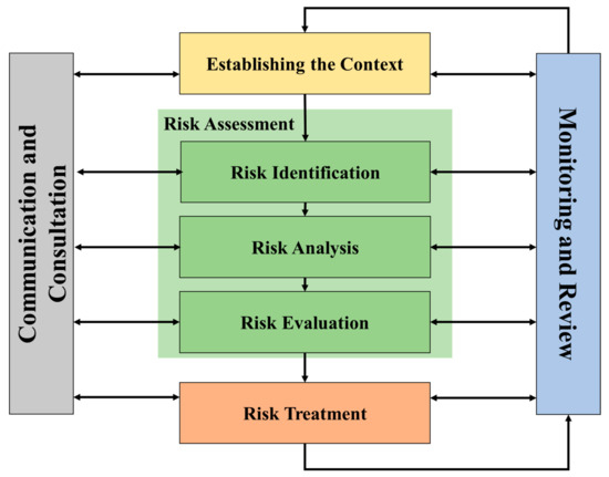
Figure 1.
Risk management guidelines provided by ISO [16].
Risk management is applicable for specific sectors. Various contexts are to be established before processing risk assessment like particular needs, the perception, and criteria considerations, etc. The risk assessment state involves its identification, evaluation, and treatment. The risk management guidelines provided by ISO also focus on the importance of communication and monitoring the status to review the entire process.
Urban water challenges like flooding and poor drainage systems have adversely affected the Chinese cities as well in the recent years of swift urbanization. Complexity arises in some parts of China, as various casualties have occurred due to the high-intensity flash floods causing the downward turn of economy and fatalities across China [17]. With the acceleration of urbanization [18] in China, a large number of people are migrating into cities. This has led to new urban areas that need more water resources and a better water environment to meet the needs of production and life. Since the construction of old urban areas in China has basically ended, the sponge city’s concept can have sufficient time to consider the construction of various green infrastructure [19,20,21]. The urban new district construction achievements of regulatory approval often cannot keep up with the new city construction step. In practice, there is always a new city construction site elevation position of the first set of good roads. Some construction land determines the nature and construction of the back gauge control design unit and results from the drawing phenomenon. This situation makes the statutory planning out of control and guidance of the new district’s construction, leading to the city’s new district construction variability, too [22,23,24].
Therefore, the special planning requirements of sponge city should be incorporated into the regulatory planning results so that the content of the special planning of sponge city can be accurately implemented through the qualitative and quantitative advantages of regulatory planning. A set of regulatory planning results can guide the normal construction of the new area and realize the purpose of sponge city.
This work contributed to putting forward the suitability for sponge key design strategy of city constructions, the total content and regulatory rules in the content integration, combining the characteristics of all kinds of the new city district. This article aims at critically reviewing the management practices being adopted, particularly in Yanjin city China. A planned and feasible urban rain flood ecosystem is designed to promote the construction of sponge city, improve the water environment, control urban waterlogging, reduce runoff pollution, improve river and lake water quality, recycle rainwater resources, replenish groundwater, etc. The traditional regulation and sponge city construction are reconstructed and integrated into this work to provide a feasible urban rain flood ecosystem in the industrial and smart city scenario. Yanjin city of China is considered for experimentation. It was found that the sponge city construction has operability and can also improve the urban environment and enhance the vitality of the city. This research is viable to evaluate and plan the flood mitigation measures to monitor and reduce the situation accounting for flood risks in the smart cities.
The rest of this article has been arranged as: Section 2 presents the literature review of the urban rain flood designing modules in the state-of-the-art approaches. The urban rain flood ecosystem design framework is depicted in Section 3, highlighting various design and planning criteria. Section 4 provides the empirical analysis of the proposed urban rain flood ecosystem design considering Yanjin paddy field’s new area of China, as an example, followed by concluding remarks in Section 5.
2. Literature Review
In recent years, there have been many types of research on urban construction of urban rain flood sponges. Authors in [25] provided a lateral study emphasizing the rain flood management process in the developing countries and summarize the foreign rain flood management system periodically. The process of development and evolution, the governance model of comprehensive, space features of regional convergence, and deep form of urban development system analyzes the reason for combining this study with the practical situation of China’s cities. They also presented the future urban rain flood management method, which can lead to the development in the direction of thinking and can use the history of exploration to assist the future multi-scale hydrological conditions in the rain flood damage. The authors in [26] analyzed the practice of sponge city concept in utilizing rain and flood resources. They put forward the relative opinions and suggestions on the construction mechanism and development in the main city. The authors put forward the multi-factor analysis and integration process under a complicated rain forest environment to act as a research and development plan in smart city planning. Authors in [27] analyze the generally-used at the rain flood management measures, and summarize its advantages and disadvantages in China to put forward the background of “sponge city”. The analysis of ancient Chinese in the aspect of management of water resources problem draws the lessons from a foreign successful case, and presented a more reasonable and comprehensive solution to the problem of the urban flood waterlogging. The urban water system’s overall planning, the green, is combined with all kinds of rain flood management facilities to assure urban water safety and reduce pollution, prevention, and control of waterlogging. However, most of the above literature is theoretical summaries, and few of them mention practical planning strategies [28].
Aiming at the problem of urban rainwater management, the authors took Wanling Mountain in Jinan city as the research object and conducted landscape planning and design research of the urban mountain park based on the concept of sponge city [29]. The theory and method of planning and design of mountain parks with sponge concepts are studied. By comparing and analyzing the research progress and methods of rainwater resource utilization at home and abroad, and taking sponge city theory, Low Impact Development (LID) theory, urban ecology theory, as well as other related theories as the support, the planning, and design of urban mountain park with sponge city concept, are systematically studied.
The sponge city program was initiated in 2013 as a sustainable urban development means in China [30]. China’s central government put forward this initiation, and the guidelines were formulated for the construction of sponge city in the urban areas [31]. In 2015, many sponge cities were selected and evaluated for the examination of trial construction [32]. More sponge cities were selected from the year 2016–2017 to prepare the smart cities for urban planning [33]. In the year 2018, the Chinese government published the assessment standard for sponge city management, which can use the concept of sponge absorption for water management in China [34].
The resilience concept came into the picture in the previous decades for climate change adaptation in the urban scenario [35,36,37]. Authors in [38] considered urban climate resilience’s main aspects, such as systems and the agents. Even during the different climatic changes, the flexible operation of urban cities was considered in the resilient urban systems. The action plan and strategies related to resilience require cooperation among various sectors of society [38]. The researchers’ various steps include process setup, assessment of existing knowledge of risk, and identifying potential adaptation choices, choosing among them the designing, implementing, and evaluating of the outcomes [39,40]. The assessment of urban resilience was done by the authors [41,42] to assess the water management process in recent years, despite the lack of integration frameworks.
This article studies the design and objective evaluation of rainwater management facilities of famous landscape planning and design cases at home and abroad. It analyzes the advantages and disadvantages of existing mountain park sponge facilities through field research. It summarizes the objectives, principles and methods of urban mountain park landscape planning and the sponge city concept. According to the needs of urban rain flood construction, this article reconstructs traditional control planning content. It improves the method system of sponge city control planning by putting forward the urban rain flood ecosystem. It analyzes the key points of sponge city control planning-level design strategy corresponding to various new urban areas. Furthermore, it makes the new urban area that achieves the expected purpose of sponge city construction.
3. Materials and Methods
3.1. Urban Rain Flood Ecosystem Design
There are various factors determining the urban rain flood ecosystem design in the modern city scenario, like the waterfront environment, road section designing, and planning and design of rain and sewage engineering. The schematic design of the urban rain flood ecosystem is presented in Figure 2, which fulfills all the design parameters.
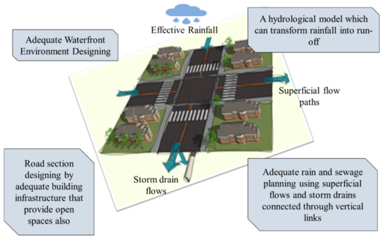
Figure 2.
Schematic design of urban rain flood ecosystem in smart cities.
The complete design requirements and the techniques are elaborated in the following sections discussing various aspects of design considerations, analyzing the current scenario.
3.2. Waterfront Environment Design
Nowadays, an urban water bank is basically to compress the width of the river and the width of the greenbelt along the river as much as possible under the condition of ensuring flood control, so the general situation of water bank is vertical or slope hard embankment, and narrow belt greenbelt along the coast. In terms of function, citizens only have functions such as walking and having a rest in the green space, and there are few squares and other places that can accommodate citizens for group entertainment activities. The vertical type and slope type hard revetment built on both sides of the riverbank is too steep to set up footpaths close to the water surface, resulting in citizens’ inability to kiss the water. In terms of quality, the land along the water body is developed and constructed, squeezing the water body’s living space and gradually reducing the green water area in the city. Even if there is open space, it is artificial squares and paving, and the environmental quality is too rigid [29,43]. The analysis of the current situation of urban waterfront environment is discussed in Table 1 along with the content which is needed to be improved.

Table 1.
Analysis of the current situation of urban waterfront environment.
Integrate the control planning design unit’s control ability in sponge city and the water conservancy design unit’s professional technology in water conservancy projects, and let the water conservancy design unit and the control planning design unit work together. The steps are as follows:
- Calculate the water conservancy design unit’s elevation of normal water level and calculate the elevation of flood level according to the flood control standard [30,44].
- The control planning design unit designs the embankment form and preliminarily determines the horizontal distance between the flood level elevation position. The level elevation of the normal water level is according to the space required by the ecological gentle slope green space.
- Submit the obtained cross-section map of water body green space to the water conservancy design unit to calculate again accurately whether it can meet the flood control requirements.
- The regulatory design unit shall make the corresponding regulatory design results after obtaining the cross-sectional map of green water space verified by the water conservancy design unit.
3.3. Road Section Design
The traditional road section design is satisfied in the vehicle, non-motor vehicle, pedestrian, and green space. For the sake of traffic safety, motor vehicles and non-motor vehicles are separated by a green belt or guardrail. The sidewalk will be about 20 cm higher than the road surface to protect pedestrian safety [44,45]. The green space also has an independent range without interference. The ratio of green space area to road area will be appropriately increased in areas where vegetation is suitable for growth or in consideration of garden city needs and city image of landscape avenue. Therefore, this part of green space is distributed in the form of a point-like tree pool, banded tree pool, banded road isolation green belt, and a green street belt.
Suppose the collected rainwater is injected into the rain-pipe outlet and drained away by only relying on the rainy season’s road surface. In that case, there will be LID facilities to collect the rainwater that cannot be retained and enter the rain-pipe network. Therefore, this paper proposes to implement a stratified drainage strategy. It is divided into three levels of drainage: high, medium, and low, such as commercial hard surface, permeable pavement, and sunken green land. It is suggested that the rainwater collected from the public buildings along the road and the hard squares along the street be dissolved internally. It can be constructed in the form of a sunken rain garden or green space. Considering the needs of plant growth, the depth should not exceed 150 mm, and it needs to be coordinated with LID facilities in various construction lands connected with the road [45,46,47,48]. Rainwater within the red line of the road can be filtered down by permeable materials laid on the road surface and then transferred to the sunken green land along the road. The rainwater that cannot be transferred through the pavement’s infiltration material can be collected through the surface into the biological retention pool along the side, the sunken tree pool, and the shallow grass ditch for retention and purification. When the stagnant rainfall exceeds the predetermined depth, it will turn into the urban rainwater pipe network through the overflow port. In this way, part of the rainfall can be dissolved. The rainfall on the surface of green land will be directly detained within the scope of green land, and overflow mouth or overflow pipe will be injected into the urban rainwater pipe network after exceeding the limit.
3.4. Planning and Design of Rain and Sewage Engineering
We took the method of rainwater recycling, collect rainwater, which can play the following role.
- (1)
- Collect rainwater within the planning scope, which can be used for indoor cleaning, road spraying, plant watering, and other purposes, reducing tap water use, saving water resources, and urban operating costs.
- (2)
- Retention of rainwater can provide enough time for plant roots to absorb water, and when plants have enough water, they can increase water vapor transpiration and reduce the harm of heat island effect [49,50,51]. Simultaneously, rainwater retention time is long, can permeate to the ground, supplement groundwater, and maintain the same groundwater level.
- (3)
- When rainwater flows through plants’ surface, pollutants such as nutrient-rich compounds contained in rainwater can be decomposed and purified by plants and microorganisms. In this way, even if excessive rainfall is required to transfer excess rainfall to large reservoirs or rivers, the surface and groundwater environment will not be polluted. Table 2 provides the comparative analysis of the effect of rainwater fast drainage model and rainwater recycling model.
Table 2. Comparison of the effect of rainwater fast drainage model and rainwater recycling model.
In order to realize the effective retention, purification, recovery, and infiltration of rainwater, different levels of green infrastructure should be built in the planning of controlled rainwater project, and the rainwater engineering system should be built together with urban rainwater pipe network.
- (1)
- In the case of low-intensity rainfall, all rainwater will be captured by the green roof, sunken green land, permeable pavement, storage tank, water storage tank, and other small green infrastructure at the source (i.e., each plot), which does not need to be reflected in the rainwater project planning.
- (2)
- In the case of moderate rainfall, some rainwater will still flow out after interception at the source, which can be completely intercepted by storage tanks and small lakes set up in various public green spaces and protective green spaces in the city [52,53].
- (3)
- In the case of high-intensity rainfall and ultra-high-intensity rainfall, large natural and artificial water storage sites should be set up. Still, the connection between water storage sites and urban rainwater pipe networks should also be set up and be established. The chestnut pumping stations should be set up to pump excess rainwater into rivers in time. To change the way of centralized transportation of all domestic sewage through a sewage pipe network to the sewage treatment plant for treatment, a sewage treatment plant can be configured according to the way of division of residential areas. The treated water will be discharged into the adjacent ecological green space for purification and storage, which will be used for road spraying and landscaping irrigation.
4. Results and Discussion
In order to test the rationality of the control plan design strategy in the control plan design of the new district of sponge city, the paper chooses the control plan project of the new district of paddy field in Yanjin city as an example. The empirical analysis is done to verify the presented urban rain flood ecosystem design for smart cities.
4.1. Catchment Area and Runoff Control for Smart Cities
The total amount of stormwater runoff control in the catchment area includes the total amount of stormwater runoff control in the construction land and non-construction land of the smart cities, not less than 80%. Public storage facilities can accommodate 20% of the rainwater that still overflows after being stored in LID facilities. By controlling the total amount of rainwater runoff and the capacity of public storage facilities in various areas, the annual rainfall of 25.5 mm can be controlled by 80% to 100%, ensure the control of the river water in paddy fields after the development of new paddy fields, and ensure the storage and use of rainwater and flood control.
In order to prevent the stored water contamination, the runoff should be diverted during the rainfall, and a greater number of catchment areas should be used for this incorporation. Each catchment area shall meet the construction requirements in Figure 3 and Figure 4 and implement unit control [54].
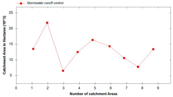
Figure 3.
Stormwater runoff control in the catchment area.
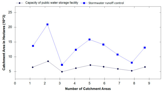
Figure 4.
Comparative analysis of total runoff control and capacity of public water storage facilities in catchment areas.
Figure 3 depicts stormwater runoff control in the catchment area (in hectares) with respect to the number of catchment areas. This figure reveals that more catchment area is required if the number is less to control the stormwater runoff; however, if we increase the number of catchments, the less area can control the runoff stormwater. A comparison is presented in Figure 4 that reveals the stormwater runoff control in total compared with the capacity of public water storage facilities in the catchment area.
This figure depicts both the capacity of the public water storage facility and stormwater runoff control requirements. Both the graphs follow the same trend. The increasing number of catchment areas improves public water storage capacity and controls the stormwater runoff in a better manner. While considering the smaller number of catchments, the increased capacity of public water storage and stormwater runoff control are accountable for increased catchment area in hectares.
From the year 2000 to 2020, the complete scenario of rainfall (in mm), actual direct runoff (in mm) and the total runoff (in m3) is studied and depicted in Figure 5.
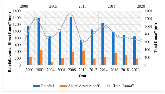
Figure 5.
Scenario of rainfall, actual direct runoff and the total runoff from year 2000 to 2020.
The total amount of stormwater runoff is the next target of LID facilities for all land in the catchment area. The paper puts forward corresponding control requirements for each type of land use, as shown in Table 3.
Table 3.
List of LID control indexes in paddy field’s new district (%).
The LID facilities are dedicated to the stormwater runoff control, sunken green rate, green roof and permeable pavement rate for all the land types like residential land, public administration land, public service facilities, commercial service lands, municipal roads, utility land, green space and square land.
4.2. Road Traffic Planning for Smart Cities
The real-time traffic condition of smart cities is improved by using sustainable road traffic planning strategies. The advanced traffic management systems develop the traffic mitigation methodologies to enable a better city environment by improving the existing traffic platforms. The complete layout of the road traffic planning system for smart cities is indicated in Figure 6.
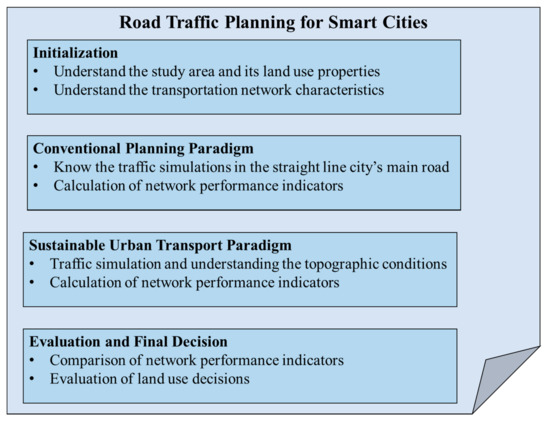
Figure 6.
Layout of road traffic planning for smart cities.
In addition to the straight line of the city’s main road, the rest of the roads are designed in accordance with the mountain terrain. The width of the main road is 24 m, the width of the secondary road is 12–15 m, and the width of the branch road is 10 m.
The vertical design of roads in mountain cities gives priority to the whole urban area’s topographic conditions. The paddy field’s overall terrain condition is high and steep on both sides and gentle in the middle, so the road is designed vertically along the terrain without destroying the topography and green vegetation. As the sewage project planning and rainwater project planning should be in the form of self-weight transfer, the design should be carried out based on the vertical planning of roads in mountain cities, so the sewage treatment facilities and public water storage facilities are located at the bottom of the valley, in the lower position of the vertical elevation of roads. Besides, the red line width of the road in mountain cities is greatly restricted by topography. Therefore, the design of the green isolation belt is canceled. The purpose of sponge city construction is to make full use of natural greening to control rainwater runoff and reduce rainwater pollution. Therefore, the construction’s key contents are the sunken tree pond, grass ditch along the side, rain garden, the permeable pavement of the sidewalk, and the overflow facilities connecting the road with grass ditch along the side, rain garden and so on. Moreover, due to the shortage of funds for the construction of the new area and the good foundation of the green environment of the new area of the paddy field, therefore, no permeable materials are used for laying motor vehicle and non-motor lanes.
4.3. Rainwater Project Planning for Smart Cities
Multiple factors should be considered for rainwater harvesting and the management of water flow in smart cities. These factors include the optimal utilization of existing resources, anticipation of future demand, and analysis of the impact of climatic changes over the approaching years. The design of rainwater project planning for rainwater harvesting in the smart cities is depicted in Figure 7.
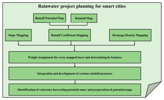
Figure 7.
Design considerations for rainwater project planning for smart cities.
The design specifications given in Figure 7 are considered for the development of smart cities and thereby indulging better rainwater project planning. Compared with the traditional rainwater control plan, the presented rainwater project in the Shuitian new district includes a rainwater pipe network, public storage facilities, and excess rainwater discharge. The mountain rainfall flows through the interception channel to the channel or road, planting grass along the side of the ditch. When the capacity of rain flood passage and grass planting ditch reaches saturation, it is transferred to the urban rainwater pipe network through the overflow pipe and transferred to public water storage facilities. If the rainfall is too large, the excess rainwater will be discharged from the public storage facilities or directly open the excess discharge port to discharge the rainwater into the paddy river. LID facilities and standard storage facilities reduce rainfall. Excess rainwater is transferred from the rainwater pipe network to public storage facilities.
4.4. Sewage Engineering Planning for Smart Cities
An effective sewage management system plays a vital role in the establishment of a smart city. The sewage planning is accomplished by initially performing the screening process, then categorizing the sewage into grit chambers, followed by its passage to the skimming and sedimentation tank prior to processing it in the treatment plant. Figure 8 depicts sewage engineering planning for smart city designing of an urban rain flood ecosystem.
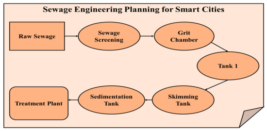
Figure 8.
Flow diagram of sewage engineering planning for smart cities.
The calculation of sewage quantity in the new area of the paddy field is determined by multiplying the sewage discharge coefficient. The maximum daily water supply is 17,000 cubic meters per day, and the sewage discharge coefficient is 0.8. Maximum daily sewage discharge Q = 17,000*X(0.8) = 13,600 cubic meters/day. Considering the needs of urban development, the scale of sewage treatment plants will be slightly expanded. It is planned to divide the paddy field’s new area into three sewage treatment zones, each of which is equipped with a sewage treatment plant. The sewage treatment plant will be equipped with a wetland or pond as a storage site for purified water in addition to the necessary treatment facilities. It is then transported to the riverside green land side by the reclaimed water system as the water for urban road cleaning and landscaping.
The entire scenario of development for urban rain flood ecosystem design and planning in smart cities is depicted in Figure 9. This indicates the development graph revealed from various literatures from the year 2000 to 2020 in the field of urban rain flood ecosystem development and planning. The outcomes obtained by the survey indicates that the exploratory development is seen between the period 2000 to 2005 which is followed by the initial development between the year 2006 to 2009 and rapid development can be seen from the graph of year 2010 to 2020.
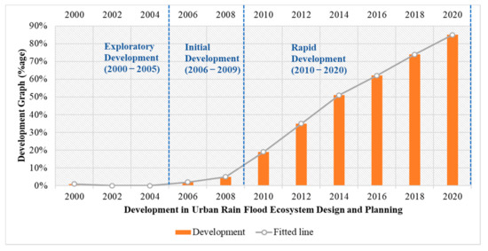
Figure 9.
Development scenario for urban rain flood ecosystem design and planning for smart cities.
Using the design specification proposed in this work, a new paradigm can be achieved for the rapid development of urban rain flood ecosystem design and planning in smart cities.
5. Conclusions
This paper combines the various methods and advantages of the design results formed in decades by the traditional regulation and utilizes it for the present study. It reconstructs and integrates the traditional regulation and sponge and smart city construction requirements and then develops an urban rain flood ecosystem. The regulation of new paddy areas in Yanjin city of China is considered for experimentation, and the regulation design is applied. It is found that the design results of the control plan integrating the sponge city idea can provide effective technical support and guarantees the overall urban environment and urban vitality. The various contributions of this article are concluded as the following.
This work presents a reasonable arrangement for citizens’ activities according to different flood levels so that the city avoids the threat of floods. The experimentation reveals that the considered river banks become ecological revetments, and the green belt along the river is higher than the flood line. Gentle slope green belt provides more opportunities for plants to contact the water body and enables citizens to get close to the river through footpaths and steps.
This article enables the flexible controlling LID indicators and unit management and rainwater runoff control in catchwater districts. This allows government managers to adapt to the characteristics of fast construction and changeable projects in new urban areas and improve urban operation efficiency.
The change in road drainage ensures that the city has enough urban road area unchanged, runoff pollution can be effectively reduced, and rainwater runoff can be controlled. Combined with LID facilities in various construction plots, urban waterlogging risk can be effectively controlled.
Compared with centralized treatment, the sewage treatment facilities utilized in this article reveal that the sewage pipe diameter in most sections is smaller. The sewage pipe network laying cost is lower, and the nearby purification treatment and on-site recycling can be achieved.
This work can mitigate the flood occurrence measures and is capable of monitoring the situation leading to flooding risk reduction in smart cities.
Author Contributions
Conceptualization, Y.Z. and A.S.; methodology, M.M.; software, G.S.G.; validation, G.D., and K.Z.G.; formal analysis, M.A.A.; investigation, Y.Z.; resources, Y.Z.; data curation, Y.Z.; writing—original draft preparation, Y.Z.; writing—review and editing, Y.Z.; visualization, Y.Z.; supervision, M.A.A.; project administration, M.A.A.; funding acquisition, A.S. All authors have read and agreed to the published version of the manuscript.
Funding
Taif University Researchers’ Supporting Project, number (TURSP-2020/98), Taif University, Taif, Saudi Arabia.
Institutional Review Board Statement
Not applicable.
Informed Consent Statement
Not applicable.
Data Availability Statement
All data discussed in the main manuscript.
Acknowledgments
Authors would like to thank for the support of Taif University Researchers’ Supporting Project, number (TURSP-2020/98), Taif University, Taif, Saudi Arabia.
Conflicts of Interest
The authors declare no conflict of interest.
References
- Hubacek, K.; Guan, D.; Barrett, J.; Wiedmann, T. Environmental implications of urbanization and lifestyle change in China: Econological and water footprints. J. Clean. Prod. 2009, 17, 1241–1248. [Google Scholar] [CrossRef]
- Chen, Q.; Song, Z. Accounting for China’s urbanization. China Econ. Rev. 2014, 30, 485–494. [Google Scholar] [CrossRef]
- Office for National Statistics. 2011 Census Analysis: Comparing Rural and Urban Areas of England and Wales; The Stationery Office Ltd.: London, UK, 2013.
- United Nations Department of Economics and Social Affairs/Population Division (UNDESA/PD). World Population Prospects: The 2017 Revision, Key Findings and Advance Tables; UNDESA/PD: New York, NY, USA, 2017. [Google Scholar]
- Eshtawi, T.; Evers, M.; Tischbein, B. Quantifying the impact of urban area expansion on groundwater recharge and surface runoff. Hydrol. Sci. J. 2015, 61, 826–843. [Google Scholar] [CrossRef]
- Xu, Z.; Zhao, G. Impact of urbanization on rainfall-runoff processes: Case study in the Liangshui River Basin in Beijing, China. In Proceedings of the International Association of Hydrological Sciences; Copernicus GmbH: Goettingen, Germany, 2016; Volume 373, pp. 7–12. [Google Scholar]
- Özerol, G.; Dolman, N.; Bormann, H.; Bressers, H.; Lulofs, K.; Böge, M. Urban water management and climate change adaptation: A self-assessment study by seven midsize cities in the North Sea Region. Sustain. Cities Soc. 2020, 55, 102066. [Google Scholar] [CrossRef]
- Miao, L.; Zhu, F.; Sun, Z.; Moore, J.C.; Cui, X. China’s Land-Use Changes during the Past 300 Years: A Historical Perspective. Int. J. Environ. Res. Public Health 2016, 13, 847. [Google Scholar] [CrossRef]
- Borowski, P.F. Nexus between water, energy, food and climate change as challenges facing the modern global, European and Polish economy. AIMS Geosci. 2020, 6, 397–421. [Google Scholar] [CrossRef]
- Zhang, Q.; Xu, C.-Y.; Tao, H.; Jiang, T.; Chen, Y.D. Climate changes and their impacts on water resources in the arid regions: A case study of the Tarim River basin, China. Stoch. Environ. Res. Risk Assess. 2009, 24, 349–358. [Google Scholar] [CrossRef]
- Kling, C.L.; Arritt, R.W.; Calhoun, G.; Keiser, D.A. Integrated Assessment Models of the Food, Energy, and Water Nexus: A Review and an Outline of Research Needs. Annu. Rev. Resour. Econ. 2017, 9, 143–163. [Google Scholar] [CrossRef]
- Avraamidou, S.; Beykal, B.; Pistikopoulos, I.P.; Pistikopoulos, E.N. A hierarchical Food-Energy-Water Nexus (FEW-N) decision-making approach for Land Use Optimization. In Computer Aided Chemical Engineering; Elsevier: Amsterdam, The Netherlands, 2018; Volume 44, pp. 1885–1890. [Google Scholar]
- Karnib, A.; Alameh, A. Technology-oriented approach to quantitative assessment of water–energy–food nexus. Int. J. Energy Water Resour. 2020, 4, 189–197. [Google Scholar] [CrossRef]
- Owa, F. Water Pollution: Sources, Effects, Control and Management. Mediterr. J. Soc. Sci. 2013, 4, 65. [Google Scholar] [CrossRef]
- Borowski, P.F. Environmental pollution as a threats to the ecology and development in Guinea Conakry. Ochr. Srodowiska Zasobów Nat. 2017, 28, 27–32. [Google Scholar] [CrossRef][Green Version]
- ISO 31000:2018 Risk Management—Guidelines; ISO: Geneva, Switzerland, 2018.
- Jiang, Y.; Zevenbergen, C.; Ma, Y. Urban pluvial flooding and stormwater management: A contemporary review of China’s challenges and “sponge cities” strategy. Environ. Sci. Policy 2018, 80, 132–143. [Google Scholar] [CrossRef]
- Dhiman, G.; Oliva, D.; Kaur, A.; Singh, K.K.; Vimal, S.; Sharma, A.; Cengiz, K. BEPO: A novel binary emperor penguin optimizer for automatic feature selection. Knowl. Based Syst. 2021, 211, 106560. [Google Scholar] [CrossRef]
- Augustine, D.J.; McNaughton, S.J. Interactive Effects of Ungulate Herbivores, Soil Fertility, and Variable Rainfall on Ecosystem Processes in a Semi-arid Savanna. Ecosystems 2006, 9, 1242–1256. [Google Scholar] [CrossRef]
- Dhiman, G.; Singh, K.K.; Soni, M.; Nagar, A.; Dehghani, M.; Slowik, A.; Kaur, A.; Sharma, A.; Houssein, E.H.; Cengiz, K. MOSOA: A new multi-objective seagull optimization algorithm. Expert Syst. Appl. 2021, 167, 114150. [Google Scholar] [CrossRef]
- Rathee, G.; Sharma, A.; Saini, H.; Kumar, R.; Iqbal, R. A hybrid framework for multimedia data processing in IoT-healthcare using blockchain technology. Multimed. Tools Appl. 2020, 79, 9711–9733. [Google Scholar] [CrossRef]
- Pires, A.P.F.; Marino, N.A.C.; Srivastava, D.S.; Farjalla, V.F. Predicted rainfall changes disrupt trophic interactions in a tropical aquatic ecosystem. Ecology 2016, 97, 2750–2759. [Google Scholar] [CrossRef]
- Rathee, G.; Sharma, A.; Kumar, R.; Ahmad, F.; Iqbal, R. A trust management scheme to secure mobile information centric networks. Comput. Commun. 2020, 151, 66–75. [Google Scholar] [CrossRef]
- Poongodi, M.; Sharma, A.; Vijayakumar, V.; Bhardwaj, V.; Sharma, A.P.; Iqbal, R.; Kumar, R. Prediction of the price of Ethereum blockchain cryptocurrency in an industrial finance system. Comput. Electr. Eng. 2020, 81, 106527. [Google Scholar]
- Fibbi, L.; Chiesi, M.; Moriondo, M.; Bindi, M.; Chirici, G.; Papale, D.; Gozzini, B.; Maselli, F. Correction of a 1 km daily rainfall dataset for modelling forest ecosystem processes in Italy. Meteorol. Appl. 2016, 23, 294–303. [Google Scholar] [CrossRef]
- Van Noordwijk, M.; Tanika, L.; Lusiana, B. Flood risk reduction and flow buffering as ecosystem services—Part 2: Land use and rainfall intensity effects in Southeast Asia. Hydrol. Earth Syst. Sci. 2017, 21, 2341–2360. [Google Scholar] [CrossRef]
- Rahman, A.; Kang, S.; Nagabhatla, N.; MacNee, R. Impacts of temperature and rainfall variation on rice productivity in major ecosystems of Bangladesh. Agric. Food Secur. 2017, 6, 10. [Google Scholar] [CrossRef]
- Zhu, J.; Wang, Q.; Yu, H.; Li, M.; He, N. Heavy metal deposition through rainfall in Chinese natural terrestrial ecosystems: Evidences from national-scale network monitoring. Chemosphere 2016, 164, 128–133. [Google Scholar] [CrossRef] [PubMed]
- Haverd, V.; Ahlström, A.; Smith, B.; Canadell, J.G. Carbon cycle responses of semi-arid ecosystems to positive asymmetry in rainfall. Glob. Chang. Biol. 2017, 23, 793–800. [Google Scholar] [CrossRef]
- Chan, F.K.S.; Griffiths, J.A.; Higgitt, D.; Xu, S.; Zhu, F.; Tang, Y.T.; Thorne, C.R. “Sponge City” in China—A breakthrough of planning and flood risk management in the urban context. Land Use Policy 2018, 76, 772–778. [Google Scholar] [CrossRef]
- Qi, Y.; Chan, F.K.S.; Thorne, C.; O’Donnell, E.; Quagliolo, C.; Comino, E.; Pezzoli, A.; Li, L.; Griffiths, J.; Sang, Y.; et al. Addressing Challenges of Urban Water Management in Chinese Sponge Cities via Nature-Based Solutions. Water 2020, 12, 2788. [Google Scholar] [CrossRef]
- Jia, H.; Wang, Z.; Zhen, X.; Clar, M.; Yu, S.L. China’s sponge city construction: A discussion on technical approaches. Front. Environ. Sci. Eng. 2017, 11, 18. [Google Scholar] [CrossRef]
- Lashford, C.; Rubinato, M.; Cai, Y.; Hou, J.; Abolfathi, S.; Coupe, S.; Charlesworth, S.; Tait, S. SuDS & Sponge Cities: A Comparative Analysis of the Implementation of Pluvial Flood Management in the UK and China. Sustainability 2019, 11, 213. [Google Scholar] [CrossRef]
- Wang, Y.; Liu, X.; Huang, M.; Zuo, J.; Rameezdeen, R. Received vs. given: Willingness to pay for sponge city program from a perceived value perspective. J. Clean. Prod. 2020, 256, 120479. [Google Scholar] [CrossRef]
- Ribeiro, P.J.G.; Gonçalves, L.A.P.J. Urban resilience: A conceptual framework. Sustain. Cities Soc. 2019, 50, 101625. [Google Scholar] [CrossRef]
- Stead, D. Urban planning, water management and climate change strategies: Adaptation, mitigation and resilience narratives in the Netherlands. Int. J. Sustain. Dev. World Ecol. 2013, 21, 15–27. [Google Scholar] [CrossRef]
- Tyler, S.; Moench, M. A framework for urban climate resilience. Clim. Dev. 2012, 4, 311–326. [Google Scholar] [CrossRef]
- Muñoz-Erickson, T.A.; Miller, C.A.; Miller, T.R. How Cities Think: Knowledge Co-Production for Urban Sustainability and Resilience. Forests 2017, 8, 203. [Google Scholar] [CrossRef]
- Wamsler, C. Stakeholder involvement in strategic adaptation planning: Transdisciplinarity and co-production at stake? Environ. Sci. Policy 2017, 75, 148–157. [Google Scholar] [CrossRef]
- Bormann, H.; van der Krogt, R.; Adriaanse, L.; Ahlhorn, F.; Akkermans, R.; Andersson-Sköld, Y.; Gerrard, C.; Houtekamer, N.; de Lange, G.; Norrby, A.; et al. Guiding Regional Climate Adaptation in Coastal Areas. In Handbook of Climate Change Adaptation; Springer: Berlin/Heidelberg, Germany, 2015; pp. 337–357. [Google Scholar]
- Marana, P.; Eden, C.; Eriksson, H.; Grimes, C.; Hernantes, J.; Howick, S.; Labaka, L.; Latinos, V.; Lindner, R.; Majchrzak, T.A.; et al. Towards a resilience management guideline—Cities as a starting point for societal resilience. Sustain. Cities Soc. 2019, 48, 101531. [Google Scholar] [CrossRef]
- Özerol, G.; Bressers, H.; Lulofs, K.; Bormann, H.; Boege, M.; Lijzenga, S.; Dolman, N. Identifying the State of the Art and Scoping Needs of Midsize Cities: Final Report CATCH Work Package 3; University of Twente: Enschede, The Netherlands, 2019. [Google Scholar]
- Zhang, Y.-F.; Wang, X.-P.; Pan, Y.-X.; Hu, R. Variations of Nutrients in Gross Rainfall, Stemflow, and Throughfall within Revegetated Desert Ecosystems. Water Air Soil Pollut. 2016, 227, 183. [Google Scholar] [CrossRef]
- Guan, K.; Good, S.P.; Caylor, K.K.; Medvigy, D.; Pan, M.; Wood, E.F.; Sato, H.; Biasutti, M.; Chen, M.; Ahlström, A.; et al. Simulated sensitivity of African terrestrial ecosystem photosynthesis to rainfall frequency, intensity, and rainy season length. Environ. Res. Lett. 2017, 13, 025013. [Google Scholar] [CrossRef]
- Tataw, J.T.; Baier, F.; Krottenthaler, F.; Pachler, B.; Schwaiger, E.; Wyhlidal, S.; Formayer, H.; Hösch, J.; Baumgarten, A.; Zaller, J.G. Climate change induced rainfall patterns affect wheat productivity and agroecosystem functioning dependent on soil types. Ecol. Res. 2016, 31, 203–212. [Google Scholar] [CrossRef]
- Liu, R.; Zhu, F.; Steinberger, Y. Ground-active arthropod responses to rainfall-induced dune microhabitats in a desertified steppe ecosystem, China. J. Arid. Land 2016, 8, 632–646. [Google Scholar] [CrossRef]
- Shahraki, M.; Fry, B. Seasonal Fisheries Changes in Low-Rainfall Mangrove Ecosystems of Iran. Chesap. Sci. 2015, 39, 529–541. [Google Scholar] [CrossRef]
- Zhang, W.; Wang, J.Z.; Che, H.; Wang, C.; Zhang, C.; Shi, L.; Fan, J. Experience of sponge city master plan: A case study of nanning city. City Plan. Rev. 2016, 8, 44–52. [Google Scholar]
- Dai, L.; Van Rijswick, H.F.; Driessen, P.P.; Keessen, A.M. Governance of the Sponge City Programme in China with Wuhan as a case study. Int. J. Water Resour. Dev. 2020, 34, 578–596. [Google Scholar] [CrossRef]
- Cheng, T.; Zongxue, X.U.; Song, S. Rainfall-runoff simulations for xinglong sponge city pilot area of jinan. J. Hydroelectr. Eng. 2017, 36, 1–11. [Google Scholar]
- Wang, Y.; Sun, M.; Song, B. Public perceptions of and willingness to pay for sponge city initiatives in China. Resour. Conserv. Recycl. 2017, 122, 11–20. [Google Scholar] [CrossRef]
- Sui, J.L.; Liu, M.; Li, C.L.; Hu, Y.M.; Wu, Y.L.; Liu, C. Design of sponge city and its inspiration to landscape ecology: A case of Liaodong Bay area of Panjin City, Northeast China. Ying Yong Sheng Tai Xue Bao 2017, 28, 975–982. [Google Scholar]
- Jia, H.; Shaw, L.Y.; Qin, H. Low impact development and sponge city construction for urban stormwater management selected papers from the 2016 international low impact development conference in beijing, china. Front. Environ. Sci. Eng. 2017, 11, 20. [Google Scholar] [CrossRef]
- Wang, H.; Mei, C.; Liu, J.; Shao, W. A new strategy for integrated urban water management in China: Sponge city. Sci. China Ser. E Technol. Sci. 2018, 61, 317–329. [Google Scholar] [CrossRef]
Publisher’s Note: MDPI stays neutral with regard to jurisdictional claims in published maps and institutional affiliations. |
© 2021 by the authors. Licensee MDPI, Basel, Switzerland. This article is an open access article distributed under the terms and conditions of the Creative Commons Attribution (CC BY) license (https://creativecommons.org/licenses/by/4.0/).