1. Introduction
We live in a time when computers penetrate all areas of human life. The rapid development of computer and Internet technologies also affects education and has resulted in many changes and reforms in education [
1]. Modern technologies have changed both the role of the teacher and the role of the student in the educational process. The teacher becomes a facilitator of the learning process [
2]. The student becomes a discoverer of new knowledge and solver of the entered problems, using information from several available sources [
3]. During the last decade, mediatization has emerged as an important concept and theoretical framework for considering the interplay between media, culture, and society. The ambition of mediatization studies is to engage in cross-disciplinary work with, in particular, educational researchers and provide experience in processes of mediated communication. The mediatized stories project solves three partial tasks: (i) the difference in terms “mediation” and “mediatization” is theoretically described; (ii) the socio-cultural dynamics of mediatization in digital storytelling, i.e., when people shape and share their lives, is analyzed; and (iii) the self-representation in digital storytelling, i.e., how it may build competence and media literacy through informal learning, is investigated [
4,
5].
Information and communication technologies (ICT) not only changed the role of the teacher, but also provided him/her with the tools to fulfil his/her role in the educational process. Many software and websites have been created to be used for educational purposes [
6,
7]. However, integrating new technologies into education is not easy, especially for more advanced technologies such as Geographic Information Systems (GIS), which was specially designed for professional spatial analysis. GIS is a set of integrated software intended for the storage, acquisition, manipulation, analysis, and display of geographical data relating to humans, cities, and the environment [
8]. GIS was created and gradually formed mainly on the basis of geography and its main principles of spatiality and synthetics. Due to the rapid development of GIS, this technology is gradually becoming more widely known. For this reason, too, the demand for education in this area is becoming increasingly relevant, although GIS learning is “neither easy nor intuitive” [
9,
10]. Bednarz [
11] and Bearman [
12] state that the integration of GIS into education will increase skills in the field of spatial thinking—thus, the spatial literacy of students develops. According to Perkins et al. [
13], the development of students’ spatial literacy is as important as the development of language and numeracy. Baker and White [
14] reported a slight improvement in student skills in GIS data analysis and an improvement in students’ technological attitudes and scientific self-sufficiency.
The possibilities of application and integration of GIS into learning at Slovak universities vary. In addition to classical GIS learning, where the teacher illustrates and explains the different steps in GIS, there are also learning texts, various video tutorials, e-learning courses, and so on. Geographical information technology and geoinformatics (a science dealing with and simultaneously using GIS) have a relatively short history in terms of their introduction of learning in Slovak higher education institutions. According to Kusendová [
15], following the removal of technological barriers in the second half of the 1990s, the circle of higher education institutions that introduced GIS or geoinformatics or other related disciplines (remote sensing, computer cartography, geography, informatics, etc.) was expanded. GIS has, thus, become an important part of learning mainly cartographically focused disciplines and specializations with which it has a very close relationship [
16,
17].
However, the mere existence of software and the supply of ICT to schools does not automatically mean an increase in the education quality. Many studies point to a failure to integrate ICT into education [
18,
19,
20,
21]. Research studies in the education field showed that technology only engages students in higher order thinking if they are linked to the necessary pedagogical strategies [
22]. According to several studies, teachers are a decisive factor in the success or failure of technological integration in classrooms [
19,
23,
24].
After the outbreak of the COVID-19 crisis not only in Slovakia, but also worldwide, the form of education had to change and move to a distance form of education implemented by e-learning [
25]. This method of learning is currently on the rise due to COVID-19 [
26]. With its flexibility in terms of location, time, effort, and cost [
27], it makes it the most appropriate option for training and evaluating students [
28]. One of the pioneers dealing with the topic of virtual education is Berge [
29], who stresses that the requirements for communication competences of teachers should be a priority. Berge [
29] refers to the online teacher function as a facilitator. The role of the teacher is integrated into four areas: pedagogical, social, managerial, and technical. He recommends paying particular attention to the specificities of ICT, which can help teachers during the teaching and learning process. Mostly digital GIS technology is considered suitable for distance learning—online education [
30]. In our case, during GIS distance learning, we chose the JitsiMeet online conference system, which is described in more detail in the Methodology section, and students were also sent video tutorials and textbooks from GIS. The aim of the paper is to highlight the perceptual learning of GIS by university students during the COVID-19 pandemic.
2. Methodology
The research was carried out at the Department of Geography and Regional Development of Faculty of Natural Sciences, Constantine the Philosopher University in Nitra during the lessons Basics of Geographic Information Systems and Geographic Information Systems 2. The research involved 28 students from the 1st and 2nd years of bachelor’s studies in the approbation of Learning in combination (23 students) and in the approbation of Geography in regional development (5 students). The approbation of learning in combination students did not so far have any subjects focused on GIS and Geography approbation in regional development students already completed a GIS-focused subject in the previous semester.
The attendance form of learning lasted until 12 March 2020 and took place in the GIS laboratory, which is equipped with 18 computers where students use ArcGIS software 10.3. Since 12 March 2020, when the COVID-19 pandemic also broke out in Slovakia, university facilities were closed, and face-to-face learning being changed to distance learning. During that learning, students were granted free licenses by Esri for their purposes until the end of August 2020.
ArcGIS 10.x is a software owned by Esri. It is the most widely used GIS software in the world. We may define it as an organized set of computer hardware, software, and geographic data designed to collect, store, edit, manage, analyze, and display all forms of geographic information efficiently (
https://www.esri.com/en-us/what-is-gis/overview accessed on 30 March 2021).
The first month of distance learning was based on sending video tutorials and textbook lessons from Boltižiar and Vojtek [
31] to students who were supposed to learn the new curriculum. Video tutorials were created using Bandicam 5.1.0.1822 software.
Bandicam is a multimedia company that develops screen recording and video editing software. The main products are Bandicam Screen Recorder and Bandicut Video Cutter. Bandicam is a program for recording games and screens, which allows recording a certain area on the computer screen or a program that uses graphics technology DirectX/OpenGL. Bandicut is a fast program that allows users to trim parts quickly of a video while maintaining the original video quality (
https://www.bandicam.com/company/ accessed on 30 March 2021).
We placed the resulting mp4 videos on the youtube.com and set the visibility of the videos only via the URL link. We then sent the URL link to the students’ emails.
Since we assumed that not all students would be suited to this form of learning, and also that not all students viewed the individual manuals, after the first month we proceeded to teach through the JitsiMeet online conference system, which was programmed for the university. Our assumptions were based on 13 years of experience with teaching GIS at university, where only a minimum of students prepared for teaching individually using freely available video instructions or textbooks. These statements were also confirmed by Lapšová [
32], who investigated this issue in her diploma thesis, and they were also confirmed in a questionnaire survey, which students filled in after the first month of distance learning.
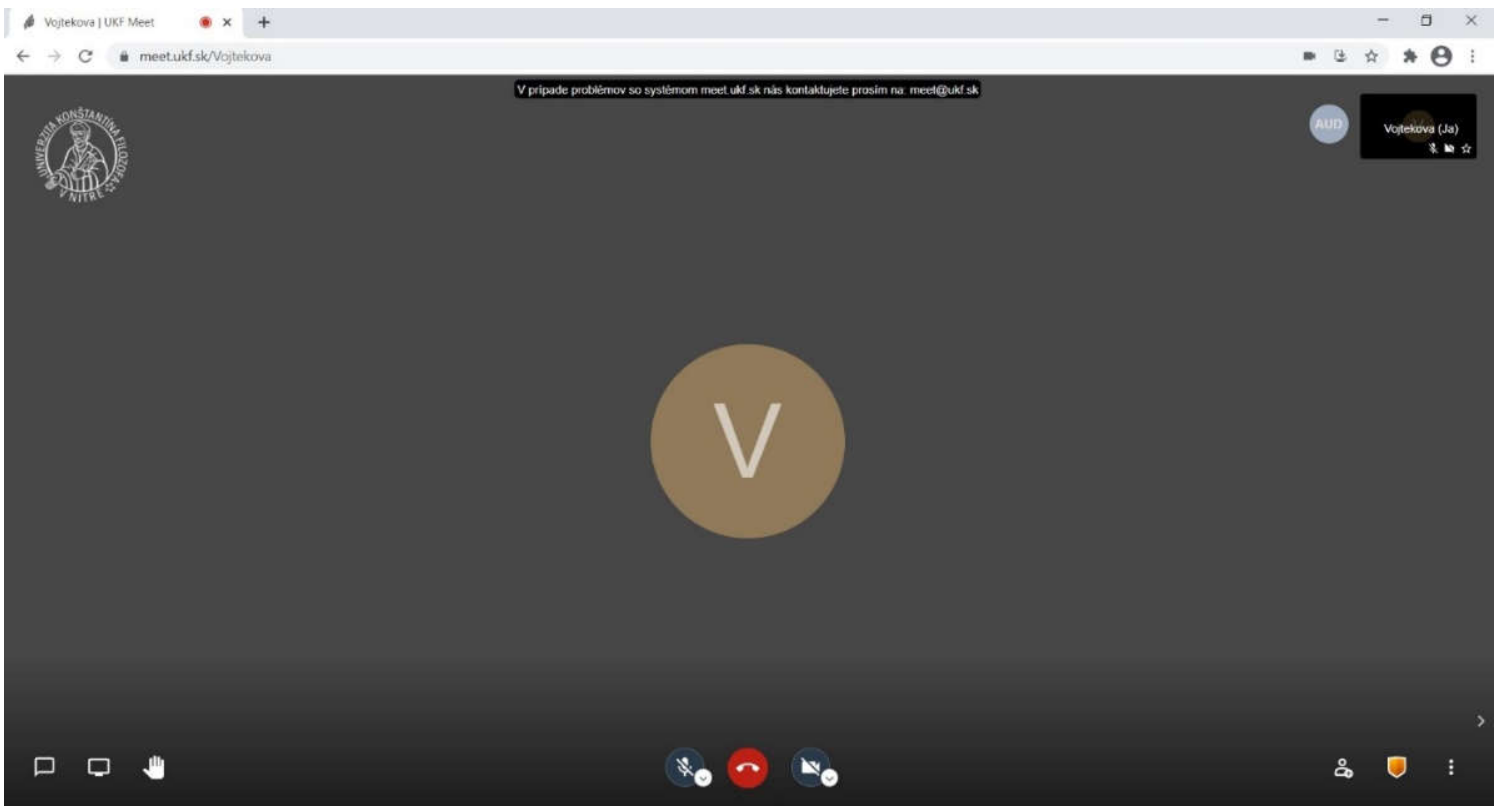
Jitsi is a group of open-source projects that make it easy to create and implement secure video conferencing solutions (
Figure 1). The heart of Jitsi are Video bridge Jitsi and JitsiMeet meetings allow organizing conferences on the Internet, while other projects in the community allow additional features such as sound, dial-in, recording, and simulcasting. JitsiVideobridge transmits video and audio to all participants before mixing it. It represents better quality, lower latency and if it is run on own services, it provides much more scalable and cheaper solution. Jitsi is compatible with WebRTC, an open standard for web communication. It provides advanced video routing support for simulcast, bandwidth estimates, scalable video encoding, and many more as well as Ubuntu and Debian packages for easy installation. JitsiMeet was launched in 2003 (
https://jitsi.org/about/ accessed on 30 March 2021).
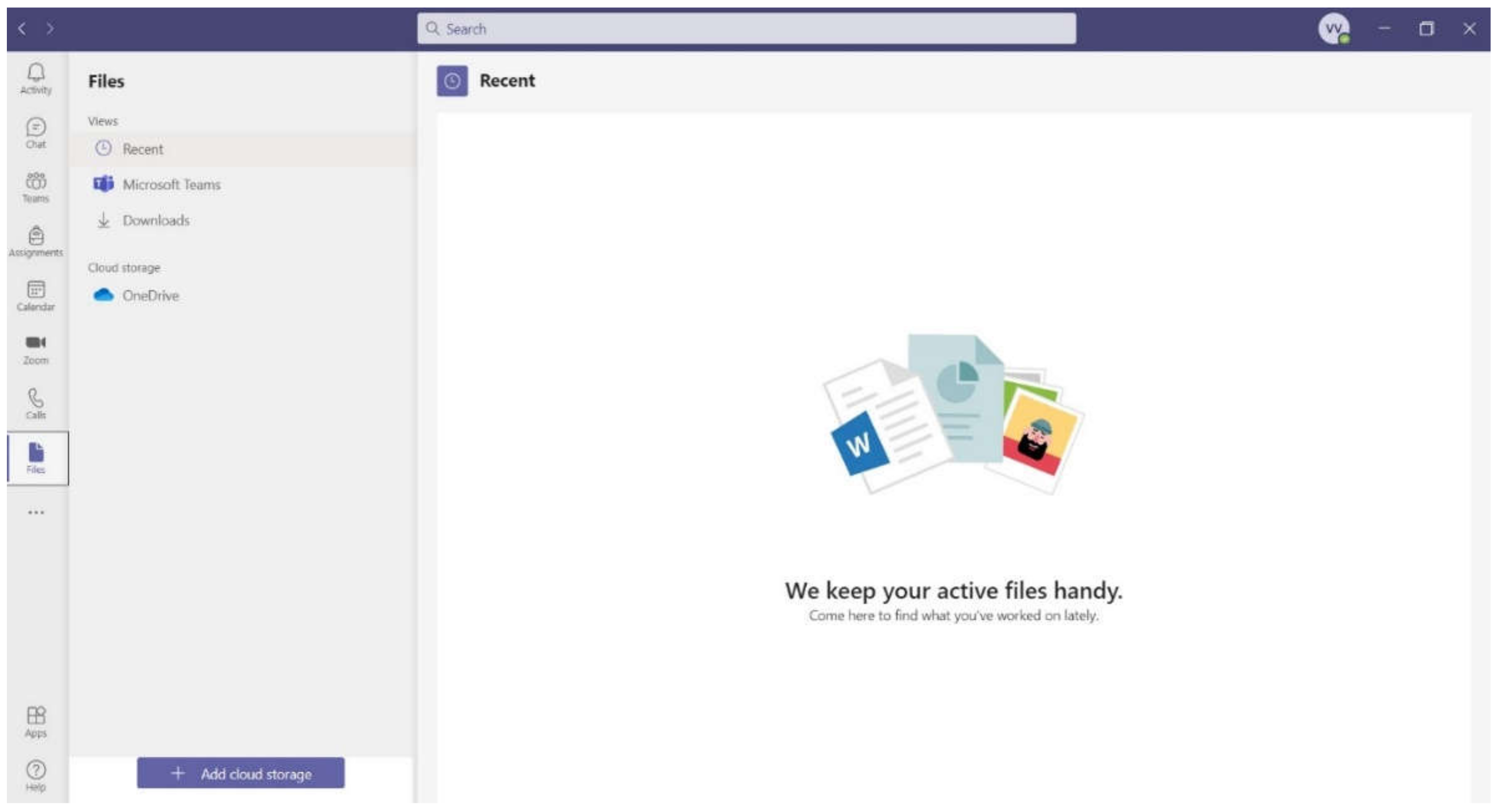
Similar applications to JitsiMeet are, for example, MS Teams, Zoom, Skype, Google Meet, or Cisco Webex. MS Teams and JitsiMeet applications are mostly used at Slovak universities. MS Teams is part of the Microsoft 365 Education service. Students and teachers at eligible institutions can register for Office 365 Education free of charge. It is a workspace for real-time collaboration and communication, meetings, file and application sharing, and more. It includes chat with sharing the text, audio, video, and files and allows private chat, which can later be shared with the entire organization. It also offers the ability to store files, documents, and other things in one place. MS Teams consists of channels, which are conversations that can take place, e.g., with teammates. Each channel is dedicated to a specific topic or project. Other applications can also be loaded, such as PowerPoint. Among other things, there is also a calendar with the possibility of planning as well as reminding of individual tasks or events (
Figure 2). Microsoft launched the Teams application in 2016. MS Teams is the successor to the Skype for Business platform, which will end on 31 July 2021 [
33].
The JitsiMeet and MS Teams applications have many things in common, such as they enable video conference calling with a larger number of participants, enable private and public chat, allow screen or file sharing, recordings of calls, and the like. However, MS Teams enables also to share and store files, which is not the case of JitsiMeet. In addition, JitsiMeet does not contain a planning calendar and one cannot enter tasks. The reason for choosing the JitsiMeet application was that the whole university, where the research was conducted, commonly uses this application for online teaching.
After the first month of distance learning, students completed an anonymous questionnaire where they were asked to express their opinion on GIS learning using video tutorials and textbooks, as well as to indicate whether they had devices that enable online learning (PC, audio and video outputs, Internet), as well as to express their opinion and experience with online learning as such.
The online questionnaire was created using Google forms and was then sent to students on their email. Students had one week to complete and submit an anonymous questionnaire. The questionnaire contained one open-ended question and eight multiple-choice questions (
Table 1).
After completing the distance learning of GIS, a questionnaire was again sent to students with questions about satisfaction with the given instructions. The questionnaire was also anonymous and created using Google forms. It was also sent to the students’ emails and they had one week to complete and submit an anonymous questionnaire. The questionnaire contained one open-ended question and three multiple-choice questions (
Table 2).
Before the start of the research, research hypotheses were established based on the teacher’s experience with teaching GIS and also on the basis of the problems the teacher encountered during teaching and which the students had to solve:
Hypothesis 1 (H1). Video tutorials and textbooks are not enough for students to learn a new curriculum from GIS.
Hypothesis 2 (H2). Students prefer an online conference system to self-education using video tutorials and textbooks to learn GIS.
Hypothesis 3 (H3). Students have adequate technical equipment available at home to use GIS for self-education.
We conducted a pedagogical experiment to verify the validity of the work Hypotheses H1–H3. We verified the validity of the work Hypotheses H1 to H3 on the basis of an analysis of the answers to the questions included in the questionnaire. The results obtained by the questionnaire method were analyzed using selected statistical methods. As the analysis goal was to establish the links between the different questions on the basis of the students’ answers, we found the dependence of two qualitative characteristics A, B. These two characters (A, B) represent several pairs of questions, for which we verified their statistical dependence using statistical methods, for example, statistical dependence between questions Q1 and Q6, and the like. The H0 hypothesis is the independence of observed signs A, B. We tested H0 hypothesis against an alternative hypothesis H1 that indicates that the observed signs A and B are dependent. Since the signs A, B are alternative signs, we used
-test for association table [
34] to test H0. The test criterion is statistics using Equation (1).
where
are empiric and
are expected (theoretical) numbers. Statistics
has (if test hypothesis H0 is valid)
-division with one degree of freedom asymptotically. Test hypothesis
on the independence of observed signs A, B are rejected at the level of significance
, if the test criterion value
exceeds the critical tabular value
-division. The STATISTICA software was used to perform the test.
Note. If any expected number is less than 5 in a sample with range
n, where 20 <
n 40, Fisher’s test can be used instead of
-test to test the independence of the two alternative signs. In this case, we reject the tested hypothesis H0 in favor of a one-sided alternative hypothesis at the level of significance
, if the value of the test criterion
p < α. In the case of Fisher’s test, we assume that we observe two dichotomous signs A, B on
n elements of the sample. Let the levels of observed signs A, B be arranged in the association Table 2 × 2. In this case, too, let us test the null hypothesis H0 “signs A, B are independent” compared to the alternative hypothesis H1 “there is a statistically significant dependence between the signs A, B”. The
p-value for the Fisher’s test is given by Equation (2).
We reject the null hypothesis H0 about the independence of the monitored signs A, B at the level of significance if the calculated p-value is less than the selected level of significance
In case statistically significant dependence was demonstrated between the observed signs, we also calculated the degree of this dependency using a contingent coefficient.
The contingent coefficient is defined by Equation (3).
The contingent factor C acquires values from the interval . If signs A, B are independent. Values close to zero indicate weak dependency and, conversely, values close to 1 strong dependency. The interpretation of other contingent coefficient values is the same as the interpretation of correlation coefficient values.
3. Results
The research was focused on the perception of GIS distance learning, as well as on the technical equipment of students, which was necessary for the learning. As mentioned above, the first month we sent students GIS textbooks and video tutorials. We were interested in whether students could learn the subject from GIS also with the help of video tutorials and textbooks. We found that up to 71% of students were comfortable with self-education using video tutorials, but only 57% used GIS textbooks for self-education. Twenty-nine percent of students did not use video tutorials or textbooks for self-education, which indicates that this form of learning did not suit all students, or they were not used to this form of learning and, thus, they ignored it. Before starting distance learning using the JitsiMeet application, we also asked students about their technical support, which was necessary for learning GIS. Before starting learning, only 43% of students installed ArcGIS 10.x software, which was provided free of charge by Esri, 93% of students had audio outputs, and 71% owned a microphone. When teaching through the JitsiMeet application, it was not necessary for students to have ArcGIS software installed at the time, as they watched the teacher’s shared screen and took notes. However, to complete their homework, they already had to have the software installed; we alerted the students after the questionnaire, and after the notification, everyone installed the software. Ninety-three percent of students owned the audio outputs (speakers) that were needed to teach GIS through the JitsiMeet application and 7%, i.e., two students did not have such a device. After an agreement with these students, they borrowed speakers, or purchased it. Twenty-nine percent of students did not have a microphone and we solved this problem using chat. When they wanted to ask something during the lesson, they wrote the question to the teacher in the chat, or all communication took place via chat.
When the students were asked whether a conference call would be suitable for them, up to 82% of students answered that they would like this form of learning, even though so far only 36% of students had experience with this form of learning in other subjects. During distance learning using a conference call on other subjects, students most often introduced the Skype application (five students), then JitsiMeet (three students), and finally the zoom.us application (two students). Thirty-six percent of students already knew the JitsiMeet application. After completing the distance learning, the students were given homework, and they had to make a map according to the instructions given by the teacher. Students would not be able to complete the assignment if they did not have the knowledge they had to learn during distance learning. All students handed in the homework, but 82% of students had the map flawless and 18% of students had to correct the map. After the repair, all the maps were all right.
Moreover, after completing the distance learning using the JitsiMeet application, video tutorials and sent GIS textbooks, we again sent a questionnaire to the students to find out the students’ opinion on the distance learning during the COVID-19 pandemic. We found that up to 89% of students were comfortable learning through the JitsiMeet application, with up to 82% of students saying that they learned more from GIS during distance learning than during face-to-face instruction and up to 71% of students preferred distance learning over face-to-face instruction.
We also evaluated the questionnaire responses using the statistical methods we described in the work methodology. In verifying the validity of the research hypotheses H1 to H3, we verified the statistical significance of the link between the answers to the following selected questions included in the questionnaire.
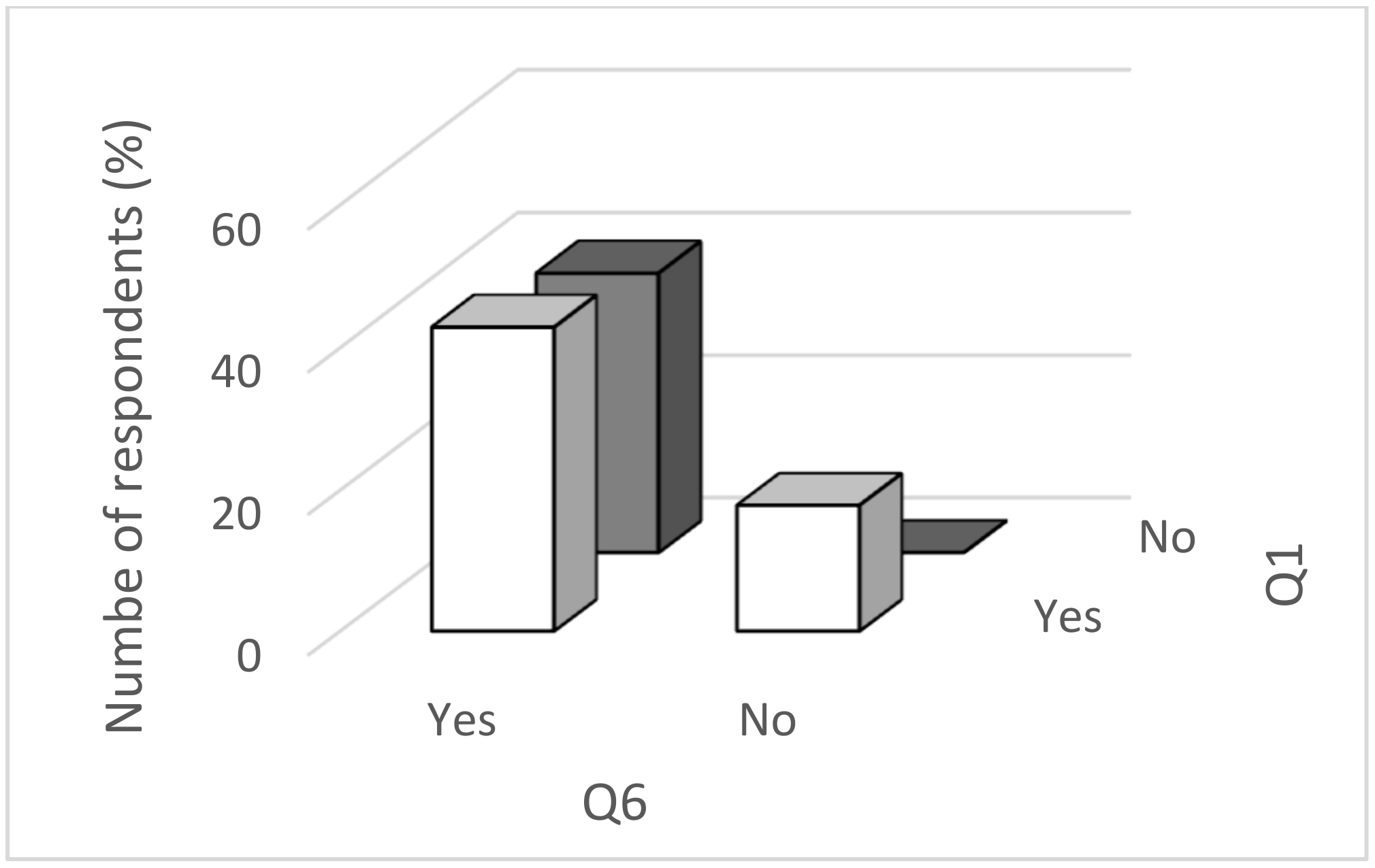
In verifying the hypothesis that there is a statistically significant link between acquiring new knowledge from the GIS using video tutorials (Q1 question) and agreeing to teach GIS via an online application that can be used, e.g., conference call (Q6 question), we used
-independence test for the association table. We carried out the
-test in STATISTICA software. After entering the input data, we received the following association table (
Table 3) in the computer output report, the
-test criterion value, and the probability
p-value, which is the probability of an error that we commit when we reject the test hypothesis. If the calculated
p-value is small enough (
p < 0.05 and
p < 0.01), the test hypothesis on the equality of the mean levels of observed signs is rejected (at significance levels of 0.05 and 0.01). Otherwise, the hypothesis cannot be rejected, the observed differences are not statistically significant.
As the probability
p-value is less (
p = 0.047) than the selected level of significance, the hypothesis H0 is rejected on the level of significance and alternative hypothesis H1 is accepted. This means that the acquisition of new GIS knowledge using video tutorials has a statistically significant impact on the consent to GIS learning via an online application through which, for example, a conference call can be used. We also illustrated the situation in
Figure 3 and
Figure 4.
Based on the graphic representation, we can see that students’ answers to both questions have the following division of numbers: 43% of students acquired new knowledge from GIS using video guides and at the same time, they agreede to learn GIS via an online application, 39% did not acquire that knowledge using video tutorials and at the same time, they agreed to learn via an online application, 18% of students did not agree to learning online, but they acquired the knowledge using video manuals, and zero students (0%) did not acquire the knowledge without the use of video tutorials and at the same time did not agree to online learning.
Figure 4 also shows that up to 61% of students answered the question whether they had acquired new GIS knowledge using video tutorials in the affirmative, and up to 82% of students agreed to online learning.
Statistical significance of the relationship between the acquisition of new GIS knowledge using video tutorials (question Q1) and consent to GIS learning through an online application, through which it is possible to use, e.g., the conference call (question Q6) we verified using Fisher’s test. We calculated p = 0.049. Since the calculated p-value is less than 0.05, we reject the hypothesis H0 on the independence of the observed signs at the level of significance = 0.05. Using Fisher’s test, we got the same result as using -test.
Next, we calculated the contingency coefficient value between the acquisition of new GIS knowledge using video tutorials and consent to GIS learning through the online application C = 0.697. There is a significant degree of connection between the acquisition of the above GIS knowledge and the consent to its learning online.
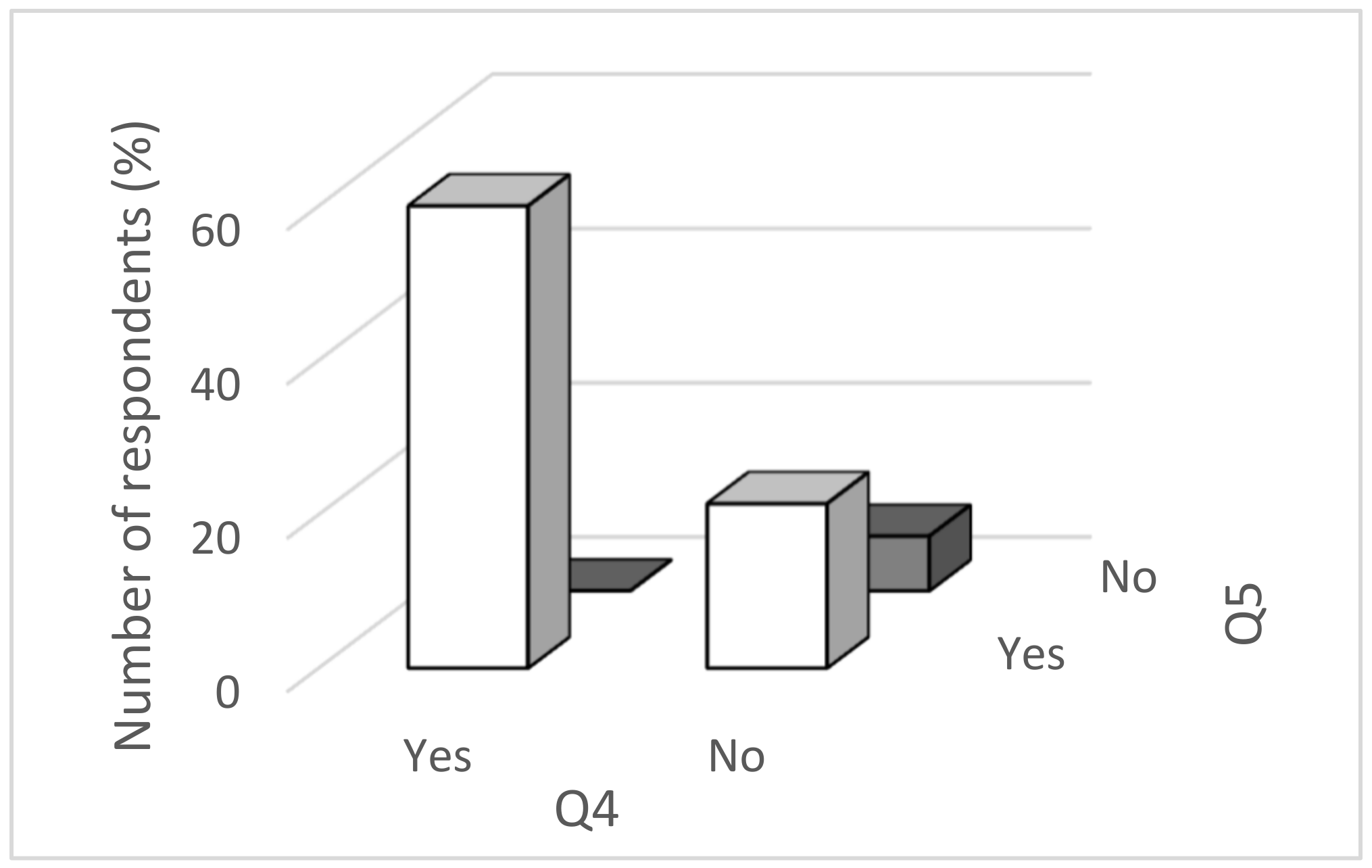
In the following, we investigated whether there is a connection between:
Owning the audio output (speakers) on PC or laptop (question Q4) and owning a microphone on PC or laptop (question Q5), and
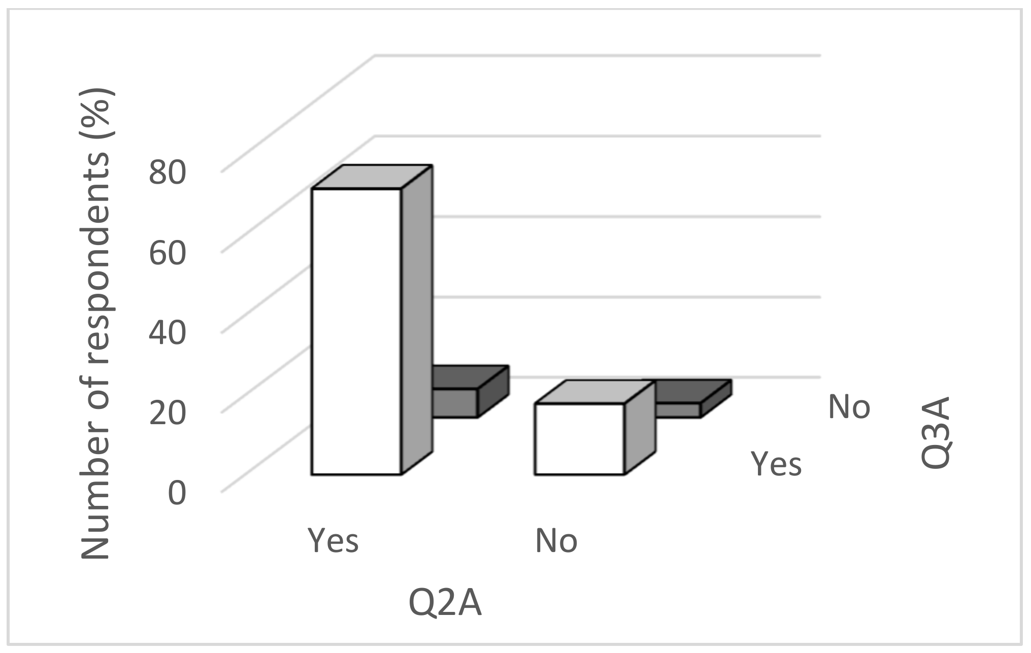
Preferring GIS learning using video tutorials, textbooks, and the JitsyMeet application over the face-to-face instruction of GIS learning (question Q2A) by preferring the distance form of GIS learning over the face-to-face instruction (question Q3A).
In verifying the above connections, we proceeded analogously as in the previous section. In both cases, we calculated the value of the test criterion, the probability
p-value, and the probability value of the Fisher’s test. The results are clearly written in
Table 4.
From
Table 4, it can be seen that there is a statistically significant dependence in both investigated cases between the ownership of the audio output (speakers) on PC or laptop (question Q4) and owning a microphone on PC or laptop (question Q5) and between the preference for GIS learning using video tutorials, textbooks, and the JitsiMeet application over the face-to-face instruction of GIS learning (question Q2A) and the preference for the distance form of GIS learning over the face-to-face instruction (question Q3A).
The test proved that the ownership of audio output (speakers) on PC or laptop is statistically significantly related to the ownership of a microphone on PC or laptop and the test showed that the preference for GIS learning using video tutorials, textbooks, and the JitsiMeet application over the face-to-face instruction of GIS learning is statistically significantly related to the preference for the distance form of GIS learning over the face-to-face instruction. We also illustrated the situation in
Figure 5 and
Figure 6.
In both cases, we also calculated the tightness of the bond between the observed signs.
Contingency coefficient between the ownership of audio output (speakers) on PC or laptop (question Q4) and owning a microphone on PC or laptop (question Q5) is C = 0.931, i.e., between owning the audio output and owning a microphone on PC or laptop is very tightly bound.
Contingency coefficient between the preference of GIS learning using video tutorials, textbooks, and the JitsiMeet application over the face-to-face instruction of GIS learning (question Q2A) and the preference of the distance form of GIS learning over the face-to-face instruction (question Q3A) is C = 0.995, i.e., between the preference for learning GIS using video tutorials, etc. and the preference for the distance form of GIS learning over the face-to-face instruction is a very close bond.
Based on the analysis of the results obtained by the questionnaire method, the use of statistical methods confirmed that the acquisition of new knowledge from GIS using video tutorials has a statistically significant effect on consent to GIS learning of through an online application conference call. This confirmed the validity of the research hypothesis H1, i.e., video tutorials and textbooks are not enough for students to teach new GIS curricula.
Using statistical methods, it was also shown that the preference for GIS learning using video tutorials, textbooks, and the JitsiMeet application over the face-to-face instruction of GIS learning is statistically significantly related to the preference for the distance form of GIS learning over the face-to-face instruction. This confirmed the validity of the research hypothesis H2, i.e., students prefer learning GIS through an online conferencing system to self-education using video tutorials and textbooks.
Finally, the use of statistical methods showed that owning the audio output (speakers) on PC or laptop is statistically significantly related to the ownership of a microphone on PC or notebook. This confirms the validity of research hypothesis H3: Students have at their disposal adequate technical equipment for self-education in GIS.
We also verified the statistical significance of the relationship between other questions from the questionnaire. In all these cases, we also calculated the value of the test criterion, the value of the probability p and the probability of occurrence of the Fisher’s test. The results are clearly written in
Table 5.
From
Table 5, we can see that in all cases
p-value is greater than 0.05, i.e., statistically significant links between the answers were not shown in either case.
4. Discussion
Besides the advantages of the presented teaching method, there are also some disadvantages, which are discussed in this section. Moreover, in online learning, we encountered with several advantages and disadvantages, which were also described in other similar works [
35,
36,
37,
38].
In our research, we encountered with several problems that we had to solve. One of the problems was that many teachers had to learn to work with new technologies, to adapt the content of learning, but also to choose adequate technologies for distance learning, which in many cases was a problem. According to several studies [
2,
39,
40], the lack of previous experience of teachers with new technologies in their teaching can reduce the effectiveness of the application of new technologies in teaching. In our case, the biggest problem was choosing a suitable free conference call application. At first, we chose the zoom.us application, which provided an one-hour free conference call per day, but when learning GIS through this application, when the computer screen was shared with ArcGIS 10.2 software turned on, students stopped hearing the teacher and the teacher did not hear students. Even after turning off screen sharing, the sound between students and the teacher was not restored. However, the students still heard each other. After these complications, we switched to the free JitsiMeet application, which was programmed for our university (Constantine the Philosopher University in Nitra). There were no complications when using this application during distance learning GIS. Screen sharing, communication with students, and chat worked without problems.
Another problem that occurred during our research was that not all students had adequate technologies that would allow learning GIS in the distance form. We solved this problem as mentioned above. This problem is only minimal at universities, but at primary and secondary schools in Slovakia this problem is much more visible. It is mainly in equipping households with adequate technology, but also in the digital skills of students. For example, the development of EU Member States in digital competitiveness is followed by the comprehensive Index of the Digital Economy and Society (DESI), which summarizes the relevant indicators of Europe’s digital performance. According to DESI, in 2019, Slovakia was in 21st place among the 28 EU member states. In order to change this situation, education must be first to begin with, whether at primary or secondary schools, but above all it is the education of future teachers in the university environment. If a teacher does not have digital skills, he/she cannot even teach students to use them in the educational process [
41].
Another problem that appears in the future distance learning of GIS is the acquisition of ArcGIS 10x software, in which the subject is taught. The GIS e-learning project Geographic Information Technology Training Alliance (GITTA), which was implemented at seven universities in Switzerland [
42], also had to solve this task.
In our research, students were able to use a free license of this software until the end of August 2020, which was provided by the company Esri during the COVID-19 pandemic. As the COVID-19 pandemic have continued, we also had to address GIS training in the summer semester 2021. Fortunately, the Esri company has extended free licenses of ArcGIS 10.x until June 2021. Therefore, GIS training continues via a distance mode using the JitsiMeet application, which proved to be suitable for teaching in previous winter semester 2020.
If a situation arises that distance learning will have to continue from September 2020 and Esri would no longer provide a free license of this software, there will be a major problem that will have to be addressed either by switching to free GIS software, such as QGIS or Grass GIS, or an agreement would have to be reached between the university and Esri, accessible to students. Argles [
35] also solved problems with finding suitable software for online GIS learning.
Applying science to solve society’s problems in the 21st century requires a science-literate society—and to achieve this goal, a link between learning and science is essential [
43].
From the results of the research, we can see that the vast majority of students (89%) were satisfied with the distance learning of GIS, which indicates that, as inquiry-based science education has already been introduced in many schools in developed countries, it would be appropriate to introduce such learning principle at universities. Inquiry-based science education (IBSE) is an approach to learning, a strategy for managing a student’s learning activities that can be applied in both the natural and human sciences. It is, thus, a purposeful process of formulating problems, critical experimentation, assessing alternatives, planned research and verification, drawing conclusions, searching for information, creating models of studied events, discussing with others, and forming coherent arguments [
44]. For university students, this will strengthen the link between research and learning and gain a better understanding of the field they are studying [
45]. At the same time, they are more motivated to engage in research activities in the field of study [
46]. In research-oriented learning, the teacher represents only a mentor, or learning guide. In this education, the student works at his/her own pace, searches for information, and learns on the basis of his/her own acquired experience, knowledge, and skills. This form of learning shows very good study results. It was proved also in other works [
47,
48,
49,
50].
The COVID-19 pandemic and sudden adaptation of learning in our research also confirms that inquiry-based science education focused on self-education of students, where the teacher acts as a mentor or study guide is proving to be very appropriate and promising. In integrating IBSE into education, it is also necessary to replace the traditional role of the student as a “passive observer” who gathers information with the role of an “active designer” [
51]. According to Crawford [
52], students’ active cooperation with the teacher is very important at IBSE. The difference between inquiry-based science education and distance learning is in the environment where the learning takes place. Inquiry-based science education takes place at school and the distance form of education takes place in the home environment.
The results of our research indicate that students perceive a distance form of GIS learning positive if they have adequate educational materials and resources. Yoon [
53] describes similar results in his research, where he describes the benefits of online learning and its preference for university students. Sharifi and Aslitdinova [
54], also describe distance learning in its research and its benefits and implementation in Tajikistan. Therefore, it is important for the teacher to be able to prepare adequately and adapt to this form of learning not only during the COVID-19 pandemic, but also outside it. According to Eslaminejad et al. [
55], the basis of modern learning is a teacher who has sufficient knowledge of working with electronic media.
5. Conclusions
The presented research showed students’ satisfaction with the JitsiMeet application, regardless of whether students worked with this application for the first time or not. This finding is especially important when neither the teacher nor the students have the time or space to learn to work with new applications designed to teach using a video conference call, but need to get on the distance learning method immediately. The JitsiMeet application proved to be reliable and easy-to-use, whether it was screen sharing or communication via chat, and the like. Overall, up to 89% of students were satisfied with distance learning using the JitsiMeet application. As advantages of distance education, students mentioned, for example, their own pace in learning, flexibility of learning time, and less disruptive elements in teaching. By applying a videoconferencing call, we managed to eliminate the implementation of teaching GIS with the so-called “buttonology” method, where students only follow the work with GIS according to the instructions with cookbook-style activities. As disruptive elements, students mentioned, for example, slower pace of some students to whom the full-time teaching had to adapt or noise in the GIS laboratory when students communicate with each other, and the like.
In Slovakia, in June 2020 and during the COVID-19 pandemic, kindergartens and the first stage of primary schools were opened, in July and August 2020, pupils had holidays and the new school year began again in September. Since 1 September 2020, most kindergartens and primary and secondary schools have opened and continue with face-to-face instruction, but some schools have remained closed (due to the occurrence of COVID-19 among teachers or pupils) and learning continues in the distance form. In November 2020, all types of schools again switched to distance learning, which lasted until February 2021. In February, the kindergartens and the 1st level of primary school were opened while the 2nd level of primary schools, secondary schools, and higher education continues at distance education. School-leaving exams at secondary schools were canceled and state examinations at universities will take place online. It is questionable how the COVID-19 pandemic will evolve, whether again all students will have to be educated in a distance form, and if so, teachers must, after previous experience, prepare for quality learning using new and available technologies. This situation has also led universities to create many courses for teachers, which are focused on learning through Moodle e-learning and conference calls.


