Toward an Integrated and Sustainable Water Resources Management in Structurally-Controlled Watersheds in Desert Environments Using Geophysical and Remote Sensing Methods
Abstract
1. Introduction
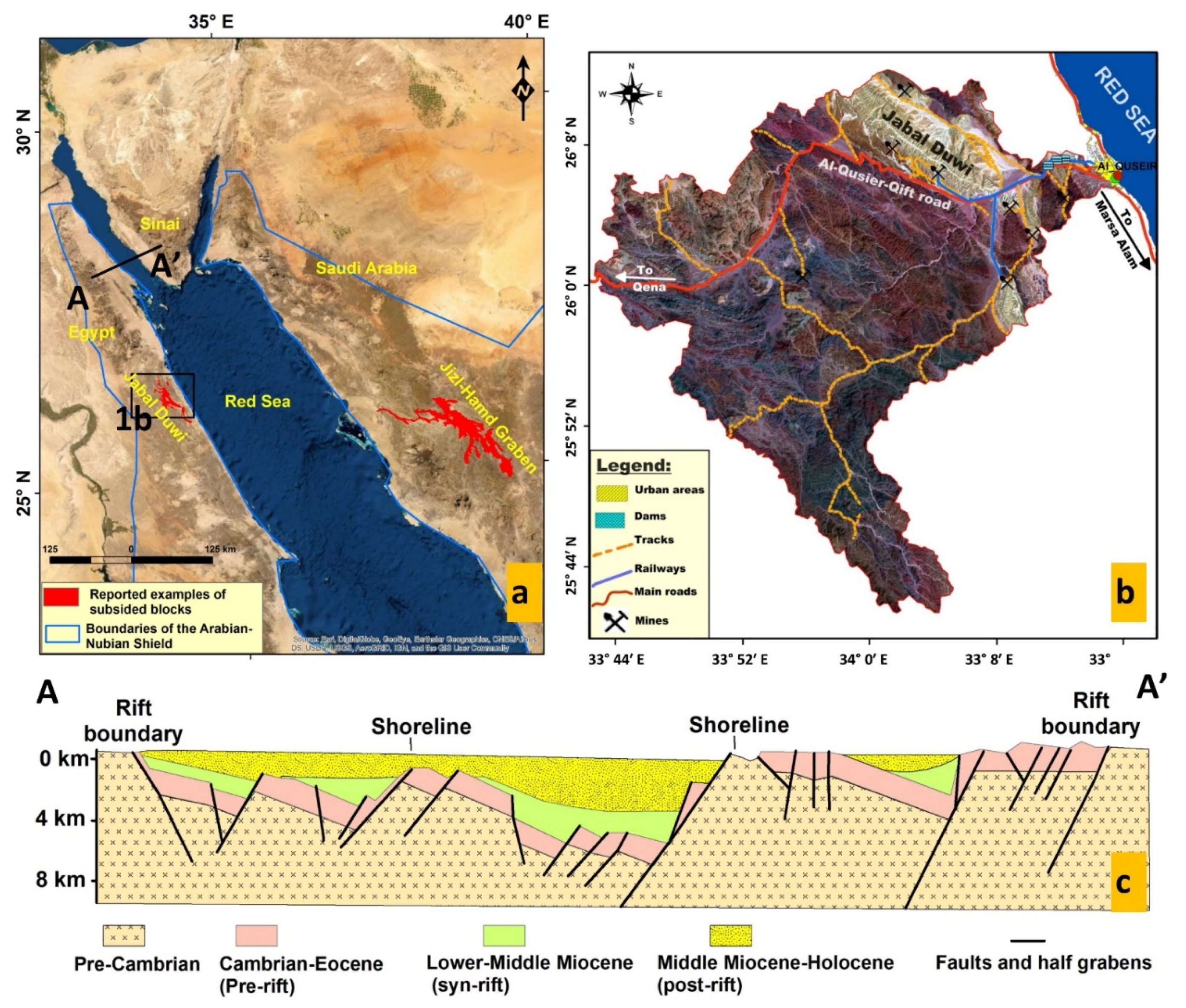
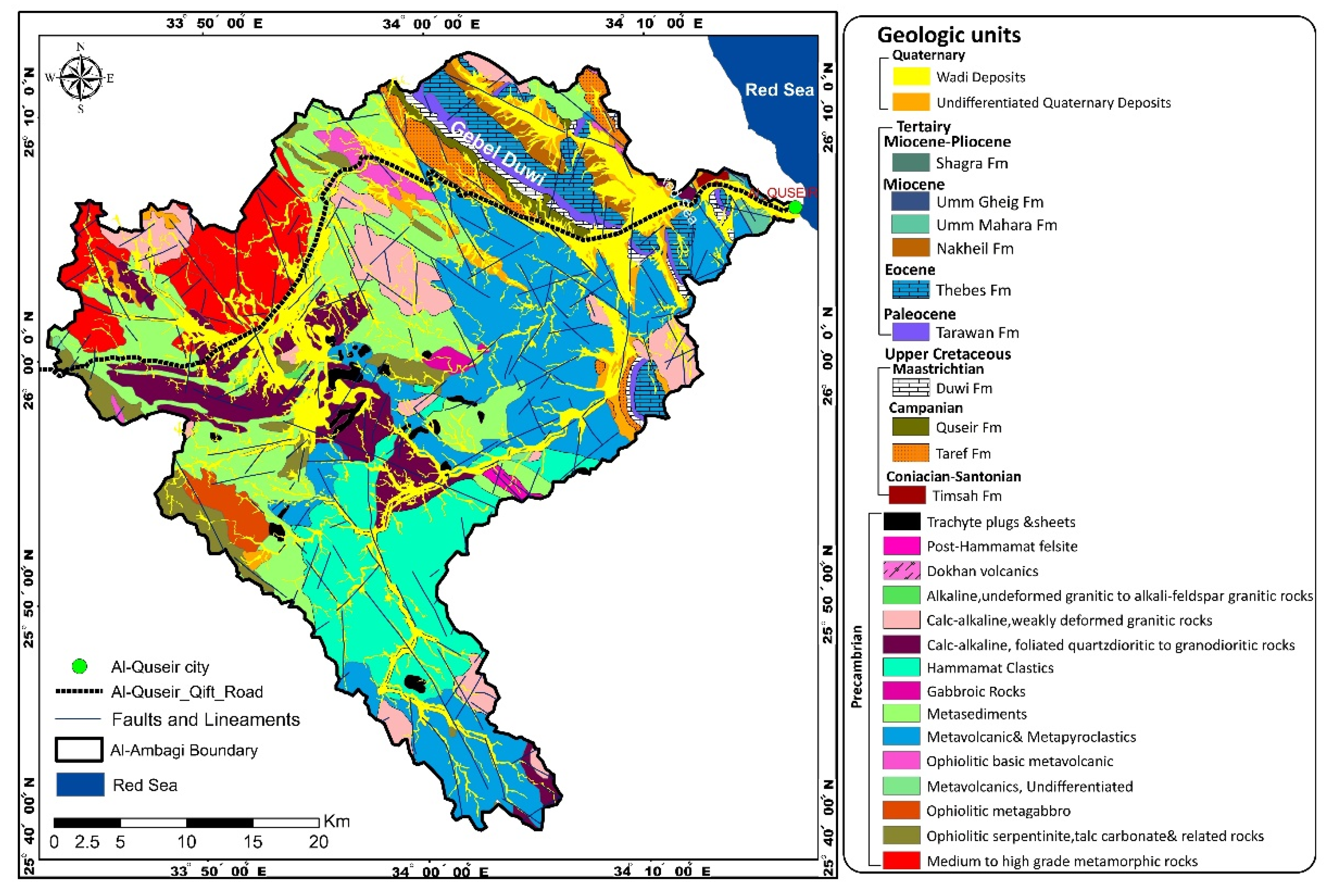
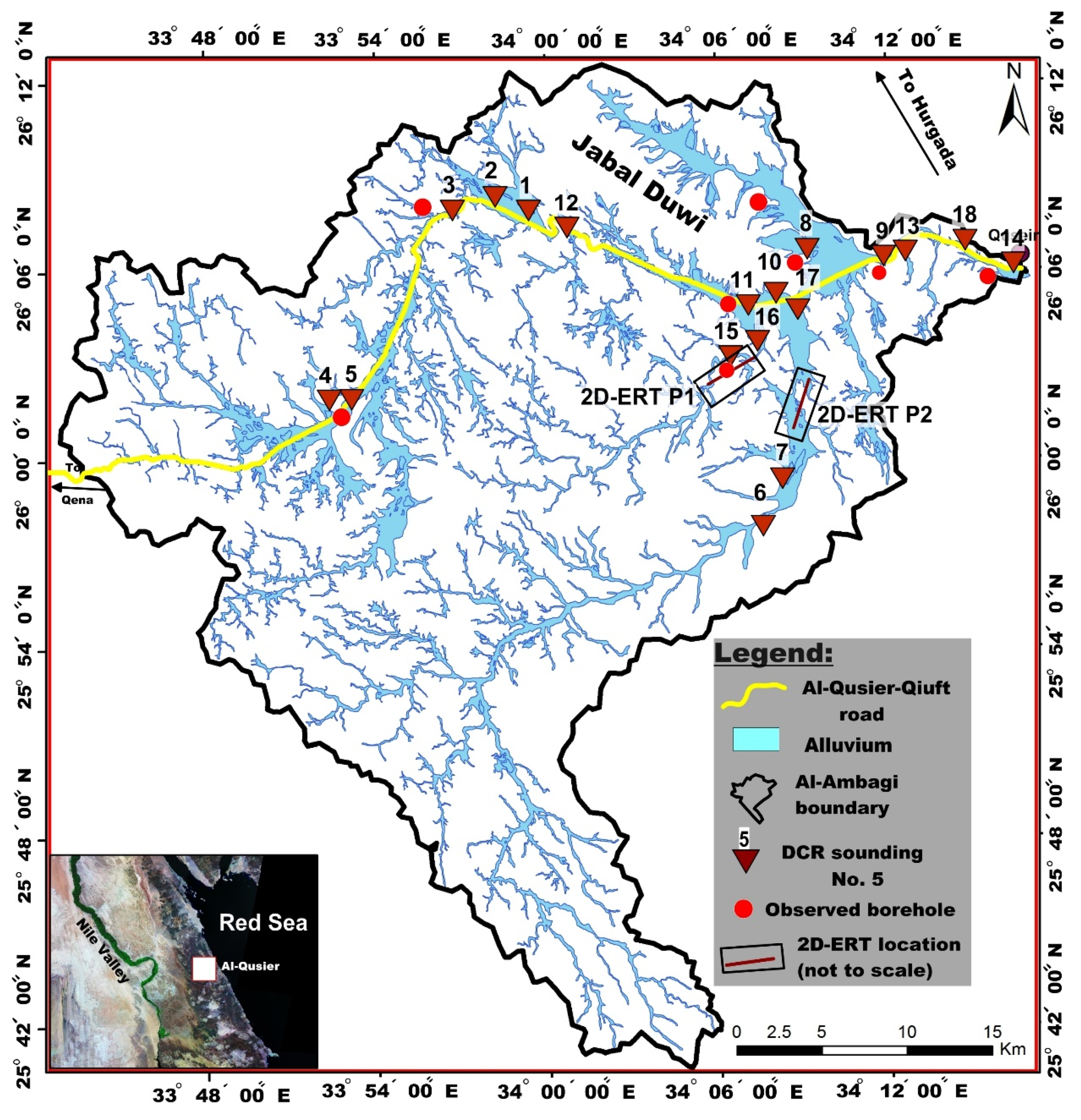
2. Site Description
3. Materials and Methods
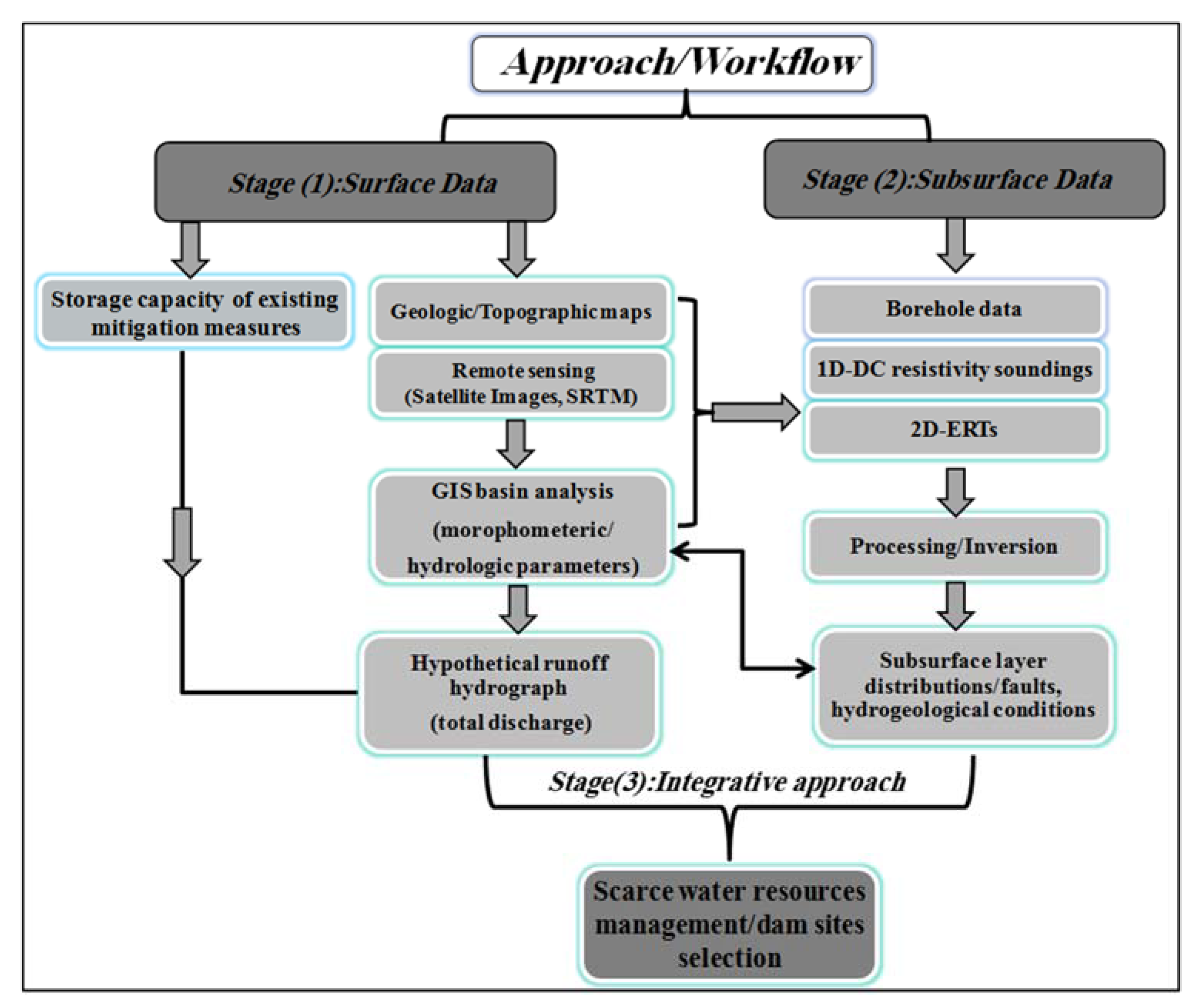
3.1. Approach Overview
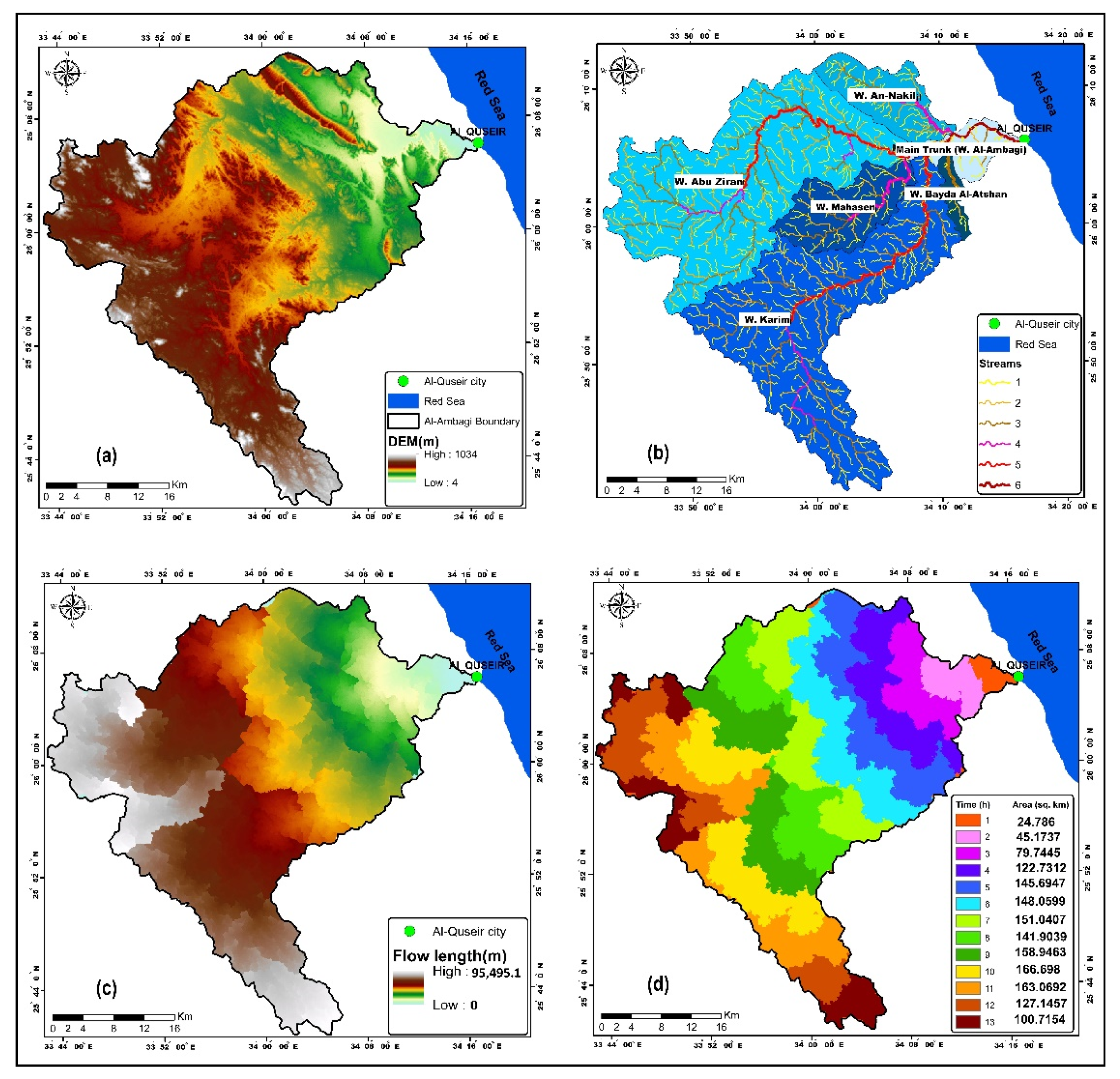
3.2. Extraction of Surface Hydrological Parameters (Stage I)
3.3. Subsurface Data Acquisition/DCR Inversion (Stage II)
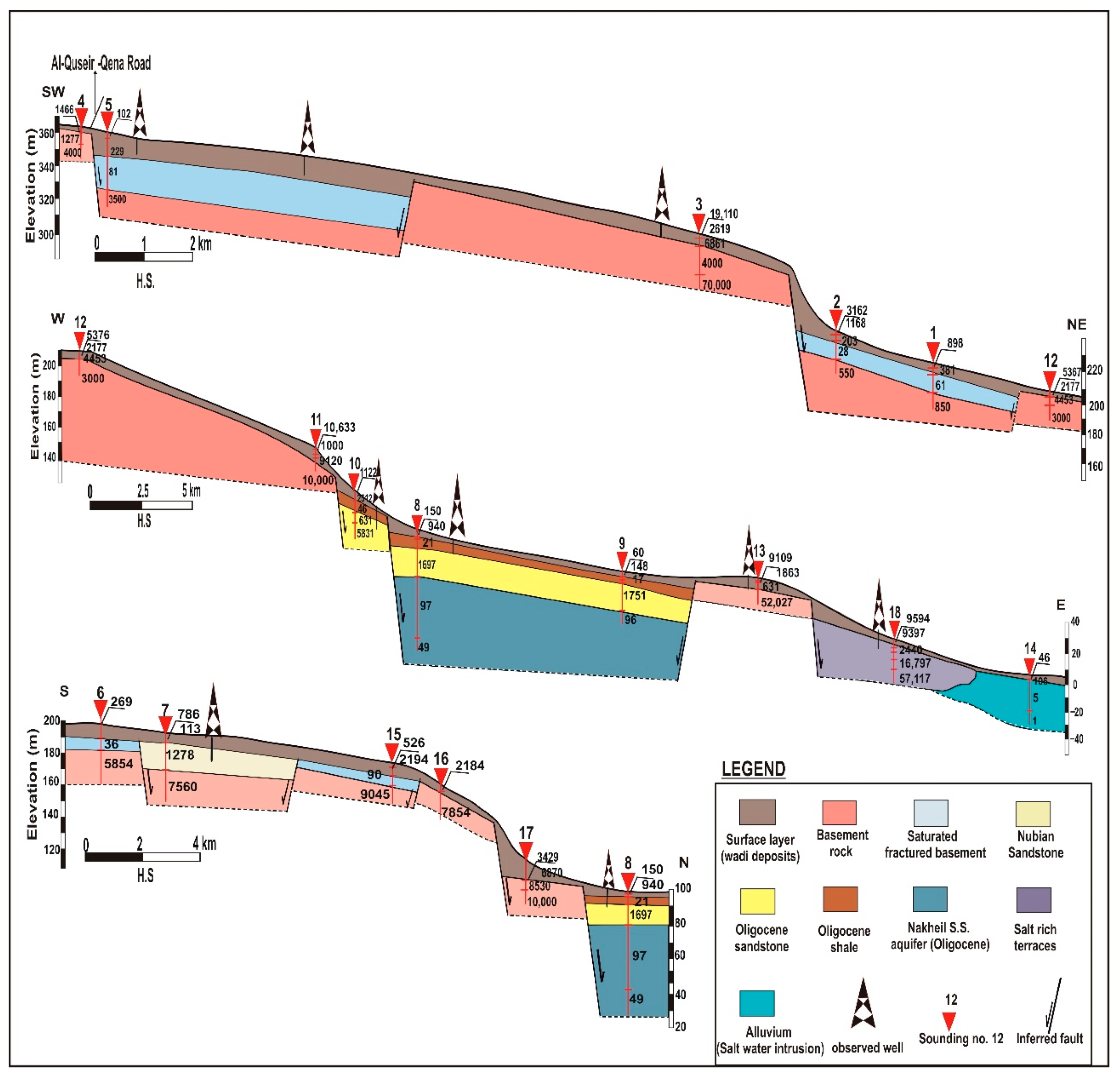
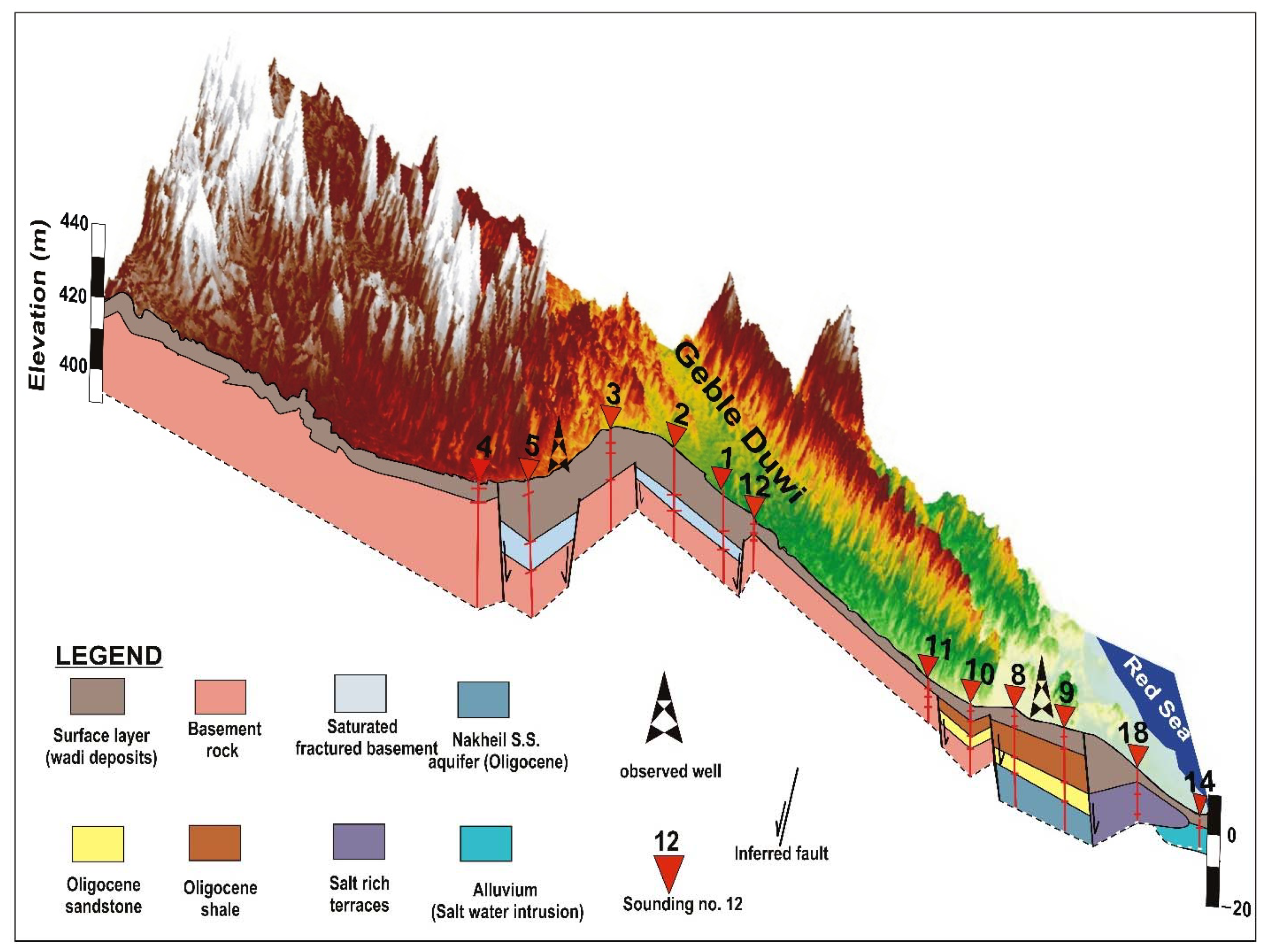
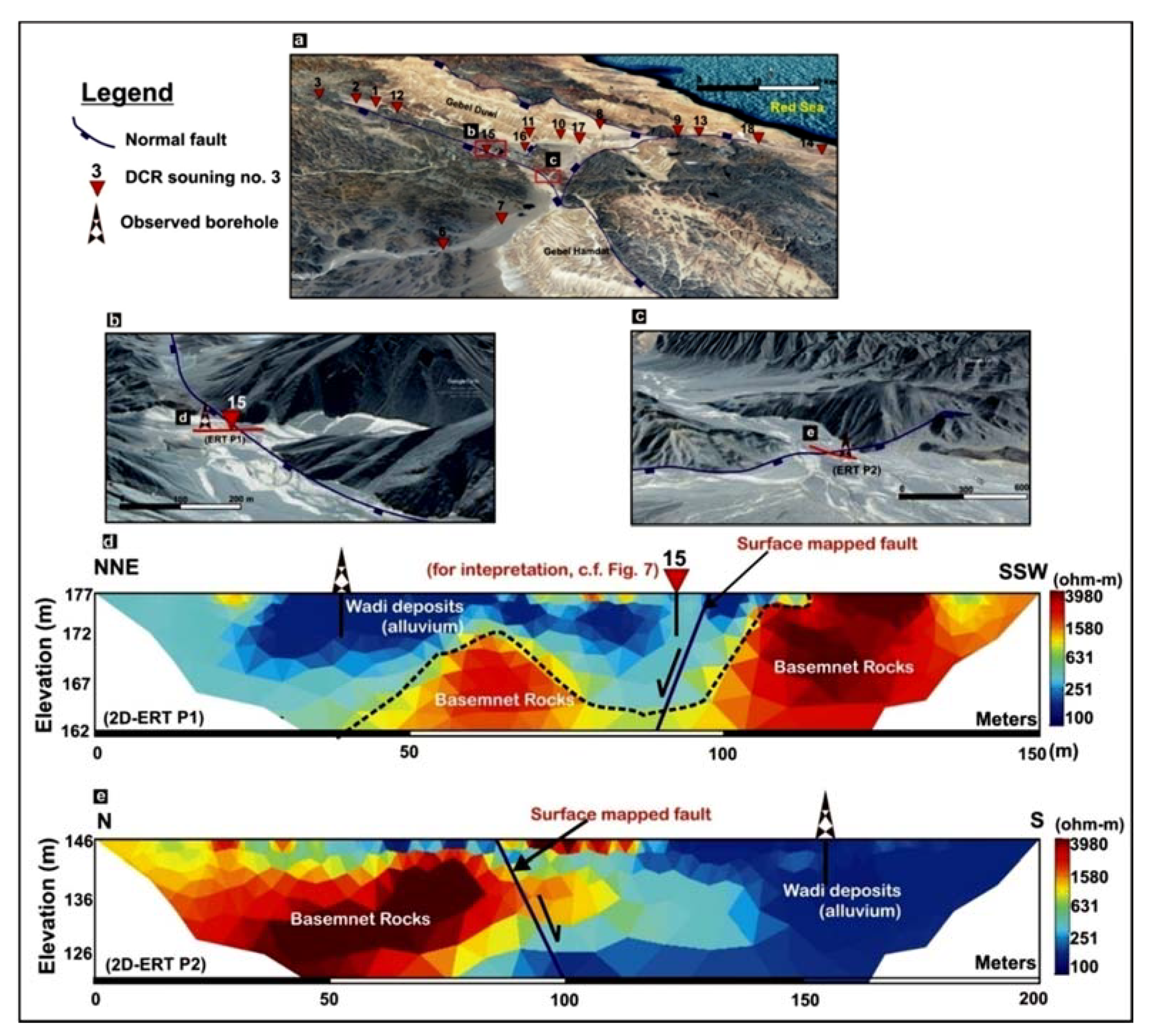
4. Results and Discussions
5. Conclusions
Author Contributions
Funding
Data Availability Statement
Acknowledgments
Conflicts of Interest
References
- Ligi, M.; Bonatti, E.; Bosworth, W.; Cai, Y.; Cipriani, A.; Palmiotto, C.; Ronca, S.; Seyler, M. Birth of an ocean in the red sea: Oceanic-type basaltic melt intrusions precede continental rupture. Gondwana Res. 2018, 54, 150–160. [Google Scholar] [CrossRef]
- Sultan, M.; Yousef, A.F.; Metwally, S.E.; Becker, R.; Milewski, A.; Sauck, W.; Sturchio, N.C.; Mohamed, A.; Wagdy, A.; El Alfy, Z. Red sea rifting controls on aquifer distribution: Constraints from geochemical, geophysical, and remote sensing data. GSA Bull. 2011, 123, 911–924. [Google Scholar] [CrossRef]
- Ahmed, M.; Sauck, W.; Sultan, M.; Yan, E.; Soliman, F.; Rashed, M. Geophysical constraints on the hydrogeologic and structural settings of the Gulf of Suez rift-related basins: Case study from the El Qaa plain, Sinai, Egypt. Surv. Geophys. 2014, 35, 415–430. [Google Scholar] [CrossRef]
- Yousif, M.; Hussien, H.M.; Abotalib, A.Z. The respective roles of modern and paleo recharge to alluvium aquifers in continental rift basins: A case study from El Qaa plain, Sinai, Egypt. Sci. Total Environ. 2020, 739, 139927. [Google Scholar] [CrossRef]
- Abotalib, A.Z.; Mohamed, R.S. Surface evidences supporting a probable new concept for the river systems evolution in Egypt: A remote sensing overview. Environ. Earth Sci. 2013, 69, 1621–1635. [Google Scholar] [CrossRef]
- Bojar, A.; Fritz, H.; Kargl, S.; Unzog, W. Phanerozoic tectonothermal history of the Arabian–Nubian shield in the Eastern Desert of Egypt: Evidence from fission track and paleostress data. J. Afr. Earth Sci. 2002, 34, 191–202. [Google Scholar] [CrossRef]
- Elhebiry, M.S.; Sultan, M.; Abu El-Leil, I.; Kehew, A.E.; Bekiet, M.H.; Abdel Shahid, I.; Soliman, N.M.; Abotalib, A.Z.; Emil, M. Paleozoic glaciation in NE Africa: Field and remote sensing-based evidence from the South Eastern Desert of Egypt. Int. Geol. Rev. 2020, 62, 1187–1204. [Google Scholar] [CrossRef]
- Abotalib, A.Z.; Heggy, E.; Scabbia, G.; Mazzoni, A. Groundwater dynamics in fossil fractured carbonate aquifers in Eastern Arabian Peninsula: A preliminary investigation. J. Hydrol. 2019, 571, 460–470. [Google Scholar] [CrossRef]
- Szymanski, E.; Stockli, D.F.; Johnson, P.R.; Hager, C. Thermochronometric evidence for diffuse extension and two-phase rifting within the Central Arabian margin of the Red Sea rift. Tectonics 2016, 35, 2863–2895. [Google Scholar] [CrossRef]
- Elkadiri, R.; Manche, C.; Sultan, M.; Al-Dousari, A.; Uddin, S.; Chouinard, K.; Abotalib, A.Z. Development of a coupled spatiotemporal algal bloom model for coastal areas: A remote sensing and data mining-based approach. IEEE J. Sel. Top. Appl. Earth Obs. Remote. Sens. 2016, 9, 5159–5171. [Google Scholar] [CrossRef]
- Rateb, A.; Abotalib, A.Z. Inferencing the land subsidence in the Nile Delta using Sentinel-1 satellites and GPS between 2015 and 2019. Sci. Total Environ. 2020, 729, 138868. [Google Scholar] [CrossRef]
- Hegazy, D.; Abotalib, A.Z.; El-Bastaweesy, M.; El-Said, M.A.; Melegy, A.; Garamoon, H. Geo-environmental impacts of hydrogeological setting and anthropogenic activities on water quality in the Quaternary aquifer southeast of the Nile Delta. Egypt. J. Afr. Earth Sci. 2020, 172, 103947. [Google Scholar] [CrossRef]
- El Bastawesy, M.; Cherif, O.H.; Sultan, M. The geomorphological evidences of subsidence in the Nile Delta: Analysis of high resolution topographic DEM and multi-temporal satellite images. J. Afr. Earth Sci. 2017, 136, 252–261. [Google Scholar] [CrossRef]
- El-Saadawy, O.; Gaber, A.; Othman, A.; Abotalib, A.Z.; El Bastawesy, M.; Attwa, M. Modeling flash floods and induced recharge into alluvial aquifers using multi-temporal remote sensing and electrical resistivity imaging. Sustainability 2020, 12, 10204. [Google Scholar] [CrossRef]
- Wade, A.J.; Black, E.; Brayshaw, D.J.; El-Bastawesy, M.; Holmes, P.A.C.; Butterfield, D.; Nuimat, S.; Jamjoum, K. A model-based assessment of the effects of projected climate change on the water resources of Jordan. Philos. Trans. R. Soc. Math. Phys. Eng. Sci. 2010, 368, 5151–5172. [Google Scholar] [CrossRef]
- Gabr, S.; El Bastawesy, M. Estimating the flash flood quantitative parameters affecting the oil-fields infrastructures in Ras Sudr, Sinai, Egypt, during the January 2010 event. Egypt J. Remote. Sens. Space Sci. 2015, 18, 137–149. [Google Scholar] [CrossRef]
- El Bastawesy, M.; White, K.; Nasr, A. Integration of remote sensing and GIS for modelling flash floods in Wadi Hudain catchment, Egypt. Hydrol. Process. Int. J. 2009, 23, 1359–1368. [Google Scholar] [CrossRef]
- Gabale, S.M.; Pawar, N.R. Quantitative morphometric analysis of AmbilOdha (Rivulet) in Pune, Maharashtra, India. IOSR J.Environ. Sci. Toxicol. Food Technol. 2015, 9, 41–48. [Google Scholar]
- Kant, S.; Meshram, S.; Dohare, R.; Singh, S. Morphometric analysis of sonar sub-basin using SRTM data and geographical information system (GIS). Afr. J. Agric. Res. 2015, 10, 1401–1406. [Google Scholar]
- Naghibi, S.A.; Pourghasemi, H.R.; Abbaspour, K. A comparison between ten advanced and soft computing models for groundwater qanat potential assessment in Iran using R and GIS. Theor. Appl. Climatol. 2018, 131, 967–984. [Google Scholar] [CrossRef]
- Khakhar, M.; Ruparelia, J.P.; Vyas, A. Assessing groundwater vulnerability using GIS-Based DRASTIC model for Ahmedabad District, India. Environ. Earth Sci. 2017, 76, 1–18. [Google Scholar] [CrossRef]
- Othman, A.; Abotalib, A.Z. Land subsidence triggered by groundwater withdrawal under hyper-arid conditions: Case study from Central Saudi Arabia. Environ. Earth Sci. 2019, 78, 243. [Google Scholar] [CrossRef]
- Radwan, F.; Alazba, A.A.; Mossad, A. Watershed morphometric analysis of Wadi Baish Dam catchment area using integrated GIS-based approach. Arab. J. Geosci. 2017, 10, 1–11. [Google Scholar] [CrossRef]
- Attwa, M.; Günther, T.; Grinat, M.; Binot, F. Transmissivity Estimation from Sounding Data of Holocene Tidal Deposits in the North Eastern Part of Cuxhaven, Germany. In Proceedings of the Near Surface 2009-15th EAGE European Meeting of Environmental and Engineering Geophysics, European Association of Geoscientists and Engineers (EAGE), Dublin, Ireland, 7–9 September 2009; p. cp-00111. [Google Scholar]
- Maurya, P.K.; Rønde, V.K.; Fiandaca, G.; Balbarini, N.; Auken, E.; Bjerg, P.L.; Christiansen, A.V. Detailed landfill leachate plume mapping using 2D and 3D electrical resistivity tomography-with correlation to ionic strength measured in screens. J. Appl. Geophys. 2017, 138, 1–8. [Google Scholar] [CrossRef]
- Attwa, M.; Günther, T. Application of spectral induced polarization (SIP) imaging for characterizing the near-surface geology: An environmental case study at Schillerslage, Germany. Aust. J. Basic Appl. Sci. 2012, 6, 693–701. [Google Scholar]
- Revil, A.; Coperey, A.; Shao, Z.; Florsch, N.; Fabricius, I.L.; Deng, Y.; Delsman, J.R.; Pauw, P.S.; Karaoulis, M.; Louw, P.G.B.D.; et al. Complex conductivity of soils. water resources. Research 2017, 53, 7121–7147. [Google Scholar]
- Anomohanran, O.; Orhiunu, M.E. Assessment of groundwater occurrence in Olomoro, Nigeria using borehole logging and electrical resistivity methods. Arab. J. Geosci. 2018, 11, 1–9. [Google Scholar] [CrossRef]
- AL-Menshed, F.H.; Thabit, J.M. Comparison between VES and 2D imaging techniques for delineating subsurface plume of hydrocarbon contaminated water Southeast of Karbala City, Iraq. Arab. J. Geosci. 2018, 11, 1–9. [Google Scholar] [CrossRef]
- Hermans, T.; Irving, J. Facies discrimination with electrical resistivity tomography using a probabilistic methodology: Effect of sensitivity and regularisation. Near Surf. Geophys. 2017, 15, 13–25. [Google Scholar] [CrossRef]
- Attwa, M.; Gemail, K.S.; Eleraki, M. Use of salinity and resistivity measurements to study the coastal aquifer salinization in a semi-arid region: A case study in Northeast Nile Delta, Egypt. Environ. Earth Sci. 2016, 75, 784. [Google Scholar] [CrossRef]
- Goebel, T.; Weingarten, M.; Chen, X.; Haffener, J.; Brodsky, E.E. The 2016 Mw5. 1 Fairview, Oklahoma earthquakes: Evidence for long-range poroelastic triggering at >40 km from fluid disposal wells. Earth Planet. Sci. Lett. 2017, 472, 50–61. [Google Scholar] [CrossRef]
- Abotalib, A.Z.; Sultan, M.; Elkadiri, R. Groundwater processes in Saharan Africa: Implications for landscape evolution in arid environments. Earth Sci. Rev. 2016, 156, 108–136. [Google Scholar] [CrossRef]
- Hussien, H.M.; Kehew, A.E.; Aggour, T.; Korany, E.; Abotalib, A.Z.; Hassanein, A.; Morsy, S. An integrated approach for identification of potential aquifer zones in structurally controlled terrain: Wadi Qena Basin, Egypt. Catena 2017, 149, 73–85. [Google Scholar] [CrossRef]
- Yousif, M.; Sracek, O. Integration of geological investigations with multi-GIS data layers for water resources assessment in arid regions: El Ambagi Basin, Eastern Desert, Egypt. Environ. Earth Sci. 2016, 75, 1–25. [Google Scholar] [CrossRef]
- Youssef, A.M.; Pradhan, B.; Gaber, A.; Buchroithner, M.F. Geomorphological hazard analysis along the Egyptian Red Sea coast between Safaga and Quseir. Nat. Hazards Earth Syst. Sci. 2009, 9, 751–766. [Google Scholar] [CrossRef]
- Amer, R.; Kusky, T.; El Mezayen, A. Remote sensing detection of gold related alteration zones in Um Rus Area, Central Eastern Desert of Egypt. Adv. Space Res. 2012, 49, 121–134. [Google Scholar] [CrossRef]
- El Ramly, M.F. The Occurrence of Gold in the Eastern Desert of Egypt. Stud. Some Miner. Depos. Egypt Geol. Surv. Egypt 1970, 53–64. [Google Scholar]
- Mohamed, L.; Sultan, M.; Ahmed, M.; Zaki, A.; Sauck, W.; Soliman, F.; Yan, E.; Elkadiri, R.; Abouelmagd, A. Structural controls on groundwater flow in basement terrains: Geophysical, remote sensing, and field investigations in Sinai. Surv. Geophys. 2015, 36, 717–742. [Google Scholar] [CrossRef]
- Conoco. Geological Map of Egypt, Scale. 1987, 1: 500,000, 36; Egyptian Petroleum Authority: Cairo, Egypt, 1987. [Google Scholar]
- Attwa, M.; Henaish, A. Regional structural mapping using a combined geological and geophysical approach—A preliminary study at Cairo-Suez District, Egypt. J. Afr. Earth Sci. 2018, 144, 104–121. [Google Scholar] [CrossRef]
- Başokur, A.T. Automated 1D interpretation of resistivity soundings by simultaneous use of the direct and iterative methods. Geophys. Prospect. 1999, 47, 149–177. [Google Scholar] [CrossRef]
- Başokur, A.T.; Akca, I.; Siyam, N.W. Hybrid genetic algorithms in view of the evolution theories with application for the electrical sounding method. Geophys. Prospect. 2007, 55, 393–406. [Google Scholar] [CrossRef]
- Akça, I.; Basokur, A.T. Extraction of structure-based geoelectric models by hybrid genetic algorithms. Geophysic 2010, 75, F15–F22. [Google Scholar] [CrossRef]
- Attwa, M.; Akca, I.; Basokur, A.T.; Günther, T. Structure-based geoelectrical models derived from genetic algorithms: A case study for hydrogeological investigations along Elbe River coastal area, Germany. J. Appl. Geophys. 2014, 103, 57–70. [Google Scholar] [CrossRef]
- Attwa, M.; Basokur, A.T.; Akca, I. Hydraulic conductivity estimation using direct current (DC) sounding data: A case study in East Nile Delta, Egypt. Hydrogeol. J. 2014, 22, 1163–1178. [Google Scholar] [CrossRef]
- Hellman, K.; Johansson, S.J.; Olsson, P.O.; Dahlin, T.D. Resistivity Inversion Software Comparison. In Proceedings of the Near Surface Geoscience 2016-22nd European Meeting of Environmental and Engineering Geophysics; European Association of Geoscientists and Engineers (EAGE), Barcelona, Spain, 4–8 September 2016; p. cp-00115. [Google Scholar]
- Günther, T.; Rücker, C. A General Approach for Introducing Information into Inversion and Examples from Dc Resistivity Inversion. In Proceedings of the Near Surface 2006-12th EAGE European Meeting of Environmental and Engineering Geophysics, European Association of Geoscientists and Engineers (EAGE), Helsinki, Finland, 4–6 September 2006; p. cp-00060. [Google Scholar]
- Rücker, C.; Günther, T.; Spitzer, K. Three-dimensional modelling and inversion of Dc resistivity data incorporating topography—I. modelling. Geophys. J. Int. 2006, 166, 495–505. [Google Scholar] [CrossRef]
- Nicholson, S.E. Desert Hydrology. In Encyclopedia of Hydrology and Lakes. Encyclopedia of Earth Science; Springer: Dordrecht, The Netherlands, 1998; pp. 176–183. [Google Scholar]
- Sharon, D. The distribution of rainfall in space and time in the Namib desert. J. Climatol. 1981, 1, 69–75. [Google Scholar] [CrossRef]
- Maidment, D.R. GIS and Hydrologic Modeling. In Environmental Modeling with GIS; Goodchild, M.F., Parks, B.O., Eds.; Oxford University Press Inc.: New York, NY, USA, 1993; pp. 147–167. [Google Scholar]
- Beven, K. Runoff Generation in Semi-Arid Areas. In Dryland Rivers, Hydrology and Geomorphology of Semi-Arid Channels; Bull, L.J., Kirkby, M.J., Eds.; John Wiley and Sons: Chichester, UK, 2002; pp. 57–105. [Google Scholar]
- Cooke, R.; Brunsden, D.; Doornkamp, J.C. Urban Geomorphology in Drylands; Oxford University Press: Oxford, UK, 1982. [Google Scholar]
- Mabbutt, J.A. Desert Landforms; MIT Press: Cambridge, MA, USA, 1979; p. 340. [Google Scholar]
- Henaish, A.; Attwa, M. Internal structural architecture of a soft-linkage transfer zone using outcrop and DC resistivity data: Implications for preliminary engineering assessment. Eng. Geol. 2018, 244, 1–13. [Google Scholar] [CrossRef]
- Milewski, A.; Sultan, M.; Yan, E.; Becker, R.; Abdeldayem, A.; Soliman, F.; Gelil, K.A. A remote sensing solution for estimating runoff and recharge in arid environments. J. Hydrol. 2009, 373, 1–14. [Google Scholar] [CrossRef]


| Name | Area (km2) | Total Discharge (m3) | Flow Duration (hours) | Peak Discharge Rate (m3/s) | Time to Peak (hour) | Impact |
|---|---|---|---|---|---|---|
| Wadi Abu-Ziran | 615.6 | 6,349,995 | 12 | 119.835 | 9 | Quseir-Qift road |
| WadiKarim | 571.5 | 5,899,392 | 13 | 134.1563 | 8 | Quseir-Qift road |
| Wadian_Nakhil | 111.5 | 1,153,116 | 6 | 56.05875 | 3 | Quseir-Qift road |
| Wadi Mahasen | 137.8 | 1,427,868 | 6 | 60.46875 | 3 | Quseir-Qift road |
| Wadi Bayda al Atshan | 25.1 | 259,524 | 4 | 19.08 | 2 | Quseir-Qift road |
| Total: Al-Ambagi Basin | 1524.7 | 15,757,000 | 15 | 231.525 | 10 | Quseir City |
| Dams | Storage Capacity (m3) | Total Storage Capacity (m3) | Estimated Total Discharge (m3) | Required Storage Capacity (m3) |
|---|---|---|---|---|
| Dam-1 | 402,268 | 5,519,417 | 15,757,092 | 10,237,675 |
| Dam-2 | 1,695,956 | |||
| Dam-3 | 2,701,193 | |||
| Pool | 720,000 |
Publisher’s Note: MDPI stays neutral with regard to jurisdictional claims in published maps and institutional affiliations. |
© 2021 by the authors. Licensee MDPI, Basel, Switzerland. This article is an open access article distributed under the terms and conditions of the Creative Commons Attribution (CC BY) license (https://creativecommons.org/licenses/by/4.0/).
Share and Cite
Attwa, M.; El Bastawesy, M.; Ragab, D.; Othman, A.; Assaggaf, H.M.; Abotalib, A.Z. Toward an Integrated and Sustainable Water Resources Management in Structurally-Controlled Watersheds in Desert Environments Using Geophysical and Remote Sensing Methods. Sustainability 2021, 13, 4004. https://doi.org/10.3390/su13074004
Attwa M, El Bastawesy M, Ragab D, Othman A, Assaggaf HM, Abotalib AZ. Toward an Integrated and Sustainable Water Resources Management in Structurally-Controlled Watersheds in Desert Environments Using Geophysical and Remote Sensing Methods. Sustainability. 2021; 13(7):4004. https://doi.org/10.3390/su13074004
Chicago/Turabian StyleAttwa, Mohamed, Mohammed El Bastawesy, Dina Ragab, Abdullah Othman, Hamza M. Assaggaf, and Abotalib Z. Abotalib. 2021. "Toward an Integrated and Sustainable Water Resources Management in Structurally-Controlled Watersheds in Desert Environments Using Geophysical and Remote Sensing Methods" Sustainability 13, no. 7: 4004. https://doi.org/10.3390/su13074004
APA StyleAttwa, M., El Bastawesy, M., Ragab, D., Othman, A., Assaggaf, H. M., & Abotalib, A. Z. (2021). Toward an Integrated and Sustainable Water Resources Management in Structurally-Controlled Watersheds in Desert Environments Using Geophysical and Remote Sensing Methods. Sustainability, 13(7), 4004. https://doi.org/10.3390/su13074004


