
Surface and Underground Geomechanical Characterization of an Area Affected by Instability Phenomena in Zaruma Mining Zone (Ecuador)

 ,
,  , , , ,
Abstract

1. Introduction
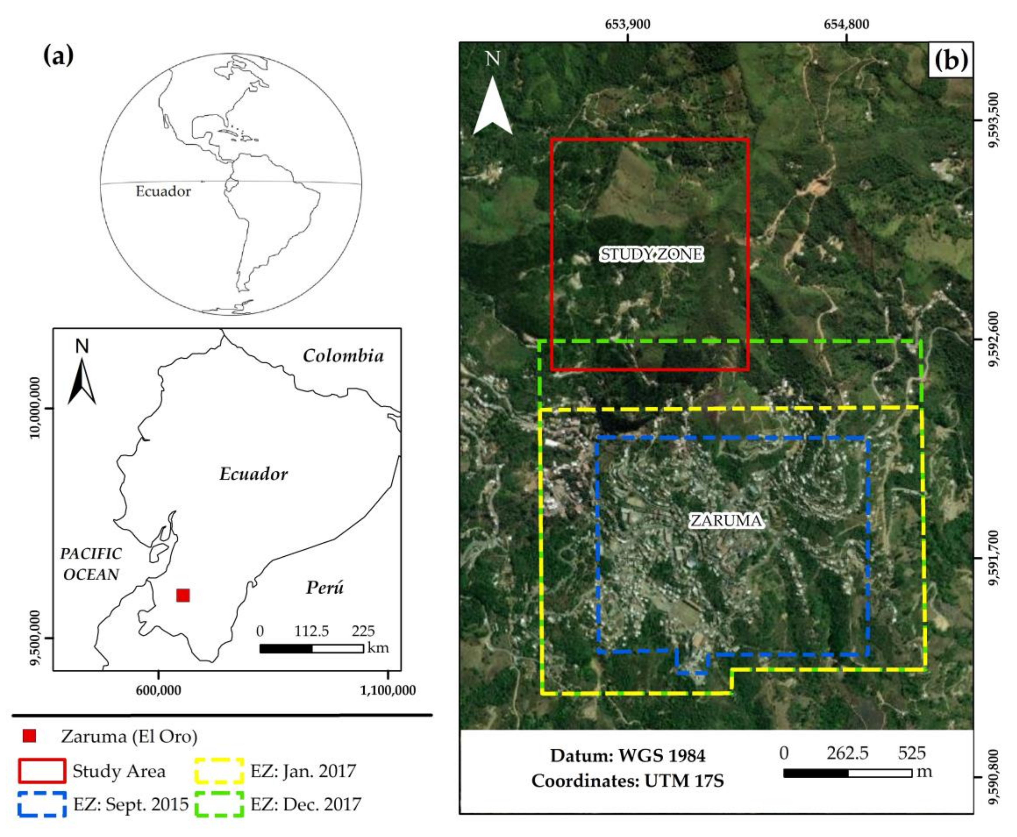
2. Study Area
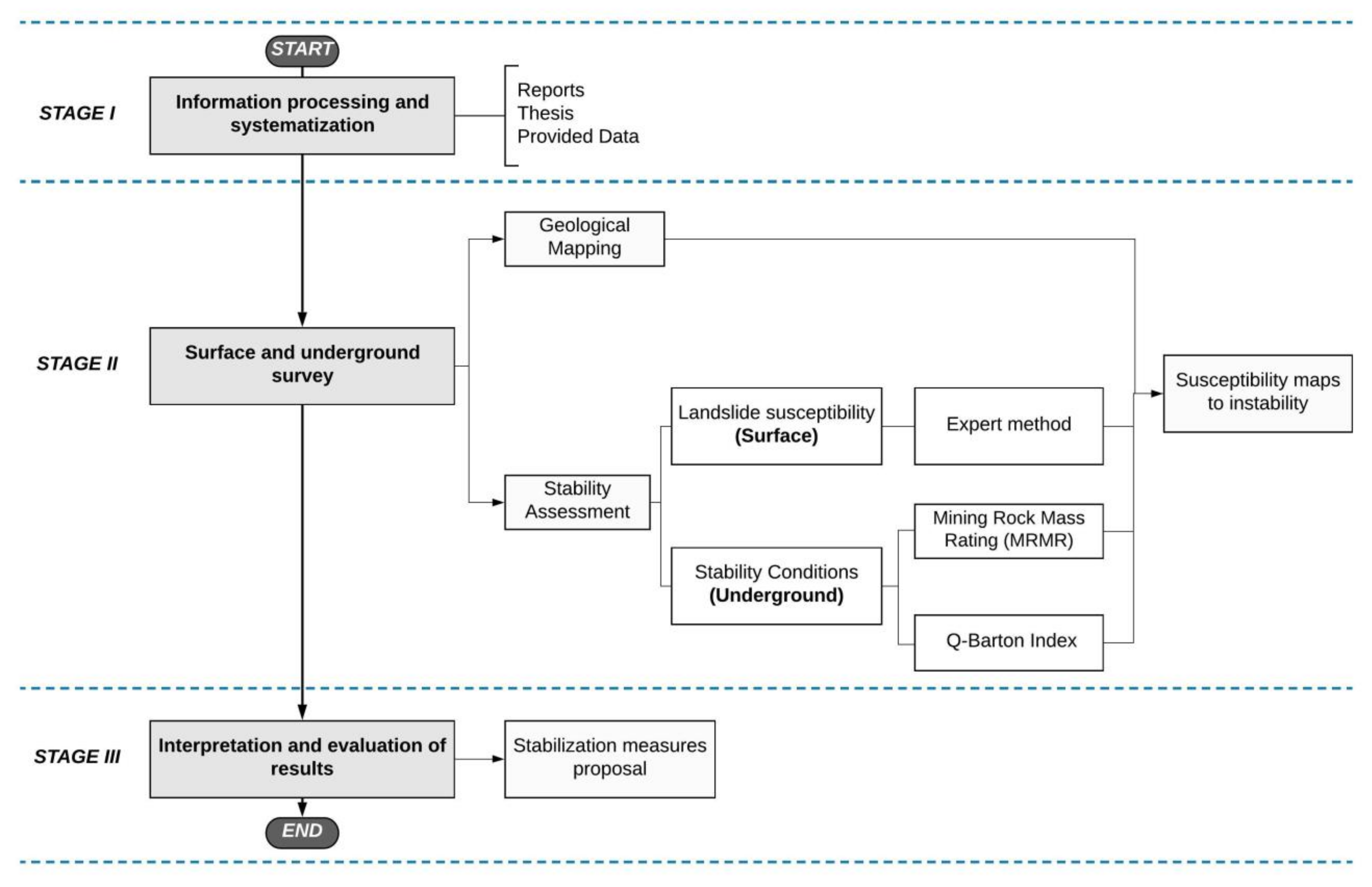
3. Materials and Methods
3.1. Stage I: Information Processing and Systematization
3.2. Stage II: Surface and Underground Survey
3.2.1. Surface Characterization
3.2.2. Underground Characterization
Q-Barton Index
Mining Rock Mass Rating (MRMR)
3.3. Stage III: Interpretation of Results and Stabilization Proposals
4. Results
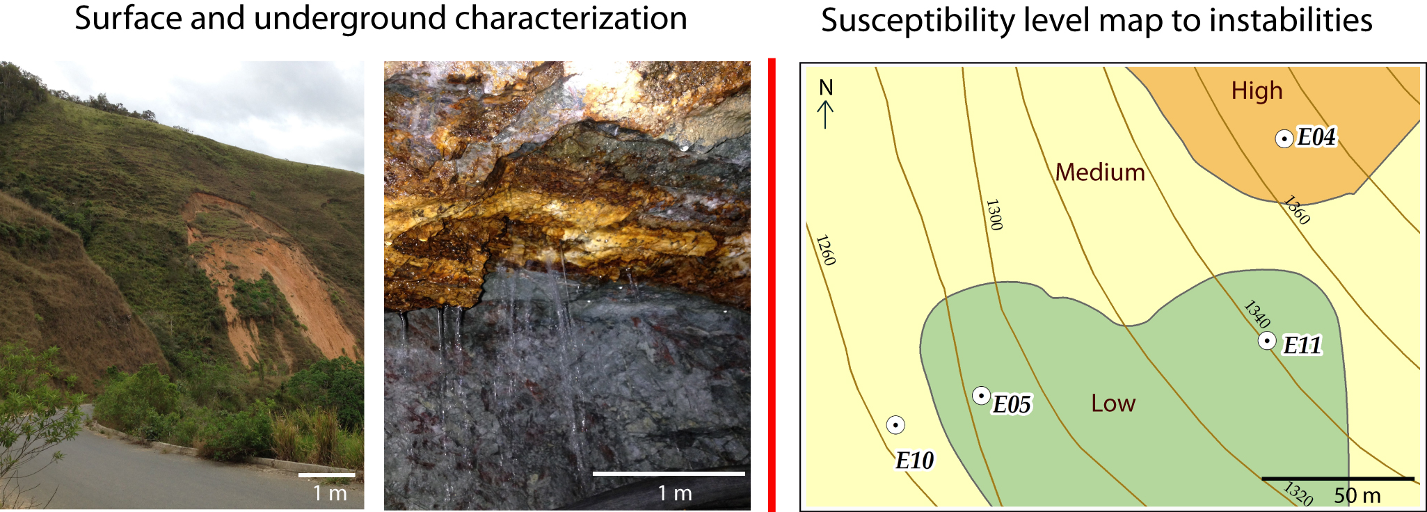
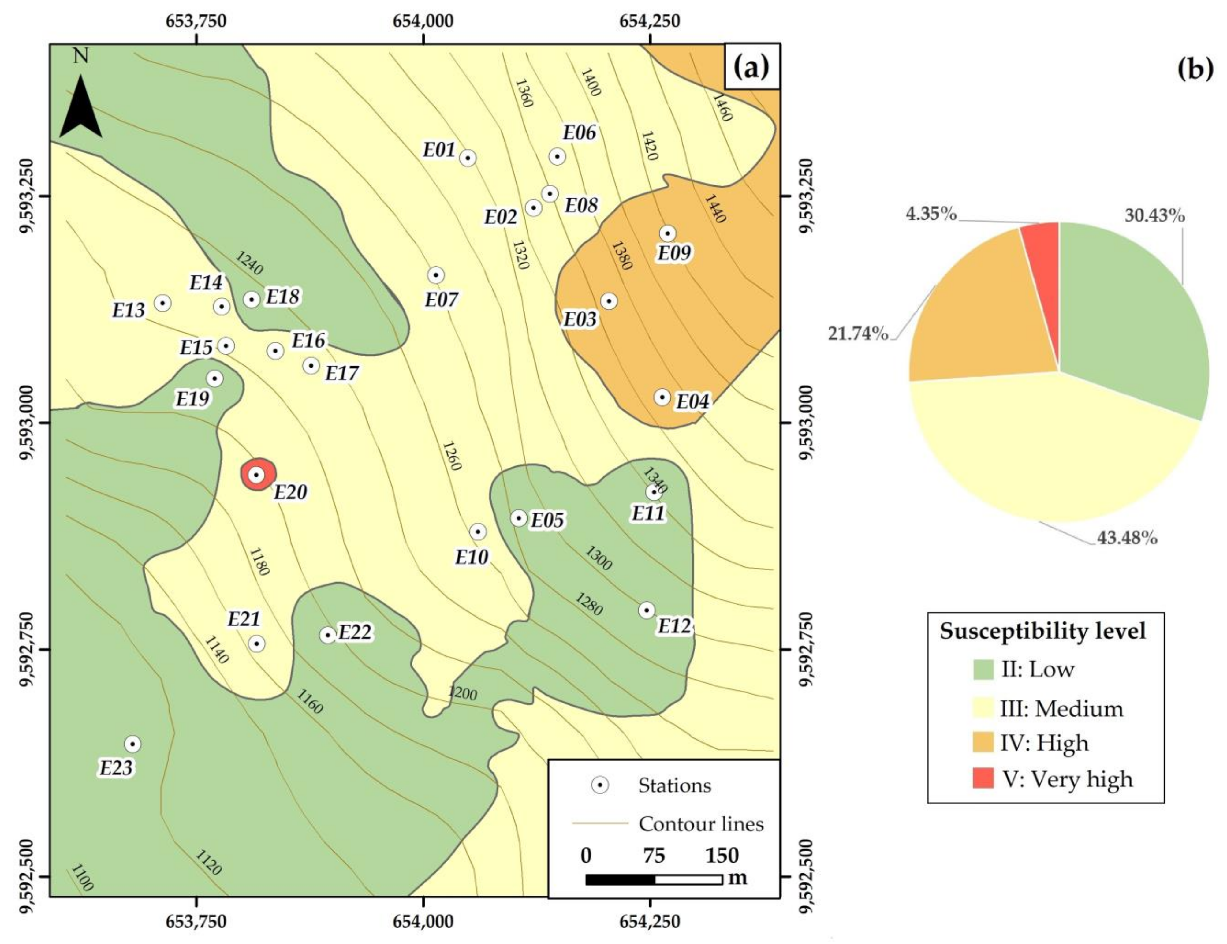
4.1. Surface Characterization
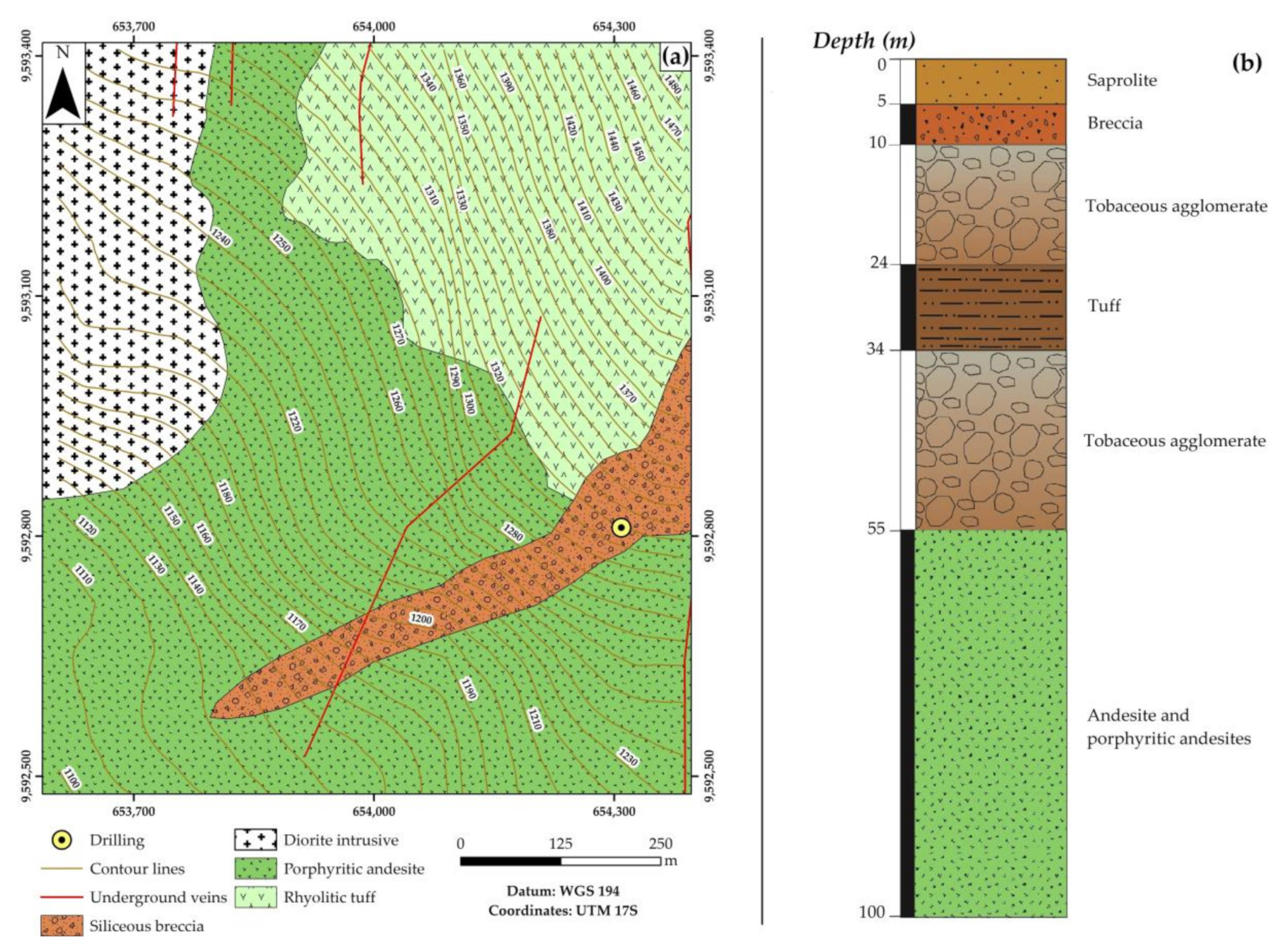
4.1.1. Geological Characterization
4.1.2. Lithological Sampling and Characterization
4.2. Underground Characterization
4.2.1. Geological Characterization
4.2.2. Geomechanical Characterization
5. Interpretation of Results and Discussion
- In surface areas with high susceptibility to instability (susceptibility levels IV and V), it is recommended to improve the surface drainage system, prepare a reforestation plan, and restrict urban development. Illegal mining activities must be stopped to avoid endangering the population.
- In underground areas susceptible to instabilities (susceptibility level above III), it is recommended to improve the water drainage systems in all galleries, use better methods and materials to support gallery ceilings, and use the filling of sterile chambers in addition to the support pillars.
- In the closest areas to the urban area, it is recommended to extend the study with additional surface and underground geomechanical stations to obtain a metric scale susceptibility model.
6. Conclusions
Supplementary Materials
Author Contributions
Funding
Institutional Review Board Statement
Informed Consent Statement
Data Availability Statement
Acknowledgments
Conflicts of Interest
References
- Van Dao, D.; Jaafari, A.; Bayat, M.; Mafi-Gholami, D.; Qi, C.; Moayedi, H.; Van Phong, T.; Ly, H.-B.; Le, T.-T.; Trinh, P.T.; et al. A spatially explicit deep learning neural network model for the prediction of landslide susceptibility. Catena 2020, 188, 104451. [Google Scholar] [CrossRef]
- Corominas, J.; Moya, J. A review of assessing landslide frequency for hazard zoning purposes. Eng. Geol. 2008, 102, 193–213. [Google Scholar] [CrossRef]
- Van Westen, C.J. The Modelling of Landslide Hazards Using GIS. Surv. Geophys. 2000, 21, 241–255. [Google Scholar] [CrossRef]
- Akbar, F.; Asupyani, H.; Azizi, H.A. Geological Hazards Interpretation Using Remote Sensing Method in Cimahi District, Kuningan Region, West Java. IOP Conf. Ser. Earth Environ. Sci. 2020, 412, 012022. [Google Scholar] [CrossRef]
- Yang, W.; Ding, R.; Zhou, Z.; Li, L.; Shi, S.; Wang, M.; Zhang, Q.; Geng, Y. Improved Attribute Interval Evaluation Theory for Risk Assessment of Geological Disasters in Underground Engineering and Its Application. Geotech. Geol. Eng. 2020, 38, 2465–2477. [Google Scholar] [CrossRef]
- Sousa, R.L.; Einstein, H.H. Risk analysis during tunnel construction using Bayesian Networks: Porto Metro case study. Tunn. Undergr. Space Technol. 2012, 27, 86–100. [Google Scholar] [CrossRef]
- Scavia, C.; Barbero, M.; Castelli, M.; Marchelli, M.; Peila, D.; Torsello, G.; Vallero, G. Evaluating Rockfall Risk: Some Critical Aspects. Geosciences 2020, 10, 98. [Google Scholar] [CrossRef]
- De Rienzo, F.; Oreste, P.; Pelizza, S. Subsurface geological-geotechnical modelling to sustain underground civil planning. Eng. Geol. 2008, 96, 187–204. [Google Scholar] [CrossRef]
- Bell, F.G.; Donnelly, L.J.; Genske, D.D.; Ojeda, J. Unusual cases of mining subsidence from Great Britain, Germany and Colombia. Environ. Earth Sci. 2004, 47, 620–631. [Google Scholar] [CrossRef]
- Ng, A.H.-M.; Ge, L.; Li, X.; Abidin, H.Z.; Andreas, H.; Zhang, K. Mapping land subsidence in Jakarta, Indonesia using persistent scatterer interferometry (PSI) technique with ALOS PALSAR. Int. J. Appl. Earth Obs. Geoinf. 2012, 18, 232–242. [Google Scholar] [CrossRef]
- Primanita, A. Jakarta Areas Muara Baru, Cengkareng Sinking Fast. Jakarta Globe. 2010. Available online: http://www.thejakartaglobe.com/archive/jakarta-areas-muara-baru-cengkareng-sinking-fast/ (accessed on 20 December 2020).
- Cappadonia, C.; Di Maggio, C.; Agate, M.; Agnesi, V. Geomorphology of the urban area of Palermo (Italy). J. Maps 2020, 16, 274–284. [Google Scholar] [CrossRef]
- Du, Z.; Ge, L.; Ng, A.H.-M.; Li, X. Investigation on mining subsidence over Appin–West Cliff Colliery using time-series SAR interferometry. Int. J. Remote Sens. 2017, 39, 1528–1547. [Google Scholar] [CrossRef]
- Sánchez, J.R.B. Paul J. Crutzen: A Pioneer on Atmospheric Chemistry and Climate Change in the Anthropocene. Ambix 2016, 63, 359–360. [Google Scholar] [CrossRef]
- Cooper, A.H.; Brown, T.J.; Price, S.J.; Ford, J.R.; Waters, C.N. Humans are the most significant global geomorphological driving force of the 21st century. Anthr. Rev. 2018, 5, 222–229. [Google Scholar] [CrossRef]
- Carrión-Mero, P.; Loor-Oporto, O.; Andrade-Ríos, H.; Herrera-Franco, G.; Morante-Carballo, F.; Jaya-Montalvo, M.; Aguilar-Aguilar, M.; Torres-Peña, K.; Berrezueta, E. Quantitative and Qualitative Assessment of the “El Sexmo” Tourist Gold Mine (Zaruma, Ecuador) as A Geosite and Mining Site. Resources 2020, 9, 28. [Google Scholar] [CrossRef]
- Mert, Y. Contribution to sustainable development: Re-development of post-mining brownfields. J. Clean. Prod. 2019, 240, 118212. [Google Scholar] [CrossRef]
- Mancini, L.; Sala, S. Social impact assessment in the mining sector: Review and comparison of indicators frameworks. Resour. Policy 2018, 57, 98–111. [Google Scholar] [CrossRef]
- Cao, X. Regulating mine land reclamation in developing countries: The case of China. Land Use Policy 2007, 24, 472–483. [Google Scholar] [CrossRef]
- Gutierrez, F.; Ortí, F.; Gutiérrez, M.; Pérez-González, A.; Benito, G.; Prieto, J.G.; Valsero, J.J.D. The stratigraphical record and activity of evaporite dissolution subsidence in Spain. Carbonates Evaporites 2001, 16, 46–70. [Google Scholar] [CrossRef]
- Mancini, F.; Stecchi, F.; Gabbianelli, G. GIS-based assessment of risk due to salt mining activities at Tuzla (Bosnia and Herzegovina). Eng. Geol. 2009, 109, 170–182. [Google Scholar] [CrossRef]
- Mancini, F.; Stecchi, F.; Zanni, M.; Gabbianelli, G. Monitoring ground subsidence induced by salt mining in the city of Tuzla (Bosnia and Herzegovina). Environ. Earth Sci. 2008, 58, 381–389. [Google Scholar] [CrossRef]
- Stecchi, F.; Antonellini, M.; Gabbianelli, G. Curvature analysis as a tool for subsidence-related risk zones identification in the city of Tuzla (BiH). Geomorphology 2009, 107, 316–325. [Google Scholar] [CrossRef]
- Crane, W. Subsidence and Ground Movement in the Copper and Iron Mines of the Upper Peninsula, Michigan; US Government Printing Office: Washington, DC, USA, 1929.
- Marschalko, M.; Třeslín, L. Impact of underground mining to slope deformation genesis at Doubrava Ujala. Acta Montan. Slovaca 2009, 14, 232–240. [Google Scholar]
- Palchik, V. Prediction of hollows in abandoned underground workings at shallow depth. Geotech. Geol. Eng. 2000, 18, 39–51. [Google Scholar] [CrossRef]
- Bauer, R.A.; Trent, B.A.; Dumontelle, P.B. Mine Subsidence in Illinois: Facts for Homeowners; Illinois State Geological Survey, Prairie Research Institute: Champaign, IL, USA, 1993. [Google Scholar]
- Perski, Z.; Jura, D. Identification and measurement of mining subsidence with SAR interferometry: Potentials and limitations. In Proceedings of the 11th FIG Symposium on Deformation Measurements, Santorini, Greece, 25–28 May 2003; pp. 1–7. [Google Scholar]
- Doyle, J. Notes on the salt mine of Duncrue. Trans. Geol. Soc. Dublin 1853, 5, 232–236. [Google Scholar]
- Donnelly, L.J. Nevado del Ruiz Volcano, Galeras Volcano and the Manizales Volcanological & Seismological Observatory, Colombia, South America. Br. Geol. Surv. 1997, 47, 620–631. [Google Scholar] [CrossRef]
- Antonio-Carpio, R.G.; Pérez-Flores, M.A.; Camargo-Guzmán, D.; Alanís-Alcantar, A. Use of resistivity measurements to detect urban caves in Mexico City and to assess the related hazard. Nat. Hazards Earth Syst. Sci. 2004, 4, 541–547. [Google Scholar] [CrossRef]
- Perissin, D.; Wang, T. Time-Series InSAR Applications over Urban Areas in China. IEEE J. Sel. Top. Appl. Earth Obs. Remote Sens. 2011, 4, 92–100. [Google Scholar] [CrossRef]
- Abidin, H.Z.; Andreas, H.; Gumilar, I.; Sidiq, T.P.; Gamal, M. Environmental Impacts of Land Subsidence in Urban Areas of Indonesia. In Proceedings of the FIG Working Week 2015: From the Wisdom of the Ages to the Challenges of Modern World, Sofia, Bulgaria, 17–21 May 2015; pp. 17–21. [Google Scholar]
- Barton, N.; Lien, R.; Lunde, J. Engineering classification of rock masses for the design of tunnel support. Rock Mech. Rock Eng. 1974, 6, 189–236. [Google Scholar] [CrossRef]
- Laubscher, D.H. Class distinction in rock masses. Coal. Gold Base Min. 1975, 23, 37–50. [Google Scholar]
- Zarroca, M.; Linares, R.; Velásquez-López, P.C.; Roqué, C.; Rodriguez, R.F. Application of electrical resistivity imaging (ERI) to a tailings dam project for artisanal and small-scale gold mining in Zaruma-Portovelo, Ecuador. J. Appl. Geophys. 2015, 113, 103–113. [Google Scholar] [CrossRef]
- Vidal Montes, R.; Martinez-Graña, A.M.; Martínez Catalán, J.R.; Ayarza Arribas, P.; Sánchez San Román, F.J. Vulnerability to groundwater contamination, SW salamanca, Spain. J. Maps 2016, 12, 147–155. [Google Scholar] [CrossRef]
- Martinez-Graña, A.M.; Goy, J.L.; Cimarra, C. 2D to 3D geologic mapping transformation using virtual globes and flight simulators and their applications in the analysis of geodiversity in natural areas. Environ. Earth Sci. 2014, 73, 8023–8034. [Google Scholar] [CrossRef]
- Roccati, A.; Paliaga, G.; Luino, F.; Faccini, F.; Turconi, L. GIS-Based Landslide Susceptibility Mapping for Land Use Planning and Risk Assessment. Land 2021, 10, 162. [Google Scholar] [CrossRef]
- Sestraș, P.; Bilașco, Ș.; Roșca, S.; Naș, S.; Bondrea, M.; Gâlgău, R.; Vereș, I.; Sălăgean, T.; Spalević, V.; Cîmpeanu, S. Landslides Susceptibility Assessment Based on GIS Statistical Bivariate Analysis in the Hills Surrounding a Metropolitan Area. Sustainability 2019, 11, 1362. [Google Scholar] [CrossRef]
- Marsala, V.; Galli, A.; Paglia, G.; Miccadei, E. Landslide Susceptibility Assessment of Mauritius Island (Indian Ocean). Geosciences 2019, 9, 493. [Google Scholar] [CrossRef]
- Erdogan, H.; Duzgun, H.; Selcuk-Kestel, A. Quantitative hazard assessment for Zonguldak Coal Basin underground mines. Int. J. Min. Sci. Technol. 2019, 29, 453–467. [Google Scholar] [CrossRef]
- dos Santos, T.B.; Lana, M.S.; Pereira, T.M.; Canbulat, I. Quantitative hazard assessment system (Has-Q) for open pit mine slopes. Int. J. Min. Sci. Technol. 2019, 29, 419–427. [Google Scholar] [CrossRef]
- Bhattacharya, A.; Arora, M.K.; Sharma, M.L. Usefulness of synthetic aperture radar (SAR) interferometry for digital elevation model (DEM) generation and estimation of land surface displacement in Jharia coal field area. Geocarto Int. 2012, 27, 57–77. [Google Scholar] [CrossRef]
- Morante Carballo, F.; Carrión Mero, P.; Ángel Chávez, M.; Aguilar Aguilar, M.; Briones Bitar, J. Design of the stabilization solutions in the general patrimonial cemetery of Guayaquil, Ecuador. In Proceedings of the 17th LACCEI International for Multi-Conference for Engineering, Education, and Technology: “Industry, Innovaiton, and Infrastructure for Sustainable Cities Communities”, Montego Bay, Jamaica, 24–26 July 2019. [Google Scholar]
- Lane, K. Unlucky strike: Gold and labor in Zaruma, Ecuador, 1699–1820. Colon. Lat. Am. Rev. 2004, 13, 65–84. [Google Scholar] [CrossRef]
- Velásquez-López, P.C.; Veiga, M.M.; Hall, K. Mercury balance in amalgamation in artisanal and small-scale gold mining: Identifying strategies for reducing environmental pollution in Portovelo-Zaruma, Ecuador. J. Clean. Prod. 2010, 18, 226–232. [Google Scholar] [CrossRef]
- Carrión Mero, P.; Blanco Torrens, R.; Borja Bernal, C.; Aguilar Aguilar, M.; Morante Carballo, F.; Briones Bitar, J. Geomechanical characterization and analysis of the effects of rock massif in Zaruma City, Ecuador. In Proceedings of the 17th LACCEI International for Multi-Conference for Engineering, Education, and Technology: “Industry, Innovaiton, and Infrastructure for Sustainable Cities Communities”, Montego Bay, Jamaica, 24–26 July 2019. [Google Scholar]
- Jácome, M.C.; Martinez-Graña, A.M.; Valdés, V. Detection of Terrain Deformations Using InSAR Techniques in Relation to Results on Terrain Subsidence (Ciudad de Zaruma, Ecuador). Remote Sens. 2020, 12, 1598. [Google Scholar] [CrossRef]
- Vangsnes, G.F. The meanings of mining: A perspective on the regulation of artisanal and small-scale gold mining in southern Ecuador. Extr. Ind. Soc. 2018, 5, 317–326. [Google Scholar] [CrossRef]
- Ammirati, L.; Mondillo, N.; Rodas, R.A.; Sellers, C.; Di Martire, D. Monitoring Land Surface Deformation Associated with Gold Artisanal Mining in the Zaruma City (Ecuador). Remote Sens. 2020, 12, 2135. [Google Scholar] [CrossRef]
- Agencia de Regulación y Control Minero. Ministerio de Minería Amplía Zona de Exclusión de Zaruma. Available online: www.controlminero.gob.ec/ministerio-de-mineria-amplia-zona-de-exclusion-de-zaruma/#:~:text=El%20Ministerio%20de%20Mi-ner%C3%ADa%20firm%C3%B3,El%20Oro%2C%20a%20173%20hect%C3%A1reas (accessed on 20 December 2020).
- Franco, G.H.; Mero, P.C.; Carballo, F.M.; Narváez, G.H.; Bitar, J.B.; Torrens, R.B. Strategies for the development of the value of the mining-industrial heritage of the Zaruma-Portovelo, ecuador, in the context of a geopark project. Int. J. Energy Prod. Manag. 2020, 5, 48–59. [Google Scholar] [CrossRef]
- Esri World Imagery. Available online: http://goto.arcgisonline.com/maps/World_Imagery (accessed on 20 December 2020).
- Van Thournout, F.; Salemink, J.; Valenzuela, G.; Merlyn, M.; Boven, A.; Muchez, P. Portovelo: A volcanic-hosted epithermal vein-system in Ecuador, South America. Miner. Depos. 1996, 31, 269–276. [Google Scholar] [CrossRef]
- La Misión Británica y la Dirección General de Geología y Minas. Hoja Geológica Zaruma 38 CT-NVI-E Escala 1:100,000; Instituto de Investigación Geológico y Energético, Ministerio de Recursos Naturales y Energéticos, Dirección General de Geología y Minas: Quito, Ecuador, 1980. [Google Scholar]
- Chiaradia, M.; Fontboté, L.; Beate, B. Cenozoic continental arc magmatism and associated mineralization in Ecuador. Miner. Depos. 2004, 39, 204–222. [Google Scholar] [CrossRef]
- Berrezueta, E.; Ordóñez-Casado, B.; Bonilla, W.; Banda, R.; Castroviejo, R.; Carrión, P.; Puglla, S. Ore Petrography Using Optical Image Analysis: Application to Zaruma-Portovelo Deposit (Ecuador). Geosciences 2016, 6, 30. [Google Scholar] [CrossRef]
- Bonilla, W. Metalogenia del Distrito Minero Zaruma-Portovelo, República del Ecuador. Ph.D. Thesis, Universidad de Buenos Aires, Buenos Aires, Argentina, 2009. [Google Scholar]
- Sauer, W. Geología del Ecuador; Editorial Talleres Gráficos del Ministerio de Educación: Quito, Ecuador, 1965. [Google Scholar]
- Sánchez Padilla, C.V.; Sánchez Zambrano, A.J. Evaluación de Amenazas Geodinámicas en el Entorno de la Actividad Minera en la Concesión Minera Palacios (Tesis de Grado); Escuela Superior Politécnica del Litoral: Guayaquil, Ecuador, 2019. [Google Scholar]
- Blanco, R. Estudios de la Zona de Exclusión Minera en los Cantones Zaruma-Portovelo: Caso concesiones mineras Esperanza II y Palacios. In Informe Geotécnico; CIPAT-ESPOLTECH E.P.: Guayaquil, Ecuador, 2018. [Google Scholar]
- Secretaría de Gestión de Riesgos (SGR) Proyecto. Perforaciones Geotécnicas en el Área de Interés del Casco Urbano de la Ciudad de Zaruma, Provincia de El Oro; Secretaría de Gestión de Riesgos (SGR) Proyecto: Quito, Ecuador, 2018. [Google Scholar]
- Morante, F. Estudios de la Zona de Exclusión Minera en los Cantones Zaruma-Portovelo: Caso Concesiones Mineras La Esperanza II y Palacios. In Informe Geológico; CIPAT-ESPOLTECH E.P.: Guayaquil, Ecuador, 2018. [Google Scholar]
- Blanco, R. Estudios y Propuestas de Estabilización del Cerro Las Cabras; CIPAT-ESPOL: Guayaquil, Ecuador, 2015. [Google Scholar]
- Nicholson, D.T.; Hencher, S. Assessing the potential for deterioration of engineered rockslopes. In Proceedings of the Engineering Geology and the Environment, Athens, Greece, 23–27 June 1997; Volume 1, pp. 911–917. [Google Scholar]
- Anbalagan, R. Terrain evaluation and landslide hazard zonation for environmental regeneration and land use planning in mountainous terrain. In Proceedings of the International Symposium on Landslides, Rotterdam, The Netherlands, 10–14 February 1992; Volume 6, pp. 861–869. [Google Scholar]
- Brand, E.W.; Phillipson, H.B. Sampling and testing of residual soils. In A Review of International Practice; Hong Kong Scorpion Press: Hong Kong, China, 2015. [Google Scholar]
- Suarez, J. Deslizamientos y Estabilidad de Taludes en Zonas Tropicales; Instituto de Investigaciones sobre Erosión y Deslizamientos: Bucaramanga, Colombia, 1998. [Google Scholar]
- Morgenstern, N.R.; Price, V.E. The Analysis of the Stability of General Slip Surfaces. Géotechnique 1965, 15, 79–93. [Google Scholar] [CrossRef]
- Morante, F.; Aguilar, M.; Ramírez, G.; Blanco, R.; Carrión, P.; Briones, J.; Berrezueta, E. Evaluation of Slope Stability Considering the Preservation of the General Patrimonial Cemetery of Guayaquil, Ecuador. Geosciences 2019, 9, 103. [Google Scholar] [CrossRef]
- Deere, D.U.; Deere, D.W. Rock Quality Designation (RQD) after Twenty Years; Geotechnical Laboratory, US Army Engineer Waterways Experiment Station: Vicksburg, MS, USA, 1988. [Google Scholar]
- Priest, S.; Hudson, J. Discontinuity spacings in rock. Int. J. Rock Mech. Min. Sci. Géoméch. Abstr. 1976, 13, 135–148. [Google Scholar] [CrossRef]
- Luo, Y.; Qiu, B. Identifying Root Causes for Subsidence over Abandoned Coal Mine–A Case Study. In Proceedings of the 47th U.S. Rock Mechanics/Geomechanics Symposium, San Francisco, CA, USA, 23–26 June 2013; p. 12. [Google Scholar]
- Cuervas-Mon, J.; Jordá-Bordehore, L.; Nazareno, J.A.; Escobar, K.F. Evaluation of the stability of small diameter mining excavations using geomechanical classifications and empirical analysis: The case of the San Juan mine, Ecuador. Trab. Geol. 2015, 35, 19–28. [Google Scholar] [CrossRef][Green Version]
- Jordá-Bordehore, L.; Jordá-Bordehore, R.; Valsero, J.J.D.; Romero-Crespo, P.L. Evaluación de la estabilidad de las labores y pilar corona en las minas abandonadas de S’Argentera (Ibiza, España) combinando clasificaciones geomecánicas, métodos empíricos y análisis numérico-enfocado a su posible aprovechamiento turístico. Boletín Geológico Min. 2017, 128, 3–24. [Google Scholar] [CrossRef]
- Bieniawski, Z.T. Engineering Rock Mass Classifications: A Complete Manual for Engineers and Geologists in Mining, Civil, and Petroleum Engineering; John Wiley & Sons: Hoboken, NJ, USA, 1989. [Google Scholar]
- Lee, S.; Park, I.; Choi, J.-K. Spatial Prediction of Ground Subsidence Susceptibility Using an Artificial Neural Network. Environ. Manag. 2012, 49, 347–358. [Google Scholar] [CrossRef] [PubMed]
- Laboratorio Oficial Madariaga-LOM. Guía Sobre Control Geotécnico en Minería Subterránea; Informe final. Proyecto 5.3.; LOM: Madrid, Spain, 2015. [Google Scholar]


| Parameters | Weight |
|---|---|
| Lithology (L) | 0 to 4 |
| Geological structure (Gs) | 0 to 4 |
| Morphometry (M) | 0 to 4 |
| Discontinuity (D) | 0 to 4 |
| Water (W) | 0 to 3 |
| Vegetable cover (Vc) | 0 to 3 |
| Seismic (S) | 0 to 4 |
| Weathering Rank (Wr) | 0 to 4 |
| SC: (L + Gs + M + D + W + Vc + S + Wr) | 0 to 30 |
| Susceptibility Level | Susceptibility Coefficient (SC) | Remark |
|---|---|---|
| I | Very low: SC < 5.0 | Stable conditions. |
| II | Low: 5 < SC < 10 | Stable conditions. Monitoring is required. |
| III | Medium: 10 < SC < 15 | Predominantly stable conditions. Systematic monitoring is required. |
| IV | High: 15 < SC < 20 | Potentially unstable conditions. |
| V | Very high: SC > 20 | Unstable conditions. |
| Q-Barton | Rock Massif Quality | Susceptibility Level * |
|---|---|---|
| 0.001–0.01 | Exceptionally poor | V |
| 0.01–0.1 | Extremely poor | V |
| 0.1–1 | Very poor | IV |
| 1–4 | Poor | IV |
| 4–10 | Fair | III |
| 10–40 | Good | II |
| 40–100 | Very good | II |
| 100–400 | Extremely good | I |
| 400–1000 | Exceptionally good | I |
| MRMR | Rock Massif Quality | Susceptibility Level * |
|---|---|---|
| 0–20 | Very poor | V |
| 20–40 | Poor | IV |
| 40–60 | Fair | III |
| 60–80 | Good | II |
| 80–100 | Very good | I |
| Station | Lithology (Original Rock) | Main Description |
|---|---|---|
| 1 | Rhyolitic tuff | Saprolite |
| 2 | Rhyolitic tuff | Rock somewhat weathered and with some weathering degree |
| 3 | Rhyolitic tuff | Saprolite |
| 4 | Rhyolitic tuff | Rock somewhat weathered and with some weathering degree |
| 5 | Porphyritic andesite | Rock somewhat weathered and with some weathering degree |
| 6,9 | Rhyolitic tuff | Saprolite |
| 7 | Rhyolitic tuff | Rock somewhat weathered and with some weathering degree |
| 8 | Rhyolitic tuff | Rock somewhat weathered and with some weathering degree |
| 10 | Porphyritic andesite | Saprolite |
| 11 | Rhyolitic tuff | Rock somewhat weathered and with some weathering degree |
| 12 | Siliceous breccia | Rock somewhat weathered and with some weathering degree |
| 13,14 | Diorite intrusive | Saprolite |
| 15 | Diorite intrusive | Rock somewhat weathered and with some weathering degree |
| 16 | Porphyritic andesite | Saprolite |
| 17,18 | Porphyritic andesite | Saprolite |
| 19 | Diorite intrusive | Rock somewhat weathered and with some weathering degree |
| 20 | Porphyritic andesite | Saprolite |
| 21,22,23 | Porphyritic andesite | Saprolite |
| Station | Susceptibility Coefficient | Susceptibility Level | Observations |
|---|---|---|---|
| 1 | 16.5 | IV | Potentially unstable conditions. |
| 2 | 12.5 | III | Predominantly stable conditions. Systematic monitoring is required. |
| 3 | 16 | IV | Potentially unstable conditions. |
| 4 | 16.5 | ||
| 5 | 9 | II | Stable conditions. Monitoring is required. |
| 6 | 16 | IV | Potentially unstable conditions. |
| 7 | 10.5 | III | Predominantly stable conditions. Systematic monitoring is required. |
| 8 | 10.5 | ||
| 9 | 12.5 | IV | Potentially unstable conditions. |
| 10 | 10.5 | III | Predominantly stable conditions. Systematic monitoring is required. |
| 11 | 6.5 | II | Stable conditions. Monitoring is required. |
| 12 | 5.5 | ||
| 13 | 9.5 | III | Predominantly stable conditions. Systematic monitoring is required. |
| 14 | 10 | ||
| 15 | 13 | ||
| 16 | 9.5 | ||
| 17 | 9 | ||
| 18 | 8 | II | Stable conditions. Monitoring is required. |
| 19 | 8 | ||
| 20 | 20.5 | V | Unstable conditions. |
| 21 | 14 | III | Predominantly stable conditions. Systematic monitoring is required. |
| 22 | 7.5 | II | Stable conditions. Monitoring is required. |
| 23 | 7.5 |
| Stations | Lithology (L) | General Description |
|---|---|---|
| 1,6 | Andesite | Slightly weathered and fractured andesite, with a greenish-grey hue. The rocky massif is fractured into blocks, with rough surfaces and little evidence of deterioration. |
| 2 | Microdiorite | Slightly deteriorated and fractured microdiorite, with rough surfaces without deterioration. Greenish-grey rock. |
| 3,4,8 | Andesite | Andesite without evidence of deterioration, of a greenish-grey hue. The rocky massif is moderately fractured, with fresh and rough surfaces. |
| 5,7 | Microdiorite | Microdiorite without deterioration, with a greenish-grey hue, presents few fractures with very rough surfaces and without deterioration. |
| 9 | Andesite with dioritic dike | Slightly deteriorated rock with a light green hue. The rocky massif has block fracturing and rough fracture surfaces with ferrous spots. |
| 10,13,16 | Porphyritic andesite | Slightly deteriorated rock with a greenish-grey hue, showing areas of mylonites. The rocky massif presents fracturing in blocks with rough surfaces and high deterioration. |
| 11 | Diorite | Slightly deteriorated rock with a greenish-gray hue, the rocky massif presents intense fracturing with rough surfaces without deterioration. |
| 12,17 | Rhyolitic tuff | Porous rocks slightly altered and deteriorated, with a pink hue. |
| 14,15 | Dioritic intrusive | Rock without deterioration, fractured with rough surfaces, of a greenish-gray hue. |
| Station | Jn | Jr | Ja | Jw | RQD (%) | SRF | Q-Barton Index | Qualitative Rating | Susceptibility Level |
|---|---|---|---|---|---|---|---|---|---|
| 1 | 4 | 2.00 | 2.00 | 1.00 | 94.72 | 1.00 | 23.68 | Good | II |
| 2 | 4 | 2.00 | 2.00 | 0.66 | 96.02 | 5.00 | 3.17 | Poor | IV |
| 3 | 5 | 2.00 | 0.80 | 1.00 | 90.21 | 1.00 | 45.11 | Very Good | II |
| 4 | 5 | 1.50 | 0.90 | 0.66 | 90.60 | 1.50 | 13.29 | Good | II |
| 5 | 9 | 2.00 | 0.90 | 0.50 | 82.66 | 1.50 | 7.20 | Fair | III |
| 6 | 3 | 1.50 | 2.00 | 0.50 | 96.31 | 1.00 | 12.04 | Good | II |
| 7 | 3 | 2.00 | 2.00 | 0.50 | 94.37 | 1.20 | 13.11 | Good | II |
| 8 | 9 | 1.50 | 2.00 | 0.33 | 90.21 | 1.00 | 2.48 | Poor | IV |
| 9 | 3 | 1.50 | 4.00 | 0.50 | 83.98 | 1.00 | 5.25 | Fair | III |
| 10 | 6 | 1.00 | 5.00 | 0.33 | 93.24 | 1.00 | 1.03 | Poor | IV |
| 11 | 3 | 2.00 | 1.50 | 0.66 | 94.72 | 1.00 | 27.79 | Good | II |
| 12 | 3 | 1.50 | 2.00 | 1.00 | 77.25 | 1.50 | 12.84 | Good | II |
| 13 | 5 | 1.50 | 2.00 | 0.50 | 81.39 | 1.00 | 6.08 | Fair | III |
| 14 | 3 | 1.50 | 2.00 | 0.33 | 88.63 | 1.00 | 7.34 | Fair | III |
| 15 | 7 | 1.50 | 2.00 | 0.50 | 79.07 | 1.00 | 4.23 | Fair | III |
| 16 | 9 | 1.50 | 2.00 | 0.33 | 87.81 | 1.00 | 2.42 | Poor | IV |
| 17 | 3 | 1.00 | 3.50 | 0.66 | 83.92 | 1.00 | 5.28 | Fair | III |
| Station | RMR | Cw | Co | Cs | Cb | MRMR | Qualitative Rating | Susceptibility Level |
|---|---|---|---|---|---|---|---|---|
| 1 | 68.80 | 0.94 | 0.90 | 1.20 | 1 | 69.87 | Good | II |
| 2 | 63.10 | 0.94 | 0.90 | 1.20 | 1 | 65.28 | Good | II |
| 3 | 66.50 | 1.00 | 0.90 | 1.20 | 1 | 71.92 | Good | II |
| 4 | 61.00 | 1.00 | 0.80 | 1.20 | 1 | 58.66 | Fair | III |
| 5 | 47.40 | 1.00 | 0.80 | 1.20 | 1 | 45.52 | Fair | III |
| 6 | 65.40 | 0.94 | 0.90 | 1.20 | 1 | 66.42 | Good | II |
| 7 | 65.20 | 1.00 | 0.90 | 1.20 | 1 | 70.44 | Good | II |
| 8 | 50.90 | 0.94 | 0.90 | 1.20 | 1 | 51.68 | Fair | III |
| 9 | 58.50 | 0.94 | 0.80 | 1.20 | 1 | 52.88 | Fair | III |
| 10 | 60.80 | 0.94 | 0.80 | 1.20 | 1 | 54.90 | Fair | III |
| 11 | 68.10 | 1.00 | 0.90 | 1.20 | 1 | 73.57 | Good | II |
| 12 | 52.30 | 0.94 | 0.90 | 1.20 | 1 | 53.12 | Fair | III |
| 13 | 51.90 | 0.94 | 0.9 | 1.2 | 1 | 52.70 | Fair | III |
| 14 | 51.90 | 0.94 | 0.9 | 1.2 | 1 | 52.76 | Fair | III |
| 15 | 47.70 | 0.94 | 0.9 | 1.2 | 1 | 48.53 | Fair | III |
| 16 | 46.50 | 0.94 | 0.9 | 1.2 | 1 | 47.28 | Fair | III |
| 17 | 50.00 | 0.76 | 0.9 | 1.2 | 1 | 41.10 | Fair | III |
Publisher’s Note: MDPI stays neutral with regard to jurisdictional claims in published maps and institutional affiliations. |
© 2021 by the authors. Licensee MDPI, Basel, Switzerland. This article is an open access article distributed under the terms and conditions of the Creative Commons Attribution (CC BY) license (http://creativecommons.org/licenses/by/4.0/).
Share and Cite
Carrión-Mero, P.; Aguilar-Aguilar, M.; Morante-Carballo, F.; Domínguez-Cuesta, M.J.; Sánchez-Padilla, C.; Sánchez-Zambrano, A.; Briones-Bitar, J.; Blanco-Torrens, R.; Córdova-Rizo, J.; Berrezueta, E. Surface and Underground Geomechanical Characterization of an Area Affected by Instability Phenomena in Zaruma Mining Zone (Ecuador). Sustainability 2021, 13, 3272. https://doi.org/10.3390/su13063272
Carrión-Mero P, Aguilar-Aguilar M, Morante-Carballo F, Domínguez-Cuesta MJ, Sánchez-Padilla C, Sánchez-Zambrano A, Briones-Bitar J, Blanco-Torrens R, Córdova-Rizo J, Berrezueta E. Surface and Underground Geomechanical Characterization of an Area Affected by Instability Phenomena in Zaruma Mining Zone (Ecuador). Sustainability. 2021; 13(6):3272. https://doi.org/10.3390/su13063272
Chicago/Turabian StyleCarrión-Mero, Paúl, Maribel Aguilar-Aguilar, Fernando Morante-Carballo, María José Domínguez-Cuesta, Cristhian Sánchez-Padilla, Andrés Sánchez-Zambrano, Josué Briones-Bitar, Roberto Blanco-Torrens, Javier Córdova-Rizo, and Edgar Berrezueta. 2021. "Surface and Underground Geomechanical Characterization of an Area Affected by Instability Phenomena in Zaruma Mining Zone (Ecuador)" Sustainability 13, no. 6: 3272. https://doi.org/10.3390/su13063272
APA StyleCarrión-Mero, P., Aguilar-Aguilar, M., Morante-Carballo, F., Domínguez-Cuesta, M. J., Sánchez-Padilla, C., Sánchez-Zambrano, A., Briones-Bitar, J., Blanco-Torrens, R., Córdova-Rizo, J., & Berrezueta, E. (2021). Surface and Underground Geomechanical Characterization of an Area Affected by Instability Phenomena in Zaruma Mining Zone (Ecuador). Sustainability, 13(6), 3272. https://doi.org/10.3390/su13063272