
The Productive Landscape in the Desert Margin for the Sustainable Development of Rural Settlements: An Innovative Greenbelt for Maranjab Desert in Iran


Abstract
1. Introduction
2. Materials and Methods
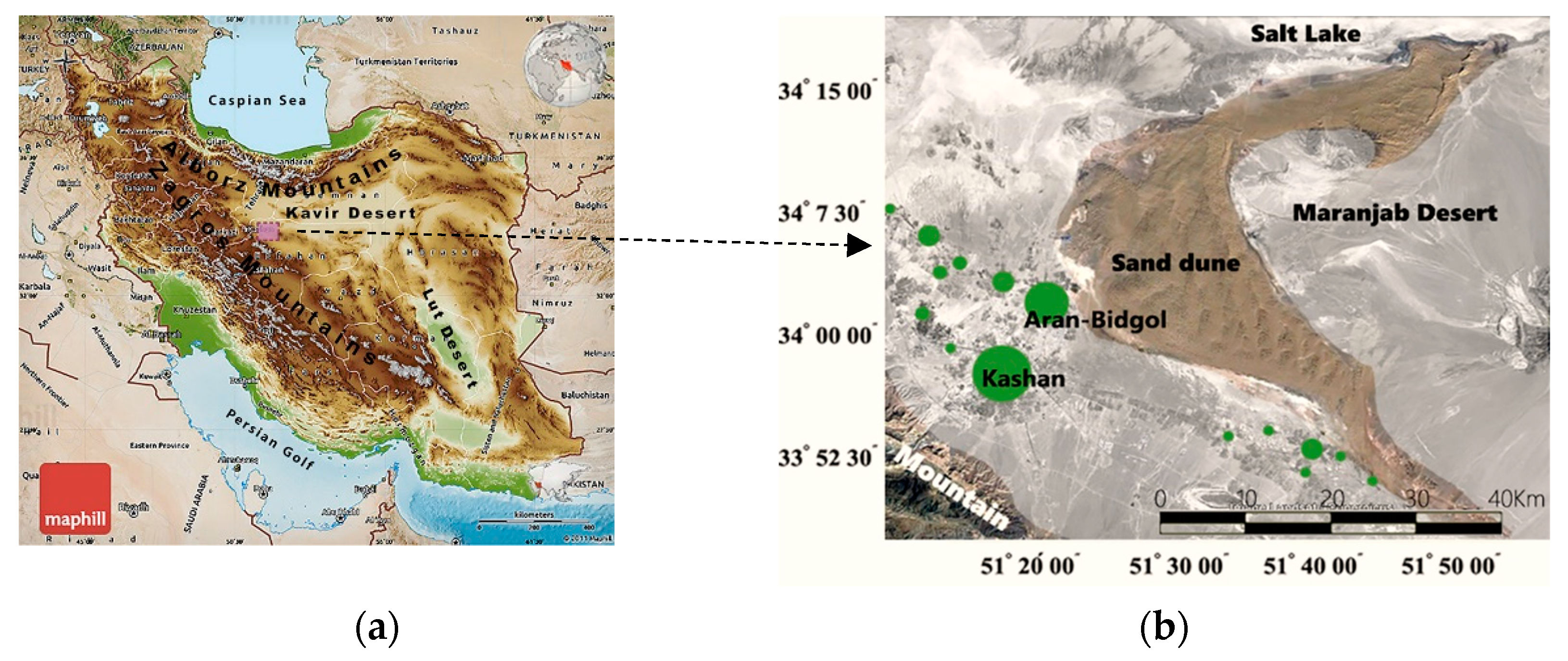
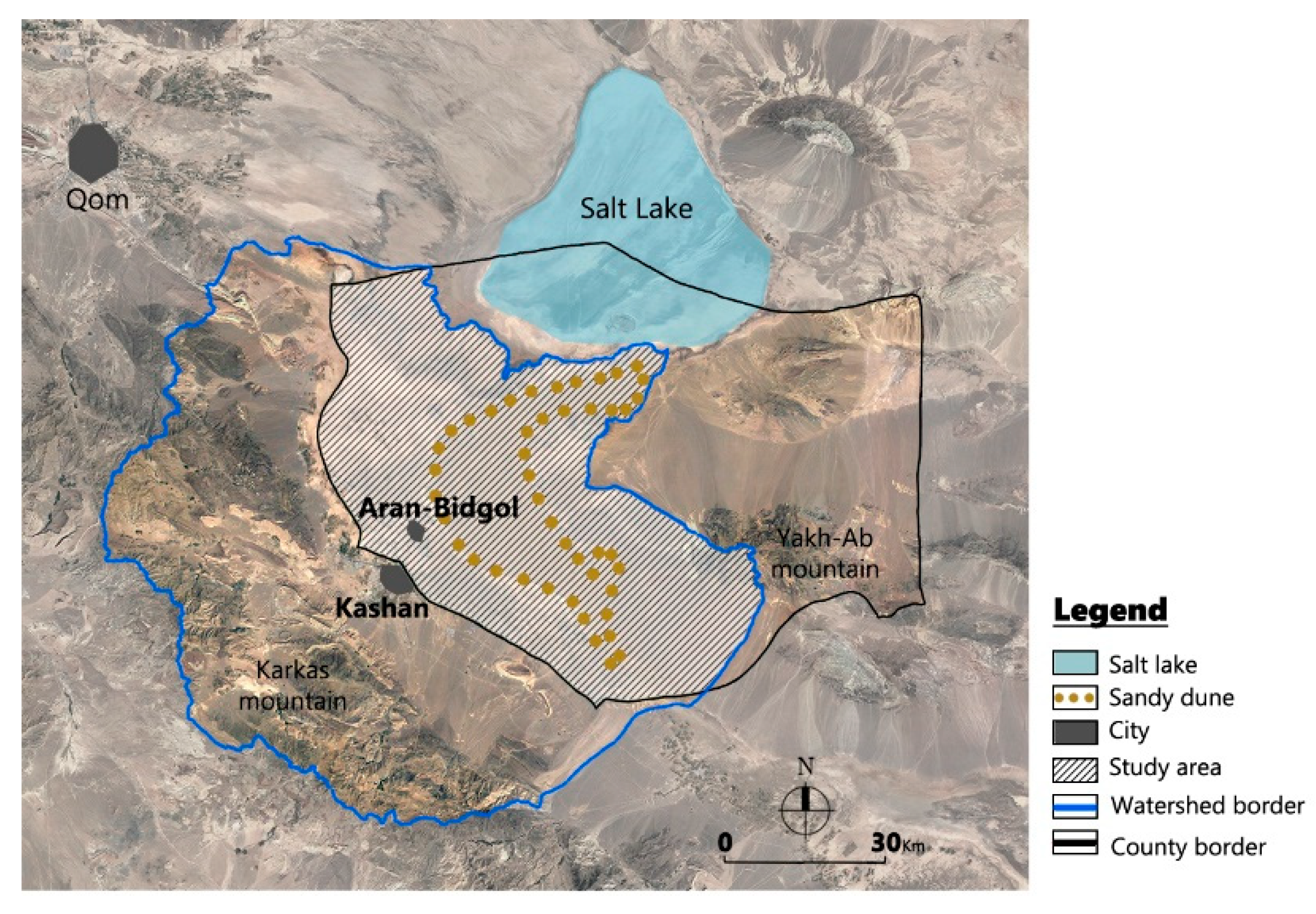
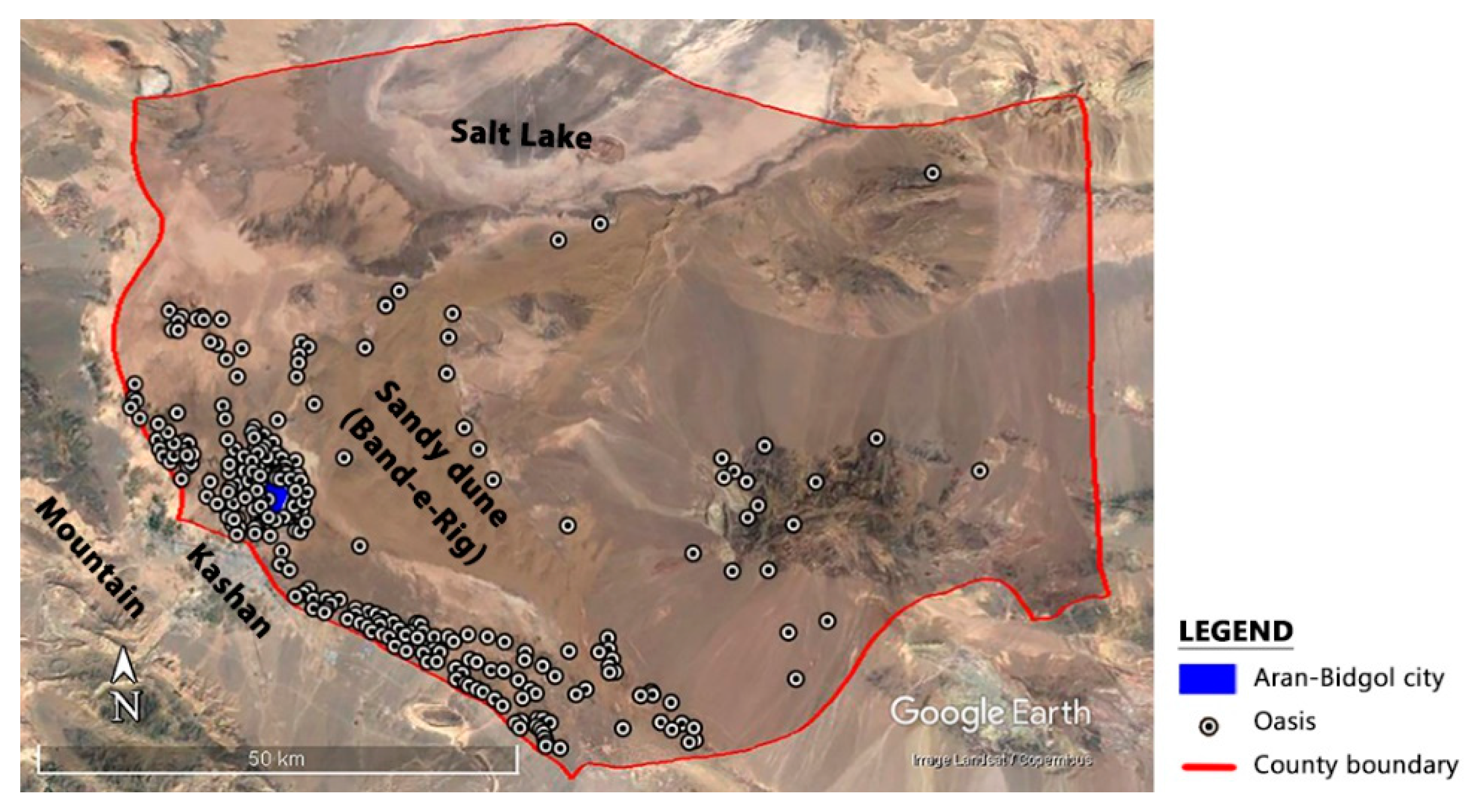
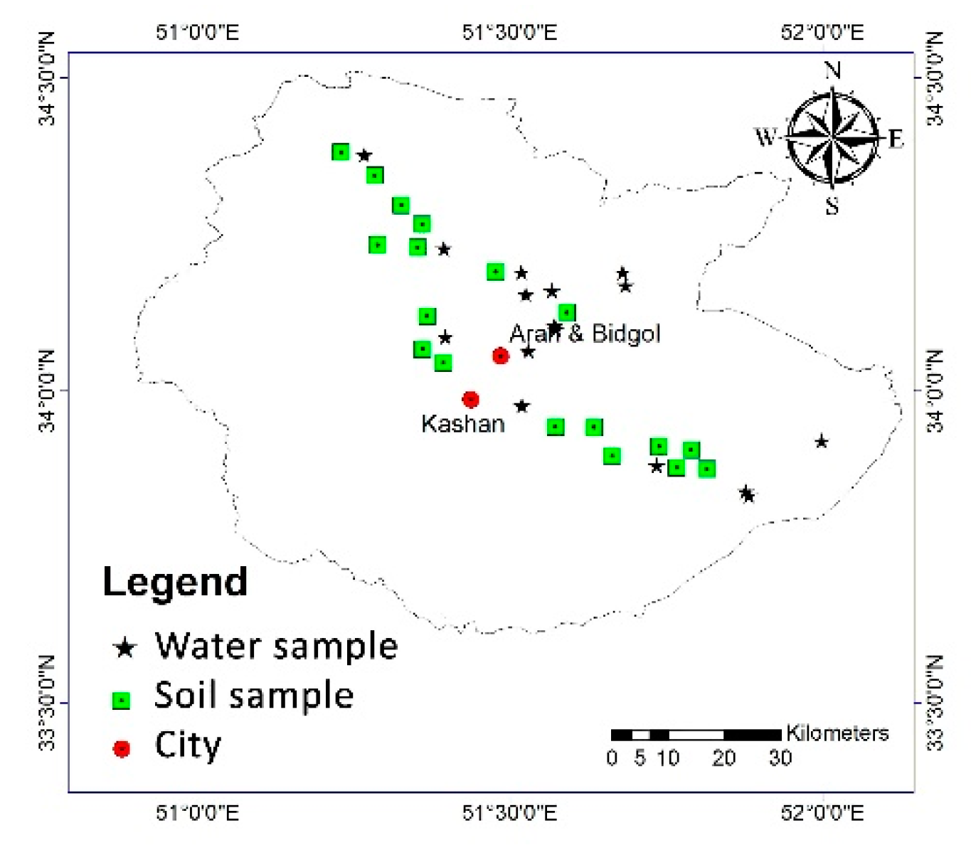
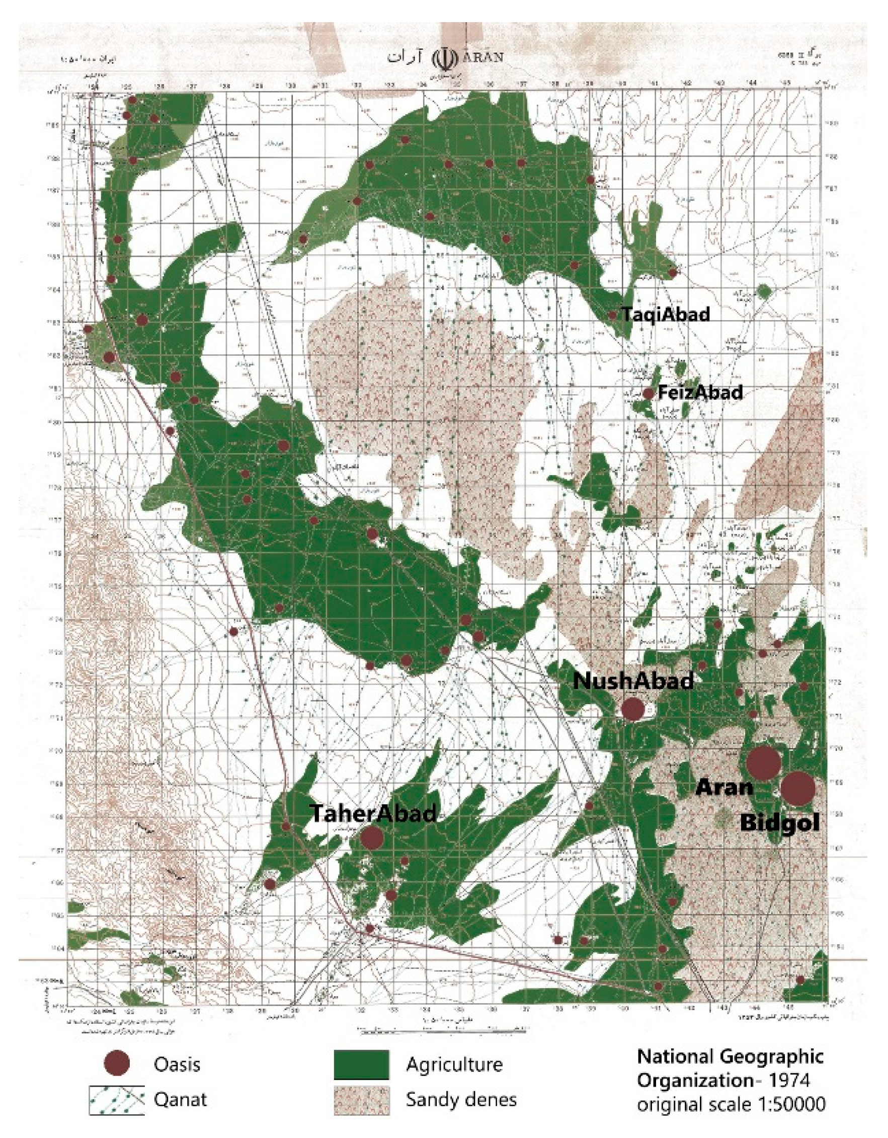
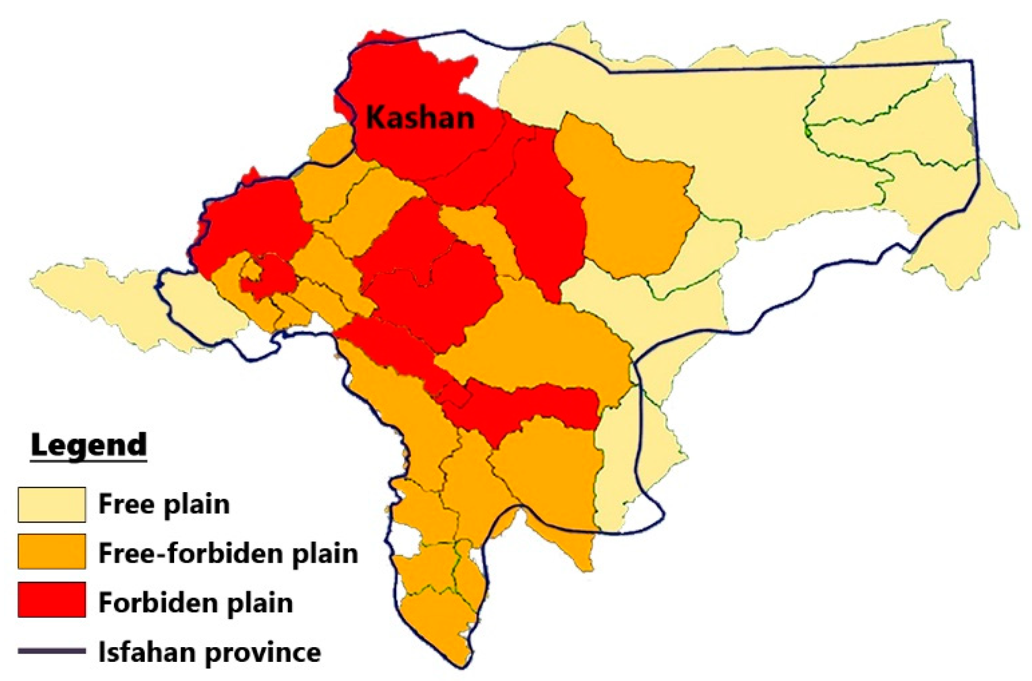
2.1. The Study Site
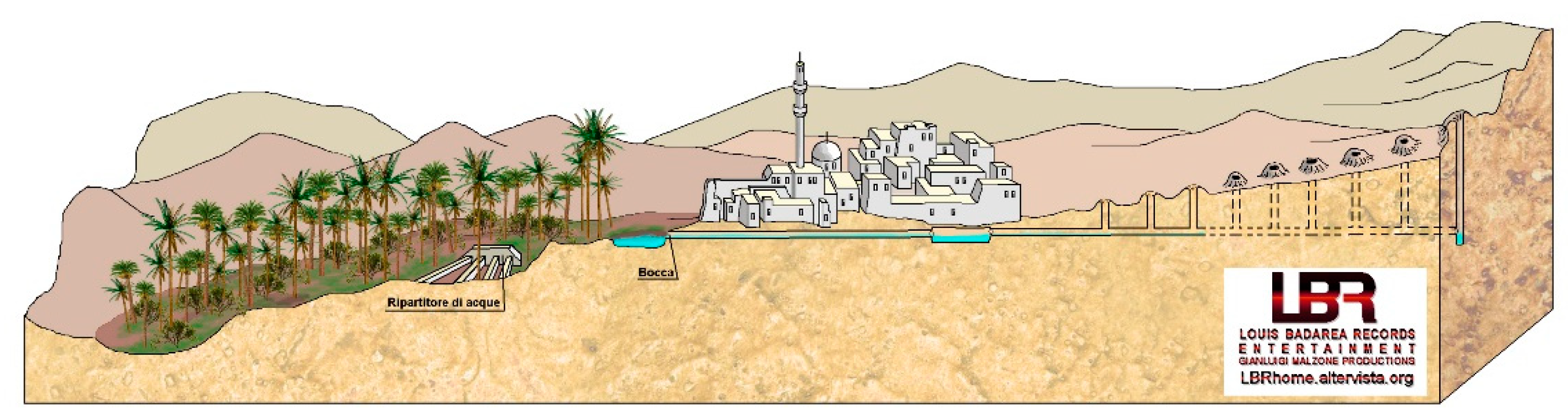
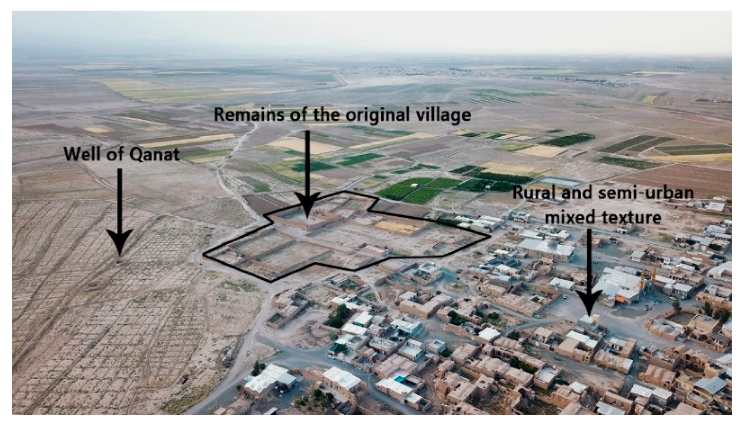
- A low-sloped underground horizontal channel from the foothills to the plain, which directs water from the groundwater table to the surface;
- A series of vertical wells that are used to ventilate the horizontal channel and also remove the excavated soil during the qanat construction from the underground, as well as the repair and restoration of the qanat (Figure 4).
2.2. Logical Framework
2.2.1. Research Hypotheses and Landscape Analysis
2.2.2. Hypotheses Testing
- QW: Qualitative water
- QW1: Electrical Conductivity (EC)
- QW2: Sodium Adsorption Ratio (SAR)
- QW3: Declining groundwater levels
- QS: Qualitative soil
- QS1: Electrical Conductivity (EC)
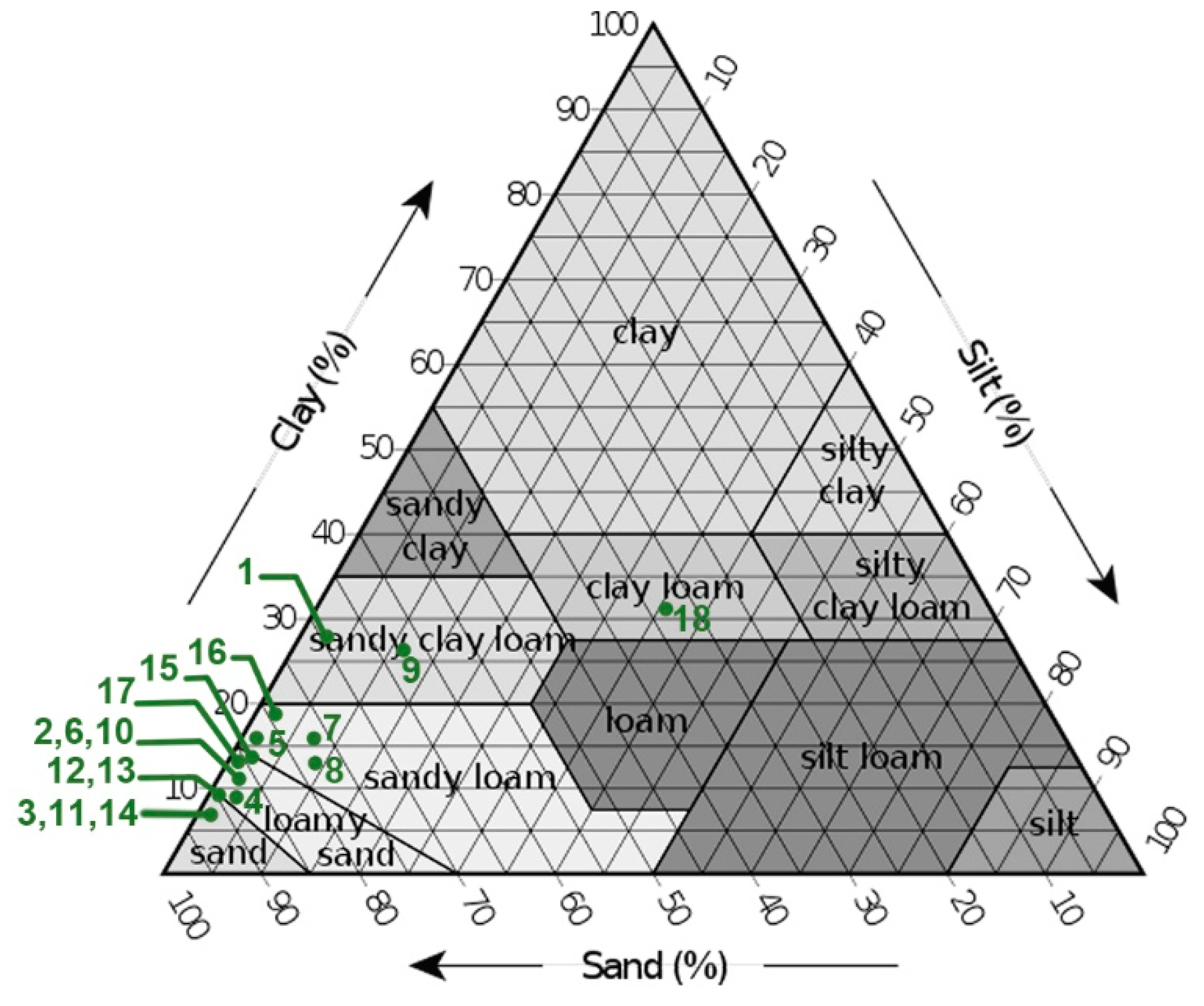
- QS2: Soil texture
- QS3: Depth of soil
- QD: Desertification sensitivity
- QS: Qualitative soil
- QW: Qualitative water
2.2.3. Scenario Design
- scenarios represent a process of change over some duration;
- scenarios describe situations, actions, and consequences which are contingently related;
- scenarios are understood to be predictive judgments which describe what could happen, not predictions which describe what will happen, or even what is likely to happen;
- scenarios organize information within explicitly defined frameworks” [35].
- Scenario 1: Evolution of current conditions.In this regard, 3 very important and effective projects have been selected: (i) Comprehensive planning (2013); (ii) Tourism route planning (2011); (iii) Afforestation (combat to desertification projects through biological stabilization by planting Haloxylon trees implemented in Aran-Bidgol county, last update 2018).In the following, the main idea of each project and its effects on landscape changes are examined.
- Scenario 2: Reconstruction of the past.This scenario is based on the hypothesis of the resettlement of rural areas by the preservation and restoration of existing cultural heritage, such as qanats and small settlements, together with technological innovation for water supply.
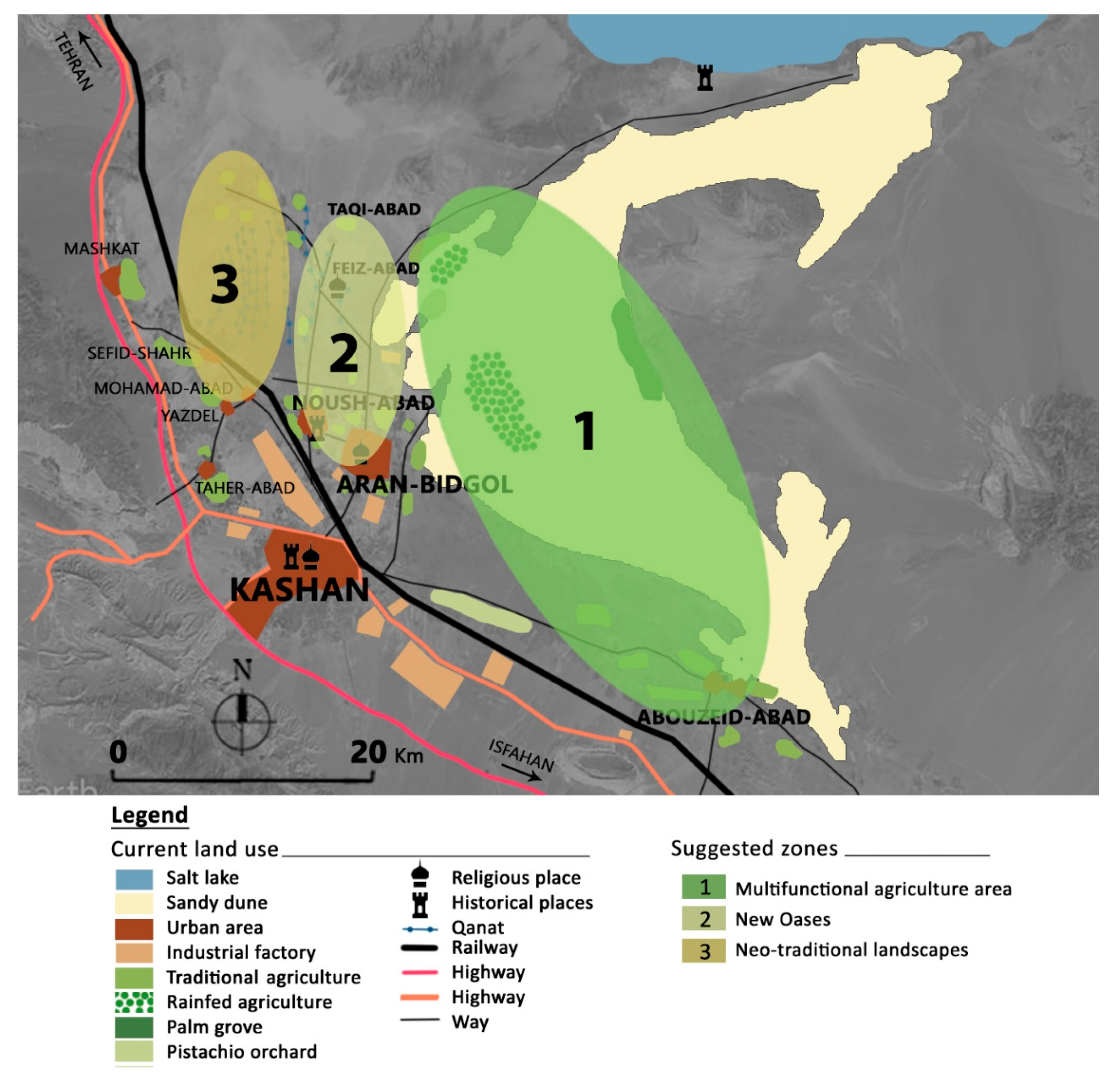
- Scenario 3: New-traditional spatial configuration.This scenario is based on a landscape architecture project that implies the reorganization of the rural and agricultural landscape in the desert margin as a barrier against desertification leading to a new oasification.
3. Results and Discussion
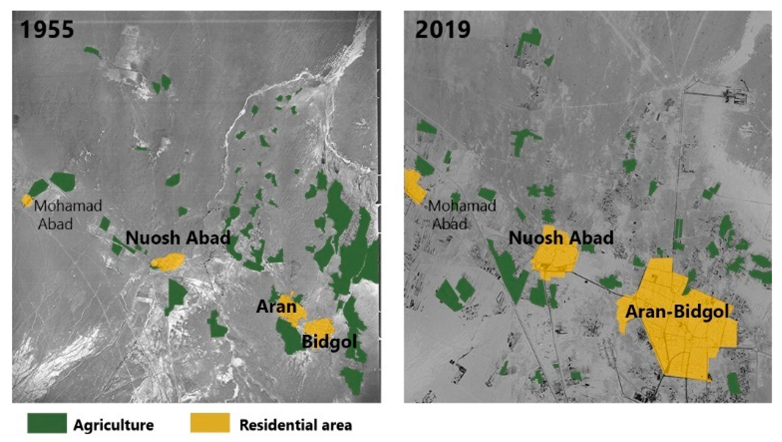
3.1. Landscape Analysis
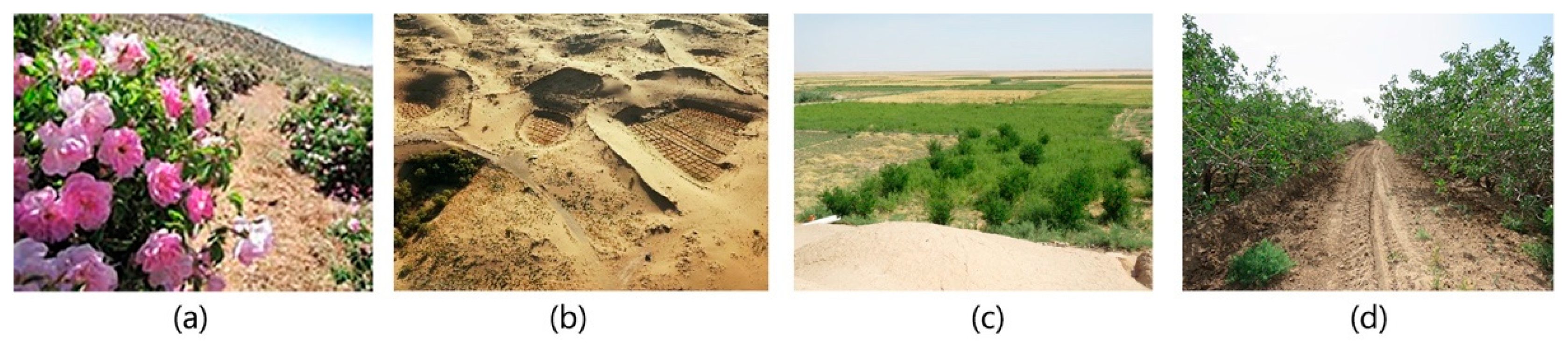
- Traditional or subsistence farming in the form of family farming, where the main crops are barley (Hordeum vulgare), wheat (Triticum spp), alfalfa (Medicago sativa), and melon (Cucumis melo);
- Semi-modern or commercial farming in the form of cooperative farming, where the main crop is pistachio (Pistacia vera).
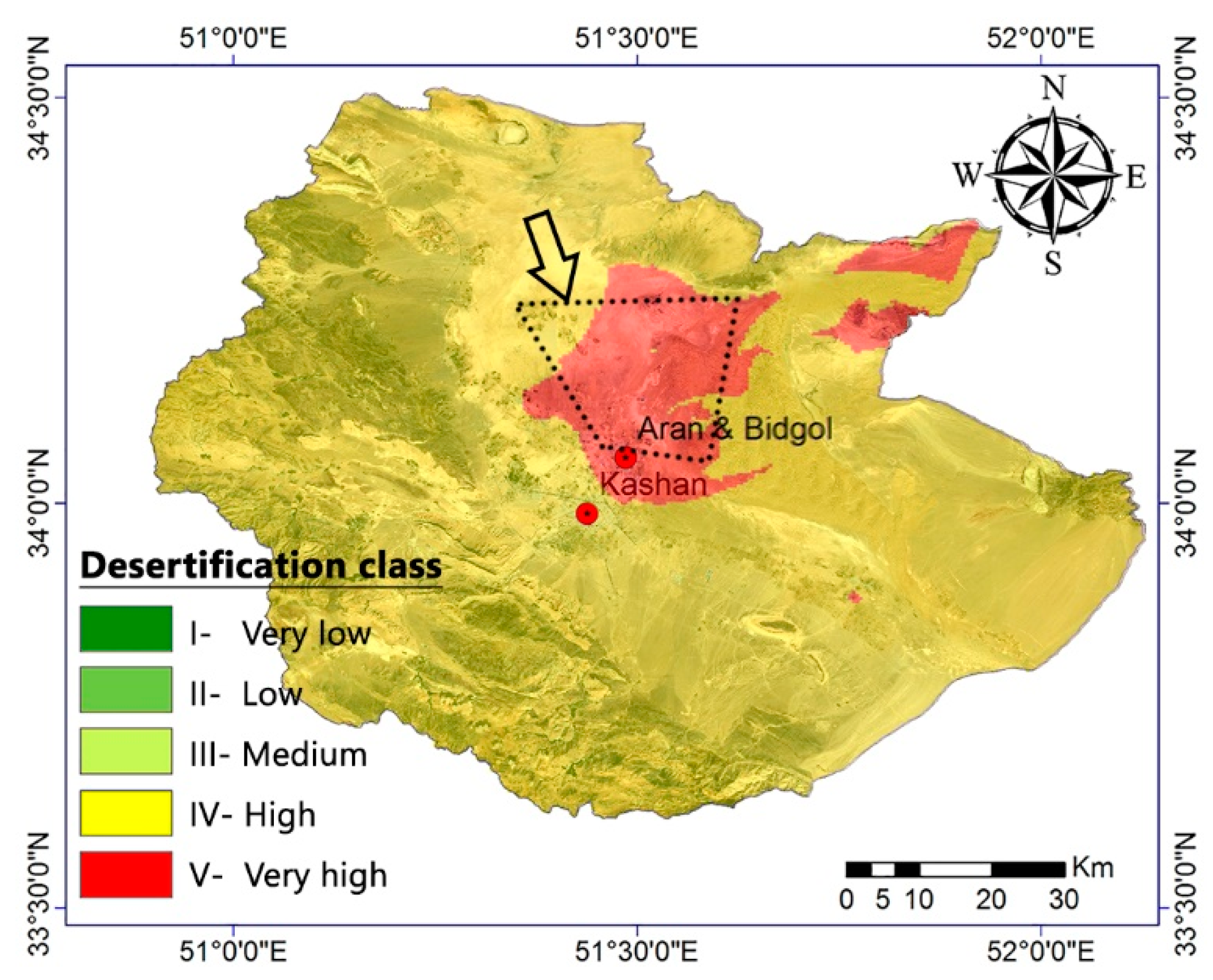
3.2. The Severity of Desertification in the Study Area
3.3. Probable Future of Landscape in Three Scenarios
3.3.1. Scenario 1: Evolution of Current Conditions
- (I)
- In “Comprehensive planning-2013”, the remote villages have been completely ignored. The distance from main urban centers and related services is reinforcing a migration process from small villages to cities (Table 4; Figure S3). In this way, a large part of the county will be abandoned, and the entire population of the county will be concentrated in a small area. The abandonment of land, as a global problem with environmental implications, increases the risk of land degradation and desertification [44].
- (II)
- “Tourism routes planning -2011” aims to increase revenue for the region’s indigenous people through tourism. Seven tourist routes, which often start from mountainous areas in Kashan county and end at Maranjab Caravanserai in Aran-Bidgol county, are designed (Figure S4). Despite its many advantages and strengths, this project also has its weaknesses. Many tourists must enter the area in autumn and spring, which will damage the environment and vegetation of the area. In addition, tourists’ favorite pastimes, such as skiing on the sand, safaris, and car racing on sand dunes, increase soil erosion. Another criticism of the project is its disregard for other cultural potentials as tourist attractions.
- (III)
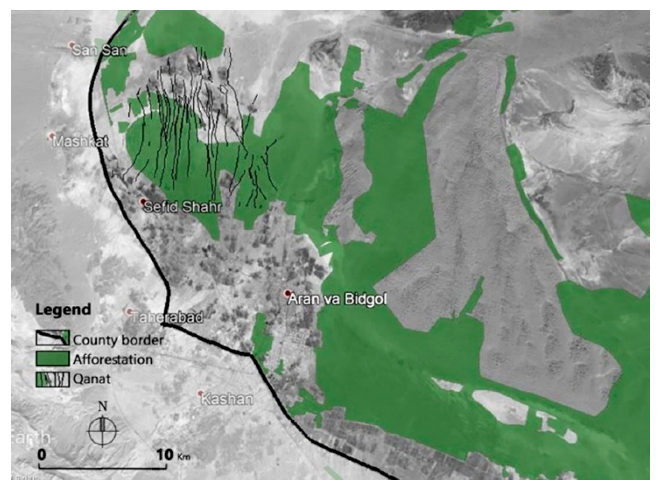
- Finally, we evaluated the “Afforestation plan”. According to UNCCD (United Nations Convention to Combat Desertification), “Afforestation is the planting of trees or forest cover on land which historically did not contain forests” [45]. In Iran, the project of biological stabilization of sand dunes began in 1963. For the first time, it was tested on the sand dunes near Abuzeid-Abad city, in Aran-Bidgol county, and it had great success [46]. The project, originally intended only for the establishment of sand dunes, has expanded over time as a green belt. The main aims are: soil stabilization, increasing shade and soil moisture, reducing soil erosion, windbreak function [47]. Today, this project is underway even near the qanats (Figure 16). Because of the deep and extensive “roots of trees that can intensify the tunnel crumbling of qanats” and cause irreparable damage to this valuable cultural heritage, “the qanat masters do not recommend planting the trees” [48].
3.3.2. Scenario 2: Reconstruction of the Past
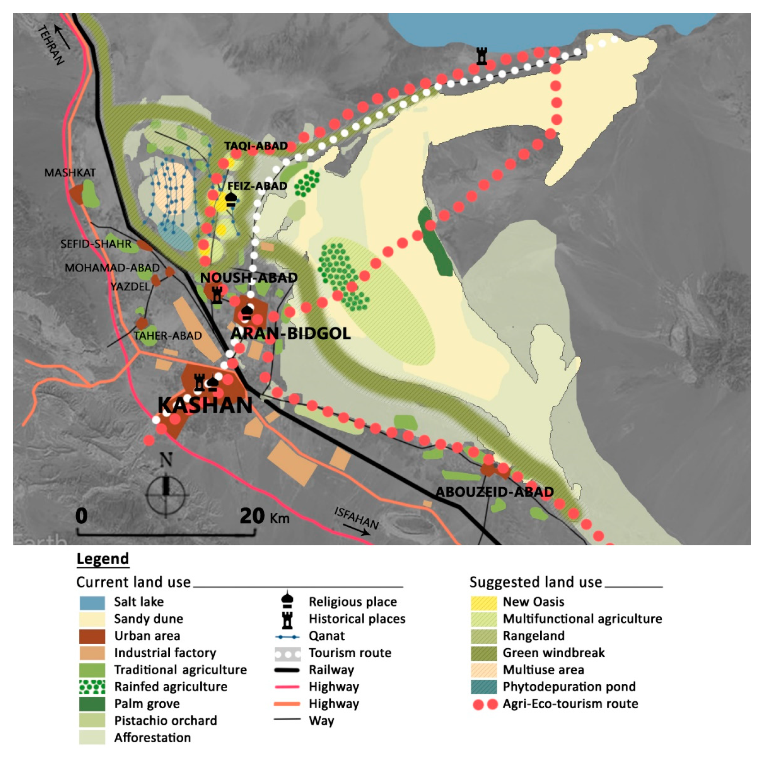
3.3.3. Scenario 3: New-Traditional Spatial Configuration
- 1-
- Traditional agricultural areas on the sand dunes, as a multifunctional agriculture space of high potential for agri-tourism;
- 2-
- The axis that connects urban areas to remote villages, as a suitable area to insert: (a) the new oases for a better distribution of the population, and (b) a green barrier in the form of a multifunctional productive landscape;
- 3-
- The cultural and historical areas composed of the abandoned villages and qanats, as a neo-traditional landscape divided into three parts: (a) phytodepuration ponds to recharge the aquifer (low-tech and low-cost); (b) the qanat area as a cultural heritage to be preserved and integrated with technological innovation (e.g., photovoltaic park); the replacement of abandoned villages and degraded agricultural land with land-uses less sensitive to water quality (e.g., cultivation of specific plants for foraging, grazing). The resulting landscape masterplan design is reported in Figure 18.
- Multifunctional agriculture;
- Productive green windbreaks instead of Haloxylon afforestation (afforestation limited only to places where a windbreak function is necessary);
- Eco-friendly new oases (water treatment and watershed management projects; research farms, eco-camping, solar farms);
- A regenerated economy (industries related to agriculture and animal husbandry, industries related to indigenous knowledge (e.g., in the study area, handmade carpets have a long history, so relevant industries such as dyeing and spinning are justified)).
4. Conclusions
Supplementary Materials
Author Contributions
Funding
Institutional Review Board Statement
Informed Consent Statement
Data Availability Statement
Acknowledgments
Conflicts of Interest
References
- Patel, K.; Gartaula, H.; Johnson, D.; Karthikeyan, M. The interplay between household food security and wellbeing among small-scale farmers in the context of rapid agrarian change in India. Agric. Food Secur. 2015, 4, 16. [Google Scholar] [CrossRef]
- Li, C.; Lei, J.; Zhao, Y.; Xu, X.; Li, S. Effect of saline water irrigation on soil development and plant growth in the Taklimakan Desert Highway shelterbelt. Soil Tillage Res. 2015, 146, 99–107. [Google Scholar] [CrossRef]
- Ghanbarpour, M.R.; Ahmadi, E.; Gholami, S. Evaluation of different traditional water management systems in semi-arid regions (case study from Iran). Options Méditerranéennes Série B Etudes Rech. 2007, 3, 133–139. [Google Scholar]
- Saboohi, R.; Barani, H.; Khodagholi, M.; Sarvestani, A.A.; Tahmasebi, A. Nomads’ indigenous knowledge and their adaptation to climate changes in Semirom City in Central Iran. Theor. Appl. Clim. 2018, 137, 1377–1384. [Google Scholar] [CrossRef]
- Verón, S.; Paruelo, J.; Oesterheld, M. Assessing desertification. J. Arid. Environ. 2006, 66, 751–763. [Google Scholar] [CrossRef]
- Yan, X.; Cai, Y.L. Multi-Scale Anthropogenic Driving Forces of Karst Rocky Desertification in Southwest China. Land Degrad. Dev. 2015, 26, 193–200. [Google Scholar] [CrossRef]
- Barrios, S.; Bertinelli, L.; Strobl, E. Climatic Change and Rural-Urban Migration: The Case of Sub-Saharan Africa. J. Urban Econ. 2006, 60, 357–371. [Google Scholar] [CrossRef]
- Madanipour, A. Urban planning and development in Tehran. Cities 2006, 23, 433–438. [Google Scholar]
- Mirzayi, J.; Peyvastegar, Y.; Kalantari, H. Presenting the Exploratory-Experimental Model of Factors Inhibiting the Realization of Urban Comprehensive Plans (Case Study: Shiraz Metropolis). Hum. Geogr. Res. 2020, 52, 1391–1408. [Google Scholar]
- Farhoodi, R.; Gharakhlou, N.M.; Ghadami, M.; Khah, M.P. A Critique of the Prevailing Comprehensive Urban Planning Paradigm in Iran: The Need for Strategic Planning. Plan. Theory 2009, 8, 335–361. [Google Scholar]
- Darkoh, M.B.K. The nature, causes and consequences of desertification in the drylands of Africa. Land Degrad. Dev. 1998, 9, 1–20. [Google Scholar] [CrossRef]
- Goffner, D.; Sinare, H.; Gordon, L.J. The Great Green Wall for the Sahara and the Sahel Initiative as an opportunity to enhance resilience in Sahelian landscapes and livelihoods. Reg. Environ. Chang. 2019, 19, 1417–1428. [Google Scholar] [CrossRef]
- Saley, I.A.; Salack, S.; Sanda, I.S.; Moussa, M.S.; Bonkaney, A.L.; Ly, M.; Fodé, M. The possible role of the Sahel Greenbelt on the occurrence of climate extremes over the West African Sahel. Atmos. Sci. Lett. 2019, 20, e927. [Google Scholar] [CrossRef]
- Cao, S. Why Large-Scale Afforestation Efforts in China Have Failed to Solve the Desertification Problem; ACS Publications: Washington, DC, USA, 2008. [Google Scholar]
- Medugu, N.I.; Majid, M.R.; Johar, F.; Choji, I. The role of afforestation programme in combating desertification in Nigeria. Int. J. Clim. Chang. Strat. Manag. 2010, 2, 35–47. [Google Scholar] [CrossRef]
- Beiser, V. China’s Green Great Wall is on the Front Line of Its Fight against Desertification, But Is It Sustainable? 2018. Available online: https://www.scmp.com/magazines/post-magazine/long-reads/article/2177586/chinas-green-great-wall-front-line-its-fight (accessed on 20 May 2020).
- Ceci, P.; Sanogo, S.; Ambrose, E.; Sacande, M.; Sanou, L.; Adda, M.; Ulian, T. SDG 15: TARGET 15.3 REVERSING LAND DEGRADATION AND DESERTIFICATION IN AFRICA’S DRYLANDS. BGjournal 2018, 15, 19–22. [Google Scholar]
- F.A.O. Great Green Wall. Available online: http://www.fao.org/in-action/action-against-desertification/overview/great-green-wall/en/ (accessed on 26 May 2020).
- Luengo, M. Looking ahead: The olive grove cultural landscape. In Proceedings of the ICOMOS 17th General Assembly, Paris, France, 27 November 2011; 2012; pp. 623–630. Available online: http://openarchive.icomos.org/id/eprint/1257/1/III-2-Article9_Luengo.pdf (accessed on 15 March 2019).
- Bonine, M.E. The morphogenesis of iranian cities∗. Ann. Assoc. Am. Geogr. 1979, 69, 208–224. [Google Scholar] [CrossRef]
- English, P.W. The origin and spread of qanats in the Old World. Proc. Am. Philos. Soc. 1968, 112, 170–181. [Google Scholar]
- English, P.W. Qanats and lifeworlds in Iranian plateau villages. Yale F ES Bull. 1998, 103, 187–205. [Google Scholar]
- De Cesaris, A.; Di Giorgio, G.; Ferretti, L.V. Attraverso l’Iran. Citta, Architetture, Paesaggi; no. 1; Manfredi edizioni: Macerata, Italy, 2017. [Google Scholar]
- Jafary, F.; Bradley, C. Groundwater irrigation management and the existing challenges from the farmers’ perspective in Central Iran. Land 2018, 7, 15. [Google Scholar]
- Johnston, R.J. The dictionary of human geography. In The Dictionary of Human Geography; Basil Blackwell: Oxford, UK, 1981; p. 718. [Google Scholar]
- Łach, J.; Szczepańska, B. Contemporary Directions of Transformations in the Settlement and the Landscape of Rural Areas in the Silesian Lowland. Quaest. Geogr. 2020, 39, 55–73. [Google Scholar] [CrossRef]
- Antrop, M. Why landscapes of the past are important for the future. Landsc. Urban Plan. 2005, 70, 21–34. [Google Scholar] [CrossRef]
- Naveh, Z. From biodiversity to ecodiversity—holistic conservation of the biological and cultural diversity of Mediterranean landscapes. In Landscape Disturbance and Biodiversity in Mediterranean-Type Ecosystems; Springer: New York, NY, USA, 1998; pp. 23–53. [Google Scholar]
- Biasi, R.; Brunori, E.; Smiraglia, D.; Salvati, L. Linking traditional tree-crop landscapes and agro-biodiversity in central Italy using a database of typical and traditional products: A multiple risk assessment through a data mining analysis. Biodivers. Conserv. 2015, 24, 3009–3031. [Google Scholar]
- Bestelmeyer, B.T.; Okin, G.S.; Duniway, M.C.; Archer, S.R.; Sayre, N.F.; Williamson, J.C.; Herrick, J.E. Desertification, land use, and the transformation of global drylands. Front. Ecol. Environ. 2015, 13, 28–36. [Google Scholar] [CrossRef]
- Thornes, J.; Brandt, C.J. Mediterranean Desertification and Land Use; Wiley Chichester: Chichester, UK, 1996. [Google Scholar]
- Ekhtesasi, M.R. How to Classify Desertification in Iran; Research Institute of Forests and Rangelands: Tehran, Iran, 1996. [Google Scholar]
- Abad, J.R.S.; Nohegar, A.; Zehtabian, G.; Khosravi, H.; Gholami, H. Study of desertification status based on a sub-IMDPA model for a case study in Yazd-Ardakan plain, Iran. Int. J. For. Soil Eros. 2016, 6, 73–81. [Google Scholar]
- UNRCS. Soil survey division staff (1993) soil survey manual. Soil conservation service. US Dep. Agric. Handb. 1993, 18, 315. [Google Scholar]
- Shearer, A.W. Approaching Scenario-Based Studies: Three Perceptions about the Future and Considerations for Landscape Planning. Environ. Plan. B Plan. Des. 2005, 32, 67–87. [Google Scholar]
- Shirehpaz, A. Aran and Bidgol: Jewel of Central Desert of Iran; Maranjab: AranBidgol, Iran, 2018. [Google Scholar]
- Majd, M.G. Land Reform Policies in Iran. Am. J. Agric. Econ. 1987, 69, 843–848. [Google Scholar] [CrossRef]
- Gleeson, T.; Vandersteen, J.; Sophocleous, M.A.; Taniguchi, M.; Alley, W.M.; Allen, D.M.; Zhou, Y. Groundwater sustainability strategies. Nat. Geosci. 2010, 3, 378–379. [Google Scholar] [CrossRef]
- Kardavani, P. The Problems of Waters in Iran, 10th ed.; University of Tehran Press: Tehran, Iran, 2011. [Google Scholar]
- Satterthwaite, D.; McGranahan, G.; Tacoli, C. Urbanization and its implications for food and farming. Philos. Trans. R. Soc. B Biol. Sci. 2010, 365, 2809–2820. [Google Scholar] [CrossRef]
- Plieninger, T.; Höchtl, F.; Spek, T. Traditional land-use and nature conservation in European rural landscapes. Environ. Sci. Policy 2006, 9, 317–321. [Google Scholar]
- Altieri, M.A. Linking Ecologists and Traditional Farmers in the Search for Sustainable Agriculture. Front. Ecol. Environ. 2004, 2, 35–42. [Google Scholar] [CrossRef]
- Aran Bidgol. Available online: https://fa.wikipedia.org/wiki/شهرستان_آران_و_بیدگل (accessed on 18 September 2019).
- Kosmas, C.; Kairis, O.; Karavitis, C.; Acikalin, S.; Alcala, M.; Alfama, P.; Atlhopheng, J.; Barrera, J.; Belgacem, A.; Solé-Benet, A.; et al. An exploratory analysis of land abandonment drivers in areas prone to desertification. Catena 2015, 128, 252–261. [Google Scholar] [CrossRef]
- UNCCD. Sustainable Land Management Contribution to Successful Land-based Climate Change Adaptation and Mitigation; UNCCD: Bonn, Germany, 2017. [Google Scholar]
- Kardavani, P. The Great Central Kawir of Iran, 2nd ed.; University of Tehran Press: Tehran, Iran, 2008. [Google Scholar]
- Jin, Z.-Z. Soil microbial variation and relationship with soil environmental factors in the desert hinterland greenbelt. Chin. J. Eco-Agriculture 2008, 16, 1358–1364. [Google Scholar] [CrossRef]
- Yazdi, A.A.S.; Khaneiki, M.L. Qanat Maintenance and Preservation. In Qanat Knowledge; Springer: Dordrecht, The Netherlands, 2017; pp. 117–143. [Google Scholar]
- Hamdy, A. Irrigation with treated municipal wastewater. In Prospett. e Propos. Mediterr. di Econ. Agric. e Ambient; Bari, Italy, 1992; 1/92, 50-54; Available online: http://www.iamb.it/share/img_new_medit_articoli/549_50hamdy.pdf (accessed on 25 October 2019).
- García-Martín, M.; Bieling, C.; Hart, A.; Plieninger, T. Integrated landscape initiatives in Europe: Multi-sector collaboration in multi-functional landscapes. Land Use Policy 2016, 58, 43–53. [Google Scholar]
- Mann, C.; Garcia-Martin, M.; Raymond, C.M.; Shaw, B.J.; Plieninger, T. The potential for integrated landscape management to fulfil Europe’s commitments to the Sustainable Development Goals. Landsc. Urban Plan. 2018, 177, 75–82. [Google Scholar] [CrossRef]
- Xue, J.; Gui, D.; Lei, J.; Sun, H.; Zeng, F.; Mao, D.; Jin, Q.; Liu, Y. Oasification: An unable evasive process in fighting against desertification for the sustainable development of arid and semiarid regions of China. Catena 2019, 179, 197–209. [Google Scholar] [CrossRef]
- Makhzoumi, J.; Talhouk, S.; Zurayk, R.; Sadek, R. Landscape approach to bio-cultural diversity conservation in rural Lebanon. In Perspectives on Nature Conservation-Patterns, Pressures and Prospects; Intech: Rijeka, Croatia, 2012; pp. 179–198. [Google Scholar]
- Paracchini, M.L.; Zingari, P.C.; Blasi, C. Reconnecting Natural and Cultural Capital; Publication Office of the European Union: Luxembourg, 2018; p. 253. [Google Scholar]
- Sarlak, M. Agricultural Landscape of the Sandy Desert in Iran. Ph.D. Thesis, Sapienza University of Rome, Rome, Italy, 2020. [Google Scholar]


| Document/Data | Year | Official Sources |
|---|---|---|
| Topography map | 2017 | Iran National Cartographic Center |
| Aerial photo | 1955 | Iran’s National Geographical Organization |
| Agricultural zones map | 1974 | Iran’s National Geographical Organization |
| Prescription plains for drilling new wells | 2017 | Regional Water company of Isfahan |
| Demographic statistics | 2006–2016 | Statistical Center of Iran (available in https://www.amar.org.ir/, Accessed on 20 July 2018) |
| Desertification Classes | <1 | 1–1.5 | 1.6–2.5 | 2.6–3.5 | 3.6–4 |
|---|---|---|---|---|---|
| Very Low | Low | Medium | High | Very High | |
| EC (μs/cm) | <250 | 250–750 | 2250–750 | 5000–2250 | ≥5000 |
| SAR (meq/L) | <10 | 10–18 | 26–18 | 32–26 | ≥32 |
| Groundwater Decline (cm/year) | <10 | 10–20 | 30–20 | 50–30 | ≥50 |
| Desertification Classes | < 1 | 1–1.5 | 1.6–2.5 | 2.6–3.5 | 3.6–4 |
|---|---|---|---|---|---|
| Very Low | Low | Medium | High | Very High | |
| EC (ds/m) | <2 | 2–4 | 4–8 | 8–16 | ≥16 |
| Depth (cm) | >110 | 80–110 | 50–80 | 20–50 | <20 |
| Soil texture | Clay | Clay loam | Loam | Sandy loam | Sandy |
| Unit | 2006 | 2011 | 2016 | |
|---|---|---|---|---|
| Village with inhabitants | number | 49 | 45 | 41 |
| Village without inhabitants | number | 61 | 65 | 69 |
| Urban population | person | 76,438 | 82,332 | 89,022 |
| Rural population | person | 13,523 | 15,077 | 14,495 |
| Total population | person | 89,961 | 97,409 | 103,517 |
| 2001 | 2006 | 2011 | 2016 | |
|---|---|---|---|---|
| Farming areas | 10,227 | 11,004 | 10,397 | 8181 |
| Orchards | 1180 | 1561 | 2305 | 2256 |
| The total area of irrigated agriculture | 11,407 | 12,565 | 12,702 | 10,437 |
| Category | Main Crop | Area (ha) | |||
|---|---|---|---|---|---|
| 2001 | 2006 | 2011 | 2016 | ||
| Cereals | Barley | 4000 | 4235 | 4700 | 3600 |
| Wheat | 1900 | 1525 | 1400 | 800 | |
| Plants used in industry | Cotton | 1148 | 1018 | 850 | 500 |
| Forage | Alfalfa | 700 | 350 | 600 | 919 |
| Forage corn | 342 | 541 | 540 | 300 | |
| Kitchen garden | Cantaloupe | 680 | 1169 | 1055 | 668 |
| Melon | 385 | 347 | 350 | 177 | |
| Orchards | Pistachio | 1100 | 1198 | 2065 | 1581 |
| Olives | 30 | 123 | - | - | |
| Pomegranate | - | 97 | 235 | 195 | |
| Name | Establish Date | Product | Area (ha) |
|---|---|---|---|
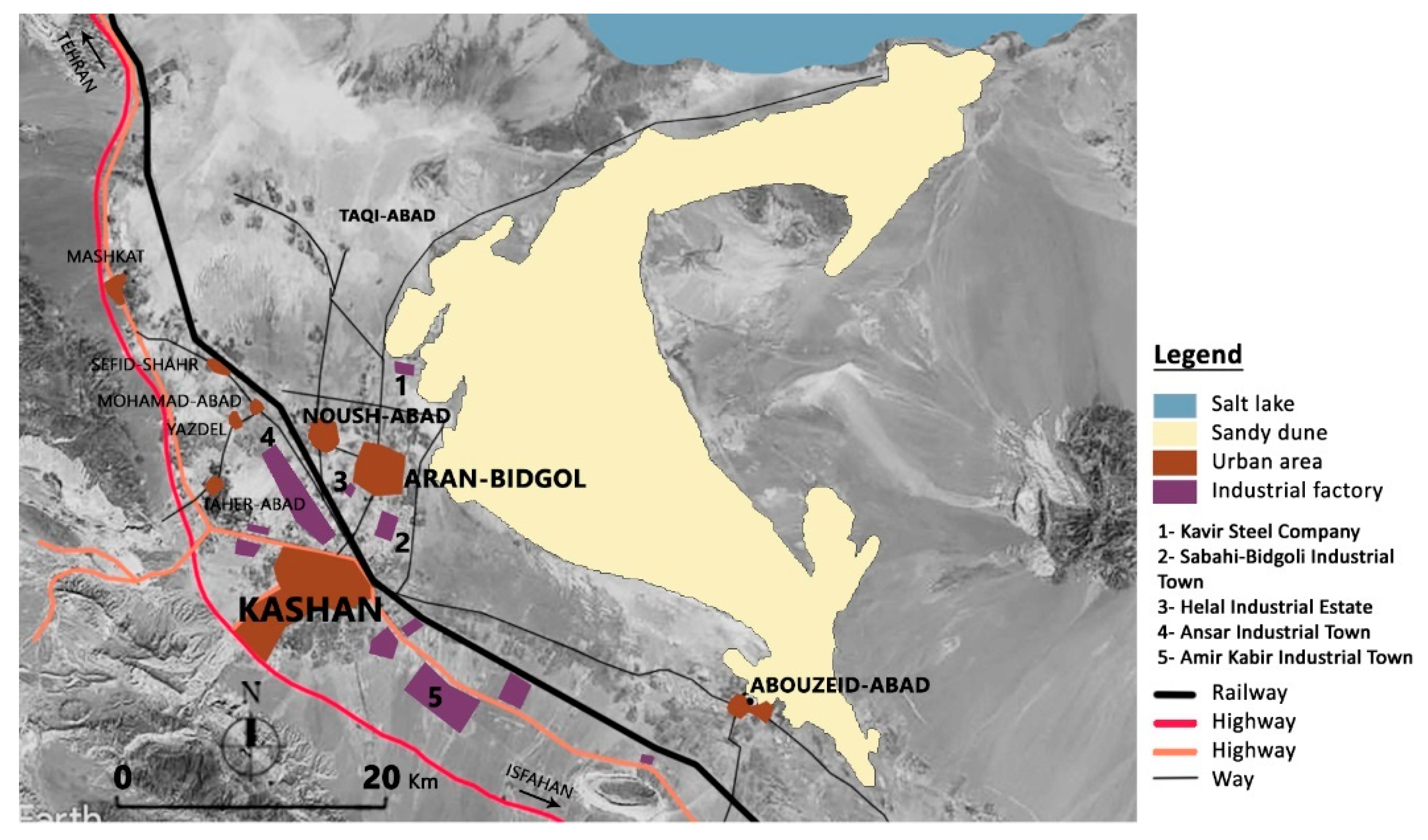
| Kavir Steel Company | 2000 | Rebar, wire rod | 45 |
| Sabahi-Bidgoli Industrial Town | 1990 | Machine-made carpets, chemicals and hygienic material production, home dishes and appliances manufacturing units, and motor pumps making units | 400 |
| Helal Industrial Estate | 2003 | Machine-made carpets, textile, knitting industries | 57 |
Publisher’s Note: MDPI stays neutral with regard to jurisdictional claims in published maps and institutional affiliations. |
© 2021 by the authors. Licensee MDPI, Basel, Switzerland. This article is an open access article distributed under the terms and conditions of the Creative Commons Attribution (CC BY) license (http://creativecommons.org/licenses/by/4.0/).
Share and Cite
Sarlak, M.; Ferretti, L.V.; Biasi, R. The Productive Landscape in the Desert Margin for the Sustainable Development of Rural Settlements: An Innovative Greenbelt for Maranjab Desert in Iran. Sustainability 2021, 13, 2077. https://doi.org/10.3390/su13042077
Sarlak M, Ferretti LV, Biasi R. The Productive Landscape in the Desert Margin for the Sustainable Development of Rural Settlements: An Innovative Greenbelt for Maranjab Desert in Iran. Sustainability. 2021; 13(4):2077. https://doi.org/10.3390/su13042077
Chicago/Turabian StyleSarlak, Mahnaz, Laura Valeria Ferretti, and Rita Biasi. 2021. "The Productive Landscape in the Desert Margin for the Sustainable Development of Rural Settlements: An Innovative Greenbelt for Maranjab Desert in Iran" Sustainability 13, no. 4: 2077. https://doi.org/10.3390/su13042077
APA StyleSarlak, M., Ferretti, L. V., & Biasi, R. (2021). The Productive Landscape in the Desert Margin for the Sustainable Development of Rural Settlements: An Innovative Greenbelt for Maranjab Desert in Iran. Sustainability, 13(4), 2077. https://doi.org/10.3390/su13042077