Article

Transformation Directions of Brownfields: The Case of the Górnośląsko-Zagłębiowska Metropolis

1
Institute of Social and Economic Geography and Spatial Management, Faculty of Natural Sciences, University of Silesia in Katowice, ul. Będzińska 60, 41-200 Sosnowiec, Poland
2
Faculty of Finance and Management, WSB University in Wrocław, ul. 53-609 Wrocław, Poland
*
Author to whom correspondence should be addressed.
Sustainability 2021, 13(4), 2075; https://doi.org/10.3390/su13042075
Submission received: 2 December 2020 / Revised: 27 January 2021 / Accepted: 9 February 2021 / Published: 15 February 2021
(This article belongs to the Special Issue Brownfields in Sustainable Urban and Rural System)

Abstract

:
Brownfields are remnants of the functional and spatial transformations of urban areas in Poland. They are particularly abundant in old industrial districts, based on coal mining and metallurgy. The aim of this study is to identify the transformation directions and functional changes of brownfields in the former Upper Silesian Industrial Region in southern Poland, which has evolved into the Górnośląsko-Zagłębiowska Metropolis (GZM) through the process of socio-economic transformation. The study makes use of the χ2 test of independence and Cramer’s V as a post-test, and the method of in-depth interviews. The results indicate that the most popular new functions of post-industrial sites are production and services. When we consider large brownfields such as, in particular, disused mine dumps, dumping sites, settling ponds and workings, the most popular new form of land use is green spaces. Moreover, the study shows that the size of brownfields impacts their new forms of land use.

1. Introduction

Brownfields emerging within Polish urban areas are a consequence of functional transformations and a result of the natural spatial implications of the economic cycle. They are particularly common in traditional industrial regions, where heavy industry used to dominate. Old factories and other facilities were abandoned when the demand for their products fell dramatically, or when new technologies were introduced to replace old ones. The social and economic transformation, which amounted to the dismantling of the whole state-controlled economy (and included, in particular, limiting the state monopoly and stopping exports to the former Soviet Union), resulted in deindustrialization implemented through both a lack of investment and the closing down of companies. The role of industry as the main driver of the Polish economy has decreased considerably. This is observable particularly in the cities and towns that now belong to the Górnośląsko-Zagłębiowska Metropolis, i.e., a region that thrived on coal and steel. However, the transformation did not only close down companies, as new ones were launched at the same time, which is a very positive phenomenon involving the creation of new jobs, boosting the income of local enterprises, and increasing taxes paid at the local level. This resulted in a considerably improved image of post-industrial towns and cities, and in the creation of a new spatial order, which, in turn, attracts new investments. Similar phenomena of varying intensity have been observable, in various periods, in the whole of western Europe. The regeneration of brownfields, which are often heavily polluted, is a key issue for the whole European Union, due to the widely recognized need for land, soil and water conservation. The above considerations are reflected in EU regulations, and consequently, they are applicable to all Member States [1,2,3].
According to Ref. [4], about 60% of urban municipalities in Poland possess disused brownfields and industrial sites. Post-industrial degradation is estimated to affect about 8000 km2 of land, including about 1400 km2 accounted for by heavy and very heavy degradation. Disused brownfields have become a big problem, particularly for smaller cities and towns, with lower potential and less finance. Consequently, they have suffered from crises related to deindustrialization to a greater degree than big cities and conurbations. Depopulation has been the most acute problem, and in order to stop it, the fast regeneration of degraded land and its transformation is essential. Białecka and Biały [5] indicate that the transformation goals for such areas should be harmonized with the overall policy of sustainable development in the region. These goals fall into three categories: environmental, economic and social. The environmental goals are related to the improvement of environmental conditions and to the protection and shaping of post-industrial landscapes; they include, for example, the establishment of organic farms, nature reserves, parks and the like. They are often combined with the protection of cultural heritage, especially where we deal with the conservation of post-industrial landscapes. The economic goals are the main drivers of the adaptation of brownfields and disused industrial sites. The directions are very diverse in this case, and include, for example, the building of facilities for the needs of production and services. The social goals include activities related to culture, science and education, as well as the development of land for housing.
“Brownfields” are defined in Poland as “degraded, disused or only partly used land previously allocated for economic activity that has been discontinued” [6]. Domański [7] describes them as areas that stopped functioning as industrial production sites or stopped performing auxiliary functions for production within industrial sites, including areas where investments of an industrial nature have been left unfinished.
The aim of the article is to identify the transformation directions and new functions of brownfields in the Górnośląsko-Zagłębiowska Metropolis (GZM).
The article consists of two parts. The first part presents research and concepts related to the transformation and regeneration of brownfields, as well as studies on the topic published in Poland and abroad to-date. The second part describes the transformation directions of brownfields and disused industrial sites on the basis of the authors’ own quantitative and qualitative research.

2. Literature Review

Industrial areas have been given a lot of attention by both Polish and foreign authors. Old industrial areas in Europe have played a crucial role in the economic development of individual countries, but they also contribute to the cultural heritage of the whole continent. In the past, these areas typically benefited from their convenient location in the context of a specific economic era. North Rhine-Westphalia in Germany, Yorkshire in England, Nord-Pas-de-Calais in France and Upper Silesia in southern Poland are the cradles of the Industrial Revolution. In all of them, heavy industry, and coal mining in particular, played an important role in shaping the post-industrial heritage, and left lasting remnants in the landscape. The resulting spatial structure and brownfields are still visible in today’s urban morphology, in the form of regenerated and adapted post-industrial sites.
The Rhur was the largest industrial district in Europe, with over a dozen big cities, such as Essen, Dortmund and Düsseldorf. This industrial district emerged on the basis of the local deposits of hard coal, brown coal, lead, zinc and rock salt [8]. The region has undergone structural transformations based on its post-industrial heritage [9,10,11], and regeneration has given new functions to disused industrial sites [12,13,14]. The Ruhr has largely been shaped by the IBA Emscher Park project, aiming to preserve the cultural heritage of this industrial region. Many scholars have discussed this project; among others, Ref. [15] presents a critical appraisal against the background of sustainable development, including reflections for the future. Seltmann [16] discusses the impact of IBA Emscher Park on the relevant political and administrative framework. Selected examples of regeneration activities undertaken in the Ruhr are also described by Ref. [17].
Another example of an old industrial district is Yorkshire, located in northern England, which possesses deposits of hard coal as well as iron, zinc and lead ores. At present, the traditional industrial branches have lost their former significance, and have been replaced with the production of vehicles, the electronics industry and precision engineering. Kirk, Jefferys and Wall [18] described the changing character of former coalfields in South Yorkshire. Faull [19] noted that coal was a crucial fuel contributing to the development of industry in England from 1700, and the impact of coal mining is still visible in contemporary English landscapes. Beatty, Fothergill and Powell [20] pointed out that almost the entire British coal industry has been closed down since the early 1980s.
Another similar industrial district, located in northern France, is the Nord-Pas-de-Calais Mining Basin, with its capital in Lille. It emerged thanks to hard coal deposits and became a center of carbochemistry, as well as the steel and textile industry. Its restructuration resulted in the growing roles of the production of vehicles, the chemical industry, the electronics industry, the pharmaceutical industry, petrochemistry, printing, and the food industry. This region suffered heavily from the economic and social crisis after World War II, resulting from the decline of its main activity, i.e., coal mining [21]. Due to the restructuration and transformation of its mining sector, Nord-Pas-de-Calais requires consulting services related to environmental protection [22,23].
An analysis of connections among these three districts is presented by Ref. [24], concerning European deindustrialization at the end of the 20th century. Conzelmann [25], in turn, explores network-building and the EU’s regional policy. He emphasizes the significance of the “partnership rule” implemented in the European Regional Development Funds (ERDF) and other structural funds since 1988. This rule aims at granting subnational governmental institutions, such as regions and municipalities, as well as other social actors, an influence over the creation and implementation of regional policy programs that are co-financed by the EU’s structural funds.
When we look at the issues related to brownfields in a wider context, three research strands are clearly distinguishable. Industry exerts a lasting and significant effect on the spatial and functional urban structures. One important issue is the new cityscapes emerging on the basis of brownfields, and the reclamation of brownfields. Loures and Panagopoulos [26,27] indicated that the decline of certain industry sectors in recent decades, and the degraded land they have left behind, strongly influence the environment, economy, and culture, including also the communities of which they constitute inherent parts. Industrial landscapes of the 20th century are becoming outdated. Gospodini, A. [28] focused on landscape transformations in post-industrial cities, discussing and classifying post-industrial cityscapes on the basis of land use patterns, urban morphology and density. She argued that localization trends in post-industrial economic activity and the development of new city management strategies influence the cityscapes of post-modern urban areas. Kennedy [29] presented a comprehensive case study of the regeneration of urban areas carried out in Birmingham. He noted that landscapes characteristic of cities and their environs feature a wide variety of old and new forms, creating sharp contrasts between industrial and post-industrial spaces. On the one hand, we see derelict buildings, and on the other, spectacular flagship projects, Victorian housing and multicultural lifestyles.
Another important issue is the new investments located in brownfields. Adams and Watkins [30] endeavoured to answer the question of why housing needs to develop on the outskirts of cities when city centers abound in disused brownfields. Hall [31], in turn, reflected on fashioning post-industrial cities, and the problem of adjusting the urban and transportation structures that emerged in the radically different world of the 1960s to today’s needs. Researchers also devote their attention to post-mining landscapes as a special type of urban cultural landscapes [32]. In the process of shaping the landscape’s physiognomy, there is a need to preserve valuable facilities and their surroundings within the so-called wider landscape context. This is particularly important in central and eastern Europe, where industrialization was haphazard. Consequently, policies and strategies of state authorities, local governments and private investors play a crucial role in the transformation of brownfields. These may take various directions, e.g., transforming brownfields through international events [33], cultural policy [34] (which was employed, inter alia, in Barcelona), preserving the highest standards of urban planning [35], or cultural clusters, as, for example in the Netherlands [36]. Management strategies are related to the policy of sustainable development and the regeneration of urban areas. Couch and Dennemann [37] argued that in spite of the emergence of this process and the concept of sustainable development as parallel elements in British urban policy, the coordination between them has been inadequate, and there is a stronger emphasis on the regeneration of urban areas, and particularly its economic aspects, than on sustainable development. The American model of brownfield regeneration [38] involves the analysis of the structural policies of the US government regarding the old industrial areas at the turn of the 21st century, the essence of which is to define the main policy stages and the roles authorities at various levels are supposed to play in the regeneration process. A somewhat different approach to brownfields is presented by Ref. [39]. This piece analyzes the role of business improvement districts (BIDs) in the central business districts of main American cities, whose aims included shaping post-industrial space. An interesting perspective on the regeneration and adaptation of brownfields is offered by Ref. [40], highlighting the need to create an effective system for managing industrial sites in the Russian Federation through the creation of industrial parks. The restructuring of old industrial areas attracts a lot of attention in the research on regional development, both in highly industrialized economies and in emerging markets [41].
We may also distinguish a few research strands in Polish studies devoted to regeneration. The first one is related to cross-sectional research.
The initial experiences of the process of urban regeneration in Poland, including planning and implementation, are gathered in the works of Refs. [42,43]. Additionally, Refs. [44,45] write about the beginnings of spatial planning, and a diagnosis thereof is presented by Ref. [46]. The works of Ref. [47] are particularly interesting as an attempt at a synthesis of the issues related to the transformation of brownfields, including spatial planning, urban development, as well as many other fields. Kaczmarek [48,49,50] noted that the regeneration of urban areas in various parts of Europe has been taking place for many decades. In western Europe, such regeneration is systematically evaluated by the stakeholders, using multiple methods and taking into consideration a wide range of aspects. Kaczmarek also described the regeneration of brownfields in Łódź, and addressed the new dimension of urban development that results from regeneration.
The second research strand relates to the morphological transformations and urban renewal resulting from regeneration. Valuable studies on the morphological transformations of brownfields in Łódź are offered by Refs. [51,52]. In a similar vein, Ref. [53] presents the regeneration of the town Prudnik against the backdrop of the principles of sustainable development. There is also research on urban renewal through regeneration, as a complex process stimulating the competitiveness of a city [54]. The authors of Ref. [55] described the methods used to renew cities through regeneration, rehabilitation and restructuration. Szajnowska-Wysocka and Sobala [56] discussed the first examples of regeneration strategies for post-mining land in Katowice and Mysłowice, according to various regeneration projects at various stages of implementation. They presented, among other things, the post-industrial transformations of the coalmine “Kleofas”, which, thanks to its new function, has regained its usefulness for the inhabitants of the city, the conurbation and the region. Sitek and Szajnowska-Wysocka [57] described the impact of the regeneration process on shaping cityscapes. The authors analyzed cities that have large shares of brownfields. Although the cities possess a common history, regeneration has diverse effects on their landscapes, which is presented in the form of models. The study emphasizes the key role of an appropriate diagnosis in planning regeneration activities, whose aim is to ensure that the undertaken interventions are adequate. Krzysztofik, Kantor-Pietraga and Kłosowski [58] endeavoured to present the issue of regeneration on the basis of the examples of two small towns, Lędziny and Radzionków, located in southern Poland, in the Katowice conurbation. While both towns have very similar coal-mining roots, at present, they represent two radically different paths of economic development. Both the towns are developing relatively well; however, there exist certain risks to their development: social, functional, environmental, and even political ones. The selected examples show that a small post-mining town does not have to be “a place with no meaning”.
By analogy to foreign research, the strand focusing on the process of urban sustainable development management is also present in Poland, for instance in the works of Refs. [59,60]. These show natural regeneration as one of the instruments of urban management, which is particularly important for the reurbanization stage. This is illustrated using the example of Łódź. The authors describe its spatial development and its relations to the condition of the natural environment, and go on to present the regeneration initiatives undertaken so far, which are assessed taking into consideration their significance for the protection of natural elements within urban spaces. A wider perspective is presented by Refs. [61,62], focusing on regeneration strategies in inner-city space, strategic challenges for cities and local marketing. Polish researchers have also described some examples of urban transformation in the UK [63], in France [64], and in Germany [65,66].
Another strand encompasses theoretical approaches and models. Janas, Jarczewski and Wańkowicz [67] presented regeneration models at the country and regional level. They described the rules and mechanisms governing regeneration as well as the relevant structure, relations, processes and decision-taking. They discussed in detail the planning stage of a regeneration program, and defined the aims and priorities of regeneration. They also pointed out the need to integrate regeneration programs with other strategic programs and with planning documents. Rydzik [68] focused on access to financing for regeneration measures within regional development programs. He highlighted the importance of gauging and managing the value of areas undergoing regeneration, which consists of their unique features contributing to the originality of the local structure of inhabitants and users. He discussed the competences and the complementarity of institutions that participate in regeneration programs, at the same time assessing their adjustment to solving specific problems related to preparing and implementing local regeneration programs. Runge [69] outlined the present state of knowledge on functional and spatial transformations of complex settlement systems, particularly ones within traditional social and economic regions. He also suggested several models (circular models of economic transformations and urbanization). His point of departure is an endeavour to create a model of the origin and evolution of the economic base as a key element of other transformations in the socio-economic space. The article in Ref. [70] is another important theoretical contribution. The authors suggested an approach in which the basic category is a proposal of a typology of areas with degraded functions, which, in turn, relates to research on human geography. In their methodological proposal, the authors took into consideration variables such as the diversity of land use, time, economic functions, and the scope of geographic research. The final effect is an endeavour to dynamically present the evolution in land use, including, in particular, wasteland.
Since the 1990s, following the results of the political and economic transformation, studies on brownfield transformations and regeneration have gained considerable impetus in Poland. This may be attributed to the activation of free market mechanisms that influence the variation in land prices in urban areas. Brownfields localized within inner-city spaces have played a key role in the transformation of Polish urban space. This has attracted the attention of numerous scholars, including the author of Ref. [71]. Scholars point out that Polish cities need regeneration as a means to preserve their material and cultural heritage [72]. There are also some case studies focusing on regeneration processes in a specific city (Mysłowice [73] and Bytom [57]). Wider reflections on an international scale concerning the protection of cityscapes, the regeneration of urban space and the relevant socio-economic mechanisms are offered by Ref. [74].
Another research strand deals with directions taken by the transformation of brownfields. Domański [75] raised a crucial point: it is the durability of the land management that differentiates various forms of post-industrial transformation. Next to long-term transformations, which include the creation of new factories, big shopping centers, office buildings, etc., there is a very wide range of relatively short-term, impermanent options, such as leases for the needs of small trade and services, for storage, etc. The durability of land management is closely connected to the size of the investment and the ownership structure. It is higher when big companies buy land or obtain it in perpetual usufruct to carry out economic activities on a large scale than when small companies with little capital lease land, sometimes even aiming to sublet it.
Kobylańska and Gawor [76] distinguished three main models of land transformation, taking into account the character of regeneration and the scope of adaptation:
-
the first model consists of adapting for tourism these facilities that are valuable relics, with the preservation of their original function;
-
the second model consists of the adaptation of brownfields for new functions, industrial or industrial combined with others, e.g., educational, recreational, etc. The connection with the original industrial tissue may be big, medium or small;
-
the third model consists of the removal of post-industrial heritage and the adapting of brownfields for completely new functions, without a connection with the original industrial tissue.
Ostręga and Uberman [77] showed eight general transformation directions for post-industrial sites (Table 1). These range from economic to natural paths, the latter aiming at improving the natural environment. There is also an intermediate option that amounts to transformation into recreational space or water bodies, which is welcomed by local populations.
According to Ref. [4], transformation directions for brownfields and post-industrial sites fall into three main currents:
-
protection of cultural heritage related to industry;
-
improvement of environmental conditions, landscaping and land use management;
-
adaptation of brownfields and post-industrial sites for economic goals.
Skalny and Białecka [78] indicated that the main challenge for brownfields consists in including them in the socio-economic circulation, and endowing them with new functions within urban space. They focus on analyses of specific cases in which brownfields were transformed for the needs of services, housing, culture and education, nature and recreation, and for mixed purposes. They additionally pointed to the need for working out criteria that would enable decision-makers to select the best possible transformation directions for brownfields, which exerts considerable influence on their effective adaptation for new functions and, finally, on the generated social, economic and environmental benefits.

Theoretical Approach

In order to fathom the problem of the transformation of brownfields in the area under analysis, we need to look at the wider geographical and theoretical context of an industrial region. Such regions have a long history in Europe [79], some of them possessing the characteristic features of complex settlement systems called conurbations. The term “conurbation” was introduced in Ref. [80] to refer to adjacent cities and towns which, in accordance with the existing literature, constitute various types of clusters depending on the origin of the area [81,82]. Most typically, conurbations emerge on the basis of the exploration of mineral resources available locally, such as hard coal or iron ore. The function of a port may also play a role. In the relevant literature, such regions create complex settlement systems [83] and are referred to as polycentric regions [84,85,86,87,88,89]. Such areas are frequently characterized by (1) a larger number of adjacent cities, (2) the existence of several independent urban centers, (3) the lack of one clearly dominating capital, the existence of several cities of comparable importance, (4) industrial origin, often related to mining, production or a port, and (5) the emergence of a large urbanized area with diversified and specific functions. This stems from the dispersed labor market, consisting of a number of separate centers which, however, lie close to one another and are complementary as to their functions [88,90]. Each of the neighboring urban centers possesses an economy based on dispersed and external markets, which functions relatively independently from its neighbors, particularly if at least the basic set of service functions has developed there. Moreover, their functional diversification often makes the individual cities complementary [89], although this may depend on a variety of factors. In a polycentric region, individual cities often perform specialized functions. Particularly in polycentric regions with an industrial origin, the urban centers develop strong functional connections. For instance, in the Katowice Conurbation, which has transformed into the Górnośląsko-Zagłębiowska Metropolis, the mining function was related to the metallurgy and engineering industry. Centers of a polycentric region that has passed into the post-industrial stage of development possess the typical characteristics of a network city [91], and may be perceived from the perspective of networks. In a network city, the facilities of individual centers overlap, and they make use of the markets of the other centers belonging to the network. Another typical feature is that the functions do not depend on the size of a city. This phenomenon is often referred to as “borrowed size” [89]. The features characteristic of a network city are also noticeable in the area under analysis, particularly as regards commuting [92] and various kinds of global connections [93] and economic position [94], in spite of what some researchers call “path dependence” [95]. Moreover, in a polycentric urban region, each city follows its own path of development. Local and regional development trajectories facilitate interaction between business strategies and activities and the territory itself [96], but they also constitute an element of state policies [97], social aspects [69], and even cultural aspects [98]. According to Ref. [83], each regional settlement system, with its own origin in a specific place and time, is a derivative of the historical process of shaping settlement forms, as well as of social and cultural processes.
Our literature review shows a gap requiring deeper research on the scope and directions of transformations of brownfields in a polycentric region. This phenomenon is highly significant for the development of a metropolis.
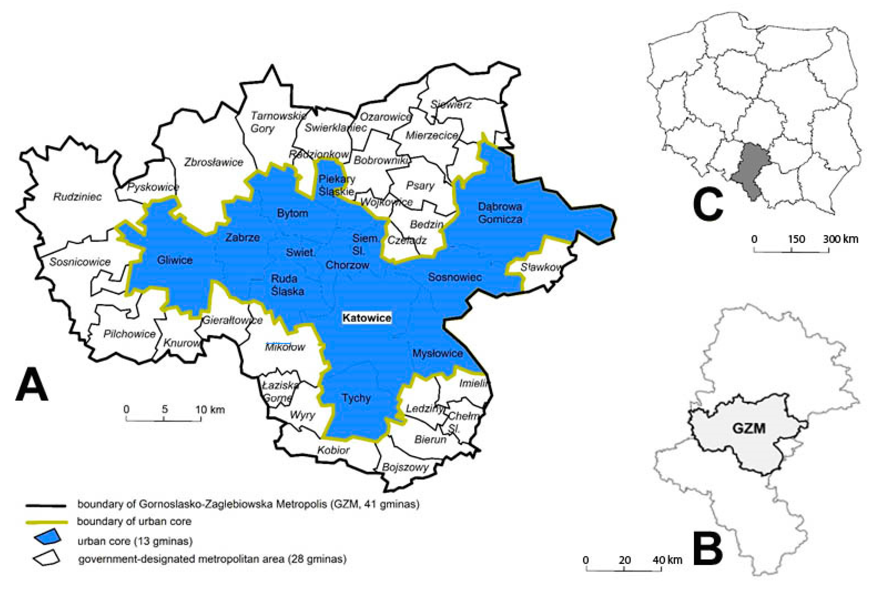
3. Research Area

Our research area is a cluster of 13 core cities of the Górnośląsko-Zagłębiowska Metropolis (Figure 1). Their common denominator is their status as cities that, at the same time, function as separate districts (in Polish: powiat grodzki), which means they are the largest cities. The research area defined in this way constitutes the central part of the conurbation surrounding Katowice, a very complex urban settlement. At the same time, the cities are located in the central part of the larger Silesian Province. The total area is 1064 km2.
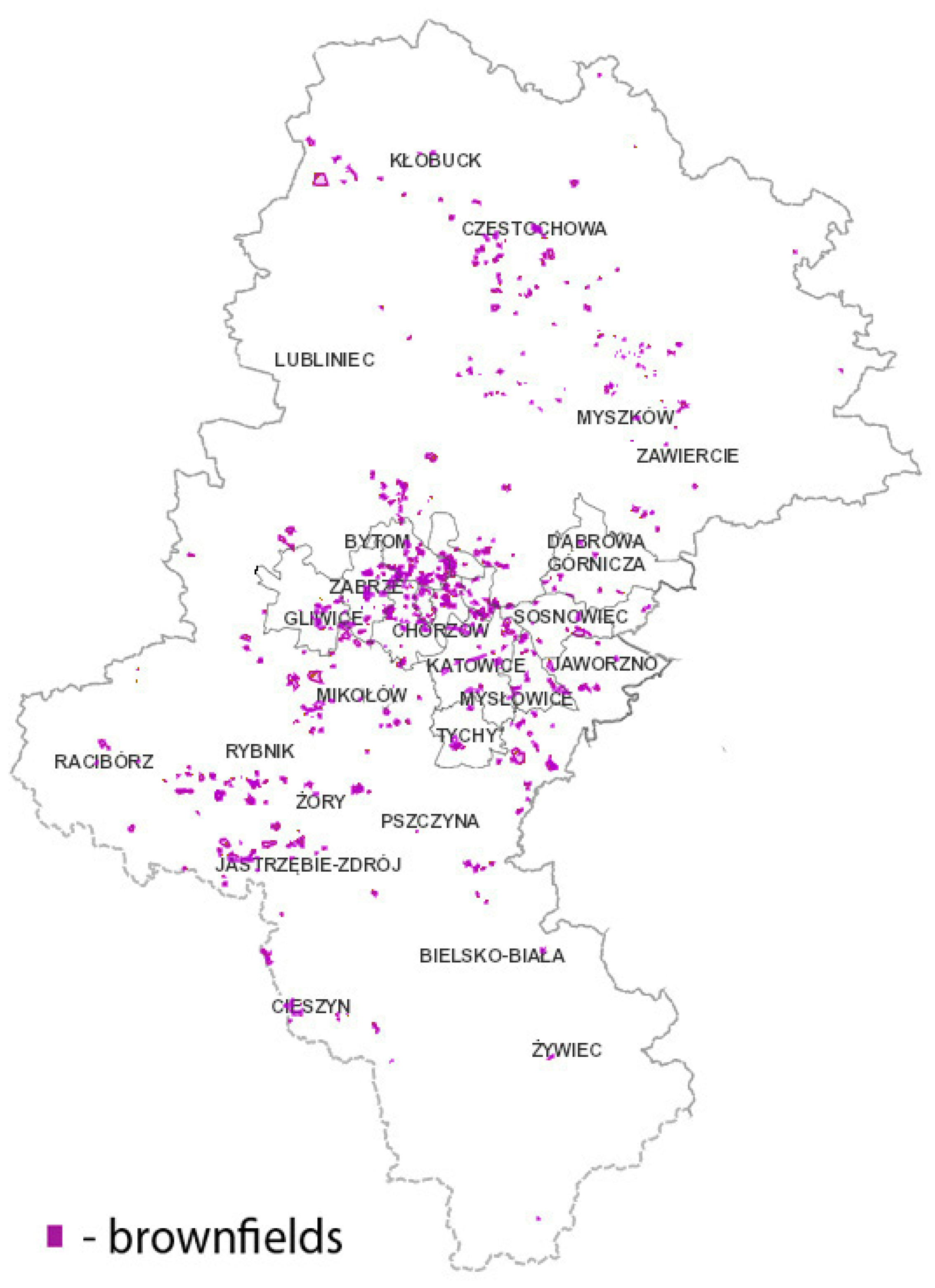
The Silesian Province is the most heavily degraded region in Poland; the share of derelict land needing reclamation is as much as 0.4%. This is due to, first of all, the intensive coal mining and coal processing that were often carried out, ignoring the environmental impact and without proper management of mining wastes.
Brownfields and other degraded areas are located primarily in the central part of the Silesian Province (the Upper Silesia Conurbation) (Figure 2). In addition, such areas are to be found in the neighborhood of Rybnik (related to coal mining) and in the belt stretching from Zawiercie to Częstochowa (related to iron ore mining).
The Silesian Province has the biggest share of degraded and polluted land in Poland. As the only province in Poland, it exceeds 0.4% of such land, which is considerably more than in the second most degraded Greater Poland Province. The least degraded Subcarpathian and Masovian Provinces only have about one quarter of this share. Nevertheless, there are many companies that play a significant role in central and eastern Europe [99]; however, apart from Jastrzębska Spółka Węglowa, they are not important in the global economy [100].
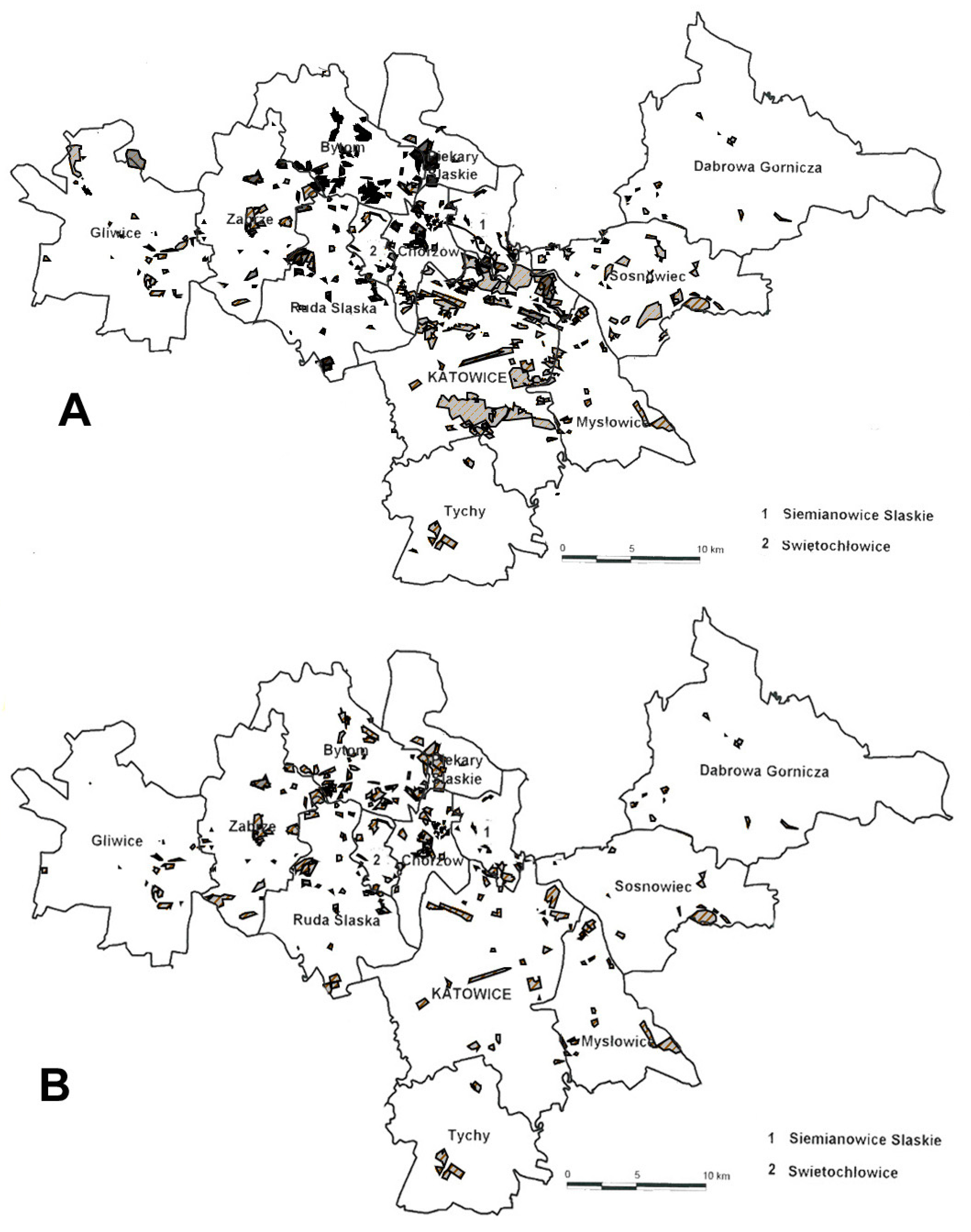
The prevalence of brownfields is another issue. The cities under analysis have the biggest shares of them in the whole of Poland, and the resulting degradation exerts a negative impact on the image of the region. Degraded brownfields may be given a new life through regeneration, which involves adapting them for new socio-economic functions, improving their appearance, and raising the living standards there.
The Act on Regeneration came into force in Poland in 2015. Unfortunately, the regulations of this Act do not sufficiently support the process of the regeneration of brownfields, as they may conditionally be accepted for regeneration only if the undertaken intervention will contribute to solving social problems. In other words, regeneration is supposed to happen in inhabited areas, while brownfields are inherently areas that are not inhabited. The delimitation of socially degraded areas must be a verifiable process, based on relevant numerical data [101,102]. It seems that, particularly in the Silesian Province, effective and comprehensive regeneration should include brownfields [103]. In the cities under analysis, raising the living standards in the neighborhood of degraded brownfields undoubtedly requires adapting these brownfields for new functions, which would change their role for the local community. Therefore, the Act should be amended so as to obligatorily include such areas in regeneration processes instead of accepting them conditionally.

4. Data and Methodology

There are two main sources of data for this study.
1. Information on the location of brownfields was obtained from ORSIP, the Open Regional System of Spatial Information—the Geoportal of the Silesian Province, created in order to make available spatial data, i.e., interactive maps and related services. ORSIP provides rich and up-to-date data and information related to the Silesian Province, originating from various institutions. The system possesses numerous functions that enable the user, inter alia, to search for specific objects, carry out spatial analyses, create a land profile, browse historical data, and access data from external sources. The present land development in the brownfields under analysis was verified on the basis of an orthophotomap from 2018, and we also used an unmanned aerial vehicle (a drone) to facilitate the identification of brownfields and post-industrial sites in our field research.
2. Information on the changing functions of post-industrial sites was obtained on the basis of field research. In-depth interviews were conducted with 5 representatives of local entrepreneurs and with 10 representatives of local governments from the cities within the research area. They focused on the transformation process and the final function of brownfields that underwent transformation. We also used secondary sources: published research and thematic reports prepared by public institutions. Our research was carried out in July and August 2020.
The research procedure was aimed at the identification of the factors that determine the new forms of land use as regards brownfields. We verified two potential factors influencing the change of function:
-
first, whether there is any correlation between the former and the new function of a brownfield;
-
second, whether the size of a brownfield determines its new function.
As we deal with qualitative features here, we used the χ2 test of independence [1] [104], followed by Cramer’s V test [2] based on the results of the test of independence.
χ 2 = i = 1 k j = 1 r ( n ij n ^ ij ) 2 n ^ ij
where n ^ ij is the expected value for the ith row and jth column, and n ij is the observed value for the ith row and jth column.
The χ2 test is used to determine if two variables are independent. Verification involves the comparison of the obtained χ2 result with the χ2 distribution table. If our result is higher than the critical value for a required significance level and given degrees of freedom, we reject the null hypothesis that the variables are statistically independent.
V = χ 2 n min ( r 1 ,   k 1 )
where r is the number of rows, and k is the number of columns.
Cramer’s V is a post-test that indicates only the strength of association. The result is a number between 0 and 1, and the higher the number, the stronger the association between the variables.

5. Results

Our results are presented in two parts, the former related to brownfields, and the latter to post-industrial sites.

5.1. Changing Functions of Brownfields

Brownfields exist in all the cities belonging to the Górnośląsko-Zagłębiowska Metropolis. Considering the whole area as a region with a polycentric structure (Figure 1), brownfields are more abundant in the western part of the region under analysis (Figure 3), i.e., in cities such as Bytom, Zabrze and Chorzów. In the past, during the period of intensive industrialization, these cities functioned as heavy industry centers, including, first and foremost, coal mining and metallurgy. Brownfields are less abundant in younger cities such as Dąbrowa Górnicza and Sosnowiec, in the eastern part of the Górnośląsko-Zagłębiowska Metropolis.
When we compare the densities of post-industrial sites at the turn of the 21st century and in 2018, we see a large reduction in their total surface area, which reflects the advancement of the transformation process. Katowice, the capital of the region and the biggest city of the Górnośląsko-Zagłębiowska Metropolis (Figure 3), has been undergoing the most dynamic transformation. The biggest brownfield is the working of the Sand Mine Bór-Maczki (Scheme 1), covering a total area of over 550 hectares, situated in the south-eastern part of Sosnowiec.
The cities under analysis exhibit significant shares of brownfields. Zabrze possesses the highest share of brownfields, as their area exceeds 8% of the total area of the city. Significant shares over 7% are observable in Świętochłowice, Siemianowice Śląskie and Sosnowiec. Tychy and Dąbrowa Górnicza, in turn, have the smallest shares of brownfields, below 1% (Table 2).
The database of degraded land contains 230 items, with a total area of 3970 ha (Table 2). However, not all of these areas may be ascribed a post-industrial origin, strictly speaking. The degraded land also encompasses housing estates (usually adjacent to big industrial facilities and built for their employees), disused military areas and railway infrastructure. Another type is the degraded forests which were affected by land subsidence and flooded with groundwater.
Finally, when such areas were excluded, we obtained 170 items with the total area of 3119 ha, which accounts for nearly 79% of all the land included in the database. These were grouped into five categories:
  • brownfields;
  • post-industrial sites;
  • mine dumps, dumping sites, landfill sites;
  • settling ponds;
  • workings.
The succession of function shows that the most popular new form of land use is green spaces (Table 3). This applies in particular to mine dumps and to disused settling ponds and workings, i.e., places with a deformed surface, with non-natural bed composition. In a sense, it is a continuation of the reclamation process. Brownfields, in turn, are often adapted for new production functions or services. The latter function is more prevalent than the former for post-industrial sites. Housing is relatively rare, and mainly appears in post-industrial sites. This may reflect the limited attractiveness of such areas from the perspective of housing, or, possibly, easy access to available land that has not been developed yet. Transportation is another unpopular function.
The trajectory of succession shows a certain regularity: the new functions are typically the closest to the former land use, which seems logical. Such solutions are usually the easiest and the cheapest, and they enable investors to make optimal use of the existing infrastructure. Although these transformation paths are logical and understandable, the statistical dependence is weak. This results from a variety of new functions for different types of areas.
On the basis of the data presented in Table 4, we calculated χ2, and obtained the result 49.75. The distribution table shows the critical value of 21.016 for the significance level α = 0.05 and 12 degrees of freedom. As χ2 = 49.75 > χ2α = 21.026, we conclude that there is a statistical dependence between the former form of land use and the new function. However, Cramer’s V, calculated on the basis of this result, is 0.24, which indicates that the association is statistically weak.
There is a correlation between the size of the area and new forms of land use (see Table 5). Services clearly dominate for small areas not exceeding 1 hectare. Green spaces are the most typical new function for areas between 1 and 20 hectares, and areas between 1 and 5 hectares are optimal for recreational purposes. Larger plots, between 20 and 100 hectares, are typically adapted for production, and areas exceeding 100 hectares do not have a dominating function.
On the basis of the data presented in Table 5, we calculated χ2, and obtained the result 44.85. Taking into consideration the small number of elements, we joined together the two last classes, i.e., areas between 50 and 100 hectares and those above 100 hectares. The distribution table shows the critical value of 37.652 for the significance level α = 0.05 and 25 degrees of freedom. As χ2 = 44.85 > χ2α = 37.652, we conclude that there is a statistical dependence between the former form of land use and the size. However, the Cramer’s V calculated on the basis of this result is 0.17, which indicates that the association is statistically weak.

5.2. Changing Functions of Post-Industrial Sites

The in-depth interviews we carried out enabled us to diagnose the processes taking place in brownfields of one specific type, i.e., post-industrial sites. The interviewed experts indicated that brownfields and post-industrial sites situated in the cities under analysis are becoming more and more attractive for investors. The number of housing, industrial and trade investments is on the rise. Big production facilities are disappearing, particularly from city centers, and they are being replaced by services and trade. This results from launching new SMEs and from the cooperation between local governments and private entrepreneurs. The latter is crucial for creating new trends in the adaptation of post-industrial sites. Such initiatives may be aptly illustrated with the companies functioning on the site of the former coal mine “Sosnowiec”, which provide leisure entertainment (a climbing wall, a gym, a fitness center). Zabrze, in turn, possesses a new tourist complex (including a museum and a restaurant), a part of the Industrial Heritage Route, on the site of the former coal mine “Concordia” (Appendix A).
Our analysis shows that the most typical reclamation of post-industrial sites involves turning them into commercial offices; the schshare of such adaptations is 23% (Table 6). In addition, buildings used for trade and services have a considerable share (16%). Less popular adaptations include those for the needs of entertainment, gastronomy and services, housing and production. The fact that only 2% of the sites under analysis are now functioning as production facilities reflects the replacement of industry by the service sector; the original industrial function has been maintained very rarely. The share of museums and entertainment facilities reflects the involvement of public funds, and we may suspect that in such cases local governments acted as the main investors. This is notable, as, on the one hand, local communities can profit from such facilities, but, on the other hand, they generate a long-term financial burden for local governments. Adaptations of this type are often stimulated by available EU funds. It seems that giving these sites a commercial function would be more beneficial from the perspective of local public funds as well as the labor market.

6. Discussion

In most countries of western Europe, there is a long tradition of undertaking reclamation activities aimed at giving brownfields back to local communities. According to Ref. [105], European projects of this type are characterized by their impressive scale, such as, for instance, the regeneration of the former port in Hamburg, now HafenCity, of the London Docklands, or of the gas tanks in Vienna, now Gasometer A, B, C, D. The housing function is combined with trade, culture and offices, so as to create a comfortable living space with easy access to all necessary services. Jones and Evans [106] mentioned that new city fragments in the UK were created in brownfields. In the GZM, as our research shows, the transformations have limited scope. Usually, only selected fragments of old facilities are adapted, while the rest is demolished.
This results from the large area of brownfields in the region under analysis, which have undergone stronger environmental transformations [107,108,109,110]. Thanks to various initiatives launched by local governments and private entrepreneurs, as well as projects aimed at regeneration, environmental protection and conservation of cultural heritage, the brownfields under analysis develop their new functions. Regenerated areas are used for production and create economic zones. Facilities are often adapted for mixed functions. In particular, regenerated post-industrial sites, i.e., mining facilities with unique architecture, serve tourism [111], culture, entertainment and recreation, or become places of other creative activities [112]. Therefore, they provide the basis for the new symbolic functions that modernize the old post-industrial region, freeing it from path dependence [98] and launching the modern phase of its economic development [113].
The regeneration activities undertaken for a few decades in the Ruhr in Germany are a great example of how old brownfields may be returned to cities [114,115,116]. Thanks to integrated regeneration projects [117] that take into consideration the best interest of inhabitants, reclamation of the natural environment, and conservation of post-industrial heritage, the region’s image changed from an industrial melting pot to a land of greenery. Mine dumps were adapted for recreation areas [118]. The authors show that regeneration of brownfields may take many divergent forms, but, independently of its actual form, it exerts a profound influence on the evolution of urban space. The preserved post-industrial facilities are now landmarks, symbols of the region providing a basis for the development of tourism and recreation [9,13,115,117,119,120]. The region is also famous for its cultural events (Essen was the European Capital of Culture in 2010). Gospodini, [28] is another author discussing landscape transformations in a post-industrial city.
The situation in GZM is similar. The results of our research also indicate high variability of transformations, which produced, inter alia, office blocks, shopping centers, museums and galleries. Among the directions of transformations of brownfields, the most popular involve their adaptation for green spaces, new services or new types of production (see Table 4). These activities confirm the findings of [121], who indicates that the Paris conurbation is a model example of regeneration of brownfields, which, since the late 1970s, have been transformed into green spaces and recreation areas. In the center of Toronto, in turn, brownfields have been adapted for housing, which aims at improving the quality of city life [122]. Nevertheless, many cities, for example in Estonia, are less successful in this respect and struggle with the problem of adaptation of degraded brownfields due, first of all, to lack of assistance from state authorities [123]. In addition, Poland and the GZM struggle with such problems when, due to inadequate legal regulations and policies of authorities, some brownfields are unable to find a new investor and gain new functions for many years, or even decades [124], and regenerated brownfields remain empty spaces [125,126]. Many brownfields also possess their own paths of development, which may depend on a variety of political, economic, social and cultural factors.
Detrick [127] analyzes the transformation in Pittsburgh, Pennsylvania, and its surroundings. When the region lost its economic basis in the 1980s, partnership between private and public investors evolved and included also NGOs and local activists into the city planning and regeneration activities. The resulting successful regeneration has made Pittsburgh a model for other areas going through transition periods. The situation looks similar in cities of the GZM, which is confirmed by our in-depth interviews. The interviewed experts perceived complex administrative procedures and the time required to settle the legal status of premises as the biggest hindrances. Infrastructural limitations constitute another hurdle. Nevertheless, according to [128], regeneration practices in Polish urban areas often diverge from how the term is understood by scholars and experts. He undertakes an attempt to identify the main problems related to regeneration of urban space in Poland, which constitute key challenges for urban policies. Author emphasises the need for social participation and cooperation of diverse stakeholder groups in generation policies at the stage of both planning and implementation.
Balsas [129] discussed the practical use of the business improvement districts (BID) mechanism in the regeneration of the city center in Stockton, California. He argued that this mechanism may solve many problems that trouble city centers nowadays. His key discovery was that the proactive implementation of regeneration mechanisms for urban areas may raise living standards for local communities and the potential for economic development, partly because of the role played by entrepreneurship. Balas enumerated his guidelines for the successful implementation of the urban regeneration strategies addressed at entrepreneurs. Similar business improvement districts also emerge in the cities under analysis. We see that some of the post-industrial sites now house Science and Technology Parks.
Konior and Pokojska [130] presented their research on the role of cultural heritage in the regeneration processes of selected brownfields in Poland. They showed that cultural heritage should not be treated as a separate category, because it becomes visible in many different realms, i.e., in the spatial, social and economic aspects of regeneration processes. They illustrated this with numerous examples identified within the study, showing benefits resulting from including cultural heritage in regeneration. By analogy, we present nearly 40 examples of sites in the cities under analysis where an important role in regeneration processes was played by cultural heritage. The authors have shown that post-industrial sites are adapted to many various spheres of life. Consequently, they confirm the findings of Ref. [5], which indicate that transformations of brownfields are part of sustainable development.

7. Final Conclusions

The cities of the Górnośląsko-Zagłębiowska Metropolis considered in our analysis possess many brownfields, and a large part of these is available for future investments. Our results show that the main transformation trends involve the adaptation of post-industrial sites for the needs of commercial offices, trade and services. The key role in the process is played by investors, both local governments and private entrepreneurs. Experts observe a significant rise in the demand among investors for post-industrial sites, which, a short time ago, were still seriously underappreciated. Entrepreneurs seek land for logistics centers, housing estates, shopping malls, etc. Brownfields in the Silesian Province attract investors with their advantageous locations.
Our research on the changing use of brownfields shows that the most popular new form of land use is green spaces, which applies particularly to mine dumps, dumping sites, disused settling ponds and workings. Production and services dominate among the new functions of brownfields. This probably results from the ease of passage from the old to the new function.
We also reveal a correlation between the size of a brownfield and its form of land use, which results from the specific needs of particular functions. Companies in the service sector usually need only a small area; consequently, services dominate for areas below 1 hectare. Green spaces fit very well into middle-sized areas (between 1 and 20 hectares), while production requires larger areas. The largest areas may perform a variety of co-existing functions, which do not clash with one another.
The area under analysis here particularly needs the adaptation of brownfields as a prerequisite for the effective transformation of its urban tissue. It is not possible to create a new positive image of these cities as long as their urban space is full of degraded brownfields. Regeneration activities should, on the one hand, contribute to improving the living standards of the local communities, and, on the other hand, restore appropriate land rent. Above all, the successful adaptation of brownfields is a crucial part of restoring the spatial order. Improving the appearance of such sites results in their removal from the group of undesirable areas in urban space.
The available ORSIP database does not provide full and complete information about present land use in brownfields and degraded areas under analysis here. It does not contain information on the part of a brownfield that has been adapted for use. The fact that a new function has emerged does not tell us what share of the brownfield is in use. Consequently, in spite of the successive functions, large parts of brownfields still await adaptation. We recommend that the database should be updated and expanded, as it constitutes an offer extended to potential investors by individual cities, as well as the Metropolis as such. The research method proposed here, aimed at identifying the factors that determine new land use forms as regards brownfields, has limitations, but it is universal and can be repeated in future research on the transformations of brownfields in other countries. The authors show that both the type of brownfield and its size determine the emergence of new functions.
To sum up, we conclude that brownfields and post-industrial sites should become a priority for local governments, as their potential may allow cities to transform their image and, consequently, to become much more attractive both for inhabitants and for investors.

Author Contributions

S.S. prepared the following elements of the article: the methodology, conclusions; S.P. prepared the following elements of the article: the methodology, conduct of research, developed the final contents of the article and proofread and revised it. M.C. prepared the following elements of the article: the methodology, introduction, review of the literature. E.Z.-Ż. prepared the following elements of the article: the methodology, introduction and conclusions, conduct of research, calculations. A.R. review and editing, data correction. J.M.-P. prepared the following elements of the article: the methodology, conduct of research, calculations. All authors have read and agreed to the published version of the manuscript.

Funding

This research received no external funding.

Institutional Review Board Statement

Not applicable.

Informed Consent Statement

Not applicable.

Data Availability Statement

Data available on request.

Conflicts of Interest

The authors declare no conflict of interest.

Appendix A

Table A1. Changing functions of post-industrial sites.
CityPresent NamePrevious UsePresent Function
BytomCH (Shopping Centre) Szombierki Coal mine Szombierki Trade and services
BytomArmada Golf ClubCoal mine Szombierki Recreation
BytomBolko LoftLamp room of the coal mine and foundry Orzeł Biały Housing
BytomBytomski Teatr Tańca i Ruchu (Bytom Theatre of Dance and Movement) RozbarkSight room of the coal mine RozbarkCulture and entertainment
BytomSportowa Dolina (Sports Valley)Dolomite mineRecreation
ChorzówSzyb (Shaft) Prezydent and Kompleks (Complex) SztygarkaCoal mine PolskaGastronomy and services
Dąbrowa GórniczaCH (Shopping Centre) PogoriaIronworks Bankowa Trade and services
Dąbrowa GórniczaFabryka Pełna Życia (Factory Full of Life)Factory of machine tools DefumCulture and entertainment
GliwiceForum Centrum Handlowe (Shopping Centre)Factory of refractory materials Trade and services
GliwiceNowe Gliwice – Centrum Edukacji i Biznesu Inkubator Przedsiębiorczości (New Gliwice – Education and Business Centre, Business Incubator)Coal mine GliwiceCommercial offices
GliwiceOddział Odlewnictwa Artystycznego (Artistic Foundry Division)Royal cast iron foundry Museum
GliwiceLoftGranaryHousing
KatowiceSilesia City CenterCoal mine Kleofas (previously Gottwald/Eminencja)Trade and services
KatowiceDL AtriumPrinting houseCommercial offices
KatowiceBrowar (Brewery) Factory CentrumBrewery of the Mokrski family in SzopieniceCommercial offices
KatowiceStara Huta (Old Zinc Works)3 rooms of the zinc works Silesia in WełnowiecCommercial offices
KatowiceSilesia for Business – under constructionCoal mine KleofasCommercial offices
KatowicePorcelana Śląska (Silesian Porcelain) ParkPorcelain factory GiescheCommercial offices
KatowiceMuzeum Hutnictwa Cynku WALCOWNIA (Zinc Metallurgy Museum ROLLING MILL)Rolling mill of the zinc works UthemannMuseum
KatowiceMuzeum Śląskie (Silesian Museum)Coal mine KatowiceMuseum
KatowiceGaleria Szyb (Gallery Shaft) WilsonCoal mine WieczorekCulture and entertainment
KatowiceGPP Business ParkDump of the zinc works Silesia in WełnowiecCommercial offices
KatowiceEuro-Centrum Park Naukowo-Technologiczny (Science and Technology Park)Chemical apparatus factory WimachCommercial offices
KatowiceSilesia Business ParkIronworks BaildonCommercial offices
KatowiceMacro Cash&CarryDump of the coal mine KleofasServices
MysłowiceKompleks Bankietowo-Konferencyjny Szyb (Banquet and Conference Complex Shaft) BończykCoal mine MysłowiceGastronomy and services
Ruda ŚląskaStara Drukarnia (Old Printing House)Printing houseGastronomy and services
Ruda ŚląskaŚląski Park Przemysłowy (Silesian Industry Park)Coal mine Walenty-WawelCommercial offices
Ruda ŚląskaCH (Shopping Centre) Plaza and CH (Shopping Centre) DominoDumps of the zinc works Liebe-HofnungTrade and services
Siemianowice ŚląskieSCK - Park Tradycji (Tradition Park)Engine room of the shaft Krystyn in the coal mine MichałServices
Siemianowice ŚląskieLofty (Lofts)BreweryHousing
SosnowiecPlejada Centrum Handlowe (Shopping Centre)Ironworks Katarzyna, dumps of coal minesTrade and services
SosnowiecKatowicka Specjalna Strefa Ekonomiczna (Katowice Special Economic Zone)Coal mine SosnowiecServices
SosnowiecPoziom (Level) 450Shaft Anna in the coal mine SosnowiecRecreation
SosnowiecSosnowiecki Park Naukowo-Technologiczny (Sosnowiec Science and Technology Park)Coal mine Niwka-ModrzejówServices
Świętochłowice Baterpol S.A.Silver and lead works Walther Croneck/ zinc works SilesiaProduction
ŚwiętochłowiceWieże KWK Polska (Towers of the coal mine Polska)2 hoist towers of the coal mine PolskaServices
TychyMuzeum Tyskich Browarów Książęcych (Museum of the Ducal Brewery in Tychy)BreweryMuseum
TychyBrowar Obywatelski (Citizens’ Brewery)BreweryServices
ZabrzePlatan CH (Shopping Centre)Ironworks of the Donnersmarck family (ironworks Zabrze SA)Trade and services
ZabrzeSztolnia Królowa Luiza (Adit Queen Louise)Coal mine Królowa LuizaCulture and entertainment
ZabrzeKopalnia (Coal Mine) Guido Coal mine GuidoCulture and entertainment
ZabrzeSzyb (Shaft) MaciejShaft Maciej of the coal mine Pstrowski (Concordia)Gastronomy and services
Source: Authors’ own elaboration.

References

  1. DYREKTYWA 2004/35/WE PARLAMENTU EUROPEJSKIEGO I RADY z dnia 21 kwietnia 2004 r. w sprawie odpowiedzialności za środowisko w odniesieniu do zapobiegania i zaradzania szkodom wyrządzonym środowisku naturalnemu. (Dz. U. L 143/56 z 30.4.2004).
  2. DYREKTYWA RADY z dnia 27 czerwca 1985 r. w sprawie oceny skutków wywieranych przez niektóre przedsięwzięcia publiczne i prywatne na środowisko naturalne 85/337/EWG (Dz.U. L 175 z 5.7.1985, str. 40).
  3. DYREKTYWA PARLAMENTU EUROPEJSKIEGO I RADY 2010/75/UE z dnia 24 listopada 2010 r. w sprawie emisji przemysłowych (zintegrowane zapobieganie zanieczyszczeniom i ich kontrola) (Dz. U. L 334/17 z 17.12.2010).
  4. Gasidło, K. Przekształcenia terenów poprzemysłowych—Efekty i perspektywy badań i działań. Problemy Ekologii. 2008, 12, 76–80. [Google Scholar]
  5. Białecka, B.; Biały, W. Tereny pogórnicze–szanse, zagrożenia. Analiza przypadku. PA NOVA 2014, 10–14. [Google Scholar]
  6. Program rządowy dla terenów poprzemysłowych Governental Programme for Post-Industrial Areas. 2004. Available online: https://docplayer.pl/542328-Program-rzadowy-dla-terenow-poprzemyslowych.html (accessed on 1 December 2020).
  7. Domański, B. Tereny poprzemysłowe w miastach polskich—kierunki i bariery przekształceń. In Miasto Postsocjalistyczne Organizacja Przestrzeni I Jej Przemiany, Xiii Konwersatorium Wiedzy O Mieście; Jażdżewska, I., Ed.; Wydawnictwo Uniwersytetu: Łódzkiego, Poland, 2000; pp. 139–143. [Google Scholar]
  8. Geiß-Netthövel, K.; Nellen, D.; Sonne, W. Vom Ruhrgebiet zur Metropole Ruhr. SVR KVR RVR 1920–2020; Jovis: Berlin, Germany, 2020. [Google Scholar]
  9. Joly, N. Creating a new image for an old industrial region. An analysis of touristic iconography in the Ruhr Area. Die Erde. 2003, 134, 23–41. [Google Scholar]
  10. Wehling, H.W. Aufbau, Wandel und Perspektiven der industriellen Kulturlandschaft des Ruhrgebiets. Geographische Rundschau 2006, 58, 12–19. [Google Scholar]
  11. Hoppe, W.; Keil, A.; Makowa, K.; Schneider, W.; Schulte-Derne, F. Das Ruhrgebiet im Strukturwandel (Diercke Spezial); Westermann: Braunschweig, Germany, 2010; p. 124. [Google Scholar]
  12. Prossek, A.A. Coal Mine is not a Coal Mine: Image Improvement and Symbolic Representation of the Ruhr Area, Germany City Images and Urban Regeneration; Eckardt, F., Kreisl, P., Eds. Eur. City Trans. 2004, 3, 67–81. [Google Scholar]
  13. Chmielewska, M. Tourism as a way of revitalization of post-industrial landscape: The Industrial Heritage Trail in Ruhr Area (Germany); Rahmonov, O., ed. Anthropogen. Aspects Landscape Transform. 6 Sosnowiec Będzin 2010, 6, 11–15. [Google Scholar]
  14. Zöpel, C. IBA-Emscherpark – vom Ende des „Ruhrgebiets“ zum Anfang von „Ruhrbanität“. In Forum Geschichtskultur Ruhr, Themenschwerpunkt "100 Jahre geplantes Ruhrgebiet. Vom Siedlungsverband Ruhrkohlenbezirk zum Regionalverband Ruhr"; Heft 1/2020; Deutsche Rentenversicherung: Berlin, Germany, 2020; pp. 16–21. [Google Scholar]
  15. Shaw, R. The international building exhibition (IBA) Emscher Park, Germany: A model for sustainable restructuring? Eur. Plan. Stud. 2002, 10, 77–97. [Google Scholar] [CrossRef]
  16. Seltmann, G. Die IBA Emscher Park im Kontext der Stadtentwicklungspolitik für Nordrhein-Westfalen. In Zukunft Denken Und Verantworten; Springer VS: Wiesbaden, Germany, 2020; pp. 623–629. [Google Scholar]
  17. Selter, V. Selected Examples of Remediation and Reactivation of Old Sites in the Ruhr Region. Soil Groundwater Remed. Technol. Pract. Guide 2020, 315, 93. [Google Scholar]
  18. Kirk, J.; Jefferys, S.; Wall, C. Representing identity and work in transition: The case of South Yorkshire coal-mining communities in the UK. In Changing Work and Community Identities in European Regions; Palgrave Macmillan: London, UK, 2012; pp. 184–216. [Google Scholar]
  19. Faull, M.L. Coal mining and the landscape of England, 1700 to the present day. Landsc. Hist. 2012, 30, 59–74. [Google Scholar] [CrossRef]
  20. Beatty, C.; Fothergill, S.; Powell, R. Twenty years on: Has the economy of the UK coalfields recovered? Environ. Plan. A 2007, 39, 1654–1675. [Google Scholar] [CrossRef] [Green Version]
  21. Dormard, S. L’économie du Nord-Pas-de-Calais: Histoire et bilan d’un demi-siècle de transformations; Presses Universitaires du Septentrion: Berlin, Germany, 2001; p. 320. [Google Scholar]
  22. Paris, D. La mutation inachevée: Mutation économique et changement spatial dans le Nord-Pas-de-Calais. L’Harmattan 1993, 365. [Google Scholar]
  23. Liefooghe, C. Old industrial regions (II)-Nord-pas-de-Calais. Regions Mag. 2005, 259, 13–16. [Google Scholar] [CrossRef]
  24. Leboutte, R. A space of European de-industrialisation in the late twentieth century: Nord/Pas-de-Calais, Wallonia and the Ruhrgebiet. Eur. Rev. Hist. Rev. Eur. Hist. 2009, 16, 755–770. [Google Scholar] [CrossRef] [Green Version]
  25. Conzelmann, T. Networking and the politics of EU regional policy: Lessons from north Rhine-Westphalia, Nord-Pas de Calais and North West England. Reg. Fed. Stud. 1995, 5, 134–172. [Google Scholar] [CrossRef]
  26. Loures, L.; Panagopoulos, T. From derelict industrial areas towards multifunctional landscapes and urban renaissance. WSEAS Trans. Environ. Dev. 2007, 3, 181–188. [Google Scholar]
  27. Loures, L.; Panagopoulos, T. Recovering derelict industrial landscapes in Portugal: Past interventions and future perspectives. In Proceedings of the Int. Conf. on Energy. Environ. Ecosyst. Sustain. Dev. 2007, 116–121. [Google Scholar]
  28. Gospodini, A. Post-industrial trajectories of Mediterranean European cities: The case of post-Olympics Athens. Urban. Stud. 2009, 46, 1157–1186. [Google Scholar] [CrossRef] [Green Version]
  29. Kennedy, L. Remaking Birmingham: The Visual Culture and Urban. Regeneration; Ashgate: Aldershot, UK, 2004. [Google Scholar]
  30. Adams, D.; Watkins, C. Greenfields, Brownfields and Housing Development, Blackwell Publishing; Blackwell Science: Oxford, UK, 2002; p. 314. [Google Scholar]
  31. Hall, P. Modelling the post-industrial city. Futures 1997, 29, 311–322. [Google Scholar] [CrossRef]
  32. Nita, J.; Myga-Piątek, U. Krajobrazowe kierunki zagospodarowania terenów pogórniczych. Przegląd Geologiczny 2006, 54, 256–262. [Google Scholar]
  33. Li, P.; Braae, E.; Liu, J. Expo 2010 Strategic transformation of former industrial areas by means of international events. J. Urban. Plan. Dev. 2014, 140. [Google Scholar] [CrossRef]
  34. O’Connor, J.; Wynne, D. From the Margins to the Centre: Cultural Production and Consumption in the Post-Industrial City; Popular Cultural Studies 10; Routledge: London, UK, 2017; p. 282. [Google Scholar]
  35. Balibrea, M.P. Urbanism, culture and the post-industrial city: Challenging the Barcelona model. J. Spanish Cult. Stud. 2001, 2, 187–210. [Google Scholar] [CrossRef]
  36. Mommaas, H. Cultural clusters and the post-industrial city: Towards the remapping of urban cultural policy. Urban. Stud. 2004, 41, 507–532. [Google Scholar] [CrossRef]
  37. Couch, C.H.; Dennemann, A. Urban regeneration and sustainable development in Britain. The example of the Liverpool Ropewalks Partnership. Cities 2000, 17, 137–147. [Google Scholar] [CrossRef]
  38. Maltsev, A.A.; Mordvinova, A.E. American model of industrial areas revitalization. RUDN J. Econ. 2018, 26, 76–88. [Google Scholar] [CrossRef] [Green Version]
  39. Mallett, W.J. Managing the post-industrial city: Business improvement districts in the United States. Area 1994, 276–287. [Google Scholar]
  40. Zaitseva, N.A.; Filatov, V.V.; Larionova, A.A.; Rodina, E.E.; Makarova, L.M.; Palastina, I.P.; Hramchenko, A.A. Project management of revitalization of urban areas through the creation of industrial parks. Modern J. Lang. Teach. Methods 2018, 8, 284–297. [Google Scholar]
  41. Hu, X.; Hassink, R. New perspectives on restructuring of old industrial areas in China: A critical review and research agenda. Chin. Geogr. Sci. 2017, 27, 110–122. [Google Scholar]
  42. Lorens, P. Rewitalizacja Miast W Polsce: Pierwsze Doświadczenia; Biblioteka Urbanisty, Urbanista 10: Warszawa, Poland, 2007. [Google Scholar]
  43. Lorens, P. Rewitalizacja Miast: Planowanie I Realizacja; Wydział Architektury Politechniki Gdańskiej: Gdańsk, Poland, 2010. [Google Scholar]
  44. Dziewoński, K. Początki i przemiany planowania przestrzennego w Polsce. Biuletyn KPZK PAN 1991, 152, 65–75. [Google Scholar]
  45. Czarnecki, W. Projektowanie obiektów przemysłowych. Wydawnictwo Politechniki Białostockiej 1983, 174. [Google Scholar]
  46. Ziobrowski, Z.; Jarczewski, W. Rewitalizacja miast polskich–diagnoza. Seria Rewitalizacja Miast Polskich 2010, 8, 167–193. [Google Scholar]
  47. Gasidło, K. Problemy Przekształceń Terenów Poprzemysłowych; Wydawnictwo Politechniki Śląskiej: Gliwice, Poland, 1998. [Google Scholar]
  48. Kaczmarek, S. Rewitalizacja terenów poprzemysłowych. Nowy wymiar w rozwoju miast; Wydawnictwo Uniwersytetu Łódzkiego. Łódź: Olsztyn, Poland, 2001; p. 141. [Google Scholar]
  49. Kaczmarek, S. The Space of Exchange: Revitalisation of Post-Industrial Areas in Modern Cities. Cities in Global Perspective: Diversity and Transition; Murayama, Y., Du, G., Eds.; Rikkyo University with IGU Urban Commission: Tokyo, Japan, 2005; pp. 270–278. [Google Scholar]
  50. Kaczmarek, S. Proces rewitalizacji terenów poprzemysłowych a organizacja przestrzeni miejskiej Łodzi. In Rewitalizacja Trenów Poprzemysłowych Łodzi; Markowski, T., Kaczmarek, S., Olenderek, J., Eds.; Biuletyn KPZK PAN, t. CXXXII: Warszawa, Poland, 2010; pp. 7–18. [Google Scholar]
  51. Markowski, T.; Stawasz, D. Rewitalizacja A Rozwój Funkcji Metropolitalnych Miasta Łodzi; Wydawnictwo Uniwersytetu Łódzkiego: Łódź, Poland, 2007. [Google Scholar]
  52. Kotlicka, J. Przemiany Morfologiczne Terenów Przemysłowych Łodzi; Łódzkie Towarzystwo Naukowe: Łódź, Poland, 2008; Volume 36. [Google Scholar]
  53. Jakubczyk, Z.; Słodczyk, J. Revitalization and the sustainable development of cities: A theoretical and empirical approach. In Society, Economy, Environment—Towards the Sustainable City, University of Gdańsk, Department of Economic Geography; Sagan, I., Smith, D.M., Eds.; Bogucki Wydawnictwo Naukowe: Gdańsk–Poznań, Poland, 2005; pp. 159–175. [Google Scholar]
  54. Stawasz, D. Rewitalizacja jako kompleksowy proces stymulujący konkurencyjność miasta. In Rewitalizacja—Nośnik Tożsamości I Rozwoju Obszarów Metropolitalnych; Walczak, B.M., Ed.; PRO-REVITA: Łódź, Poland, 2006. [Google Scholar]
  55. Ziobrowski, Z.; Ptaszycka-Jackowska, D.; Rębowska, A.; Geissler, A. Odnowa miast. Rewitalizacja, Rehabilitacja, Restrukturyzacja, Instytut Gospodarki Przestrzennej I Komunalnej; Wydawnictwo Politechniki Śląskiej: Gliwice, Poland, 2000. [Google Scholar]
  56. Szajnowska-Wysocka, A.; Sobala, M. Rewitalizacja przestrzeni miejskiej w konurbacji górnośląskiej. Studia Miejskie 2013, 11, 9–25. [Google Scholar]
  57. Sitek, S.; Szajnowska-Wysocka, A. Proces rewitalizacji obszarów poprzemysłowych i jego wpływ na krajobraz miejski. Dissertations Cultural Lands. Comm. 2018, 40, 225–242. [Google Scholar] [CrossRef]
  58. Krzysztofik, R.; Kantor-Pietraga, I.; Kłosowski, F. Between Industrialism and Postindustrialism—the Case of Small Towns in a Large Urban Region: The Katowice Conurbation, Poland. Urban. Sci. 2019, 3, 68. [Google Scholar] [CrossRef] [Green Version]
  59. Pęski, W. Zarządzanie Zrównoważonym Rozwojem Miast; Arkady: Warszawa, Poland, 1999. [Google Scholar]
  60. Ratajczak, N.; Drzazga, D. Rewitalizacja przyrodnicza a procesy zarządzania rozwojem miasta na przykładzie Łodzi. Teka Kom. Arch. Urb. Stud. Krajobr. OL PAN 2005, 1, 135–148. [Google Scholar]
  61. Zuziak, Z. Strategie Rewitalizacji Przestrzeni Śródmiejskiej, Seria Architektura; Wydawnictwo Politechniki Krakowskiej: Kraków, Poland, 1998. [Google Scholar]
  62. Domański, T. Marketing Terytorialny: Strategiczne Wyzwania Dla Miast I Regionów; Centrum Badań i Studiów Francuskich instytut Studiów Międzynarodowych Uniwersytet: Łódzki, Poland, 1997. [Google Scholar]
  63. Guzik, R. Rewitalizacja Miast w Wielkiej Brytanii, t. 1; Instytut Rozwoju Miast w Krakowie: Kraków, Poland, 2009. [Google Scholar]
  64. Skalski, K. Rewitalizacja We Francji: Zarządzanie Przekształceniami Obszarów Kryzysowych W Miastach; Instytut Rozwoju Miast w Krakowie: Kraków, Poland, 2009. [Google Scholar]
  65. Bryx, M.; Jadach-Sepioło, A. Rewitalizacja Miast W Niemczech; Instytut Rozwoju Miast w Krakowie: Kraków, Poland, 2009. [Google Scholar]
  66. Trzepacz, P. Przekształcenia przestrzeni urbanistycznej Berlina w drugiej połowie XX w. In Nowe Przestrzenie Miejskie Ich Organizacja I Funkcje, Xix Konwersatorium Wiedzy O Mieście; Jażdżewska, I., Ed.; Wydawnictwo Uniwersytetu Łódzkiego: Łódź, Poland, 2006; pp. 377–388. [Google Scholar]
  67. Janas, K.; Jarczewski, W.; Wańkowicz, W. Model rewitalizacji miast. Instytut Rozwoju Miast. 2010, T.10, 164. [Google Scholar]
  68. Rydzik, W. Aspekty Prawne I Organizacyjne Zarządzania Rewitalizacją; Instytut Rozwoju Miast: Kraków, Poland, 2009. [Google Scholar]
  69. Runge, J. Przeobrażenia funkcjonalno-przestrzenne miast tradycyjnego regionu społeczno-ekonomicznego—Wymiar teoretyczny. Stud. Miejskie 2018, 32, 21–33. [Google Scholar] [CrossRef]
  70. Krzysztofik, R.; Kantor-Pietraga, I.; Spórna, T. Dynamic approach to the typology of functional derelict areas (Sosnowiec, Poland). Morav. Geogr. Rep. 2013, 2, 20–35. [Google Scholar] [CrossRef] [Green Version]
  71. Jaroszewska-Brudnicka, R. Reżyserowanie przestrzeni publicznej miasta. In Człowiek W Przestrzeni Publicznej Miasta, Xxiv Konwersatorium Wiedzy O Mieście; Jażdżewska, I., Ed.; Wydawnictwo Uniwersytetu Łódzkiego: Łódź, Poland, 2011; pp. 129–140. [Google Scholar]
  72. Ziobrowski, Z.; Domański, B. Rewitalizacja miast polskich jako sposób zachowania dziedzictwa materialnego i duchowego oraz czynnik zrównoważonego rozwoju. In Podsumowanie Projektu; Wydawnictwo Instytutu Rozwoju Miast w Krakowie: Kraków, Poland, 2010. [Google Scholar]
  73. Runge, J.; Dragan, W. Funkcja miejsca w kontekście rewitalizacji przestrzeni centralnej miasta na przykładzie Mysłowic. Problemy Ekologii Krajobrazu Tom XXXVII 2014, 51–58. [Google Scholar]
  74. Pawłowski, K. Od ochrony krajobrazu miasta do mechanizmów ekonomiczno-społecznych jego rewitalizacji. Refleksje na temat norm międzynarodowych. In Rewitalizacja—Nośnik Tożsamości I Rozwoju Obszarów Metropolitalnych; Walczak, B.M., Ed.; PRO-REVITA: Łódź, Poland, 2006. [Google Scholar]
  75. Domański, B. Restrukturyzacja terenów poprzemysłowych w miastach. In Odnowa Miast. Rewitalizacja, Rehabilitacja, Restrukturyzacja, Instytut Gospodarki Przestrzennej I Komunalnej; Ziobrowski, Z., Ptaszycka-Jackowska, D., Rębowska, A., Geissler, A., Eds.; Wydawnictwo Politechniki Śląskiej: Gliwice, Poland, 2000; pp. 107–142. [Google Scholar]
  76. Kobylańska, M.; Gawor, Ł. Problematyka przeobrażeń przestrzennych w procesach rewitalizacji terenów poprzemysłowych. Stud. Ind. Geogr. Comm. Pol. Geogr. Soc. 2017, 31, 68–80. [Google Scholar]
  77. Ostręga, A.; Uberman, R. Formalnoprawne problemy rewitalizacji terenów poprzemysłowych, w tym pogórniczych. Górnictwo i Geoinżynieria 2005, 29, 115–127. [Google Scholar]
  78. Skalny, A.; Białecka, B. Kierunki przekształceń terenów poprzemysłowych—analiza przypadków. Zeszyty Naukowe. Organizacja i Zarządzanie/Politechnika Śląska 2015, 82, 227–239. [Google Scholar]
  79. Knox, P.; KcCarthy, L. Urbanization. In An Introduction to Urban Geography, 2nd ed.; Pearson: London, UK, 2005. [Google Scholar]
  80. Gaddes, O. Cities in Evolution; Williams & Norgate: London, UK, 1915; p. 442. [Google Scholar]
  81. Beaujeu-Garnier, J.; Chabot, G. Zarys Geografii Miast; PWE: Warszawa, Poland, 1971. [Google Scholar]
  82. Liszewski, S.; Maik, W. Osadnictwo, Wielka Encyklopedia Geogarfii Świata, T. 19; Wyd. Kurpisz: Poznań, Poland, 2000. [Google Scholar]
  83. Runge, J. Złożony Układ Osadniczy—Tradycyjny Region Ekonomiczny—Przestrzeń Społeczno-Kulturowa; Wyd. Uniwersytetu Śląskiego: Katowice, Poland, 2020. [Google Scholar]
  84. Lambooy, J. Polynucleation and Economic Development: The Randstad. Eur. Plan. Stud. 1998, 6, 457–466. [Google Scholar] [CrossRef]
  85. Kloosterman, R.; Musterd, S. The Polycentric Urban Region: Towards a Research Agenda. Urban. Stud. 2001, 38, 623–633. [Google Scholar] [CrossRef]
  86. Hall, P.; Pain, K. The Polycentric Metropolis: Learning from Mega-City Regions in Europe; Earthscan: London, UK, 2006. [Google Scholar]
  87. Green, N. Functional Polycentricity: A Formal Definition in Terms of Social Network Analysis. Urban. Stud. 2007, 44, 2077–2103. [Google Scholar] [CrossRef]
  88. Goess, S.; De Jong, M.; Meijers, E.J. Branding miasta w policentrycznych regionach miejskich: Identyfikacja, profilowanie i transformacja w Randstad i Renie-Ruhrze. Eur. Plan. Stud. 2016, 24, 2036–2056. [Google Scholar]
  89. Meijers, E. Polycentric Urban Regions and the Quest for Synergy: Is a Network of Cities More than the Sum of the Parts? Urban. Stud. 2005, 42, 765–781. [Google Scholar] [CrossRef]
  90. Sitek, S.; Runge, J.; Kłosowski, F.; Runge, A.; Petryszyn, J.; Pytel, S.; Spórna, T.; Kurpanik, M.; Zuzańska-Żyśko, E. Społeczno-Gospodarcze Oraz Przestrzenne Kierunki Zmian Regionalnego Oraz Lokalnych Rynków Pracy Województwa Śląskiego: Raport Końcowy; Wydział Nauk o Ziemi Uniwersytetu Śląskiego: Sosnowiec, Poland, 2013. [Google Scholar]
  91. Batten, D. Network cities: Creative urban agglomerations for the 21st century. Urban. Stud. 1995, 32, 313–327. [Google Scholar] [CrossRef]
  92. Zuzańska-Żyśko, E. Polycentricity and commuting an application to metropolitan areas in the south of Poland. Acta Geobalcanica 2018, 2, 77–84. [Google Scholar]
  93. Zuzańska-Żyśko, E. Role of Advanced Producer Services Shaping Globalization Processes in a Post-Industrial Region: The Case of the Górnośląsko. Zagłebiowska Metropolis. Sustainability 2021, 13, 1–19. [Google Scholar]
  94. Dorocki, S.; Raźniak, P.; Winiarczyk-Raźniak, A. Changes in the command and control potential of European cities in 2006–2016. Geogr. Pol. 2019, 92, 275–288. [Google Scholar] [CrossRef] [Green Version]
  95. Gwosdz, K. Pomiędzy Starą i Nową Ścieżką Rozwojową. In Mechanizmy Ewolucji Struktury Gospodarczej i Przestrzennej Regionu Tradycyjnego Przemysłu na Przykładzie Konurbacji Katowickiej po 1989 Roku; IGiGP UJ: Kraków, Poland, 2014. [Google Scholar]
  96. Domański, B. Foreign capital and the development of Polish regions. Czasopismo Geograficzne. 2011, 82, 173–187. [Google Scholar]
  97. Leszczycki, S.; Tokarski, Z. Niektóre Problemy Warunków Bytowych w Górnośląskim Okręgu Przemysłowym; Ossolineum: Warszawa, Poland, 1970. [Google Scholar]
  98. Sagan, R.; Sitek, S.; Szajnowska-Wysocka, A. The impact of globalization on regional identity: The example of Silesian identity. Bull. Geogr. Socio Econ. Ser. 2020, 48, 83–111. [Google Scholar] [CrossRef]
  99. Raźniak, P.; Dorocki, S.; Winiarczyk-Raźniak, A.; Płaziak, M.; Szymańska, A.I. Lokalizacja ośrodków kontroli i zarządzania elementem stabilności gospodarczej ośrodków miejskich w Europie Środkowo-Wschodniej. Prace Komisji Geogr. Przemysłu Polskiego Towarzystwa Geogr. 2016, 2, 38–54. [Google Scholar]
  100. Raźniak, P.; Dorocki, S.; Winiarczyk-Raźniak, A. Spatial changes in the command and control function of cities based on the corporate centre of gravity model. Miscellanea Geogr. 2020, 24, 35–41. [Google Scholar] [CrossRef] [Green Version]
  101. Sitek, S.; Zuzańska-Żyśko, E.; Klimek, M. Delimitacja obszarów na potrzeby programów rewitalizacji–aspekt metodologiczny. Studia KPZK. 2018, 12–30. [Google Scholar]
  102. Riley, R.; Tkocz, M. Coal mining in Upper Silesia under communism and capitalism. Eur. Urban. Reg. Stud. 1998, 5, 217–235. [Google Scholar] [CrossRef]
  103. Pukowiec-Kurda, K.; Vavrouchová, H. Land Cover Change and Landscape Transformations (2000–2018) in the Rural Municipalities of the Upper Silesia-Zagłębie Metropolis. Sustainability 2020, 23, 9911. [Google Scholar] [CrossRef]
  104. Sobczyk, M. Statystyka; Wydawnictwo Naukowe PWN: Warszawa, Poland, 2007. [Google Scholar]
  105. Turek, A. Rewitalizacja obszarów poprzemysłowych na cele mieszkaniowe. Problemy Rozwoju Miast. 2013, 1, 71–86. [Google Scholar]
  106. Jones, P.; Evans, J. Urban. Regeneration in the UK; Sage Publications Ltd.: London, UK, 2009. [Google Scholar]
  107. Pełka-Gościniak, J. Restoring nature in mining areas of the Silesian Upland (Poland). Earth Surf. Processes Landf. 2006, 31, 1685–1691. [Google Scholar] [CrossRef]
  108. Dulias, R. Landscape planning in areas of sand extraction in the Silesian Upland, Poland. Landsc. Urban. Plan. 2010, 95, 91–104. [Google Scholar] [CrossRef]
  109. Rzętała, M. Assessment of Toxic Metal Contamination of Bottom Sediments in Water Bodies in Urban Areas. Soil Sediment. Contam. 2015, 24, 49–63. [Google Scholar] [CrossRef]
  110. Machowski, R.; Rzetala, M.A.; Rzetala, M.; Solarski, M. Geomorphological and hydrological effects of subsidence and land use change in industrial and urban areas. Land Degrad. Dev. 2016, 27, 1740–1752. [Google Scholar] [CrossRef]
  111. Kostrubiec, B.; Lamparska-Wieland, M. Mining Tourism in Hard Coal Basins in Poland and France. In Conditions of the Foreign Tourism Development in Central and Eastern Europe; Institute of Geography and Regional Development: Wrocław, Poland, 2008; Volume 8, pp. 97–110. [Google Scholar]
  112. Koman, W.; Zuzańska-Żyśko, E. Towards creative city case study of Katowice. In Proceedings of the International Scientific Conference Geobalcanica, Skopje, Macedonia, 15–16 May 2018; pp. 325–334. [Google Scholar]
  113. Zuzańska-Żyśko, E. Procesy Metropolizacji. Teoria i Praktyka; PWN: Warszawa, Poland, 2016. [Google Scholar]
  114. Faust, H. Das Ruhrgebiet. Erneuerung einer europäischen Industrieregion. Impulse für den Strukturwandel durch die Internationale Bauausstellung Emscher Park. Eur. Reg. 1999, 7, 10–18. [Google Scholar]
  115. Krajewski, C.; Reuder, P.; Wolkersdorfer, G. Das Ruhrgebiet als postmoderner Freizeitraum. Geogr. Rundschau. 2006, 58, 20–27. [Google Scholar]
  116. Steins, C. The foundation for the preservation of industrial monuments and historical culture in Ruhr—a nationwide pioneering project. In Landscape Built on Coa; Instytut Ekologii Terenów Uprzemysłowionych: Katowice, Poland, 2008; pp. 131–140. [Google Scholar]
  117. Dickmann, F.; Diekmann-Boubaker, N. Freizeit am Wasser—Entwicklung stadtteilbezogener Revitalisierungsprojekte im Ruhrgebiet. Standort Zeitschrift Angew. Geogr. 2008, 32, 51–55. [Google Scholar] [CrossRef]
  118. Chmielewska, M.; Otto, M. Wpływ rewitalizacji na ewolucję przestrzeni miejskiej na terenach dawnych hut żelaza i stali w Zagłębiu Ruhry (Niemcy). Badania Środowiskowe I Społeczno-Ekonomiczne. 2013, 1, 31–37. [Google Scholar]
  119. Prossek, A.; Schneider, H.; Wessel, H.A.; Wetterau, B.; Wiktorin, D. Atlas der Metropole Ruhr. In Vielfalt und Wandel des Ruhrgebiets im Kartenbild; Emons Verlag: Köln, Germany, 2009. [Google Scholar]
  120. Chmielewska, M.; Lamparska, M. Post-industrial tourism as a chance to develop cities in traditional industrial regions in Europe. Sociol. Rom. 2011, 3, 67–75. [Google Scholar]
  121. Bieske-Matejak, A. Przekształcanie terenów poprzemysłowych w tereny zieleni na przykładzie aglomeracji Paryża. Teka Komisji Arch. Urban. Stud. Krajobrazowych. 2005, 1, 83–94. [Google Scholar]
  122. De Sousa, C.A. Brownfield Redevelopment in Toronto: An Examination of Past Trends and Future Prospects. Land Use Policy 2002, 19, 297–309. [Google Scholar] [CrossRef]
  123. Tintěra, J.; Ruus, A.; Tohvri, E.; Kotval, Z. Urban Brownfields in Estonia: Scope, Consequences and Redevelopment Barriers as Perceived by Local Governments. Morav. Geogr. Re 2014, 22, 25–38. [Google Scholar]
  124. Zuzańska-Żyśko, E. Economic Transformation of Small Silesian Towns in the Years 1990–1999. Warszawa Geogr. Pol. 2005, 78, 137–149. [Google Scholar]
  125. Janiszek, M. Witalność terenów zdegradowanych na przykładzie Katowic. Acta Sci. Pol. Admin. Locorum 2017, 16, 67–76. [Google Scholar] [CrossRef]
  126. Janiszek, M.; Majorek, A. Tereny poeksploatacyjne a puste przestrzenie na przykładzie Katowic. Biuletyn KPZK PAN 2018, 272, 243–253. [Google Scholar]
  127. Detrick, S. The postindustrial revitalization of Pittsburgh: Myths and evidence. Commun. Dev. J. 1999, 34, 4–12. [Google Scholar] [CrossRef]
  128. Kołsut, B. Główne problemy i wyzwania rewitalizacji miast w Polsce. Rozwój Reg. Polityka Reg. 2017, 39, 29–46. [Google Scholar]
  129. Balsas, C.J.L. Entrepreneurial Urban Revitalization. In Entrepreneurship and the Industry Life Cycle; Springer: Cham, Switzerland, 2018; pp. 329–340. [Google Scholar]
  130. Konior, A.; Pokojska, W. Management of Postindustrial Heritage in Urban Revitalization Processes. Sustainability 2020, 12, 5034. [Google Scholar]
Figure 1. Research area: (A) Cities that function as separate districts in the Górnośląsko-Zagłębiowska Metropolis (GZM). (B) GZM against the background of the Silesian Province. (C) Silesian Province against the background of Poland. Source: Authors’ own elaboration.
Sustainability 13 02075 g001
Figure 2. Brownfields and other degraded areas in the Silesian Province. Source: Authors’ own elaboration on the basis of https://opitpp.orsip.pl (accessed on 11 February 2021).
Sustainability 13 02075 g002
Scheme 1. Examples of brownfields in the Górnośląsko-Zagłębiowska Metropolis. (A) Coal Mine Kazimierz Juliusz; (B) Textile Works in Sosnowiec. Source: Own aerial photos made by the drone.
Sustainability 13 02075 sch001
Figure 3. Brownfields in the Górnośląsko-Zagłębiowska Metropolis. (A) At the turn of the 21st century, and (B) in 2018. Source: authors’ own elaboration on the basis of opitpp.orsip.pl.
Sustainability 13 02075 g003
Table 1. Possible transformation directions for disused facilities.
No.General DirectionsDetailed Directions
1CulturalGardens of remembrance, exhibitions, concert halls, galleries, theatres, cinemas
2DidacticEducational paths, protected areas, historical monuments, conference halls, museums of industry, laboratories, archives documenting industrial history
3NaturalNature reserves, landscape parks, areas of protected landscape, Nature 2000 areas, monuments of nature, documentation sites, organic farms
4SilviculturalProtective forests, timber forests
5AquaticBathing resorts, water sports, retention reservoirs, potable water reservoirs, fishponds
6EconomicHousing, university campuses, hotels and other tourist facilities, industrial parks, business incubators, depots, shops, wholesalers, car parks, landfill sites
7Recreational Sports facilities, ski slopes, toboggan runs, parks, hiking and biking trails, playgrounds, amusement parks
8AgriculturalBreeding, arable farming, orchards, meadows, allotment gardens
Source: Authors’ own elaboration on the basis of Ostręga and Uberman (2005).
Table 2. Areas covered by brownfields in the cities under analysis in 2020.
CityArea in Hectares% Share of Brownfields in the Total Area of the City
Zabrze6388.4
Świętochłowice1027.7
Siemianowice Śląskie1887.5
Sosnowiec6417.0
Chorzów2126.3
Piekary Śląskie2305.8
Bytom3995.7
Ruda Śląska3734.8
Mysłowice2984.5
Katowice6333.8
Gliwice1441.1
Tychy540.7
Dąbrowa Górnicza580.3
Source: Authors’ own elaboration.
Table 3. Forms of land use and the successive functions of brownfields.
Brownfield TypeNew Land Use Forms
Mine Dumps, Dumping SitesGreen SpacesProduction and Related ActivitiesRecreation AreasServicesTransportationHousing
no. of items4324161155
Brownfieldsproduction and related activitiesservicestransportationgreen spaceshousingrecreation areas
no. of items2726151597
Post-industrial sites servicesproduction and related activitieshousingrecreation areasgreen spacestransportation
no. of items28139995
Disused settling pondsgreen spacesservicesproduction and related activitiesrecreation areastransportationhousing
no. of items754321
Workingsgreen spacesservicesproduction and related activitieshousingxx
no. of items421100
Source: Authors’ own elaboration.
Table 4. New forms of land use according to brownfield type.
Brownfield TypeNew Forms of Land Use
Green SpacesServicesProduction and Related ActivitiesRecreation AreasTransportationHousingTotal
Mine dumps, dumping sites, landfill sites4311241655104
Brownfields152627715999
Post-industrial sites9281395973
Disused settling ponds75432122
Workings4210018
Total787269352725306
Source: Authors’ own elaboration; workings were excluded from χ2 test calculations due to insufficient sample size.
Table 5. New forms of land use according to brownfield size.
Size (ha)New Forms of Land Use
Green SpacesServicesProduction and Related ActivitiesRecreation AreasTransportationHousing
below 1 3173514
1–5 1914121567
5–10 191213453
10–20 241618475
20–509914562
50–100238123
above 100111111
Total787269352725
Source: Authors’ own elaboration.
Table 6. New functions of post-industrial sites.
Present Function% Share
Commercial offices23
Trade and services16
Services14
Culture and entertainment12
Gastronomy and services9
Museum9
Housing7
Recreation7
Production2
Source: Authors’ own elaboration.
Publisher’s Note: MDPI stays neutral with regard to jurisdictional claims in published maps and institutional affiliations.

