Article

Urban Policies and Planning Approaches for a Safer and Climate Friendlier Mobility in Cities: Strategies, Initiatives and Some Analysis

by
Michela Tiboni
1,
Silvia Rossetti
2,*,
David Vetturi
3,
Vincenza Torrisi
4,
Francesco Botticini
1 and
Marco Domenico Schaefer
5
1
Department of Civil, Environmental, Architectural Engineering and Mathematics, University of Brescia, 25121 Brescia, Italy
2
Department of Engineering and Architecture, University of Parma, 43124 Parma, Italy
3
Department of Mechanical and Industrial Engineering, University of Brescia, 25121 Brescia, Italy
4
Department of Civil Engineering and Architecture, University of Catania, 95131 Catania, Italy
5
German Environment Agency (Umweltbundesamt), 06844 Dessau-Roßlau, Germany
*
Author to whom correspondence should be addressed.
Sustainability 2021, 13(4), 1778; https://doi.org/10.3390/su13041778
Submission received: 4 December 2020 / Revised: 29 January 2021 / Accepted: 3 February 2021 / Published: 7 February 2021

Abstract

:
How can urban policies and planning approaches help in achieving a safer mobility and carbon reduction in the transport sector? The attention of planners and policy makers towards the promotion of sustainability and reduction of environmental impacts has grown in recent years. This paper investigates the role that Urban Planning plays in the long term towards a safer and climate friendlier mobility, highlighting the need for integrated approaches gathering spatial planning and mobility management. After a review of several urban policies and planning strategies, initiatives, and approaches, mainly based on the urban scale, the paper presents an urban regeneration case study leading to an increase of pedestrian accessibility at the neighborhood level. This can be seen as a support tool to foster sustainable, safe, and climate friendly mobility in cities. The results of the performed analysis show a dependency of accessibility from two different factors: the distribution of services and the capillarity of the soft mobility network, which can contribute to creating a more walkable space.

1. Introduction

How can urban planning help in achieving a carbon reduction in the transport sector? Which urban governance policies and measures can be applied to contribute towards climate friendly mobility? What should be the focus for urban and transport planners dealing with mobility issues in the next years?
According to the White Paper of the European Commission [1] there is the “…need to drastically reduce world greenhouse gas emissions, with the goal of limiting the increase in temperature, which is one of the aspects that contributes the most in climate change, below 2 °C…” and “…a reduction in the transport sector of at least 60% of Green House Gases (GHGs) by 2050 with respect to the levels experienced in 1990. By 2030 the goal for transport will be to reduce GHG emissions to around 20% below their 2008 level…”.
Furthermore, within the United Nations Sustainable Development Goals (SDGs), both goal n. 11 “Sustainable Cities and Communities” and n. 13 “Climate Action” provide urgent calls towards sustainable mobility systems and the integration of climate change measures into policies, strategies, and planning tools.
These goals can be achieved through a wide set of comprehensive actions and strategies involving an extensive range of disciplines, tools, and approaches, and an intense cooperation of authorities at national, regional, and local levels.
Within this framework, this paper aims at providing an overview on the role of urban policies and planning approaches to support safer and climate friendlier mobility in cities. Furthermore, the paper highlights some priorities of intervention to make transport less carbon-intensive through a strategic climate friendly spatial planning approach by linking it to urban regeneration interventions. Therefore, the article presents an urban regeneration case study, at the neighborhood level, to show, through a GIS based analysis, how urban regeneration strategies can foster pedestrian and cycling accessibility, and therefore support a climate friendly mobility vision.
As it was said by former New York City Mayor and founder of the C40 Cities Network Michael Bloomberg [2], this is the “Century of Cities”, and the fight against climate change will be won or lost in cities.
Strictly focusing on the role of urban planning, a lot of research studies about the link between the shape of the physical city and the impact of urban settlements on natural resources and environment demonstrates that compact urban layouts with a mix of land uses show the highest levels of sustainability, and therefore a lower impact on climate changes [3]: nowadays, reducing urban sprawl and moving away from functional land use zoning are imperatives. As a matter of fact, urban sprawl brings several negative impacts on the environment, of which the main consequences are land consumption and a high level of motorization rate.
In this regard, urban planning can highly affect sustainability of transport systems and their climate impact both in a short and medium–long term vision. However, to achieve this goal, it is first necessary to move towards the implementation of more integrated policies gathering urban planning and transport management, to reduce the number of private motorized trips and promote sustainable transport alternatives. Accordingly, this paper focuses on the link between spatial planning and mode choices at the urban level, with particular regard to public transit and soft mobility (i.e., walking and cycling), based on the assumptions that the design and management of the public transit network plays a key role in daily transport sustainability, together with good walking and cycling infrastructure to improve accessibility, reduce environmental impacts, and ensure safety for all of the users [4,5].
In the end, it is feasible to observe that the implementation at local level of national or international agendas and policies, such as the one related to sustainable mobility or adaptation to climate changes, goes through the development of urban regeneration actions aimed at creating a better quality of life inside neighborhoods. This aspect leads to a realization of small interventions that can help in achieving the goals fixed within the strategies.
It could be interesting to analyze how the urban regeneration actions can contribute to achieve these goals. Therefore, this article aims to give a contribution in this field by proposing a methodology to observe and assess the effects that local interventions can have on walkability and pedestrians’ behavior in public open spaces. This is a key aspect in achieving the goals of sustainable mobility introduced at the international level and widely adopted in the European states.
The paper is structured as follows: Section 2 focuses on a review of urban policies and planning approaches towards sustainable mobility, also focusing on the role of urban regeneration processes. Section 3 presents a methodology employed by the authors to investigate the contribution of urban regeneration to foster walkability and a safer mobility in cities, and provides some results. Finally, Section 4 and Section 5 provide some discussions and highlight the main considerations, laying the basis for further research.

2. Urban Policies and Planning Approaches to Improve Sustainable Mobility

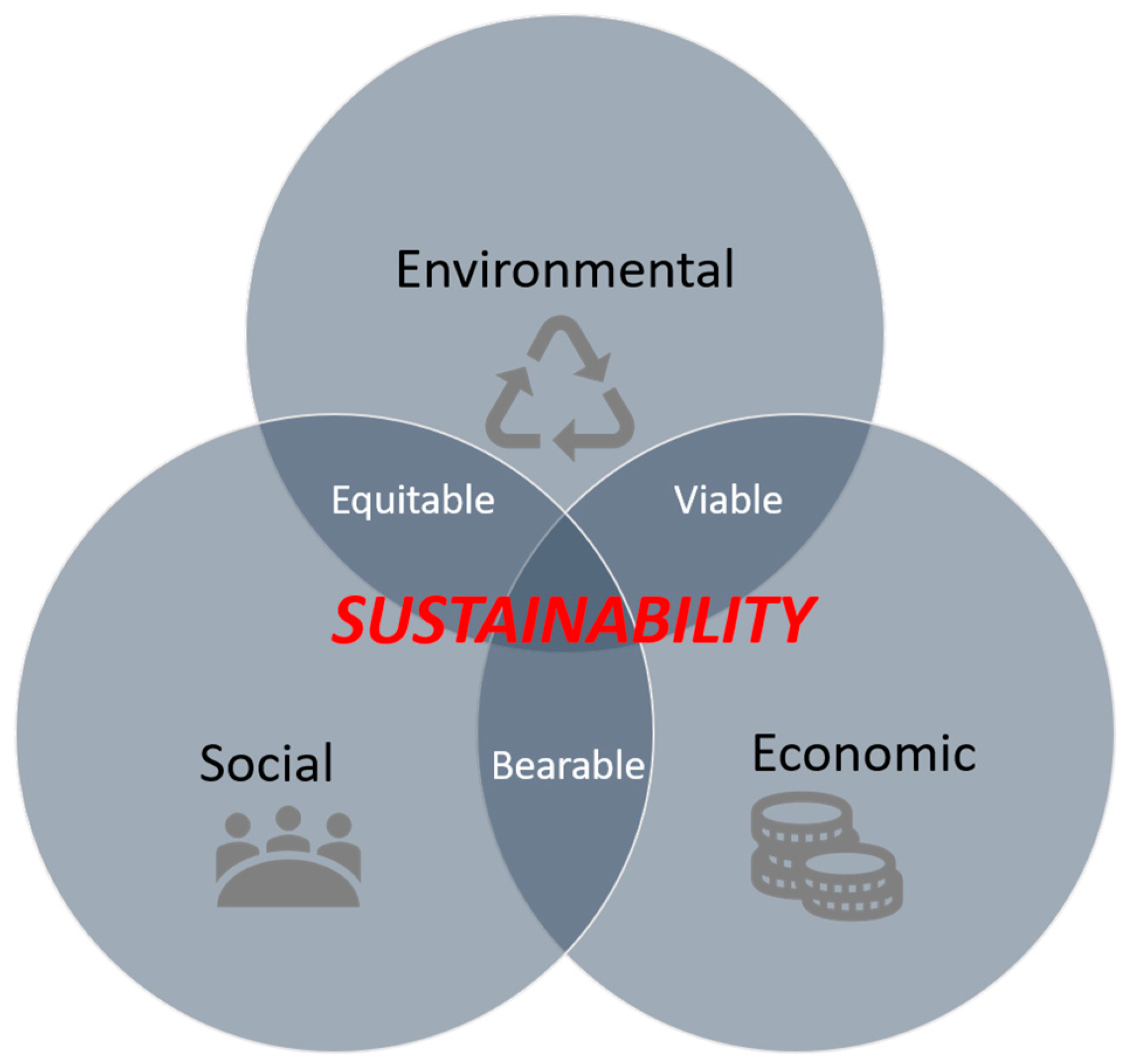
2.1. The Sustainability Paradigm: A New Vision of Mobility

The World Commission on Environment and Development first introduced the concept of “sustainable development” in the report Our Common Future, also known as Brundtland Report, which consists in “…a development that meets the needs of the present without compromising the ability of future generations to meet their own needs” [6].
In an all-round vision referring to sustainability, three pillars can be considered related to economic, social, and environmental aspects (Figure 1). According to the European Commission, the strategies to promote sustainable development cannot fail to consider the economic, social, and environmental effects of all urban policies in a coordinated way [7]. Thus, in the long term, to ensure economic growth, social cohesion, and environmental protection, it is necessary to promote an integrated land-use and transport system through adequate urban policies and planning approaches in the vision of safety, social equity, and environmental issues.
The governance of a territory constitutes a multifaceted activity in relation to the principles of sustainable urban mobility due to both technical and political conflicts. In this regard, several approaches can be considered as effective tools and concrete solutions: gathering transport accessibility [8,9,10], adequate infrastructure [11], adaptive services and intelligent transport systems [12,13], integrated urban transport and planning tools [14,15], and urban requalification processes and indicators [16,17].
In the vision of the sustainability concept, the Sustainable Urban Mobility Plans (SUMPs) can be considered a tool able to integrate the long-term goals for transport users at all mobility levels by proposing planning practices with a human-centered approach, considering their needs and highlighting the importance of citizens’ quality of life [18]. The sustainability paradigm leads to a new vision of mobility moving from a traditional approach to Sustainable Transport Planning [19], which sees (1) the integration between transport and territory, (2) the concept of accessibility with respect to the mobility one, (3) the promotion of active and non-motorized trips, (4) the street considered as a public space, (5) the use of multicriteria analyses in order to consider aspects that cannot be directly monetized (i.e., safety, environmental pollution), (6) the role of shared mobility as opposed to car ownership, (7) the demand management and urban requalification without increasing the supply, (8) development of low speed areas, and (9) transport users integration.
Following these assumptions, the next sections will focus on the role of national and international policies in defining sustainable mobility targets and of urban regeneration processes as tools to implement safer and climate friendlier mobility in cities.

2.2. Systematic Urban Policies and Planning Approaches for Climate-Friendly Mobility in Cities: The Current Perspective

Urban areas form a complex and dynamic system in which many factors interrelate in many ways. What is the role of road safety and climate friendliness within this system? And how does that role relate with other components? Several key issues, referring to both spatial and transport planning can be listed, such as the transport network, the urban structure, traffic management practices, planning and transport policies, parking strategies, employment, social policies, the image of the city, and environmental concerns [20].
Multifunctional land-use policies play a crucial role in the long-term perspective that is needed to change current trends and move towards more sustainable and climate friendly cities. These policies should include the densification of urban land uses, the regeneration of former industrial areas and derelict land, and the concentration of development around public transit corridors. The location of specialized types of workspaces, regionally oriented services and cultural facilities, and large traffic generating services, close to important public transit interchanges, should also be part of the land-use planning policies.
In the United States, the New Urbanism movement has become the concept around which a lot of new urban plans were developed to curb automobile dependence. New Urbanism is a movement that incorporates the need to expose car-dependent assumption in town planning rules and fashions; instead, it is oriented around a transit system and attempts to create walking environments through denser, more mixed land use, house fronting streets with garages behind, and other design qualities. Therefore, New Urbanism is discovering how planning and design can better incorporate less automobile-dependent land use, particularly in the layout of streets and the orientation of buildings to the street, as well as in density and mix activities [21,22]. Additionally, many other planning approaches, like transit-oriented development [23], car free development [24], multimodal development, growth management [25], and smart growth [26] are pursuing similar goals too.
More recent examples of people and climate-oriented transport solutions are the fully equipped multi-modal “mobility stations” in the city centers of Hamburg, Munich, and Vienna, which are viewed as lighthouse projects to foster sustainable transport in everyday use. All of them have been promoted by local public transit authorities and their service providers. In the City of Hamburg, the HVV (Hamburger Verkehrsverbund, i.e., Hamburg Transport Association) switch mobility hubs have been implemented at a larger number of stations, initiated at metroline crossing stations. Electric vehicle carsharing services are integrated into this concept to turn public transit supply into a complete alternative to privately operated automobiles.
For Munich, first research results demonstrate the positive effects on mode choice and travel behavior [27]. The importance of choosing appropriate locations for these mobility hubs has been underlined.
More years of experience with the mobility station approach to foster sustainable travel modes have been documented for the City of Vienna [28]. These experiences were used to develop a comprehensive set of guidelines, and their application in the urban development area of “Donaufeld”. The concept is also systematically supported by the Austrian “AustriaTech” [29].
The examples of mobility hubs described above have proven to raise interest in alternatives to driving alone. However, they cannot be the appropriate solution for every location; especially smaller cities and towns may not find the resources to implement such hubs. However, there are other options as well that might even better fit in a residential area and can be set up with a smaller budget. The guidelines developed for cities and municipalities in North Rhine-Westphalia, Germany, by the “Zukunftsnetz Mobilität NRW” [30] are targeted to help local authorities to decide which form to apply, and this network may also deliver customized support and consulting on integrated planning and mobility management approaches.
A meaningful urban regeneration process can be considered for the city of Paris, which is one of the promoting cities of the C40 Cities network. Under the push of Mayor Anne Hidalgo, the City has launched a series of actions [31,32] in agreement with those outlined by the 2030 Agenda and to achieve the objectives of decarbonization and reduction of climate-altering emissions established by the 2015 Conference of the Parties (COP), which was held in the French capital. By reviewing its Climate Action Plan, Paris is working to reduce energy use and promote renewable energy generation [33], preparing the city for the long-term effects of climate changes. The Paris Climate Action Plan was first developed in 2007 in response to heat waves, floods, and water scarcity caused by climate change. With energy consumption forecast to rise and temperature levels steadily rising, the city has renewed its commitment with new measures to promote renewable energy generation and reduce energy use, creating a climate resilient and livable city for Parisians [32,34].
The Paris Climate Action Plan was renewed in 2012 and covers six main themes: low-energy urban planning [5], energy efficiency and affordable housing, the service industry, low carbon transport [35], sustainable consumption, and the first city adaptation strategy [32,33,36].
The project presented by Paris to achieve these goals seeks to give a solution to the challenges of the urban climate and is divided into ten sectors, ranging from solid waste management to transport, and also introduces innovative aspects such as the link between climate change and social equity. The topic of social justice is quite new in the field of adaptation strategies, but it shows the importance of involving disadvantaged and marginalized social classes to achieve the goals related to sustainable development [37]. By promoting this philosophy, the municipality of Paris wants to foster participatory policies that involve investors, development organizations, the Mayors of the municipalities of the wider area, and, more generally, those who have joined the Covenant of Mayors [35]. Among the most relevant actions that the Hidalgo administration is carrying out to pursue these objectives, a series of initiatives can be found to combat air pollution and promote mobility, with particular attention to the elimination of diesel vehicles and the promotion of bike and car sharing [35]. Another issue the municipality is trying to address is poor air quality [36]. This phenomenon is mainly related to the use of motor vehicles, especially diesel-powered vehicles, responsible for 40% of fine dust emissions. To remedy this situation, the city has launched a series of rigorous measures to anticipate the abandonment of diesel vehicles and promote low-carbon mobility [36]. In particular, the municipality has proposed an ambitious mix of public policy initiatives and investments in alternative modes of mobility [34,36]. These specific measures include the improvement of the pedestrian network, the promotion of the use of electric vehicles, and the progressive abandonment of polluting vehicles. In addition to this, Paris provides a car sharing service that offers a convenient and cost-effective alternative for residents who face increased congestion and car ownership costs. The all-electric car sharing program (Autolib) also provides a path to overcome market barriers for electric vehicles, making potential consumers more comfortable using electric vehicles.
Thanks to integrated policies regarding existing buildings, such as the creation of one million square meters of green roofs, the municipality achieved the reduction of 25% of carbon emissions in 2020.
However, with the goal to sum them up, what are the key urban policies and planning approaches today that can really help in lowering carbon emissions in cities, while increasing safety for all users?
Most likely, the so-called avoid–shift–improve (A-S-I) approach can be seen as a comprehensive approach to foster more sustainable and climate friendly mobility patterns [37]: avoid–allow citizens to move without using the car; shift–try to shift the movements to other transport modes, e.g., public transit and cycling; and improve–if using the car, try to improve new climate friendly technologies, like clean fuels, use of technologies, more efficient use through carpooling, etc.
To foster this approach, some urban policies can be considered as the basis to overcome automobile dependence and increase the safety and environmental friendliness of our mobility patterns:
  • Traffic calming: to slow car traffic and create more urban, human environments better suited to other transportation modes.
  • Quality transit, bicycling, and walking: to provide efficient transport alternatives to the car through an integrated strategy promoting sustainability.
  • Urban villages and growth management: to create multimodal centres with mixed, dense land uses that reduce the need for motorized travel and that are linked to high-quality public transit. Density clearly emerged as a major determinant of automobile use. Many studies confirmed the exponential relationship between transit ridership and density (both employment density and residential density) [38,39,40,41]. An urban village approach to urban development recognizes the need to bring more community values into new and redeveloping parts of every area of the city and tries to bring greater walkability.
  • Better taxing transportation and use of new shared mobility services: to cover external mobility costs. Bieler and Sutter explored them for Germany for the year 2017 and calculated EUR 149 billion, thereof EUR 141 billion (94.5%) attributed to road transport [42], while for the European Union, the EU Commission published the results of their recent studies on data in 2014, and on the development of policies in 2019 [43]. Both national and international policy levels have to a) phase-out and eventually terminate subsidies for fossil fuels, and b) urgently (better) allow for an internalization of external costs, as finally has been agreed upon for the EU legislation on road pricing after decades of controversies [44,45,46].
  • Mobility hubs: To further reduce automobile dependency, complete alternatives to driving alone need to be developed. Authorities responsible for spatial planning, as well as those for transportation planning and transport policy, may consider measures that allow for comfortable transfers from one transport (sub-)mode to another. Multi-modal travel is defined as using different modes of transport throughout the week, whereas the term inter-modal travel is restricted to trips with a change of mode such as Park-and-Ride.
Mobility hubs have been systematically developed for a long time in public transit to provide access between rail and bus services and other forms of transit, and in the meantime, this concept comprises a larger variety of means of travel and the methods to combine them. These range from very basic concepts of Bike-and-Ride or Park-and-Ride lots [47] to well-equipped “mobility stations” possibly including metro, tram, bus, car-sharing, taxi, ride-pooling, carpooling, bike-sharing, and e-scooter rental.

2.3. From Urban Policies to Local Actions

It is interesting to observe how the policies described in the previous paragraphs have consequences on the urban management system. The goal to create a safer and climate friendly urban environment can bring local bodies to develop local and punctual actions aimed at increasing urban quality.
In this field, it is possible to link the policies related to mobility and transport systems to the ones related to urban regeneration processes.
If the Goal 11 of the United Nation Agenda 2030 for Sustainable Development is considered, it is possible to observe that safety is one of the key points to create a sustainable settlement [48,49]. Therefore, it is viable to say that the recovery of abandoned parts of cities could be an occasion to operate in urban areas and to increase the quality of life.
It is also possible to say that International Agendas can inspire local actions in territory by influencing the normative framework in which public administrations can move.
This aspect is easily demonstrated. It is enough to think of the impact that the COP 21 held in Paris in 2015 had on the policies of the city in the following years and that are previously described.
This section of the work is dedicated to the analysis of the link between the urban policies introduced before and some case studies aimed at recovery parts of the consolidate city with the goal to foster a more sustainable lifestyle by reducing the dependence on cars and promoting walkability.
An example of this important link is an urban regeneration process that is happening in Paris, and it can be considered an implementation at neighborhood scale of the sustainable mobility policies described in the previous section.
As part of the Reinventing City Challenge promoted by the C40 Cities network, Paris formed the Collective for Climate, which bolstered the birth of a new zero-emission district. The project, winner of the competition, aims to reduce 85% of its total emissions through a myriad of innovative approaches and will go beyond the carbon neutrality goal thanks to the creation of a Carbon Fund [50].
The project involves the production of geothermal and photovoltaic energy on site for the benefit of the entire district. Emissions will also be significantly reduced thanks to the choice of building materials, with 80% of the superstructure to be built in wood or stone; and 100% of the facades must be composed of materials of biological origin such as terracotta bricks and hemp.
The Collective for Climate strongly calls for a localized and responsible economy, paying close attention to the origin of the materials and equipment used for the project. Eighty percent of the building materials will therefore come from the surroundings of Paris.
The project restores greenery, encourages low-carbon mobility, and includes activities that will promote sustainable lifestyles, such as zero-waste food courts and coffee, and a new “Grand Hall” dedicated to a flea market [50].
The project for a zero-emission district, which aims to achieve carbon neutrality through the creation of the first zero-carbon district in Paris, is divided into some key components. In this area, there will be a mixture of actions that will involve buildings, redeveloped with modern techniques and materials to reduce their impact on the energy budget of the city, and open spaces that will be flexible and able to adapt to people’s needs. These open areas will be developed as oases grounded on natural vegetation and water-based solutions, which will provide ecosystem services.
The most important action that will allow the achievement of both a climate friendly and people-oriented district is the transformation of the area from a car oriented and poor in green space area to an open space with over 7000 square meters of vegetation. An important aspect is that this strategy is supervised by a vision aimed at reducing the use of individual cars through the creation of a decentralized city in which people are connected to the essential services and economic activities. This project feature will help in reducing carbon emissions due to transport and will foster more sustainable lifestyles.

3. A Methodology to Assess the Effects of Urban Regeneration through a People-and-Climate-Oriented Mobility

It was previously demonstrated that small and diffuse local actions can change neighborhoods’ aspects and quality. They can also be the tool through which urban policies derived from international networks and agendas are implemented at local scale.
Therefore, this article aims to propose a methodology to assess how these interventions can foster and support the sustainability goals and, namely, the strategic targets aimed at increasing road safety and reducing carbon emissions.
Chapter 3 proposes an Italian case study in which an abandoned site was redeveloped, giving attention to aspects related to permeability and walkability. Within this case study, a GIS-based methodology to assess the effects of urban regeneration is proposed, which allows us to understand the route of urban policies in achieving a people-oriented and climate friendly mobility.

3.1. Ex-Ante and Ex-Post Assessment towards Urban Regeneration and Pedestrian Accessibility

In the previous paragraphs, it was explained how the goal of achieving carbon neutrality can be a driver for urban regeneration policies at district scale whose effects have externalities both on the physical matrix and of the socioeconomic structure of the city. The implementation of urban regeneration interventions is closely linked to the development of the network of public areas and mobility spaces. This feature is at the basis of analysis and assessment of greater urban accessibility scenarios thanks to infrastructure implementation and redevelopment in the frame of urban regeneration policies. In fact, urban regeneration cannot be separated from a proper analysis and plan of the level of accessibility to public services, and more generally from a redevelopment of the public space for mobility connected to the areas subject to regeneration.
To better investigate this issue, Section 3 presents the case study of a neighborhood in Brescia, a medium sized city in the North of Italy, where thanks to the urban regeneration of a brownfield area, soft mobility was enhanced increasing urban accessibility.
To study the effects of the urban regeneration process on neighborhoods and resident people, a network analysis was developed. This methodology allowed an understanding of the externalities linked to the creation of an open area inside the studied district and the definition of how the implementation of pedestrian and cycle paths contribute to foster accessibility to services and promoting a healthier lifestyle grounded on walkability.
The applied methodology was characterized by different phases and developed in a GIS environment. The first phase was represented by the ex-ante analysis, and it concerned the study of the existing soft mobility network. Within the ex-ante analysis, the first step was the definition of the cognitive framework, which had the aim to investigate the existing networks, services, and shops and the distribution of residents. Then, it was possible to develop a network analysis, which allowed the linking of these elements to each other. This analysis allowed the performance of an exploration of the maximum distance in which people can reach services using the soft mobility networks in a defined time. The GIS based methodology adopts the network analyst tool to map isochrones [51]. Input data derive from the topographical geodatabase of the Brescia municipality and from the geocoding of municipal data about inhabitants.
Once the ex-ante analysis is developed, the second phase can start, and it is composed of the ex-post analysis. It concerns the implementation of the soft mobility layer and the services layer, adding the new paths and lanes and economic activities created within the urban regeneration process. Then, it is possible to redo the network analysis.
The comparison of the ex-post situation and the ex-ante one allowed an understanding of how accessibility changes in the site thanks to the urban regeneration process. Namely, it is possible to see the dependency of accessibility from two different factors: the distribution of services and the capillarity of the soft mobility network. The variation of these two parameters contributed to create a more walkable space and a more livable area for residents.
Once the data about resident people are georeferenced thanks to the geocoding operation and the network analysis is developed, it is feasible to assess the effects of the urban transformation on the walkability of the site.
Here are proposed some indicators that deal with the features of the network of soft mobility path, the number of services that are possible to reach on foot, and the distribution of people that live within a walkable area.
Thanks to the modeling of the cycle and pedestrian network, it is possible to define the “catchment area”, or the portion of territory that is included in a considered distance.
Thanks to the theory of organic urban planning, walkable distance is considered a distance of one kilometer, which corresponds, on average, to a walkable time of fifteen minutes [52].
Once the catchment area is defined, it is possible to select the data of resident people that are located inside that boundary. This allows the assessment of the number of inhabitants reached by the paths developed within the urban regeneration process.
The proposed methodology can be easily replicated to other contexts considering data about soft mobility paths and statistical distribution of resident people related to that different scenario.

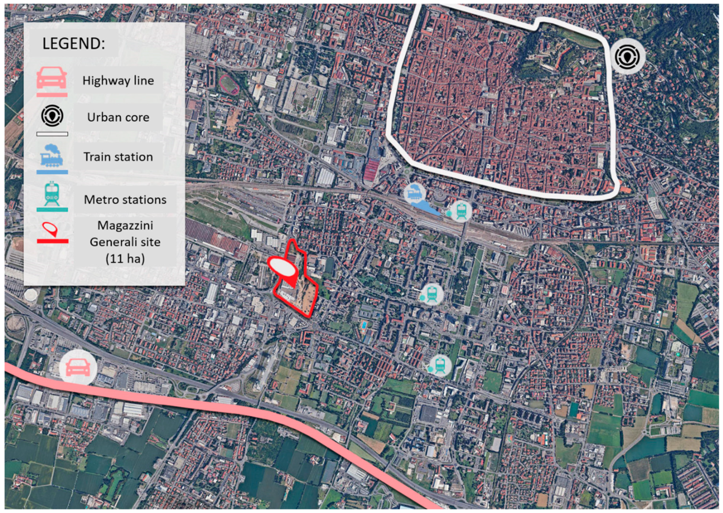
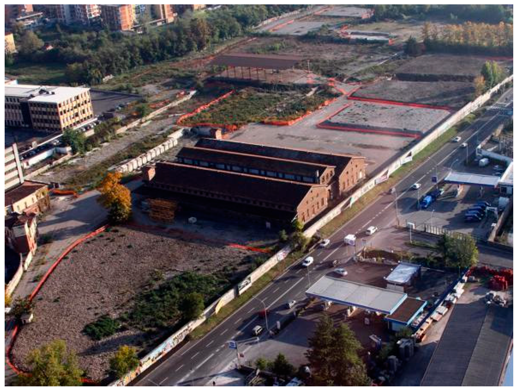
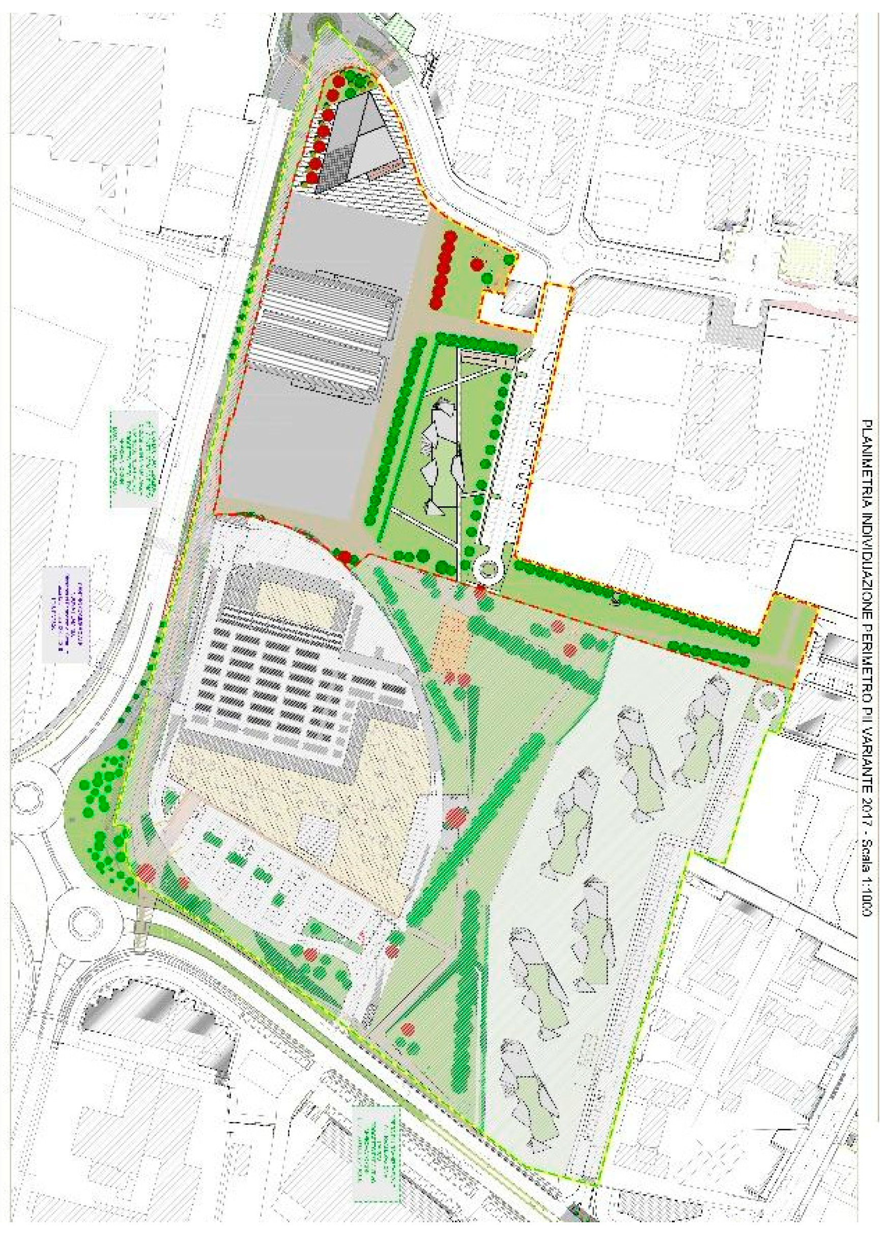
3.2. Redevelopment of an Abandoned Area—The Case of “Magazzini Generali” in Brescia

The Magazzini Generali (Warehouses) site is a former industrial area located in the Don Bosco district in the southern area of Brescia. Thanks to its past vocation, it was built close to strategic infrastructure such as the railway, the train and underground station, and important vehicular lanes, and from the analysis of satellite picture (Figure 2), it is possible to understand that the site is located between very dense residential areas, too. One feature that characterizes the site is that there is the presence of important ancient industrial buildings that today are constrained by the superintendence of fine arts and, in the past, they were used to store cheese.
The site was employed until the 1990s, and then it was abandoned, creating an 11-hectare void inside one of the densest districts of the city. The creation of this urban void was particularly disadvantageous for people living in that area. The Magazzini Generali is surrounded by walls, and they create an impervious site that does not allow people to cross it to reach important services, such as shops and markets or religious services located on the boundary of the walls. This feature forced people to travel for a longer distance to reach services. This aspect discourages users from walking and encourages the use of private vehicles, as the distance that separates them from the attractive centers becomes incompatible with their needs.
Thanks to its strategic position inside the consolidated city and the dimensions of the area, the municipality decided to start a process to redevelop the site. This strategy found the interest of private stakeholders that decided to join the municipality in this process. Namely, a consortium was created that included a real estate agency and a store brand.
The redevelopment project was grounded on fostering the permeability of the site, and the new area was opened in 2019. The walls have been demolished, and the previous warehouses, except for the ones constrained by the superintendence, have been replaced by a supermarket, shops, and services.
Today, the site hosts a big green area in which there is a park for children, and there are cycle and pedestrian paths, too. On the eastern boundary, there is an area that will host new residential houses, and in the northern part, it is still feasible to see the ancient warehouses, which are protected by the superintendence and create an interesting pole of industrial archaeology (see Figure 3, Figure 4 and Figure 5). In Figure 5, it is clearly visible how the perimeter of the site was surrounded by walls that did not allow people to cross the site. The urban regeneration projects highlighted in Figure 5 shows how the intervention was grounded on fostering the permeability of the area through the creation of walkable connections.

3.3. Results of Ex-Ante and Ex-Post Scenarios Comparison

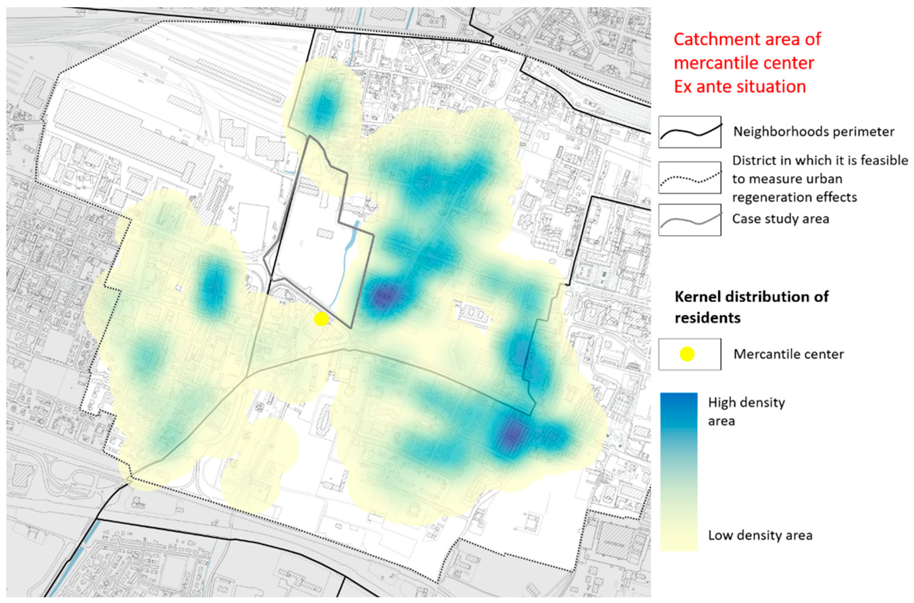
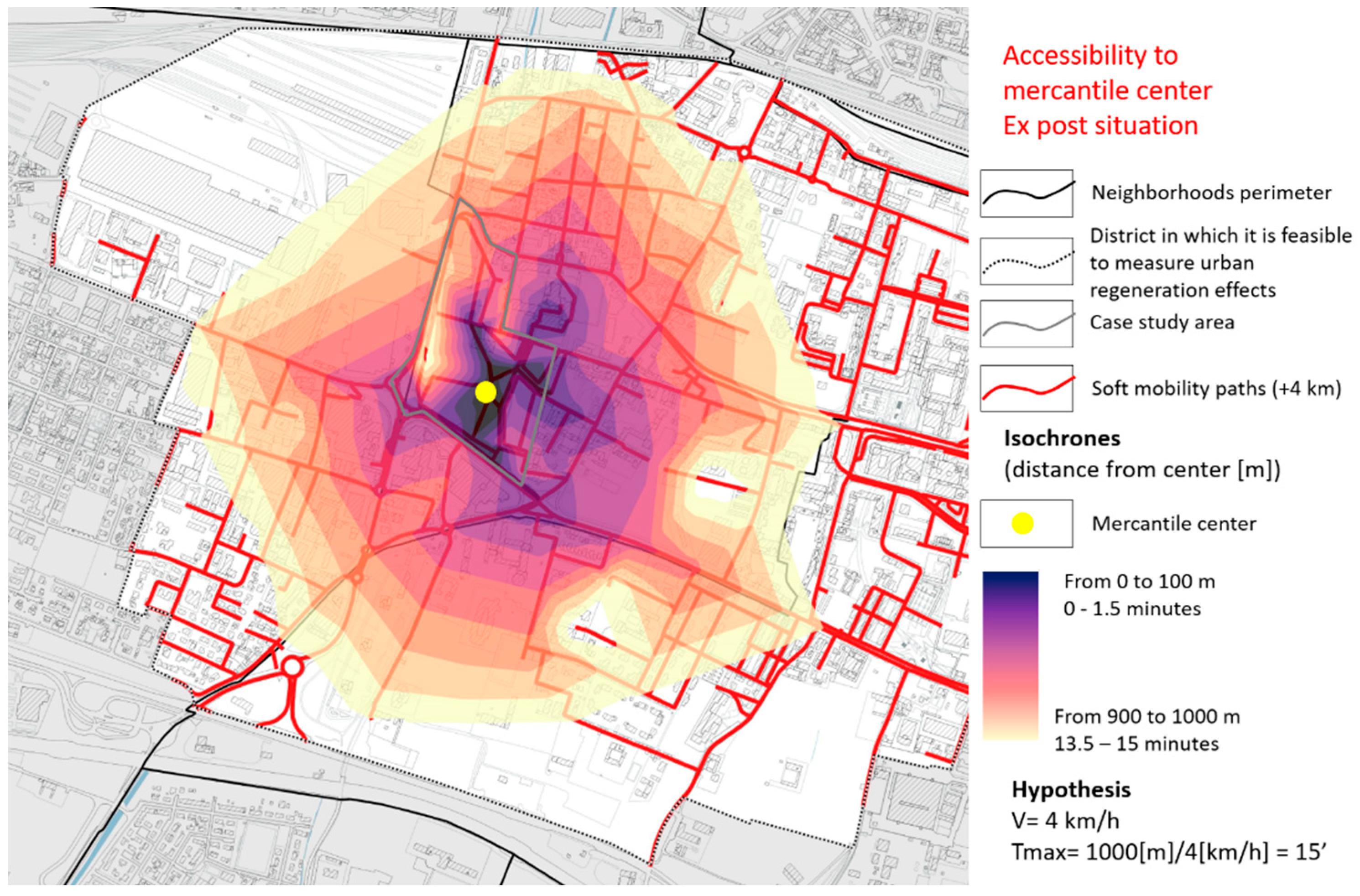
3.3.1. Accessibility Analysis of the Mercantile Life Center

The first network analysis was made on the area of the mercantile life center from which it emerged, such as the opening of the fronts, the creation of numerous cycle and pedestrian paths, and the positioning of the main services within the area that was previously forbidden to public use, which has led to an increase in the number of possible users who can access the identified service on foot.
The pedestrian accessibility to the center of mercantile life was analyzed both in the ex-ante and the ex-post situation. The previous step concerns the modelling of the situation before the implementation of the urban regeneration actions. In this scenario (Figure 6), the Ex Magazzini Generali site is an obstacle to walkability. In the first maps, isochrones are represented that have their center in the previous shopping area. The color of the isochrones is darker where the distance is lower and is lighter where the distance is higher. The shops are in the middle of the dark purple isochrone.
As can be seen from the first map, the residential portion of the city located in the upper part is isolated from the shops and services placed in the opposite site of the former industrial area. The only existing networks to reach the market are the vehicular lanes displaced on the boundaries of the site, which means that people are forced to use private cars. Another aspect that is highlighted by the network analysis is the distribution of residents that live in a walkable distance of 1000 m from the mercantile center. Figure 7 represents the statistical distribution of resident people, and it is the result of a kernel distribution analysis. The yellow areas are the sites in which the distribution of residents is lower, while the blue sites are the places in which there is a higher possibility to find people. From this map, it is possible to understand that the northern part of the district is excluded from the shops area. These data confirm the thesis that there is a high-density residential area not linked to the analyzed core. If residents’ distribution is considered, it is viable to understand that in the ex-ante scenario, the fabrics surrounding the mercantile center are characterized by a low density, while the high-density sites are located far away. Once the ex-ante network analysis is completed, it is possible to implement the layers of infrastructure, services, and resident people considering the ex post situation and define how the situation changes thanks to the urban regeneration process. Namely, thanks to urban infrastructure works related to the regeneration process, 4 km of pedestrian and cycle paths have been created.
The ex-post network analysis (Figure 8) shows how the barycenter of the isochrones moves in a position closer to residential sites located in the northern and eastern boundaries of the Ex Magazzini Generali site thanks to three main aspects: the displacement of the mercantile center in a new position, the creation of pedestrian paths that link residential areas and the shops, and the demolition of the existing walls that in the past created an important obstacle to the creation of soft mobility networks.
The main result is that in the new scenario, the isochrones can cover a bigger residential area. This feature is also confirmed by the map shown in Figure 9. In fact, if kernel statistical distribution of residents is considered, it is feasible to understand that in the ex-post scenario, residents are closer to shops and services than in the ex-ante situation.
The results of these analyses are also supported by the analyzed data reported in Table 1, which considers the correlation between the distance from the mercantile center and the number of inhabitants that live within that distance both in the ex-ante and the ex-post scenarios.
In the end it is possible to say that thanks to the urban regeneration process, people who live in a walkable distance of one km from shops and services is increased from 8220 to 8512. The effect is even higher if people living in a closer distance are considered. For example, if a distance of 300 m is considered, the number of resident people increases from 57 to 129 inhabitants, while the number of residents within a distance of 500 m moved from 849 to 1343 inhabitants.
If the area covered by a walking distance of one kilometer is analyzed, it is possible to notice an intriguing aspect: in the case of the ex-ante assessment, the catchment area covered a surface of 156 hectares, while in the ex-post scenario, the covered surface is 153 ha. What has really changed is not the quantity, but the quality of the land. In the ex-ante situation, only a small percentage of the catchment area covered high residential neighborhoods, and a lot of surface was over abandoned former industrial sites or rural land. In the ex-post situation, the central position that the mercantile center assumed after the intervention allowed to better fit the distribution of high-density residential areas.

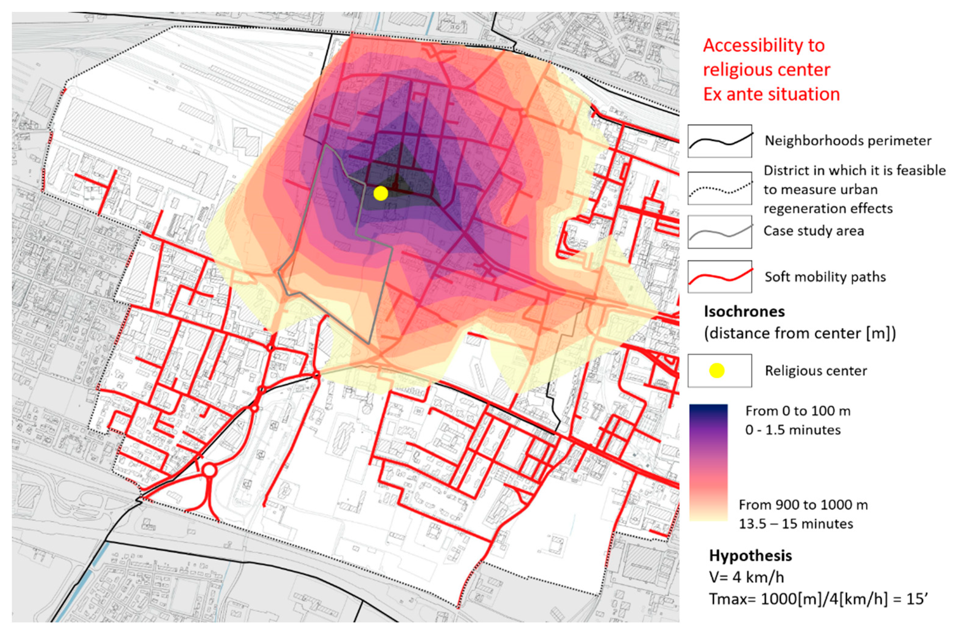
3.3.2. Accessibility Analysis of the Center of Religious Life

Another example is given by the analysis of accessibility to the center of religious life, which, in addition to the special religious buildings, also contains meeting places such as bars and various sports facilities. Additionally, in this case, the analysis was carried out with reference to the ex-ante situation, in which the area of the Magazzini Generali constitutes an obstacle to achieve the religious center from people coming from the residential areas located on the southern and eastern boundaries of the site. Then, the ex-post network analysis is developed considering the new infrastructure created within the urban regeneration process.
In this case, it is feasible to see how the creation of the paths allows the facilitation of access to the site and the expansion of the area covered by the range of action, too (see Figure 10 and Figure 11).
For the case study of the accessibility to the religious center, the extension of the catchment area in the ex-ante scenario was 114 hectares, and in the ex-post scenario, it is 124 hectares. This increase is due to the growth in pedestrian permeability of the Magazzini Generali site, which lets people cross the site to reach the services. Residential areas located under the southern boundary of the site were previously unable to reach the services in the northern part in a reasonable time and this aspect forced them to use cars. Now the situation has changed, and thanks to the urban operation, it is feasible to walk across the site and reduce car dependency to reach shops and services.

4. Discussion: Fostering Walkability at Neighborhood Scale to Achieve Sustainable Mobility Targets

All theories, policies, and plans described in the previous subsections, and that emerged from the Magazzini Generali case study analysis, have many points in common with the “organic urban planning” vision elaborated in Italy at the end of the 1960s [53], and afterwards developed at the University of Brescia in the research studies coordinated by Busi [54]. From the beginning of the 1990s, Busi and his researchers have developed the theme of “living and walking in the city”: the juxtaposition of these two verbs denotes the vast and qualifying dimension that the city can claim when the “life” of its citizens is enhanced by the fact that they can walk, pleasurably and safely, in it.
The organic urban planning vision is based on the analysis of technical implications arising from the satisfaction of individual and social human needs. Starting from the features of the technical plants of a city (houses, social services, shops, markets, schools, hospitals, green areas, open spaces, streets, infrastructure facilities, etc.) the organic planning approach has the objective to satisfy the specific needs of the citizen as an individual or as a social being, through the best use of these facilities. In this model, the neighborhood urban unit plays a crucial role, and it is based on the premise that the system of mobility for excellence, for moving into the neighborhood, is walking.
If the Magazzini Generali case study is analyzed under the organic urban planning point of view, it is viable to observe that the areas with the best access time were decentralized with respect to the site considered and thatthe area of the Magazzini Generali constituted an obstacle for people who live in the northern area and wanted to walk to the center of merchant life.
Analyzing the spatial distribution of the possible users able to access on foot, covering a maximum distance of 1000 m, it was feasible to observe that the whole northern area was uncovered.
Comparing the maps obtained with the ex-post scenario in which the area of the Magazzini Generali is usable, it emerged that the community center is moved to a position that is closer to the high-density residential areas and the soft mobility network has been significantly enhanced; it can be seen that the range of action that covers the site is more homogeneous, and also possible users are more equally distributed. It can be noted that the north area that was previously discovered, following the urban transformation falls largely within the range of action. This allowed the increase of the number of possible users; moreover, the realization of numerous cycle and pedestrian paths inserted in a quality environment, also from the aesthetic and architectural point of view, allows the development of a soft mobility network between neighborhoods.
From this case study, it emerged that promoting walkability is one of the best tools in the hands of public administration to develop sustainable mobility policies that are both people oriented and climate friendly.
This is possible if, and only if, soft mobility takes place in conditions of security and safety. The places for pedestrians have to be designed and realized in close connection with public transit, since the pedestrian is its main user. This is the reason for which transport planning must go hand in hand with the urban choices, providing lines where citizens live, work, and spend their free time.
Nowadays, these approaches may be pursued mainly through urban regeneration interventions: urban regeneration today can, and must, be the opportunity to rethink soft mobility in our cities with a view to promoting a widespread accessibility to activities. This idea found fertile ground in Paris, where, as it was explained before, the participation in international networks (as the C40 Cities) or joining international conferences and agendas (as the one defined by the COP) gave the opportunity to the municipality to develop urban regeneration strategies aimed at the recovery of abandoned areas fostering walkability and promoting climate oriented interventions. The same process happened in Milan, another city that joined the C40 Cities networks and thanks to ideas, strategies, and funds shared with the other municipalities has developed urban regeneration interventions financed by the Reinventing Cities Challenge, which are giving the possibility to the administration to implement the comprehensive policies into concrete interventions at district scale [55]. Namely, the financed projects in Milan are focused on redeveloping former and abandoned railway stations.
These are only some examples among the wide panorama of urban actions aimed at increasing pedestrian safety and walkable accessibility inside the consolidated city at the neighborhood level. Other case studies that may be considered are the “Superblock model” introduced in Spanish cities such as Barcelona or Vitoria-Gasteiz and applied also in Pontevedra downtown and in Wien (Austria) (with the so-called “Supergrätzl” approach), or the Italian “Isola Ambientale”, in which streets for cars are separated from residential and walkable areas.
Another holistic vision to be mentioned in this context is called “Tomorrow’s Cities”, developed by the German Environment Agency, and an experimental application of this vision with the focus on measures to improve walking and cycling is the Berlin Mobility Lab Flaniermeile Friedrichstrasse [56,57]. Other noteworthy experiences involve the city of Turin, in Italy, where the Torino City Lab operates at different levels to test innovative mobility solutions [58,59].

5. Conclusions

The paper presented, from an urban planning perspective, some urban policies and planning approaches, available in the literature, for the implementation of safer and more climate friendly mobility patterns in cities, by also referring to a case study focusing on the role of urban regeneration to improve pedestrian accessibility at the neighborhood level.
Current car-based travel patterns are unsustainable. It is clear that “…the imperative is not only to switch to more sustainable forms of transport (which include public transit) but for a large proportion of our travel to be moved to the most sustainable forms: walking and cycling…” [60].
In the last 20 years, many cities adopted a clear tendency towards backing away from traffic priority in a drift towards increasingly differentiating speed limits in urban traffic. Developments in recent years have shown that traffic calming by using physical measures and design of street space having regard to road aesthetics will result in lower speed, increased safety and security, and improved urban environment, which provide the basis for a higher quality of life. However, simply slowing down the traffic through traffic calming measures is not enough to reach the environmental qualities and climate friendliness that are needed in a sustainable city. It is necessary to co-ordinate traffic and mobility planning with urban planning, seeing the city as a complex and interrelated entity.
But today the integration of elements of analysis, evaluation, and accessibility planning still finds only few applications in general urban planning tools. In very recent times, however, they are considered within the SUMP, a tool which lends itself to be the most suitable tool to address, if properly coordinated with general planning, elements of safe and climate friendly mobility planning. The SUMPs tool was introduced, replacing the traditional Urban Mobility Plans, together with the European documentation in the last decade, which was first mentioned in the Urban Mobility Action Plan of 2009 and in the White Paper of 2011 [1], to be explained later with specific guidelines in 2014 [15,61]. A specific analysis, like the one proposed for the urban regeneration of the ex Magazzini Generali site, can form a knowledge base in which an accessibility focused SUMP can take root.
In this vision, ex-ante and ex-post pedestrian and cycling accessibility measures, like the one performed for the case study presented in this paper, could provide a framework in the planning practice for decision-making support within the context of the Sustainable Urban Mobility Plans.
In other words, and as many authors have highlighted, nowadays the shift from mobility-oriented to accessibility-based transport planning is the key towards sustainable and energy efficient transport planning for all users [62,63,64,65,66,67]. Thus, as it emerged from the urban regeneration case study presented in this paper, this shift can also be encouraged and fostered through urban regeneration processes of the existing urban fabric: at the scale of the neighborhood, the redevelopment of public spaces for mobility can aim at connecting places that play a central role, to favor cycling and pedestrian mobility and to discourage crossing traffic with traffic calming interventions. This is also particularly true looking at the COVID-19 pandemic period, where several cities are re-inventing and re-adapting their neighborhoods to foster 15-min accessibility [68,69,70].
Starting from these assumptions, further research may focus on the comparison between different case studies both at national and European level, to analyze the effectiveness of several urban policies and planning approaches, like the one presented for Brescia, both through qualitative judgement and quantitative indicators.

Author Contributions

The authors jointly designed and contributed to the paper. Conceptualization: S.R., M.T., M.D.S., and V.T.; data curation: S.R., F.B., V.T., and M.D.S.; formal analysis: F.B.; investigation, S.R., F.B., V.T., and M.D.S.; validation: S.R., D.V., and M.T.; methodology: S.R. and M.T.; supervision: M.T. and D.V.; writing—original draft: S.R., F.B., M.D.S., and V.T.; writing—review and editing: S.R., M.T., and V.T.; funding acquisition: M.T. All authors have read and agreed to the published version of the manuscript.

Funding

DICATAM—Università degli Studi di Brescia.

Institutional Review Board Statement

Not applicable.

Informed Consent Statement

Not applicable.

Data Availability Statement

Data is contained within the article.

Conflicts of Interest

The authors declare no conflict of interest.

Disclaimer

Data and statements presented in this article are the sole responsibility of the authors and do not necessarily reflect the views of any of the institutions named herein.

References

  1. European Commission. White Paper: Roadmap to a Single European Transport Area—Towards a Competitive and Resource Efficient Transport System; European Commission: Brussels, Belgium, 2011. [Google Scholar]
  2. Bloomberg, M. City Century | Foreign Affairs. Available online: https://www.foreignaffairs.com/articles/2015-08-18/city-century (accessed on 1 December 2020).
  3. Williams, K. Spatial Planning, Urban Form and Sustainable Transport; Ashgate Publishing Ltd.: London, UK, 2005. [Google Scholar]
  4. Tira, M.; Pezzagno, M. Town and Infrastructure Planning for Safety and Urban Quality. In Proceedings of the XXIII International Conference on Living and Walking in Cities (LWC 2017), Brescia, Italy, 15–16 June 2017; CRC Press: Boca Raton, FL, USA. [Google Scholar]
  5. Tira, M.; Tiboni, M.; Rossetti, S.; De Robertis, M. Smart planning to enhance nonmotorised and safe mobility in today’s cities. In Green Energy and Technology; Springer: Berlin/Heidelberg, Germany, 2018; Volume PartF12, pp. 201–214. [Google Scholar] [CrossRef]
  6. Brundtland, G.H. Our Common Future: The World Commission on Environment and Development; Oxford University Press: Oxford, UK, 1987. [Google Scholar]
  7. European Commission. A Sustainable Europe for a Better World: A European Union Strategy for Sustainable Development; Commission of the European Communities: Brussels, Belgium, 2001. [Google Scholar]
  8. Caggiani, L.; Camporeale, R.; Dimitrijević, B.; Vidović, M. An approach to modeling bike-sharing systems based on spatial equity concept. Transp. Res. Procedia 2020, 45, 185–192. [Google Scholar] [CrossRef]
  9. Curtis, C.; Scheurer, J. Planning for Public Transport Accessibility: An International Sourcebook; Routledge: London, UK, 2016. [Google Scholar]
  10. Carpentieri, G.; Guida, C.; Masoumi, H.E. Multimodal Accessibility to Primary Health Services for the Elderly: A Case Study of Naples, Italy. Sustainability 2020, 12, 781. [Google Scholar] [CrossRef] [Green Version]
  11. Campisi, T.; Acampa, G.; Marino, G.; Tesoriere, G. Cycling Master Plans in Italy: The I-BIM Feasibility Tool for Cost and Safety Assessments. Sustainability 2020, 12, 4723. [Google Scholar] [CrossRef]
  12. Torrisi, V.; Ignaccolo, M.; Inturri, G. Innovative Transport Systems to Promote Sustainable Mobility: Developing the Model Architecture of a Traffic Control and Supervisor System. In Proceedings of the International Conference on Computational Science and Its Applications, Melbourne, VIC, Australia, 2–5 May 2018; Springer: Cham, Switzerland, 2018; pp. 622–638. [Google Scholar] [CrossRef]
  13. Bandeira, J.M.; Tafidis, P.; Macedo, E.; Teixeira, J.; Bahmankhah, B.; Guarnaccia, C.; Coelho, M.C. Exploring the Potential of Web Based Information of Business Popularity for Supporting Sustainable Traffic Management. Transp. Telecommun. J. 2020, 21, 47–60. [Google Scholar] [CrossRef] [Green Version]
  14. Rossetti, S. Planning for Accessibility and Safety; Maggioli: Santarcangelo di Romagna, Italy, 2020. [Google Scholar]
  15. Torrisi, V.; Garau, C.; Ignaccolo, M.; Inturri, G. Sustainable Urban Mobility Plans. Key Concepts and a Critical Revision on SUMPs Guidelines. In Proceedings of the International Conference on Computational Science and Its Applications, Cagliari, Italy, 1–4 July 2020; Springer: Cham, Switzerland; pp. 613–628. [Google Scholar]
  16. Garau, C.; Pavan, V.M. Evaluating urban quality: Indicators and assessment tools for smart sustainable cities. Sustainability 2018, 10, 575. [Google Scholar] [CrossRef] [Green Version]
  17. Tiboni, M.; Botticini, F.; Sousa, S.; Jesus-Silva, N. A Systematic Review for Urban Regeneration Effects Analysis in Urban Cores. Sustainability 2020, 12, 9296. [Google Scholar] [CrossRef]
  18. European Commission. 2nd Edition of Guidelines for Developing and Implementing a Sustainable Urban Mobility Plan. Available online: https://www.eltis.org/mobility-plans/sump-guidelines (accessed on 1 December 2020).
  19. Banister, D. The sustainable mobility paradigm. Transp. Policy 2008, 15, 73–80. [Google Scholar] [CrossRef]
  20. Tira, M. Safety of pedestrians and cyclists in Europe: The DUMAS approach. In Sustainable Transport; Tolley, R., Ed.; Woodhead Publishing: Cambridge, UK, 2003. [Google Scholar]
  21. Katz, P. The New Urbanism: Toward an Architecture of Community; McGraw-Hill: Washington, DC, USA, 1993. [Google Scholar]
  22. Congress for the New Urbanism. Charter of The New Urbanism; McGraw-Hill: Washington, DC, USA, 1999. [Google Scholar]
  23. Calthorpe, P. The Next American Metropolis: Ecology, Community, and the American Dream; Princeton Architectural Press: New York, NY, USA, 1993. [Google Scholar]
  24. Crawford, J.H. Carfree Cities; International Books: New York, NY, USA, 2020. [Google Scholar]
  25. Porter, D. Profiles in Growth Management; The Urban Land Institute: Washington, DC, USA, 1996. [Google Scholar]
  26. Smart Growth Network. Getting to Smart Growth: 100 Policies for Implementation; Smart Growth Netw.: Washington DC, USA, 2002. [Google Scholar]
  27. Miramontes, M.; Pfertner, M.; Rayaprolu, H.S.; Schreiner, M.; Wulfhorst, G. Impacts of a multimodal mobility service on travel behavior and preferences: User insights from Munich’s first Mobility Station. Transportation 2017, 44, 1325–1342. [Google Scholar] [CrossRef]
  28. Zientek, J.; Illek, G.; Posch, K.H. Leitfaden Mobilitätsstationen. Die Umsetzung von Mobilitätsstationen in Stadtentwicklungsgebieten am Beispiel Zielgebiet Donaufeld, Wien. Available online: https://docplayer.org/113340724-Leitfaden-mobilitaetsstationen.html (accessed on 1 December 2018).
  29. Mosshammer, L.; Spiegel, N. Sharing Mobility–Gemeinsam Mobil. Österreichs Sharing Community und die Potenziale für Städte und Gemeinden. Available online: https://www.austriatech.at/en/sharing-and-new-forms-of-mobility/ (accessed on 1 December 2020).
  30. Zukunftsnetz Mobilität NRW. Handbuch Mobilstationen Nordrhein-Westfalen. Available online: https://www.zukunftsnetz-mobilitaet.nrw.de/ (accessed on 1 December 2020).
  31. C40 Cities. Paris Adaptation Strategy Secures Crucial Resources. 2016. Available online: https://www.c40.org/case_studies/cities100-paris-adaptation-strategy-secures-crucial-resources (accessed on 8 November 2020).
  32. C40, & NYC Mayor’s Office of Sustainability. Defining Carbon Neutrality for Cities & Managing Residual Emissions, 2019. Available online: https://c40-production-images.s3.amazonaws.com/researches/images/76_Carbon_neutrality_guidance_for_cities_20190422.original.pdf?1555946416 (accessed on 1 April 2019).
  33. C40 Cities. Paris Renewed Plan Advances Climate Action. 2016. Available online: https://www.c40.org/case_studies/cities100-paris-renewed-plan-advances-climate-action (accessed on 8 November 2020).
  34. C40 Cities. Paris Greening District Heating Cuts Emissions. 2016. Available online: https://www.c40.org/case_studies/cities100-paris-greening-district-heating-cuts-emissions (accessed on 8 November 2020).
  35. C40 Cities. C40, Good Practice Guides Paris Autolib. 2016. Available online: https://www.c40.org/case_studies/c40-good-practice-guides-paris-autolib (accessed on 8 November 2020).
  36. C40 Cities. Paris Transport Policy Curbs Air Pollution. 2016. Available online: https://www.c40.org/case_studies/cities100-paris-transport-policy-curbs-air-pollution (accessed on 8 November 2020).
  37. Bakker, S.; Zuidgeest, M.; De Coninck, H.; Huizenga, C. Transport, Development and Climate Change Mitigation: Towards an Integrated Approach. Transp. Rev. 2014, 34, 335–355. [Google Scholar] [CrossRef]
  38. Kenworthy, J. Trends in low carbon transport and urban development in 33 cities, 1995/1996 to 2005/2006. In Low Carbon Cities; Lehmann, S., Ed.; Routledge: London, UK, 2015. [Google Scholar]
  39. Cervero, R.; Guerra, E. Urban Densities and Transit: A Multi-Dimensional Perspective. UC Berkeley: Center for Future Urban Transport: A Volvo Center of Excellence. Available online: https://escholarship.org/uc/item/3mb598qr (accessed on 1 December 2020).
  40. Cervero, R.; Landis, J. Suburbanisation of jobs and the journey to work: A submarket analysis of commuting in the San Francisco Bay area. J. Adv. Transp. 1992, 26, 275–297. [Google Scholar] [CrossRef]
  41. Alexander, I. Employment dispersal in metropolitan areas: Equitable and energy saving? In Proceedings of the 51st ANZAAS Conference, Architecture and Planning Section, Brisbane, Australia, 12–16 May 1980. [Google Scholar]
  42. Available online: https://www.infras.ch/de/projekte/deutschland-149-milliarden-euro-externen-verkehrskosten/ (accessed on 8 November 2020).
  43. EC. Handbook on the External Costs of Transport; European Commission: Brussels, Belgium, 2019. [Google Scholar]
  44. Köder, L.; Burger, A. Umweltschädliche Subventionen in Deutschland 2016. Available online: https://www.umweltbundesamt.de/publikationen/umweltschaedliche-subventionen-in-deutschland-2016 (accessed on 1 December 2020).
  45. Matthey, A.; Bünger, B. Methodological Convention 3.0 for the Assessment of Environmental Costs Cost Rates Version 02/2019. Available online: https://www.umweltbundesamt.de/publikationen/methodological-convention-30-for-the-assessment-of-Environmental-Costs (accessed on 1 December 2020).
  46. BMVI. Informal Video Conference of EU Ministers of Transport. Available online: https://www.bmvi.de/SharedDocs/EN/Articles/K/EU-Council-Presidency/conference-eu-transport-ministers-08-12-2020.html (accessed on 8 December 2020).
  47. Heinitz, F. Vertiefende Analyse der Vor-und Nachteile von P+R. Teilbericht 3 des Forschungsprojekts “Recht und Rechtsanwendung als Treiber oder Hemmnis Gesellschaftlicher, ökologisch Relevanter Innovationen–Untersucht am Beispiel des Mobilitätsrechts–RechtSInnMobil” (UBA-Texte 214/2020). Available online: https://www.umweltbundesamt.de/publikationen/analyse-park-and-ride (accessed on 1 December 2020).
  48. United Nations. The Millennium Development Goals Report; United Nations: New York, NY, USA, 2015; Volume 72, ISBN 978-92-1-101320-7. [Google Scholar]
  49. United Nations. Sustainable Development Goals: Sustainable Development Knowledge Platform. Sustainabledevelopment.Un.Org, p. 1. Available online: https://sustainabledevelopment.un.org/?menu=1300 (accessed on 1 December 2020).
  50. C40 Cities. Porte de Montreuil, Winning Project. Available online: https://www.c40reinventingcities.org/en/sites/winning-projects/porte-de-montreuil-1303.html (accessed on 8 November 2020).
  51. Rossetti, S.; Tiboni, M.; Vetturi, D.; Zazzi, M.; Caselli, B. Measuring Pedestrian Accessibility to Public Transport in Urban Areas: A GIS-based Discretisation Approach. Eur. Transp. 2020, 76, 1825–3997. [Google Scholar]
  52. Busi, R.; Bresciani, C. Urbanistica Tecnica; Aracne Editrice, Ed.; Ermes. Servizi Editoriali Integrati: Roma, Italy, 2006. [Google Scholar]
  53. Columbo, V. La Ricerca Urbanistica; Organica Urbanistica; Giuffrè: Milano, Italy, 1965. [Google Scholar]
  54. Busi, R. For a Safer City. A Friendlier City. And a More Beautiful City. TeMA-J. Land Use Mobil. Environ. 2010, 2. [Google Scholar] [CrossRef]
  55. C40 Cities. Reinventing Cities Milan-Announcement of the Finalists | News & Events | Reinventing Cities. 2020. Available online: https://www.c40reinventingcities.org/en/events/reinventing-cities-milan-announcement-of-the-finalists-1427.html (accessed on 6 January 2021).
  56. Lehmkühler, S.; Büttner, A.; Kiso, C.; Schaefer, M.D. The Berlin mobility lab Flaniermeile Friedrichstrasse. Exploring cooperation towards tomorrow’s cities. TeMA-J. Land Use Mobil. Environ. 2020, 13, 125–148. [Google Scholar] [CrossRef]
  57. Umweltbundesamt. Tomorrow’s Cities Environmentally Friendly Mobility, Low Noise, Green Spaces, Compact Housing and Mixed-Use Districts. Available online: https://www.umweltbundesamt.de/publikationen/tomorrows-cities (accessed on 1 December 2020).
  58. De Marco, A.; Mangano, G.; Zenezini, G.; Cagliano, A.C.; Perboli, G.; Rosano, M.; Musso, S. Business Modeling of a City Logistics ICT Platform. In Proceedings of the International Computer Software and Applications Conference, Hong Kong, China, 28–30 September 2004; pp. 783–789. [Google Scholar]
  59. Perboli, G.; Brotcorne, L.; Bruni, M.E.; Rosano, M. A new model for Last-Mile Delivery and Satellite Depots management: The impact of the on-demand economy. Transp. Res. Part E Logist. Transp. Rev. 2021, 145, 102184. [Google Scholar] [CrossRef]
  60. Tolley, R. Sustainable Transport. Planning for Walking and Cycling in Urban Environments; Woodhead Publishing: Sawston, UK, 2003. [Google Scholar]
  61. European Commission Guidelines. Developing and Implementing a Sustainable Urban Mobility Plan; European Commission Directorate for Mobility and Transport: Brussels, Belgium, 2014. [Google Scholar]
  62. Bauer, U.; Hertel, M.; Buchmann, L.; Frehn, M.; Spott, M. UBA Texte 177/2020: Let’s Go! Framework for a National Walking Strategy (International Version); Institut für Urbanistik: Berlin, Germany, 2020. [Google Scholar]
  63. Handy, S. Accessibility vs Mobility. Enhancing Strategies for Addressing Automobile Dependence in the U.S. Institute for Transportation Studies; UC Davies: Leeds, UK, 2002. [Google Scholar]
  64. Gargiulo, C.; Zucaro, F.; Gaglione, F. A Set of Variables for the Elderly Accessibility in Urban Areas. TeMA-J. Land Use. Mobil. Environ. 2018, 2, 53–66. [Google Scholar]
  65. Bonotti, R.; Rossetti, S.; Tiboni, M.; Tira, M. Analysing Space-Time Accessibility Towards the Implementation of the Light Rail System: The Case Study of Brescia. Plan. Pract. Res. 2015, 30, 424–442. [Google Scholar] [CrossRef]
  66. Zazzi, M.; Ventura, P.; Caselli, B.; Carra, M. GIS-based monitoring and evaluation system as an urban planning tool to enhance the quality of pedestrian mobility in Parma. In Town and Infrastructure Planning for Safety and Urban Quality, Proceedings of the XXIII International Conference on Living and Walking in Cities, London, UK, 15–16 June 2017; Tira, M., Pezzagno, M., Eds.; CRC Press, Taylor and Francis Group: Boca Raton, FL, USA, 2017; pp. 87–94. [Google Scholar]
  67. Rossetti, S.; Tiboni, M. In Field Assessment of Safety, Security, Comfort and Accessibility of Bus Stops: A Planning Perspective. Eur. Transp./Trasporti Europei 2020, 8, 1825–3997. [Google Scholar]
  68. Cerema. Aménagements Provisoires pour les Piétons: Tester pour Aménager Durablement. Available online: https://www.cerema.fr/fr/centre-ressources/boutique/amenagements-provisoires-pietons-tester-amenager-durablement (accessed on 1 December 2020).
  69. Comune di Milano. Strade Aperte. Strategie, Azioni e Strumenti per la Ciclabilità e la Pedonalità, a Garanzia delle Misure di Distanziamento negli Spostamenti Urbani e per una Mobilità Sostenibile; Comune di Milano: Milano, Italy, 2020. [Google Scholar]
  70. NACTO-National Association of City Transportation Officials. Streets for Pandemic Response & Recovery; National Association of City Transportation Official: New York, NY, USA, 2020. [Google Scholar]
Figure 1. The Venn diagram of sustainable development. Source: author elaboration based on UN definition of “sustainability”.
Sustainability 13 01778 g001
Figure 2. The “Magazzini Generali” site. Source: Author’s elaboration.
Sustainability 13 01778 g002
Figure 3. The Magazzini Generali site in the second half of the XXth Century.
Sustainability 13 01778 g003
Figure 4. The Magazzini Generali site before the urban regeneration process; it is feasible to recognize the constrained warehouses and the walls surrounding the site.
Sustainability 13 01778 g004
Figure 5. The project to enhance the site and the walkable permeability of the area through the creation of soft mobility paths and open public areas.
Sustainability 13 01778 g005
Figure 6. Cycle and pedestrian paths and their sphere of influence (max distance = 1000 m) in the case study neighborhood; ex ante situation.
Sustainability 13 01778 g006
Figure 7. Statistic distribution of people that can access shops and services walking up to fifteen minutes; ex ante situation.
Sustainability 13 01778 g007
Figure 8. Cycle and pedestrian paths and their sphere of influence (max distance = 1000 m) in the case study neighborhood; ex post situation.
Sustainability 13 01778 g008
Figure 9. Statistic distribution of people that can access shops and services walking up to fifteen minutes; ex post situation.
Sustainability 13 01778 g009
Figure 10. Cycle and pedestrian paths and their sphere of influence (max distance = 1000 m) in the case study neighborhood; Accessibility to the religious center—ex ante situation.
Sustainability 13 01778 g010
Figure 11. Cycle and pedestrian paths and their sphere of influence (max distance = 1000 m) in the case study neighborhood; Accessibility to the religious center—ex post situation.
Sustainability 13 01778 g011
Table 1. Inhabitants within walking distance [m] from the mercantile centers in the ex-ante and in the ex-post scenario.
Walking DistaNCE [M]Ex Ante Scenario [N. Reached Inhabitants]Ex Post Scenario [N. Reached Inhabitants]Increase from Ex-Ante to Ex-Post [%]
30057129+126.31%
400415753+81.44%
5008491343+58.18%
60015602222+42.43%
70025133138+24.87%
80036044366+21.14%
90059406006+1.1%
100082208512+3.55%
Publisher’s Note: MDPI stays neutral with regard to jurisdictional claims in published maps and institutional affiliations.

