Article

Evaluating Urban Green Public Spaces: The Case Study of Krasnodar Region Cities, Russia

Urban Planning Department, National Research Moscow State University of Civil Engineering, Yaroslavskoe sh. 26, 129337 Moscow, Russia
*
Author to whom correspondence should be addressed.
Sustainability 2021, 13(24), 14059; https://doi.org/10.3390/su132414059
Submission received: 26 October 2021 / Revised: 6 December 2021 / Accepted: 8 December 2021 / Published: 20 December 2021

Abstract

:
The 21st century challenges, in particular those of climate change, population growth, air pollution and the COVID-19 pandemic global health crisis, demand greater emphasis on infrastructure facilities capable of keeping pace with population needs in well-being, health and economic prosperity. Green infrastructure aimed to intensify ecological processes in built-up areas and deliver vital ecosystem services is of a key significance for Russia, one of the most urbanized countries in the world. The article is dedicated to the issue of providing cities sustainability through creating a basic element of the urban green infrastructure—a public green network—by incorporating and linking a variety of already existing urban environmental components, both spatial and linear, such as natural areas, squares, parks, streets, boulevards, embankments and others. The territory of the case study is Krasnodar region located in the southwestern part of the North Caucasus, the warmest region of Russia characterized by highly varied urban areas. The authors propose the multiple criteria method for evaluating the existing GreenPS and creating a GreenPS framework for six cities located in Krasnodar region both on the southern seaward part and on the northern steppe part. This approach is focused on the sustainable development of the cities, adaptation to climate change and the prevention of local risks with respect to the preservation of ecosystem functions and cultural heritage. The methodology includes three stages: investigating and evaluating the present state of the existing urban GreenPS; defining sustainability potential; and the submission of master plan proposals for the improvement and further development and management of the GreenPS network implementing nature-based solutions. In addition, it follows seven main integral criteria, namely, Accessibility, Density, Sufficiency, Continuity, Diversity, Value and Clean and Sanitary, illustrated by ray diagrams. The results of the study show good potential for construction in Krasnodar region cities of an efficient GreenPS network integrating ecological and social city components. The flexibility of the method proposed makes it replicable for any other city aimed at creating a GreenPS network in sustainable, climate-change-adapted cities.

1. Introduction

Nowadays, local living environments are perceived as key instruments to ensure health and wellbeing to people. The COVID-19 pandemic has demonstrated the value of urban street life for physical and mental respite, restricting access to green spaces, particularly social ones, related to recreational and cultural activities and has worsened essentially both the quality of life and economy. The green city concept based on multifunctional land use responds to today’s most important environmental, economic and social challenges, such as climate change adaptation and mitigation, biodiversity protection and social cohesion, which increased in the pandemic [1,2,3]. Therefore, in Russia and across the world, planning a green flexible city is in a special focus due to the associated benefits that positively impact people’s health, comfort and safety [4,5,6,7].
Today, urban green spatial planning advances from creating landscaped areas with social and aesthetic value to the consideration urban green as a kind of modern urban multifunctional infrastructure which supports both social, economic and ecological processes and also allows cities to become more polycentric [8,9]. The possibility to locate housing, work and leisure along and around ample landscaped public space which allows free transit movement without congestion and with guaranteed quality of healthy well-being surely remains relevant also after the pandemic and for future generations [10,11,12,13].
The concept of green infrastructure as a planned network of both natural and semi-natural areas interconnected with other urban environmental features designed and managed with the aim to favor urban ecology has attracted special attention of both academic research and planning practice specialists in Russia [4,10,14,15,16] and across the world [1,2,7,17,18,19,20]. The results show a new green spaces trend and a significant increase in the city greenness over the last 10 years [3]. Used as a spatial planning instrument, green network provides not only environmental advantages, which include climate change mitigation and adaptation [1,20,21] but additionally deliver a wide range of social benefits [19,22,23,24] and economic services [15,25], which positively impact on people’s health, well-being and prosperity. Particular research considers planning streets as public spaces and interconnecting elements between city parks, natural green areas and other city attractions [26,27,28].
Although, there is a considerable literature on the definition, approaches and implementation strategies of green spaces according to climate, natural resources, structure and other local context characteristics of the city, i.e., in the areas with high aridity or high population density, where every tree is of a great value [6,18,29], or in the cold area [2,4,16,21] or in other nature conditions [5,7,11,30], the approaches to the definition of green spaces and developing are different. For Russia, for example, the term urban green place involves urban land covered with vegetation, generally open and accessible for people, and its development is in the competence of the municipality, while for Europe and the United States, the term urban green place can refer also to the privately opened greened spaces with or without public access.
In Russia, the practice of city beautification in general, and greening in particular, was of key importance for the quality of everyday life during the Soviet period beginning from the 1920s. Since then, the restored and developed cities have abundant urban public space either green or suitable to create green public spaces. Nowadays, this process is slowed, and the problem of car-oriented streets and abandoned park areas with poor access conditions are widely diffused [9,10,14,15].
This study deals with the topic just of urban green public space(s) which makes it relevant mostly for Russian cities. Not all urban green areas are public and not all urban public spaces are green. A simple diagram in the Figure 1 illustrates their relationship: The overlap of two circles represents the topic of our research.
This study focuses on the topic just of urban green public space (s), which, in addition to ecological services, also deliver social and economic services (Figure 1). Furthermore, the term urban green public space (GreenPS) will be used to describe the concept of the study. The concept of the study consists of proposing the methodology for evaluating already existing urban green public spaces aimed at developing integrated continuous urban GreenSP network (Figure 2) and thus improving the sustainable impact of urban GreenPS on the city. This methodology intends to join social, economy and ecological components of urban environment both in the land use planning and policymaking processes.
Furthermore, the term urban green public space (GreenPS) will be used. Focusing primarily on planning a sustainable green public space city network, the paper proposes the research method to evaluate the current state and development potential of already existing urban green public places in the cases of six cities located in different areas of the Krasnodar region (Figure 2).
The following section contains the description of the study area, as well as the explanation why this area was chosen for the study. It also introduces the methodology and research materials used. Section 3 presents the results, their interpretation and analysis. Section 4 deals with the discussion and Section 5 concludes the analysis.

2. Materials and Methods
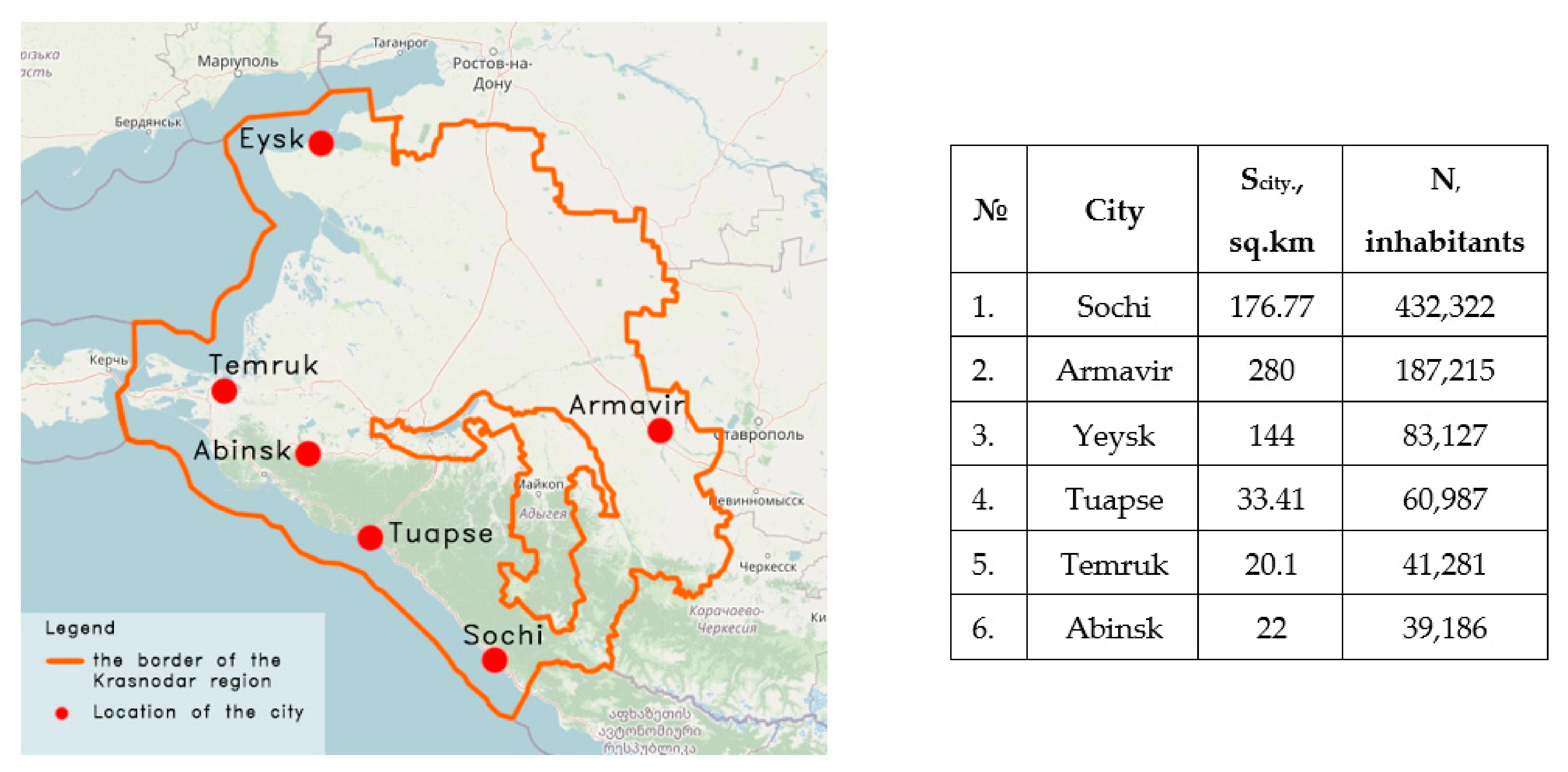
2.1. Study Area

Six cities and towns in Krasnodar region were chosen as the study area. The area of Krasnodar Region is 76 thousand sq m, and the population is 5.6 million people. The population density is 75.3 people/sq km (Figure 2).
Administratively, the Krasnodar region is divided into 38 regions and 15 cities of regional significance with populations from 100 up to nearly 800 thousand people, further subdivided into 11 towns of urban-type and rural settlements and districts. Located in the southwestern part of the North Caucasus, it is the third most populated and the warmest federal subject of Russia.
The Kuban River splits the region into two distinct parts: The northern part of the region is a steppe zone with continental climate features, whereas the southern part is the western extremity of the Caucasus range. Lying between the Sea of Azov and the Black Sea, it shares the patterns of Mediterranean climate and, in the southeast, of subtropical climate. The plains, crossed by the Kuban and other rivers flowing to the Sea of Azov, form two-thirds of the region. The Azov coast is lined with widespread salt marshes and lagoons. Western Caucasus occupies the southern third of the region and reaches 3790 m at Mount Psysh, falling in height westward as they run parallel to the Black Sea. The lower slopes of the mountains are covered by the forest; higher, there are conifers and alpine meadows. In general, the comfortable climate conditions of the region contribute to the development of tourism and agriculture. Petroleum and natural gas are exploited on the Taman Peninsula and in the north. Novorossiysk and Tuapse are major oil-exporting ports. The Krasnodar region’s coastline is famous by unique combination of beautiful seascapes, forested mountain ranges and the most fortunate climate conditions in Russia. It supports important economic sectors such as fishery, food processing shipping and, most of all, tourism, which is one of the main bases of the regional economy.
Geography, climate and other factors that make Krasnodar Region unique and so important for Russia pose also additional challenges in terms of sustainable planning and land use. Today, population and economic activities growth as well as climate change visibly threaten to deteriorate the environmental quality of Krasnodar region cities.
For these reasons, the cities of Krasnodar Region were chosen as a case study for the development of a GreenPS framework based on sustainable management approach, namely Sochi, Armavir, Tuapce, Yeysk, Temruk and Abinsk.
All of them are the centers of social, economic and tourist life of the Region with populations from approximately 500 to 50 thousand people, which significantly increases in tourist seaward locations in summer months. For the purpose of the study, the cities were chosen in a way to be divided in 3 groups, each consisting of 2 cities with common climate features and quite different populations and areas:
  • The first group: Sochi (176.77 square kilometers; 432,322 inhabitants) and Tuapse (33.41 sq km.; 60,987 inhabitants), situated along the Black Sea coast, both with humid subtropical climates;
  • The second group: Yeysk (144 square kilometers; 83,127 inhabitants) and Temryuk (20.1 sq km.; 41,281 inhabitants), situated on the shore of the Sea of Azov, both with humid continental climates;
  • The third group: Armavir (280 square kilometers; 187,215 inhabitants) and Abinsk (22 square kilometers; 39,186 inhabitants), located at Kuban-Azov lowland, with moderately continental climate features.

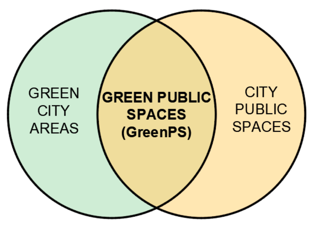
2.2. Methodological Approach for the Development of Urban GreenPS Network
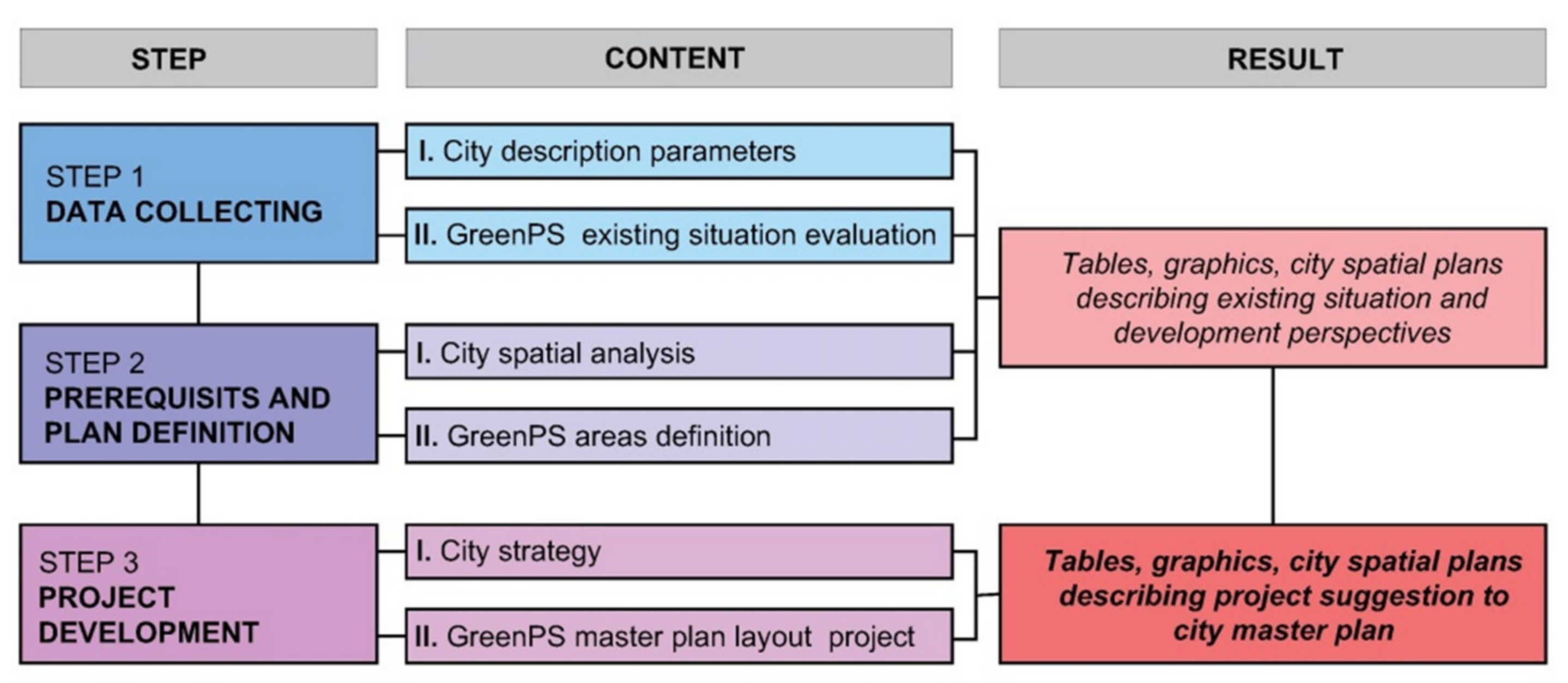
Every country and every municipality has the right and the autonomy to choose how to use, plan, create and develop the green city. Despite the nowadays widespread practice of urban greening, it still remains a very difficult task for the municipality, and especially urban planners, to design and effectively manage urban GreenPS in a sustainable way due to both variety and complexity of the concepts of green (blue, flexible, smart, etc.) cities.
The COVID-19 pandemic has revealed how much a city’s life relies on access to GreenPS, which also have social and economic value in addition to those generally recognized ecology and health related values.
The major part of Russian cities built and developed during the Soviet Union period has a unique heritage of abundant urban space that allows for the creation a GreenPS network quite capable to provide sustainable development of the city, including the aspects of climate change mitigation and adaptation. However, there is still no defined methodology to guide its evaluation, implementation and planning.
Public green space in this study consists of greened freely approached urban places which are generally open for public access and use, located at dedicated lands not related to residential and/or administrative zones and saturated with social and economic functions such as parkland (whether it is a large multi-purpose or a neighborhood, or theme, or pocket one), squares and beaches. Unlike the urban green network, the term urban green public spaces network involves only publicly accessible green spaces linked by green public linear corridors such as greened roads (including pavement), streets, riverbanks and others (Figure 3), thus providing its efficiency.
Based on these definitions, the territories integrated in the green public network should include two types of spatial components that differ mainly in shape: variable non-linear spaces and linear corridors (Table 1). In line, both with Russian legislation and the concept of the study, privately owned urban green places are not taken into consideration as possible space components of urban public GreenPS network because they do not satisfy the requirements of green public places.
Ecological, integrative, accessible and continuous public green networks address the goals of sustainable development of the city as well as the population’s wellbeing and future challenges such as climate change mitigation and adaptation.
Table 2 presents the overview of the GreenPS network’s impact on the city sustainability, composed on the basis of examination and evaluation of reliable international research studies [3,18,31,32,33].
Today, worldwide, the evaluation of the city’s territorial space development mainly uses mathematic models of collecting and analyzing both qualitative and quantitative data [7,13,17,19,31,32,34,35]. In Russia, a lack of quantitative data makes qualitative data analysis more usual [5,9,11,15,16,21,36]. The proposed methodology integrates both practices for the assessment of the present impact of urban GreenPS on the city in terms of sustainability.
The methodological process consisted of three following phases (Figure 4):
  • Data collecting;
  • Defining the urban GreenPS network structure;
  • Project suggestions to the city master plan.
The first phase included collecting the requisite data referring to the selected parameters, describing present situation and evaluating the indices and integral indicators. The selected parameters were organized in two groups (Figure 5):
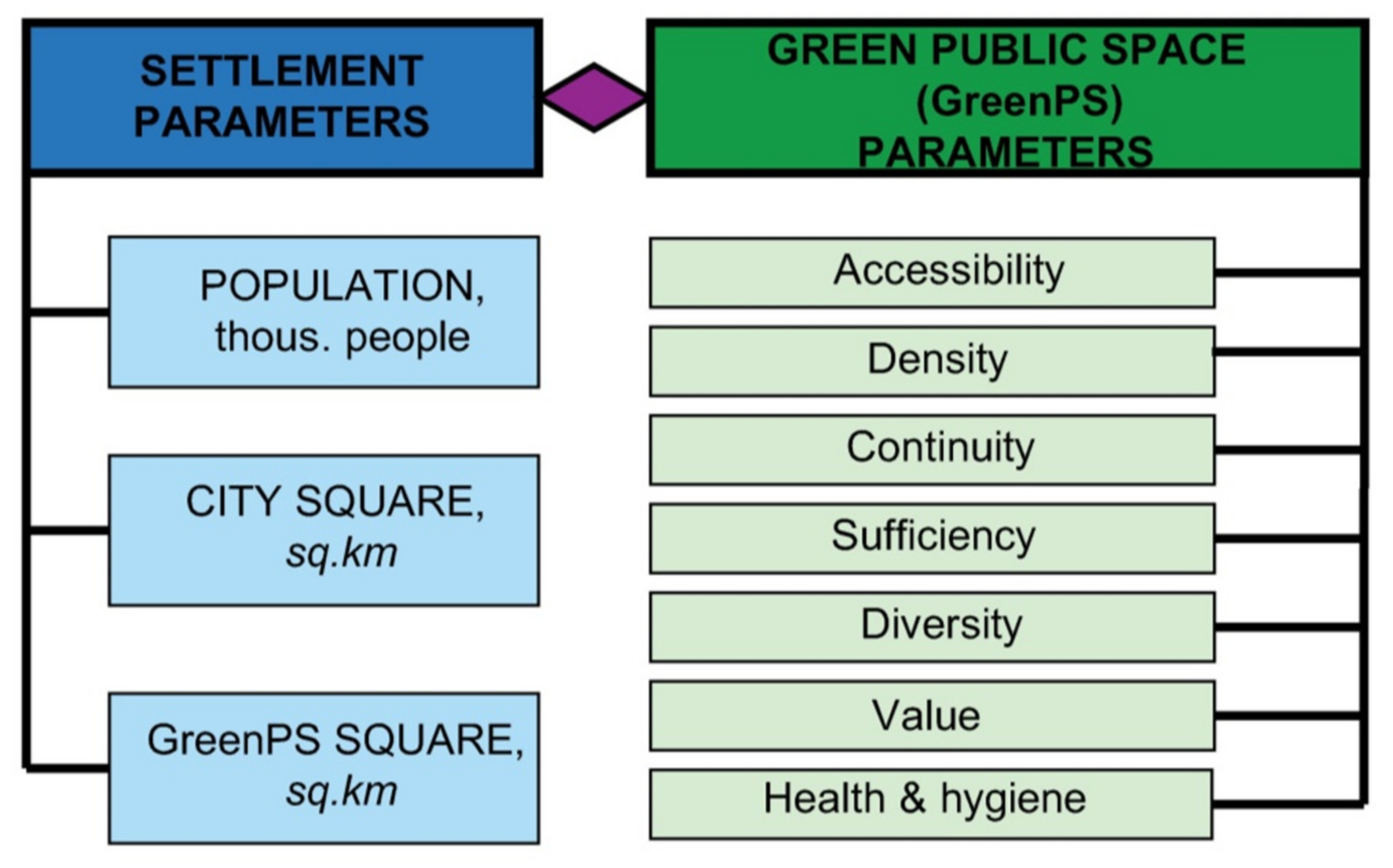
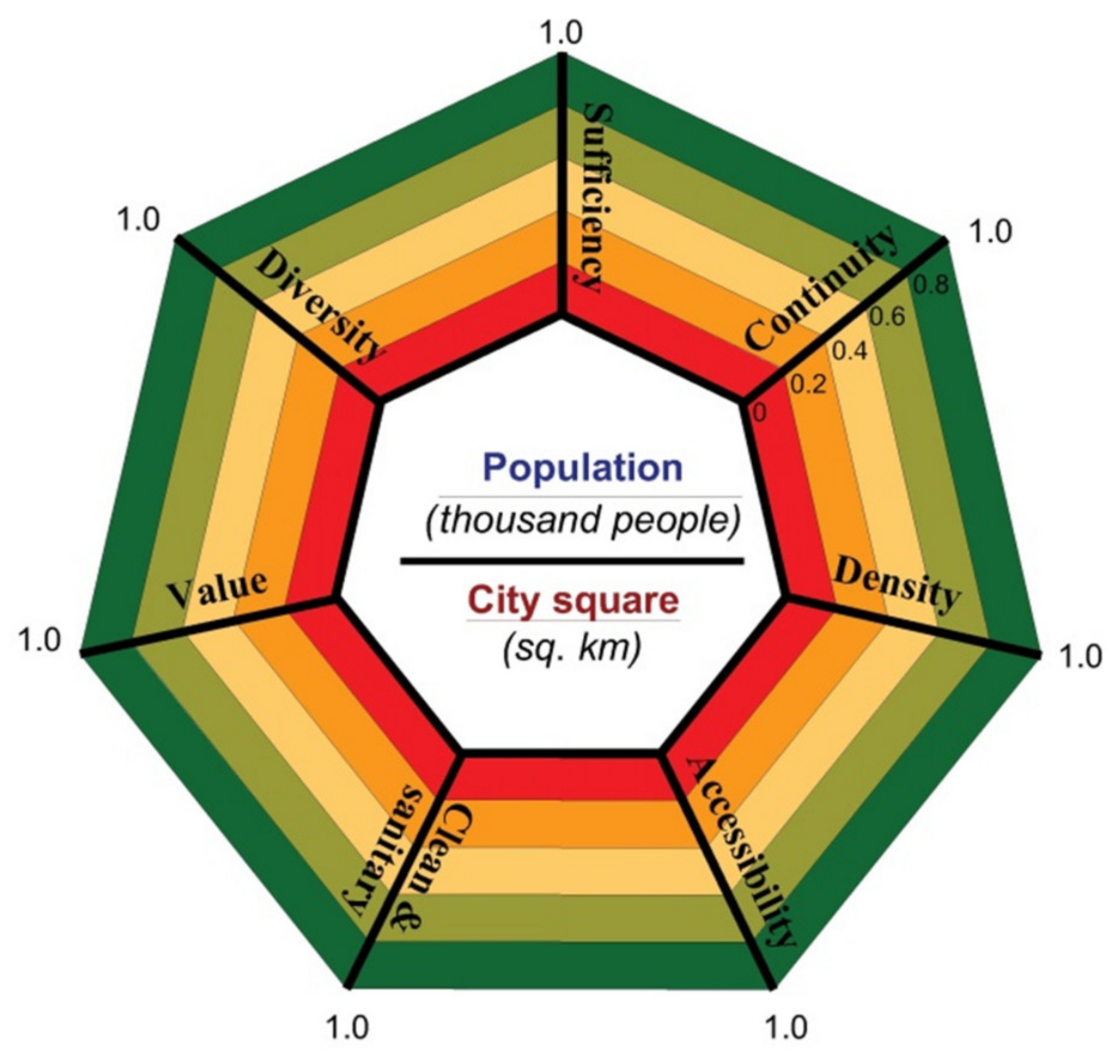
  • The basic settlement parameters;
  • The GreenPS parameters.
The above parameters were obtained as from municipality sources, maps and surveys of urban GreenPS distribution by measurements for evaluating public green places which can be integrated into a continuous network of public landscaped places contributing to the city’s sustainability [37,38].
As for the first group, two of the three settlement parameters, namely, city population (N) and city area (total), were obtained from the available official sources produced by the cities governments and provided the necessary information about the city/town scale which further served for calculating the GreenPS network variables. The third parameter—the existing GreenPS area (GreenPS)—was obtained from municipality planning maps and independent surveys and consists of all public areas and corridors with vegetation which should be incorporated into GreenPS network and should be defined by calculating the total area of all the parcels of green public lands within the borders of territorial or functional zone. In Russia, the documents of town-planning zoning constitute the integral part of the City or Town Master Plan. The borders are either red lines which designate borders of the territories public or the borders of the sites of the city-built environment objects.
The second group—GreenPS parameters—represents a set of selected key indicators which describe the sustainable performance of GreenPS on the city level. Qualitative attributes of GreenPS such as comfort, beauty, safety or security were considered as significant contributors to social value of the final project.
Open public space without greening but with potential possibly for landscape restoration as well as greened places without any additional economy or society related function were also considered as the elements of the city GreenPS network and objected to evaluation.
GreenPS accessibility is essential for successful sustainable urban development, for it provides car-free population movement, with the latter generating socio-economic activities [39]. For this reason, measuring the accessibility of a pedestrian network is one of the most discussed problems in modern urban design. In this paper, with regard to the case study cities, the accessibility of GreenPS is considered at the neighborhood scale as the ability of the pedestrians to reach the GreenPS nearest to their location. This conception refers to the walkable accessibility and is measured by time and/or distance. In Russian planning practice, the final destination is considered accessible if it can be reached in 15 min time walk, which corresponds to the 1 km radius distance [26,27,36]. In such case, accessibility is affected mostly by the factors related to land use. Mountain reliefs impact the urban form and built environment, and streets and roads in mountains are curved instead of straight, therefore, the actual time for a 1 km walk was measured. An isochrone map was used to depict the areas accessible from GreenPS within the 15 min time threshold.
GreenPS density in urban fabrics is also critical to reduce the use of private motorized vehicles and enable quality of city life and sustainability [37]. A variety of ways of measuring different kinds of urban densities have been central to numerous theories relating to urban form to city life, resulting also with an integrative approach towards conceptualizing urban density within a framework of assemblage theory [40]. Giving credit to all studies and attempts, in this work we apply the most common way of density measure, expressed as a percentage: the ratio of total city GreenPS space to city residential area [8]:
D N = S G r e e n P S S r e s
where:
  • DN—GreenPS density coefficient;
  • SGreenPS—the area occupied by GreenPS elements, square kilometers;
  • Sres—residential area of the city, square kilometers.
Since the results of the reliable research studies related to green space supply in Europe cities [8] show that for the cities recognized as green, this coefficient does not exceed 0.5, so in this study, this coefficient is taken as the optimum value of GreenPS density.
GreenPS sufficiency was measured on the basis of spatial analysis by calculating the internationally accepted GreenPS index as the ratio of the amount of available city green public space to the total number of city inhabitants:
S u f f . G r e e n P S = S G r e e n P S N
where:
  • S u f f . G r e e n P S —sufficiency index, square kilometers/inhabitant;
  • SGreenPS—total area of the city GreenPS, square kilometers;
  • N—the number of city inhabitants.
In world practice, this index varies from 3 square meters (Tokyo) up to 120 square meters (Vienna) per capita. In line with Russian reference standards [28], this study applies the Sufficiency Index for intercity green spaces of common use (city parks, gardens, squares, boulevards, embankments), which is 9 sq m per capita (for resort cities—15 sq m per capita).
GreenPS continuity contributes a lot to urban ecology and sustainability [41,42]. A well-maintained urban green framework where spatial objects are connected by corridors improves the residents’ mobility, benefits people’s well-being, promotes the use of the GreenPS network and business including tourism. Numerous studies worldwide dealing with continuity of urban public green space agree on the correlation between the continuity of GreenPS and producing health- and well-being-related benefits and promote 100% continuity whenever possible. In this study, the continuity is measured in percentage by the following formula:
C G r e e n P S = S c o n t . S t o t a l 100 %
where
  • C G r e e n P S —the continuity of GreenPS, percentage;
  • Scont.—the continuous parcel of the total GreenPS area, square kilometers;
  • Stotal—the total GreenPS area, square kilometers.
GreenPS diversity in this study means multi-functional performance of GreenPS, involving that diversity of functions and users, which allows for its better performance and potential transformation of separated green places in a GreenPS network [43]. A survey of both domestic and worldwide experience shows that the most important functions (also interrelated) of GreenPS are as follows:
  • greening (lawns, plants, flower beds);
  • physical activities (walking, jogging, running and cycling, fitness, sport games, cardio training);
  • leisure and recreation activities (benches, picnic areas, fountains, spaces for dancing, reading, meditating, probable access to water bodies);
  • play (play areas for children and adults);
  • education and commercial attraction (objects of monumental or architectural heritage, archeological sites, religious services, catering, touristic tours);
  • mobility services (cycling and pedestrian paths, bus stops, parking places).
Diversity Index was calculated as the percentage of functions integrated out of the important ones. The existing data were obtained in the result of the city GreenPS survey. In case of an aggregate estimate, the standard data can be introduced as shown in Table 3.
GreenPS value in this study was evaluated from the perspective of the availability of special eco-related flora and fauna values that enable the place’s use and make it attractive for investments, for example:
  • endemic areas of historical value;
  • protected areas with rich biodiversity;
  • unique bird or animal reserves.
The GreenPS value Index was calculated as the percentage of values available out of the probable. The existing data were obtained in the result of city GreenPS survey. In case of an aggregate estimate, the standard data can be introduced as shown in the Table 3.
GreenPS clean and sanitary refer to the most important life conditions that influence the health of the people and, consequently, the efficiency of green places. According to world practice [20,26], specific attention should be paid to clean and sanitary aspects of GreenPS such as:
  • air quality;
  • sufficient toilet and hand washing and sanitizing facilities;
  • closed sewage systems and garbage collection;
  • available clean drinking water;
  • sewage disposal;
  • proper cleaning and sanitation of outdoor equipment and facilities;
  • safe use and handling of pesticides and other harmful chemicals;
  • avoid potentially dangerous pieces of flora and fauna;
  • protection facilities from bad weather (rain, snow, sun heat, etc.);
  • engineered protection facilities from extreme natural phenomena (landslides, floods, tsunamis, etc.)
  • since the year 2020, possibility to provide a sanitary safety distance of 1.5 m.
The Clean and Sanitary index was measured as the relation of existing level of GreenPS Clean and Sanitary supply the modern requirements for engineering and sanitary equipment related to energy efficiency, environmental safety and rational use of resources. The scoring system of the Clean and Sanitary index is proposed in Table 3.
After evaluating GreenPS parameters, the integrative indicator was calculated as IGreenPS, for the assessment of GreenPS network’s impact on substantial development of the city. The integrative indicator was measured by the arithmetic mean, taking the sum of the indices’ values, then divided by the count of the numbers:
I G r e e n P S = 1 n I n n
where Table 3 shows how to calculate the indices and measure the integrative indicator. The maximum value for each index In—1.0 corresponds to 100% achievement value related to a standard or target one. The standards for green public places Accessibility, Density and Sufficiency conform to valid Russian norms and regulations, whereas the grade values of Continuity, Diversity, Value and Clean and Sanitary were defined on the basis of domestic and worldwide scientific and planning practice experience obtained from literature sources.
The integrative indicator accounts for the total set of the incoming parameters. The radial line graph helps to present the results clearly by mapping a list of parameters, from the minimum to the maximum of the extent of the diagram, wrapped around a circle (Figure 6).
Connected data points of each parameter (estimated as it is shown in Table 3) display the integrative indicator of the city GreenPS network’s present state.
The integrative indicator allows for plan definition and designing the project proposal for further development and management of the GreenPS network.
The second phase of the methodology consisted of defining the GreenPS network structure by analysis of a city/town maps, official documents, strategies, activities, etc., related to land use and spatial planning, aimed at identifying the availability of public land that could be integrated into the city GreenPS network, especially with regard to the plots that could be:
  • Renewed for creating new GreenPS;
  • Reconstructed by integrating functional diversity;
  • Revitalized by building attractive green and cultural environment;
  • Modernized by using green, energy-efficient and technologically advanced equipment.
The third phase of the methodology included the designing of the specific proposals for implementation and developing of the GreenPS network as the basis of the city green infrastructure to be considered during the Master Planning process, with a special concern for the following measures:
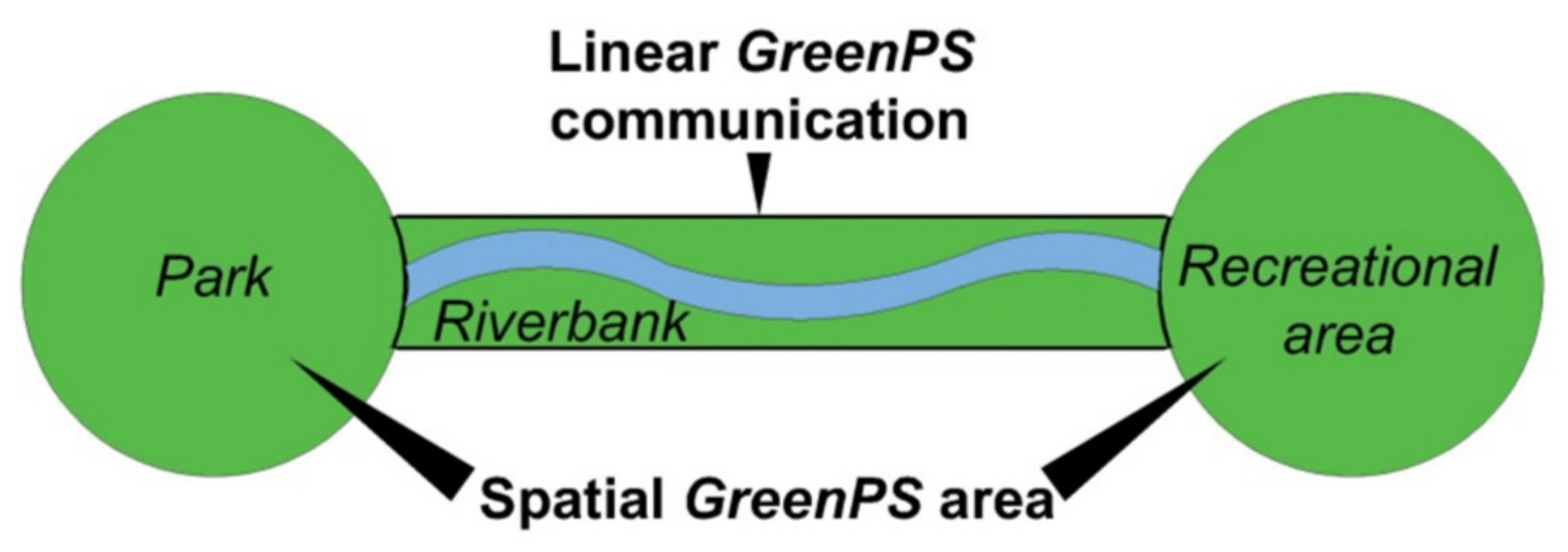
  • New areas incorporating sustainable GreenPS land use, such as street sections, embankments, seafronts or pedestrian bridges and walkways, footpaths to be used as connecting corridors aimed at providing the Continuity, Accessibility, Density and Sufficiency of the GreenPS spaces network;
  • Renovating already present GreenPS by multiplication of social, business and environmental functions to increase Value and Diversity indices;
  • Investing in green facilities addressing improving the Cleanand Sanitary index, such as public toilets, efficient drainage, clean water supply and clean air monitoring.
Integration of these strategies addressed on continuous eco-oriented development and good management of the city GreenSP backbone into master planning should provide health and safety, sustainable city development as well as promote its beautification.

3. Results

3.1. The Data Collection Results
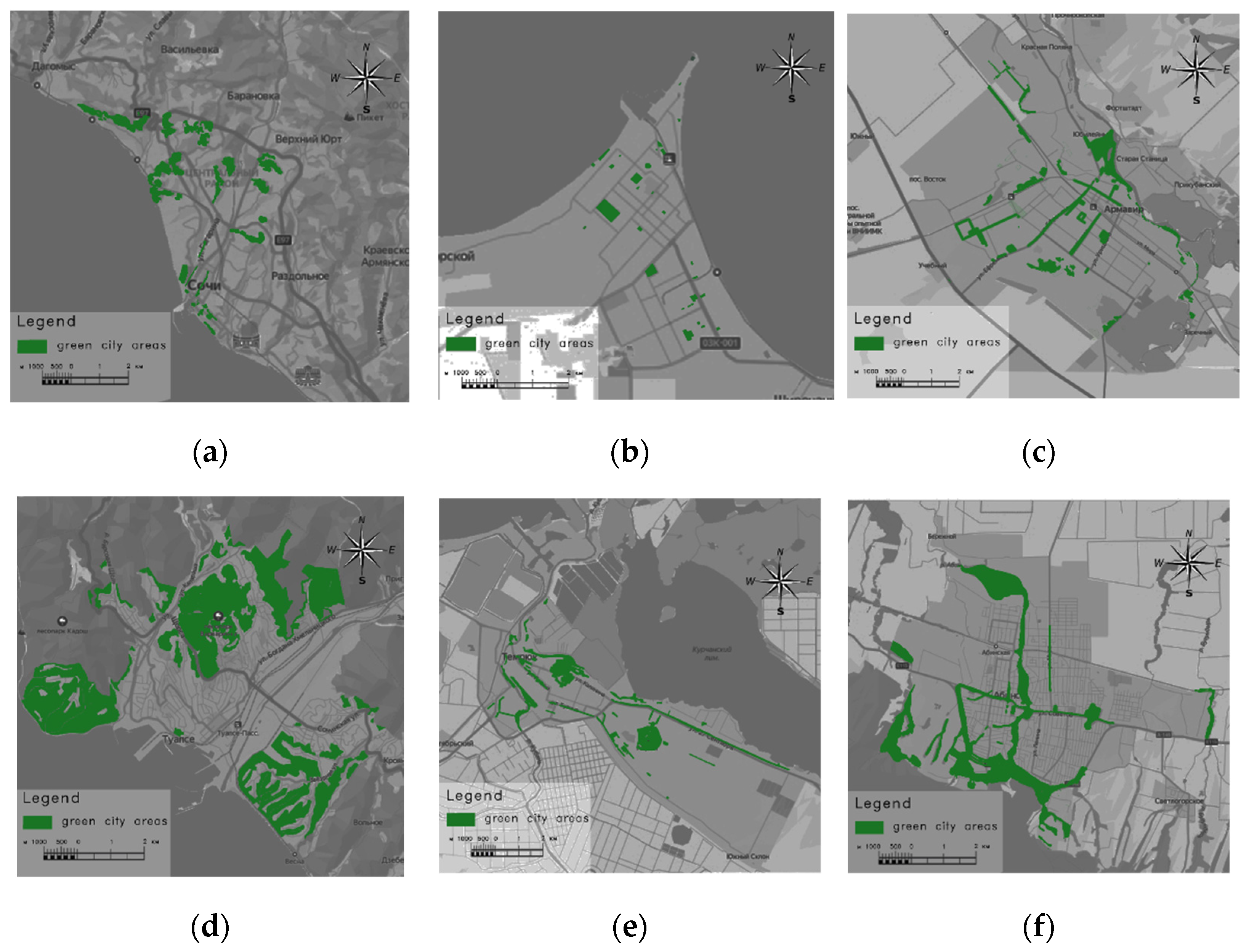
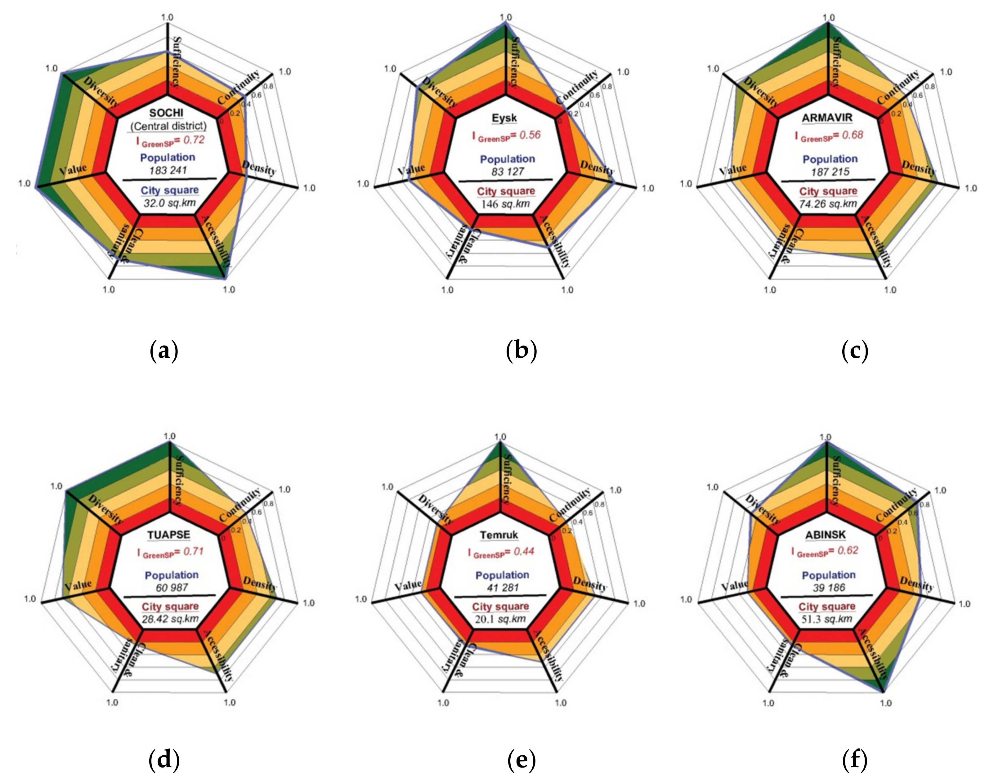
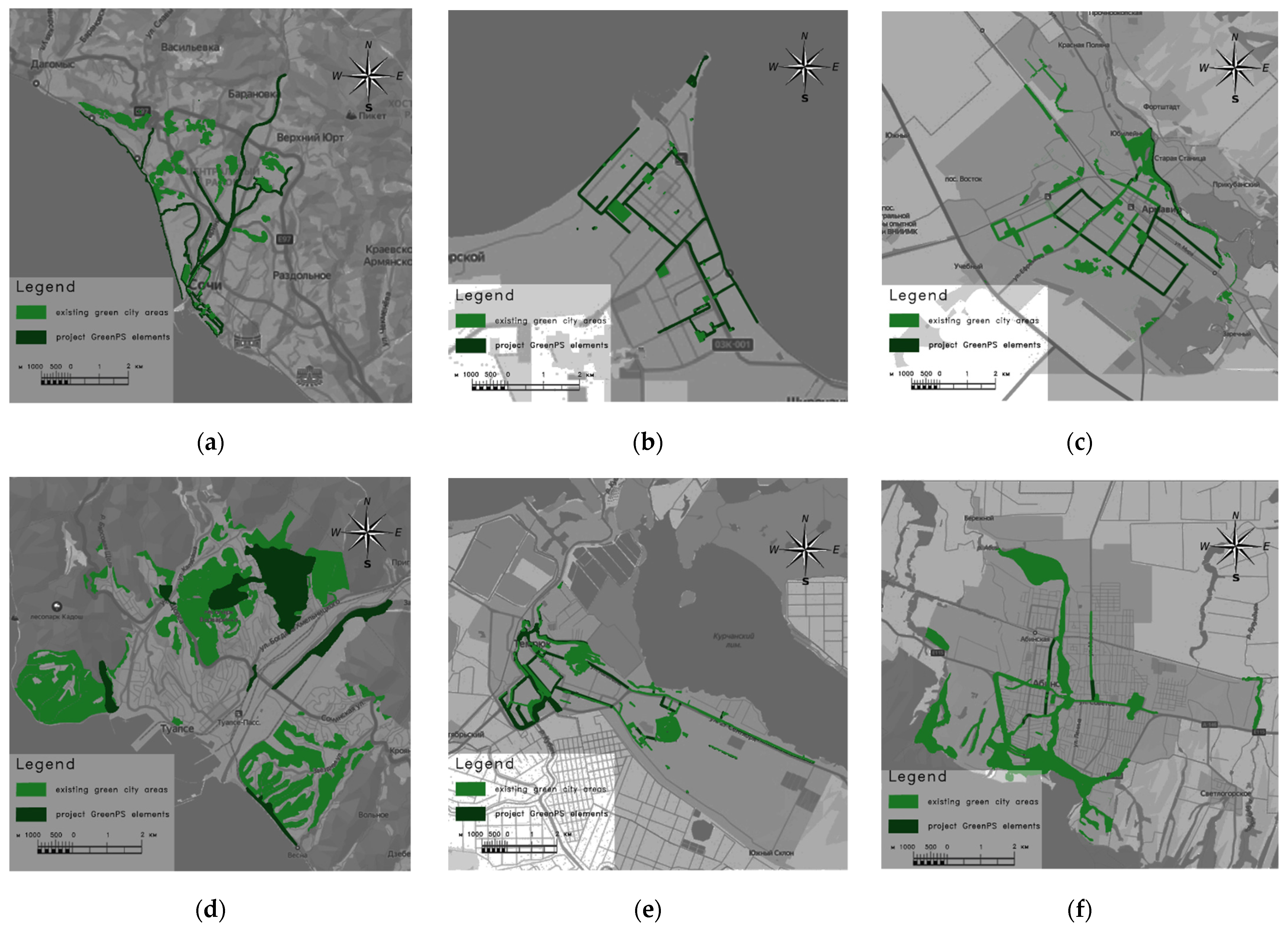
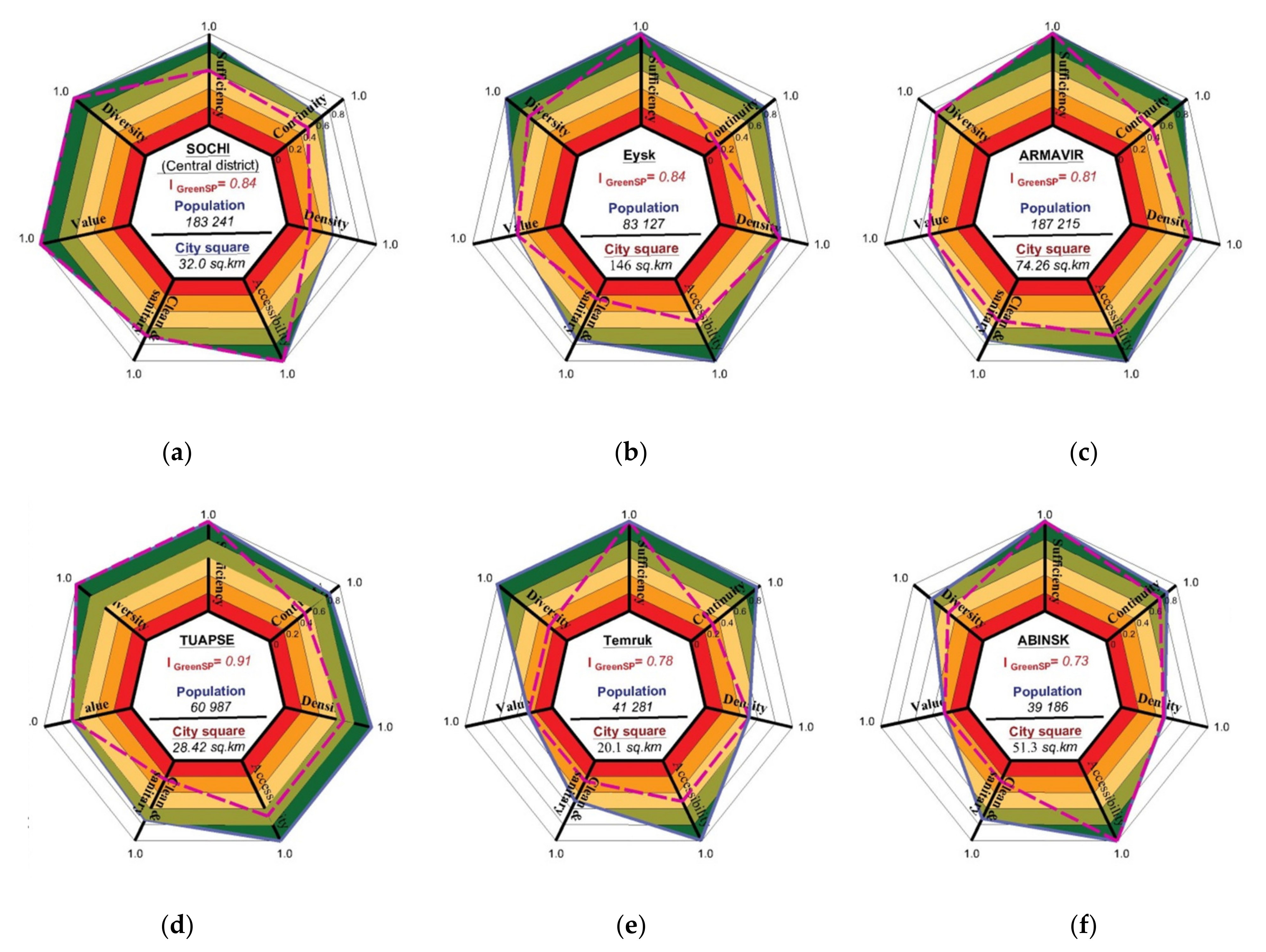
The structural plans of each city selected for this study are different, but all of them were built and developed during the Soviet Union period on the basis of the same Soviet-type master planning approach based on state-owned land and housing and a single economic plan directing the national economy. Soviet rules and norms for building and planning cities also included greenery norms provided for different types of green zoning that depended on city classification based on population number and density, such as a forest-park belt around the huge city, landscaped buffer zones between different industrial zones and abundant minimum greenery norms for inhabitants within residential areas. Actual greenery figures fall far short of the legal minimum, but still, all the cities selected have sufficient urban space that allows for the creation a GreenPS network capable of providing the sustainable development of the city, including the aspects of climate change mitigation and adaptation.
The cities are monocentric with the aggregation of population and social and economic life being focused in the well-defined center. Public spaces—roads, public squares, parks, beaches, embankments, etc.—are typically wide but at low levels of comfort, safety and infrastructure provision, while regular urban built up and efficient land use decreases with the increasing distance from the center.
The data on the city territories—the total area of the city land, the shares of land in residential and recreational use—were taken from the comprehensive policy documents—City Master Plans placed on local government websites.

3.1.1. Sochi

The total area of the case study—Central Sochi (Central city district)—is 3200 hectares, 1900 hectares of which are occupied by a residential area. The main city-wide green belt stretches along the seashore; it is occupied by the city’s beaches and resort areas. It includes a chain of parks, scenic landscaped public spaces adjacent to historical buildings, large public buildings, hotels and restaurants. The total public green area is 167 hectares: 123 hectares are the forests where ecological benefits prevail upon social functions, and the remaining land includes 11 zones which occupy the areas ranging from 30 hectares to 0.5 hectares.
  • Accessibility: Sochi is located on the slopes of the Great Caucasian chain. Foothills and large local differences in elevation explain the poor accessibility of green areas: straight-line access to green facilities alternates with prolonged climbs or descents. The access time can be more than 30 min. The average is 15-min access.
  • Density: The Density coefficient of the city-wide green belt is equal to 0.087.
  • Sufficiency: The sufficiency indicator of the GreenPS constitutes 9 square meters/inhabitant.
  • Continuity: GreenPS are linked mostly by linear corridors, such as the embankments and paths along the rivers descending from the mountains to the sea, and provide for 65% of the GreenPS Continuity.
  • Diversity: The Diversity coefficient is high and can be evaluated equal to 100%: All Central Sochi parks are multifunctional and provide a variety of ecological sites for special events, festivals, sports tournaments and educational and recreational activities, which are the major sources of tourism and social and economic benefits.
  • Value: 100%: the warm Mediterranean climate creates unique conditions for rich biodiversity of local flora and fauna.
Riviera Park (14.7 hectares), for example, is the city’s largest green place by area; it is divided into several zones to locate dendrological collections, statues, games, art galleries, dolphinarium, cafes and even beautiful magnolia trees planted by Russian astronauts in the name of peaceful space exploration. In addition, the Japan Garden, known as the Garden of Russian–Japanese Friendship, covers the area of 0.6 hectares in the very center of Sochi near to Kurortny Prospekt. It represents everything that grows in a traditional Japanese garden and also other exotic plants brought from Asian countries, and, in addition, include lanterns, bridges and statues scattered throughout the park.
The Clean and Sanitary indicators of the GreenPS are sufficient (75%). All parks are equipped with sanitary devices, but there is poor waste management and a lack of energy-efficient technologies and equipment.

3.1.2. Tuapse

Tuapse, the city and seaport, lies on a sheltered bay of the Black Sea. The area of the city covers 2842 hectares, while the total area of the residential and public part of the city is 550 hectares. The green city facilities include forest parks, green spaces of general use, green spaces of limited use on individual and multi-apartment housing stock plots as well as on the territories of hospitals, schools, kindergartens, stadiums and also green spaces for special purposes. Forest parks are located mostly at Cape Kadosh, in the western part of the city adjacent to Kalarasha street, at Varvarina, at the central part of the city and at the northeastern part of the city near the oil refinery.
In the historical area of the city, there is a GreenSP backbone which consists of a city park, a pedestrian Karl Mark Boulevard, a set of squares adjacent to the embankment, stadium, railway station, along Pauk riverside along Frunze street, and a green area on the left bank of the Tuapse River near the city beach.
  • Accessibility: The city’s terrain is rugged. The absolute altitudes range from 0 m above sea level to 422 m above sea level (Mount Bezymyannaya). However, due to the existing GreenPS backbone, the average accessibility is 20-min access.
  • Density: The Density coefficient is equal to 0.52, but almost 40% of GreenPS is not landscaped and it is rarely used.
  • Sufficiency: The total area of public green areas in Tuapse is 105 hectares, and the supply of green space is 50 square kilometers/inhabitant.
  • Continuity: GreenSP continuity constitutes 45%.
  • Diversity: The major part of the GreenSP network integrates various functions and serves local needs.
  • Value: City forest parks have a wide range of unique natural environmental elements such as flowers, trees, shrubs, etc.
  • Clean and Sanitary: The infrastructure and equipment are inadequate.

3.1.3. Yeysk

Yeysk is a port and a resort town on the shore of the Taganrog Gulf of the Sea of Azov. It occupies in total 14,668 hectares of land. The total area of residential area is 1266.3 hectares. The place of its location—the Yeysk Peninsula—is characterized by a flat relief and lack of greenery due to sandy soils. The city is a noted health resort, famed for its medicinal sulfur and mud baths. However, a predominant private sector, a railway line running through the city and low-maintenance landscaping create low-quality GreenPS.
The total area of the green territories is 1306 hectares. However, only 748 hectares of them belong to public places, and according to the results of the analysis, only 164 hectares are located in the inhabited part of the city and are used by residents. The surveys revealed seven green areas with an area from 19 to 0.2 hectares and several linear streets that can be included in the GreenSP backbone as connecting corridors. The largest are the embankment of the Azov Sea and the park Poddubny. More than 75% of GreenPS are uncomfortable and elemental, without function services and sanitation. Thus, the main indicators of the GreenPS sustainability are as follows.
  • Accessibility: Maximum 30-min access to GreenPS.
  • Density: the actual Density indicator is 0.12, while the estimated Density can be increased up to 0.66 by integrating the existing renewed green areas into GreenPS backbone.
  • Sufficiency: The supply of landscaped area of public use is 20.1 square meters/inhabitant.
  • Continuity: The present Continuity of the GreenSP backbone is 18%.
  • Diversity: Only walking.
  • Value: The flora and fauna of the green carcass is assessed as sparse.
  • Clean and Sanitary: Inadequate infrastructure and equipment.

3.1.4. Temruk

Temruk is located in the territory of the Taman Peninsula, which separates the Black and Azov seas and is cut by many estuaries, on the plain steppe part of the Krasnodar Krai. The total area of the city covers 2010 hectares, the residential area occupies 1445.2 hectares and the green areas of the city occupy about 175 hectares. The city’s green spaces consist of natural objects such as Mount Misca, Mud volcano Hephaestus, Mount Rotten, as well as city parks, alleys and green streets, ranging from 100 hectares to 0.5 hectares. The city is famous for its mud volcanoes: There are 25 of them in the area and some are still active.
  • Accessibility: Maximum 30-min access to GreenPS.
  • Density: The Density indicator of the GreenPS framework is 0.12.
  • Sufficiency: The green areas of the city occupy about 175 hectares, the GreenSP supply is 43.75 square meters/inhabitant.
  • Continuity: Since GreenPS are mostly large separate plots of land, the continuity of the backbone constitutes only 33%
  • Diversity: Generally, GreenPS areas serve both residents and tourist.
  • Value: Local natural objects, such as mud volcanoes, have a unique value in terms of flora and fauna.
  • Clean and Sanitary: Inadequate infrastructure and equipment.

3.1.5. Armavir

Armavir is located inside the mainland of the region, on the left bank of the Cuban River, about 202 km to the southeast of Krasnodar. It is an important railway hub of the region. The total area covers 7426 hectares. The residential area covers 1422.09 hectares. The comfortable green areas of Armavir include both existing and projected city parks, squares, alleys and boulevards with a projected area of 295.04 hectares by the year 2033. Visitors and tourists always admire the abundance of the city’s green places. Street landscapes influence house architectural style and block solar heat in the summer, providing comfortable shading for pedestrians and reducing road noise. Eight main equipped green zones with an area from 0.5 hectares up to 13 hectares were identified in the city, as well as abundant street trees and landscaping. There are both parks and linear green corridors.
The nature of Armavir accommodates a variety of native trees, shrubs and flowers, while rare representatives of flora a fauna were not observed. All green areas are multifunctional and provide diverse social and economic ecology-related services also addressing the cultural, educational and historic interests of the public. The Clean and Sanitary index was rated as satisfactory.
  • Accessibility: Maximum 20-min access to GreenPS.
  • Density: The Density index of the GreenPS backbone is 0.21.
  • Sufficiency: The supply of green spaces is 15.8 square meters/inhabitant.
  • Continuity: The GreenPS Continuity constitutes 52%.
  • Diversity: 75%.
  • Value: 25%.
  • Clean and Sanitary: Inadequate infrastructure and equipment.

3.1.6. Abinsk

Abinsk is located at Kuban-Azov lowland, on the river Abin, 75 km (47 mi) southwest of Krasnodarhas. It occupies the area of 5135.4 hectares and has a particular potential for public green spaces development. The residential area covers 2023.3 hectares and green area covers 245.5 hectares. The GreenSP backbone includes various recreation places, parks, squares, tourism and sports plots and also natural monuments. The largest natural green objects include six objects ranging from 29 to 0.5 hectares.
The city is crossed by the Abyn River, which has a 20-m wide greened coastal line 8.7 km in length, at a 15 min walkable distance from any part of the city. It provides the continuity of the GreenPS backbone linking several city parks and also has intersections with the main highways of the city’s road network, which have recreational potential.
Thus, the GreenPS backbone is almost never interrupted, which is confirmed by the zoning scheme of the green space. The set of functions of green areas is not diverse and is limited to walking. Local flora and fauna have been identified. The Clean and Sanitary indices are mostly in poor condition.
  • Accessibility: 15-min access to GreenPS.
  • Density: The actual Density indicator is 0.12.
  • Sufficiency: 62.6 hect./inhabitant.
  • Continuity: 75%
  • Diversity: 25%
  • Value: 25%
  • Clean and Sanitary: Unsatisfactory.

3.2. General Findings on the Present State of GreenPS

The spatial analyses of cities’ land use plans overviewed in Figure 7 allow for the visualization of the present state of the city GreenPS, which can form the basis for further GreenPS network development.
The analysis of the present situation revealed that each city has various types of GreenPS, such as parks, forest parks, squares, boulevards, alleys, embankments and greened streets. Green areas with limited public access, as well as public spaces without greenery, were not considered. Table 4 represents the summary data that describe the present state of GreenPS networks in each city based on the evaluation of seven parameters of GreenPS sustainability selected for this study.
Table 5 represents the results of the calculations of integral indices of each indicator. The Radial line graph in Figure 8 gives a complex vision of the present state of things in each city.
The results of data collecting can be interpreted as follows:
  • The accessibility index in all cities is not lower the average, while in Sochi and Abinsk it is rated at 100% and corresponds to the regulatory standard. The lowest indices are in Yeysk and Temruk, located in steppe zones, where trees grow only near rivers and lakes, the vegetation is dominated by grass and shrubs and urban parks are artificially created and not interlinked. The absence of green linear corridors prolongs the access time to parks and other green public areas.
  • The density indicator varies in the range of 0.5–0.75 and witnesses the presence of public green spaces in all the cities under consideration.
  • The sufficiency indices in all cities except Sochi have a rate of 100% and thus correspond to regulatory standards, since it is the only mandatory standard that remained after the collapse of the Soviet Union and is still applied in master planning. Sochi lags behind due to the high rate of development and intensive growth of its population.
  • The continuity standard is not yet applied in Russian approaches to city planning, thus positioning our urban studies out of the actual international context. The main problem is that there is no object of standardization: green corridors along city streets, embankments, coastal lines, etc., are often very rare (Yeisk and Temruk), and pedestrian boulevards and alleys are located mainly in the central parts of the city. Only coastal cities, located both at the seashore and at the river bank, such as Sochi, Tuapse and to some extent Abinsk, enjoy the embankments which play the role of linear corridors and connect GreenPS, thus creating continuity in the green network of the city.
  • The GreenPS network is not to be confused with a single GreenPS. Although the GreenPS network should be green and include water bodies and boulevards if possible, it must also integrate a diversity of different ecology-oriented social and economic functions. The Diversity of the GreenPS network in the cities under consideration varies from no presence to multiple presence of spatial functions related to ecology-oriented social and economic activities: Neglected green lands were observed (Temruk and Abinsk), and so were multifunctional places serving a total range of sustainable benefits (Sochi, Tuapse, Armavir). Public lands prohibited for public access were not taken into consideration for future green network development. The proposition that the functional diversity of GreenPS network is related to city population number and economic prosperity needs further research.
  • It is worth mentioning the finding that the Value of green areas in the cities selected for case study obviously depends on the climate. For example, Sochi and Tuapse, located in a warm, humid Mediterranean climate with subtropical features, enjoy both natural diversity and artificial dendrological parks and zoos. However, the steppe-located cities with continental climate features (Yeisk, Temruk, Abinsk) are quite poor in vegetation and animals. Armavir, the fourth largest city of the Krasnodar Krai, located at the picturesque banks of the Kuban and Urup Rivers, in addition to valuable local biodiversity of flora and fauna, pays special attention to further beautifying and ecologizing the city. Planted cypresses, plane trees, maples, chestnuts, azaleas and boxwoods and exotic flowers increase the Value of the city’s GreenPS network, improve the ecology of the city and make it healthier and more picturesque.
  • The Clean and Sanitary index is the only one that does not satisfy the required standard in all the cities, which is unfortunately typical for Russia as a rule. The situation is a little better in big resorts and large cities (Sochi, Armavir), while the smaller the city, the less is the concern about this parameter.

3.3. Results on Defining the GreenPS Network Structure

The analysis of city/town maps, official documents, strategies, activities related to land use and spatial planning was aimed at identifying the availability of public land that could be integrated into the existing GreenPS network. In the result of the analysis, the following features were revealed common to all the cities under study:
  • All the cities already have the elements of the GreenPS network—city parks, forests, squares, embankments, etc.
  • All the cities have rare connecting elements linking green places.
  • All the cities have wide streets developed during the Soviet period with sufficient place for transport, pedestrian and walking paths and greening that allows for reconstructing and integrating these streets into the GreenPS network as linking corridors.
  • The cities located on the Black Sea cost have mountainous terrain, which impacts the network Continuity. However, the same cities enjoy Mediterranean and subtropical climates favouring the performance of other indices, such as biodiversity Value.
  • The cities located both on the Azov Sea cost and inside the mainland have more or less the same parameter indices due to similar steppe plain terrain and grassland vegetation.
Based on common planning prerequisites identified during the study process and the radial line graph data, the following common objectives for master plan proposals were identified:
  • To promote the 100% continuity degree of the GreenPS network whenever possible;
  • To improve GreenPS network Accessibility, Density and Sufficiency;
  • To maintain the present performance of the Value parameter;
  • To consider the Diversity parameter as an essential one for developing the city’s GreenPS network and improve its performance to possible maximum;
  • Consider the actual Clean and Sanitary index as the satisfactory one in view of the common domestic state of things.
Furthermore, the implementation of the objectives as well as project preferences depend on specific planning prerequisites of each town reported below.

3.4. Results on the Designing of Specific Proposals for GreenPS Development Planning

3.4.1. Sochi

A low degree of continuity and the absence of free public land due to the high building density are the main challenges in improving the sustainability performance of the GreenPS network in Sochi. Thus, the main attention was dedicated to creative renewing, reconstruction and integration of the existing and already developed public spaces aimed to meet the objectives of the green public network development, such as renewing streets to be used as the green corridors linking GreenPS; incorporating green route “Sochi” into the GreenPS network; reconstructing the seaside embankments; arranging the green corridor along the Psahe River; and building eco-parks using existing natural green places.
Such measures raise the Density index up to 0.18 degrees and the integration indicator up to 0.5 degrees. The Sufficiency parameter will constitute 17.6 square meters per inhabitant, and the Continuity improves up to 70%. The renewed city master plan is presented in Figure 9. The integrative indicators are reported in Table 6.

3.4.2. Tuapse

A low degree of continuity was also identified in Tuapse. However, unlike Sochi, the city has a good reserve of green public lands, which allows for an 18% increase in the total green public area, which amounts to 1814 hectares. Thus, the main attention was paid to improving the quantity and quality of the GreenPS network’s social functions and services. Identifying the streets suitable for linking GreenPS and creating a GreenPS network allowed for upgrading the Continuity index performance up to 91%. In addition, the Accessibility improves to 15 min. The renewed city master plan is presented in Figure 9. The integrative indicators are reported in Table 6.

3.4.3. Yeisk

The project proposals for Yeysk’s master planning contained the reconstruction and renewal of the city’s public spaces, considering them as spatial or linear elements of the GreenPS network. It includes greening streets; creating coastal park space; reconstruction of City Park, Poddybny Park, Gorky Park and Nikolsky Park; and building a pedestrian zone along the Yeisk estuary. After the reconstruction, the total public green land would cover 400.3 hectares, while the Sufficiency index will be 31.5 square meters/inhabitant. The continuity index would increase from 18 to 85%. The renewed city master plan is presented in Figure 10. The integrative indicators are reported in Table 6.

3.4.4. Temruk

Temruk does not lack public ground but suffers poor greening due to its steppe location characterized by grassland plains. Project proposals made in the framework of this study related to creating new and renewing existing public green places, such as the improvement and greening of the Kuban River embankment, building new city parks and landscaping and greening the Kalabatka Quarter. In addition, it is proposed to create additional linear green corridors aimed at connecting presently separated GreenPS around the town, reconstructing for this purpose the existing streets of the city, such as Rosa Luxembourg Street, Kalinin Street, Stepan Razin Street, Lenin Street and Chernyshevsky Street. The implementation of the above measures will increase the green public area to 230 hectares and, consequently, improve the Sufficiency index to 55 square meters/inhabitant. The Density of the backbone will be 0.18 and the Continuity 88%. The renewed city master plan is presented in Figure 10. The integrative indicators are reported in Table 6.

3.4.5. Armavir

Ample amount of public ground was identified in Armavir suitable for creating recreational green places along the Banks of the Kuban River. Reconstructing and adding these lands to the GreenPS network will significantly improve the well-being of the inhabitants. The implementation of this ambitious project will probably “unload” the center of the city, and the vacated land would be used for focusing urban activities within the limits of historical settlement. The project proposals include building new recreational and transit ecology-oriented zones and bank protection measures related to the construction of the embankment that allows for achieving 93% Continuity. The total area of the GreenPS network will become 401 hectares. The Density index will be 0.28, while the Sufficiency will constitute 28.2 square meters/inhabitant. The renewed city master plan is presented in Figure 10. The integrative indicators are reported in Table 6.

3.4.6. Abinsk

Abinsk enjoys a quite acceptable state of its GreenPS network. Therefore, the project proposals consisted of designing several sustainable additions to the present situation. It is proposed to enrich landscaping at the points of network interruption, mainly along the street network, by building buffer zones or green linear corridors or boulevards. In addition, it is recommended to interconnect the existing green places located at the southwestern part of the city using already existing but not yet organized public ground. In addition to plan changes, internal infrastructure improvements of the most natural city objects are suggested. In the result of these arrangements, the total area of GreenPS will constitute 360 hectares, the Density index of the GreenPS will be 0.18 and the Sufficiency index will be 17.7 square meters/inhabitant. The renewed city master plan is presented in Figure 10. The integrative indicators are reported in Table 6.
The project proposals and recommendations in the framework of this study result in creating a city GreenPS network as the basis for cities’ sustainable developments by improving the performance of the GreenPS parameters related to sustainability. The performances of the indices of Diversity, Value and Clean and Sanitary are not considered while designing project proposals but are expected to be considered upon further elaboration of the project and are relevant to support the efficient management of the GreenPS network.
Table 6 summarizes the projected GreenPS network indices while Figure 10 visualizes the integrative indicator of the GreenPS network sustainability by means of a radial diagram.

4. Discussion

The results of the study reveal several research problems. The first deals with the difference between the terms green place and public green place, green network and public green network. Foreign authors do not distinguish these terms [13,19,31] because, by default, all green places in the city serve not only ecological but also social life. However, the case study of Russian cities indicates the necessity of a clear definition of the lands that can be included in the green city network because not all green places in Russian cities are in social use on the one hand, and not all public spaces can be integrated into city green backbone [16,36]. For Russia, it seems necessary to introduce the additional terminology and specific approaches to creating just GreenPS, underlying their social function. The second problem is related to obligatory standards necessary to be considered in the city master planning. Today in Russia, there is only one such standard—the supply of green public land per person. However, foreign researchers offer a number of additional indicators that describe it both qualitatively and quantitatively [7,13,17,19,31,32,34,35]. This study witnesses that the use of only one parameter, the sufficiency one, does not describe the GreenPS backbone. At 100% sufficient supply of public green land for one city inhabitant, such lands can be located far from residential areas, be poorly equipped, lack social functions, etc. In light of the above, the methodology presented in this study has a practical novelty for updating the Russian regulatory norms related to city planning and developing design guides. In addition, the study proves that the GreenPS backbone must have continuous spatial structure in the city layout. In ecological terms, this should ensure the “town–nature” system, which means creating conditions for the harmonious inclusion of the city in natural biogeocenosis and responses to climate change challenges, not to mention such well-studied aspects, that the continuity of green city places positively enhances the use of GreenPS, promotes sustainable mobility and benefits people’s well-being [39,40].
In addition, the problem may be that the proposed GreenPS assessment method is based on several criteria. The suggestion is to reward the solution with the highest scores. However, it is possible that some criteria contradict each other. To solve the problem, further development of the topic is necessary, for example, the possibility of implementing the TRIZ method, which is universal and allows solving contradictions in the field of environmental design [44,45].
The study raises a number of other questions about the influence of natural factors, such as climate and relief factors on GreenPS development, for example, in the Arctic or in the deserts. The authors understand that the development of the system of normative continuity, density and accessibility indicators for GreenPS backbones needs further research. The presented study initiates a broad field of research and is rather posing a problem than solving it.

5. Conclusions

The introduced concept of Green Public Spaces (GreenPS) is innovative but necessary when speaking about the sustainability of Russian cities and the response to global climate change challenges. The novelty of the term conditions the development of specific domestic methodology to guide implementation of just urban GreenPS networks. The research revealed that Russian cities easily have an already basic network inherited from the Soviet period with good potential for the integration of social functions.
The multi-criteria evaluating method includes the indices already applied in Russian planning practices, so the experience of the world’s greenest cities. The methodology was developed on the case study of six cities located in Krasnodar Krai and proved to be efficient for evaluating the existing state of urban GreenPS, defining specific planning prerequisites and designing project proposals for constructing accessible, continuous, sufficient and multifunctional GreenPS networks which allow for the supply of ecological, social and economic benefits.
The study revealed the main problems and development potentials of green Russian cities, in particular pointing out the fact that usually there is no shortage of land resources in Russian cities, so local initiatives and financing are needed to integrate them in sustainable land use. For this reason, the proposed methodology is considered to be important as it gives to city planners a clear understanding of the requirements to resilient cities and explains how they should be complied. The authors believe that this new approach is feasible, replicable for any other city and it is worth further investigation.
The article is developed within the framework of the Erasmus+ project CLEUX− Climate change and urban planning: European experience. The European commission’s support for the production of this publication does not constitute an endorsement of the contents, which only reflect the views of the authors, and the commission cannot be held responsible for any use which may be made of the information contained therein.

Author Contributions

Conceptualization, N.D.; methodology, N.D.; software, K.T. and V.B.; validation, N.D., K.T.; formal analysis, K.T.; investigation, K.T. and V.B.; resources, N.D.; data curation, N.D. All authors have read and agreed to the published version of the manuscript.

Funding

This work was financially supported by the Ministry of Science and Higher Education (grant # 075-15-2021-686). All tests were carried out using research equipment of The Head Regional Shared Research Facilities of the Moscow State University of Civil Engineering.

Institutional Review Board Statement

This study was approved by the Urban planning section, Scientific Committee of Moscow State University of Civil Engineering (protocol №1 approved on 7 October 2021).

Informed Consent Statement

Not applicable.

Data Availability Statement

The data used to support the findings of this study are available from the corresponding author upon request.

Conflicts of Interest

The authors declare no conflict of interest.

References

  1. Niemelä, J. Ecology of urban green spaces: The way forward in answering major research questions. Landsc. Urban Plan. 2014, 125, 298–303. [Google Scholar] [CrossRef]
  2. Zhao, Y.; Chen, D.; Fan, J. Sustainable development problems and countermeasures: A case study of the Qinghai-Tibet Plateau. Geogr. Sustain. 2020, 1, 275–283. [Google Scholar] [CrossRef]
  3. Bickler, G.; Morton, S.; Menne, B. Health and sustainable development: An analysis of 20 European voluntary national reviews. Public Health 2020, 180, 180–184. [Google Scholar] [CrossRef]
  4. Grigorev, V.A.; Ogorodnikov, V.A. Ecology of Cities in the World, Russia, Syberia; GPNTB SO RAN: Novosibirsk, Russia, 2001. [Google Scholar]
  5. Petukhova, I.M. Ecological network as a tool for preserving nature network of Yaroslavl. Yarosl. Pedag. Vestn. 2004, 1–2, 177–181. [Google Scholar]
  6. Tan, P.; Hamid, A. Urban ecological research in Singapore and its relevance to the advancement of urban ecology and sustainability. Landsc. Urban Plan. 2014, 125, 271–289. [Google Scholar] [CrossRef]
  7. Cocklin, C.; Harte, M.; Hay, J. Resource assessment for recreation and tourism: A New Zealand example. Landsc. Urban Plan. 1990, 19, 291–303. [Google Scholar] [CrossRef]
  8. Wolff, M.; Dagmar, H. Mediating Sustainability and Liveability—Turning Points of Green Space Supply in European Cities. Front. Environ. Sci. 2019, 7, 61. [Google Scholar] [CrossRef] [Green Version]
  9. Kazakov, N.A.; Eremeeva, S.S.; Karaganova, N.G.; Mihaylova, E.V. Nature recreational network of city district and the valleys of small rivers (on the example of the city of Cheboksary). Successes Mod. Nat. Sci. 2018, 7, 136–141. [Google Scholar]
  10. Baklajenko, E.V.; Matveenko, Y.D. Modern problems and prospects for the development of urban parks as elements of the natural framework. High-Tech Technol. Innov. 2019, 3, 10–14. [Google Scholar]
  11. Kravchuk, L.A.; Homic, V.S.; Struk, M.I.; Sanec, E.V.; Ovcharova, E.P.; Jivnach, S.G.; Romakevich, E.A. The natural framework as the basis of the green infrastructure of an urbanized territory. Ecol. Geogr. Probl. Transit. Green Econ. 2019, 1, 116–131. [Google Scholar]
  12. Wu, J. Urban ecology and sustainability: The state-of-the-science and future directions. Landsc. Urban Plan. 2014, 125, 209–221. [Google Scholar] [CrossRef]
  13. Teng, M.; Wu, C.; Zhou, Z.; Lord, E.; Zheng, Z. Multipurpose greenway planning for changing cities: A framework integrating priorities and a least-cost path model. Landsc. Urban Plan. 2011, 103, 1–14. [Google Scholar] [CrossRef]
  14. Sidorenko, M.V.; Yunina, V.P. The role of the ecological framework in the preservation of natural complexes on the example of the Nizhny Novgorod Volga region. Ecol. Probl. Basins Large Togliatti Rivers 2018, 3, 159–161. [Google Scholar]
  15. Krushelnickaya, E.I. Features of the Natural Framework of the Belgorod Region as a Basis for the Development of Recreation and Tourism Areas; Bulletin of the Belgorod State Technological University named after V.G. Shukhov; Belgorod State Technological University named after V.G. Shukhov: Belgorod, Russia, 2016; Volume 7, pp. 59–65. [Google Scholar]
  16. Panchenko, E.M.; Dukarev, A.G. Ecological Framework as an Environmental System of the Region; Bulletin of Tomsk State University; Tomsk State University: Tomsk, Russia, 2010; Volume 340, pp. 216–221. [Google Scholar]
  17. García, M.C.F.; De Nicolás, V.L.D.N.; Blanco, J.L.Y.; Fernández, J.L. Semantic network analysis of sustainable development goals to quantitatively measure their interactions. Environ. Dev. 2021, 37, 100589. [Google Scholar] [CrossRef]
  18. Yang, Z.; Yang, H.; Wang, H. Evaluating urban sustainability under different development pathways: A case study of the Beijing-Tianjin-Hebei region. Sustain. Cities Soc. 2020, 61, 102226. [Google Scholar] [CrossRef]
  19. Liu, M.; Li, X.; Song, D.; Zhai, H. Evaluation and Monitoring of Urban Public Greenspace Planning Using Landscape Metrics in Kunming. Sustainability 2021, 13, 3704. [Google Scholar] [CrossRef]
  20. Zhao, Y.; Tan, Y.; Feng, S. Does reducing air pollution improve the progress of sustainable development in China? J. Clean. Prod. 2020, 272, 122759. [Google Scholar] [CrossRef]
  21. Levasheva, M.V.; Ryazanova, L.R. Landscape and ecological framework as the basis of targeted design on the example of the organization of the territory for recreational development (Shamanka model site). Vestnik Irkutsk State Univ. 2020, 32, 77–89. [Google Scholar]
  22. Karade, R.M.; Kuchi, V.S.; Kabir, J. The Role of Green Space for Sustainable Landscape Development in Urban Areas. Int. Arch. Appl. Sci. Technol. 2017, 8, 76–79. [Google Scholar]
  23. Swanwick, C.; Dunnett, N.; Woolley, H. Nature, Role and Value of Green Space in Towns and Cities: An Overview. Built Environ. 2003, 29, 94–106. [Google Scholar] [CrossRef]
  24. Laszkiewicz, E.; Czembrowski, P.; Article, A. Creating a Map of the Social Functions of Urban Green Spaces in a City with Poor Availability of Spatial Data: A Sociotope for Lodz Kronenberg. Land 2020, 9, 183. [Google Scholar] [CrossRef]
  25. Jim, C.; Chen, W.Y. Recreation–amenity use and contingent valuation of urban greenspaces in Guangzhou, China. Landsc. Urban Plan. 2006, 75, 81–96. [Google Scholar] [CrossRef]
  26. Schipperijn, J.; Cerin, E.; Adams, M.A.; Reis, R.; Smith, G.; Cain, K.; Christiansen, L.B.; Dyck, D.V.; Gidlow, C.; Frank, L.D.; et al. Access to parks and physical activity: An eight country comparison. Urban Urban Green 2017, 27, 253–263. [Google Scholar] [CrossRef] [PubMed]
  27. Zhang, J.; Yue, W.; Fan, P.; Gao, J. Measuring the accessibility of public green spaces in urban areas using web map services. Appl. Geogr. 2021, 126, 102381. [Google Scholar] [CrossRef]
  28. Danilina, N.; Vlasov, D.; Teplova, I. Social-oriented approach to street public spaces design. IOP Conf. Ser. Mater. Sci. Eng. 2021, 1030, 012059. [Google Scholar] [CrossRef]
  29. Getmanskiy, M.Y.; Shapovalov, M.I.; Varshanina, T.P.; Saprykin, M.A. Functional model of designing a natural ecological framework (on the example of the flat zone of the Republic of Adygea). Ecol. Ration. Nat. Manag. Life Saf. 2017, 1, 132–139. [Google Scholar]
  30. Kil, N.; Stein, T.; Holland, S. Influences of wildland–urban interface and wildland hiking areas on experiential recreation outcomes and environmental setting preferences. Landsc. Urban Plan. 2014, 127, 1–12. [Google Scholar] [CrossRef]
  31. Jing, Z.; Wang, J. Sustainable development evaluation of the society–economy–environment in a resource-based city of China: A complex network approach. J. Clean. Prod. 2020, 263, 121510. [Google Scholar] [CrossRef]
  32. Laurett, R.; Paço, A.; Mainardes, E. Measuring sustainable development, its antecedents, barriers and consequences in agriculture: An exploratory factor analysis. Environ. Dev. 2021, 37, 100583. [Google Scholar] [CrossRef]
  33. Hou, Y.; Long, R.; Zhang, L.; Wu, M. Dynamic analysis of the sustainable development capability of coal cities. Resour. Policy 2020, 66, 101607. [Google Scholar] [CrossRef]
  34. Brasalec, D.E.; Koroleva, I.S. A functional model for assessing the recreational potential of urban green areas using geoinformation technologies. Res. Result. Bus. Serv. Technol. 2019, 5, 4. [Google Scholar]
  35. Cheng, X.; Chuanmin, S.; Liu, J.; Wang, J.; Liu, Y. Topic modeling of ecology, environment and poverty nexus: An integrated framework. Agric. Ecosyst. Environ. 2018, 267, 1–14. [Google Scholar] [CrossRef]
  36. Dar, M.U.D.; Shah, A.I.; Bhat, S.A.; Kumar, R.; Huisingh, D.; Kaur, R. Blue Green infrastructure as a tool for sustainable urban development. J. Clean. Prod. 2021, 318, 128474. [Google Scholar] [CrossRef]
  37. Dovey, K.; Pafka, E. The urban density assemblage: Modelling multiple measures. Urban Des. Int. 2014, 19, 66–76. [Google Scholar] [CrossRef]
  38. Palacky, J.; Wittmann, M.; Frantisak, L. Evaluation of Urban Open Spaces Sustainability. In Proceedings of the 29th Annual AESOP 2015 Congress, Prague, Czech Republic, 13–16 July 2015; Volume 3. [Google Scholar]
  39. Shahromov, A.M. Principles of the formation of a green framework in the structure of the city. Int. Sci. Res. J. 2015, 5-3, 110. [Google Scholar]
  40. Yang, Y.; Zhang, F.; Shi, B. Analysis of Open Space Types in Urban Centers Based on Functional Features. In E3S Web of Conferences; EDP Sciences: Lesulis, France, 2019; Volume 79, p. 01009. [Google Scholar]
  41. Peimani, N.; Kamalipour, H. Access and Forms of Urbanity in Public Space: Transit Urban Design beyond the Global North. Sustainability 2020, 12, 3495. [Google Scholar] [CrossRef] [Green Version]
  42. Dovey, K.; Pafka, E.; Ristic, M. Mapping Urbanities: Morphologies, Flows, Possibilities; Routledge: New York, NY, USA, 2018. [Google Scholar]
  43. Dormidontova, V.; Belkin, A. The Continuity of Open Greened Spaces-Basic Principle of Urboecology. In IOP Conference Series: Materials Science and Engineering; IOP Publishing: Bristol, UK, 2020; Volume 753. [Google Scholar] [CrossRef]
  44. Spreafico, C. Quantifying the advantages of TRIZ in sustainability through life cycle assessment. J. Clean. Prod. 2021, 303, 126955. [Google Scholar] [CrossRef]
  45. Russo, D.; Spreafico, C. TRIZ-Based Guidelines for Eco-Improvement. Sustainability 2020, 12, 3412. [Google Scholar] [CrossRef] [Green Version]
Figure 1. GreenPS concept.
Sustainability 13 14059 g001
Figure 2. Krasnodar region cities. Source: Data from General plans of cities located on the official sites of administrations.
Sustainability 13 14059 g002
Figure 3. Urban GreenPS network element.
Sustainability 13 14059 g003
Figure 4. The procedure of «step-content-result».
Sustainability 13 14059 g004
Figure 5. GreenPS descriptive parameters.
Sustainability 13 14059 g005
Figure 6. Radial line graph for GreenPS network evaluating.
Sustainability 13 14059 g006
Figure 7. Spatial location of GreenPS in the city layout (present state of things). Cities on the Coast of the Black Sea: (a) Sochi, (d) Tuapse; Cities on the Coast of the Azov Sea: (b) Eysk, (e) Temruk; Cities on the Mainland: (c) Armavir, (f) Abinsk.
Sustainability 13 14059 g007
Figure 8. Radial line graph of integrative evaluation of the present state of GreenPS network. Cities on the Coast of the Black Sea: (a) Sochi, (d) Tuapse; Cities on the Coast of the Azov Sea: (b) Eysk, (e) Temruk; Cities on the Mainland: (c) Armavir, (f) Abinsk.
Sustainability 13 14059 g008
Figure 9. Spatial location of GreenPS network in the city layout (project proposal). Cities on the Coast of the Black Sea: (a) Sochi, (d) Tuapse; Cities on the Coast of the Azov Sea: (b) Eysk, (e) Temruk; Cities on the Mainland: (c) Armavir, (f) Abinsk.
Sustainability 13 14059 g009
Figure 10. Projected radial line graph of integrative evaluation of the present state of GreenPS network. Cities on the Coast of the Black Sea: (a) Sochi, (d) Tuapse; Cities on the Coast of the Azov Sea: (b) Eysk, (e) Temruk; Cities on the Mainland: (c) Armavir, (f) Abinsk.
Sustainability 13 14059 g010
Table 1. GreenPS network space components.
Spatial ObjectsLinear Corridors
Small urban green spaces, such as city gardens, squares, small parks and public playgrounds Sustainability 13 14059 i001
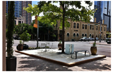
Greened streets and rail tracks Sustainability 13 14059 i002
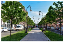
District, city and regional parks and urban meadows
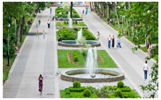
 Sustainability 13 14059 i003Green pathways Sustainability 13 14059 i004
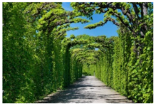
Recreational and urban green facilities Sustainability 13 14059 i005
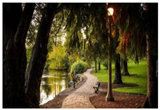
Coastal, riverside, lakeside, seaside paths, linking green and blue spaces Sustainability 13 14059 i006
Source: Open-source photos.
Table 2. Sustainability impacts of GreenPS network.
Sustainability
Pillars
GreenPS Network ImpactExamples
Society
  • Social cohesion
  • Recreational, cultural and sport activities
  • Physical and mental health
  • Sustainable mobility, social distance when necessary
Sustainability 13 14059 i007
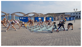
Source: http://project695285.tilda.ws/page3076798.html (accessed on 12 June 2021).
Economy
  • Small business and services activities
  • City image
  • Polycentric city development
  • Tourist business
Sustainability 13 14059 i008
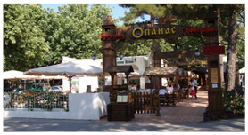
Source: https://www.na-more.su/gelen/2010/progulka.html (accessed on 12 June 2021).
Environment
  • Nature and biodiversity preservation
  • Air quality
  • Climate regulation
  • CO2 absorption
  • Noise reduction
  • Extreme events control
  • Recreation and leisure activities
  • Landscape and cultural heritage preservation
Sustainability 13 14059 i009
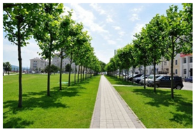
Source: https://ki-news.ru/2020/03/23/i-pust-alleya-zeleneet/amp/ (accessed on 12 June 2021).
Table 3. Calculating GreenPS sustainable indices and general integrative indicator.
IndexInDescriptionIndex Assessment
AccessibilityIARatio of maximum time cost to its regular value (15 min) I A = T A / T r e q , where
TAmaximum time cost of pedestrian access to GreenPS (isochrones data), min;
Treq.lstandard time cost of pedestrian access to GreenPS (15 min).
DensityIDNDensity coefficient0—less than 0.01
0.25—less than 0.1
0.5—from 0.1 to 0.25
0.75—from 0.25 to 0.5
1.0—not more than 0.5
SufficiencyISRatio of existing sufficiency to its norms value I S = S u f f . G r e e n P S / S n o r m , where
S u f f . G r e e n P S —present sufficiency of GreenPS, sq m/inhab.;
Snorm—standard GreenPS sufficiency, sq m/inhab.
ContinuityICRatio of the existing continuity to 100% I C = C G r e e n P S 100 , г∂e
CGreenPS—existing continuity of GreenPS, %;
Cmax—maximum project continuity—100%.
DiversityIDVDiversity coefficient0%—non-functional;
25%—mono-functional;
50%—neighborhood-scale functions integrated;
75%—city-scale functions integrated (cultural, historical and other character, tourist);
100%—regional-scale functions integrated (attracting regional economic investment).
ValueIVFlora and fauna value coefficient0%—flora and fauna no attention paid;
25%—local flora and fauna;
50%—endemic flora and fauna present;
75%—protected zones which rich biodiversity;
100%—unique flora and fauna reserves.
Clean &
Sanitary
IHHClean and sanitary supply coefficient0%—no infrastructure and equipment;
25%—inadequate infrastructure and equipment;
50%—satisfactory infrastructure and equipment;
75%—energy-efficient technologies partially integrated;
100%—infrastructure and equipment are energy efficient and technologically advanced.
Table 4. Summary data on evaluation of the existing parameters of urban GreenPS.
CityAccessibilityDensitySufficiencyContinuityDiversityValueClean and Sanitary
Regulatory/advised standard 15 min0.59–15
(for touristic cities)
100100100100
Measure unitmin-sq km/people%%%%
Sochi150.19.06510010075
Tuapse200.1950.0451007525
Yeysk300.1220.118252525
Temruk300.1243.7533755025
Armavir200.2115.852755050
Abinsk150.1262.675502525
Table 5. Summary data on GreenPS indices.
IndexAccessibilityDensitySufficiencyContinuityDiversityValueClean and SanitaryTotal
IAIDNISICIDVIVIHH I G r e e n P S  
CitySochi10.250.60.471.01.00.750.72
Tuapse0.750.751.00.451.00.750.250.71
Eysk0.50.751.00.180.750.50.250.56
Temruk0.50.51.00.330.250.250.250.44
Armavir0.750.751.00.520.750.50.50.68
Abinsk10.51.00.870.50.250.250.62
Table 6. Projected GreenPS network indices.
IndexAccessibilityDensitySufficiencyContinuityDiversityValueClean &
Sanitary
TotalChange in Comparison with Existing Values. %
CITYSochi10.50.9701.01.00.750.84+11.1
Tuapse11.01.0851.00.750.750.91+20.0
Eysk10.75 1.0851.00.50.750.84+27.4
Temruk10.5 1.0981.00.250.750.78+34.3
Armavir10.75 1.0930.750.50.750.81+13.0
Abinsk10.51.0870.750.250.750.73+10.7
Publisher’s Note: MDPI stays neutral with regard to jurisdictional claims in published maps and institutional affiliations.

