Article

A Study on Comprehensive Evaluation Methods for Coordinated Development of Water Diversion Projects Based on Advanced SWOT Analysis and Coupling Coordination Model

1
School of Water Conservancy and Hydroelectric Power, Hebei University of Engineering, Handan 056002, China
2
Hebei Key Laboratory of Smart Water Conservancy, Hebei University of Engineering, Handan 056002, China
3
Institutes of Science and Development, Chinese Academy of Sciences, Beijing 100038, China
4
China Institute of Water Resources and Hydropower Research, Beijing 100038, China
5
Handan Water Conservation Promotion Center, Handan 056002, China
*
Author to whom correspondence should be addressed.
Sustainability 2021, 13(24), 13600; https://doi.org/10.3390/su132413600
Submission received: 19 November 2021 / Revised: 1 December 2021 / Accepted: 7 December 2021 / Published: 9 December 2021
(This article belongs to the Section Sustainable Water Management)

Abstract

:
The implementation of water diversion projects will exert different influences on upstream water offering areas and the downstream water receiving areas. In order to effectively promote the coordinated development of the two regions, a comprehensive evaluation system for the coordinated development of water transfer projects has been proposed with the Middle Route of the South-to-North Water Transfer Project as the research object. The system conducts a multidimensional evaluation of social development, economic development, and ecological environmental impact, and builds a comprehensive evaluation index system with fifteen evaluation indexes at three levels, with the indexes weighted through the comprehensive weighting method based on the combination of the G1 method and the entropy weight method. Based on the degree of coordinated development among various systems, the coordinated development of the Middle Route of the South–North Water Transfer Project is graded through a comprehensive evaluation. This method is tested in the decision support system of the Middle Route Construction and Administration Bureau, China. The results show that: (1) The coupling coordination degree value of the middle route of the South-to-North Water Diversion Project is 0.8912, which shows that the regional development of the water transfer project is high coupled coordination. (2) The coordination between the economic system and the ecological environment system is weaker than the coordination between the economic system and the social service system, and the coordination between the ecological and social services is the best. Finally, based on an advanced SWOT analysis of the future development of the middle route of the South-to-North Water Diversion Project, effective suggestions for regional development are provided. It provides reference or guidance for the competent authority to manage the water diversion project and the central government to comprehensively evaluate the effectiveness of the water diversion project.

1. Introduction

Water scarcity is one of the most profound and widespread environmental challenges in the world [1,2], and the spatial distribution of water resources in China is uneven, which does not match the distribution of land and mineral resources and the distribution of productivity [3,4]. The construction of water diversion projects can alleviate the uneven distribution of water resources in space [5,6]. In March 2014, General Secretary Xi Jinping put forward the water management policy. In it, in order to achieve the goal of “balanced spatial layout” [7], it is necessary to focus on water diversion projects and water resources dispatching. At present, there are many large-scale water transfer projects in the world, some famous ones including the Colorado Great Thomson River Water Diversion Project and the South-to-North Water Diversion Project in China [8,9,10]. However, water diversion projects may cause uncoordinated development between the water offering area and the water receiving area. On the one hand, the water offering area may see its ecological environment be damaged due to the large amount of water resources diverted [11,12], and its economic and social development may be slowed down [13,14]. On the other hand, although available water in the water receiving area has increased, if we do not adhere to the high-quality economic development and regional overall coordination principles it will probably aggravate pollution [15,16] and build up the economy only in quantity rather than the quality [17,18]. Therefore, it is very important to effectively promote the coordinated development of the two areas. How to evaluate the degree of cross-regional coordinated development is a key issue.
At present, the coupling coordination model is widely used in social [19,20], economic and environmental aspects, including river and lake health assessment. Take the middle and lower reaches of the Hanjiang River as an example, the river ecosystem health assessment system is constructed based on indexes of integrity, stability, and sustainability [21]. Another study focuses on the evaluation of coordinated development for Dongting Lake by building a systematic ecology–economy–society evaluation model of coordinated development, and the coupling degree and coordinated development degree of Dongting Lake system in 14 years from 2005 to 2018 are measured quantitatively [22]. The evaluation of coordinated development is made based on statistics of seven cities by the East China Sea by building an economy–society–environment evaluation model of coordinated development, and its comprehensive development level and coupling coordination degree are analyzed and predicted through the R/S analysis method [23]. Therefore, it is feasible to use the coupling coordination model to evaluate the overall development of the Middle Route of the South–North Water Transfer Project [24]. In addition, the index system established in this paper is not only suitable for academic research, but also provides support for the authorities to manage water diversion projects and for the central government to carry out a comprehensive evaluation of the effectiveness of water diversion projects. However, the current research does not consider the coordinated development among various systems, nor does it consider the classification of coordinated development of water transfer projects.
Previously, the SWOT method has been applied in studies for solving urban ecological crises [25,26], and a model of urban ecological footprint and ecological capacity was established to analyze the ecological sustainability of regional tourism environment before putting forward the strategy of sustainable development [27]. Besides, SWOT analysis, fuzzy theory, and the ANP method [28] were used to conclude that making a consumer awareness plan is the best strategy. SWOT analysis and the fuzzy analytic hierarchy process (FAHP) were used to evaluate the potential of renewable resources in a certain area of Pakistan, and it was concluded that the government needs to develop renewable resources, making it the best strategy to alleviate the energy crisis in Pakistan [29]. Therefore, it is feasible to use the SWOT method to give strategy options on how to promote regional coordinated development after completion of the Middle Route of the South–North Water Transfer Project.
The comprehensive evaluation method for the coordinated development of the Middle Route of the South-to-North Water Transfer Project was explored, and a comprehensive evaluation process for the coordinated development of the project was proposed. Our work goals are: (1) establish a multi-index system for social development, economic and ecological environmental impact; (2) use the G1 method and entropy weight method to determine the weight of each index; (3) establish a comprehensive evaluation system based on the comprehensive evaluation method for the coupled and coordinated development of water transfer projects; (4) verify the rationality of the method through examples; (5) use SWOT analysis to put forward effective suggestions for regional development; (6) discuss the advantages and disadvantages of this method.

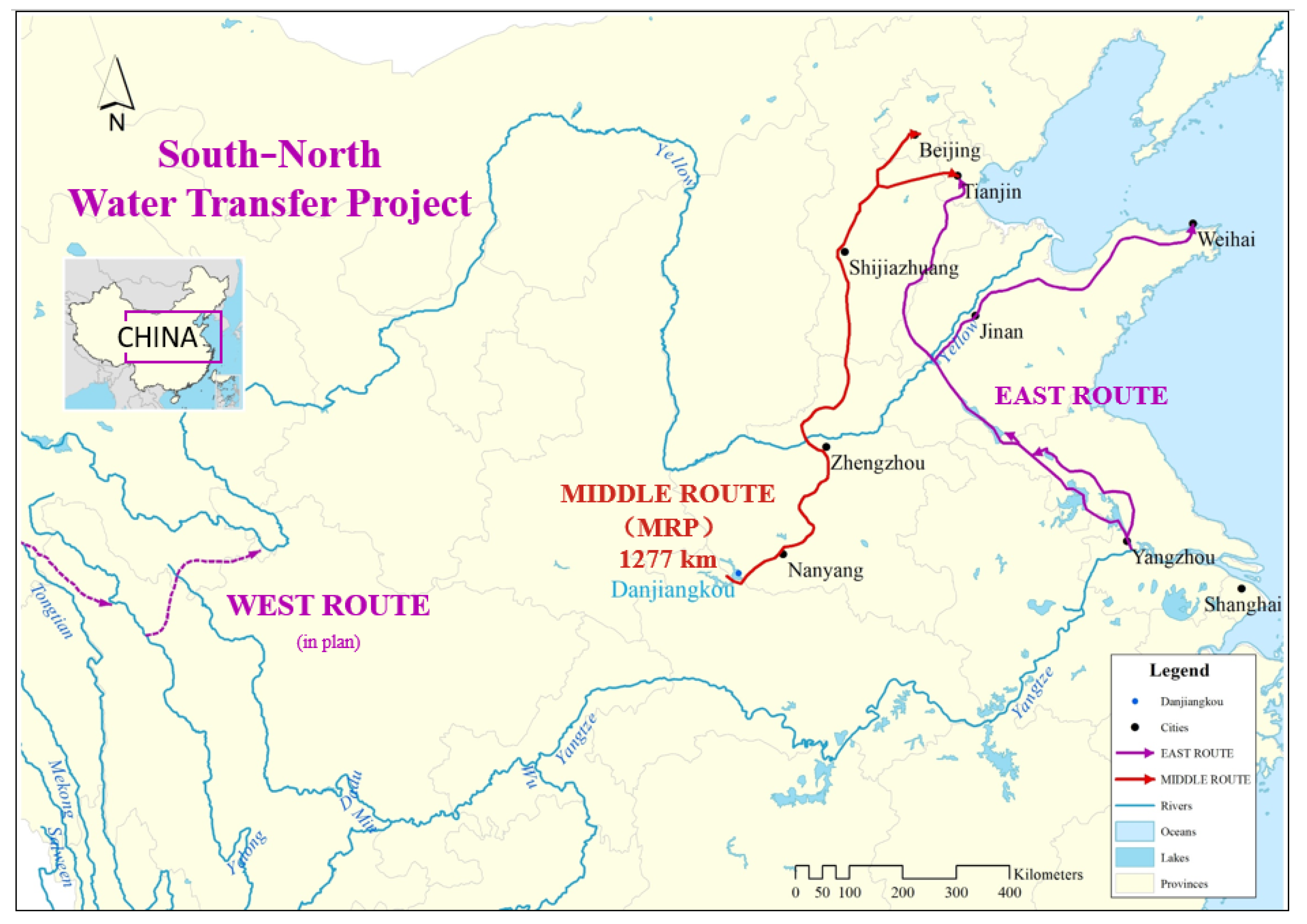
2. Overview of the Area Studied

The Middle Route of the South–North Water Transfer Project is proposed to meet the development needs of all parts of North China (Figure 1). This project passes through the west side of the third step of China’s topography and draws water from the middle reaches of the Yangtze River and its tributary Hanjiang River, which can supply water to most areas of the Huang-Huai-Hai Plain by gravity. During the near term, water has been diverted from Danjiangkou Reservoir along the Hanjiang River, a tributary of the Yangtze River, and channeled along the piedmont plain of Funiu Mountain and Taihang Mountain before ending in Beijing. In the long-term, it is planned to divert water from the Three Gorges Reservoir or the main stream of the Yangtze River below to increase the amount of water diverted to the north. The Middle Route of the South–North Water Transfer Project has good water quality, large coverage, self-flowing water transfer, and other advantages. This project is planned to divert 14.6 billion m³ of water from Danjiang Reservoir annually, which mainly supplies water to Hubei, Henan, Hebei, Beijing, and Tianjin in the Tangbai River Basin, the middle and upper reaches of Huaihe River, and the western plain of Haihe River Basin. It focuses on solving the water shortage situation of more than 20 large and medium-sized cities along the diverting route such as Beijing, Tianjin, and Shijiazhuang, and takes into account the ecological environment and agricultural water use all along, which is a major solution to the water resources crisis in North China [30].

3. Comprehensive Evaluation Method for Coordinated Development of the Middle Route of the South–North Water Transfer Project

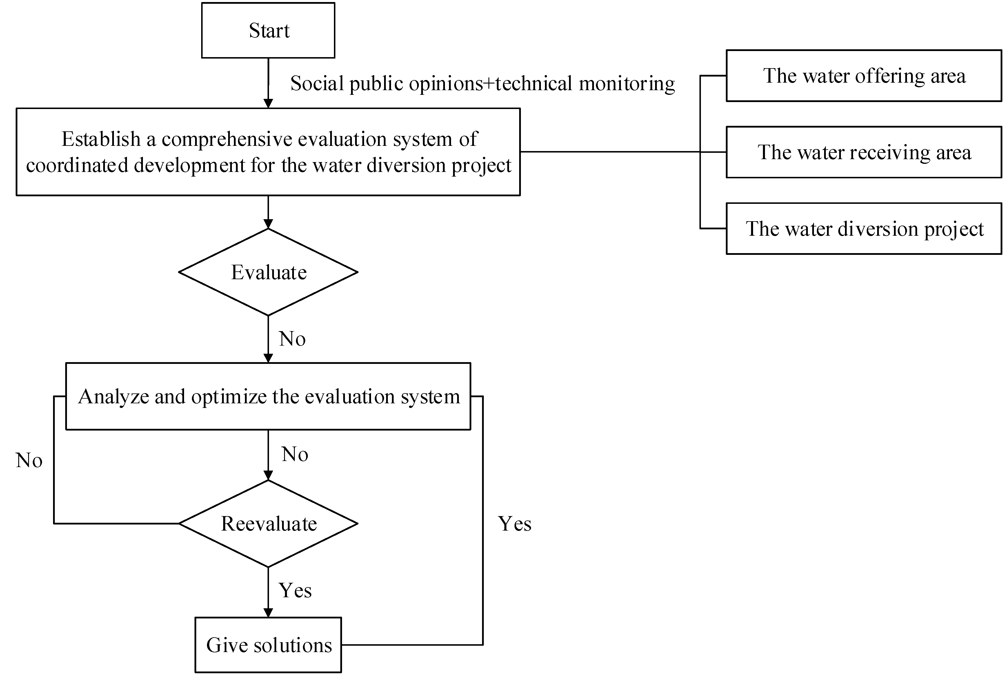
3.1. Evaluation Process

The Middle Route of the South–North Water Transfer Project will have an impact on the economy, ecology, and society of the water offering area and the water receiving area. In order to comprehensively analyze the contribution that water supply makes to social development, economic development, and ecological environment in the Middle Route of the South–North Water Transfer Project, and further improve the public recognition of this project, it is of great significance to establish a comprehensive evaluation system for the coordinated development of the water offering area and the water receiving area.
The comprehensive evaluation process of coordinated development of the Middle Route of the South–North Water Transfer Project is shown in Figure 2.
The first step is to collect information and data related to water offering areas, water receiving areas, and the water diversion project through literature research, field investigations, network queries, and technical monitoring.
The second step is to calculate the index with data collected by using the comprehensive evaluation system of coordinated development for the Middle Route of the South–North Water Transfer Project and evaluate the results to judge whether they show coordinated development or not: if coordinated, the evaluation is completed; if not coordinated, proceed to the third step.
The third step is to analyze the whole area and take measures to optimize it by relevant authorities, then collect information and data of the adjusted whole area after the optimization is completed and repeat the second step to calculate through the comprehensive evaluation system for the coordinated development of the Middle Route of the South–North Water Transfer Project to judge whether the evaluation results are coordinated. If it is still not coordinated, repeat the above process to continuously analyze and optimize until the evaluation results prove coordinated and the evaluation is completed.

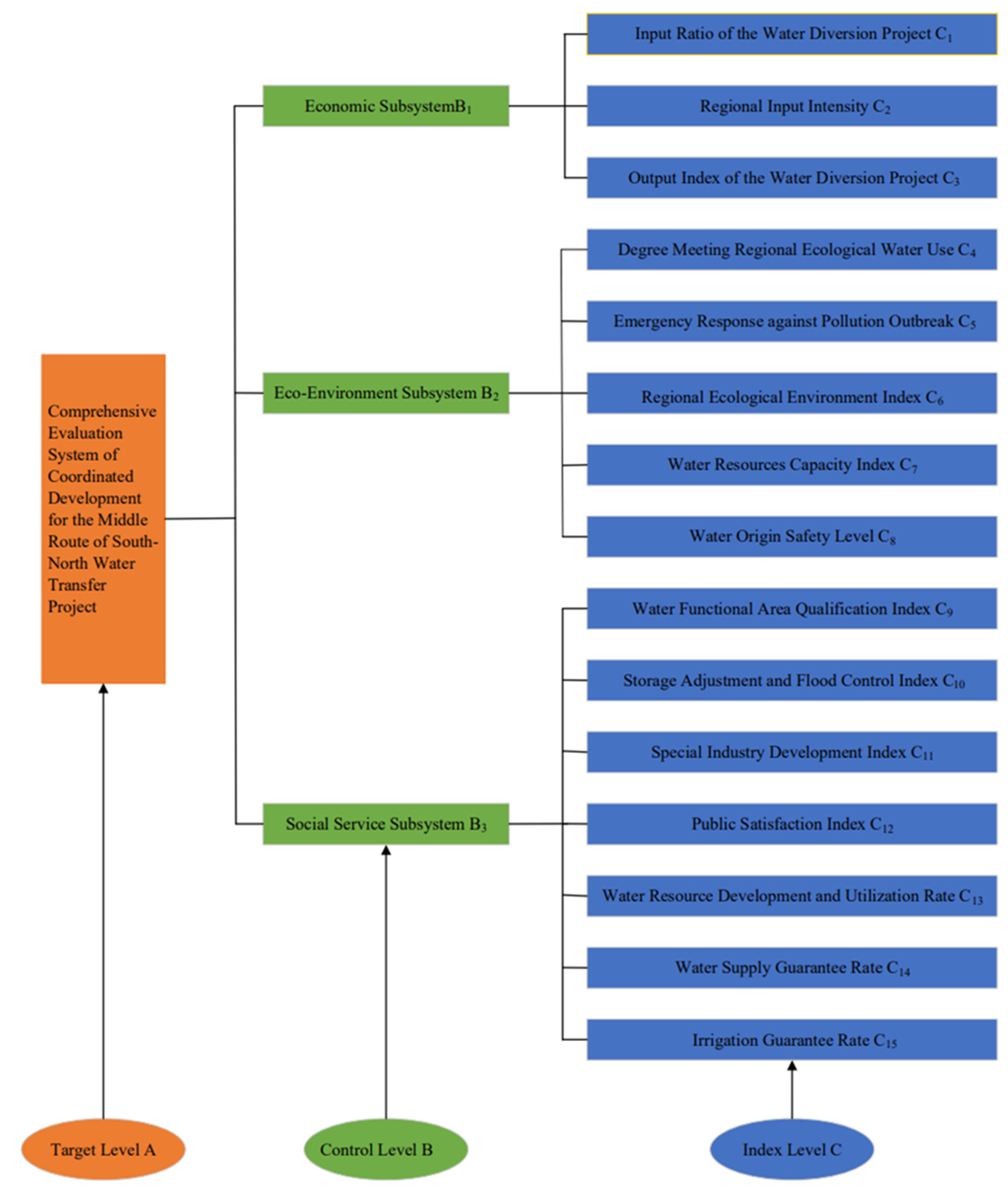
3.2. Establish a Comprehensive Evaluation System of Coordinated Development for the Middle Route of the South–North Water Transfer Project

3.2.1. Define the Comprehensive Evaluation System of Coordinated Development

Principles for Defining the Indexes

(1)
Representative principle: the selected indicators should fully reflect the overall features of the economy, ecological environment, and social services of water diversion projects.
(2)
Systematic principle: there are internal and external links among the selected indexes. Namely, there is a logical relationship inherent to these indexes, and superficially they also reflect the economy–ecological environment–social service system.
(3)
Practical principle: The operability analysis of evaluation indicators has the following requirements: ① availability of information and data; ② low impact on managerial costs; ③ meet the economic needs of coordinated development of the two areas; ④ meet the ecological and environmental needs for the coordinated development of the two areas; ⑤ meet the social service needs for the coordinated development of the two areas. This index evaluation system requires that indexes have strong applicability, namely meeting the criteria of ① and ② and at least one of the three criteria of ③ to ⑤.
(4)
Dynamic principle: The study of the eco-environment–economy–society system is a dynamic process, where its development potential needs to be investigated dynamically, so it is necessary to collect index data for years to determine the changes.

Define the Index System

The Middle Route of the South–North Water Transfer Project is a complex system integrating social services, ecological environment, and economic development, with the subsystems interacting and check and balancing with each other. Based on the above-mentioned principles for defining indexes, this paper selects 15 strongly applicable and highly representative key indicators from the perspectives of geographical location, pollutant type, economic impact, ecological environment impact, and social service function to establish a comprehensive, flexible, and easy-to-quantify evaluation index system of coordinated development for the Middle Route of the South–North Water Transfer Project, as shown in Figure 3.

3.2.2. Define the Value of Each Index

The evaluation index system of coordinated development for the Middle Route of the South–North Water Transfer Project identifies fifteen indexes from three aspects of economy, social services, and ecological environment. According to their contribution to regional coordinated development, the indicators can be divided into positive indicators and negative indicators. The greater the positive index value is, the more conducive it is to regional coordinated development, while the contrary is a negative index. The following method is given to define the value of each index, which can further determine the coordinated development degree of this project.

Define the Value of Economic Subsystem Indexes

There are three indicators in the economic subsystem: Input Ratio of the Water Diversion Project, Regional Input Intensity, and Output Index of the Water Diversion Project. The calculation formula of each index in the economic subsystem is shown in Table 1, and the description of the calculation variables of each indicator are shown in Table S1 (electronic supplementary material).

Define the Value of Eco-Environment Subsystem Indexes

There are five indicators in the eco-environment subsystem: Degree Meeting Regional Ecological Water Use, Emergency Response against Pollution Outbreak, Regional Ecological Environment Index, Water Resources Capacity Index, and Water Origin Safety Level. The calculation formula of each index in the eco-environment subsystem is shown in Table 2, and the description of the calculation variables of each indicator are shown in Table S2 (electronic supplementary material).

Define the Value of Social Service Subsystem Indexes

In the social service subsystem, there are seven indicators: Water Functional Area Qualification Index, Storage Adjustment and Flood Control Index, Special Industry Development Index, Public Satisfaction Index, Water Resource Development and Utilization Rate, Water Supply Guarantee Rate, and Irrigation Guarantee Rate. The calculation formula of each index in the social service subsystem is shown in Table 3, and the description of the calculation variables of each indicator are shown in Table S3 (electronic supplementary material).
Indicator values of C1, C2, C3, C4, and C10 may be greater than 1. In order to eliminate the impact caused by different orders of magnitude of data, values of these five indicators are assigned, as shown in Table 4.

3.2.3. Define the Weight of Each Index

In this paper, a comprehensive and integrated weighting method [31] is used, which combines the advantages of the subjective weighting method and the objective one. By comparing the weight vectors obtained by subjective and objective methods, the deviation of a specific index can be minimized, thus combining the advantages of both methods.

The Subjective Weighting Method

Among many subjective weighting methods, the G1 method does not need to make matrix consistency judgments or conduct consistency tests [32,33]; the adjustment process dominated by experts’ will fully reflect subjectivity, and the calculation process is concise, clear, and explicit. Therefore, this paper chooses the G1 method as the subjective weighting method. Its calculation steps are illustrated as follows.
A. When m policy-makers’ order relationships are consistent:
Firstly, define the order relationship: namely under the premise of a certain evaluation criterion, the order relationship of the evaluation indicators is determined by the importance of the evaluation indicators, and finally, a relationship sequence is obtained: x1 > x2 >…> xn.
Then, the comparative judgment of the relative importance between xk−1 and xk is given:
w k 1 w k = r k   k = n ,   n 1 ,   n 2 ,   ,   2 .
For value assignment for rk, refer to Table 5.
Finally, calculate the index weight coefficient:
w n = ( 1 + k = 2 n i = k n r i ) 1
w k 1 = r k w k , k = n , n 1 , , 2
When m policy-makers’ order relationships are inconsistent:
Assuming that there are P types of order relationship, the number of experts is M1, M2,…, MP, it is sufficed
i = 1 P M i = m . Then the weight for each type of order relationship is w j i ( i = 1 , 2 , , P ; j = 1 , 2 , , n ) .
The coefficient for each index’s weight is
w j = M 1 m w j 1 + M 2 m w j 2 + + M P m w j P , j = 1 , 2 , , n .

The Objective Weighting Method

The entropy method follows mathematical laws, and information comes from the original data in each system, which fully demonstrates the scientific and objective features of the objective weighting method. Therefore, this paper chooses the entropy method as an objective weighting method [35,36]. Its calculation steps are illustrated as follows.
Firstly, it is assumed that there are m objects to be evaluated and n evaluation indexes. For the i-th target scheme, the formula for calculating the evaluated weight pij of the j-th index is as follows:
P i j = r i j / i = 1 m r i j
Then, calculate the entropy value of the j-th index:
e j = k i = 1 m p i j ln p i j
In which k = 1 / ln m .
Finally, calculate the entropy weight of the j-th index:
w j = ( 1 e j ) / j = 1 n ( 1 e j )

The Comprehensive Integrated Weighting Method

In this paper, both the subjective method and the objective method are used to weight n indexes respectively, and two index weight vectors are obtained:
w ( k ) = [ w k 1 , w k 2 , , w k n ] , k = 1 , 2
The arbitrary linear combination of these two weight vectors is:
w = k = 1 2 a k w ( k ) , a k > 0
In the formula, ak is the linear combination coefficient; w is the comprehensive weighting vector set.
The two linear combination coefficients ak in Formula (7) are optimized to minimize the deviation between w and each wk. It can be concluded that:
j = 1 2 a j w j w j T = w i w i T , i = 1 , 2
(a1, a2) calculated by Formula (8) is then normalized, namely
a k = a k / k = 1 2 a k
The final combination weight is:
w * = k = 1 2 a k * w ( k )

3.2.4. Define the Coordinated Development Level

Coupling, derived from physics, refers to the phenomenon that two or more systems or motion forms influence each other through various interactions. Introducing the coupling coordination model into the study can not only reflect the coordination between the economy–ecological environment–social service systems, but also demonstrate the stage of coordinated development, namely:
(1)
Calculate the comprehensive evaluation index of three systems f(x), g(y), k(m):
f ( x ) = x = 1 3 ω x C x , g ( y ) = y = 4 8 ω y C y , k ( m ) = m = 9 15 ω m C m
In the formula, f(x) represents the comprehensive evaluation function of the economic subsystem, g(y) represents the comprehensive evaluation function of the ecological environment subsystem, and k(m) represents the comprehensive evaluation function of the social service subsystem; ωx, ωy, and ωm respectively represent the weight of each index of the economic subsystem, the ecological environment subsystem, and the social service subsystem.; x,y,m respectively are the total number of indexes in each system; C is the indicator value.
(2)
Calculate the coupling coordination degree:
With the help of the coupling coordination model, the economy–ecological environment–social service system coupling degree O, the coupling coordination degree D, and the comprehensive evaluation index M of the regional economy–ecological environment–social service system are obtained:
O = { f ( x ) × g ( y ) × k ( m ) [ ( f ( x ) + g ( y ) + k ( m ) ) / 3 ] 3 } 1 / 3
D = O × M
M = a f ( x ) + b g ( y ) + c k ( m )
In the formula, a, b, and c are undetermined coefficients, and the weights of the three subsystems can be calculated as undetermined coefficients by the comprehensive weighting method.
See Table 6 for classification and evaluation criteria of coordinated development level.

4. Application Discussion and Analysis Suggestions

4.1. Application Discussion

(1)
Application
The construction and development of the middle route of the South-to-North Water Diversion Project has always attracted national attention. With the rise of smart cities, smart water diversion projects are also emerging quietly. In recent years, the national investment in the information construction of water diversion projects has increased, far exceeding the previous budget. At the same time, due to the short operation time of the South-to-North Water Transfer Project, the output index is relatively low, so the index values in the economic subsystem are shown in Table 7. Since September 2017, 47 rivers in northern China have been replenished with ecological water by the middle route project, and the total amount of water replenished has reached 5.39 billion m3. Among them, 3.32 billion m3 has been replenished by the pilot river section of the comprehensive control of groundwater overdrawing in North China, with significant ecological and environmental benefits. The index values in the eco-environment subsystem are relatively good (Table 7). Since the opening of the project, the South-to-North Water Diversion Project has become the main source of water in large and medium-sized urban areas along the Beijing-Tianjin-Hebei and Henan routes, benefiting a growing number of people year after year. It fundamentally changes the water supply pattern in the water receiving area, improves the water quality of the city, and improves the water supply guarantee rate in the water receiving area along the line. The indicators of the social service subsystem are relatively good (Table 7). The weight of each index in Table 7 can be calculated according to Equations (1)–(10) for weight calculation.
According to Equations (11)–(14), the calculated values of O, D, and M are as follows.
O = 0.998 M = 0.7958 D = 0.8912
Based on Table 6, at present, the coordination of the middle route of the South-to-North Water Diversion Project is high coupled coordination.
(2)
Discussion
This paper proposes a comprehensive evaluation method for the coordinated development of water transfer projects based on the coupled coordination model. The comprehensive weighting method that combines the G1 method and the entropy weight method avoids the impact of the small amount of observation data and coordinates the impact of subjective and objective factors on the index weight so that the weight of each index conforms to common sense and has a scientific basis. The introduction of the coupling coordination model can realize the dynamic relationship between the three subsystems of coordinated economy, ecological environment, and social services, and can also reflect the degree of interdependence and mutual restriction between the systems.
The coordination degree model is introduced to analyze the coordination relationship between different subsystems. The specific calculation formulas are as follows.
E 1 = ( f ( x ) g ( y ) / [ f ( x ) + g ( y ) 2 ] 2 ) 2
E 2 = ( f ( x ) k ( m ) / [ f ( x ) + k ( m ) 2 ] 2 ) 2
E 3 = ( k ( m ) g ( y ) / [ k ( m ) + g ( y ) 2 ] 2 ) 2
T 1 = x = 1 3 ω x f ( x ) + y = 4 8 ω y g ( y ) , T 2 = x = 1 3 ω x f ( x ) + m = 9 15 ω m k ( m ) , T 3 = y = 4 8 ω y g ( y ) + m = 9 15 ω m k ( m )
F i = E i T i , i = 1 , 2 , 3
In the formula, E1, E2, and E3 respectively represent the coordination degree between economy and ecological environment, economic and social services, ecological environment and social services; F represents the degree of coordinated development.
According to the calculation formulas Equation (11), Equations (15)–(17), and Table 7, the coordination degree between the economy and the ecological environment, economic and social services, and the ecological environment and social services are calculated respectively. According to Formulas (19) and (20), the coordinated development degree between the economy and the ecological environment, the economy and social services, and the ecological and social services can be calculated, and the coordinated relationship between the two systems can be quantitatively analyzed. The results are as follows.
F1 = 0.246 F2 = 0.224 F3 = 0.171
The larger the F value, the worse the coordination between the two systems. The coordination between the economic system and the ecological environment system is weaker than the coordination between the economic system and the social service system, and the coordination between the ecological and social services is the best. Because the improvement of the ecological environment requires abandoning part of the economic development, and the improvement of the quality of social services also requires a certain amount of economic input, there are conflicting relations between the economic system and the ecological environment system, and the economic system and the social service system. Therefore, the coordination between the economic system and the ecological environment system, the economic system, and the social service system is not as good as the coordination between the ecological and social services.

4.2. Analysis Suggestion

According to the coordination between the three subsystems, using SWOT analysis, combined with the actual situation, suggestions for the coordinated development of water transfer projects are given.
SWOT analysis (S for strengths, W for weaknesses, O for opportunities, and T for threats) is a situation analysis based on internal and external environmental and competition conditions, in which process various main internal strengths, weaknesses, and external opportunities and threats closely related to the research object are listed through investigation and arranged in the form of a matrix and then all kinds of factors are matched and analyzed with system analysis, thus drawing a series of corresponding conclusions for decision-making. The contribution of SWOT lies in matching these seemingly independent factors for comprehensive analysis, which makes strategic planning more scientific and comprehensive. However, in the process of SWOT analysis, you may encounter some problems, which can be solved by the more advanced POWER SWOT analysis. POWER is the acronym for Personal Experience, Order, Weighting, Empathize detail, and Rank and prioritize, which is also called advanced SWOT analysis.
Based on the advanced SWOT analysis method, this paper evaluates the degree of regional coordinated development after the completion of the Middle Route of the South–North Water Transfer Project, and the evaluation results are shown in Table 8. It can be seen from Table 6 that the internal advantages of the project are well played and bring many opportunities for regional development; the implementation of the water diversion project reduces the unreasonable structure in original regional resources distribution, drives the economic development and environmental improvement of the whole water offering area, and makes great contributions to society. Based on the recommendations of the advanced SWOT analysis results (Table 8), it is concluded: (1) SO (Strengths and Opportunities): the Middle Route of the South–North Water Transfer Project can vigorously boost ecotourism in water source areas, improve the coordinated development mechanism of water source protection areas, and play a role in strengthening water quality management along the route; (2) WO (Weaknesses and Opportunities): carry out ecological restoration plans in the water receiving area and plan the overall urban water system; support green eco-economy in water source areas and promote the industrial transformation and upgrading of water source areas; (3) ST (Strengths and Threats): it is necessary to establish a sound guarantee system and evaluation system, improve managerial ability, optimize the environment to attract investment, and increase the protection of groundwater in the water offering area; (4) WT (Weaknesses and Threats): to establish a reasonable ecological compensation mechanism for water source areas, the water receiving areas need to bear the costs, improve the water resources management system, enhance water-resource utilization efficiency, intensify publicity of water-saving knowledge, and raise people’s awareness of water-saving. Based on the results of advanced SWOT analysis, the paper gives some detailed suggestions (Table 9), which are more conducive to the future development of the project.

5. Conclusions

A comprehensive evaluation process for the coordinated development of water transfer projects is proposed. The main conclusions are as follows:
(1)
In accordance with the principles of representativeness, systematicness, pragmatism, and dynamics, 15 evaluation indicators were selected to establish an indicator system. These reflect the relationship between economy, ecological environment, and social services.
(2)
A subjective and objective comprehensive weighting method based on the G1 method and entropy weight method is proposed. The key of this method is to combine the entropy method which considers the objective attributes of the data and the analytic hierarchy process which considers the subjective characteristics of the data, and the final index weights are more reasonable.
(3)
The coupling coordination degree model is introduced, and a comprehensive evaluation system for the coordinated development of water transfer projects based on the comprehensive weighting method is proposed.
(4)
Apply the comprehensive evaluation method to the coordinated development evaluation of the Middle Route of the South-to-North Water Transfer Project. The results show that the regional development of the water transfer project is high coupled coordination. The coordination between the economic system and the ecological environment system is weaker than the coordination between the economic system and the social service system, and the coordination between the ecological and social services is the best. The research results provide a new method for the evaluation of the coordinated development of water transfer projects.
(5)
Use SWOT analysis on the water receiving area and water transfer area of the Middle Route of the South-to-North Water Transfer Project, and put forward feasible suggestions for the relevant departments on the governance of the water receiving area and water transfer area.
(6)
Through a series of analyses we can conclude that this research method makes up for the deficiencies of previous methods. It integrates three aspects of the economy, ecological environment, and social services, and has the advantages of simplicity and thoroughness. This paper proposes a comprehensive evaluation process for the successful coordinated development of water transfer projects.
(7)
It also puts forward the direction of future research: Although the relationship between economy, ecological environment, and social services is considered, the index system is still imperfectly scientific and reasonable. Therefore, the establishment of a more comprehensive indicator system provides a possible way for future research.

Supplementary Materials

The following are available online at https://www.mdpi.com/article/10.3390/su132413600/s1. Table S1: The description of the calculation variables of each indicator; Table S2: The description of the calculation variables of each indicator; Table S3: The description of the calculation variables of each indicator.

Author Contributions

Conceptualization, Y.L. (Yan Long) and Y.L. (Youming Li); methodology, Y.L. (Yan Long); software, Y.L. (Youming Li); validation, Y.L. (Yan Long), Y.L. (Youming Li) and S.G.; formal analysis, J.S.; investigation, S.G.; resources, J.S.; data curation, Yan Long.; writing—original draft preparation, S.G.; writing—review and editing, Y.L. (Youming Li); visualization, X.L.; supervision, Y.H.; project administration, X.L.; funding acquisition, Y.H. All authors have read and agreed to the published version of the manuscript.

Funding

National Natural Science Youth Fund 52009026; The National Natural Science Foundation of Hebei Province E2021402039.

Institutional Review Board Statement

This statement if the study did not involve humans or animals.

Informed Consent Statement

Informed consent was obtained from all subjects involved in the study.

Data Availability Statement

All data, models, and code generated or used during the study appear in the submitted article.

Conflicts of Interest

The authors declare that they have no known competing financial interest or personal relationships that could have appeared to influence the work reported in this paper.

References

  1. Lou, Y.; Xiao, Y.; Hao, Q.; Zhang, Y.; Zhao, Z.; Wang, S.; Dong, G. Groundwater geochemical signatures and implication for sustainable development in a typical endorheic watershed on Tibetan plateau. Environ. Sci. Pollut. Res. 2021, 28, 48312–48329. [Google Scholar] [CrossRef]
  2. Xiao, Y.; Hao, Q.; Zhang, Y.; Zhu, Y.; Yin, S.; Qin, L.; Li, X. Investigating sources, driving forces and potential health risks of nitrate and fluoride in groundwater of a typical alluvial fan plain. Sci. Total Environ. 2022, 802, 149909. [Google Scholar] [CrossRef] [PubMed]
  3. Jia, Y.; Shen, J.; Wang, H.; Dong, G.; Sun, F. Evaluation of the Spatiotemporal Variation of Sustainable Utilization of Water Resources: Case Study from Henan Province (China). Water 2018, 10, 554. [Google Scholar] [CrossRef] [Green Version]
  4. Yin, Y.Y.; Wang, L.; Wang, Z.J.; Tang, Q.; Piao, S.; Chen, D.; Xia, J.; Conradt, T.; Liu, J.; Wada, Y.; et al. Quantifying Water Scarcity in Northern China within the Context of Climatic and Societal Changes and South-to-North Water Diversion. Earth Future 2020, 8, 17. [Google Scholar] [CrossRef]
  5. Hong, S.; Song, Z.; Cheng, T.; Wang, H. Spatial matching analysis of water resources in the intake area of South-North Water Transfer Project based on Gini coefficient. J. Beijing Norm. Univ. Nat. Sci. 2017, 53, 175–179. [Google Scholar] [CrossRef]
  6. Zhu, T.; Wang, N.X. Analysis on Development Strategy of Archive Management in South-to-North Water Transfer Project. South-North Water Transf. Water Sci. Technol. 2009, 7, 4–6. [Google Scholar] [CrossRef]
  7. Zuo, Q.; Han, C.; Ma, J. Application rules and quantification methods of water resources spatial equilibrium theory. Hydro-Sci. Eng. 2019, 6, 50–58. [Google Scholar] [CrossRef]
  8. Gastelum, J.R.; Cullom, C. Application of the Colorado River Simulation System Model to Evaluate Water Shortage Conditions in the Central Arizona Project. Water Resour. Manag. 2013, 27, 2369–2389. [Google Scholar] [CrossRef]
  9. Karwacki, P. The Kipawa River versus the Tabaret River diversion projects. Appl. Energy 2003, 75, 221–233. [Google Scholar] [CrossRef]
  10. Liang, S.; Richard, G.; Zhu, L.; Sun, W.; Cui, Q. Global large-scale inter-basin water transfer projects and potential of water resources’ agricultural development. J. Water Resour. Water Eng. 2019, 30, 236–246. [Google Scholar] [CrossRef]
  11. Feng, D.; Zhao, G. Footprint assessments on organic farming to improve ecological safety in the water source areas of the South-to-North Water Diversion project. J. Clean. Prod. 2020, 254, 120130. [Google Scholar] [CrossRef]
  12. Zhao, P.; Li, Z.; Zhang, R.; Pan, J.; Liu, Y. Does water diversion project deteriorate the water quality of reservoir and downstream? A case-study in Danjiangkou reservoir. Glob. Ecol. Conserv. 2020, 24, e01235. [Google Scholar] [CrossRef]
  13. Gao, W.; Zeng, Y.; Liu, Y.; Wu, B. Human Activity Intensity Assessment by Remote Sensing in the Water Source Area of the Middle Route of the South-to-North Water Diversion Project in China. Sustainability 2019, 11, 5670. [Google Scholar] [CrossRef] [Green Version]
  14. Chan, X.; Ping, X.; Tao, T.; Li, C. Comprehensive evaluation of the influence of Middle Route of South-to-North Water Diversion Project on the water source in Shaanxi. J. Northwest Univ. Nat. Sci. Ed. 2009, 39, 1075–1079. [Google Scholar]
  15. Wang, S.; Zhu, Z.; Tao, X. Economic Impact Assessment of Middle Route of South-to-North Water Diversion Project on Water Source Area in Henan Province Based on Uncertain AHP Method. South-North Water Transf. Water Sci. Technol. 2011, 9, 17–20. [Google Scholar] [CrossRef]
  16. Wei, Y.; Zhang, K.; Zhang, B. Effects of Water Pollutant Emission Standard in Watersheds of South-to-North Water Diversion Project on Economy of Cities along the Water Transfer Line in Shandong Province. South-North Water Divers. Water Sci. Technol. 2013, 11, 81–85. [Google Scholar] [CrossRef]
  17. Peng, Z.Y.; Yin, J.X.; Zhang, L.L.; Zhao, J.; Liang, Y.; Wang, H. Assessment of the Socio-Economic Impact of a Water Diversion Project for a Water-Receiving Area. Pol. J. Environ. Stud. 2020, 29, 1771–1784. [Google Scholar] [CrossRef]
  18. Wang, B.W.; Feng, Y.; Wang, Y.N.; Yao, S.B. SWOT analysis on tourist eco-footprint and ecological carrying capacity in poverty-stricken areas. Environ. Eng. Manag. J. 2020, 19, 1481–1489. [Google Scholar]
  19. Xiong, X.; Xiao, J. Evaluation of coupling coordination between urbanization and eco-environment in six central cities, Wuling Mountain area. Acta Ecol. Sin. 2021, 41, 5973–5987. [Google Scholar] [CrossRef]
  20. Zhao, L.; Li, L.; Wu, Y. Research on the Coupling Coordination of a Sea-Land System Based on an Integrated Approach and New Evaluation Index System: A Case Study in Hainan Province, China. Sustainability 2017, 9, 859. [Google Scholar] [CrossRef] [Green Version]
  21. Su, Y.; Li, W.; Ai, Z.; Liu, D.; Zhu, C.; Li, J.; Sun, X. Establishment and application of the index system for health assessment of the middle and lower reaches of the Hanjiang River. Acta Ecol. Sin. 2019, 39, 3895–3907. [Google Scholar] [CrossRef]
  22. Wu, Y.; Luo, H.; Li, Y.; Wang, Y. Influence mechanism of spatial-temporal differentiation of the coupling and coordinated development of ecology-economy-society system in dongting lake area. Fresenius Environ. Bull. 2021, 30, 1756–1763. [Google Scholar]
  23. Zhang, X.; Wu, J.; Liu, J.; Liu, L. Coupling Coordinative Development Model of the Economy-Society-Environment System in Some Coastal Cities of the East China Sea. Pol. J. Environ. Stud. 2021, 30, 943–954. [Google Scholar] [CrossRef]
  24. Long, Y.; Xu, G.; Ma, C.; Chen, L. Emergency control system based on the analytical hierarchy process and coordinated development degree model for sudden water pollution accidents in the Middle Route of the South-to-North Water Transfer Project in China. Environ. Sci. Pollut. Res. 2016, 23, 12332–12342. [Google Scholar] [CrossRef] [PubMed]
  25. Ryu, J.-H. Exploring the SWOT Strategy of Busan Metropolitan Government with the SWOT Analysis. Korean Local Gov. Rev. 2008, 9, 25–48. [Google Scholar]
  26. Son, Y.-J. A Study on the Development Strategy of Gwangyang Port Using the SWOT/AHP Analysis. J. Korea Port Econ. Assoc. 2011, 27, 247–262. [Google Scholar]
  27. Wang, K.; Wang, Z.; Liu, K.; Cheng, L.; Wang, L.; Ye, A. Impacts of the eastern route of the South-to-North Water Diversion Project emergency operation on flooding and drainage in water-receiving areas: An empirical case in China. Nat. Hazards Earth Syst. Sci. 2019, 19, 555–570. [Google Scholar] [CrossRef] [Green Version]
  28. Aghasafari, H.; Karbasi, A.; Mohammadi, H.; Calisti, R. Determination of the best strategies for development of organic farming: A SWOT—Fuzzy Analytic Network Process approach. J. Clean. Prod. 2020, 277, 124039. [Google Scholar] [CrossRef]
  29. Wang, Y.; Xu, L.; Solangi, Y.A. Strategic renewable energy resources selection for Pakistan: Based on SWOT-Fuzzy AHP approach. Sustain. Cities Soc. 2020, 52, 101861. [Google Scholar] [CrossRef]
  30. Zhang, Z. Middle Route of South-to-North Water Transfer Project and Sustainable Development of Regional Economy. J. Anhui Agric. Sci. 2007, 35, 9373–9385. [Google Scholar] [CrossRef]
  31. Xu, H.; Ma, C.; Lian, J.; Xu, K.; Chaima, E. Urban flooding risk assessment based on an integrated k-means cluster algorithm and improved entropy weight method in the region of Haikou, China. J. Hydrol. 2018, 563, 975–986. [Google Scholar] [CrossRef]
  32. Zhang, F.; Guo, Y.; Tao, Y. Multi-phase interactive group evaluation method based on rank correlation analysis. J. Syst. Eng. 2011, 26, 702–709. [Google Scholar] [CrossRef]
  33. Pratt, B.; Chang, H. Effects of land cover, topography, and built structure on seasonal water quality at multiple spatial scales. J. Hazard. Mater. 2012, 209, 48–58. [Google Scholar] [CrossRef] [PubMed]
  34. Yu, D.; Lv, L.; Meng, F.; Gao, F.; He, J.; Zhang, L.; Li, Y. Landslide risk assessment based on combination weighting-improved TOPSIS. IOP Conf. Ser. Earth Environ. Sci. 2021, 769, 032022. [Google Scholar] [CrossRef]
  35. Bahreini, F.; Soltanian, A.R. Identification of a Gene Set Associated with Colorectal Cancer in Microarray Data Using the Entropy Method. Cell J. 2019, 20, 569–575. [Google Scholar] [CrossRef] [PubMed]
  36. Yuan, Z.; Zhang, X.; Feng, S. Hybrid data-driven outlier detection based on neighborhood information entropy and its developmental measures. Expert Syst. Appl. 2018, 112, 243–257. [Google Scholar] [CrossRef]
Figure 1. Schematic diagram of the Middle Route of the South–North Water Transfer Project.
Sustainability 13 13600 g001
Figure 2. Flow chart of the comprehensive evaluation of coordinated development for the Middle Route of the South–North Water Transfer Project.
Sustainability 13 13600 g002
Figure 3. Evaluation index system of coordinated development for the Middle Route of the South–North Water Transfer Project.
Sustainability 13 13600 g003
Table 1. Calculation formula of each index in the economic subsystem.
IndexCalculation FormulaIndex AttributeNotes
Input Ratio of the Water Diversion Project C1 C 1 = P I / B G = i = 1 6 P I i / 191.25 NegativeIn which PI is the input of the water diversion project itself; BG indicates the total project budget and based on a survey, the estimated total investment is CNY 19.125 billion.
Regional Input Intensity C2 C 2 = R I / G D P a r e a = i = 1 3 R I i / G D P a r e a NegativeIn which RI is the regional funding input; GDParea is the regional GDP.
Output Index of the Water Diversion Project C3 C 3 = O P / G D P a r e a = i = 1 4 O P i / G D P a r e a PositiveIn which OP is the output value of the water diversion project; GDParea is the regional GDP.
Table 2. Calculation formula of each index in the ecological environment subsystem.
IndexCalculation FormulaIndex AttributeNotes
Degree Meeting Regional Ecological Water Use C4 C 4 = min [ q d / Q ] m = 1 12 PositiveWhere qd is the measured daily runoff in the evaluation year; Q is the average annual runoff.
Emergency Response against Pollution Outbreak C5 C 5 = 0.5 × ( 1 + i = 1 20 E i / 200 ) PositiveThe score of each index Ei is defined through expert consultation, with a maximum of 10 points for each index.
Regional Ecological Environment Index C6 C 6 = ( V F C + F O E + I B I + W Q I ) 4 V F C ( N D V I N D V I s o i l ) ( N D V I v e g N D V I s o i l ) PositiveIn which NDVI represents the annual vegetation index of China; NDVIsoil is the NDVI value of the area without vegetation coverage; NDVIveg represents the NDVI value of the area completely covered by vegetation.
F O E = F O / F E In which FO is the number of fish species; FE is the number of fish species in the reference state.
I B I = B I B I 0 / B I B I E × 100 In which BIBI0 is the monitoring value of the integrity index; BIBIE is the best-expected value of the integrity index.
W Q I = W Q / 100 The water quality evaluation levels are divided into five categories: excellent, good, poor, very poor, and extremely poor, and the corresponding WQ value ranges are 0–20, 20–40, 40–60, 60–80, and 80–100.
Water Resources Capacity Index C7 C 7 = min [ W R C C W , W R C C W Q ] 100 PositiveIn which WRCCW is the evaluation value of water quantity capacity; WRCCWQ is the evaluation value of water quality capacity. The capacity of water resources can be divided into four categories: severe overloaded, overloaded, critical state, and non-overload, and the evaluation ranges are 0–25, 25–50, 50–75, and 75–100 respectively.
Water Origin Safety Level C8 C 8 = min [ W Q , H R , P R ] 100 PositiveIn the formula, the evaluation values of health risks and pollution risks are respectively expressed as HR and PR, which are divided into four categories: ultra-high risk, high risk, medium risk, and low risk, and the evaluation ranges are 0–25, 25–50, 50–75, and 75–100 respectively.
Table 3. Calculation formula of each index in social service subsystem.
IndexCalculation FormulaIndex AttributeNotes
Water Functional Area Qualification Index C9 C 9 = W F A S N W F A T PositiveIn the formula, WFASN is the number of functional areas that meet water quality standards in the basin; WFAT is the total number of water functional areas in the basin.
Storage Adjustment and Flood Control Index C10 C 10 = C r C p × 100 % PositiveIn which Cr is the adjustable water storage capacity of reservoirs; Cp is the planned storage capacity of reservoirs.
Special Industry Development Index C11 C 11 = G D P G I + G D P T I G D P a r e a PositiveIn which GDParea is the regional GDP; GDPGI is the GDP of green industry and GDPTI is the GDP of the tourism industry.
Public Satisfaction Index C12 C 12 = 0.5 × ( 1 + i = 1 7 E i / 70 ) PositiveThe score of each index Ei is defined through expert consultation, with a maximum of 10 points for each index.
Water Resource Development and Utilization Rate C13 C 13 = W U / W R PositiveIn which WR is the total amount of regional water resources; WU is the development and utilization amount of regional water resources.
Water Supply Guarantee Rate C14 C 14 = G / Y PositiveIn the formula, G is the number of periods that water supply is met; Y is the number of runtime periods.
Irrigation Guarantee Rate C15 C 15 = G / Y PositiveIn the formula, G is the number of periods that the intended irrigation water consumption is met; Y is the number of runtime periods.
Table 4. Assignment table of C1, C2, C3, C4, and C10.
Assignment[0, 0.2][0.2, 0.4][0.4, 0.6][0.6, 0.8][0.8, 1]
C1≥10.75–10.5–0.750.25–0.50–0.25
C2≥10.75–10.5–0.750.25–0.50–0.25
C30–0.20.2–0.40.4–0.60.6–0.8≥0.8
C40–0.250.25–0.50.5–0.750.75–0.1≥1
C100–0.20.2–0.40.4–0.60.6–0.8≥0.8
Table 5. rk reference value [34].
rkNotes
1.0Index xk−1 is important as index xk
1.2Index xk−1 is slightly more important than index xk
1.4Index xk−1 is obviously more important than index xk
1.6Index xk−1 is strongly more important than index xk
1.8Index xk−1 is extremely more important than index xk
Table 6. Classification of comprehensive evaluation of coordinated development for the Middle Route of the South–North Water Transfer Project.
Coordinated Development LevelCoupling Coordination Degree
Extremely imbalanced0 < D ≤ 0.1
Seriously imbalanced0.1 < D ≤ 0.2
Moderately imbalanced0.2 < D ≤ 0.3
Slightly imbalanced0.3 < D ≤ 0.4
Mildly imbalanced0.4 < D ≤ 0.5
Weak coupled coordination0.5 < D ≤ 0.6
Low coupled coordination0.6 < D ≤ 0.7
Moderate coupled coordination0.7 < D ≤ 0.8
High coupled coordination0.8 < D ≤ 0.9
High-quality coupled coordination0.9 < D ≤ 1
Table 7. Calculated values and weights of each index.
Standard LayerωiIndex LayerIndicator Valueωij
Economic Subsystem B10.42C10.30.105
C20.80.139
C30.70.176
Eco-Environment Subsystem B20.32C40.860.078
C50.840.056
C60.840.045
C70.940.047
C80.950.094
Social Service Subsystem B30.26C90.930.045
C100.920.026
C110.850.032
C120.960.041
C130.910.024
C140.980.051
C150.980.041
Table 8. Evaluation of the influence of Middle Route of the South–North Water Transfer Project on regional coordinated development.
Influence of Middle Route of the South–North Water Transfer Project on Regional Coordinated Development
ProjectJudging ContentValue/WeightTotal Value/Total Weight
StrengthsInternal factors1Danjiangkou water source is abundant in water and good in water quality4/520/23
2The water source area is rich in tourism resources3/3
3The water receiving area has good location conditions and advantages4/4
4National Strategy of Beijing–Tianjin–Hebei Integrated Development3/3
5Coordinated development strategy of cities in core water source areas3/4
6Counterpart cooperation policies between the water source area and the water receiving area3/4
WeaknessesInternal factor1Economic backwardness in the water source area2/510/25
2Unreasonable industrial structure in the water source area1/4
3Vegetation destruction and soil erosion in the water source area are serious2/5
4The water resources shortage in the water receiving area affects economic development2/4
5Due to water shortage, rivers in the water receiving area is dry, and geological disasters are serious2/4
6There is a big gap in regional development between the water receiving area and the water source area1/3
OpportunitiesExternal environment1The current situation of water shortage in the water receiving area has changed and the economy has grown steadily4/522/29
2Climate and urban ecological environment in water receiving area are improved3/4
3The water use structure in the water receiving area has changed, and the situation of groundwater overexploitation has eased4/5
4The water quality in the receiving area is improved4/5
5The vegetation coverage rate and biodiversity in the water receiving area are improved3/4
6National policies and project funds support the economic development of the water source area2/3
7Industrial structures in the water source area and water receiving area are optimized and upgraded2/3
ChallengesExternal environment1The ecological environment of the water source area and the main water conveyance canal have been destroyed, and the water pollution is serious3/514/23
2The flooded area of the water source area is large and the resettlement task is heavy3/4
3The contradiction between water resources protection and economic and social development in the water source area is prominent2/3
4The task of ensuring water quantity and water quality in the water diversion process is arduous3/4
5The amount of water obtained by the Middle Route of the South–North Water Transfer Project in the receiving area is difficult to make up for the absolute added value of water consumption1/3
6The benefits of water transfer have not been fully utilized2/4
Table 9. Suggestions based on the results of advanced SWOT analysis.
Internal FactorsStrengths (S)Weaknesses (W)
External Environment
Opportunities (O)SOWO
Strengthen protection of the water source area and establish an organizational mechanism for regional coordinated development
Vigorously develop superior ecotourism in the water source area
Deepen mutual assistance and cooperation between the water receiving city and the water source area, and improve the counterpart support mechanism
Implement special treatment of the ecological environment in the middle and lower reaches of Hanjiang River, and incorporate Hubei water source area and the middle and lower reaches of Hanjiang River into national ecological compensation pilot areas
Carry out ecological restoration plans in the water receiving area and plan the overall urban water system
Focus on supporting the green eco-economy in the water source area, coordinate the development of the first, second and third industries, and promote the industrial transformation and upgrading of the water source area
Threats (T)STWT
Strengthen the legal system, improve the managerial ability of ecological environment protection, and establish a perfect ecological environment governance system
Control the total population in the water source area, adapt to the capacity of the environment, and improve the population quality accordingly
Optimize the investment environment in water source areas to attract investors
Strengthen environmental protection and ecological building, and adopt a long-term mechanism for water quality protection. Establish a water quality monitoring system and guarantee system to ensure the safety of the Middle Route of the South–North Water Transfer Project
Establish and improve the regional water price system to promote efficient water conservation
Increase the protection of groundwater in the water receiving area and the construction of supporting facilities such as water factories, and promote the replacement of water through diversion from south to north
Establish a reasonable ecological compensation mechanism for the water source area, and the water receiving area bears the cost of ecological environment building in some of the water source areas
Take the development-oriented immigration road of “combining local settlement and outward migration”, rely on the national migration policy to make overall planning, plan re-immigration, and give economic compensation and guarantee a livelihood
Resolutely implement the strategy of “giving priority to water saving” and comprehensively use various means such as laws and regulations, administration, economy, technology, and publicity to comprehensively promote the building of a water-saving society
Improve water resources management system and water rights trading system, and enhance the water resource utilization efficiency
Publisher’s Note: MDPI stays neutral with regard to jurisdictional claims in published maps and institutional affiliations.

